Arne Mortensen, Commissioner District 1
Dennis Weber, Commissioner District 2
Richard R. Dahl, Commissioner District 3
Kelly Dombrowsky, Clerk of the Board
Regular Public Meeting
April 1 8 , 202 3 , 9:00 a.m.
Board Meeting Convenes at 9:00 a.m.

Pledge of Allegiance
Minutes of April 10-12, 2023
Consent Agenda of April 18, 2023
Call for Bids
Motion Items
Public Hearing 9:45 a.m.
Closed Public Hearing 10:00 a.m.
Public Comments
o Citizen Participation may be anonymous. See RCW 42.30.040


Consent Agenda
Call for Bids
1. Call for Bid approval for May 2, 2023 at 11:00 a.m. for road surfacing materials to be used by Public Works for the period of May 1, 2023 through April 30, 2024.
2. Call for Bid approval for May 2, 2023 at 11:00 a.m. for asphalt materials to be used by Public Works for the period of May 1, 2023 through April 30, 2024.
Agreements/Contracts/Bid Awards
3. Public Assistance Grant Agreement and the Designation of Application's Agent Resolution approval for reimbursement of expenditures for the January 2022 storm event to include debris removal from county roads, emergency leachate pumping and repairs to damage on Italian Creek Road, Bates Road, Butte Hill Road and PH10 and allowing Susan Eugenis, County Engineer or her alternate, to sign for the Board for the execution of contracts, completion of projects, request payments and prepare required documentation for funding requirements.
Page 1 of 3 v
ZOOM Link KLTV Link Phone Option: (253) 215-8782 Webinar ID: 820 1961 3917 www.kltv.org
Regular Public Meeting
April 18, 2023, 9:00 a.m.
4. Completion letter approval to Pacific Tech Construction, Inc. for the completion of the Sheriff’s Office Transaction Window Project in the Hall of Justice Building, Project #2022-0040-01.
5. Revised Commissioners’ Committee Assignments for 2023.
Board Correspondence
6. Letters/Notices
a. Letter dated 4/18/2023 regarding support for the Mount St. Helens Lodge & Education Center.
b. Federal Energy Regulatory Commission (FERC) Notice dated 3/30/2023 regarding EAP Reprint Comment Response, Merwin, Yale and Swift No. 1 Projects.
c. Affidavit of Posting Resume for the Month of March 2023.
d. Letter dated 4/18/2023 to Curtis Thomsen appointing him to the Silver Lake Watershed Advisory Committee. This is a 4-year term that will expire January 31, 2027.
e. Letter dated 4/18/2023 to Milton E. Patterson Jr. appointing him to the Silverlake Flood Control District representing Director Position #2. This is a 6-year term
f. Letter dated 4/18/2023 to Great Rivers Behavioral Health changing Cowlitz County Board of Commissioners representation from Commissioner Dennis P. Weber to Commissioner Arne Mortensen.
Vouchers
7. Invoice No. NCPL2023-08 dated 4/1/2023 from Washington State Association of Counties (WSAC) for Special Assessment supporting the National Center for Public Lands Counties. The assessment is calculated based on one percent of your allocation of Local Assistance and Tribal Consistency Funds. The Total amount is $2,024.00.
The following vouchers/warrants are approved for payment:
Page 2 of 3
Fund Voucher Numbers Amount Claims 1000046217-1000046318 $ 539,258.13 Claims 1000012439-1000012456 1,566,467.35 Claims 1000046319-1000046324 30,558.76 Claims 1000012380-1000012438 141,663.44 Special Purpose District 01 5000015566-5000015602 41,483.24 Special Purpose District 01 5000001780-5000001786 15,369.55 Special Purpose District 02 7000000260-7000000262 611,816.42 Special Purpose District 02 7000003347-7000003349 816.80 Salary Fund 162366-162393 35,240.56 Salary Fund 257653-258180 1,144,443.22 Total $ 4,127,117.47
Regular Public Meeting
April 18, 2023, 9:00 a.m.
Motion Item
Auditor
8. Resolution approval to update the internal district boundary lines from the Port of Woodland (adopted in Resolution #512) by altering the new boundaries, splitting Caples into two precincts (Caples and Wishman), splitting Woodage, and splitting Woodland Heights.
Public Hearing
9. 9:45 a.m. 2023 Budget Amendment
Closed Public Hearing
10. 10:00 a.m. Closed Record Hearing for the Preliminary Plat approval for Ridge View, a 11-lot Rural Subdivision on 27.32 acres.
Citizen Comments – Citizen participation may be anonymous. See RCW 42.30.040
RCW 42.30.040 - Conditions to attendance not to be required. A member of the public shall not be required, as a condition to attendance at a meeting of a governing body, to register his or her name and other information, to complete a questionnaire, or otherwise to fulfill any condition precedent to his or her attendance. People may remain anonymous when logging on to Zoom by creating any name and email of their choosing. In a meeting, public comment will be received, either or both, orally (raise hand in Zoom or use *9 on phone) and by writing. Note: Written comments may be sent to the Board at any time. For oral presentations, the Board may set a time for comments and speakers.
All matters listed with the Consent Agenda were previously distributed to each Board Member for reading and study, were available for public viewing, are considered items of regular County business, and will be approved, without separate discussion, by one motion of the Board of County Commissioners. An item may be removed from the Consent Agenda and placed on the Regular Agenda for separate discussion and voting at the request of any Board Member.
The Board of Commissioners may add and take action on other items not listed on this Agenda.
Agenda Online Address: https://www.co.cowlitz.wa.us/535/Agendas Regular-Public-Meetings
ZOOM Invitation Address (for all meeting days):
o https://us06web.zoom.us/j/82019613917
KLTV Live Feed Address: http://www.kltv.org
Page 3 of 3
AS-12744 1.
BOCC Agenda
Meeting Date: 04/18/2023
CALL FOR BIDS: Road Surfacing Materials for the period of May 1, 2023 through April 30, 2024
Submitted For: Shawn Roewe, Public Works
Department: Public Works
Submitted By: Carol Sides, Public Works
Information
Subject and Summary Statement
Attached are the necessary documents to issue a Call for Bids for road surfacing materials to be used by Public Works for the period of May 1, 2023 through April 30, 2024. Road surfacing materials will be purchased as needed from the list of awarded qualified bidders.
Will Staff Attend - NAME OF STAFF or No
Yes
Department Recommendation
It is the recommendation of the Department of Public Works that the Board move to approve the Call for Bids, set a time for the bid opening and publish the Notice in the usual manner.
Attachments
Call for Bids
Notice
Bid Proposal
Form Review Inbox Reviewed By Date Susan Eugenis Susan Eugenis Susan Eugenis 04/11/2023 04:49 PM Mike Moss, Public Works Mike Moss 04/12/2023 07:50 AM Form Started By: Carol Sides Started On: 04/10/2023 09:00 AM
CALL FOR SEALED BIDS AND PROPOSALS
Road Surfacing Materials for the Period of May 1, 2023 through April 30, 2024
Sealed bids will be received by the Board of County Commissioners of Cowlitz County, Washington, ATTN: Clerk of the Board, County Administration Building, 207 Fourth Avenue North, Kelso, Washington, 98626, prior to 11:00 o'clock a.m., the 2nd day of May , 2023, for furnishing road surfacing materials for the period of May 1, 2023 through April 30, 2024.
ALL BIDS MUST BE SUBMITTED ON THE ATTACHED PROPOSAL FORMS. The outside of envelope must have the following information:
1) Mailing Address: Board of County Commissioners
Attn: Clerk of the Board 207 Fourth Avenue North Kelso WA 98626
2) Bid Description: Road Surfacing Materials
3) Date of Bid Opening: May 2, 2023
RCW 39.34 allows cooperative purchasing between public agencies in the State of Washington. Other public entities (cities, school districts, and so forth), which have filed an Interlocal Cooperative Joint Purchasing Agreement with the County, may elect to purchase road surfacing materials from the vendor based on the terms and conditions of this agreement, subject to vendor's consent.
Specifications and proposal forms will be furnished, upon request, by the Department of Public Works, 1600 - 13th Avenue South, Kelso, Washington, 98626, telephone (360) 577-3030. The bid proposal, bid specifications, and bid results may also be viewed on the Cowlitz County Department of Public Works internet website at https://www.co.cowlitz.wa.us/Bids.aspx?CatID=37
It is the sole responsibility of the Bidder to obtain Addenda, if any. Addenda information will be available on Cowlitz County Department of Public Works internet website. Cowlitz County accepts no responsibility or liability and will provide no accommodation to bidders who fail to check for addenda and thereby submit inadequate or incomplete responses.
All documents received in response to this invitation to bid will become a matter of public record and subject to the Washington Public Disclosure Act under Chapter 42.56 RCW.
Road Surfacing Materials 2023 Page | 1
The Board reserves the right to reject any and all bids, to waive any informalities and minor irregularities in the bids, and to accept other than the low bid if it appears to be in the best interests of the County.
DATED this 18th day of April, 2023.
ATTEST: BOARD OF COUNTY COMMISSIONERS OF COWLITZ COUNTY, WASHINGTON
Road Surfacing Materials 2023 Page | 2
Kelly Dombrowsky Clerk of the Board Richard R. Dahl, Chairman
Arne Mortensen, Commissioner
Dennis P. Weber, Commissioner
N O T I C E CALL FOR BIDS
Road Surfacing Materials for a Period of May 1, 2023 through April 30, 2024
NOTICE IS HEREBY GIVEN that the Board of County Commissioners of Cowlitz County, Washington, will receive bids for furnishing of various road surfacing materials during the period of May 1, 2023 through April 30, 2024.
Sealed bids will be received by the Board of County Commissioners, Attn: Clerk of the Board, County Administration Building, 207 Fourth Avenue North, Kelso, Washington, 98626, prior to 11:00 o'clock a.m., the 2nd day of May, 2023, for furnishing various road surfacing materials for a period of May 1, 2023 through April 30, 2024.
RCW 39.34 allows cooperative purchasing between public agencies in the State of Washington. Other public entities (cities, school districts, and so forth), which have filed an Interlocal Cooperative Joint Purchasing Agreement with the County, may elect to purchase road surfacing materials from the vendor based on the terms and conditions of this agreement, subject to vendor's consent.
Specifications and proposal forms will be furnished, upon request, by the Department of Public Works, 1600-13th Avenue South, Kelso, Washington, 98626, telephone (360) 577-3030. The bid proposal, bid specifications, and bid results may also be viewed on the Cowlitz County Department of Public Works internet website at https://www.co.cowlitz.wa.us/Bids.aspx?CatID=37.
The Board of County Commissioners reserves the right to reject any and all bids and to waive informalities and minor irregularities in the bids, and to accept other than the low bid if it appears to be in the best interests of the County
All documents received in response to this invitation to bid will become a matter of public record and subject to the Washington Public Disclosure Act under Chapter 42.56 RCW.
DATED this 18th day of April, 2023.
Published:
BOARD OF COUNTY COMMISSIONERS OF COWLITZ COUNTY, WASHINGTON
PUBLICATION REQUIREMENT: To be published in one issue at least thirteen (13) days prior to bid opening.
BILLING INFORMATION:
1) AFFIDAVIT TO: Cowlitz County Commissioners ATTN: Clerk of the Board 207 Fourth Avenue N Kelso, WA 98626
2) BILL TO: Cowlitz County Department of Public Works
1600 – 13th Avenue South Kelso, WA 98626
P.O. 000957
Road Surfacing Materials 2023
PROPOSAL
ALL BIDS MUST BE SUBMITTED ON THE ATTACHED PROPOSAL FORMS
The undersigned bidder hereby agrees to furnish the items listed below conforming to the specifications below at the prices stated. PRINT LEGIBLY IN INK OR TYPE
DATE OF BID:
BID SUBMITTED BY: (Company Name)
SIGNATURE:
NAME PRINTED: TITLE:
MAILING ADDRESS:
EMAIL:
SUPPLIER’S LOCATION: (street location)
Addenda. The bidder acknowledges receipt of the following addenda: _____, _____, and _____. (Insert numbers of any addenda received.)
Road Surfacing Materials 2023 Page | 1
TAX I.D. NO. UBI NO.
FAX:
PHONE:
Please provide prices in applicable column for materials/products. SUPPLIERS MAY SUBMIT PRICES ON ANY OR ALL ITEMS AND ARE REQUESTED TO LIST OTHER MATERIALS WHICH THEY WILL HAVE REGULARLY AVAILABLE.
*This page is for the WSDOT spec. items listed below.
Road Surfacing Materials 2023 Page | 2
WSDOT SPEC. MATERIALS PER 2023 STANDARD SPECIFICATIONS Loaded By Vendor Price Per Cubic Yard Price Per Ton No. 4–0” Crushed Screening – WSDOT Sec. 9-03.4 $ $ 3/8” –No. 4 Crushed Screening – WSDOT Sec. 9-03.4 $ $ ½”–No. 4 Crushed Screening – WSDOT Sec. 9-03.4 $ $ 5/8”–No. 4 Crushed Screening – WSDOT Sec. 9-03.4 $ $ Ballast – WSDOT Sec. 9-03.9 $ $ Shoulder Ballast – WSDOT Sec. 9-03.9 $ $ Crushed Surfacing Base Course – WSDOT Sec. 9-03.9 $ $ Crushed Surfacing Top Course – WSDOT Sec. 9-03.9 $ $ Quarry Spalls – WSDOT Sec. 9-13.6 $ $
*This page is for non-WSDOT spec. items and other materials. NON-WSDOT
OTHER MATERIALS
Please list multiple grades of sand, if available, i.e. washed sand, snow sand, etc.
Road Surfacing Materials 2023 Page | 3
SPEC. MATERIALS Loaded By Vendor Price Per Cubic Yard Price Per Ton 3/8” – 1/4" Crushed Screenings $ $ 5/8” Top Course $ $ 1¼” Base Course $ $ 3” Minus Rock $ $ 4” – 6” $ $ 8” – 2” $ $ 8” Select $ $ Pit Run Rock Size ____________________ $ $ Select Pit Run Size ____________________ $ $ Select Riprap $ $ River Run Gravel $ $ Jaw Run $ $ Drain Rock Size ____________________ $ $ Sand $ $ Common Fill $ $
6” Minus Crushed Concrete $ $ 3” Minus Structural Fill (Cowlitz Co. Sieve Analysis – page 7) $ $ $ $ $ $ $ $ $ $
COWLITZ COUNTY PUBLIC WORKS DEPARTMENT ROAD SURFACING MATERIALS SPECIFICATIONS
I. GENERAL
A. Firm prices are solicited for the road surfacing materials listed. It is the intent of these specifications to describe the Road Surfacing Materials in sufficient detail to secure bids on comparable materials. All materials shall conform in strength, quality of workmanship to that which is usually provided by the trade in general. Any variance from the specifications or standards of quality must be clearly pointed out in writing by the bidder.
B. More or Less: Quantities are estimated only and shall be bid on a MORE OR LESS basis. For the purpose of comparison, bids shall be made on the various materials in the quantities listed in the proposal. Listed quantities shall not be considered firm estimates of requirements for the year, nor shall the County be bound or limited to quantities listed.
C. Quantities: The County does not bind itself to purchase these items in specific quantities. Payment will be made only for quantities actually ordered, delivered, and accepted.
D. Term: The period of this contract shall be for a period of one year from its effective date. Either party may at any time during the life of this contract terminate this contract by giving thirty (30) days’ notice in writing to the other party of its intention to cancel.
E. Right to Award: The County reserves the right to make contract award on all groups of materials listed on the bid form or award based on any group or based on any combinations of groups.
F. Right to Reject/Accept: The County reserves the right to reject any or all bids, accept any presented bids which meet or exceed these specifications that are in the best interest of the County and will not necessarily bind the County to accept the lowest bid.
G. Material Availability: Material of each size and type shall be available during any workday, Monday through Friday, between the hours of 8:00 a.m. and 5:00 p.m. upon 24 hour notice by the County. The requesting department or division head in charge of the work and the vendor’s representative shall establish, by mutual consent, a delivery schedule.
Road Surfacing Materials 2023 Page | 4
H. Changes: Any proposed change in this contract shall be submitted to the Cowlitz County Public Works Department for prior approval and they will make the change by a contract modification. Any oral statement or representation changing any of these terms or conditions is specifically unauthorized and is not valid.
I. Invoices: Payment will be made according to state statute, in the month following use of materials, providing a properly detailed invoice has been furnished. Vendor shall accurately invoice per the prices in the contract and shall issue one invoice per order. Invoices shall be mailed to:
Cowlitz County-Public Works Accounts Payable 1600 13th Avenue S. Kelso, WA 98626
or emailed to publicworks@cowlitzwa.gov.
II. SPECIAL INSTRUCTIONS
A. This is to be considered an open-ended bid, inasmuch as the materials will be purchased against this bid for a period of May 1, 2023 through April 30, 2024.
B. Prices may not increase during the contract period.
C. Multiple vendors may be selected based upon this bid. Actual individual orders will be placed with the vendor having the lowest evaluated cost based on the total of:
1. Quoted bid prices, and
2. $2.00/mile travel cost from the work area to the pick-up point.
Travel distance will be from the vendor plant or pit site to the work site with the haul route to be determined by Cowlitz County. The following is an example of how the lowest evaluated price will be determined.
Example: Quantity of material required for the job, 90 tons of item X. This equals 9 loads @ 10 tons per load.
VENDOR A: Bid price for X material $25.75/ton.
Distance from the work site: 12 miles.
VENDOR B: Bid price for X material $27.00/ton.
Distance from the work site: 5 miles.
Road Surfacing Materials 2023 Page | 5
Evaluation for the day’s material order:
Vendor A: (90 x $25.75) + (9 x 12 x $2.00) = $2,533.50
Vendor B: (90 x $27.00) + (9 x 5 x $2.00) = $2,520.00
Under this example, Vendor B has the lowest evaluated price for the material.
D. COWLITZ COUNTY STRUCTURAL FILL - SIEVE ANALYSIS
Materials
Aggregate for Structural Fill shall meet the following requirements.
1. Grading shall conform to the following gradation:
2. 70% of the aggregate retained on each of the 1-inch square and ¼-inch square sieves shall have at least one fractured face.
3. Structural Fill shall consist of unweathered, hard, angular, durable, free-draining material that is visibly well graded from course to fine.
E. The County may reject all material that does not meet, as determined by the County, the requirements for the specific job being performed.
F. Cowlitz County retains the right to randomly sample and test materials for compliance with material specifications. Non-conforming material will be rejected as determined by the County and will result in the selection of a different vendor. All items listed followed by "WSDOT" shall conform to the State of Washington Standard Specifications for Road, Bridge and Municipal Construction, 2023 English Edition.
G. Measurement will be made per ton or per yard "truck measure." If used, scales shall be easily accessible and shall be certified at least every six months.
H. After the bids are opened, the Board will determine a list of qualified suppliers and notify those suppliers of their intention to purchase various materials during the period specified.
Road Surfacing Materials 2023 Page | 6
Sieve Size Percent Passing by Weight 3-inch Max 3-inch square 99-100 1-inch square 45-75 ¼-inch square 15-35 U.S. No. 200 5 max.
AS-12746 2.
BOCC Agenda
Meeting Date: 04/18/2023
CALL FOR BIDS: Asphalt Materials for the Period of May 1, 2023 through April 30, 2024
Submitted For: Shawn Roewe, Public Works
Department: Public Works
Submitted By: Carol Sides, Public Works
Information
Subject and Summary Statement
Attached are the necessary documents to issue the Call for Bids for asphalt materials to be used by Public Works for the period of May 1, 2023 through April 30, 2024. Asphalt materials will be purchased as needed from the list of awarded qualified bidders.
Will Staff Attend - NAME OF STAFF or No
Yes
Department Recommendation
It is the recommendation of the Department of Public Works that the Board move to approve the Call for Bids, set a time for the bid opening and publish the Notice in the usual manner.
Attachments
Call for Bids
Notice
Bid Proposal
Form Review Inbox Reviewed By Date Susan Eugenis Susan Eugenis Susan Eugenis 04/11/2023 04:51 PM Mike Moss, Public Works Mike Moss 04/12/2023 07:50 AM Form Started By: Carol Sides Started On: 04/10/2023 09:21 AM
CALL FOR SEALED BIDS AND PROPOSALS
Asphalt Materials for a Period of May 1, 2023 through April 30, 2024
Sealed bids will be received by the Board of County Commissioners of Cowlitz County, Washington, ATTN: Clerk of the Board, County Administration Building, 207 Fourth Avenue North, Kelso, Washington, 98626, prior to 11:00 o'clock a.m., the 2nd day of May, 2023, for furnishing asphalt materials for a period of May 1, 2023 through April 30, 2024.
ALL BIDS MUST BE SUBMITTED ON THE ATTACHED PROPOSAL FORMS. The outside of envelope must have the following information:
1) Mailing Address: Board of County Commissioners
Attn: Clerk of the Board
207 Fourth Avenue North Kelso WA 98626
2) Bid Description: Asphalt Materials
3) Date of Bid Opening: May 2, 2023
RCW 39.34 allows cooperative purchasing between public agencies in the State of Washington. Other public entities (cities, school districts, and so forth), which have filed an Interlocal Cooperative Joint Purchasing Agreement with the County, may elect to purchase asphalt materials from the vendor based on the terms and conditions of this agreement, subject to vendor's consent.
Specifications and proposal forms will be furnished, upon request, by the Department of Public Works, 1600 - 13th Avenue South, Kelso, Washington, 98626, telephone (360) 577-3030. The bid proposal, bid specifications, and bid results may also be viewed on the Cowlitz County Department of Public Works internet website at https://www.co.cowlitz.wa.us/Bids.aspx?CatID=37
It is the sole responsibility of the Bidder to obtain Addenda, if any. Addenda information will be available on Cowlitz County Department of Public Works internet website. Cowlitz County accepts no responsibility or liability and will provide no accommodation to bidders who fail to check for addenda and thereby submit inadequate or incomplete responses.
All documents received in response to this invitation to bid will become a matter of public record and subject to the Washington Public Disclosure Act under Chapter 42.56 RCW.
Asphalt Materials 2023 Page | 1
The Board reserves the right to reject any and all bids, to waive any informalities and minor irregularities in the bids, and to accept other than the low bid if it appears to be in the best interests of the County.
DATED this 18th day of April, 2023.
ATTEST: BOARD OF COUNTY COMMISSIONERS OF COWLITZ COUNTY, WASHINGTON
Kelly Dombrowsky
Clerk of the Board
Richard R. Dahl, Chairman
Arne Mortensen, Commissioner
Dennis P. Weber, Commissioner
Asphalt Materials 2023 Page | 2
N O T I C E CALL FOR BIDS
Asphalt Materials for a Period of May 1, 2023 through April 30, 2024
NOTICE IS HEREBY GIVEN that the Board of County Commissioners of Cowlitz County, Washington, will receive bids for the furnishing of asphalt materials during a period of May 1, 2023 through April 30, 2024.
Sealed bids will be received by the Board of County Commissioners, Attn: Clerk of the Board, County Administration Building, 207 Fourth Avenue North, Kelso, Washington, 98626, prior to 11:00 o'clock a.m., the 2nd day of May, 2023, for the furnishing asphalt materials for a period of May 1, 2023 through April 30, 2024.
RCW 39.34 allows cooperative purchasing between public agencies in the State of Washington. Other public entities (cities, school districts, and so forth), which have filed an Interlocal Cooperative Joint Purchasing Agreement with the County, may elect to purchase asphalt materials from the vendor based on the terms and conditions of this agreement, subject to vendor's consent.
Specifications and proposal forms will be furnished, upon request, by the Department of Public Works, 1600-13th Avenue South, Kelso, Washington, 98626, telephone (360) 577-3030. The bid proposal, bid specifications, and bid results may also be viewed on the Cowlitz County Department of Public Works internet website at https://www.co.cowlitz.wa.us/Bids.aspx?CatID=37
The Board of County Commissioners reserves the right to reject any and all bids and to waive informalities and minor irregularities in the bids, and to accept other than the low bid if it appears to be in the best interests of the County.
All documents received in response to this invitation to bid will become a matter of public record and subject to the Washington Public Disclosure Act under Chapter 42.56 RCW.
DATED this 18th day of April, 2023.
BOARD OF COUNTY COMMISSIONERS OF COWLITZ COUNTY, WASHINGTON
Published:
PUBLICATION REQUIREMENT: To be published in one issue at least thirteen (13) days prior to bid opening.
BILLING INFORMATION:
1) AFFIDAVIT TO: Cowlitz County Commissioners
ATTN: Clerk of the Board
207 Fourth Avenue N Kelso, WA 98626
2) BILL TO: Cowlitz County Department of Public Works
P.O. 000958 1600 – 13th Avenue South Kelso, WA 98626
Asphalt Materials Notice 2023
PROPOSAL
ALL BIDS MUST BE SUBMITTED ON THE ATTACHED PROPOSAL FORMS
The undersigned bidder hereby agrees to furnish the items listed below conforming to the specifications below at the prices stated. PRINT LEGIBLY IN INK OR TYPE.
DATE OF BID:
BID SUBMITTED BY: (Company Name)
SIGNATURE:
NAME PRINTED:
TITLE:
MAILING ADDRESS:
EMAIL:
SUPPLIER’S LOCATION: (street location)
Addenda. The bidder acknowledges receipt of the following addenda: _____, _____, and _____. (Insert numbers of any addenda received.)
Asphalt Materials Bid Proposal 2023 Page 1 of 5
TAX I.D. NO. UBI NO.
FAX:
PHONE:
Please provide prices in applicable column for materials/products. SUPPLIERS MAY SUBMIT PRICES ON ANY OR ALL ITEMS AND ARE REQUESTED TO LIST OTHER MATERIALS WHICH THEY WILL HAVE REGULARLY AVAILABLE.
*This page is for the WSDOT spec. items listed below. WSDOT
9-02.1(6)
** The Unit Price for HMA products shall be subject to the General Special Provision for Asphalt Cost Price Adjustment outlined under the special instructions on page 6.
Asphalt Materials Bid Proposal 2023 Page 2 of 5
STANDARD SPECIFICATIONS Loaded By Vendor Price Per Pallet Price Per Ton Asphalt Treated Base – WSDOT Sec. 4-06 $ HMA Class ¾” P.G. 64-22 – WSDOT Sec. 5-04** $ HMA Class ½” P.G. 64-22 – WSDOT Sec. 5-04** $ HMA Class ⅜” P.G. 64-22 – WSDOT Sec. 5-04** $ Asphalt Cold Mix Patch Material (non-spec.) $ $ Tack Coat CSS-1 – WSDOT
$
SPEC. MATERIALS PER 2023
Sec.
COWLITZ COUNTY PUBLIC WORKS DEPARTMENT ASPHALT MATERIALS SPECIFICATIONS
I. GENERAL
A. Firm prices are solicited for the asphalt materials listed. It is the intent of these specifications to describe the asphalt materials in sufficient detail to secure bids on comparable materials. All materials shall conform in strength, quality of workmanship to that which is usually provided by the trade in general. Any variance from the specifications or standards of quality must be clearly pointed out in writing by the bidder.
B. Term: The period of this contract shall be for a period of one year from its effective date. Either party may at any time during the life of this contract terminate this contract by giving thirty (30) days’ notice in writing to the other party of its intention to cancel.
C. Right to Award: The County reserves the right to make contract award on all groups of materials listed on the bid form or award based on any group or based on any combinations of groups.
D. Right to Reject/Accept: The County reserves the right to reject any or all bids, accept any presented bids which meet or exceed these specifications that are in the best interest of the County and will not necessarily bind the County to accept the lowest bid.
E. Changes: Any proposed change in this contract shall be submitted to the Cowlitz County Public Works Department for prior approval and they will make the change by a contract modification. Any oral statement or representation changing any of these terms or conditions is specifically unauthorized and is not valid.
F. Invoices: Payment will be made according to state statute, in the month following use of materials, providing a properly detailed invoice has been furnished. Vendor shall accurately invoice per the prices in the contract and shall issue one invoice per order. Invoices shall be mailed to:
Cowlitz County-Public Works Accounts Payable 1600 13th Avenue S. Kelso, WA 98626
or emailed to publicworks@cowlitzwa.gov.
II. Special Instructions
A. This is to be considered an open-ended bid, inasmuch as the materials will be purchased against this bid for a period of May 1, 2023 through April 30, 2024. This contract will be automatically renewed for two (2) additional 1 year periods, unless notice is received 30 days prior to the contract end date.
Asphalt Materials Bid Proposal 2023 Page 3 of 5
B. Base Prices may not increase during the contract period. Base price may be adjusted at each renewal period.
C. Multiple vendors may be selected based upon this bid. Actual individual orders will be placed with the vendor having the lowest evaluated cost based on the total of:
1. Quoted bid prices, and
2. $2.00/mile travel cost from the work area to the pick-up point.
Travel distance will be from the vendor plant or pit site to the work site with the haul route to be determined by Cowlitz County. The following is an example of how the lowest evaluated price will be determined.
Example: Quantity of material required for the job, 90 tons of item X. This equals 9 loads @ 10 tons per load.
VENDOR A: Bid price for X material $25.75/ton.
Distance from the work site: 12 miles.
VENDOR B: Bid price for X material $27.00/ton. Distance from the work site: 5 miles.
Evaluation for the day’s material order:
Vendor A: (90 x $25.75) + (9 x 12 x $2.00) = $2,533.50
Vendor B: (90 x $27.00) + (9 x 5 x $2.00) = $2,520.00
Under this example, Vendor B has the lowest evaluated price for the material.
D. Asphalt Cost Price Adjustment: The Contracting Agency will make an Asphalt Cost Price Adjustment, either a credit or a payment, for qualifying changes in the reference cost of asphalt binder. The adjustment will be applied to partial payments made according to Section 1-09.9 for the following bid items when they are included in the proposal:
“HMA Cl. ___ PG ___”
“Commercial HMA”
The adjustment is not a guarantee of full compensation for changes in the cost of asphalt binder. The Contracting Agency does not guarantee that asphalt binder will be available at the reference cost.
The Contracting Agency will establish the asphalt binder reference cost twice each month and post the information on the Agency website at: https://wsdot.wa.gov/Business/Construction/EscalationClauses.htm
Asphalt Materials Bid Proposal 2023 Page 4 of 5
The reference cost will be determined using posted prices furnished by Poten & Partners, Inc. If the selected price source ceases to be available for any reason, then the Contracting Agency will select a substitute price source to establish the reference cost.
The base cost established for this contract is the reference cost posted on the Agency website for the period immediately preceding the bid opening date.
Adjustments to the price per ton will change monthly based on the current reference cost for the period ending on the 15th of the month immediately prior to the asphalt sale, for Western Washington as posted on the WSDOT website. For example, asphalt products purchased during the month of June shall utilize the Current Reference Cost for the period ending May 15th of the same calendar year as compared to the base cost. The adjustment will be calculated as follows:
No adjustment will be made if the reference cost is within 5% of the base cost.
If the reference cost is greater than or equal to 105% of the base cost, then Price per ton Adjustment = (Current Reference Cost – (1.05 x Base Cost)) x 0.056).
If the reference cost is less than or equal to 95% of the base cost, then Price per ton Adjustment = (Current Reference Cost – (0.95 x Base Cost)) x 0.056).
The price bid for each product will be adjusted by the Price per ton Adjustment resulting from these calculations.
E. The County may reject all material that does not meet, as determined by the County, the requirements for the specific job being performed.
F. Cowlitz County retains the right to randomly sample and test materials for compliance with material specifications. Non-conforming material will be rejected as determined by the County and will result in the selection of a different vendor. All items listed followed by "WSDOT" shall conform to the State of Washington Standard Specifications for Road, Bridge and Municipal Construction, 2023 English Edition.
G. Measurement will be made per ton or per yard "truck measure." If used, scales shall be easily accessible and shall be certified at least every six months.
H. After the bids are opened, the Board will determine a list of qualified suppliers and notify those suppliers of their intention to purchase various materials during the period specified.
Asphalt Materials Bid Proposal 2023 Page 5 of 5
AS-12747 3.
BOCC Agenda
Meeting Date: 04/18/2023
AGREEMENT: Public Assistance Grant Agreement & Designation of Applicant's Agent Resolution Washington State Military Department
Submitted For: Susan Eugenis, Public Works
Submitted By: Carol Sides, Public Works Department: Public Works
Information
Subject and Summary Statement
Attached is the Public Assistance Grant Agreement with the Washington State Military Department, the Designation of Applicant's Agent Resolution and supporting documentation that provides for reimbursement of expenditures that occurred or will be occurring for the January 2022 storm event.
The Designation of Applicant's Agent Resolution allows Susan Eugenis, County Engineer, or her alternate, Christopher Andrews, to sign for the Board for the execution of contracts, certify completion of projects, request payments and prepare required documentation for funding requirements. The expenditures include debris removal from county roads, emergency leachate pumping and repairs to damage on Italian Creek Road, Bates Road, Butte Hill Road and PH10.
Will Staff Attend - NAME OF STAFF or No
Yes
Department Recommendation
It is the recommendation of the Department of Public Works that the Board move to adopt the Resolution and enter into the agreement with the Washington State Military Department.
Attachments
Public Assistance Grant Agreement Designation of Applicant's Agent Resolution
Form Review
Inbox Reviewed By Date Chris Andrews Chris Andrews 04/11/2023 09:08 AM Susan Eugenis Susan Eugenis 04/11/2023 10:09 AM Mike Moss, Public Works Mike Moss 04/11/2023 12:47 PM Form Started By: Carol Sides Started On: 04/10/2023 10:15 AM


AS-12748
BOCC Agenda
Meeting Date: 04/18/2023
Sheriff's Office Transaction Window
Submitted For: Don Nyman
Department: Facilities Maintenance
Submitted By: Don Nyman
Information
Consent 4.
Subject and Summary Statement
On October 14, 2022 the Board of Commissioners awarded the bid for Contract Execution Project #2022-0040-01 for the Sheriff’s Office Transaction Window Project in the Hall of Justice Building. One bid was submitted by Pacific Tech Construction, Inc. for $49,163.85 including Washington State Sales Tax.
The work was executed in accordance with project plans and specifications. All equipment and materials used to complete the work conform to the criteria outlined by the project specifications. The total cost of the work specified in the Agreement with Pacific Tech Construction, Inc in the amount of $56,330.89, including Washington State Sales Tax.
Project Start Date: 10/14/2022
Project Completion Date: 04/11/2023
Will Staff Attend - NAME OF STAFF
Yes, Will Tastad
Department Recommendation
The Facilities Maintenance Department recommends that the Board of County Commissioners move to accept the Agreement with Pacific Tech Construction, Inc for the Sheriff’s Office Transaction Window Project in the Hall of Justice Building, Project #2022-0040-01, as being completed, and sign the attached Letter of Acceptance.
Fiscal Impact
Expenditure Required $: 56,330.89
Budget Sufficient Y-N: Y
Amendment Required Y-N: N
Source of Funds - What Dept ? : 31001 375100
Grant Y-N: N
Attachments
Project Summary Completion Letter
Form Review Inbox Reviewed By Date Mike Moss, Public Works Mike Moss 04/11/2023 07:59 AM Mike Moss, Public Works Mike Moss 04/11/2023 07:55 PM Will Tastad Will Tastad 04/12/2023 07:27 AM
Started On: 04/11/2023 07:39 AM
Form Started By: Don Nyman
Project Summary Page
Sheriff's Office Transaction Window
Contractor: Pacific Tech Construction, inc.
Start Date: 10/14/2022
Completion Date: 4/11/2023
Contract Amount $49,163.85
Change Order: $7,167.04
NOTES:
$56,330.89 Total Contract Amount
COMMISSIONERS
Arne Mortensen
District 1
Dennis P. Weber
District 2
Rick Dahl
District 3
ADMINISTRATIVE COORDINATOR
Kelly Dombrowsky
Board of Commissioners
County Administration Building
207 Fourth Avenue North Kelso, WA 98626
TEL (360) 577-3020
FAX (360) 423-9987
www.co.cowlitz.wa.us
April 11, 2023
Cal Miller Pacific Tech Construction, Inc.
1302 Walnut Street Kelso, WA 98626
SUBJECT: Contract Completion for Project #2022-0040-01 for the Sheriff’s Office Transaction Window in the Hall of Justice Building for a cost totaling $56,330.89 including Washington State Sales Tax
Dear Mr. Miller,
We have received certification from the Cowlitz County Facilities Maintenance Department that Pacific Tech Construction, Inc has satisfactorily completed the contract for Project #2022-0040-01 for the Sheriff’s Office Transaction Window in the Hall of Justice Building on April 11,2023, therefore, we accept the contract as being complete.
Very truly yours,
Board of County Commissioners of Cowlitz County, Washington
Rick Dahl, Chairman
Dennis P. Weber, Commissioner
Arne Mortenson, Commissioner
ATTEST:
Kelly Dombrosky, Clerk of the Board
BOCC:jb
AS-12758
BOCC Agenda
Meeting Date: 04/18/2023
Commissioners' Committee Assignments
Submitted For: Kelly Dombrowsky, Clerk of the Board
Submitted By: Kelly Dombrowsky, Clerk of the Board
Department: Commissioners Office
Information
Subject and Summary Statement
Revised Commissioners' Committee Assignments for 2023.
Will Staff Attend - NAME OF STAFF
Department Recommendation
Approved:_____________________ BOARD OF COUNTY COMMISSIONERS OF COWLITZ COUNTY, WASHINGTON
Richard R. Dahl, Chairman
Arne Mortensen, Commissioner
Dennis P. Weber, Commissioner
Attest:______________________ Clerk of the Board
Attachments
Consent 5.
Committee Assignments
Form Started By: Kelly Dombrowsky
Final Approval Date: 04/12/2023
Form Review
Started On: 04/12/2023 03:33 PM
COMMISSIONERS

Arne Mortensen District 1
Dennis Weber District 2
John Jabusch District 3
CLERK OF THE BOARD
Board of Commissioners
County Administration Building 207 Fourth Avenue North Kelso, WA 98626
TEL (360) 577-3020
FAX (360) 423-9987
www.co.cowlitz.wa.us
COMMISSIONERS' COMMITTEE ASSIGNMENTS FOR 2023
Area Agency on Aging and Disabilities of SW WA Mortensen (Weber alternate)

Building and Planning Advisory Council Dahl
Castle Rock/Toutle Regional Water System Board Dahl, District 3

Clean Air Agency (monthly) Mortensen (Weber alternate)
Cowlitz 911 Public Authority Dahl (Weber alternate)
Cowlitz County Canvassing Board (RCW 29A.60.140) Chair of BOCC (alternate – commissioner not on ballot)
Cowlitz Transit Authority (CTA) (Monthly) Weber (Dahl alternate)
Cowlitz/Wahkiakum Council of Governments Weber (Dahl alternate)
o Executive Committee (Monthly)
o Regional Transportation Planning Organization (RTPO) (quarterly)
Kelly Dombrowsky
Weber (Jabusch alternate)
o SW Washington Economic Development District Board (quarterly)
o Regional Information Forum (monthly)
Disability Advisory Board Mortensen (Weber alternate)
Economic Development Council (EDC) Weber
Emergency Management Advisory Council Mortensen
Emergency Compensation Board
Title III Local Emergency Planning Committee (HAZMAT)

Fair Board Dahl
Great Rivers Behavioral Health Organization (GRBHO) (RCW 43.20A.894) Mortensen
Kelso-Longview Chamber Board of Directors (monthly)
Law & Justice Council (RCW 72.09.300) Weber (Dahl alternate)
Law Library (RCW 27.24.020) Chair of BOCC
Lodging Tax Advisory Committee (RCW 67.28.1817)
Lower Columbia Community Action Council (CAP)
Lower Columbia Fish Recovery Board (RCW 77.85.090)
North County EMS District Mortensen
Noxious Weed Board (RCW 17.10) Mortensen (Dahl alternate)
Park Board (RCW 36.68.030) Mortensen
Public Facility Board Dahl
Rodeo Board Dahl
Silver Lake Watershed Advisory Council Dahl, District 3
Solid Waste Equipment, Land, Facilities (ELF) Governance Committee Position 1 Mortensen (Weber alternate) Position 2 (County Engineer)
Southwest Washington Regional Airport Operating Board Mortensen
Spirit Lake/Toutle/Cowlitz River System Collaborative Dahl (BOCC Chair) & County Engineer Alternate Vegetation Specialist
Three Rivers Regional Wastewater Authority Director Position Weber (Mortensen alternate) Operating Board (Patrick Harbison)
Title III Local Emergency Planning Committee (HAZMAT) Mortensen
Treasurer - Finance Committee (RCW 36.48.070) Chair of BOCC
Washington Counties Insurance Fund (WCIF) Mortensen (Warren HR Director)
Washington State Association of Counties Legislative/Federal Steering Committees Dahl

Workforce Development Council Weber
o Workforce Education (WET)
Revised 4/18/2023 | COWLITZ COUNTY
Weber
Dahl
Weber
Weber
AS-12740
BOCC Agenda
Meeting Date: 04/18/2023
Letter of Support for the Mount St. Helens Lodge & Education Center
Submitted For: Kelly Dombrowsky, Clerk of the Board
Submitted By: Kelly Dombrowsky, Clerk of the Board
Department: Commissioners Office
Information
Consent a.
Subject and Summary Statement
Letter dated 4/18/2023 regarding support for the Mount St. Helens Lodge & Education Center.
Will Staff Attend - NAME OF STAFF
Department Recommendation
Attachments
Letter
Form Started By: Kelly Dombrowsky
Final Approval Date: 04/05/2023
Form Review
Started On: 04/05/2023 04:27 PM
COMMISSIONERS
Board of Commissioners
April 18, 2023
County Administration Building 207 Fourth Avenue North Kelso, WA 98626
TEL (360) 577-3020
FAX (360) 423-9987
www.co.cowlitz.wa.us
Letter of Support for the Mount St. Helens Lodge & Education Center
To Whom It May Concern:
Please accept this letter of support for the Mount St. Helen’s Institute’s (MSHI) request of $4 million 2023-25 budget submitted by Rep. Orcutt and Sen. Braun to help fund Phase 1 on Mount St. Helens Lodge and Education Center project. The Cowlitz County Board of Commissioners supports MSHI’s planned renovation to transform the aging and illequipped former Coldwater Ridge Visitor Center into a world-class campus for outdoor education and recreation. The proposed Lodge & Education Center will expand capacity for outdoor school programs and provide overnight accommodations on the Monument, a first for this historical area. The Lodge & Education Center will have an impact on the region by:
Providing better access to Mount St. Helens for visitors, including new overnight capacity
Expanding outdoor education opportunities for youth in Southwest Washington in the spring and fall months
Offering new educational opportunities during summer months for adult participants
Since its 1980 eruption, public access to Mount St. Helens has been steadily declining. We believe that Mount St. Helens lacks the amenities – campgrounds, lodges, cabins and dining – to make it more than a day trip destination. MSHI’s Lodge & Education Center will provide expanded access to the Monument, thus tapping into a growing market for overnight accommodations and amenities in places of interest. We believe that outdoor recreation tourism is an important driver of economic diversification which will enable Cowlitz County to grow long-term as demand for outdoor recreation opportunities surge.
The Cowlitz County Board of Commissioners supports MSHI in expanding educational and recreational opportunities so that everyone in our region can experience the transformative power of the volcano.
Sincerely,
Board of County Commissioners
Of Cowlitz County, Washington
 Richard R. Dahl, Chairman
Arne Mortensen, Commissioner
Dennis P. Weber, Commissioner
Arne Mortensen District 1
Dennis P. Weber District 2
Richard R. Dahl District 3
CLERK OF THE BOARD Kelly Dombrowsky
Richard R. Dahl, Chairman
Arne Mortensen, Commissioner
Dennis P. Weber, Commissioner
Arne Mortensen District 1
Dennis P. Weber District 2
Richard R. Dahl District 3
CLERK OF THE BOARD Kelly Dombrowsky
AS-12752
BOCC Agenda
Meeting Date: 04/18/2023
FERC Notice EAP Reprint Comment Response, Merwin, Yale and Swift No. 1 Projects
Submitted For: Kelly Dombrowsky, Clerk of the Board
Submitted By: Kelly Dombrowsky, Clerk of the Board
Department: Commissioners Office
Information
Consent b.
Subject and Summary Statement
FERC Notice dated 3/30/2023 regarding EAP Reprint Comment Response, Merwin, Yale and Swift No. 1 Projects.
Will Staff Attend - NAME OF STAFF
Department Recommendation
Attachments
FERC Notice
Form Started By: Kelly Dombrowsky
Final Approval Date: 04/12/2023
Form Review
Started On: 04/12/2023 10:12 AM
AS-12753
BOCC Agenda
Meeting Date: 04/18/2023
Affidavit of Posting Resume for the Month of March 2023
Submitted For: Kelly Dombrowsky, Clerk of the Board
Submitted By: Kelly Dombrowsky, Clerk of the Board
Department: Commissioners Office
Information
Subject and Summary Statement
Affidavit of Posting Resume for the Month of March 2023
Will Staff Attend - NAME OF STAFF
Department Recommendation
Attachments
Affidavit
Form Started By: Kelly Dombrowsky
Final Approval Date: 04/12/2023
Form Review
Started On: 04/12/2023 10:14 AM
Consent c.

AS-12754
BOCC Agenda
Meeting Date: 04/18/2023
Consent d.
Letter dated 4/18/2023 to Curtis Thomsen appointing him to the Silver Lake Watershed Advisory Committee
Submitted For: Kelly Dombrowsky, Clerk of the Board
Submitted By: Kelly Dombrowsky, Clerk of the Board
Department: Commissioners Office
Information
Subject and Summary Statement
Letter dated 4/18/2023 to Curtis Thomsen appointing him to the Silver Lake Watershed Advisory Committee. This is a 4-year term that will expires January 31, 2027.
Will Staff Attend - NAME OF STAFF Department Recommendation
Attachments
Letter
Form Started By: Kelly Dombrowsky
Final Approval Date: 04/12/2023
Form Review
Started On: 04/12/2023 10:14 AM
Board of Commissioners
COMMISSIONERS
Arne Mortensen
District 1
Dennis P. Weber
District 2
Richard R. Dahl
District 3
CLERK OF THE BOARD
Kelly Dombrowsky
April 18, 2023
Curtis Thomsen
150 Lakeview Dr. Silverlake, WA 98645
Dear Mr. Thomsen
The Cowlitz County Board of Commissioners, at its regularly scheduled meeting today, April 18, 2023, were pleased to appoint you to serve on the Silverlake Watershed Advisory Council. This is a 4-year term that will expire January 31, 2027.
We are grateful for your willingness to work in this capacity and delighted that you have agreed to serve
Sincerely, Board
Of
cc: Commissioner’s Record Public Works
Richard R. Dahl, Chairman
Arne
Mortensen, Commissioner
Dennis
Weber, Commissioner
of County
Commissioners
Cowlitz
County, Washington
County Administration Building 207 Fourth Avenue North Kelso, WA 98626
(360) 577-3020
(360) 423-9987
TEL
FAX
www.co.cowlitz.wa.us
AS-12755
BOCC Agenda
Meeting Date: 04/18/2023
Consent e.
Letter dated 4/18/2023 to Milton Patterson appointing him to the Silverlake Flood Control District
Submitted For: Kelly Dombrowsky, Clerk of the Board
Submitted By: Kelly Dombrowsky, Clerk of the Board
Department: Commissioners Office
Information
Subject and Summary Statement
Letter dated 4/18/2023 to Milton E. Patterson Jr. appointing him to the Silverlake Flood Control District representing Director Position #2. This is a 6-year term.
Will Staff Attend - NAME OF STAFF
Department Recommendation
Attachments
Letter
Form Started By: Kelly Dombrowsky
Final Approval Date: 04/12/2023
Form Review
Started On: 04/12/2023 10:18 AM
Board of Commissioners
COMMISSIONERS
Arne Mortensen
District 1
Dennis P. Weber
District 2
Richard R. Dahl
District 3
CLERK OF THE BOARD
Kelly Dombrowsky
April 18, 2023
Milton E. Patterson, Jr. 118 Shenandoah Dr. Silverlake, WA 98645
Dear Mr. Patterson,
The Cowlitz County Board of Commissioners, at its regularly scheduled meeting today, April 18, 2023, were pleased to appoint you to serve on the Silverlake Flood Control District representing Director Position #2. This is a 6-year term.
We are grateful for your willingness to work in this capacity and delighted that you have agreed to serve.
Sincerely,
Board of County Commissioners Of Cowlitz County, Washington
cc: Commissioner’s Record Public Works
Richard R. Dahl, Chairman
Arne Mortensen, Commissioner
Dennis Weber, Commissioner
County Administration Building 207 Fourth Avenue North Kelso, WA 98626
(360) 577-3020
(360) 423-9987
TEL
FAX
www.co.cowlitz.wa.us
AS-12757
BOCC Agenda
Meeting Date: 04/18/2023
Letter dated 4/18/2023 to Great Rivers BHO changing representation
Submitted For: Kelly Dombrowsky, Clerk of the Board
Submitted By: Kelly Dombrowsky, Clerk of the Board
Department: Commissioners Office
Information
Consent f.
Subject and Summary Statement
Letter dated 4/18/2023 to Great Rivers Behavioral Health changing representation from Cowlitz County Board of Commissioners from Commissioner Dennis P. Weber to Commissioner Arne Mortensen.
Will Staff Attend - NAME OF STAFF
Department Recommendation
Attachments
Letter
Form Started By: Kelly Dombrowsky
Final Approval Date: 04/12/2023
Form Review
Started On: 04/12/2023 02:57 PM
COMMISSIONERS
Arne Mortensen
District 1
Dennis P. Weber
District 2
Richard R. Dahl
District 3
CLERK OF THE BOARD
Kelly Dombrowsky
Board of Commissioners
County Administration Building 207 Fourth Avenue North Kelso, WA 98626
TEL (360) 577-3020
FAX (360) 423-9987
www.co.cowlitz.wa.us
April 18, 2023
Great Rivers BH – ASO
P.O. Box 210 Chehalis, WA 98532
RE: Change in representation from Cowlitz County Board of Commissioners
Dear Great Rivers Behavioral Health Governing Board,
Please accept this letter as authorization to change the representation of Cowlitz County Board of Commissioners on the Great Rivers Behavioral Health Governing Board. Commissioner Arne Mortensen will now be the Great Rivers Behavioral Health board member from Cowlitz County replacing Commissioner Dennis P. Weber.
Commissioner Arne Mortensen can be reached at 360-562-0471 or by email at mortensena@cowlitzwa.gov.
Sincerely,
The Board of County Commissioners Cowlitz County, Washington
Richard R. Dahl, Chairman
Arne Mortensen, Commissioner
Dennis P. Weber, Commissioner
AS-12745
BOCC Agenda
Meeting Date: 04/18/2023
Special Assessment Supporting the National Center for Public Land Counties Invoice
Submitted For: Kelly Dombrowsky, Clerk of the Board
Submitted By: Kelly Dombrowsky, Clerk of the Board
Department: Commissioners Office
Information
Consent 7.
Subject and Summary Statement
Invoice No. NCPL2023-08 dated 4/1/2023 from Washington State Association of Counties (WSAC) for Special Assessment supporting the National Center for Public Lands Counties. The assessment is calculated based on one percent of your allocation of Local Assistance and Trbal Consistency Funds. The Total amount is $2,024.00.
Will Staff Attend - NAME OF STAFF
Department Recommendation
Approved:_____________________
BOARD OF COUNTY COMMISSIONERS OF COWLITZ COUNTY, WASHINGTON
Dennis P. Weber, Chairman
Arne Mortensen, Commissioner
Richard R. Dahl, Commissioner
Attest:______________________
Clerk of the Board
Attachments
Memo Invoice
Form Started By: Kelly Dombrowsky
Final Approval Date: 04/10/2023
Form Review
Started On: 04/10/2023 09:02 AM
Originally Presented: November 14, 2022
Updated: March 2, 2023
Revised: April 3, 2023
TO: Washington State Public Land Counties

FROM: Eric Johnson, Executive Director
Stevens County Commissioner Wes McCart, WIR 2nd Vice President
SUBJECT: National Center for Public Lands Counties
Assessment
Attached for consideration is your County’s invoice to support the National Center for Public Lands Counties. This is a one-time assessment. It may be paid in full, or paid in two installments (2023/2024 or 2024/2025) If you intend to pay in two installments, please advise us accordingly by contacting finance@wsac.org. Your Assessment is calculated based on one percent of your allocation of Local Assistance and Tribal Consistency Funds. In addition to your counties invoice, a complete listing of all assessments is attached.
This is a voluntary assessment. Our hope is to have 100% participation of all Public Land Counties in Washington State. If you would like a presentation to your county legislative authority, have questions on The Center itself, or the attached invoice, please do not hesitate to contact either Commissioner McCart or Eric Johnson.
Monday, April 3rd WSAC Virtual Assembly
Please join us for the Monday, April 3rd WSAC Virtual Assembly. Stevens County Commissioner Wes McCart will be joined by Eric Bryson, Executive Director of the Montana Association of Counties, to discuss the purpose of the proposed National Center for Public Land Counties. This is an excellent opportunity to get all your questions answered as you consider participation and funding The Center. Zoom link to join this meeting: https://wsac-org.zoom.us/j/96091320845
Public Lands in Washington State Background
Over 43%, or 19.8 million acres, of lands in Washington State are publicly owned. The number of acres and land in public ownership varies widely per county - ranging from Whitman County with approximately 5% public land ownership to Skamania County with more than 86% public land ownership. Of the 19.8 million acres in public ownership, 12.7 million, or 64 percent, are owned by the federal government In Washington State.
Federal and State Lands are important economic generators for a number of natural resource base industries, provide outdoor recreation opportunities, support cultural values, and provide a variety of environmental benefits.
1
Public Lands in Washington State are also important Federal and State revenue sources for counties with more than $110 million annually in revenue to counties.
•
•
•
•
Proposed National Center for Public Lands Counties
In October 2022, the National Association of Counties (NACo) and the Western Interstate Region (WIR) Board of Directors proposed the creation of a National Center for Public Lands Counties (The Center) to look towards the future of these unique and important lands, opportunities and investments.
As many of you know, our county elected and appointed officials are a leading voice in the intergovernmental partnership in responsible resource management. Understanding counties unique governance role and relationship to Public Lands, Congress has consistently supported appropriations for critical programs like Payments In-Lieu of Taxes (PILT) and Secure Rural Schools (SRS)
Congress has granted new authorities to federal land managers to broaden the scope, pace and scale of their on-the-ground resource management work with local governments. We have a unique opportunity to accelerate our understanding and demonstrate the results achieved through this partnership. It is important that we provide and share evidence-based research, peer information exchanges, and overall understanding of our lessons learned, emerging trends analysis, and priority public policy issues.
The NACo and WIR Boards of Directors is establishing the National Center for Public Lands Counties (The Center) to give public lands counties an enhanced opportunity to demonstrate how prosperous public lands counties create a prosperous America. The Center will identify and complete research projects, collect and create data and information, and at times provide detailed, individual research and written county profiles focused on the benefit, opportunities, and impact of Public Lands in our counties. The Center will use both traditional and new media such as podcasts and video interviews to tell stories and disseminate information. The Center will look at:
• County partnerships with federal agencies, states, tribes and other counties to reduce wildfire risk, responsibly develop energy and minerals, improve public access and recreational opportunities on federal lands, protect watersheds, conserve species and fish and wildlife habitat, and protect our national parks and other natural treasures;
• County investments of PILT, SRS and other natural resource revenue payments to benefit residents, visitors and surrounding public lands;
• The different economic drivers and values in rural vs. urban public lands counties;
2
Secure Rural Schools (Federal) 26 of 29 Counties $18.2 million (FFY2021)
Payment in Lieu of Taxes (Federal) 37 of 39 Counties $26.3 million (FFY2022)
Dept of Energy Payment (Federal) 3 of 39 Counties $1.78 million (FFY2020)
Refuge Revenue Sharing (Federal) 25 of 39 Counties $490,000 (FFY2021)
WDFW PILT (State) 14 of 39 Counties $2 million (FY2021)
DNR PILT (State) 30 of 39 Counties $1.87 million (FY2021)
DNR Timber 19 of 39 Counties $64.5 million (FY Average)
•
•
•
•
Local and Tribal Consistency Fund 38 of 39 Counties $63.5 million ▪ (FFY 2022/2023)
• Development and implementation of county natural resource management plans and baseline socioeconomic data for environmental analyses;
• Resource and property values of federal lands compared to nearby privately owned lands;
• Meeting the unique challenges facing public lands counties, such as housing affordability for residents and federal employees, ensuring a stable tax base to deliver critical services, managing infrastructure on federal lands, and providing services to visitors coming to visit public lands and on the public lands themselves.
For the Center to meet its mission and serve as a long-term tool for public lands counties, a one time voluntary investment of $15 million from counties throughout the nation is being sought over the next two years These resources will provide the necessary ongoing funding for staff and consultants to plan, initiate, and complete critical research, projects, activities, communication materials and an annual work plan and place The Center on a sustainable future financial course. The Center will report to the NACo and WIR Board of Directors on its financial health and issue an annual report at the annual WIR Conference on both the work product, return on investment, and financial position of the Center.
The Center’s governing body is currently envisioned as follows:
• WIR Executive Committee (President, 1st VP, 2nd VP, Immediate Past President)
• NACo Public Lands Steering Committee Chair
• NACo Public Lands Steering Committee Subcommittee Chairs
• Federal Lands Gateway County Official appointed by the NACo Public Lands Steering Committee Chair
• NACo West Region Representative
• NACo Executive Director
• Executive Director from WIR Immediate Past President’s home state
• NACo Public Lands Legislative Director and WIR Liaison, serving as NACo staff liaison to the governing board
The Center’s governing board will be empowered to develop an annual workplan based on the research priorities selected by the WIR Board of Directors and NACo Public Lands Steering Committee. At the WIR Annual Conference each May, the WIR Board of Directors and the NACo Public Lands Steering Committee will review the activities and performance of the Center, and consider and adopt the proposed workplan for the next year.
In order to leverage the expertise of NACo’s public lands membership, the governing board will also have the ability to appoint research subcommittees made up of county officials, based on the research priorities selected by the WIR Board of Directors and NACo Public Lands Steering Committee, to coordinate and oversee the research efforts of The Center. Research work conducted by The Center will be non-partisan, aligned with NACo policy and priorities and will not directly conflict with the interests of any county.
Discussion
Washington’s 39 Counties have a unique opportunity to invest in the Center WIR Board of Directors, NACo leadership, state associations of counties executives and county officials set a fundraising goal of $15 million over the next two years to establish a set of funds to draw from to hire the necessary staff to conduct this critical research and keep The Center on a sustainable
3
financial course. Washington’s counties are being asked to provide $635,000 in funding – a one time assessment If NACo and the WIR Board of Directors are successful, this initial investment will pay dividends for generations to come.
Moving Forward – Immediate Ask
The goal for WSAC over the next two years, is to generate $635,000 to support the creation and future operations of the Center. Attached is your invoice to support the National Center for Public Land Counties Membership Assessments. Counties that receives PILT and Secure Rural Schools, and/or refuge revenue sharing (38 of 39 counties). Your individual counties assessment is equivalent to one percent of your allocation of Local Assistance and Tribal Consistency Funds (see attached).
WSAC and our WIR and Public Lands leaders will continue to provide information to our county elected and appointed officials on how to participate as well as work with WSAC leadership and member counties to better understand the role WSAC can play in funding and supporting the development of the National Center for Public Lands Counties.
If you have any questions, you are encouraged to reach out to either WSAC Executive Director Eric Johnson and/or WIR 2nd Vice President Stevens County Commissioner Wes McCart. Either can be available to answer questions, attend work sessions, and provide additional information.
4
National Center for Public Land Counties
Washington State Per County Membership Assessment
Based on 1% of Local Assistance and Tribal Consistency Funds (LATCF) Received
5
Recipient Name FY22 LATCF Allocation FY23 LATCF Allocation Total 1% Assessment Adams $92,193.89 $92,193.89 $184,387.78 $1,843 Asotin $171,672.78 $171,672.78 $343,345.56 $3,433 Benton $105,151.74 $105,151.74 $210,303.48 $2,103 Chelan $3,567,874.70 $3,567,874.70 $7,135,749.40 $71,357 Clallam $1,255,382.62 $1,255,382.62 $2,510,765.24 $25,107 Clark $50,000.00 $50,000.00 $100,000.00 $1,000 Columbia $393,306.04 $393,306.04 $786,612.08 $7,866 Cowlitz $101,230.55 $101,230.55 $202,461.10 $2,024 Douglas $141,970.80 $141,970.80 $283,941.60 $2,839 Ferry $2,181,900.00 $2,181,900.00 $4,363,800.00 $43,638 Franklin $153,893.31 $153,893.31 $307,786.62 $3,077 Garfield $243,777.61 $243,777.61 $487,555.22 $4,875 Grant $923,224.67 $923,224.67 $1,846,449.34 $18,464 Grays Harbor $470,064.70 $470,064.70 $940,129.40 $9,401 Island $50,000.00 $50,000.00 $100,000.00 $1,000 Jefferson $1,692,385.26 $1,692,385.26 $3,384,770.52 $33,847 King $286,534.63 $286,534.63 $573,069.26 $5,730 Kittitas $1,223,789.54 $1,223,789.54 $2,447,579.08 $24,475 Klickitat $172,981.59 $172,981.59 $345,963.18 $3,459 Lewis $1,517,241.04 $1,517,241.04 $3,034,482.08 $30,344 Lincoln $144,905.94 $144,905.94 $289,811.88 $2,898
6 Mason $397,884.65 $397,884.65 $795,769.30 $7,957 Okanogan $6,000,000.00 $6,000,000.00 $12,000,000.00 $120,000 Pacific $50,000.00 $50,000.00 $100,000.00 $1,000 Pend Oreille $2,071,121.58 $2,071,121.58 $4,142,243.16 $41,422 Pierce $541,889.51 $541,889.51 $1,083,779.02 $10,837 San Juan $50,000.00 $50,000.00 $100,000.00 $1,000 Skagit $856,496.09 $856,496.09 $1,712,992.18 $17,129 Skamania $2,021,482.30 $2,021,482.30 $4,042,964.60 $40,429 Snohomish $505,038.99 $505,038.99 $1,010,077.98 $10,100 Spokane $53,944.88 $53,944.88 $107,889.76 $1,078 Stevens $984,174.82 $984,174.82 $1,968,349.64 $19,683 Thurston $50,000.00 $50,000.00 $100,000.00 $1,000 Wahkiakum $50,000.00 $50,000.00 $100,000.00 $1,000 Walla Walla $60,129.90 $60,129.90 $120,259.80 $1,202 Whatcom $1,353,433.85 $1,353,433.85 $2,706,867.70 $27,068 Whitman $52,115.59 $52,115.59 $104,231.18 $1,042 Yakima $1,716,447.05 $1,716,447,05 $3,432,899.05 $34,328 Totals $31,753,640.62 $31,753,645.57 $63,507,286.19 $635,055.00

Invoice Date Description Amount $2,024.00 4/1/2023 Special Assessment supporting the National Center for Public Land Counties NCPL2023-08 Please make checks payable to 'WSAC' and reference the Invoice Number Mail to: WSAC - Attn: Business Office 206 Tenth Ave SE, Olympia, WA 98501-1311 Billing Question? Contact Bridget Lockling at finance@wsac.org or 360-489-3017 Invoice Number: INVOICE $2,024.00 Total Now Due 206 Tenth Ave SE, Olympia, Washington 98501-1311 Phone (360) 753-1886 Fax (360) 753-2842 Federal ID 91-6056479 www.wsac.org Cowlitz County Board of Commissioners Attn: Budget Office 207 Fourth Ave N Kelso, WA 98626
AS-12737
BOCC Agenda
Meeting Date: 04/18/2023
2023 Precinct Adoption
Submitted For: Carolyn Fundingsland
Department: Auditor
Subject and Summary Statement
Motion Items 8.
Submitted By: Carolyn Fundingsland
Information
Per RCW 29A.16.040, the county legislative authority of each county in the state shall divide the county into election precincts and establish the boundaries of the precincts.
The Auditor received updated internal district boundary lines from the Port of Woodland (adopted in Resolution #512) and has made the necessary modifications to precinct boundaries. In order to implement the new boundaries, the following precinct alterations were made:
Caples was split into two precincts – Caples and Wishman.
Woodage was split; it had two precinct portions and now has three precinct portions.
Woodland Heights was split; it had four precinct portions and now has five precinct portions.
After the necessary adjustments, Cowlitz County gained 1 precinct, bringing our total number of precincts to 92. Precinct numbers have been adjusted to accommodate the new precinct and keep the precinct names in alphabetical order.
Attached are maps of precinct changes, labeled before and after changes for easy viewing, in addition to one combined PDF of all 2023 precincts up for adoption.
Also attached is a resolution calling for the adoption of these modified voting precincts in Cowlitz County. Per RCW 42.30.060, this resolution shall be adopted in a meeting open to the public.
Will Staff Attend - NAME OF STAFF
Yes, Carolyn Fundingsland.
Department Recommendation
It is recommended that the Board adopt the voting precincts as submitted.
Fiscal Impact
Expenditure Required $: 0
Budget Sufficient Y-N: Y
Amendment Required Y-N: N
Source of Funds - What Dept ? : 51001 / 520100
Grant Y-N: N
Attachments
2023 Precinct Adoption Resolution Caples Before and After Changes Wishman New Precinct
Woodage Before and After Changes Woodland Heights Before and After Changes 2023 Combined Precincts for Adoption
Form Review
Inbox Reviewed By Date
Carolyn Fundingsland (Originator) Carolyn Fundingsland 04/05/2023 10:49 AM
Form Started By: Carolyn Fundingsland Started On: 04/05/2023 10:14 AM
Before The Board of County Commissioners of Cowlitz County, State of Washington
A Resolution to adopt Voting Precinct Resolution No. __________ Boundaries in Cowlitz County,
WHEREAS,the BoardofCommissioners ofCowlitzCounty, Washington has the authority to divide, alter, or combine precincts under RCW 29A.76.010 and 29A.16.040; and
WHEREAS, RCW 29A 76 010, 29A 76.020, and 29A.16.050 require the proposed boundaries be in compliance with the following criteria:
a) Every voting precinct is wholly within a single congressional district, a single legislative district, and a single district of county legislative authority.
b) Everyvotingprecinctiscomposed,asnearlyaspracticable,ofcontiguousandcompactareas.
c) Boundaries of precincts follow visible, physical features with the exceptions of annexations or incorporations or substantial impairment of election administration.
d) No precinct exceeds the statutory limit of 1,500 active voters
WHEREAS, the proposed voting precinct boundary changes meet all of the above criteria, and
WHEREAS, the Cowlitz County Auditor has requested that such changes as described in the attached documents be considered for adoption by the Board of Commissioners of Cowlitz County, Washington.
NOW, THEREFORE BE IT RESOLVED that the Board of Cowlitz County Commissioners establish the voting precincts as presented.
DATED this 18th day of April, 2023
Board Of County Commissioners Of Cowlitz County, Washington
Richard Dahl, Chairman
Attest:
Dennis Weber, Commissioner
Arne Mortensen, Commissioner
Kelly Dombrowsky, Clerk of the Board
; and
Cowlitz County Washington

1
Heights 1
West 1
North Woodage 2 Cloverdale 1
East
Heights 4
4
3
West 2 Lewis River 1 Lewis River 1 DISCLAIMER Cowlitz County does not guarantee the accuracy, adequacy, completeness, or usefulness of any information. Cowlitz County provides this information on an "as is" basis without warranty of any kind, expressed or implied, including but not limited to warranties of merchantability or fitness for a particular purpose, and assumes no responsibility for anyone's use of this information. 02,7505,5008,25011,000 1,375 Feet . Caples - 12.00 Congressional - 3 Legislative - 20 County Commissioner - 1 Fire - 1 Cemetery - 2 Port - WD2 School - 404 PUD - 1 Woodland Swim/Rec
Precinct: Caples 12.00 Before Changes
Caples Woodage
Woodland
Woodland
Chinook Woodland
Woodland
Woodland
Cloverdale
Woodland Heights
Woodland
Cowlitz County Washington
Precinct: Caples 12.00
Caples Wishman Woodage 1 Woodland West 1 Woodland Heights 1 Woodland North Chinook Woodage 2 Cloverdale 1 Woodland East Woodage 3 Woodland Heights 4 Woodland Heights 3 Cloverdale 4 Woodland West 2 Woodland Heights 5 DIKERD K U H N I S R D
CAPLES RD WHALEN RD GUILD RD DIKE ACCESS RD TULIP LN SPEKINRD CC ST BUTTE HILL RD ATLANTIC AVE W A L L A C E R D SCHURMAN WAY E M P R E S S L N ISLAND AIRE DR CAPLES RD SPEKINRD DIKE RD GUILD RD DIKERD DIKE RD CAPLES RD DISCLAIMER Cowlitz County does not guarantee the accuracy, adequacy, completeness, or usefulness of any information. Cowlitz County provides this information on an "as is" basis without warranty of any kind, expressed or implied, including but not limited to warranties of merchantability or fitness for a particular purpose, and assumes no responsibility for anyone's use of this information. 0 2,600 5,200 7,800 10,400 1,300 Feet .
NINTERSTATE5HWY
Caples - 12.00 Congressional - 3 Legislative - 20 County Commissioner - 1 Fire - 1 Cemetery - 2 Port - WD2 School - 404 PUD - 1 Woodland Swim/Rec
After Changes
Cowlitz County Washington
Precinct: Wishman 86.00
New Precinct
Caples Woodage 1 Chinook Cloverdale 1 Woodland North Woodland West 1 Woodage 2 Cloverdale 4 Woodage 3 DIKE RD NINTERSTATE5HWY SINTERSTATE5HWY LANE RD HILLSDALE DR DIKE ACCESS RD SCLOVERDALERD INSEL RD LARGERD FAIRWOODRD ROBINSON RD W I S H M A N D R SEXIT22ONRAMP JADERD GREEN MOUNTAIN RD E M P R E S S L N ERION LN MOONRIDGE RD SEXIT22 OFF RAMP F S T OLIVIA LN RUNYANRD M I LKY WAY DR ISLANDVIEWDR WEBSTER LN B U G A T T I L N OLDPACIFICHWYNEXIT22NONRAMP RIDGEMONT DR D ST N B U R K E R D P I N E S T M A P L E S T MERCURY ST R O B I N S O N R D DIKERD LANE RD I N S E L R D MILKY WAY DR I N S E L R D LANE RD SINTERSTATE5HWY INSELRD DISCLAIMER Cowlitz County does not guarantee the accuracy, adequacy, completeness, or usefulness of any information. Cowlitz County provides this information on an "as is" basis without warranty of any kind, expressed or implied, including but not limited to warranties of merchantability or fitness for a particular purpose, and assumes no responsibility for anyone's use of this information. 0 1,000 2,000 3,000 4,000 500 Feet .
Wishman Wishman 86.00 Congressional - 3 Legislative - 20 County Commissioner - 1 Fire - 1 Cemetery - 2 Port - WD1 School - 404 PUD - 1 Woodland Swim/Rec
Cowlitz County Washington
Woodage 1 Woodland Heights 1 Woodage 2 Cloverdale 1 Cloverdale 4 Woodland North Chinook
Woodland West 1 Cloverdale 3 Woodland East Woodland Heights 4 Woodland Heights 3 HURN RD DISCLAIMER Cowlitz County does not guarantee the accuracy, adequacy, completeness, or usefulness of any information. Cowlitz County provides this information on an "as is" basis without warranty of any kind, expressed or implied, including but not limited to warranties of merchantability or fitness for a particular purpose, and assumes no responsibility for anyone's use of this information. 01,2002,4003,6004,800 600 Feet . Woodage 86.01 Congressional - 3 Legislative - 20 County Commissioner - 1 Fire - 1 Cemetery - 2 Port - WD1 School - 404 PUD - 1 Woodland�Swim/Rec Woodage 86.02 Congressional - 3 Legislative - 20 County Commissioner - 1 Fire - 5 Cemetery - 2 Port - WD1 School - 404 PUD - 1 Woodland�Swim/Rec
Caples
Caples
Before Changes
Precinct: Woodage 86.01, 86.02
Cowlitz County Washington
Precinct: Woodage 87.01, 87.02, 87.03
After Changes
Wishman
1
1
2
1
4
North
West 1
3
East
4
Heights 3
Heights 5 HILLSDALE DR NEVALARD VARSITYRD NINTERSTATE5HWY BUTTE HILL RD SINTERSTATE5HWY LEWIS RIVER RD INSEL RD FAIRWOODRD ROBINSON RD SOMMERSET RD W I S H M A N D R GREEN MOUNTAIN RD WIERI RD E M P R E S S L N B ST F O R E S T P A R K R D MOONRIDGE RD SCHURMAN WAY F S T HURN RD MILKY WAY DR DIKE ACCESS RD WEBSTER LN B U G A T T I L N AVIATOR RD NEXIT22NONRAMPOLDPACIFICHWY BR I MSTONE RD EAST RIDGE DR REDBIRD RD POWELL RD WRANGLER DR RUDY ROSS RD F ST INSELRD BU T T E H I L L RD W I SHMAN DR LEWIS RIVER RD DISCLAIMER Cowlitz County does not guarantee the accuracy, adequacy, completeness, or usefulness of any information. Cowlitz County provides this information on an "as is" basis without warranty of any kind, expressed or implied, including but not limited to warranties of merchantability or fitness for a particular purpose, and assumes no responsibility for anyone's use of this information. 0 1,100 2,200 3,300 4,400 550 Feet .
Woodage
Woodland Heights
Woodage
Cloverdale
Cloverdale
Woodland
Woodland
Caples Woodage
Chinook Woodland
Cloverdale 3 Caples Woodland Heights
Woodland
Chinook Woodland Heights 2 Woodland
Woodage 87.01 Congressional - 3 Legislative - 20 County Commissioner - 1 Fire - 1 Cemetery - 2 Port - WD3 School - 404 PUD - 1 Woodland Swim/Rec Woodage 87.02 Congressional - 3 Legislative - 20 County Commissioner - 1 Fire - 5 Cemetery - 2 Port - WD3 School - 404 PUD - 1 Woodland Swim/Rec Woodage 87.03 Congressional - 3 Legislative - 20 County Commissioner - 1 Fire - 1 Cemetery - 2 Port - WD1 School - 404 PUD - 1 Woodland Swim/Rec
Cowlitz County Washington
Tunstall 6
Before Changes
Precinct: Woodland Heights 88.01, 88.02, 88.03, 88.04
Lewis River 2
Lewis River 4
Woodland Heights 88.01
Congressional - 3
Legislative - 20
County Commissioner - 1
Fire - 1
Cloverdale 5
Lewis River 4
Chinook
Cloverdale 1
Cloverdale 4
Cloverdale 3
Woodland Heights 2
Lewis River 5
Cemetery - 2
Port - WD3 School - 404
PUD - 1
Woodland�Swim/Rec
Woodland Heights 88.02
Congressional - 3
Legislative - 20
County Commissioner - 1 Cemetery - 2
Port - WD3
School - 404
PUD - 1
Woodland�Swim/Rec
Woodland Heights 88.03
Congressional - 3
Legislative - 20
County Commissioner - 1
Cloverdale 4
Woodage 2
Woodland Heights 1
Lewis River 1
Fire - 1 Cemetery - 2
Port - WD1 School - 404
PUD - 1
Woodland�Swim/Rec
Woodland Heights 88.04
Congressional - 3
Legislative - 20
County Commissioner - 1
Fire - 1
Port - WD3 School - 404
PUD - 1
Caples
Woodage 1
Woodland�Swim/Rec
Woodland Heights 3
Woodland Heights 4
Woodland East
Woodland North
Woodland West 1
02,0004,0006,0008,000 1,000 Feet
DISCLAIMER
Cowlitz County does not guarantee the accuracy, adequacy, completeness, or usefulness of any information. Cowlitz County provides this information on an "as is" basis without warranty of any kind, expressed or implied, including but not limited to warranties of merchantability or fitness for a particular purpose, and assumes no responsibility for anyone's use of this information.
WIE RI RD
.
Wishman
Cowlitz County Washington
Precinct: Woodland Heights 89.01, 89.02, 89.03, 89.04, 89.05
Woodland East
Woodland North
Cloverdale
*All
Lewis River 1
Heights 1
Woodland
Lewis River 5
5
Cloverdale 1 Woodage 1 Woodage 2
Cloverdale
3 Lewis River 4
4
Woodland Heights
Lewis River 4
Heights 2
Woodland
Woodage 3
Woodland
Lewis River 2
Heights 3
4 MAKI RD OLDLEWISRIVERRD ALK I RD LEWISRIVERRD NEVALA RD N I E M I R D DAVIS PEAK RD AHOCARSONRD BUTTE HILL RD PAANANEN RD I NSEL RD FAIRWOODRD INVERNESS RD SOMMERSETRD FINNHALLRD OXBOWRD WIERI RD BRYANT HILLRD KEISALA RD R E D W I N G R D HURNRD MELBALN BRYANTLN DEE CREEK RD N LUOMA RD LEWIS RIVER RD B U T T E H I L L R D BUTTE HILL RD DISCLAIMER Cowlitz County does not guarantee the accuracy, adequacy, completeness, or usefulness of any information. Cowlitz County provides this information on an "as is" basis without warranty of any kind, expressed or implied, including but not limited to warranties of merchantability or fitness for a particular purpose, and assumes no responsibility for anyone's use of this information. 0 1,800 3,600 5,400 7,200 900 Feet .
Woodland Heights 5 Chinook Cloverdale
Woodland Heights 89.01 Congressional - 3 Legislative - 20 County Commissioner - 1 Fire - 1 Cemetery - 2 Port - WD3 School - 404 PUD - 1 Woodland Heights 89.02 Congressional - 3 Legislative - 20 County Commissioner - 1 Cemetery - 2 Port - WD3 School - 404 PUD - 1 Woodland Heights 89.03 Congressional - 3 Legislative - 20 County Commissioner - 1 Fire - 1 Cemetery - 2 Port - WD3 School - 404 PUD - 1 Woodland Heights 89.04 Congressional - 3 Legislative - 20 County Commissioner - 1 Fire - 1 Port - WD3 School - 404 PUD - 1 Woodland Heights 89.05 Congressional - 3 Legislative - 20 County Commissioner - 1 Fire - 1 Cemetery - 2 Port - WD1 School - 404 PUD - 1
precinct portions of Woodland Heights contain Woodland Swim/Rec District.
After Changes
Cowl itz County Washington
Industrial 1 Alabama Hudson Haussl er 1 Carrolls 1 Delaware Douglas Baltimore Kessler McGowan St. Helens Mil l South Industrial 2 Haussl er 2 McGowan Washington Way 3 R D A V E FIBREWAY SRIVERRD INDUSTRIALWAY TERMINALWAY OREGONWAY HAZEL ST STATEROUTE432 9TH AVE 8TH AVE 7TH AVE TENNANTWAY ALASKA ST BEECH ST 20THAVE HAWTHORNE ST WPORTWAY 21STAVE ALABAMA ST PAPERWAY INTERNATIONALWAY 22NDAVE 19THAVE 11TH AVE 23RDAVE CALIFORNIAWAY 24THAVE 12TH AVE 14TH AVE 26THAVE COLUMBIABLVD 25THAVE 15TH AVE SPACIFICAVE CYPRESS ST 27THAVE 18THAVE 29THAVE MAR I NE V I EW DR 16THAVE17THAVE 28THAVE S 6TH AVE WILLOW ST OLIVE ST FIR ST WHEELER ST 30TH AVE 15THAVE 25THAVE OREGONWAY TENNANT WAY 16THAVE 3RD AVE 7TH AVE 21STAVE 15THAVE S RIVER RD 14THAVE ALASKA ST 14TH AVE F I B R E W A Y FIBREWAY PAPERWAY 17THAVE OREGONWAY INDUSTRIAL WAY FIBREWAY STATEROUTE432 15THAVE INDUSTRIAL WAY COLUMBIABLVD 23RDAVE 3RD AVE DISCLAIME R Cow itz Count y does not guarantee the ac curac y, adequacy, completeness, or usefu ness of any information C ow itz County provides th s informat ion on an "as s" basis without warrant y of any k nd, expressed or imp ed, includ ng but not l m ted to warranties of merchantab lity or fitness for a part ic ular purpose, and assumes no responsibi it y for anyone s use of t h s informat on. 0 1,000 2,000 3,000 4,000 500 Fe et . Alabama - 1.00 Congressional - 3 Legislative - 19 County Commissioner - 2 Port - LV1 School - 122 PUD - 2 City - Longview
nct: Alabam a 1.0 0
Preci
Cowlitz County Washington Precinct:
Olson 1 Ammons 1 Mint Valley Laurel 1 Pacific Ammons 2 Lone Oak 1 Laurel 2 Sunset 2 Nevada Sunset 1 Olson 2 Ocean Beach Ammons 3 Lone Oak 1 Ammons 5 Columbia Valley Gardens Ammons 5 Hillcrest 2 Ammons 3 Ammons 3 Ammons 4 Lone Oak 2 Ammons 4 Columbia Heights 4 Columbia Heights 5 38THAVE PACIFIC WAY PACIFICPL SUNSETWAY SUNSETDR 36TH AVE AMMONS DR PINE ST VIRGINIA WAY WILDWOODDR LINDSEY DR LONE OAK RD POPLARWAY OAKST CURTIS DR GLENWOODDR OLSON RD 37THAVE LAUREL RD LAULAINEN RD OHIOST 42NDAVE SUNSETPL PENNSYLVANIAST LYNNPL ALPINEWAY FAIRWAYLN INDIAN HILLS DR NEVADA PL INDIANCREEKDR CURTISLN PARKE LN GARDENIA ST AVELLANA AVE SELIX LN SUNSET LN SKYLINE VIEW DR GRACIEPL FAIRWAYS DAINEN PL ROSEWOOD ST CRESTMONTAVE IVYAVE ALTAVISTA RD VIRGINIA PL CHINOOK ST MT HOOD LN OAKST AMMONSDR POPLARWAY SUNSETWAY CURTISDR LONE OAK RD PACIFICWAY PACIFIC WAY SUNSETWAY PACIFIC WAY PACIFICWAY FAIRWAYS SUNSETDR AMMONS DR DISCLAIMER Cowlitz County does not guarantee the accuracy, adequacy, completeness, or usefulness of any information. Cowlitz County provides this information on an "as is" basis without warranty of any kind, expressed or implied, including but not limited to warranties of merchantability or fitness for a particular purpose, and assumes no responsibility for anyone's use of this information. 0 600 1,200 1,800 2,400 300 Feet . Ammons - 2.01 Congressional - 3 Legislative - 19 County Commissioner - 2 Port - LV1 School - 122 PUD - 2 City - Longview Ammons 2.02 Congressional - 3 Legislative - 19 County Commissioner - 2 Port - LV1 School - 458 PUD - 2 City - Longview Ammons 2.03 Congressional - 3 Legislative - 19 County Commissioner - 2 Port - LV1 School - 122 PUD - 2 City - Longview Beacon Hill Water/Sewer Ammons 2.04 Congressional - 3 Legislative - 19 County Commissioner - 2 Port - LV3 School - 458 PUD - 2 City - Longview Beacon Hill Water/Sewer Ammons 2.05 Congressional - 3 Legislative - 19 County Commissioner - 2 Port - LV1 School - 458 PUD - 2 City - Longview Beacon Hill Water/Sewer
Ammons 2.01, 2.02, 2.03, 2.04, 2.05
Stel la 3
Cowl itz County Washington
Preci nct: Arkansas 3.0 1, 3.02
Ryde rwo od 1
Coa l Cre ek 3
Ryde rwo od 2
Coa l Cre ek 3
Arka nsa s 2
Dela me ter 2
Dela me ter 1
To
Arka nsa s 1
we r 1
To we r 2
To we r 3
Stud eb a ker 1
BARNE S DR BEEBERD S INTERSTATE 5 HWY MILITARYRD AGRENRD R O S Y D R QU ICK RD P H 1 0 I M B O D E N R D W E S T S I D E H W Y POGUE LN MCCRORY RD IDA LN ANCHOR RD COYOTE LN MIEKLER RD CASEYRD KILLIANRD AGRENRD BARNES DR BARNESDR PH10 PH 10 DISCLAIME R Cow itz Count y does not guarantee the ac curac y, adequacy, completeness, or usefu ness of any information C ow itz County provides th s informat ion on an "as s" basis without warrant y of any k nd, expressed or imp ed, includ ng but not l m ted to warranties of merchantab lity or fitness for a part ic ular purpose, and assumes no responsibi it y for anyone s use of t h s informat on. 0 2,500 5,000 7,500 10,00 0 1,250 Fe et . Arka nsa s - 3 .0 1 Congres siona l - 3 Legisla tive - 19 County C om mis sione r - 3 Fire - 6 Cem e tery - 1 Port - LV1 Sc hool - 4 01 PUD - 3 Arka nsa s 3 .0 2 Congres siona l - 3 Legisla tive - 19 County C om mis sione r - 3 Cem e tery - 1 Port - LV1 Sc hool - 4 01 PUD - 3
Cowl itz County Washington Preci
Oriol e Robbi ns Ba ke rs Me mo ri al Wind em ere Mt Solo Ridge cre st Bo ondox Pa ci fi c Pa ci fi c R E G S M I T H D R 5 2 N D A V E 48THAVE MERLINST 50THAVE DELRAYII 46THAVE LEEAVE OCEANBEACHHWY JULIEPL ASPEN DR REDWOOD AVE ANNAVE MTSOLORD HICKORYAVE BEVERLYST MULBERRY AVE JANICEAVE DEBBIEST WINDEMEREST 48THPL MORSEPARKWAY 48THSTREETCT SOLOPOINTDR H I CKORY AVE 48THAVE 48THAVE ASPENDR 48THAVE 48THAVE 50TH AVE OCEANBEACHHWY 50TH AVE 50THAVE 50TH AVE LEEAVE OCEANBEACHHWY 46THAVE OCEANBEACHHWY MULBERRY AVE DISCLAIME R Cow itz Count y does not guarantee the ac curac y, adequacy, completeness, or usefu ness of any information C ow itz County provides th s informat ion on an "as s" basis without warrant y of any k nd, expressed or imp ed, includ ng but not l m ted to warranties of merchantab lity or fitness for a part ic ular purpose, and assumes no responsibi it y for anyone s use of t h s informat on. 0 290 580 870 1,160 145 Fe et . Bak ers - 4 .00 Congres siona l - 3 Legisla tive - 19 County C om mis sione r - 3 Fire - 2 Port - LV1 Sc hool - 1 22 PUD - 3 Rural Lib ra ry Dis trict
nct: Bakers 4 .00
Cowl itz County Washington
Ala ba ma Ba ltimo re Ke ssler St. H ele ns Dela wa re In du stria l 1 BEECH ST 20THAVE 21STAVE 14TH AVE 24THAVE 19THAVE 15TH AVE 22NDAVE 23RDAVE 18THAVE 16THAVE 17THAVE EKESSLERBLVD BALTIMORE ST 25THAVE 27THAVE 26THAVE ALASKA ST OREGONWAY DOUGLAS ST 1 1 T H A V E NICHOLSBLVD COMMERCE AVE CYPRESSST ALABAMAST DELAWARE ST CYPRESSST EKESSLERBLVD CYPRESSST 22NDAVE 18THAVE BEECHST BALTIMOREST ALABAMAST BALTIMORE ST NICHOLSBLVD ALABAMAST 19THAVE 24THAVE 20THAVE BEECHST BEECHST 21STAVE 21STAVE 17THAVE 15THAVE 24THAVE 15TH AVE 23RDAVE BEECHST 18THAVE 16THAVE 24THAVE BALTIMOREST CYPRESSST CYPRESSST 20THAVE BEECHST 14THAVE 14THAVE 19TH AVE 14TH AVE BALTIMOREST 21ST AVE 15THAVE 23RDAVE BEECHST NICHOLSBLVD OREGONWAY BALTIMOREST 25THAVE 23RDAVE CYPRESSST 19THAVE BEECH ST 16THAVE OREGONWAY 17THAVE 16THAVE 22NDAVE CYPRESSST 19THAVE 26THAVE 17THAVE DELAWARE ST 17TH AVE 15THAVE 15TH AVE 20THAVE 14THAVE 22NDAVE 20THAVE 20THAVE 23RDAVE 18TH AVE 26THAVE 22NDAVE 18THAVE 14TH AVE 15TH AVE 17THAVE 16THAVE 21STAVE 14TH AVE OREGONWAY LAK E SA CA JAW EA DISCLAIME R Cow itz Count y does not guarantee the ac curac y, adequacy, completeness, or usefu ness of any information C ow itz County provides th s informat ion on an "as s" basis without warrant y of any k nd, expressed or imp ed, includ ng but not l m ted to warranties of merchantab lity or fitness for a part ic ular purpose, and assumes no responsibi it y for anyone s use of t h s informat on. 0 300 600 900 1,200 150 Fe et . Baltim ore - 5 .0 0 Congres siona l - 3 Legisla tive - 19 County C om mis sione r - 2 Port - LV3 Sc hool - 1 22 PUD - 2 Cit y - Longv iew
Preci nct: Bal timore 5.0 0
Cowlitz County Washington
Beacon 1 Beacon 2 Olson 1 Nevada Olson 2 Sparks 1 Lexington Sparks 2 Beulah Pleasant Hill 3 Columbia Heights 5 Pleasant Hill 6 Island 1 Pleasant Hill 4 Harris Ponderosa 5 Island 2 Brynion 1 ALPHA DR WEST SIDE HWY WYATT DR LYDIALN NEVADA DR SPARKS DR LEIF DR N PACIFIC AVE OLSON RD S NEVADA DR SHOREVIEW DR VIEW POINT DR KRAFT RD ARBOR LN YELTON DR INGLEWOOD DR BEACONHILL DR LEXINGTON AVE ALAMEDA DR ALDERWOOD LN WILLIAMS AVE SOLOMONRD NIBLETT WAY ALVINALN JAMES ST ADAMS DR TERRY LN MERCED DR VICTORIA ST LEONA ST CHICKADEEDR KELVIEW DR MCMILLAN DR VIEW POINT TER BALBOA LOOP NIGHTHATCHDR HOLCOMBAVE MOUNTAIN VIEW DR SALE BARN RD PELICAN DR ST JAMES PL NIBLETT PL SCENIC VIEW DR JUSTIN PL MANTECA DR GREENHILLDR RADCLIFFE RD KELSEY CT EARLYBIRDDR CLAUDIA CT WARBLERDR S NEVADA DR NEVADA DR SHOREVIEWDR SPARKS DR BEACON HILL DR LEIF DR NIBLETT WAY BEACON HILL DR N PACIFICAVE ALPHA DR ALPHA DR NEVADADR COWLITZ RIVER DISCLAIMER Cowlitz County does not guarantee the accuracy, adequacy, completeness, or usefulness of any information. Cowlitz County provides this information on an "as is" basis without warranty of any kind, expressed or implied, including but not limited to warranties of merchantability or fitness for a particular purpose, and assumes no responsibility for anyone's use of this information. 0 590 1,180 1,770 2,360 295 Feet . Beacon - 6.01 Congressional - 3 Legislative - 19 County Commissioner - 2 Fire - 2 Port - LV3 School - 458 PUD - 2 Beacon Hill Water/Sewer Rural Library District Lexington Flood Control Zone Beacon - 6.02 Congressional - 3 Legislative - 19 County Commissioner - 2 Fire - 2 Port - LV3 School - 458 PUD - 2 Beacon Hill Water/Sewer Rural Library District
Precinct: Beacon 6.01, 6.02
Cowl itz County Washington
Preci
Be ula h Isla nd 1 Neva da Be aco n 2 Hillcr est 1 Red pa th Hillcr est 2 Ple asa nt Hil l 6 Ple asa nt Hil l 6 Isla nd 2 Olso n 1 N P A C I F I C A V E ALPHADR W E S T S I D E H W Y NEVADA DR LOMOR DR N 2 N D A V E INGLEWOOD DR BEACON H I LL DR N MAPLE ST WESTOVER DR BEULAH DR WILLIAMS AVE I RONWOOD DR R I V E R V I E W D R VEYS AVE KELVIEWDR LEONA ST C R O W N P O I N T R D MOUNTAIN VIEW DR DILLON DR SHAWNEE ST S O U T H S T N 3 R D A V E O X F O R D R D
BARNES ST LOMOR SPUR DR M E R R I T T D R C O W L I T Z G A R D E N S L N N O R T H S T NEVADADR N 2 N D A V E W E S T S I D E H W Y N PACIFIC AVE N 2 N D A V E INGLEWOOD DR N P A C I F I C A V E B E U L A H D R N PAC I F I C AVE INGLEWOOD DR N P A C I F I C A V E WES T O V ER DR ALPHA DR N 2 N D A V E ALPHA DR COW L ITZ R IVE R DISCLAIME R Cow itz Count y does not guarantee the ac curac y, adequacy, completeness, or usefu ness of any information C ow itz County provides th s informat ion on an "as s" basis without warrant y of any k nd, expressed or imp ed, includ ng but not l m ted to warranties of merchantab lity or fitness for a part ic ular purpose, and assumes no responsibi it y for anyone s use of t h s informat on. 0 290 580 870 1,160 145 Fe et . Beula h - 7 .00 Congres siona l - 3 Legisla tive - 19 County C om mis sione r - 2 Fire - 2 Port - LV3 Sc hool - 4 58 PUD - 2 Bea con Hill Wa ter/S ew er Rural Lib ra ry Dis trict
GREENHILLDR
nct:
Be ulah 7.00
Wind em ere Mt. Solo Me mo ri al Pa ci fi c Bo ondox Mi nt Vall ey Ridge cre st Ba ke rs Oriol e Mi nt Vall ey 42NDAVE OHIOST 46THAVE MERLINST 44THAVE SIRESLN OLYMPIAWAY LEEAVE 50THAVE EVERGREENST OCEANBEACHHWY 48THAVE JULIEPL CONSTITUTIONLN HALEYDR ZIRKELCT CANYONRD ANNAVE TOTEM LN OLYMPIAPLOLYMPIALN INDEPENDENCELN JANICEAVE DEBBIEST WINDEMEREST 48THPL SUNNYMEADOWS 1776 CT LIBERTY CT INDEPENDENCECT OCEANBEACHHWY 48THAVE 46THAVE OCEANBEACHHWY OHIOST WINDEMEREST 46THAVE TOTEMLN S U N N Y M E A D O W S 46THAVE WINDEMEREST 46THAVE OCEANBEACHHWY 42NDAVE OCEANBEACHHWY 46THAVE 44THAVE 46THAVE EVERGREENST 48THAVE OLYMPIAPLOLYMPIAWAY OCEANBEACHHWY T O T E M L N DISCLAIME R Cow itz Count y does not guarantee the ac curac y, adequacy, completeness, or usefu ness of any information C ow itz County provides th s informat ion on an "as s" basis without warrant y of any k nd, expressed or imp ed, includ ng but not l m ted to warranties of merchantab lity or fitness for a part ic ular purpose, and assumes no responsibi it y for anyone s use of t h s informat on. 0 280 560 840 1,120 140 Fe et . Boondox - 8 .00 Congres siona l - 3 Legisla tive - 19 County C om mis sione r - 3 Fire - 2 Port - LV1 Sc hool - 1 22 PUD - 3 Rural Lib ra ry Dis trict
itz County Washington
nct: Boondox 8.00
Cowl
Preci
Cowl itz County Washington
Brynion 2 Brynion 1 Harris Rose Valley 8 Brynion 3 Ostrander 2 Owl Creek 2 Haussler 1 Rose Valley 6 Ostrander 1 Rose Valley 2 Ostrander 3 Burcham Redpath Ostrander 2 Crawford Pleasant Hill 2 Lexington Mill North Valley View Sparks 1 Tam O'Shanter Mill South Pleasant Hill 3 Pleasant Hill 6 McGowan Ostrander 5 Pleasant Hill 4 McGowan Island 1 Rose Valley 3 Owl Creek 1 Ponderosa 6 Haussler 2 Ponderosa 5 McGowan Pleasant Hill 5 Ostrander 4 Ponderosa 2 ALLEN ST HOLCOMB RD MTBRYNIONRD A S T R O DR L E N O R A L N DUSTY DR CLEARWATERRD P A I N T E R R O T H R D N 7TH AVE ALLEN DR H A G E M A N R D FIR ST JONESRD LIBBY LN PRA I R I E LN CHATTO TER HOLCOMB RD ALLEN ST MT BRYNION RD HOLCOMB RD M T B R Y N I O N R D DISCLAIME R Cow itz Count y does not guarantee the ac curac y, adequacy, completeness, or usefu ness of any information C ow itz County provides th s informat ion on an "as s" basis without warrant y of any k nd, expressed or imp ed, includ ng but not l m ted to warranties of merchantab lity or fitness for a part ic ular purpose, and assumes no responsibi it y for anyone s use of t h s informat on. 0 1,900 3,800 5,700 7,600 950 Fe et . Brynion - 9.0 1 Congres siona l - 3 Legisla tive - 20 County C om mis sione r - 3 Fire - 2 Cem e tery - 4 Port - LV2 Sc hool - 4 58 PUD - 3 Brynion - 9.0 2 Congres siona l - 3 Legisla tive - 20 County C om mis sione r - 3 Fire - 2 Port - LV2 Sc hool - 4 58 PUD - 3 Brynion - 9.0 3 Congres siona l - 3 Legisla tive - 20 County C om mis sione r - 3 Cem e tery - 4 Port - LV2 Sc hool - 4 58 PUD - 3
, 9 .02, 9.0 3
Preci nct: Br ynion 9.01
Cowl itz County Washington Preci
Pow ell Buland Castle R ock S outh Sandy B end 1 Castle R ock N orth B O N D R D S INTERSTATE 5 HWY N INTERSTATE 5 HWY POWELL RD HUNTINGTONAVES BULAND DR WEST SIDE HWY NEXIT48 ON RAMP DIKE DR SW S EXIT 48 OFF RAMP LARSEN LN SW KALMBACH RD BOND DR COOK FERRY RD PH10 W I NFIELD DR R O A K E A V E S E METS RD COWLITZ ST E D ST S W 2 N D A V E S W 4 T H A V E S W C ST SW SHEAR ST SW FRONT AVE SW B ST SW CARPENTER RD CAMELOTDR A ST SW C A M E L O T C T MICHNER ST SW B ST SE C ST SE ADEN ST SW P E R O U T K A R D K I R B Y A V E S E JOANN DR NE 1 S T A V E S W HIBBA RD S T SW COWLITZ ST W APPLEMAN DR POWELL RD BULAND DR P O W E L L R D S EXIT 48 OFF RAMP 1 S T A V E S W N INTERSTATE 5 HWY HUNT I NGTON AVE S 4 T H A V E S W A ST SW BONDRD BOND RD HUNTINGTONAVES HUNTINGTON AVE S BULANDDR COW L ITZ R IVE R DISCLAIME R Cow itz Count y does not guarantee the ac curac y, adequacy, completeness, or usefu ness of any information C ow itz County provides th s informat ion on an "as s" basis without warrant y of any k nd, expressed or imp ed, includ ng but not l m ted to warranties of merchantab lity or fitness for a part ic ular purpose, and assumes no responsibi it y for anyone s use of t h s informat on. 0 450 900 1,350 1,800 225 Fe et . Bula nd - 10 .00 Congres siona l - 3 Legisla tive - 19 County C om mis sione r - 3 Fire - 6 Cem e tery - 1 Port - LV3 Sc hool - 4 01 PUD - 3
nct: Buland
.00
10
Cowl itz County Washington
Preci nct: Burcham 11 .00
Harris Burcham Tam O'Shanter Crawford Brynion 2 Owl Creek 2 Valley View Redpath Mill North ALLEN ST N 2 3 R D A V E K E L S O D R MTBRYNIONRD B A R R D R BATES RD MINOR RD N 1 9 T H A V E FIR ST JONESRD N I NTERSTATE 5 HWY P R A I R I E L N BEHSHEL HEIGHTS RD CHATTO TER CORDUROY RD R I VER RD CRESCENTDR SUNRISE ST HARRIS ST N 2 1 S T A V E T A M O S H A N T E R W A Y BURCHAM ST WILLIAMSFINNEY RD HARRIS STREET R D T A R A S T EVELYNCIR BLOYD ST N 1 6 T H A V E N 2 0 T H A V E IVY LN NIGHTINGALELN 1 6 T H P L LORD ST M I L L E R D R FOUCH RD G R A H A M D R N 2 4 T H A V E N 2 2 N D A V E N 1 8 T H A V E SWANSONRD TWEED CT KINGFISHERLN PEACOCK LN GLEN MORE ST PAULI DR SUNRISE CT N C R E S C E N T D R HILLVIEW DR M A Y F I E L D G A R D E N R D N 1 7 T H A V E ALLEN ST ALLENST MTBRYNIONRD N 1 9 T H A V E ALLEN ST ALLEN ST N 2 1 S T A V E SUNRISEST COW EE M AN RIV ER DISCLAIME R Cow itz Count y does not guarantee the ac curac y, adequacy, completeness, or usefu ness of any information C ow itz County provides th s informat ion on an "as s" basis without warrant y of any k nd, expressed or imp ed, includ ng but not l m ted to warranties of merchantab lity or fitness for a part ic ular purpose, and assumes no responsibi it y for anyone s use of t h s informat on. 0 470 940 1,410 1,880 235 Fe et . Burcha m - 11 .00 Congres siona l - 3 Legisla tive - 19 County C om mis sione r - 1 Fire - 2 Port - LV2 Sc hool - 4 58 PUD - 1 Cit y - Ke ls o
Cow litz County Washington
Pre cinct: Caples 12.00
NINTERSTATE5HWY
Caples Wishman Woodage 1 Woodland West 1 Woodland Heights 1 Woodland North Chinook Woodage 2 Cloverdale 1 Woodland East Woodage 3 Woodland Heights 4 Woodland Heights 3 Cloverdale 4 Woodland West 2 Woodland Heights 5 DIKERD K U H N I S R D
CAPLES RD WHALEN RD GUILD RD DIKE ACCESS RD TULIP LN SPEKINRD CC ST BUTTE HILL RD ATLANTIC AVE W A L L A C E R D SCHURMAN WAY E M P R E S S L N ISLAND AIRE DR CAPLES RD SPEKINRD DIKE RD GUILD RD DIKERD DIKE RD CAPLES RD DISCLAIMER Cow itz County does not guarantee t he acc uracy, adequacy, completeness, or usefu ness of any informat on Cowl tz County provides th s informat on on an "as is" basis without warranty of any k nd, expressed or implied, inc uding but not imited to warranties of merc hantabil ty or f t ness for a particu ar purpose, and assumes no responsib lit y for anyone's use of this information 0 2,600 5,200 7,800 10,400 1,300 Fee t .
Caples - 1 2.00 Congre ss iona l - 3 Le gislativ e - 20 Count y Com miss ione r - 1 Fire - 1 Cem ete ry - 2 Port - WD2 School - 40 4 PUD - 1 Woodla nd S w im /Rec
Cowl itz County Was hington
Hillcrest 1
Redpath
Harris
Harris
West Kelso 2
Sacajaw ea North
Hudson
Delaware
Baltimore
Crawford
Burcham
Brynion 2
Mill North
Mill South
McGowan
McGowan
Alabama
FIBRE
Industrial 1
Valley View
Rose Valley 8
Rose Valley 3
Owl Creek 2
Tam O'Shanter Haussler 2
Industrial 2
Tunstall 1
Haussler 1
Owl Creek 1
Haussler 2
Rose Valley 6
Rose Valley 7
Rose Valley 4
Rose Valley 5
Rose Valley 3
Tunstall 7
Carrolls 3
Modrow 1
Kalama
Modrow 1
Modrow
Modrow 2
Carrolls 1
Carrolls 5
Carrolls 4
Carrolls 2
Tunstall 11
Modrow 3
Tunstall 5
Kalama
Modrow 4
Tunstall 6
McGowan Cloverdale
Cloverdale
Cloverdale
Tunstall
1
East 1
Kalama
8
2
1
5
Cloverdale 4
2
3 Kalama West 1
Kalama
Kalama East 2
2
ama 4
Kal
KALAMARIVER RD BODINERD MTPLEASANTRD N I N T E R S T A T E 5 H W Y KOOLRD ROSSRD
YOUNGRD MODROWRD
WOOLFORDRD MAHAFFEY RD
WALKERRD ZILLIGRD
RD FISH POND RD FALLERT RD HOPE LN STAR RD RANCH RD BOUNDARY RD BADGER RD N 2ND ST DISC LAIME R Cow itz Count y does not guarantee the ac curac y, adequacy, completeness, or usefu ness of any information C ow itz County provides th s informat ion on an "as s" basis without warrant y of any k nd, expressed or imp ed, includ ng but not l m ted to warranties of merchantab lity or fitness for a part ic ular purpose, and assumes no responsibi it y for anyone s use of t h s informat on. 0 3,900 7,800 11,700 15,60 0 1,950 Fe et .
WAY CARROLL RD ALROY LN T ALLEY WAY KELSO DR
HARRISON
nct: C arrol ls 1 3.01 , 1 3.02 , 1 3.03 , 1 3.04 , 13.0 5 Carrolls - 13.01 Congressional - 3 Legislative - 20 County Commissioner - 1 Fire - 2 Cemetery - 6 Port - LV2 School - 458 PUD - 1 Carrolls - 13.02 Congressional - 3 Legislative - 20 County Commissioner - 1 Fire - 5 Cemetery - 6 Port - LV2 School - 458 PUD - 1 Carrolls - 13.03 Congressional - 3 Legislative - 20 County Commissioner - 1 Cemetery - 6 Port - KM3 School - 458 PUD - 1 Carrolls - 13.04 Congressional - 3 Legislative - 20 County Commissioner - 1 Fire - 5 Cemetery - 6 Port - KM3 School - 458 PUD - 1 Carrolls - 13.05 Congressional - 3 Legislative - 20 County Commissioner - 1 Cemetery - 6 Port - LV2 School - 458 PUD - 1
Preci
Cowl itz County Washington
Pow ell Delameter 1 Castle R ock N orth Tower 1 Castle R ock S outh Tower 3 Studebaker 1 Buland UMIKER RD PH 10 N INTERSTATE 5 HWY S INTERSTATE 5 HWY QUICK RD OLDPACIFICHWYN WEST SIDE HWY C E M E T E R Y R D NEWELL RD B O N D R D S EXIT49S ON RAMP S P I R I T L A K E H W Y MOSIERRD N EX I T 49 N OFF RAMP D A K O T A D R FAIRLN BULANDDR DOUGHERTY DR NE A M E L L I A S T GASSMAN RD S EXIT 49 OFF RAMP POWELL RD MADDUXRD P I O N E E R A V E N E R O A K E A V E S E D ST SW MTSTHELENSWAYNE 2 N D A V E S W M E R R I L L A V E N E C O W L I T Z V I E W D R C ST SW HUNTINGTONAVE N EATON CT NE B ST SW W O O D A R D A V E N E A ST SW B ST SE C ST SE JOANN DR NE SHINTAFFER ST N W M A Y A V E N E ADEN ST SW A N D R E W C T P E R O U T K A R D JACKSON ST NW R O A K E A V E N E WARREN ST SW NEWELLRD N INTERSTATE 5 HWY N INTERSTATE 5 HWY PH 10 PH10 QUICKRD WEST SIDE HWY PH 10 WEST S I DE HWY UM I KER RD WEST SIDE HWY PH10 DOUGHERTY DR NE WEST S I DE HWY UMIKER RD B O N D R D COW L ITZ R IVE R DISCLAIME R Cow itz Count y does not guarantee the ac curac y, adequacy, completeness, or usefu ness of any information C ow itz County provides th s informat ion on an "as s" basis without warrant y of any k nd, expressed or imp ed, includ ng but not l m ted to warranties of merchantab lity or fitness for a part ic ular purpose, and assumes no responsibi it y for anyone s use of t h s informat on. 0 600 1,200 1,800 2,400 300 Fe et . Cas tle Roc k Nort h - 1 4.0 0 Congres siona l - 3 Legisla tive - 19 County C om mis sione r - 3 Fire - 6 Cem e tery - 1 Port - LV3 Sc hool - 4 01 PUD - 3 Cit y - Ca st le Rock
Preci nct: C astle Roc k North 1 4.00
Cowl itz County Washington Preci
Roc k South 15.0 0
Pow ell Sandy B end 1 Castle R ock S outh Buland Delameter 1 Castle R ock N orth BOND RD H I C K S R D WATERS RD S INTERSTATE 5 HWY N INTERSTATE 5 HWY P O W E L L R D PLEASANTHILLRD COOK FERRY RD HOYER RD WES T SIDE HWY SANDYBENDRD PH 10 HUNTINGTONAVES BONNERDR DIKEDRSW LARSENLNSW BULAND DR CEMETERY RD B L A U S E R R D N EXIT 48 ON RAMP DELAMETERLN Y A D E N L N WHITE RD KALMBACH RD FAIRLN BOND DR BROWNLEE RD VIEWCREST DR AXIS RD BEVERLY HEIGH TS RD R O A K E A V E S E COWLITZ ST E D ST S W 2 N D A V E S W B U E N A V I S T A R D C ST SW F R O N T A V E SW B ST SW CARPENTER RD CAMELOTDR A ST SW B ST SE HICKSRD N I NTERSTATE 5 HWY BOND RD BONNER DR WATERS RD PLEASANT HILLRD BONDRD BULAND DR WES T S I DE HW Y BLAUSER RD B O N D R D S A N D Y B E N D R D WESTSIDEHWY C O O K F E R R Y R D PH 10 DIKEDRSW HUNTINGTONAVES COW L ITZ R IVE R ARK ANS A S CR EEK DISCLAIME R Cow itz Count y does not guarantee the ac curac y, adequacy, completeness, or usefu ness of any information C ow itz County provides th s informat ion on an "as s" basis without warrant y of any k nd, expressed or imp ed, includ ng but not l m ted to warranties of merchantab lity or fitness for a part ic ular purpose, and assumes no responsibi it y for anyone s use of t h s informat on. 0 800 1,600 2,400 3,200 400 Fe et . Cas tle Roc k S outh - 1 5.00 Congres siona l - 3 Legisla tive - 19 County C om mis sione r - 3 Fire - 6 Cem e tery - 1 Port - LV3 Sc hool - 4 01 PUD - 3 Cit y - Ca st le Rock
nct:
astle
C
Cow litz County Washington
Pre cinct: Chinook 16 .00
Chinook Cloverdale 4 Tunstall 6 Cloverdale 1 Modrow 4 Cloverdale 4 Wishman Caples Kalam a East 1 Kalam a West 1 Kalam a 1 Kalam a West 2 Kalam a East 2 Woodage 1 NINTERSTATE5HWY DUPONT DR SINTERSTATE5HWY CONFERRD LANE RD VARSITY RD MARTINS BLUFF RD RESORT LN GREEN MOUNTAIN RD GORE RD HENDRICKSONDR SAUER RD R O C K W O O D R D TODD RD SAUVOLARD HAHN DR CLOVERDALERD LANDEN DR JADERD THOMPSONRD ERION LN JAEGER RD GREEN MOUNTAIN LN RING RD VINCENT RD DALYNCT OLIVIA LN MILITARYRD N I M MO RD PEBBLE LN S 1ST ST NEWMANRD F A L C O N R D ISLANDVIEWDR LEGACYDR CHAMPION RD GOLDFINCH RD WEBSTER LN ACKERRD CAMEO DR LANE RD HENDRICKSONDR CONFER RD SAUERRD JAEGER RD GORE RD CLOVERDALE RD DISCLAIMER Cow itz County does not guarantee t he acc uracy, adequacy, completeness, or usefu ness of any informat on Cowl tz County provides th s informat on on an "as is" basis without warranty of any k nd, expressed or implied, inc uding but not imited to warranties of merc hantabil ty or f t ness for a particu ar purpose, and assumes no responsib lit y for anyone's use of this information 0 1,500 3,000 4,500 6,000 750 Fee t .
Chinook - 1 6.00 Congre ss iona l - 3 Le gislativ e - 20 Count y Com miss ione r - 1 Fire - 5 Cem ete ry - 5 Port - KM2 School - 40 2 PUD - 1
Cow litz County Washington
Pre cinct: Cloverdale 17.0 1, 1 7.02, 17.03 , 17 .04
Cloverdale 1
all 6 Chinook
5
Heights 1 Woodage 2
dale 4
e 3
4
dale 4
8 Wishman
5
5
Heights 2 Woodage 1 Modrow 4
dale 2
dale 2 LANE RD VARSITY RD RESORT LN GREEN MOUNTAIN RD BUTTE HILL RD R O C K W O O D R D JADERD GREEN MOUNTAIN LN S E T T L E R L N WEBSTER LN VISTARIDGEDR BU T T E H I L L RD DISCLAIMER Cow itz County does not guarantee t he acc uracy, adequacy, completeness, or usefu ness of any informat on Cowl tz County provides th s informat on on an "as is" basis without warranty of any k nd, expressed or implied, inc uding but not imited to warranties of merc hantabil ty or f t ness for a particu ar purpose, and assumes no responsib lit y for anyone's use of this information 0 1,400 2,800 4,200 5,600 700 Fee t .
Tunst
Cloverdale
Woodland
Clover
Cloverdal
Lewis River
Clover
Tunstall
Tunstall
Tunstall
Woodland
Clover
Clover
Cloverdale - 17.01 Cong ressio nal - 3 Leg islative - 20 Coun ty Co mmissio ner - 1 Fire - 5 Cemetery - 5 Port - KM3 Sch ool - 402 PUD - 1 Cloverdale - 17.02 Cong ressio nal - 3 Leg islative - 20 Coun ty Co mmissio ner - 1 Fire - 5 Cemetery - 6 Port - KM3 Sch ool - 402 PUD - 1 Cloverdale - 17.03 Cong ressio nal - 3 Leg islative - 20 Coun ty Co mmissio ner - 1 Cemetery - 5 Port - WD3 Sch ool - 402 PUD - 1 Cloverdale - 17 04 Cong ressio nal - 3 Leg islative - 20 Coun ty Co mmissio ner - 1 Fire - 5 Cemetery - 5 Port - KM2 Sch ool - 402 PUD - 1 Cloverdale - 17.05 Cong ressio nal - 3 Leg islative - 20 Coun ty Co mmissio ner - 1 Cemetery - 5 Port - KM3 Sch ool - 402 PUD - 1
Cowl itz County Washington
Stella 1
a 3
Creek 1
a 2
1 View 1
2
a 4 Coal Creek 2 Arkansas 1 Coal Creek 3
B end 1 Willow G rove Ponderosa 1 Pacific Sandy B end 3 View 2 Olson 1 Oriole Columbia Heights 1
Creek 3 Columbia Heights 5 Lone Oak 1 Olson 2 Ponderosa 2 Coal Creek 4 Ammons 1 Sandy B end 2 Delameter 2 Sunset 1 Columbia Heights 6 Columbia Heights 3 Ammons 3 Columbia Heights 4 Mint Valley MCKEE RD GERMANY CREEK RD MONAHANRD W I E S T R D OCEAN BEACH HWY MILITARYRD STELLARD ABERNATHY CREEK RD HACKETT RD HARYU RD COALCREEKRD GARLOCK RD MELTON RD P H 1 0 HOOPER RD HARMONYDR H A Z E L D E L L R D RAGLAND RD PACIFIC WAY ECHO LN LAZYRD OCEAN BEACH HWY STELLA RD PH10 PH 10 STELLA RD C O A L C R E E K R D DISCLAIME R Cow itz Count y does not guarantee the ac curac y, adequacy, completeness, or usefu ness of any information C ow itz County provides th s informat ion on an "as s" basis without warrant y of any k nd, expressed or imp ed, includ ng but not l m ted to warranties of merchantab lity or fitness for a part ic ular purpose, and assumes no responsibi it y for anyone s use of t h s informat on. 0 3,800 7,600 11,400 15,20 0 1,900 Fe et . Coal C reek - 18.01 Congressional - 3 Legislative - 19 County Com missioner - 3 Fire - 2 Port - LV1 School - 122 PUD - 3 Rural Library District Coal C reek - 18.02 Congressional - 3 Legislative - 19 County Com missioner - 3 Fire - 2 Cemetery - 7 Port - LV1 School - 122 PUD - 3 Rural Library District Coal C reek - 18.03 Congressional - 3 Legislative - 19 County Com missioner - 3 Port - LV1 School - 122 PUD - 3 Rural Library District Coal C reek - 18.04 Congressional - 3 Legislative - 19 County Com missioner - 3 Cemetery - 7 Port - LV1 School - 122 PUD - 3 Rural Library District
Stell
Coal
Stell
Delameter
Arkansas
Stell
Sandy
Coal
nct: C oal Cre ek 18 .01, 18 .02, 18 .03 , 1 8.04
Preci
Cowlitz County Washington Precinct: Columbia Heights 19.01, 19.02, 19.03, 19.04, 19.05, 19.06
Columbia Heights - 19.01
Congressional - 3
Legislative - 19
County Commissioner - 3
Fire - 2
Port - LV3
School - 458
PUD - 3
Rural Library District
Columbia Heights - 19.02
Congressional - 3
Legislative - 19
County Commissioner - 3
Fire - 2
Port - LV3
School - 458
PUD - 3
Beacon Hill Water/Sewer
HAZELDELLRD
Pleasant
Pleasant
Columbia Heights - 19.06
Congressional - 3
Legislative - 19
County Commissioner - 3
Fire - 6
Port - LV3
School - 458
PUD - 3
Rural Library District
Rural Library District
Lexington Flood Control Zone
Columbia Heights - 19.03
Congressional - 3
Legislative - 19
County Commissioner - 3
Fire - 2
Port - LV3
School - 458
PUD - 3
Rural Library District
Lexington Flood Control Zone
Columbia Heights - 19.04
Congressional - 3
Legislative - 19
County Commissioner - 3
Fire - 2
Port - LV3 School - 458
PUD - 3
Beacon Hill Water/Sewer
Rural Library District
Columbia Heights - 19.05
Congressional - 3
Legislative - 19
County Commissioner - 3
Fire - 2
Port - LV3 School - 458
PUD - 3
Beacon Hill Water/Sewer
Rural Library District
Lexington Flood Control Zone
DISCLAIMER
Cowlitz County does not guarantee the accuracy, adequacy, completeness, or usefulness of any information. Cowlitz County provides this information on an "as is" basis without warranty of any kind, expressed or implied, including but not limited to warranties of merchantability or fitness for a particular purpose, and assumes no responsibility for anyone's use of this information.
Ponderosa 1 View 1 Columbia Heights 1 Ponderosa 2 Pacific Columbia Heights 5
5 Olson 2
Lone Oak 1 Beacon 1
3
Bend 3 Columbia Heights 3 Olson 1 Ammons 3 olumbia Heights 6 C Lexington Sparks 2 Sunset 1
4 Columbia Heights 4 2 View Columbia Heights 2
Ponderosa
Sandy Bend 1
Ponderosa
Sandy
Ponderosa
Hill 2 Sunset 1 Ponderosa 6
Hill 1 Columbia Heights 2 KING RD GARDEN ST ECHO LN AARON DR
SIDE HWY LONE OAK RD N COLUMBIA HEIGHTS RD GRAY RD
CREEK RD
WINTERBROOK DR
HAZELDELLRD WEST
LECKLER
ALLEN BROSDR TROUTLAKESRD
MONTICELLODR WEST SIDE HWY
0 1,200 2,400 3,600 4,800 600
.
Feet
Cowl itz County Washington Preci
Laurel 1 Magnolia Mint Valley Ocean Beach Olympia Laurel 2 Ammons 1 Memorial Washington Way Marigold Columbia Valley Gardens Nevada Hillcrest 1 Sunset 2 Sacajaw ea North Pacific Ammons 2 Olson 1 Hillcrest 2 Ammons 3 Ammons 5 36THAVE TORILN OAKST GLENWOODDR 38THAVE PINEST OLIVE WAY OHIOST PACIFICWAY TERRYAVE MADRONADR PACIFICPL OLYMPIAWAY W E B E R A V E CASCADEWAY LAURELRD CORMANRD TAYLOR AVE MAPLE ST WILDWOODDR PERSHINGWAY V I R G I N I A W A Y L I N D S E Y D R 42NDAVE 32ND AVE 3 3 R D A V E SUNSETWAY 34THAVE OCEAN BEACH HWY MAGNOLIA ST LOUISIANA ST PENNSYLVANIAST MARYLAND ST 37THAVE 3 0 T H A V E JENNIFER PL DORO THY S T NEVADA P L NEBRASKAST MEMOR IAL PARK D R 35THAVE NENICHOLSBLVD MICHIGAN ST HUNTINGTON PL 40THAVE GRACIEPL FAIRWAYS DAINEN PL ROSEWOODST PREMIERE PL IVYAVE CHINOOK ST ASHPL CHAMPPL JATHOMLN MINTPL OAKCT OAKST 36THAVE 36THAVE OLIVEWAY LAURELRD L A U R E L R D 38THAVE 32NDAVE 30THAVE OHIOST OAKST OCEANBEACHHWY MAPLE ST 34THAVE TERRY AVE PACIFICWAY 36TH AVE OHIOST 30THAVE 3 3 R D A V E MARYLANDST OHIOST MAPLE ST FAIRWAYS OAKST OLYMPIA WAY MAGNOLIAST 34THAVE PAC I F I C WAY PINEST TAYLORAVE OAKST LOUISIANA ST MARYLAND ST LAK E SA CA JAW EA DISCLAIME R Cow itz Count y does not guarantee the ac curac y, adequacy, completeness, or usefu ness of any information C ow itz County provides th s informat ion on an "as s" basis without warrant y of any k nd, expressed or imp ed, includ ng but not l m ted to warranties of merchantab lity or fitness for a part ic ular purpose, and assumes no responsibi it y for anyone s use of t h s informat on. 0 660 1,320 1,980 2,640 330 Fe et . Columb ia Valley G ard ens - 20.00 Con gre ssion al - 3 Leg is lative - 1 9 Cou nty Co mmis sio ne r - 2 Po rt - LV1 Sc ho ol - 122 PU D - 2 City - L on gv ie w
nct: C olumbia Valley G arde ns 2 0.00
Cowl itz County Washington
Crawford Redpath Mill North Harris Burcham Tam O'Shanter Hillcrest 1 West Kelso 1 West Kelso 2 MINOR RD S INTERSTATE 5 HWY N I N T E R S T A T E 5 H W Y KE L SO DR N EXIT 39 ON RAMP BATES RD S EX I T 40 ON RAMP NKELSOAVE N 7TH AVE N 1 9 T H A V E ALLEN ST ALLENDR JONESRD S 1ST AVE VINE ST S E X I T 3 9 O N R A M P N 4TH AVE N 3 R D A V E N 2 N D A V E BURCHAM ST WOOD AVE W COWLITZ WAY HARRIS ST N 1 2 T H A V E SUNRISE ST N 2 1 S T A V E ALLEN STREET BRG R O S S A V E OAK ST ACADEMY ST N 1 4 T H A V E N 1ST AVE ASH ST N 1 6 T H A V E N 2 0 T H A V E W E S T S I D E H W Y MALL ACCESS GRADEST BLOYD ST LORD ST N 1 3 T H A V E CANAANCT ACADEMY DR NPACIFICAVE COWLITZ WAY MAPLE ST HOLLY ST K I L T I E PL N 1 8 T H A V E SWANSONRD AYERS ST S 8TH AVE PINE ST S 5TH AVE S 4TH AVE S 9TH AVE REDPATH S T S 3RD AVE INEER ST N 2 2 N D A V E CRAWFORD ST S 10TH AVE CROYST SUNNYSIDE ST DIVISION ST N 5TH AVE N 8TH AVE N 9TH AVE N 6TH AVE ALDER ST E PINE WAY N 1 0 T H A V E CHURCH ST S PACIF I C AVE N 1 7 T H A V E COLUMBIAST N PAC I FIC AVE LORD ST ALLEN ST N 1ST AVE N 4TH AVE VINE ST ACADEMY ST N 7TH AVE N 8TH AVE N 4TH AVE S 3RD AVE N I N T E R S T A T E 5 H W Y N 6TH AVE N 2 N D A V E ALLEN ST N 1 3 T H A V E CRAWFORD ST MALL ACCESS CHURCH ST ALLEN ST ALLENST BLOYD ST N 3RD AVE ALLEN ST BLOYD ST S 1ST AVE N 3 R D A V E M I N O R R D N 6TH AVE JONES RD N 5TH AVE WO O D A V E NKELSOAVE ALLEN ST DIVISION ST N 7TH AVE SUNRISEST ASH ST N 3RD AVE BURCHAM ST COWLITZ WAY N 9TH AVE N KE L SO AVE M I N O R R D N 14TH AVE ASH ST N 2 1 S T A V E COW L ITZ R IVE R DISCLAIME R Cow itz Count y does not guarantee the ac curac y, adequacy, completeness, or usefu ness of any information C ow itz County provides th s informat ion on an "as s" basis without warrant y of any k nd, expressed or imp ed, includ ng but not l m ted to warranties of merchantab lity or fitness for a part ic ular purpose, and assumes no responsibi it y for anyone s use of t h s informat on. 0 410 820 1,230 1,640 205 Fe et . Craw fo rd - 21.00 Con gre ssion al - 3 Leg is lative - 1 9 Cou nty Co mmis sio ne r - 1 Fire - 2 Po rt - LV2 Sc ho ol - 458 PU D - 1 City - K els o
nct: C raw ford 21.0 0
Preci
Cowl itz County Washington Preci nct: De lam ete r 2 2.0 1, 22.0 2
Delameter 1 Sandy B end 1 Arkansas 1 Arkansas 2 Studebaker 1 Tower 1 Coal Creek 1 Coal Creek 3 Pow ell Tower 2 Ponderosa 1 Castle R ock S outh Castle R ock N orth Buland Sandy B end 3 Ryderwood 2 Tower 3 View 1Sandy B end 2 Delameter 2 View 2 BEEBERD MCKEE RD MONAHANRD PH10 N INTERSTATE 5 HWY S INTERSTATE 5 HWY MILITARYRD OGDEN RD CLINERD QU ICK RD CHAPMAN RD GARLOCK RD MELTON RD WEST SIDE HWY DELAMETERRD UM I KER RD HICKSRD H A Z E L D E L L R D WATERS RD POGUE LN IDA LN COOK FERRY RD COYOTE LN MULL RD ZANELN SP I R I T LAKE HWY DIKE DR SW K R O L L R D TAVAERRD A M E L L I A S T MAGPIE DR H A Z E L D E L L R D DELAMETER RD OGDEN RD PH10 DELAMETERRD PH 10 WEST S I DE HWY P H 1 0 PH10 DISCLAIME R Cow itz Count y does not guarantee the ac curac y, adequacy, completeness, or usefu ness of any information C ow itz County provides th s informat ion on an "as s" basis without warrant y of any k nd, expressed or imp ed, includ ng but not l m ted to warranties of merchantab lity or fitness for a part ic ular purpose, and assumes no responsibi it y for anyone s use of t h s informat on. 0 2,400 4,800 7,200 9,600 1,200 Fe et . Dela meter - 2 2.0 1 Con gre ssion al - 3 Leg is lative - 1 9 Cou nty Co mmis sio ne r - 3 Fire - 6 Cemeter y - 1 Po rt - LV3 Sc ho ol - 401 PU D - 3 Dela meter - 2 2.0 2 Con gre ssion al - 3 Leg is lative - 1 9 Cou nty Co mmis sio ne r - 3 Cemeter y - 1 Po rt - LV3 Sc ho ol - 401 PU D - 3
Cowl itz County Washington Preci
Hudson Delaware Kessler Alabama Baltimore 3 R D A V E 9TH AVE 8TH AVE 7TH AVE 11TH AVE 12TH AVE 14TH AVE 15TH AVE EKESSLERBLVD 10TH AVE 17TH AVE 16TH AVE 18TH AVE 19TH AVE HUDSON ST COMMERCE AVE FIR ST DOUGLAS ST TENNANT WAY DELAWARE ST NICHOLSBLVD FLORIDAST CYPRESSST HEMLOCK ST 8TH AVE 14THAVE HEMLOCK ST 8TH AVE DELAWARE ST 7TH AVE FLORIDAST 9TH AVE COMMERCE AVE 9TH AVE FIR ST 7TH AVE DOUGLAS ST 11TH AVE HEMLOCK ST 10TH AVE 7TH AVE 14TH AVE 7TH AVE TENNANT WAY FIR ST DOUGLAS ST 11TH AVE FLORIDAST FLORIDAST HUDSON ST 17TH AVE 14TH AVE FIR ST DOUGLAS ST 15TH AVE DELAWARE ST 11TH AVE 15TH AVE FLORIDAST 18TH AVE 11TH AVE FIR ST TENNANT WAY 12TH AVE 3RD AVE 14TH AVE 17TH AVE FIR ST FIR ST 8TH AVE 9TH AVE HEMLOCK ST 9TH AVE FIR ST 8TH AVE 7TH AVE 16TH AVE 12TH AVE 7TH AVE 15TH AVE 15TH AVE 12TH AVE 15TH AVE 18TH AVE TENNANTWAY 12TH AVE 12TH AVE 19TH AVE DELAWARE ST 16TH AVE 11TH AVE 14THAVE COMMERCE AVE 14TH AVE 14TH AVE FIR ST 11TH AVE LAK E SA CA JAW EA DISCLAIME R Cow itz Count y does not guarantee the ac curac y, adequacy, completeness, or usefu ness of any information C ow itz County provides th s informat ion on an "as s" basis without warrant y of any k nd, expressed or imp ed, includ ng but not l m ted to warranties of merchantab lity or fitness for a part ic ular purpose, and assumes no responsibi it y for anyone s use of t h s informat on. 0 320 640 960 1,280 160 Fe et . Dela war e - 23.00 Con gre ssion al - 3 Leg is lative - 1 9 Cou nty Co mmis sio ne r - 2 Po rt - LV3 Sc ho ol - 122 PU D - 2 City - L on gv ie w
nct: De laware 23.0 0
Cowl itz County Washington
Preci nct: Doug las 2 4.00
Industrial 1 Douglas Lake Washington Way St Helens Alabama Baltimore FIR ST 3 3 R D A V E INDUSTRIALWAY FIELD ST DOUGLASST DOVER ST 22NDAVE21STAVE 23RDAVE24THAVE BEECHST 26THAVE25THAVE 3 4 T H A V E CAROLINAST CYPRESSST 27THAVE 29THAVE COLORADOST 28THAVE WASHINGTON WAY 20THAVE BALTIMOREST DELAWARE ST 30TH AVE 32ND AVE ALDERST ALABAMAST 30TH AVE DOUGLAS ST 26THAVE 24THAVE CYPRESS ST BALTIMOREST 27THAVE 2 8 T H A V E DOUGLAS ST FIELD ST ALABAMAST CYPRESSST FIR ST WASHINGTON WAY 27THAVE 3 0 T H A V E BEECHST WASHINGTON WAY 26THAVE ALABAMAST 26THAVE BEECHST WASHINGTON WAY 24THAVE DOVER ST INDUSTRIALWAY 29THAVE DOUGLAS ST BALTIMOREST FIR ST 28THAVE29THAVE FIELD ST COLORADOST 28THAVE 32ND AVE INDUSTRIALWAY 25THAVE DOVER ST 25THAVE BEECHST 26THAVE INDUSTRIALWAY 27THAVE 30TH AVE 22NDAVE23RDAVE 25THAVE COLORADO ST COL UM BIA R IVE R DISCLAIME R Cow itz Count y does not guarantee the ac curac y, adequacy, completeness, or usefu ness of any information C ow itz County provides th s informat ion on an "as s" basis without warrant y of any k nd, expressed or imp ed, includ ng but not l m ted to warranties of merchantab lity or fitness for a part ic ular purpose, and assumes no responsibi it y for anyone s use of t h s informat on. 0 400 800 1,200 1,600 200 Fe et . Dou glas - 2 4.0 0 Con gre ssion al - 3 Leg is lative - 1 9 Cou nty Co mmis sio ne r - 2 Po rt - LV1 Sc ho ol - 122 PU D - 2 City - L on gv ie w
Cowl itz County Washington
Preci nct: Harris 25 .00
Harris Brynion 2 Burcham Redpath Brynion 1 Crawford Tam O'Shanter Owl Creek 2 Mill North Pleasant Hill 6 Island 1 Pleasant Hill 3 Island 1 Valley View Island 2 ALLEN ST HOLCOMB RD MINORRD MT BRYNION RD S I N T ERS T A T E 5 HW Y N I N T E R S T A T E 5 H W Y N 2 3 R D A V E KELSO DR T I L L A D R N EX I T 4 0 ON RAMP B A R R D R V E Y S D R BATESRD HARRISSTREETRD NKELSOAVE N 7TH AVE N 1 9 T H A V E ALLENDR H A G E M A N R D FIR ST JONESRD PRA I R I E L N CHATTO TER C O R D U R O Y R D RIVERRD N 4TH AVE W I L L I A M S F I N N E Y R D N 3RD AVE N 2 N D A V E BURCHAM ST BOWMONT AVE SUNRISEST HARRIS ST PARKERPL CROYST BRUSSAT RD P G SW E E T R D OAK ST ACADEMY ST N 1 4 T H A V E TARA ST TERESA WAY ASH ST BLOYD ST WILLIAMS AVE IVY LN MALLACCESS FOUCH RD G R A H A M D R N 2 2 N D A V E EAST AVE AYERS ST TARA CT TWEED CT GLEN MORE ST ALLENST ALLENST N 3RD AVE MT BRYNION RD N 2ND AVE OAK ST ASH ST JONES RD BURCHAM ST HARRIS STREET RD HARRIS ST MTBRYNIONRD MTBRYNIONRD BLOYD ST ALLEN ST BLOYD ST N 4TH AVE COW EE M AN RIV ER DISCLAIME R Cow itz Count y does not guarantee the ac curac y, adequacy, completeness, or usefu ness of any information C ow itz County provides th s informat ion on an "as s" basis without warrant y of any k nd, expressed or imp ed, includ ng but not l m ted to warranties of merchantab lity or fitness for a part ic ular purpose, and assumes no responsibi it y for anyone s use of t h s informat on. 0 800 1,600 2,400 3,200 400 Fe et . Harris - 25 .0 0 Con gre ssion al - 3 Leg is lative - 1 9 Cou nty Co mmis sio ne r - 1 Fire - 2 Po rt - LV2 Sc ho ol - 458 PU D - 1
Cowl itz County Washington
Owl Creek 1 Haussler 1 Haussler 2 Carrolls 1 Hudson Industrial 1 Alabama Owl Creek 2 Brynion 2 Mill South Mill North Delaware Valley View Haussler 2 McGowan Industrial 1 Industrial 2 Tam O'Shanter McGowan McGowan McGowan Sacajaw ea North N INTERSTATE 5 HWY S INTERSTATE 5 HWY 3RD AVE ALLEN ST FIBREWAY CARROLLRD T A L L EY WA Y KELSODR SRIVERRD N M A P L E H I L L R D WALKER RD F I SH POND RD PARROTTWAY HAZEL ST TENNANTWAY OLD PACIFIC HWY S RANCH RD GRIMM RD INDUSTRIAL WAY STATEROUTE432 S 1 3 T H A V E RIVER RD 9TH AVE 7TH AVE ISAACSON DR RAVENALN ROSEVALLEYRD GRADEST P A R E R D W I THERBEE RD R I VER S I DE DR S V I S T A W A Y OWL CREEK RD HAUSSLER RD WILDLIFE DR SPACIFICAVE FREEDOM RD ALMA DR W I L L O W B R O O K R D 11TH AVE WILLOW ST CARROLL RD STATE ROUTE 432 3RD AVE FIBREWAY DISCLAIME R Cow itz Count y does not guarantee the ac curac y, adequacy, completeness, or usefu ness of any information C ow itz County provides th s informat ion on an "as s" basis without warrant y of any k nd, expressed or imp ed, includ ng but not l m ted to warranties of merchantab lity or fitness for a part ic ular purpose, and assumes no responsibi it y for anyone s use of t h s informat on. 0 1,500 3,000 4,500 6,000 750 Fe et . Haus sle r - 26.01 Con gre ssion al - 3 Leg is lative - 1 9 Cou nty Co mmis sio ne r - 1 Fire - 2 Po rt - LV2 Sc ho ol - 458 PU D - 1 City - K els o Haus sle r - 26.02 Con gre ssion al - 3 Leg is lative - 1 9 Cou nty Co mmis sio ne r - 1 Fire - 2 Cemeter y - 6 Po rt - LV2 Sc ho ol - 458 PU D - 1 City - K els o
Preci nct: Haussle r 26 .01, 26 .02
Cowlitz County Washington
Precinct: Hillcrest 27.01, 27.02
Hillcrest 1 Nevada Laurel 1 Beulah Hillcrest 2 Sacajawea North Laurel 2 Island 1 Redpath West Kelso 2 Crawford Hudson West Kelso 1 Mill North Beacon 2 Magnolia Ammons 1Ammons 3 Sacajawea South Pleasant Hill 6 Pleasant Hill 6 WEST SIDE HWY CEDARPL MADRONA DR GLENWOODDR NEVADADR W COWLITZ WAY LAURELRD COLUMBIA HEIGHTSRD HILLCREST DR CASCADEWAY CORMANRD N PACIFIC AVE S NEVADA DR ALPHADR 23RD AVE 24TH AVE SPRUCEST VIRGINIA WAY LINDSEY DR MAPLEWOODDR CASTLEMANDR NW 1ST AVE 9TH AVE LOMORDR LYNNWOODDR 22ND AVE ALLEN STREET BRG PARKVIEW DR CRESTLINE PL PARKHILLDR WOOD AVE S CLARK ST CITYVIEWBLVD PETERS DR SYCAMORE PL NEVADA PL 21ST AVE BURDICK PL 25TH AVE FISHERS LN CEDAR LN OCEAN BEACH HWY 8TH AVE JENNYLN ELM ST GIBBS LN NW 5TH AVE N 1ST AVE NENICHOLSBLVD COUNTRY PL INGLEWOOD DR BEULAH DR 15TH AVE LOVE CT LAUREL PARK DR ARCHWOODDR 20THAVE MADRONA PL 10TH AVE HILL ST VIRGINIA PL NW 7TH AVE MCATEE DR JUDITHPL WESTHILLSDR LANE ST PINE ST ALEXIACT WASHINGTONWAY JUSTIN PL VANDERCOOKWAY ROBINCT JOSHUADR SW 1ST AVE SW 7TH AVE SW 6TH AVE LAURELRD NEVADA DR NEVADADR 15TH AVE S NEVADA DR CASCADEWAY NEVADA DR WEST SIDE HWY NEVADADR ALPHA DR LAUREL RD COLUMBIAHEIGHTSRD COWLITZ RIVER LAKE SACAJAWEA DISCLAIMER Cowlitz County does not guarantee the accuracy, adequacy, completeness, or usefulness of any information. Cowlitz County provides this information on an "as is" basis without warranty of any kind, expressed or implied, including but not limited to warranties of merchantability or fitness for a particular purpose, and assumes no responsibility for anyone's use of this information. 0 670 1,340 2,010 2,680 335 Feet . Hillcrest - 27.01 Congressional - 3 Legislative - 19 County Commissioner - 2 Port - LV3 School - 122 PUD - 2 City - Longview Hillcrest - 27.02 Congressional - 3 Legislative - 19 County Commissioner - 2 Port - LV3 School - 122 PUD - 2 City - Longview Beacon Hill Water/Sewer
Cowl itz County Washington
Haussler 1 Al abam a Hudson Ind ustria l 1 Haussler 2 Mi ll North Crawford Ke ssl er Delaw are Mi ll South Bu rch am Laurel 1 Sa ca jawe a No rth Val ley View Ba lti m ore Ta m O'Sh anter McG owan Lake Sa ca jawe a Sou th Hillcrest 1 West Ke lso 2 Ind ustria l 1 West Ke lso 1 Redpa th Ind ustria l 2 Ma gnoli a St. He lens McG owan Carrolls 1 McG owan Harris McG owan Owl Creek 2 Owl Creek 1 N INTERSTATE 5 HWY S I N T E R S T A T E 5 H W Y 3RD AVE FIBREWAY TALLEYWAY KELSO DR EMILLRD SRIVERRD 1ST AVE PARROTTWAY TERMINALWAY HAZEL ST TENNANTWAY GRIMM RD INDUSTRIAL WAY STATEROUTE432 S 1 3 T H A V E R I VER RD 9TH AVE 8TH AVE 7TH AVE GRADEST FIRST ALASKA ST BEECH ST HAWTHORNE ST ALABAMA ST PAPERWAY INTERNATIONALWAY R I V E R S I D E D R 23RD AVE BATESRD MILL ST 19TH AVE S EXIT 36 ON RAMP 11TH AVE12TH AVE 14TH AVE COLUMBIABLVD HAUSSLER RD 15TH AVE SPACIFICAVE FREEDOM RD ALMA DR ALLEN ST 18THAVE 21STAVE 22ND AVE 16THAVE 17TH AVE OREGONWAY 25TH AVE 2 0 T H A V E S 1ST AVE VINE ST CORDUROY RD S 6TH AVE BURCHAM ST 10TH AVE COLORADO ST WILLOW ST MAPLE ST DOUGLAS ST OCEAN BEACH HWY ELIZABETH ST N V I S T A W A Y S 3RD AVE WHEELER ST C R I S R D PEARDALE LN CEDAR ST LARCH ST 27TH AVE 12TH AVE TENNANTWAY 11TH AVE FIR ST 14TH AVE TENNANT WAY 14THAVE 9TH AVE 16THAVE FIR ST 15TH AVE FIBREWAY 12TH AVE TALLEY WAY ALLEN ST FIBREWAY 3RD AVE 15THAVE 23RD AVE OREGONWAY 9TH AVE 22ND AVE 7TH AVE PAPERWAY 14TH AVE 3RD AVE 18TH AVE 3RD AVE 10TH AVE 19TH AVE 20TH AVE GRADE ST 11TH AVE 7TH AVE H A U S S L E R R D 16TH AVE ALLENST 8TH AVE DISCLAIME R Cow itz Count y does not guarantee the ac curac y, adequacy, completeness, or usefu ness of any information C ow itz County provides th s informat ion on an "as s" basis without warrant y of any k nd, expressed or imp ed, includ ng but not l m ted to warranties of merchantab lity or fitness for a part ic ular purpose, and assumes no responsibi it y for anyone s use of t h s informat on. 0 1,200 2,400 3,600 4,800 600 Fe et . Hud son - 28.00 Con gre ssion al - 3 Leg is lative - 1 9 Cou nty Co mmis sio ne r - 2 Po rt - LV3 Sc ho ol - 122 PU D - 2 City - L on gv ie w
Preci nct: Hudson 2 8.00
Cowl itz County Washington
Preci nct: Industri al 29.0 1, 29.0 2
Industrial 1 Alabama Memorial Carrolls 1 Hudson Haussler 1 Willow G rove Laurel 1 Harris Nevada Hillcrest 1 Ridgecrest Redpath Washington Way Mint Valley Industrial 2 Robbins Lake Crawford Mill North Magnolia Kessler Olson 1 Beulah Haussler 2 Douglas Beacon 2 Sacajaw ea North Hillcrest 2 Baltimore Brynion 1 Delaware Marigold Mill South Ammons 1 Ocean Beach Mt. Solo Windemere Oriole Olympia Pacific McGowan Island 1 Laurel 2 St Helens Bakers Columbia Valley Gardens Sacajaw ea South Pacific Sunset 2 Pleasant Hill 6 Ammons 2 West Kelso 2 Valley View West Kelso 1 Industrial 2 Pleasant Hill 3 McGowan Boondox Ammons 5 McGowan McGowan Pacific Ammons 3 3RD AVE FIBREWAY 38THAVE MTSOLORD S RIVER RD INDUSTRIALWAY TERMINALWAY 36THAVE OREGONWAY FIR ST 3 3 R D A V E KELSO DR STATEROUTE432 CEDARPL OLIVE WAY ALASKA ST PAPERWAY 38THAVE 3RD AVE FIBREWAY DISCLAIME R Cow itz Count y does not guarantee the ac curac y, adequacy, completeness, or usefu ness of any information C ow itz County provides th s informat ion on an "as s" basis without warrant y of any k nd, expressed or imp ed, includ ng but not l m ted to warranties of merchantab lity or fitness for a part ic ular purpose, and assumes no responsibi it y for anyone s use of t h s informat on. 0 2,500 5,000 7,500 10,00 0 1,250 Fe et . In du strial - 2 9.01 Con gre ssion al - 3 Leg is lative - 1 9 Cou nty Co mmis sio ne r - 2 Po rt - LV1 Sc ho ol - 122 PU D - 2 In du strial - 2 9.02 Con gre ssion al - 3 Leg is lative - 1 9 Cou nty Co mmis sio ne r - 2 Fire - 2 Po rt - LV1 Sc ho ol - 122 PU D - 2
Cowl itz County Was hington Preci
Beulah Island 1 Redpath Pleasant Hill 6 Harris Beacon 2 Hillcrest 1 Brynion 1 Pleasant Hill 3 Island 2 Pleasant Hill 4 H O L C O M B R D T I L L A D R S I N T E R S T A T E 5 H W Y N I N T E R S T A T E 5 H W Y N P A C I F I C A V E ALPHADR V E Y S D R W E S T S I D E H W Y N E X I T 4 0 O N R A M P N MAPLE ST BEACON H I LL DR N 2 N D A V E BO WMONT AVE WILLIAMS AVE WESTOVER DR BEULAH DR SHAWNEE ST LOMOR DR JAMES ST DIRK LN IRONWOOD DR R I V E R V I E W D R NEVADA DR VEYS AVE DILLON DR N E L S O N A V E MOUNTAIN VIEW DR SALE BARN RD S O U T H S T O X F O R D R D HOLCOMB AVE N 3 R D A V E BARNES ST EM MA DR M E R R I T T D R C O W L I T Z G A R D E N S L N DIXIE LN N O R T H S T LEWIS ST BARNES ST W E S T S I D E H W Y N 2 N D A V E JAMES ST S I N T E R S T A T E 5 H W Y H O L C O M B R D N PAC I F I C AVE ALPHA DR N 2 N D A V E H O L C O M B R D N MAPLE ST WES T O V ER DR N P A C I F I C A V E WEST S I DE HWY WILLIAMS AVE B E U L A H D R N PACIFIC AVE COW L ITZ R IVE R DISC LAIME R Cow itz Count y does not guarantee the ac curac y, adequacy, completeness, or usefu ness of any information C ow itz County provides th s informat ion on an "as s" basis without warrant y of any k nd, expressed or imp ed, includ ng but not l m ted to warranties of merchantab lity or fitness for a part ic ular purpose, and assumes no responsibi it y for anyone s use of t h s informat on. 0 320 640 960 1,280 160 Fe et .
nct:
Island - 30.01 Congressional - 3 Legislative - 19 County Commissioner - 1 Fire - 2 Port - LV2 School - 458 PUD - 1 Island - 30.02 Congressional - 3 Legislative - 19 County Commissioner - 1 Fire - 2 Port - LV2 School - 458 PUD - 1 Beacon Hill Water/Sewer
Island 3 0.0 1, 30.0 2
Cowl itz County Washington
Preci nct: Kalam a 31.0 1, 31. 02, 31. 03, 31 .04
Modrow 4 Kalama 1 Modrow 1 Modrow 3 Modrow 2 Kalama East 1 Kalama 2 Carrolls 1 Carrolls 2 Cloverdale 4 Modrow 1 Modrow 2 Carrolls 1 Kalama West 1 Kalama 3 Chinook Kalama East 2 Carrolls 2 Kalama 4 Kalama West 2 Kalama 4 KALAMARIVERRD S I NTERSTATE 5 HWY N I NTERSTATE 5 HWY MODROW RD BATESRD M E E K E R D R SPENCER CREEK RD VIVIANRD N HENDRICKSON DR KRESS DR BOUNDARY RD T R A D E W I N D S R D N 2ND ST N EXIT 32 ON RAMP TAYLOR RD NW 3RD ST BLUFF RD WOODALE DR W MARINE DR N 5 T H S T ASCOT RD BANNISTER RD L A D Y B L U E L N VIVIAN RD SPENCERCREEKRD MODROW RD DISCLAIME R Cow itz Count y does not guarantee the ac curac y, adequacy, completeness, or usefu ness of any information C ow itz County provides th s informat ion on an "as s" basis without warrant y of any k nd, expressed or imp ed, includ ng but not l m ted to warranties of merchantab lity or fitness for a part ic ular purpose, and assumes no responsibi it y for anyone s use of t h s informat on. 0 1,400 2,800 4,200 5,600 700 Fe et . Kalama - 31.01 Congressional - 3 Legislative - 20 County Com missioner - 1 Fire - 5 Cemetery - 5 Port - KM1 School - 402 PUD - 1 City - Kalam a Kalama - 31.02 Congressional - 3 Legislative - 20 County Com missioner - 1 Fire - 5 Cemetery - 6 Port - KM3 School - 402 PUD - 1 City - Kalam a Kalama - 31.03 Congressional - 3 Legislative - 20 County Com missioner - 1 Fire - 5 Cemetery - 6 Port - KM3 School - 402 PUD - 1 City - Kalam a Kalama - 31.04 Congressional - 3 Legislative - 20 County Com missioner - 1 Fire - 5 Cemetery - 5 Port - KM3 School - 402 PUD - 1 City - Kalam a
Cowl itz County Washington
Preci nct: Kalam a East 32.0 1, 32.0 2
Modrow 4 Kalama 1 Kalama East 1 Cloverdale 4 Chinook Kalama West 1 Chinook Kalama West 2 Kalama East 2 S I NTERSTATE 5 HWY N I NTERSTATE 5 HWY GORERD HENDR I C K SON DR OLDPACIFICHWYS N 2ND ST ROGERS RD N 1ST ST CLOVERDALERD TAYLOR RD CHINA GARDE N RD HORIZON DR S EX I T 30 ON RAMP MILITARYRD SPENCERCREEKRD MATSONRD S 1ST ST WOODALE DR ELIAVERYAVE W MARINE DR Q U I E T W O O D D R CHAMPION RD N 5 T H S T J AE GER R D S I MMONS RD S 1ST PL N 3RD PL NIMMO RD IVY ST FIR ST HOLLY BLVD BERRYRD N 4TH ST ELM ST W I L D R O S E L N GRAYSTONE RD STONE PARK BIRCH ST S 8 T H S T S 9 T H S T S 1 0 T H S T NW 2ND ST S 1 1 T H S T S 3RD PL CLIFF CT TAYLOR RD HENDR I CKSON DR CLOVERDALERD HENDRICKSONDRSINTERSTATE5HWYNINTERSTATE5HWY GOR E RD GORE RD HENDRICKSON DR T A Y L O R R D N 5 T H S T N 2ND ST COL UM BIA R IVE R DISCLAIME R Cow itz Count y does not guarantee the ac curac y, adequacy, completeness, or usefu ness of any information C ow itz County provides th s informat ion on an "as s" basis without warrant y of any k nd, expressed or imp ed, includ ng but not l m ted to warranties of merchantab lity or fitness for a part ic ular purpose, and assumes no responsibi it y for anyone s use of t h s informat on. 0 770 1,540 2,310 3,080 385 Fe et . Kala ma Ea st - 32.01 Con gre ssion al - 3 Leg is lative - 2 0 Cou nty Co mmis sio ne r - 1 Fire - 5 Cemeter y - 5 Po rt - KM 1 Sc ho ol - 402 PU D - 1 City - K ala ma Kala ma Ea st - 32.02 Con gre ssion al - 3 Leg is lative - 2 0 Cou nty Co mmis sio ne r - 1 Fire - 5 Cemeter y - 5 Po rt - KM 2 Sc ho ol - 402 PU D - 1 City - K ala ma
Cowl itz County Washington
Preci nct: Kalam a We st 33 .01, 33 .02
Chinook Kalama East 1 Cloverdale 4 Kalama West 1 Kalama 1 Kalama West 2 Modrow 4 SINTERSTATE5HWY HENDR I C K SON DR NINTERSTATE5HWY OLDPACIFICHWYS GORE RD C L O V E R D A L E R D E L E V A T O R D R CHINAGARDENRD S EX I T 30 ON RAMP VINCENT RD MILITARYRD NIMMO RD NEXIT27ONRAMP S 1ST ST WOODALE DR N 2ND ST S 1ST PL SAUERRD N 3RD ST FIR ST ELM ST GRAYSTONE RD STONE PARK BIRCH ST S 8 T H S T S 9 T H S T RIVER RIDGE LN KILKELLY EXTENSION RD S I M M O N S R D S 1 0 T H S T N 4TH ST N 5TH ST S 1 1 T H S T S 3RD PL CLIFF CT CLOVERDALERD HENDRICKSONDR OLDPACIFICHWYS S 1ST ST GORE RD HENDRICKSONDR OLD PAC I F I C HWY S CLOVERDALERD GORE RD CLOVERDALERD CHINA GARDEN RD COL UM BIA R IVE R DISCLAIME R Cow itz Count y does not guarantee the ac curac y, adequacy, completeness, or usefu ness of any information C ow itz County provides th s informat ion on an "as s" basis without warrant y of any k nd, expressed or imp ed, includ ng but not l m ted to warranties of merchantab lity or fitness for a part ic ular purpose, and assumes no responsibi it y for anyone s use of t h s informat on. 0 700 1,400 2,100 2,800 350 Fe et . Kala ma Wes t - 33.01 Con gre ssion al - 3 Leg is lative - 2 0 Cou nty Co mmis sio ne r - 1 Fire - 5 Cemeter y - 5 Po rt - KM 1 Sc ho ol - 402 PU D - 1 City - K ala ma Kala ma Wes t - 33.02 Con gre ssion al - 3 Leg is lative - 2 0 Cou nty Co mmis sio ne r - 1 Fire - 5 Cemeter y - 5 Po rt - KM 2 Sc ho ol - 402 PU D - 1 City - K ala ma
Cowl itz County Washington
Kessler Delaware Baltimore Lake Hudson St Helens Sacajaw ea South Alabama Alabama FIRST FIELD ST 23RD AVE 11TH AVE 12TH AVE 14TH AVE 24THAVE 15TH AVE 21ST AVE FLORIDAST 19THAVE 22NDAVE 18THAVE 16THAVE17THAVE EKESSLERBLVD 9TH AVE 25THAVE 26THAVE 20THAVE GARFIELD ST HEMLOCK ST COMMERCE AVE 27THAVE OREGONWAY DOUGLAS ST KESSLER BLVD TENNANT WAY LARCH ST DELAWARE ST NICHOLSBLVD HARDINGST WASHINGTONWAY BEECHST HUDSON ST COLORADO ST CYPRESSST BROADWAY ST BALTIMOREST HEMLOCK ST 24THAVE 20THAVE 2 1 S T A VE DELAWARE ST NICHOLSBLVD 18TH AVE 14TH AVE 20TH AVE 18TH AVE 16TH AVE 17TH AVE 25THAVE 24TH AVE 23RDAVE 11TH AVE LARCH ST HUDSON ST 18TH AVE BALTIMOREST 15TH AVE NICHOLS BLVD HEMLOCK ST HUDSON ST FIR ST 12TH AVE COMMERCE AVE FIR ST 16TH AVE 11TH AVE 17TH AVE EKESSLERBLVD DELAWARE ST N I C H O L S B L V D 14TH AVE 11TH AVE FLORIDAST 11TH AVE 23RD AVE FIR ST 20TH AVE 15TH AVE 12TH AVE 17THAVE 15TH AVE 18TH AVE NICHOLSBLVD 20TH AVE 20THAVE 23RDAVE 21STAVE 26THAVE FLORIDAST TENNANT WAY FIR ST 21ST AVE 21ST AVE 23RDAVE 22ND AVE FIR ST 22NDAVE 12TH AVE FIR ST 22NDAVE 11TH AVE 12TH AVE 15TH AVE DELAWARE ST 14TH AVE CYPRESSST CYPRESSST FIR ST 21STAVE FIR ST 24THAVE 15THAVE 19THAVE BEECHST 19TH AVE FIR ST 24TH AVE FIR ST 26THAVE DOUGLAS ST 14THAVE 11TH AVE HEMLOCK ST 16THAVE 19TH AVE 15THAVE 18TH AVE 17TH AVE FIR ST 12TH AVE 23RD AVE 14THAVE 14TH AVE 20THAVE 2 7 T H A V E FLORIDAST FIR ST 15TH AVE 21ST AVE 18THAVE 14TH AVE 12TH AVE 16TH AVE 17TH AVE 12TH AVE 20TH AVE N I C H O L S B L V D 22ND AVE 14TH AVE LAK E SA CA JAW EA DISCLAIME R Cow itz Count y does not guarantee the ac curac y, adequacy, completeness, or usefu ness of any information C ow itz County provides th s informat ion on an "as s" basis without warrant y of any k nd, expressed or imp ed, includ ng but not l m ted to warranties of merchantab lity or fitness for a part ic ular purpose, and assumes no responsibi it y for anyone s use of t h s informat on. 0 380 760 1,140 1,520 190 Fe et . Kessler - 3 4.0 0 Con gre ssion al - 3 Leg is lative - 1 9 Cou nty Co mmis sio ne r - 2 Po rt - LV3 Sc ho ol - 122 PU D - 2 City - L on gv ie w
Preci nct: Kessler 3 4.00
Cowl itz County Was hington
Preci nct: Lake 35. 00
Lake Marigold Kessler Sacajawea South Magnolia St Helens Washington Way Douglas Sacajawea North Baltimore FIR ST 3 3 R D A V E FIELD ST LILAC ST FLORIDA ST LARCH ST DOVER ST 23RD AVE MAPLE ST 24TH AVE GARFIELD ST S U S A N A V E HUDSON ST HEMLOCK ST LOUISIANAST DOUGLAS ST MAGNOLIA ST 26THAVE COLORADO ST 3 2 N D A V E 21ST AVE 3 0 T H A V E F L O R E N C E A V E 20TH AVE 22ND AVE 25THAVE WASHINGTON WAY N I C H O L S B L V D 2 7TH A V E DELAWARE ST HAWTHORNE ST KANSAS ST KESSLER BLVD CYPRESSST 28THAVE MARYLAND ST 3 1 S T A V E E KESSLER BLVD HARDING ST O R C H I D C T WILLIAM AVE CAROLINA ST R A LONG BLVD M I D L A N D S T WASHINGTON WAY LARCH ST EKESSLERBLVD WASHINGTON WAY 24TH AVE 2 7 T H A V E 24TH AVE 24TH AVE COLORADOST 30TH AVE 3 0 T H A V E 3 2 N D A V E 2 8 T H A V E HEMLOCK ST LOUISIANAST 2 1 S T A VE 30TH AVE 3 2 N D A V E FIR ST FIR ST K E S S L E R B L V D FIR ST 2 8 T H A V E 3 0 T H A V E LOUISIANAST HEMLOCK ST LOUISIANA ST 22ND AVE CYPRESS ST 3 0 T H A V E HUDSON ST N I C H O L S B L V D FLORIDA ST NICHOLSBLVD WASHINGTON WAY 24TH AVE 2 8 T H A V E 21ST AVE HEMLOCK ST COLORADOST 23RDAVE 27THAVE 22ND AVE 3 0 T H A V E 26THAVE FIELD ST 24THAVE 3 3 R D A V E 3 0 T H A V E N I C H O L S B L V D MAPLE ST 20TH AVE 32ND AVE MAGNOLIA ST DELAWARE ST 3 0 T H A V E FIR ST N I CHO L S BLVD DOUGLASST HEMLOCK ST 25TH AVE DOVER ST FIELD ST FLORIDA ST GARFIELD ST 22ND AVE LILAC ST 21ST AVE 2 8 T H A V E 21ST AVE 32ND AVE CYPRESSST LOUISIANA ST GARFIELD ST 3 2 N D A V E KESSLERBLVD 23RD AVE HUDSON ST DOUGLAS ST LAK E SA CA JAW EA DISC LAIME R Cow itz Count y does not guarantee the ac curac y, adequacy, completeness, or usefu ness of any information C ow itz County provides th s informat ion on an "as s" basis without warrant y of any k nd, expressed or imp ed, includ ng but not l m ted to warranties of merchantab lity or fitness for a part ic ular purpose, and assumes no responsibi it y for anyone s use of t h s informat on. 0 380 760 1,140 1,520 190 Fe et . Lake - 35.00 Con gre ssion al - 3 Leg is lative - 1 9 Cou nty Co mmis sio ne r - 2 Po rt - LV3 Sc ho ol - 122 PU D - 2 City - L on gv ie w
Cowl itz County Washington
Laurel 1 Nevada Hillcrest 1 Magnolia Hillcrest 2 Laurel 2 Ammons 1 Columbia Valley Gardens Olson 1 Sacajaw ea North Olympia Marigold Ammons 2 Ammons 5 Sunset 2 Ammons 3 Olympia Sunset 2 Ammons 4 Ocean Beach OAKST GLENWOODDR PINEST CEDARPL OHIOST PACIFICWAY TERRYAVE M A D R O N A D R PACIFICPL LAURELRD HILLCREST DR CASCADEWAY NEVADADR CORMAN RD TAYLOR AVE S NEVADA DR MAPLE ST WILDWOODDR PERSHINGWAY SPRUCEST V I R G I N I A W A Y L I N D S E Y D R SUNSETWAY CASTLEMANDR MARYLAND ST P A R K V I E W D R 3 0 T H A V E 32NDAVE C R E S T L I N E P L NORTHLAKE AVE INDIAN HILLS DR CITYVIEWBLVD SYCAMORE PL NEVADA P L OCEAN BEACH HWY B U R D I C K P L INDIANCREEKDR JENNYLN ELM ST GIBBS LN NENICHOLSBLVD COUNTRY PL SELIXLN COLUMBIAHEIGHTSRD HUNTINGTON PL LOVE CT LAUREL PARK DR MADRONA PL DAINEN PL PREMIERE PL VIRGINIA PL JUDITHPL CHINOOK ST WESTHILLSDR VIEWRIDGECIR ROBINCT JOSHUADR SCHONERT PL TERRYCT 30THAVE PACIFICWAY MARYLAND ST TAYLORAVE CASCADEWAY LAURELRD OCEAN BEACH HWY NORTHLAKEAVE 30THAVE PINEST P A C I F I C W A Y 32NDAVE NEVADAPL CITYVIEWBLVD NEVADADR MARYLANDST OCEAN BEACH HWY CASCADE WAY NEVADA DR LAK E SA CA JAW EA DISCLAIME R Cow itz Count y does not guarantee the ac curac y, adequacy, completeness, or usefu ness of any information C ow itz County provides th s informat ion on an "as s" basis without warrant y of any k nd, expressed or imp ed, includ ng but not l m ted to warranties of merchantab lity or fitness for a part ic ular purpose, and assumes no responsibi it y for anyone s use of t h s informat on. 0 600 1,200 1,800 2,400 300 Fe et . Lau rel - 36.01 Con gre ssion al - 3 Leg is lative - 1 9 Cou nty Co mmis sio ne r - 2 Po rt - LV3 Sc ho ol - 122 PU D - 2 City - L on gv ie w Lau rel - 36.02 Con gre ssion al - 3 Leg is lative - 1 9 Cou nty Co mmis sio ne r - 2 Po rt - LV3 Sc ho ol - 122 PU D - 2 City - L on gv ie w Beaco n Hill Wa te r/Se wer
Preci nct: Laure l 36.0 1, 36.0 2
Cowl itz County Was hington
Preci
KALAMARIVERRD LEWISRIVERRD
Lewis River 1 Tunstall 5 Yale 1 Lewis River 5 Yale 2 Yale 5 Lewis River 4 Lewis River 3 Yale 3 Woodland H eights 1 Yale 5 Tunstall 7 Lewis River 4 Cloverdale 5 Yale 6 Cloverdale 3 Tunstall 8 Lewis River 2 Tunstall 6 Woodland H eights 2 Woodland H eights 4 Tunstall 6 Cloverdale 2
MAKI RD T A N G EN R D ALKI RD
NEVALA RD N I E M I R D AHOCARSONRD A R R O W D R ORCARD S DUB O I S R D PAANANEN RD FREDRICKSONRD H A N S E N R D OXBOWRD
LEWIS RIVER RD DISC LAIME R Cow itz Count y does not guarantee the ac curac y, adequacy, completeness, or usefu ness of any information C ow itz County provides th s informat ion on an "as s" basis without warrant y of any k nd, expressed or imp ed, includ ng but not l m ted to warranties of merchantab lity or fitness for a part ic ular purpose, and assumes no responsibi it y for anyone s use of t h s informat on. 0 3,200 6,400 9,600 12,80 0 1,600 Fe et .
NDUBOISRD
LEWISRIVERRD LEWISRIVERRD
nct: Lew
Rive r 37.0 1, 37.0 2, 37.0 3, 37.0 4, 37.
Lewis River - 37.01 Congressional - 3 Legislative - 20 County Commissioner - 1 Fire - 1 Cemetery - 2 Port - WD3 School - 404 PUD - 1 Woodland Swim/Rec Lewis River - 37.02 Congressional - 3 Legislative - 20 County Commissioner - 1 Fire - 1 Cemetery - 2 Port - KM3 School - 404 PUD - 1 Woodland Swim/Rec Lewis River - 37.03 Congressional - 3 Legislative - 20 County Commissioner - 1 Fire - 7 Cemetery - 2 Port - WD3 EMS - 1 School - 404 PUD - 1 Woodland Swim/Rec Lewis River - 37.04 Congressional - 3 Legislative - 20 County Commissioner - 1 Cemetery - 2 Port - KM3 School - 404 PUD - 1 Woodland Swim/Rec Lewis River - 37.05 Congressional - 3 Legislative - 20 County Commissioner - 1 Cemetery - 2 Port - WD3 School - 404 PUD - 1 Woodland Swim/Rec
is
05
Cowl itz County Washington
Preci
PLEASANTHILLRD
Lexington Ponderosa 5 Sparks 1 Pleasant Hill 2 Sparks 2 Ostrander 5 Ponderosa 6 Beacon 1 Brynion 1 Pleasant Hill 5 Pleasant Hill 3 Pleasant Hill 4 Ostrander 4 Columbia Heights 5 Ostrander 3 Ostrander 4 JOHN ST WYATT DR S I NTERSTATE 5 HWY GARDENST N I NTERSTATE 5 HWY SPARKS DR LEIF DR WEST S I DE HWY VILLA RD LOUISE ST L A R K D R LEXINGTON AVE A L A M E D A D R W STOCK RD N PAC IFIC AVE COWLITZ DR S EX I T 42 ON RAMP A D A M S D R M E R C E D D R
LEXINGTON BRIDGE DR NEXIT42 OFFRAMP AARON DR MISSION RD DECATUR DR BALBOA LOOP MONTEREY DR CIMARRON DR P E N N Y L N W I L S H I R E W A Y A B B E Y R D PELICAN DR WESTSIDE HAVEN RAINBOW WAY ALTURAS DR M A N T E C A D R RADCL I FFE RD PONDEROSA DR P A L M D R B O A R D W A L K W A Y N I E C H E L L E L N LEIF DR WESTSIDE HAVEN WEST S I DE HWY DECATUR DR GARDEN ST P E N N Y L N WEST S I DE HWY VILLA RD
ALTURAS DR BALBOA LOOP COW L ITZ R IVE R OST RA NDE R CRE EK DISCLAIME R Cow itz Count y does not guarantee the ac curac y, adequacy, completeness, or usefu ness of any information C ow itz County provides th s informat ion on an "as s" basis without warrant y of any k nd, expressed or imp ed, includ ng but not l m ted to warranties of merchantab lity or fitness for a part ic ular purpose, and assumes no responsibi it y for anyone s use of t h s informat on. 0 400 800 1,200 1,600 200 Fe et . Lexin gton - 38.00 Con gre ssion al - 3 Leg is lative - 1 9 Cou nty Co mmis sio ne r - 3 Fire - 2 Po rt - LV2 Sc ho ol - 458 PU D - 3 Beaco n Hill Wa te r/Se wer Rura l Libr ary District Lexin gton Floo d Con tro l Zo ne
NPACIFICAVE
nct:
Lex ington 38.0 0
Cowl itz County Washington Preci
Pacific Lone Oak 1 Ammons 1 View 1 Mint Valley Columbia Heights 1 Sunset 1 Olson 1 Ammons 2 Sunset 2 Ammons 3 Ammons 3 Columbia Heights 4 Lone Oak 2 CLARKCREEKRD PACIFICWAY OHIO ST LONEOAKRD SUNSETDR SUNSETWAY POPLARWAY CLAR K CREEK LN CURTISDR PENNSYLVANIAST AMMONSDR 48TH AVE MONTICELLODR SUNSETPL 42NDAVE LAULAINEN RD 46THAVE CURTISLN ACORNLN S U N S E T L N TERUMILN S T R A W B E R R Y L N PACIFIC WAY PACIFICWAY CLARK CREEK RD SUNSETWAY LONE OAK RD LONE OAK RD LONE OAK RD CLARK CREEK LN PACIFICWAY SUNSETDR POPLARWAY LONE OAK RD DISCLAIME R Cow itz Count y does not guarantee the ac curac y, adequacy, completeness, or usefu ness of any information C ow itz County provides th s informat ion on an "as s" basis without warrant y of any k nd, expressed or imp ed, includ ng but not l m ted to warranties of merchantab lity or fitness for a part ic ular purpose, and assumes no responsibi it y for anyone s use of t h s informat on. 0 600 1,200 1,800 2,400 300 Fe et . Lo ne Oa k - 39.01 Con gre ssion al - 3 Leg is lative - 1 9 Cou nty Co mmis sio ne r - 3 Fire - 2 Po rt - LV1 Sc ho ol - 122 PU D - 3 Beaco n Hill Wa te r/Se wer Rura l Libr ary District Lo ne Oa k - 39.02 Con gre ssion al - 3 Leg is lative - 1 9 Cou nty Co mmis sio ne r - 3 Fire - 2 Po rt - LV1 Sc ho ol - 122 PU D - 3 Rura l Libr ary District
nct: Lone O ak 39.0 1, 39.0 2
Cowl itz County Washington
Magnolia Laurel 1 Marigold Olympia Lake Columbia Valley Gardens Sacajaw ea North Hillcrest 1 Sacajaw ea South Ocean Beach Washington Way Memorial Hillcrest 2 OAKST PINEST OHIOST TERRYAVE LILAC ST M A D R O N A D R OLYMPIAWAY CASCADEWAY CORMAN RD TAYLOR AVE LARCH ST MAPLE ST LAURELRD 3 3 R D A V E 23RD AVE 24TH AVE S U S A N A V E P A C I F I C W A Y 32NDAVE LOUISIANAST MAGNOLIA ST 22ND AVE TORILN MARYLAND ST 3 0 T H A V E F L O R E N C E A V E NWNICHOLSBLVD NORTHLAKE AVE PENNSYLVANIAST OCEAN BEACH HWY 25TH AVE NE NICHOLS BLVD T I BB ETTS D R MICHIGAN ST NEBRASKAST HUNTINGTON PL 27THAVE KESSLER BLVD 3 1 S T A V E PREMIERE PL 2 8 T H A V E PARK PL PERSHING WAY F L O R A L C T O R C H I D C T WILLIAM AVE TERRYCT PARKCT OLYMPIAWAY LOUISIANAST 22ND AVE MAPLE ST PINEST 3 0 T H A V E OLYMPIAWAY MAPLE ST 3 0 T H A V E 32ND AVE 30TH AVE 2 8 T H A V E 3 2 N D A V E LOUISIANA ST TERRYAVE MARYLAND ST 32NDAVE LILAC ST OHIOST 30THAVE MAGNOLIA ST 30TH AVE 3 0 T H A V E PAC I F I C WAY 30THAVE OAKST MAPLE ST 3 2 N D A V E TERRY AVE LOUISIANA ST 32NDAVE TAYLORAVE MAPLE ST 3 3 R D A V E P A C I F I C W A Y NORTHLAKEAVE OCEAN BEACH HWY LAK E SA CA JAW EA DISCLAIME R Cow itz Count y does not guarantee the ac curac y, adequacy, completeness, or usefu ness of any information C ow itz County provides th s informat ion on an "as s" basis without warrant y of any k nd, expressed or imp ed, includ ng but not l m ted to warranties of merchantab lity or fitness for a part ic ular purpose, and assumes no responsibi it y for anyone s use of t h s informat on. 0 400 800 1,200 1,600 200 Fe et . Ma gn olia - 40.00 Con gre ssion al - 3 Leg is lative - 1 9 Cou nty Co mmis sio ne r - 2 Po rt - LV3 Sc ho ol - 122 PU D - 2 City - L on gv ie w
Preci nct: Mag nolia 40. 00
Cowl itz County Washington
Preci
Mar igol d 4 1.00
Marigold Lake Washington Way Magnolia Olympia Columbia Valley Gardens Memorial Memorial 3 3 R D A V E OLIVE WAY LILAC ST FLORIDA ST LARCH ST MAPLE ST GARFIELD ST S U S A N A V E HUDSON ST HEMLOCK ST MAGNOLIA ST LOUISIANA ST MARYLAND ST 3 0 T H A V E 32NDAVE D O R O T H Y S T F L O R E N C E A V E WEBERAVE OCEAN BEACH HWY HAWTHORNE ST KANSAS ST T I BB ETTS D R MICHIGAN ST OLYMPIA WAY 3 1 S T A V E HARDING ST 2 8 T H A V E F L O R A L C T O R C H I D C T WILLIAM AVE M I D L A N D S T BROWNING CT 3 0 T H A V E MAPLE ST FLORIDA ST 3 2 N D A V E 3 0 T H A V E 3 3 R D A V E 3 0 T H A V E 2 8 T H A V E WILLIAM AVE 32ND AVE DOROTHYST 3 0 T H A V E MAPLE ST FLORIDA ST 3 3 R D A V E 3 0 T H A V E 2 8 T H A V E 3 2 N D A V E HUDSON ST 32ND AVE MAPLE ST 2 8 T H A V E HEMLOCK ST LILAC ST 3 0 T H A V E 3 3 R D A V E MARYLAND ST GARFIELD ST 32ND AVE HUDSON ST 3 2 N D A V E LOUISIANA ST 3 0 T H A V E DISCLAIME R Cow itz Count y does not guarantee the ac curac y, adequacy, completeness, or usefu ness of any information C ow itz County provides th s informat ion on an "as s" basis without warrant y of any k nd, expressed or imp ed, includ ng but not l m ted to warranties of merchantab lity or fitness for a part ic ular purpose, and assumes no responsibi it y for anyone s use of t h s informat on. 0 350 700 1,050 1,400 175 Fe et . Ma rig old - 41.00 Con gre ssion al - 3 Leg is lative - 1 9 Cou nty Co mmis sio ne r - 2 Po rt - LV1 Sc ho ol - 122 PU D - 2 City - L on gv ie w
nct:
Cowl itz County Washington
Preci
Haussler 1 Mill South McGowan Hudson Mill North Valley View McGowan McGowan McGowan Alabama Tam O'Shanter Tam O'Shanter S I N T E R S T A T E 5 H W Y NINTERSTATE5HWY S R I VER RD HAZEL ST KELSO DR S 1 3 T H A V E GRADE ST RIVERRD HAWTHORNE ST PARROTTWAY R I V E R S I D E D R MILL ST SPACIFICAVE S 8TH AVE ALMA DR S 6TH AVE COLORADO ST WILLOW ST DOUGLAS ST S 5TH AVE S 11TH AVE OLIVE ST ELIZABETH ST COWEEMANDR S 9TH AVE S 10TH AVE S 7TH AVE COWEEMAN LN MANASCO DR CRESTWOOD LN S 4TH AVE TALLEY WAY S 12TH AVE ELMPL S 3RD AVE VIRGINIA ST BAKE R WAY L OOP HAUSSLERRD ELM ST WESTERNLN MILWAUKEEPL YEW ST C L I N T O N S T WALNUT ST NALMADR E T E R R A C E W A Y LAURELST ROSEWOOD ST CHESTNUT ST S 6TH AVE CHESTNUT ST MILL ST S PAC IFIC AVE S 11TH AVE S13THAVE S R I VER RD S 13TH AVE S 10TH AVE ELM ST GRADEST OLIVE ST GRADE ST S 1 3 T H A V E MILL ST S R I V E R R D MILL ST MILL ST KELSO DR SPACIFICAVE MILL ST C L I N T O N S T S 3 R D A V E WILLOW ST S RIVER RD HAWTHORNE ST GRADE ST S 7TH AVE KELSO DR COW L ITZ R IVE R COW EE M AN RIV ER DISCLAIME R Cow itz Count y does not guarantee the ac curac y, adequacy, completeness, or usefu ness of any information C ow itz County provides th s informat ion on an "as s" basis without warrant y of any k nd, expressed or imp ed, includ ng but not l m ted to warranties of merchantab lity or fitness for a part ic ular purpose, and assumes no responsibi it y for anyone s use of t h s informat on. 0 475 950 1,425 1,900 237 5 Fe et . Mc Gow an - 42.00 Con gre ssion al - 3 Leg is lative - 1 9 Cou nty Co mmis sio ne r - 1 Fire - 2 Po rt - LV2 Sc ho ol - 458 PU D - 1
nct: Mc Gowan
0
42.0
Cowl
Memorial Industrial 1 Ridgecrest Willow G rove Mint Valley Robbins Washington Way Industrial 2 Oriole Ocean Beach Mt. Solo Windemere Pacific Marigold Olympia Bakers Pacific Douglas Sunset 2 Boondox Columbia Valley Gardens Pacific Ammons 1 Ammons 1 Columbia Valley Gardens Ammons 1 38TH AVE MTSOLORD 36THAVE TORILN 3 3 R D A V E BARLOW POINT RD 42NDAVE W E B E R A V E OAKST OLIVE WAY INDUSTRIALWAY 5 2 N D A V E WILLOW GROVE RD OHIOST REG SMITH DR R I DGECREST DR POINT RD 48THAVE PINEST 3 4 T H A V E 32ND AVE 46THAVE SOLO VIEW DR MERLINST OCEANBEACHHWY D O R O T H Y S T JENNIFER PL P R U D E N T I A L B L V D ESTATEDR JULIEPL 35THAVE SCOTTST CROCKERAVE ANNAVE TOTEMLN COWANCT INDUSTRIALWAY OHIOST INDUSTRIALWAY WEBERAVE 34THAVE 38THAVE 3 3 R D A V E MTSOLORD 48THAVE OAKST O A K S T MTSOLORD 36THAVE 38THAVE 42NDAVE INDUSTRIALWAY OHIOST MTSOLO RD 42NDAVE DISCLAIME R Cow itz Count y does not guarantee the ac curac y, adequacy, completeness, or usefu ness of any information C ow itz County provides th s informat ion on an "as s" basis without warrant y of any k nd, expressed or imp ed, includ ng but not l m ted to warranties of merchantab lity or fitness for a part ic ular purpose, and assumes no responsibi it y for anyone s use of t h s informat on. 0 1,100 2,200 3,300 4,400 550 Fe et . Me morial - 43.00 Con gre ssion al - 3 Leg is lative - 1 9 Cou nty Co mmis sio ne r - 2 Po rt - LV1 Sc ho ol - 122 PU D - 2 City - L on gv ie w
nct: Me m orial 43 .00
itz County Washington Preci
Cowl itz County Was hington
Preci nct: Mi ll North 44.0 0
Mill North Crawford Mill South Hudson Tam O'Shanter Haussler 1 Valley View Haussler 1 Burcham West Kelso 2 Redpath West Kelso 1 McGowan McGowan McGowan McGowan 1ST AVE MINOR RD S I N T E R S T A T E 5 H W Y KE L SO DR N INTERSTATE 5 HWY W COWLITZ WAY 3RD AVE RIVERSIDE DR BATES RD MILL ST S RIVER RD S EX I T 39 OFF RAMP GRADEST S13THAVE S 8TH AVE A L M A D R N 1 9 T H A V E GRIMM RD ALLEN ST ALLENDR ALLEN STREET BRG S 1ST AVE VINE ST VALLEY VIEW DR NW 1ST AVE S 6TH AVE HARRIS ST N 1 2 T H A V E S 5TH AVE OAK ST S 11TH AVE ACADEMY ST ELIZABETH ST COWEEMANDR S 9TH AVE S 10TH AVE N 1ST AVE S 7TH AVE COWEEMAN LN S 3RD AVE ASH ST MANASCO DR N 1 6 T H A V E N 4TH AVE C R E S T W O O D L N N 3RD AVE CEDAR ST S 4TH AVE MALLACCESS LORD ST S 12TH AVE ELMPL S PACIF I C AVE LONG AVE ACADEMY DR COWLITZ WAY ELM ST CATLIN ST MAPLE ST K I L T I E PL AYERS ST WESTERNLN YEW ST PINE ST N 2 1 S T A V E WALNUT ST NALMADR E T E R R A C E W A Y N 5TH AVE N 8TH AVE N 7TH AVE N 6TH AVE ALDER ST LAUREL ST GRANT ST SW 2ND AVE E PINE WAY ROSEWOOD ST CHERRY ST N 1 7 T H A V E CHESTNUT ST COLUMBIAST N PAC I FIC AVE N I N T E R S T A T E 5 H W Y CHESTNUT ST ELM ST HARRIS ST VINE ST MALL ACCESS S 3RD AVE S 7TH AVE GRADEST GRADE ST S 3RD AVE KELSO DR S PACIF I C AVE ASH ST S 9TH AVE MAPLE ST S 5TH AVE S 1ST AVE VINE ST COLUMBIAST KELSO DR CEDAR ST MALLACCESS MILL ST OAK ST ASH ST S 4TH AVE CEDAR ST S PACIF I C AVE M A L L A C C E S S S 3RD AVE ALLEN ST YEW ST S 1ST AVE S 13TH AVE ELM ST MILL ST ALLEN ST PINE ST GRADEST ALLEN ST LORD ST ALLEN ST COW L ITZ R IVE R COW EE M AN RIV ER DISC LAIME R Cow itz Count y does not guarantee the ac curac y, adequacy, completeness, or usefu ness of any information C ow itz County provides th s informat ion on an "as s" basis without warrant y of any k nd, expressed or imp ed, includ ng but not l m ted to warranties of merchantab lity or fitness for a part ic ular purpose, and assumes no responsibi it y for anyone s use of t h s informat on. 0 480 960 1,440 1,920 240 Fe et .
Mill North - 44.00 Congressional - 3 Legislative - 19 County Commissioner - 1 Fire - 2 Port - LV2 School - 458 PUD - 1 City - Kelso
Cowl itz County Was hington
Mill South Mill North McGowan Haussler 1 Haussler 1 McGowan McGowan Hudson Tam O'Shanter Valley View Valley View N I N T E R S T A T E 5 H W Y S I N T E R S T A T E 5 H W Y HAWTHORNE ST S 1 3 T H A V E R I V E R S I D E D R K E L S O D R MILL ST GRADEST S 8TH AVE S 6TH AVE WILLOW ST S 1ST AVE S 5TH AVE S 11TH AVE OLIVE ST ELIZABETH ST COWEEMANDR S 9TH AVE S 10TH AVE S 7TH AVE COWEEMAN LN S 3RD AVE MANASCO DR CEDAR ST S 4 T H A V E S 12TH AVE ELMPL S PACIF I C AVE MALLACCESS ELM ST WESTERNLN YEW ST C L I N T O N S T WALNUT ST THREERIVERSDR VIRGINIA ST NELLA ST LAURELST CHERRY ST SRIVERRD CHESTNUT ST S 6TH AVE LAURELST WALNUT ST COWEEMAN LN CHESTNUT ST CEDAR ST GRADE ST YEW ST S 5TH AVE S PACIFIC AVE MANASCODR S 8TH AVE ELM ST WILLOW ST HAWTHORNE ST CHERRY ST S 7TH AVE YEW ST S 8TH AVE S 6TH AVE S 8TH AVE MILL ST S 3RD AVE S 11TH AVE S 4TH AVE S 7TH AVE S 6TH AVE WESTERNLN S13THAVE GRADE ST S 13TH AVE S 11TH AVE MALLACCESS YEW ST S 7TH AVE S 4TH AVE CEDAR ST S 6TH AVE ELM ST S 5TH AVE MALLACCESS S 13TH AVE ELM ST S 5TH AVE S 11TH AVE WILLOW ST WALNUT ST ELIZABETH ST S 4TH AVE GRADEST CHERRY ST GRADEST S 5TH AVE S 10TH AVE S 5TH AVE S P A C I F I C A VE S 4TH AVE MALLACCESS MALL ACCESS MILL ST GRADEST S 4TH AVE S PAC I F I C AVE COW L ITZ R IVE R COW EE M AN RIV ER DISC LAIME R Cow itz Count y does not guarantee the ac curac y, adequacy, completeness, or usefu ness of any information C ow itz County provides th s informat ion on an "as s" basis without warrant y of any k nd, expressed or imp ed, includ ng but not l m ted to warranties of merchantab lity or fitness for a part ic ular purpose, and assumes no responsibi it y for anyone s use of t h s informat on. 0 320 640 960 1,280 160 Fe et .
Preci nct: Mi ll South 45.0 0 Mill South - 45.00 Congressional - 3 Legislative - 19 County Commissioner - 1 Fire - 2 Port - LV2 School - 458 PUD - 1 City - Kelso
Cowl itz County Washington
Pacific Mint Valley Ammons 1 Ocean Beach Windemere Mt Solo Memorial Sunset 2 Olympia Ridgecrest Lone Oak 1 Oriole Laurel 1 Columbia Valley Gardens Boondox Lone Oak 2 Ammons 3 Sunset 1 36THAVE 42NDAVE OAKST 38THAVE PINEST PACIFICWAY OHIOST O L Y M P I A W A Y PACIFICPL SUNSETWAY EVERGREENST AMMONS DR 48THAVE POPLARWAY CURTIS DR 46THAVE 44THAVE PENNSYLVANIAST 37THAVE SIRESLN LEEAVE 34THAVE 32NDAVE ROSEPL OCEANBEACHHWY 4ESTATEDR 0THAVE JENNIFER PL CURTISLN SCOTTST CONSTITUTIONLN ZIRKELCT GARDENIAST ACORNLN TOTEM LN COWANCT OLYMPIAPL GRACIEPL FAIRWAYS ROSEWOODST IVYAVE OLYMPIALN WPINECTWPINELN TERUMILN ASHPL WINDEMEREST JATHOMLN CAVERNRD MINTPL GREENWAYAVE BUCKSKIN PL OAKCT 36TH PL AMMONSDR PINEST OHIOST 42NDAVE 42NDAVE OHIOST 34THAVE OAKST PINEST 42NDAVE 36THAVE PACIFIC WAY AMMONSDR OCEANBEACHHWY OHIO ST 42NDAVE PACIFIC WAY LEEAVE 38THAVE OCEANBEACHHWY PINEST OLYMPIAWAY OHIOST O A K S T 38THAVE OAKST OHIOST 32NDAVE 36TH AVE 38THAVE 46THAVE SUNSETWAY 48THAVE CURTIS DR 34THAVE 36THAVE OAKST ROSEWOOD ST 42NDAVE SUNSET WAY DISCLAIME R Cow itz Count y does not guarantee the ac curac y, adequacy, completeness, or usefu ness of any information C ow itz County provides th s informat ion on an "as s" basis without warrant y of any k nd, expressed or imp ed, includ ng but not l m ted to warranties of merchantab lity or fitness for a part ic ular purpose, and assumes no responsibi it y for anyone s use of t h s informat on. 0 600 1,200 1,800 2,400 300 Fe et . Mint Va lley - 4 6.0 0 Con gre ssion al - 3 Leg is lative - 1 9 Cou nty Co mmis sio ne r - 3 Po rt - LV1 Sc ho ol - 122 PU D - 3 City - L on gv ie w
Preci nct: Mi nt Vall ey 4 6.00
Cowl itz County Washington
Modrow 4 Modrow 3 Kalama 1 Modrow 1 Modrow 2 Kalama East 1 Cloverdale 4 Carrolls 2 Kalama 2 Carrolls 1 Chinook Modrow 1 Modrow 2 Chinook Carrolls 1 Tunstall 6 Kalama West 1 Kalama 3 Tunstall 5 Kalama West 2 Kalama East 2 Tunstall 11 Carrolls 2 Kalama 4 Kalama 4 KALAMARIVERRD S I NTERSTATE 5 HWY N I NTERSTATE 5 HWY MODROW RD BATES RD MEEKERDR VIVIANRD STAR RD BOUNDARY RD T R A D E W I N D S R D CHINA GARDEN RD N 2ND ST CRYSTAL CT LAVERNE DR N EXIT 32 ON RAMP TAYLOR RD JAEGER RD BLUFF RD WILSON DR WOODALE DR W MARINE DR N 5 T H S T ASCOT RD SERENITYLN WH I TNEY RD BANNISTER RD BATESRD VIVIAN RD DISCLAIME R Cow itz Count y does not guarantee the ac curac y, adequacy, completeness, or usefu ness of any information C ow itz County provides th s informat ion on an "as s" basis without warrant y of any k nd, expressed or imp ed, includ ng but not l m ted to warranties of merchantab lity or fitness for a part ic ular purpose, and assumes no responsibi it y for anyone s use of t h s informat on. 0 1,600 3,200 4,800 6,400 800 Fe et . Modrow - 47.01 Congressional - 3 Legislative - 20 County Com missioner - 1 Fire - 5 Cemetery - 6 Port - KM3 School - 402 PUD - 1 Modrow - 47.02 Congressional - 3 Legislative - 20 County Com missioner - 1 Fire - 5 Cemetery - 5 Port - KM3 School - 402 PUD - 1 Modrow - 47.03 Congressional - 3 Legislative - 20 County Com missioner - 1 Fire - 5 Cemetery - 6 Port - KM3 School - 402 PUD - 1 Modrow - 47.04 Congressional - 3 Legislative - 20 County Com missioner - 1 Fire - 5 Cemetery - 5 Port - KM3 School - 402 PUD - 1
Preci nct: Modrow 4 7.01 , 4 7.02 , 4 7.03 , 47.0 4
Cowl itz County Washington
Memorial Mt. Solo Ridgecrest Windemere Mint Valley Bakers Boondox Pacific Pacific Oriole 42NDAVE EVERGREENST 38THAVE POINTRD 48THAVE 46THAVE OHIOST MERLINST 44THAVE RIDGECRESTDR CANYONRD SIRESLN OLYMPIAWAY OCEANBEACHHWY ESTATEDR 40THAVE SOLO VIEW DR JULIEPL ALTERST CONSTITUTIONLN HALEYDR ZIRKELCT CAVERN RD ANNAVE TOTEM LN COWANCT HOLLYPARKST OLYMPIAPLOLYMPIALN JANICEAVE LEEAVE OLIVEWAY DEBBIEST WINDEMEREST GREENWAYAVE SUNNYMEADOWS LIBERTY CT OLYMPIAWAY EVERGREENST SIRESLN OCEANBEACHHWY 40THAVE 42NDAVE OLIVEWAY SOLOVIEWDR OCEANBEACHHWY TOTEM LN 42NDAVE 46THAVE 46THAVE MERLINST SUNNYMEADOWS CANYON RD 42NDAVE 48THAVE 46THAVE CAVERNRD OCEANBEACHHWY 46THAVE 44THAVE CANYONRD OCEANBEACHHWY DISCLAIME R Cow itz Count y does not guarantee the ac curac y, adequacy, completeness, or usefu ness of any information C ow itz County provides th s informat ion on an "as s" basis without warrant y of any k nd, expressed or imp ed, includ ng but not l m ted to warranties of merchantab lity or fitness for a part ic ular purpose, and assumes no responsibi it y for anyone s use of t h s informat on. 0 380 760 1,140 1,520 190 Fe et . Mt. So lo - 48.00 Con gre ssion al - 3 Leg is lative - 1 9 Cou nty Co mmis sio ne r - 2 Fire - 2 Po rt - LV1 Sc ho ol - 122 PU D - 2 Rura l Libr ary District
Preci nct: Mt. S olo 48. 00
Cowl itz County Washington
Preci
Nevada Hillcrest 1 Olson 1 Hillcrest 2 Beulah Laurel 2 Beacon 2 Laurel 1 Ammons 5 Ammons 4 Ammons 3 Ammons 4 ALPHADR NEVADADR LAURELRD M A D R O N A D R HILLCREST DR S NEVADA DR V I R G I N I A W A Y OLSON RD L I N D S E Y D R MAPLEWOODDR LOMOR DR GLENWOODDR P A R K V I E W D R INGLEWOODDR Y E L T O N D R C R E S T L I N E P L CASCADEWAY PARKHILLDR PE T E RS D R NEVADA P L WES T O V ER DR B U R D I C K P L CEDAR LN COLUMBIAHEIGHTSRD JENNYLN GIBBS LN T E R R Y L N COUNTRY PL SELIXLN CITYVIEWBLVD YELTON PL KELVIEW DR ARCHWOOD DR MADRONA PL DAINEN PL VIRGINIA PL W C A N Y O N V I E W D R O X F O R D R D SCENIC VIEW DR JUSTIN PL GREENHILLDR KELSEY CT B A R B I E L N ROBINCT VIEW RIDGE CIR LOMOR SPUR DR JOSHUADR C L A U D I A C T E C A N Y O N V I E W D R NEVADADR CEDAR LN LAURELRD S NEVADA DR HILLCREST DR NEVADAPL LAURELRD OLSON RD PARKVIEW DR ALPHADR NEVADADR NEVADA DR OLSON RD OLSON RD COLUMBIA HEIGHTS RD LINDSEYDR DISCLAIME R Cow itz Count y does not guarantee the ac curac y, adequacy, completeness, or usefu ness of any information C ow itz County provides th s informat ion on an "as s" basis without warrant y of any k nd, expressed or imp ed, includ ng but not l m ted to warranties of merchantab lity or fitness for a part ic ular purpose, and assumes no responsibi it y for anyone s use of t h s informat on. 0 490 980 1,470 1,960 245 Fe et . Nevad a - 49 .00 Con gre ssion al - 3 Leg is lative - 1 9 Cou nty Co mmis sio ne r - 2 Fire - 2 Po rt - LV3 Sc ho ol - 122 PU D - 2 Beaco n Hill Wa te r/Se wer Rura l Libr ary District
nct: Nevada 4 9.00
Cowl itz County Washington
Mint Valley Memorial Ocean Beach Olympia Columbia Valley Gardens Ammons 1 Laurel 1 Sunset 2 Magnolia Windemere Ridgecrest Washington Way Mt. Solo Washington Way 38TH AVE 36THAVE TORILN OAKST PINEST OHIOST PACIFICPL OLYMPIAWAY 42NDAVE PACIFICWAY 32ND AVE 34THAVE OLIVEWAY 37THAVE 30TH AVE PENNSYLVANIAST JENNIFERPL OCEANBEACHHWY ROSEPL NEBRASKAST 40THAVE 35THAVE SCOTTST GARDENIAST COWANCT GRACIEPL FAIRWAYS LARRY LN ROSEWOODST IVYAVE ASHPL SUNSET WAY CHAMPPL JATHOMLN MINTPL OAKCT 36TH PL PERSHINGWAY 40THAVE OAKST OHIOST FAIRWAYS OLYMPIAWAY PINEST 34THAVE 36THAVE PINEST 32NDAVE 34THAVE 34THAVE 30THAVE OAKST 32NDAVE 36THAVE 36THAVE 30TH AVE OCEANBEACHHWY OAKST 37THAVE PENNSYLVANIAST 34THAVE OAKST ROSEWOODST PENNSYLVANIAST 38THAVE 38THAVE 32NDAVE 38THAVE OAKST PACIFICWAY 34THAVE 32NDAVE 38THAVE OAKST OHIOST 40TH AVE OAK ST OHIOST 32ND AVE ROSEWOOD ST DISCLAIME R Cow itz Count y does not guarantee the ac curac y, adequacy, completeness, or usefu ness of any information C ow itz County provides th s informat ion on an "as s" basis without warrant y of any k nd, expressed or imp ed, includ ng but not l m ted to warranties of merchantab lity or fitness for a part ic ular purpose, and assumes no responsibi it y for anyone s use of t h s informat on. 0 440 880 1,320 1,760 220 Fe et . Ocea n Beac h - 50 .00 Con gre ssion al - 3 Leg is lative - 1 9 Cou nty Co mmis sio ne r - 3 Po rt - LV1 Sc ho ol - 122 PU D - 3 City - L on gv ie w
Preci nct: Oc ean Be ach 50 .00
Cowl itz County Washington
Preci nct: Olson 51 .01, 51 .02
Olson 1 Olson 2 Beacon 2 Beacon 1 Ammons 1 Columbia Heights 5 Ammons 2 Nevada Pacific Columbia Heights 1 Ammons 5 Laurel 2 Ammons 3 Ammons 5 Lone Oak 1 Columbia Heights 4 Ammons 3 Ammons 4 Ammons 4 Laurel 1 Ponderosa 5 A L P H A D R NEVADA DR CO L UMB I A H E I GHTS RD OLSON RD KRAFT RD A R B O R L N YELTON DR LAULAINEN R D INGLEWOODDR B E A C O N H I L L D R ALPINEWAY GARDEN ST FAIRWAYLN N I B L E T T W A Y T E R R Y L N PARKE LN AVELLANA AVE WBEACONHILLDR F REDD I E L N YELTON PL S K Y L I N E V I E W D R DAINEN PL CRESTMONTAVE ALTAVISTA RD CHINOOK ST ST JAMES PL NIBLETT PL ST HELENS LN KELSEY CT B A R B I E L N C L A U D I A C T M T H O O D L N A L P H A D R OLSON RD Y E L T O N D R DISCLAIME R Cow itz Count y does not guarantee the ac curac y, adequacy, completeness, or usefu ness of any information C ow itz County provides th s informat ion on an "as s" basis without warrant y of any k nd, expressed or imp ed, includ ng but not l m ted to warranties of merchantab lity or fitness for a part ic ular purpose, and assumes no responsibi it y for anyone s use of t h s informat on. 0 600 1,200 1,800 2,400 300 Fe et . Olson - 51.01 Con gre ssion al - 3 Leg is lative - 1 9 Cou nty Co mmis sio ne r - 2 Fire - 2 Po rt - LV3 Sc ho ol - 458 PU D - 2 Beaco n Hill Wa te r/Se wer Rura l Libr ary District Olson - 51.02 Con gre ssion al - 3 Leg is lative - 1 9 Cou nty Co mmis sio ne r - 2 Fire - 2 Po rt - LV3 Sc ho ol - 458 PU D - 2 Beaco n Hill Wa te r/Se wer Rura l Libr ary District Lexin gton Floo d Con tro l Zo ne
Cowl itz County Washington Preci
Olympia Ocean Beach Magnolia Columbia Valley Gardens Memorial Washington Way Marigold Laurel 1 Mint Valley TORILN OAKST PINEST OLIVE WAY OHIOST OLYMPIAWAY 36THAVE 32NDAVE 34THAVE OCEANBEACHHWY 3 0 T H A V E TERRYAVE PENNSYLVANIAST 37THAVE JENNIFERPL ROSEPL NEBRASKAST PERSHINGWAY 35THAVE MICHIGAN ST MEMORIALPARKDR LARRY LN PREMIERE PL CHAMPPL LINDALN OLIVECT 3 3 R D A V E 36TH PL PRIMROSE RD PINEST 30TH AVE PENNSYLVANIAST OCEAN BEACH HWY 34THAVE 30THAVE 30TH AVE TERRYAVE NEBRASKAST 34THAVE 36THAVE 35THAVE 32NDAVE OHIOST 34THAVE 34THAVE N E B R A S K A S T OAKST NEBRASKAST OHIOST OAKST 34THAVE 36THAVE OAKST OCEAN BEACH HWY 32NDAVE 32NDAVE OCEANBEACHHWY 32NDAVE 32NDAVE 30THAVE OLYMPIAWAY 3 0 T H A V E DISCLAIME R Cow itz Count y does not guarantee the ac curac y, adequacy, completeness, or usefu ness of any information C ow itz County provides th s informat ion on an "as s" basis without warrant y of any k nd, expressed or imp ed, includ ng but not l m ted to warranties of merchantab lity or fitness for a part ic ular purpose, and assumes no responsibi it y for anyone s use of t h s informat on. 0 330 660 990 1,320 165 Fe et . Olympia - 5 2.0 0 Con gre ssion al - 3 Leg is lative - 1 9 Cou nty Co mmis sio ne r - 3 Po rt - LV1 Sc ho ol - 122 PU D - 3 City - L on gv ie w
nct: Olym pia 52 .00
Cowl itz County Washington
Oriole Robbins Pacific View 1 Bakers Windemere Willow G rove Coal Creek 1 Memorial Mt Solo Boondox DIKERD PACIFIC WAY 5 2 N D A V E O L Y M P I A W A Y BERGLY LN REGSMITHDR MTSOLORD ROBBINSST DELRAYII PACIFICTER N 5 0 T H A V E 46THAVE MERLINST ORIOLEDR 50THAVE WREN DR LEEAVE OCEANBEACHHWY 48THAVE ASPEN DR FINCH DR QUAILLN REDWOOD AVE HERITAGE BLVD HICKORY AVE SCHNEITERDR FRANKLIN PL N I COLA LN MULBERRY AVE CANARYCT ORIOLECT HERON ST LEE PL WINDEMEREST PHEASANTLN TEAL ST BLUEHERONDR 48THPL BUCKSKIN PL WOODDUCKLN SWALLOWCT 50THPL DOVEST HORIZONCT SOLOPOINTDR 48THAVE 50TH AVE PACIFICTER PACIFIC WAY OCEANBEACHHWY 52ND AVE PACIFICWAY OCEANBEACHHWY PACIFIC WAY ROBBINS ST 48THAVE SE WA GE L AGOO N COA L CRE EK S LO UGH DISCLAIME R Cow itz Count y does not guarantee the ac curac y, adequacy, completeness, or usefu ness of any information C ow itz County provides th s informat ion on an "as s" basis without warrant y of any k nd, expressed or imp ed, includ ng but not l m ted to warranties of merchantab lity or fitness for a part ic ular purpose, and assumes no responsibi it y for anyone s use of t h s informat on. 0 510 1,020 1,530 2,040 255 Fe et . Oriole - 53 .00 Con gre ssion al - 3 Leg is lative - 1 9 Cou nty Co mmis sio ne r - 3 Po rt - LV1 Sc ho ol - 122 PU D - 3 City - L on gv ie w
Preci nct: Ori ole 5 3.00
Cowl itz
County Washington
Preci nct:
Ostrande r 54.0 1, 54.0 2, 54.0 3, 54. 04, 54 .05, 54 .06
LOOKOUTRD
20
County Commis sioner - 3
Fire - 2
Cemetery - 4
Port - LV2
School - 458
PUD - 3
Beacon Hil l Wa ter/Se we r
Ostrander - 54 04
Congressional - 3
Le gi slative - 20
County Commis sioner - 3
Fire - 2
Cemetery - 4
Port - LV2
School - 458
PUD - 3
Beacon Hil l Wa ter/Se we r
Congressional - 3
Le gi slative - 20
County Commis sioner - 3
Fire - 2 Cemetery - 4
Port - LV2
School - 458
PUD - 3
Ostrander - 54 06
Congressional - 3
Le gi slative - 20
County Commis sioner - 3
Fire - 6 Cemetery - 4
Port - LV2
School - 458
PUD - 3
1 Pow ell
B end 1
2
6
1 Harris Ostrander 3 Pleasant Hill 2
le North 1 Castle R ock S outh Pleasant Hill 1 Lexington Silver Lake South 2 Rose Valley 8 Buland Sparks 1 Ostrander 5 Pleasant Hill 4 Pleasant Hill 5 Ostrander 4 Pleasant Hill 6 1600 RD S DAVIS RD HOLCOMB RD B O N D R D A S T R O D R FRY E RD N PACIFIC AVE N O B L N OSTRANDERRD MT BRYNION RD HOYER RD W A L N U T A C R E S R D
Ostrander 1 Ostrander 6 Brynion KITCHENDR HOLCOMB RD MT B RY NION RD DISCLAIME R Cow itz Count y does not guarantee the ac curac y, adequacy, completeness, or usefu ness of any information C ow itz County provides th s informat ion on an "as s" basis without warrant y of any k nd, expressed or imp ed, includ ng but not l m ted to warranties of merchantab lity or fitness for a part ic ular purpose, and assumes no responsibi it y for anyone s use of t h s informat on. 0 2,500 5,000 7,500 10,00 0 1,250 Fe et . Ostrander - 54 .01 Congressional - 3 Le gi slative - 20 County Commis sioner - 3 Cemetery - 4 Port - LV2 School - 458 PUD - 3 Ostrander - 54 .02 Congressional - 3 Le gi slative - 20 County Commis sioner - 3 Fire - 2 Cemetery - 4 Port - LV2 School - 458 PUD - 3 Ostrander - 54 .03 Congressional - 3 Le gi slative -
Ostrander 2 Rose Valley 2 Brynion 3 Sandy
Brynion
Silver Lake South 3 Rose Valley 3 Rose Valley
Silver Lake South
Tout
TIGERLILYDR
Ostrander - 54 05
Cowl itz County Washington
Harr
Haussler
Rose
Owl Creek 1
olls 1
Carr
2
2
Rose Valley 6 Brynion
Haussler
Rose Valley 8
1
Valley 5
Creek 2
Owl
is Burcham Crawford Hudson Mill North Valley View Tam O'Shanter Industrial 1
2
Valley 3 Mill South Redpath
McGowan Industrial 2
BODINE RD N INTERSTATE 5 HWY S INTERSTATE 5 HWY ALLEN ST YOUNG RD N BODINE RD CARROLLRD ALROY LN TALLEY WAY KELSO DR KOOLRD WALKER RD ROSE VALLEY RD F I SH POND RD PARROTTWAY OLD PACIFIC HWY S RANCH RD KARI JO LN KONA DR MT PLEASANT RD F O X L N ISAACSON DR RAVENALN PEACEFULDR P A R E R D MCDONALDRD SHADY LN W I THERBEE RD C U N N I N G H A M R D BONNEVILLEDR DIVIDE RD S M A P L E H I L L R D RAERD HAUSSLER RD LIBBYLN WILDLIFEDR CROSS CREEK RD ALLEN DR FIR ST ROSEVALLEYRD BODINERD CARROLL RD ALLEN ST MT PLEASANT RD R O S E V A L L E Y R D ALLEN ST KELSO DR DISCLAIME R Cow itz Count y does not guarantee the ac curac y, adequacy, completeness, or usefu ness of any information C ow itz County provides th s informat ion on an "as s" basis without warrant y of any k nd, expressed or imp ed, includ ng but not l m ted to warranties of merchantab lity or fitness for a part ic ular purpose, and assumes no responsibi it y for anyone s use of t h s informat on. 0 2,000 4,000 6,000 8,000 1,000 Fe et . Owl Creek - 55.01 Con gre ssion al - 3 Leg is lative - 2 0 Cou nty Co mmis sio ne r - 1 Fire - 2 Cemeter y - 6 Po rt - LV2 Sc ho ol - 458 PU D - 1 Owl Creek - 55.02 Con gre ssion al - 3 Leg is lative - 2 0 Cou nty Co mmis sio ne r - 1 Fire - 2 Po rt - LV2 Sc ho ol - 458 PU D - 1
Haussler
Rose
McGowan
McGowan
Preci nct: Ow l C ree k 5 5.0 1, 55.0 2
Cowl itz County Washington
Pacific View 1 Oriole Mint Valley Ammons 1 Lone Oak 1 Columbia Heights 1 Windemere Laurel 1 Bakers Olson 1 Ammons 2 Sunset 1 Sunset 2 Mt Solo Memorial Robbins Ammons 3 Ocean Beach Boondox Columbia Valley Gardens Ridgecrest Columbia Heights 4 Ammons 3 Ammons 5 Lone Oak 2 Columbia Heights 5 Ridgecrest Columbia Heights 5 Columbia Heights 4 Columbia Heights 4 DIKERD CLARKCREEKRD N50THAVE 38THAVE 5 2 N D A V E ECHOLN PACIFICWAY O L Y M P I A W A Y OHIO ST 42NDAVE LONEOAKRD SUNSETWAY SUNSETDR POPLARWAY AMMONS DR 48THAVE PINEST PACIFICTER CLARK CREEK LN CURTISDR 46THAVE MERLINST ORIOLEDR 50THAVE PENNSYLVANIAST 37THAVE LAULAINEN RD O A K S T MONTICELLODR LEEAVE SAGEST INDIANCREEKDR ASPEN DR CURTIS LN CONSTITUTIONLN GARDENIAST ANNAVE ACORNLN TOTEM LN S U N S E T L N FAIRWAYS W PINE CT ORIOLECT 48THAVE 46THAVE LONE OAK RD OHIOST SUNSETDR 42NDAVE PACIFICWAY 42NDAVE PACIFIC WAY LONE OAK RD CLARK CREEK RD 38THAVE 48THAVE PACIFICWAY OHIOST 42NDAVE DISCLAIME R Cow itz Count y does not guarantee the ac curac y, adequacy, completeness, or usefu ness of any information C ow itz County provides th s informat ion on an "as s" basis without warrant y of any k nd, expressed or imp ed, includ ng but not l m ted to warranties of merchantab lity or fitness for a part ic ular purpose, and assumes no responsibi it y for anyone s use of t h s informat on. 0 900 1,800 2,700 3,600 450 Fe et . Pa cific - 56 .00 Con gre ssion al - 3 Leg is lative - 1 9 Cou nty Co mmis sio ne r - 3 Fire - 2 Po rt - LV1 Sc ho ol - 122 PU D - 3 Rura l Libr ary District
nct: Pac ific 56.0 0
Preci
Cowl itz County Washington
Preci nct: Ple asant Hi ll 57 .01, 57 .02, 57 .03, 57 .04, 57 .05, 57 .06
Plea sant Hill 5 7.06
Congressional - 3
Le gi slative - 19
County Commis sioner - 3
Fire - 2
Port - LV2
School - 458
PUD - 3
gi slative - 19
County Commis sioner - 3
Fire - 2 Cemetery - 4
Port - LV3 School - 458
PUD - 3
Plea sant Hill 5 7 03
Congressional - 3
Le gi slative - 19
County Commis sioner - 3
Fire - 2 Cemetery - 4
Port - LV2 School - 458
PUD - 3
Plea sant Hill 5 7.04
Congressional - 3
Le gi slative - 19
County Commis sioner - 3
Fire - 2 Cemetery - 4
Port - LV2
School - 458
PUD - 3
Beacon Hil l Wa ter/Se we r
Plea sant Hill 5 7.05
Congressional - 3
Le gi slative - 19
County Commis sioner - 3
Fire - 2 Cemetery - 4
Port - LV3
School - 458
PUD - 3
Beacon Hil l Wa ter/Se we r
Brynion 1 Ostrander 2 Harris Brynion 2 Olson 1 Ponderosa 2 Ponderosa 1 Pleasant Hill 2 Ostrander 6 Nevada Columbia Heights 5 Ostrander 3 Beacon 1 Beacon 2 Lexington Olson 2 Ponderosa 5 Pow ell Beulah Pleasant Hill 1 Sparks 1 Island 1 Laurel 2 Hillcrest 2 Sandy B end 1 Ponderosa 3 Redpath Sparks 2 Pleasant Hill 3 Pleasant Hill 6 Pleasant Hill 4 Columbia Heights 3 Ostrander 5 Columbia Heights 1 Ammons 2 Ponderosa 6 Hillcrest 1 Ammons 5 Ponderosa 4 Ammons 1 Columbia Heights 2 Ammons 5 Hillcrest 1 Ammons 3 Pleasant Hill 5 Ostrander 4 Island 2 Burcham Columbia Heights 1 Ammons 4 Ammons 4 Columbia Heights 2 N I N T E R S T A T E 5 H W Y ALPHADR HOLCOMB RD A S T R O D R N O B L N FLATT RD MTBRYNIONRD N PAC I F I C A V E GARDENST OSTRANDER RD WEST S I DE HWY AARON DR DEROSIER PIT W A L N U T A C R E S R D WYATT DR L E N O R A L N SAKARI LN NEVADADR LYDIA LN DAYTON DR DUSTY DR SPARKS DR S NEVADADR VEYS DR OLSON RD VILLA RD VIEW POINT DR KRAFT RD LEXINGTON AVE COALMINE RD W STOCK RD WILLIAMS AVE PARKERPL M T B R Y N I O N R D HOLCOMB RD W E S T S I D E H W Y DISCLAIME R Cow itz Count y does not guarantee the ac curac y, adequacy, completeness, or usefu ness of any information C ow itz County provides th s informat ion on an "as s" basis without warrant y of any k nd, expressed or imp ed, includ ng but not l m ted to warranties of merchantab lity or fitness for a part ic ular purpose, and assumes no responsibi it y for anyone s use of t h s informat on. 0 1,600 3,200 4,800 6,400 800 Fe et . Plea sant Hill 5 7.01 Congressional - 3 Le gi slative - 19 County Commis sioner - 3 Fire - 6 Cemetery - 4 Port - LV3 School - 458 PUD - 3 Plea sant Hill 5 7.02 Congressional - 3 Le
Cowl itz County Washington
Preci nct: Po nde rosa 58 .01, 58 .02 , 5 8.03 , 5 8.04 , 5 8.05 , 5 8.06
Ponderosa 58 0 1
Congressional - 3
Le gi slative - 19
County Commis sioner - 3
Fire - 6
Port - LV3
School - 458
PUD - 3
Ponderosa 58.0 2
Congressional - 3
Le gi slative - 19
County Commis sioner - 3
Fire - 2
Port - LV3 School - 458
PUD - 3
Ponderosa 58 0 3
Congressional - 3
Le gi slative - 19
County Commis sioner - 3
Fire - 2
Port - LV3
School - 458
PUD - 3
Beacon Hil l Wa ter/Se we r
Ponderosa 58.0 4
Congressional - 3
Le gi slative - 19
County Commis sioner - 3
Fire - 2
Port - LV3
School - 458
PUD - 3
Beacon Hil l Wa ter/Se we r
Ponderosa 58.0 6
Congressional - 3
Le gi slative - 19
County Commis sioner - 3
Fire - 2
Port - LV2 School - 458
PUD - 3
Beacon Hil l Wa ter/Se we r
Le xington Flood Control Zone
Le xington Flood Control Zone
Ponderosa 58.0 5
Congressional - 3
Le gi slative - 19
County Commis sioner - 3
Fire - 2
Port - LV3
School - 458
PUD - 3
Beacon Hil l Wa ter/Se we r
Le xington Flood Control Zone
800 Fe et
Sandy B end 1 Ponderosa 1 Columbia Heights 1 Ponderosa 2 Pleasant Hill 2 View 1 Columbia Heights 5 Sandy B end 3 Pacific Lexington Ponderosa 5 Olson 2 Ostrander 2 Pleasant Hill 1 Brynion 1 Lone Oak 1 Beacon 1 Ostrander 3 Sparks 1 Ponderosa 3 Olson 1 Ammons 3 Pow ell Ostrander 6 Columbia Heights 6 Columbia Heights 3 Sparks 2 Sunset 1 Ostrander 5 Pleasant Hill 3 Ponderosa 6 Ponderosa 4 Columbia Heights 4 Pleasant Hill 4 Olson 1 Columbia Heights 2 Pleasant Hill 5 Ostrander 4 Columbia Heights 2 Castle R ock S outh MCKEERD N I N T E R S T A T E 5 H W Y WEST SIDE HWY N PAC I F I C AVE N O B L N FLATT RD GARDENST ECHOLN AARON DR SANDY BEND RD B O N D R D HA Z E L DE L L RD DEROSIER PIT OCEA LN WYATT DR SAKARI LN LONE OAK RD PLEASANT HILL RD BAYPOINTDR DAYTON DR GRAYRD SPARKS DR VILLA RD I MPER I AL DR LEXINGTON AVE W STOCK RD EDDIE PL HAZELDELLRD WEST SIDE HWY HAZELDELL RD W E S T S I D E H W Y WEST S I DE HWY DISCLAIME R Cow itz Count y does not guarantee the ac curac y, adequacy, completeness, or usefu ness of any information C ow itz County provides th s informat ion on an "as s" basis without warrant y of any k nd, expressed or imp ed, includ ng but not l m ted to warranties of merchantab lity or fitness for a part ic ular purpose, and assumes no responsibi it y for anyone s use of t h s informat on. 0 1,600 3,200 4,800 6,400
.
Cowl itz County Washington
Preci nct: Powe ll 59 .00
Pow ell
1 Sandy B end 1
6
1 Delameter 1 Silver Lake North 1 Silver Lake South 3 Silver Lake South 1 Arkansas 1 Ponderosa 1 Tower 1 Toutle South Tower 2 Tower 3 Castle R ock S outh Castle R ock N orth
Lake North 2 Buland Pleasant Hill 1 Ponderosa 2 Silver Lake South 2 Ostrander 2 Columbia Heights 6 Pleasant Hill 2 Sandy B end 3 1600 RD S PAINE RD BEEBERD PH10 N I N T E R S T A T E 5 H W Y S I NTERSTATE 5 HWY MILITARYRD TOWERRD OGDEN RD QUICK RD CHAPMAN RD SPIRIT LAKE HWY S I T O W N R D BONDRD WEST SIDE HWY FRY E RD H A L L R D L I T T L E V A L L E Y L N DELAMETERRD UM I KER RD HICKSRD H A Z E L D E L L R D S C H A F F R A N R D KROLLRD WATERS RD TWINS LN RINK RD STANKEY RD S A N D Y B E N D R D SSILVER LAKERD IDA LN COOK FERRY RD OCEA LN TIGERLILYDR ELWOOD RD WINTER LN RIMROCK DR PH 10 SCHAFFRAN RD PH 10 K R O L L R D QU ICK RD WEST SIDE HWY PH 10 B O N D R D SPIRITLAKEHWY WEST SIDE HWY DISCLAIME R Cow itz Count y does not guarantee the ac curac y, adequacy, completeness, or usefu ness of any information C ow itz County provides th s informat ion on an "as s" basis without warrant y of any k nd, expressed or imp ed, includ ng but not l m ted to warranties of merchantab lity or fitness for a part ic ular purpose, and assumes no responsibi it y for anyone s use of t h s informat on. 0 3,200 6,400 9,600 12,80 0 1,600 Fe et . Po we ll 5 9.0 0 Con gre ssion al - 3 Leg is lative - 2 0 Cou nty Co mmis sio ne r - 3 Fire - 6 Cemeter y - 1 Po rt - LV2 Sc ho ol - 401 PU D - 3
Ostrander
Ostrander
Studebaker
Silver
Cowlitz County Washington
Precinct: Redpath 60.00
Harris Redpath Crawford Beulah Hillcrest 1 Burcham Island 1 Pleasant Hill 6 Nevada West Kelso 2 West Kelso 1 Mill North Tam O'Shanter Brynion 2 Hudson Hillcrest 2 Beacon 2 Sacajawea North MINOR RD WEST SIDE HWY HOLCOMB RD N INTERSTATE 5 HWY N 23RD AVE S INTERSTATE 5 HWY W COWLITZ WAY MTBRYNION RD TILLA DR S EXIT 39 OFF RAMP N PACIFIC AVE ALPHADR BARR DR VEYS DR BATES RD NEVADADR COLUMBIAHEIGHTSRD NW 1ST AVE NKELSOAVE N 7TH AVE N 19TH AVE LOMORDR ALLEN ST ALLENDR JONESRD ALLEN STREET BRG N MAPLE ST CHATTO TER N 4TH AVE WILLIAMS FINNEY RD N 3RD AVE N 2ND AVE BURCHAM ST BOWMONT AVE WILLIAMS AVE WOOD AVE SUNRISEST HARRIS ST N 12TH AVE S EXIT 40 OFF RAMP CROYST N 21ST AVE PETERS DR ROSS AVE FISHERS LN N 14TH AVE N 1ST AVE TERESA WAY BEULAH DR BLOYD ST SHAWNEE ST N 16TH AVE N 20TH AVE LORD ST HOME CT JOHNSON LN MILLER DR FOUCH RD KELVIEW DR ARCHWOODDR KILTIE PL DILLON DR MCATEE DR AYERS ST RAINBOWHEIGHTSRD OAK ST LANE ST BARNES ST N CRESCENT DR N 5TH AVE N 8TH AVE N 9TH AVE N 6TH AVE LEWIS ST ROYAL ST GRANT ST NEVADA DR N 7TH AVE ALLEN ST LORD ST N 6TH AVE ALLEN ST N 4TH AVE HOLCOMB RD MILLER DR MINOR RD N 8TH AVE N 19TH AVE JONES RD ALLEN ST N PACIFIC AVE N 4TH AVE N 21ST AVE ALPHA DR BLOYD ST ALLEN ST WEST SIDE HWY MINOR RD S INTERSTATE 5 HWY N 2ND AVE COWLITZ RIVER DISCLAIMER Cowlitz County does not guarantee the accuracy, adequacy, completeness, or usefulness of any information. Cowlitz County provides this information on an "as is" basis without warranty of any kind, expressed or implied, including but not limited to warranties of merchantability or fitness for a particular purpose, and assumes no responsibility for anyone's use of this information. 0 640 1,280 1,920 2,560 320 Feet . Redpath 60.00 Congressional - 3 Legislative - 19 County Commissioner - 1 Fire - 2 Port - LV2 School - 458 PUD - 1 City - Kelso
Cowlitz County Washington
Precinct: Ridgecrest 61.00
Memorial Ridgecrest Robbins Mint Valley Willow Grove Industrial 2 Oriole Washington Way Pacific Industrial 1 Mt. Solo Windemere Bakers Ocean Beach Pacific Boondox Industrial 1 38TH AVE MTSOLORD 42NDAVE WEBER AVE OAKST 52ND AVE INDUSTRIALWAY OHIO ST REG SMITH DR EVERGREENST WILLOW GROVE RD RIDGECREST DR 36THAVE POINT RD 48THAVE PINE ST HOEHNE AVE 46THAVE SOLO VIEW DR MERLINST 50TH AVE LEE AVE OCEANBEACHHWY 40THESTATEDR AVE RIDGECRESTLN JULIEPL ASPEN DR 35TH AVE SCOTTST CROCKERAVE GARDENIA ST ANNAVE HERITAGE BLVD ACORNLN TOTEMLN COWANCT IVYAVE ISLANDDR SHELLY PL JANICEAVE OHIOST 42NDAVE 38THAVE 40THAVE MTSOLORD 52ND AVE 48THAVE WEBERAVE 50TH AVE 42NDAVE MTSOLORD 38THAVE MTSOLO RD MTSOLORD DISCLAIMER Cowlitz County does not guarantee the accuracy, adequacy, completeness, or usefulness of any information. Cowlitz County provides this information on an "as is" basis without warranty of any kind, expressed or implied, including but not limited to warranties of merchantability or fitness for a particular purpose, and assumes no responsibility for anyone's use of this information. 0 970 1,940 2,910 3,880 485 Feet . Ridgecrest 61.00 Congressional - 3 Legislative - 19 County Commissioner - 2 Fire - 2 Port - LV1 School - 122 PUD - 2 Rural Library District
Cowlitz
Pacific Oriole Willow Grove Robbins View 1 Ridgecrest Mt. Solo Memorial Windemere Memorial Coal Creek 1 Bakers Boondox Mint Valley Industrial 1 Mint Valley DIKERD MT SOLO RD PACIFIC WAY OCEANBEACHHWY BARLOW POINT RD 52ND AVE OLYMPIA WAY OHIO ST REG SMITH DR N 50TH AVE ROBBINSST DEL RAY II EVERGREENST RIDGECREST DR POINT RD 48THAVE PACIFICTER 42NDAVE SCHNEITERDR 46THAVE MERLINST ORIOLEDR 50THAVE CLARK CREEK RD WREN DR LEE AVE RIDGECRESTLN COAL CREEK RD JULIEPL ASPEN DR FINCH DR QUAILLN CAVERN RD PINEST REDWOOD AVE ANNAVE HERITAGE BLVD TOTEM LN HICKORY AVE NICOLA LN ISLANDDR JANICEAVE CANARYCT TEAL ST 48THAVE FINCH DR MTSOLORD PACIFICWAY 50TH AVE MTSOLORD MTSOLORD PACIFIC WAY 46THAVE PACIFIC WAY MTSOLORD OLYMPIA WAY 48TH AVE 50TH AVE OLYMPIAWAY 48THAVE COAL CREEK SLOUGH SEWAGE LAGOON COLUMBIA RIVER COAL CREEK DISCLAIMER Cowlitz County does not guarantee the accuracy, adequacy, completeness, or usefulness of any information. Cowlitz County provides this information on an "as is" basis without warranty of any kind, expressed or implied, including but not limited to warranties of merchantability or fitness for a particular purpose, and assumes no responsibility for anyone's use of this information. 0 780 1,560 2,340 3,120 390 Feet . Robbins 62.00 Congressional - 3 Legislative - 19 County Commissioner - 3 Port - LV1 School - 122 PUD - 3 City - Longview
County Washington Precinct: Robbins 62.00
Stella 3
Ryderwood 2
Arkansas 2
Stella 1
Delameter 1
Stella 4
Arkansas 1
Stella 2
Coal Creek 3
Coal Creek 1
Ryderwood 1
Coal Creek 3
Coal Creek 4
Delameter 2
DISCLAIMER
Sandy Bend 1 County does not guarantee the accuracy, adequacy, completeness, or usefulness of any information. Cowlitz County provides this information on an "as is" basis without warranty of any kind, expressed or implied, including but not limited to warranties of merchantability or fitness for a particular purpose, and assumes no responsibility for anyone's use of this information.
ALLENDER 0 3,900 7,800 11,700 15,600 1,950 Feet
RD . Ryderwood - 64.01 Congressional - 3 Legislative - 19 County Commissioner - 3 Fire - 20 Port - LV1 EMS - 4 School - 401 PUD - 3 Ryderwood - 64.02 Congressional - 3 Legislative - 19 County Commissioner - 3 Port - LV1 School - 401 PUD - 3
Cowlitz
Cowlitz County Washington
Precinct: Ryderwood 64.01, 64.02
Cowlitz County Washington
Precinct:
Hudson Hillcrest 1 Laurel 1 Lake Magnolia Kessler Sacajawea North Delaware Sacajawea South St. Helens Hillcrest 2 West Kelso 2 Haussler 1 West Kelso 1 Columbia Valley Gardens Baltimore Mill North 1ST AVE FIRST 3RD AVE CEDARPL RIVER RD TERRYAVE COLUMBIA HEIGHTSRD MADRONA DR CASCADEWAY FIELD ST CORMANRD TAYLOR AVE 7TH AVE 23RD AVE LAUREL RD 24TH AVE SPRUCEST MAPLEWOODDR PACIFICWAY RIVERSIDE DR CASTLEMANDR FLORIDA ST 9TH AVE LOUISIANA ST MAPLE ST LYNNWOODDR HUDSON ST 22ND AVE LILAC ST GARFIELDST MAGNOLIA ST 8TH AVE HEMLOCK ST 30THAVE 11TH AVE 21ST AVE LARCH ST NW NICHOLS BLVD 18TH AVE 19TH AVE 10TH AVE 17TH AVE 20TH AVE 16TH AVE 15TH AVE 12TH AVE 14TH AVE PARKHILLDR MARYLAND ST NW 2ND AVE S CLARK ST CITYVIEWBLVD PETERS DR SYCAMORE PL OCEAN BEACH HWY 25TH AVE DOVER ST 27TH AVE FISHERS LN ELM ST GIBBS LN NENICHOLSBLVD KESSLER BLVD PEARDALE LN DOUGLAS ST LOVE CT COLORADO ST ARCHWOODDR COMMERCE AVE HARDING ST 28TH AVE WASHINGTONWAY MCATEE DR JUDITHPL OLYMPIAWAY WESTHILLSDR LANE ST ALEXIACT BROADWAYST VANDERCOOKWAY MICHIGAN ST ROYAL ST SW 7TH AVE 8TH AVE 10TH AVE 8TH AVE MAPLE ST 23RD AVE 22ND AVE MAPLE ST 24TH AVE PACIFIC WAY 17TH AVE 20TH AVE CASCADE WAY FIR ST 25TH AVE LARCH ST HUDSON ST 16TH AVE MAPLE ST 3RD AVE MAPLE ST 8TH AVE 15TH AVE HUDSON ST TAYLORAVE 9TH AVE FIR ST 18TH AVE 12TH AVE 21ST AVE 3RD AVE LOUISIANAST 20TH AVE RIVER RD 19THAVE 23RD AVE 22ND AVE TERRY AVE 21ST AVE CASCADEWAY 10TH AVE 16TH AVE 19TH AVE 9TH AVE 7TH AVE COWLITZ RIVER LAKE SACAJAWEA DISCLAIMER Cowlitz County does not guarantee the accuracy, adequacy, completeness, or usefulness of any information. Cowlitz County provides this information on an "as is" basis without warranty of any kind, expressed or implied, including but not limited to warranties of merchantability or fitness for a particular purpose, and assumes no responsibility for anyone's use of this information. 0 670 1,340 2,010 2,680 335 Feet . Sacajawea North - 65.00 Congressional - 3 Legislative - 19 County Commissioner - 2 Port - LV3 School - 122 PUD - 2 City - Longview
Sacajawea North 65.00
Cowlitz County Washington
Precinct: Sacajawea South 66.00
Lake Kessler Sacajawea North Delaware Hudson Magnolia St. Helens Sacajawea South Laurel 1 Baltimore Marigold Douglas Washington Way Hillcrest 1 Columbia Valley Gardens FIR ST 9TH AVE LILAC ST FIELD ST LARCH ST MAPLE ST DOVER ST 23RD AVE 24TH AVE FLORIDA ST HUDSON ST LOUISIANAST HEMLOCK ST DOUGLAS ST GARFIELD ST 8TH AVE MAGNOLIA ST 21ST AVE 22ND AVE MARYLAND ST 25THAVE 27TH AVE 26THAVE 29THAVE COLORADO ST 28THAVE 15TH AVE 11TH AVE 30TH AVE NW NICHOLS BLVD 14TH AVE 18TH AVE 19TH AVE 12TH AVE 10TH AVE 20TH AVE 17TH AVE 16TH AVE WASHINGTON WAY OCEAN BEACH HWY NICHOLS BLVD NENICHOLSBLVD EKESSLERBLVD KESSLER BLVD DELAWARE ST COMMERCE AVE HARDING ST CYPRESSST PARK PL OLYMPIAWAY VANDERCOOKWAY OCEAN BEACH PL BROADWAY ST R A LONG BLVD MARK MORRIS CT 30TH AVE 11TH AVE HEMLOCK ST HEMLOCK ST 23RDAVE LARCH ST 27TH AVE 12TH AVE WASHINGTONWAY LARCH ST NICHOLS BLVD FIR ST KESSLERBLVD 12TH AVE MARYLAND ST HUDSON ST 24TH AVE 24TH AVE MAPLE ST NICHOLS BLVD HEMLOCK ST LOUISIANAST HUDSON ST 30TH AVE KESSLER BLVD 28TH AVE LARCH ST WASHINGTONWAY 25TH AVE 20TH AVE FIR ST OLYMPIAWAY 23RD AVE 30TH AVE 23RD AVE 28TH AVE MAGNOLIA ST FIR ST 28THAVE 15TH AVE 15TH AVE EKESSLERBLVD 16TH AVE 27TH AVE LARCH ST 22ND AVE 20TH AVE FIR ST LOUISIANAST LILAC ST COLORADO ST 30TH AVE 9TH AVE 30TH AVE FIR ST 15TH AVE 19THAVE 12TH AVE 17TH AVE 24TH AVE FLORIDA ST DOVER ST 19TH AVE 19TH AVE 24TH AVE 11TH AVE 18TH AVE 14TH AVE KESSLER BLVD 21ST AVE 28TH AVE 10TH AVE COMMERCE AVE 16TH AVE 12TH AVE 18TH AVE 23RD AVE WASHINGTON WAY 25THAVE HEMLOCK ST 15TH AVE 14TH AVE LOUISIANA ST LAKE SACAJAWEA DISCLAIMER Cowlitz County does not guarantee the accuracy, adequacy, completeness, or usefulness of any information. Cowlitz County provides this information on an "as is" basis without warranty of any kind, expressed or implied, including but not limited to warranties of merchantability or fitness for a particular purpose, and assumes no responsibility for anyone's use of this information. 0 500 1,000 1,500 2,000 250 Feet . Sacajawea South - 66.00 Congressional - 3 Legislative - 19 County Commissioner - 2 Port - LV3 School - 122 PUD - 2 City - Longview
Cowlitz County Washington
Precinct: Sandy Bend 67.01, 67.02, 67.03
Delameter 1 Powell Sandy Bend 1 View 1 Ponderosa 1 Ostrander 2 Ponderosa 2 Pleasant Hill 2 Sandy Bend 3 View 2 Ostrander 6 Coal Creek 1 Columbia Heights 1 Castle Rock South Castle Rock North Columbia Heights 5 Buland Tower 1 Ponderosa 5 Pleasant Hill 1 Ostrander 3 Coal Creek 3 Studebaker 1 Tower 3 Sandy Bend 2 Columbia Heights 6 Brynion 1 Arkansas 1 Ponderosa 3 Columbia Heights 3 Columbia Heights 1 Lexington Pacific Arkansas 1 Ponderosa 4 Columbia Heights 2 Arkansas 1 Columbia Heights 4 MCKEERD MONAHANRD PH10 OGDEN RD CLINERD QUICK RD S INTERSTATE 5 HWY N INTERSTATE 5 HWY GARLOCK RD BOND RD WEST SIDE HWY COAL CREEK RD DELAMETER RD UMIKER RD HICKSRD HAZEL DELL RD RAGLANDRD WATERS RD HEADQUARTERS RD CLARK CREEK RD SANDY BEND RD POWELL RD COOK FERRY RD OCEA LN LENORA LN BONNERDR SAKARI LN ZANELN BEEMONDR GRAYRD FAWN LN WHITE RD RAGLANDRD DELAMETERRD WESTSIDEHWY HAZELDELLRD DELAMETER RD DELAMETER RD OGDEN RD DISCLAIMER Cowlitz County does not guarantee the accuracy, adequacy, completeness, or usefulness of any information. Cowlitz County provides this information on an "as is" basis without warranty of any kind, expressed or implied, including but not limited to warranties of merchantability or fitness for a particular purpose, and assumes no responsibility for anyone's use of this information. 0 2,500 5,000 7,500 10,000 1,250 Feet . Sandy Bend - 67.01 Congressional - 3 Legislative - 19 County Commissioner - 3 Fire - 6 Cemetery - 1 Port - LV3 School - 401 PUD - 3 Sandy Bend - 67.02 Congressional - 3 Legislative - 19 County Commissioner - 3 Fire - 2 Cemetery - 1 Port - LV3 School - 401 PUD - 3 Sandy Bend - 67.03 Congressional - 3 Legislative - 19 County Commissioner - 3 Fire - 6 Port - LV3 School - 401 PUD - 3
Cowlitz County Washington
Precinct: Silver Lake North 68.01, 68.02, 68.03
Silver
Toutle
Silver
1
Studebaker
Lake North 1
South Powell
3
Lake South 1
Lake South 3
Toutle
Studebaker
Silver
Silver
Lake North 2
North 3
Lake North 3
2 Silver Lake North 3 TOWERRD PAINE RD SIGHTLY RD STORM RD COX RD CANALRD MOORE RD WILEY RD SPIRIT LAKE HWY SI TOWN RD HALL RD CARNINE RD GIBSON RD ATMORE RD MISTY HILLDR SCHAFFRAN RD TWINS LN STANKEY RD RIVER VIEW DR DAHLMANRD MCCORMICK SPUR 1 ALKOR DR ESTES RD WINTER LN BARBA RD PUMICE RD BUKER RD MARTIN RD EASY STREET RD LAKEVIEWDR ROGERS RD KERR RD TOWER RD COX RD TOWER RD TOWER RD SIGHTLY RD SCHAFFRAN RD TOWERRD COX RD PAINE RD MOORE RD DISCLAIMER Cowlitz County does not guarantee the accuracy, adequacy, completeness, or usefulness of any information. Cowlitz County provides this information on an "as is" basis without warranty of any kind, expressed or implied, including but not limited to warranties of merchantability or fitness for a particular purpose, and assumes no responsibility for anyone's use of this information. 0 2,500 5,000 7,500 10,000 1,250 Feet . Silver Lake North - 68.01 Congressional - 3 Legislative - 20 County Commissioner - 3 Fire - 3 Cemetery - 3 Port - LV2 EMS - 3 School - 130 PUD - 3 Silver Lake North - 68.02 Congressional - 3 Legislative - 20 County Commissioner - 3 Fire - 6 Cemetery - 3 Port - LV2 School - 130 PUD - 3 Silver Lake North - 68.03 Congressional - 3 Legislative - 20 County Commissioner - 3 Cemetery - 3 Port - LV2 School - 130 PUD - 3
Silver
Studebaker
Cowlitz County Washington
Precinct: Silver Lake South 69.01, 69.02, 69.03
Studebaker 1
Silver Lake North 1
Silver Lake South 1
Silver Lake South 2
Ostrander 6
Toutle South
Ostrander 1
Toutle North 1
Silver Lake South 3
Powell
1600 RD S PAINE RD SPIRIT LAKE HWY SI TOWN RD FRYE RD HALL RD CARNINE RD SCHAFFRAN RD TWINSLN HEADQUARTERS RD RINK RD HANSEN RD S SILVER LAKE RD HIGHMOOR RD DAHLMANRD ALKOR DR ELWOOD RD ESTES RD BARBA RD EASY STREET RD CUTTERS SPUR RD DIAMOND DR LAKEVIEWDR KERR RD WALDENIS VAN HORN RD DUBLIN DR BULLHEAD DR REDROCKDR SPIRIT LAKE HWY SCHAFFRANRD DISCLAIMER Cowlitz County does not guarantee the accuracy, adequacy, completeness, or usefulness of any information. Cowlitz County provides this information on an "as is" basis without warranty of any kind, expressed or implied, including but not limited to warranties of merchantability or fitness for a particular purpose, and assumes no responsibility for anyone's use of this information. 0 2,000 4,000 6,000 8,000 1,000 Feet
Silver Lake South - 69.01 Congressional - 3 Legislative - 20 County Commissioner - 3 Fire - 3 Cemetery - 3 Port - LV2 EMS - 3 School - 130 PUD - 3 Silver Lake South - 69.02 Congressional - 3 Legislative - 20 County Commissioner - 3 Fire - 6 Cemetery - 3 Port - LV2 School - 130 PUD - 3 Silver Lake South - 69.03 Congressional - 3 Legislative - 20 County Commissioner - 3 Cemetery - 3 Port - LV2 School - 130 PUD - 3
.
Cowlitz County Washington
Precinct: Sparks 70.01, 70.02
Beacon 1 Lexington Sparks 1 Sparks 2 Brynion 1 Pleasant Hill 3 Pleasant Hill 4 Beacon 2 Ponderosa 5 Ostrander 5 Columbia Heights 5 S INTERSTATE 5 HWY WYATT DR LYDIALN N INTERSTATE 5 HWY SPARKS DR S EXIT 42 ON RAMP LEIF DR WEST SIDE HWY NEXIT 42 OFF RAMP SHOREVIEW DR NPACIFICAVE VIEW POINT DR EVELAND DR LEXINGTON AVE S EXIT 42 OFF RAMP ALAMEDA DR BEACON HILL DR KITCHEN DR SOLOMONRD COWLITZ DR ADAMS DR MERCED DR LEXINGTON BRIDGE DR MISSION RD CHICKADEEDR EVERGREEN RD DECATUR DR VIEW POINT TER BALBOA LOOP NIGHTHATCHDR WILSHIRE WAY WESTSIDE HAVEN ALTURAS DR MANTECA DR RADCLIFFE RD EARLYBIRDDRWARBLERDR BOARDWALK WAY VERMILLION RD NIECHELLE LN NICHOLSONRD NINTERSTATE5 HWY SHOREVIEW DR BALBOA LOOP ALAMEDA DR WESTSIDEHWY SINTERSTATE5 HWY WEST SIDE HWY N PACIFIC AVE LEIF DR KITCHEN DR WESTSIDEHWY WEST SIDE HWY COWLITZ RIVER DISCLAIMER Cowlitz County does not guarantee the accuracy, adequacy, completeness, or usefulness of any information. Cowlitz County provides this information on an "as is" basis without warranty of any kind, expressed or implied, including but not limited to warranties of merchantability or fitness for a particular purpose, and assumes no responsibility for anyone's use of this information. 0 400 800 1,200 1,600 200 Feet . Sparks - 70.01 Congressional - 3 Legislative - 19 County Commissioner - 3 Fire - 2 Port - LV2 School - 458 PUD - 3 Beacon Hill Water/Sewer Rural Library District Lexington Flood Control Zone Sparks - 70.02 Congressional - 3 Legislative - 19 County Commissioner - 3 Fire - 2 Port - LV3 School - 458 PUD - 3 Beacon Hill Water/Sewer Rural Library District Lexington Flood Control Zone
Cowlitz County Washington
Precinct: St. Helens 71.00
St. Helens Douglas Lake Baltimore Kessler Alabama Washington Way Sacajawea South Marigold FIRST DOVER ST 24TH AVE BEECHST 23RDAVE DOUGLAS ST 21ST AVE 29THAVE 19TH AVE 22NDAVE 25THAVE 27TH AVE 26THAVE 20THAVE 18THAVE COLORADO ST 28THAVE WASHINGTON WAY CYPRESS ST BALTIMOREST 30TH AVE NICHOLSBLVD E KESSLER BLVD ALABAMAST BALTIMOREST 30TH AVE 25THAVE CYPRESSST 22NDAVE COLORADO ST 28THAVE 27TH AVE EKESSLERBLVD 25THAVE 26THAVE BEECHST 27TH AVE BEECHST 24TH AVE 30TH AVE BALTIMOREST 29THAVE 30TH AVE 22NDAVE BEECHST 26THAVE 26THAVE 23RD AVE 26THAVE CYPRESSST DOUGLAS ST NICHOLSBLVD 26THAVE WASHINGTON WAY 25THAVE 29THAVE CYPRESSST FIR ST BALTIMOREST BEECHBEECHST ST 28TH AVE CYPRESS ST 21STAVE 30TH AVE BEECHST 30TH AVE DOUGLAS ST 23RDAVE CYPRESS ST NICHOLS BLVD 28THAVE 20THAVE COLORADO ST 20THAVE 23RDAVE 30TH AVE DOVER ST BEECHST 28THAVE 27TH AVE BEECHST 27TH AVE 23RD AVE 24TH AVE 22ND AVE CYPRESSST 30TH AVE BEECHST FIR ST 27TH AVE BALTIMOREST 21STAVE 19THAVE WASHINGTON WAY 25THAVE BEECHST BALTIMOREST NICHOLS BLVD LAKE SACAJAWEA DISCLAIMER Cowlitz County does not guarantee the accuracy, adequacy, completeness, or usefulness of any information. Cowlitz County provides this information on an "as is" basis without warranty of any kind, expressed or implied, including but not limited to warranties of merchantability or fitness for a particular purpose, and assumes no responsibility for anyone's use of this information. 0 260 520 780 1,040 130 Feet . St. Helens - 71.00 Congressional - 3 Legislative - 19 County Commissioner - 2 Port - LV3 School - 122 PUD - 2 City - Longview
Stella 1
Stella 3
Ryderwood 1
Ryderwood 2
Coal Creek 3
Arkansas 2
Arkansas 1
Delameter 2
Stella 4
Stella 2
Coal Creek 3
Coal Creek 2
Delameter 1
Coal Creek 1
Willow Grove
Coal Creek 4 Oriole
Sandy Bend 1
Sandy Bend 2
View 2
Columbia Heights 1
View 1
Pacific
1
CREEK RD WIEST RD SLIDE CREEK RD MILL CREEK RD OCEAN BEACH HWY STELLARD HARYU RD COALCREEKRD ECHO LN CATHLAMETRD OCEANBEACHHWY DISCLAIMER
County does not guarantee the accuracy, adequacy, completeness, or usefulness of any information. Cowlitz County provides this information on an "as is" basis without warranty of any kind, expressed or implied, including but not limited to warranties of merchantability or fitness for a particular purpose, and assumes no responsibility for anyone's use of this information. 0 5,000 10,000 15,000 20,000 2,500 Feet . Stella - 72.01 Congressional - 3 Legislative - 19 County Commissioner - 3 Fire - 2 Port - LV1 School - 122 PUD - 3 Rural Library District Stella - 72.02 Congressional - 3 Legislative - 19 County Commissioner - 3 Fire - 2 Cemetery - 7 Port - LV1 School - 122 PUD - 3 Rural Library District Stella - 72.03 Congressional - 3 Legislative - 19 County Commissioner - 3 Port - LV1 School - 122
- 3 Rural Library District
- 72.04 Congressional - 3 Legislative - 19
Commissioner - 3 Cemetery
Port - LV1 School
Ammons
GERMANY
Cowlitz
PUD
Stella
County
- 7
- 122
PUD - 3 Rural Library District
Cowlitz County Washington
Precinct: Stella 72.01, 72.02, 72.03, 72.04
Arkansas 1
Cowlitz County Washington
Precinct: Studebaker 73.01, 73.02, 73.03
Studebaker 1
Toutle North 4
Toutle North 4
Tower 1
Tower 2
Silver Lake North 2 Tower 3
Studebaker 3
Silver Lake North 3
Toutle North 2
Studebaker 2
Toutle North 3
Silver Lake North 3
Silver Lake North 1
Delameter 1
Castle Rock South
Sandy Bend 1
Sandy Bend 3
Ponderosa 1
Silver Lake South 1
Powell
Silver Lake South 3
Toutle South
Ostrander 6
Ostrander 1
Toutle North 1
Rose Valley 2
Buland
Castle Rock North
2 Pleasant Hill 1
Heights 6 TOWERRD BARNES DR PAINE RD BEEBERD SPIRIT LAKE HWY SIGHTLY RD PH 10 S INTERSTATE 5 HWY S TOUTLE RD OLD PACIFIC HWY N MILITARYRD STORMRD COX RD AGRENRD FRANKSMITHRD ROSY DR QUICK RD MOORE RD CHAPMAN RD WILEY RD MELTON RD SI TOWN RD WEST SIDE HWY BASIERD BURMA RD GIBSONRD SCHAFFRAN RD KROLLRD RINK RD PH10 TOWERRD TOWERRD TOWER RD DISCLAIMER Cowlitz County does not guarantee the accuracy, adequacy, completeness, or usefulness of any information. Cowlitz County provides this information on an "as is" basis without warranty of any kind, expressed or implied, including but not limited to warranties of merchantability or fitness for a particular purpose, and assumes no responsibility for anyone's use of this information. 0 4,900 9,800 14,700 19,600 2,450 Feet . Studebaker - 73.01 Congressional - 3 Legislative - 20 County Commissioner - 3 Fire - 6 Cemetery - 1 Port - LV2 School - 401 PUD - 3 Studebaker - 73.02 Congressional - 3 Legislative - 20 County Commissioner - 3 Fire - 3 Cemetery - 1 Port - LV2 EMS - 3 School - 401 PUD - 3 Studebaker - 73.03 Congressional - 3 Legislative - 20 County Commissioner - 3 Cemetery - 1 Port - LV2 School - 401 PUD - 3
Silver Lake South
Columbia
Cowlitz County Washington
Precinct:
Pacific Mint Valley Ammons 1 Lone Oak 1 Olson 1 Laurel 1 Ammons 2 Sunset 1 Sunset 2 Pacific Ammons 3 Windemere Olson 2 Columbia Valley Gardens Ammons 5 Columbia Heights 4 Ocean Beach Columbia Heights 5 Ammons 3 Columbia Heights 1 Laurel 2 Lone Oak 2 Ammons 3 Ammons 5 38THAVE PACIFICWAY LONEOAKRD SUNSETWAY SUNSETDR POPLAR WAY AMMONS DR 42NDAVE PINE ST PACIFICPL CURTIS DR OHIOST 37THAVE 36TH AVE LAULAINEN RD OAKST MONTICELLODR SUNSETPL FAIRWAYLN INDIAN HILLS DR PENNSYLVANIAST INDIANCREEKDR CURTISLN AVELLANA AVE ACORNLN SUNSET LN FAIRWAYS CRESTMONTAVE ROSEWOOD ST WPINECTWPINELN TERUMILN STRAWBERRY LN OAKCT SUNSETWAY PACIFICWAY PACIFIC WAY PACIFIC WAY LONE OAK RD AMMONSDR PACIFICWAY AMMONS DR SUNSETWAY 42NDAVE LONE OAK RD LONE OAK RD SUNSETWAY 42NDAVE 38THAVE FAIRWAYS SUNSETDR 42NDAVE PACIFICWAY LONE OAK RD PINEST LONE OAK RD CURTISDR POPLARWAY DISCLAIMER Cowlitz County does not guarantee the accuracy, adequacy, completeness, or usefulness of any information. Cowlitz County provides this information on an "as is" basis without warranty of any kind, expressed or implied, including but not limited to warranties of merchantability or fitness for a particular purpose, and assumes no responsibility for anyone's use of this information. 0 600 1,200 1,800 2,400 300 Feet . Sunset - 74.01 Congressional - 3 Legislative - 19 County Commissioner - 2 Fire - 2 Port - LV1 School - 122 PUD - 2 Beacon Hill Water/Sewer Rural Library District Sunset - 74.02 Congressional - 3 Legislative - 19 County Commissioner - 2 Fire - 2 Port - LV1 School - 122 PUD - 2 Rural Library District
Sunset 74.01, 74.02
Cowlitz County Washington
Precinct: Tam O'Shanter 75.00
Harris Haussler 1 Burcham Crawford Owl Creek 2 Valley View Tam O'Shanter Mill North Mill South RedpathHarris Brynion 2 McGowan McGowan McGowan ALLEN ST MINOR RD S INTERSTATE 5 HWY N INTERSTATE 5 HWY GRIMM RD KELSO DR N 23RD AVE S EXIT 39 OFF RAMP BARR DR BATES RD GRADE ST S 13TH AVE ALMA DR N 7TH AVE N 19TH AVE HARRIS STREET RD TAM O SHANTER WAY ALLENDR JONESRD PRAIRIE LN CORDUROY RD RIVER RD BURCHAM ST CRESCENTDR MIMOSA DR SUNRISE ST HARRIS ST BANYONDR N 12TH AVE N 21ST AVE OAK ST BLOYD ST MANASCODR N 16TH AVE N 20TH AVE MALL ACCESS NIGHTINGALELN LORD ST S 12TH AVE N 13TH AVE N 22ND AVE KILTIE PL AYERS ST DUNGAN RD TWEED CT VINE ST GLEN MORE ST SUNRISE CT MILLER DR NALMADR E TERRACE WAY SUNNYSIDE ST N 8TH AVE N 9TH AVE ALLENST BLOYD ST N 7TH AVE BURCHAM ST GRIMMRD KELSO DR ALLEN ST N 21ST AVE BLOYD ST KELSO DR ALLEN ST HARRIS ST N 8TH AVE ALLENST ALLEN ST BLOYD ST MINOR RD ALLENDR COWEEMAN RIVER DISCLAIMER Cowlitz County does not guarantee the accuracy, adequacy, completeness, or usefulness of any information. Cowlitz County provides this information on an "as is" basis without warranty of any kind, expressed or implied, including but not limited to warranties of merchantability or fitness for a particular purpose, and assumes no responsibility for anyone's use of this information. 0 625 1,250 1,875 2,500 312.5 Feet . Tamo O'Shanter - 75.00 Congressional - 3 Legislative - 19 County Commissioner - 1 Fire - 2 Port - LV2 School - 458 PUD - 1 City - Kelso
TOWER
Studebaker 1
Cowlitz County Washington
Precinct: Toutle North 76.01, 76.02, 76.03, 76.04
Toutle North 4
Toutle North 4
Studebaker 3
Silver Lake North 2
Studebaker 2
Silver Lake North 3
Silver Lake North 1
Toutle North 2
Toutle North 3
LUEBKE
Toutle North 1
Toutle South
Silver Lake South 3
Ostrander 6
Ostrander 1
Brynion 3
Brynion 1
Brynion 2
Rose Valley 8
Rose Valley 2
Tunstall 2
Rose Valley 1
Rose Valley 6
Rose Valley 7
Rose Valley 4
Rose Valley 3
Tunstall 9
Tunstall 3
Tunstall 1
Tunstall 7
Tunstall 10
Yale 5
Tunstall 4
Yale 2
SPIRITLAKEHWY
RD 1901RD 2500 RD COOKRD
ROSE VALLEY RD RD FRANKSMITHRD
DISCLAIMER
0 8,000 16,000 24,000 32,000 4,000 Feet . Toutle North - 76.01 Congressional - 3 Legislative - 20 County Commissioner - 3 Cemetery - 3 Port - LV2 School - 130 PUD - 3 Toutle North - 76.02 Congressional - 3 Legislative - 20 County Commissioner - 3 Fire - 3 Cemetery - 1 Port - LV2 EMS - 3 School - 130 PUD - 3 Toutle North - 76.03 Congressional - 3 Legislative - 20 County Commissioner - 3 Fire - 3 Cemetery - 3 Port - LV2 EMS - 3 School - 130 PUD - 3 Toutle North - 76.04 Congressional - 3 Legislative - 20 County Commissioner - 3 Cemetery - 1 Port - LV2 School - 130 PUD - 3
Cowlitz County does not guarantee the accuracy, adequacy, completeness, or usefulness of any information. Cowlitz County provides this information on an "as is" basis without warranty of any kind, expressed or implied, including but not limited to warranties of merchantability or fitness for a particular purpose, and assumes no responsibility for anyone's use of this information.
Cowlitz County Washington
Precinct: Toutle South 77.00
Toutle
Studebaker 2
Studebaker 3
Silver
Silver Lake South 3
Toutle
Ostrander 1
Toutle North 1
South
North 3
Toutle
Silver Lake North 1
Silver Lake South 1
Lake
3
North
Silver Lake North 3
North 2 Toutle North 2STOUTLERD SIGHTLY RD SPIRIT LAKE HWY PARKER RD LUEBKE RD FRANKSMITHRD CANALRD MOORE RD WILEY RD HALL RD ATMORE RD LAPHAM RD MISTY HILLDR RILEYCT HIGHMOOR RD GILMORERD FIESTRD TOUTLE RIDGE DR MARTIN RD SIGHTLY RD LUEBKERD SIGHTLY RD SPIRITLAKEHWY MOORE RD DISCLAIMER Cowlitz County does not guarantee the accuracy, adequacy, completeness, or usefulness of any information. Cowlitz County provides this information on an "as is" basis without warranty of any kind, expressed or implied, including but not limited to warranties of merchantability or fitness for a particular purpose, and assumes no responsibility for anyone's use of this information. 0 2,600 5,200 7,800 10,400 1,300 Feet . Toutle South - 77.00 Congressional - 3 Legislative - 20 County Commissioner - 3 Fire - 3 Cemetery - 3 Port - LV2 EMS - 3 School - 130 PUD - 3
Cowlitz County Washington
Precinct: Tower 78.01, 78.02, 78.03
Studebaker 1 Arkansas 1 Delameter 1 Powell Tower 1 Ryderwood 2 Arkansas 2 Silver Lake North 1 Silver Lake South 1 Tower 2 Tower 3 Castle Rock North Castle Rock South Silver Lake South 3 Buland Delameter 2 Silver Lake North 2 BARNES DR BEEBERD TOWERRD PH10 N INTERSTATE 5 HWY S INTERSTATE 5 HWY OLD PACIFIC HWY N MILITARYRD OGDEN RD CLINERD AGREN RD ROSY DR QUICK RD CHAPMAN RD MONAHAN RD IMBODEN RD WEST SIDE HWY SPIRIT LAKE HWY BURMA RD GIBSON RD KROLLRD TWINS LN RINK RD MCCRORY RD IDA LN COYOTE LN ELWOOD RD ESTES RD WINTER LN HINCHRD CASEYRD BARNESDR AGRENRD QUICK RD BARNESDR KROLL RD BARNES DR PH 10 PH 10 DISCLAIMER Cowlitz County does not guarantee the accuracy, adequacy, completeness, or usefulness of any information. Cowlitz County provides this information on an "as is" basis without warranty of any kind, expressed or implied, including but not limited to warranties of merchantability or fitness for a particular purpose, and assumes no responsibility for anyone's use of this information. 0 3,000 6,000 9,000 12,000 1,500 Feet . Tower - 78.01 Congressional - 3 Legislative - 19 County Commissioner - 3 Fire - 6 Cemetery - 1 Port - LV2 School - 401 PUD - 3 Tower - 78.02 Congressional - 3 Legislative - 19 County Commissioner - 3 Fire - 6 Cemetery - 1 Port - LV1 School - 401 PUD - 3 Tower - 78.03 Congressional - 3 Legislative - 19 County Commissioner - 3 Fire - 6 Cemetery - 1 Port - LV3 School - 401 PUD - 3
Cowlitz County Washington
Precinct: Valley View 80.00
Haussler 1 Valley View Tam O'Shanter Mill North Burcham Mill South Crawford Owl Creek 2 Harris McGowan McGowan McGowan N INTERSTATE 5 HWY S INTERSTATE 5 HWY KELSO DR GRIMM RD ALLEN ST GRADE ST S 13TH AVE S EXIT 39 ONRAMP ALMA DR TAM O SHANTER WAY N EXIT 39 OFF RAMP ALLENDR VALLEY VIEW DR BATES RD RIVERRD N 23RD AVE MINOR RD MIMOSA DR N 19TH AVE BANYON DR OAK ST MANASCOCOWEEMANDR DR CRESTWOOD LN MALL ACCESS NIGHTINGALELN HAUSSLERRD ACADEMY DR HIGHLAND PARK DR WESTERNLN KINGFISHERLN CLINTON ST PEACOCK LN NALMADR E TERRACE WAY S 10TH AVE N 17TH AVE KELSO DR MANASCO DR KELSO DR ALLEN ST CRESTWOOD LN ALLENST GRADE ST BANYON DR ALLEN ST MALLACCESS ALLENST RIVER RD MALLACCESS MALLACCESS ALLENST KELSO DR COWEEMAN RIVER DISCLAIMER Cowlitz County does not guarantee the accuracy, adequacy, completeness, or usefulness of any information. Cowlitz County provides this information on an "as is" basis without warranty of any kind, expressed or implied, including but not limited to warranties of merchantability or fitness for a particular purpose, and assumes no responsibility for anyone's use of this information. 0 500 1,000 1,500 2,000 250 Feet . Valley View 80.00 Congressional - 3 Legislative - 19 County Commissioner - 1 Fire - 2 Port - LV2 School - 458 PUD - 1
Cowlitz County Washington
Precinct: View 81.01, 81.02
View 1
Creek 1 Pacific Ponderosa
1
Creek 2
Oriole
View 2
2
1
1 Robbins
Oak 1 Columbia Heights 5
Valley
Bend
2
1
Heights 6
1
3 Sunset 2
Heights 4 Bakers Columbia Heights 2
3 Ammons 5
Oak 2 MCKEE RD DIKERD STELLARD OCEANBEACHHWY HACKETT RD HARYURD COAL CREEK RD CLARK CREEK RD HARMONYDR N50THAVE RAGLANDRD WOODSIDE DR PACIFIC WAY ECHO LN NIEMI RD HAZEL DELL RD LAZY RD CARLON LOOP RD DELAMETER RD MOILANENRD LOX RD JACKSONRD LONEOAKRD BEEMON DR SLEEPY HOLW WOHLRD FAWN LN HALFMILE RD PROVINCE RD HARYU RD COALCREEKRD LONE OAK RD COAL CREEK RD RAGLANDRD HAZEL DELL RD DISCLAIMER Cowlitz County does not guarantee the accuracy, adequacy, completeness, or usefulness of any information. Cowlitz County provides this information on an "as is" basis without warranty of any kind, expressed or implied, including but not limited to warranties of merchantability or fitness for a particular purpose, and assumes no responsibility for anyone's use of this information. 0 2,000 4,000 6,000 8,000 1,000 Feet . View 81.01 Congressional - 3 Legislative - 19 County Commissioner - 3 Fire - 2 Port - LV1 School - 122 PUD - 3 Rural Library District View 81.02 Congressional - 3 Legislative - 19 County Commissioner - 3 Fire - 6 Port - LV1 School - 122 PUD - 3 Rural Library District
Coal
1 Sandy Bend 1 Columbia Heights
Coal
Willow Grove
Olson 1 Sandy Bend 3
Olson 2 Ponderosa
Delameter
Ammons
Lone
Mint
Sandy
2 Ammons
Sunset
Columbia
Delameter
Ammons
Columbia
Ammons
Lone
Cowlitz County Washington
Precinct: Washington Way 82.00
Industrial 1 Memorial Washington Way Laurel 1 Lake Douglas Magnolia Kessler Marigold Industrial 2 Baltimore Ridgecrest Olympia Ocean Beach St. Helens Sacajawea South Alabama Mt. Solo Sacajawea North Hillcrest 1 Mint Valley Alabama Laurel 2 Columbia Valley Gardens Hillcrest 2 Delaware Hudson Ammons 1 Nevada Windemere 38TH AVE TORILN FIR ST 33RD AVE OAKST WEBER AVE PINEST OLIVE WAY INDUSTRIALWAY OHIOST FIELD ST 36THAVE TERRY AVE MADRONADR OLYMPIAWAY LILAC ST GLENWOOD DR LAUREL RD CORMAN RD PACIFIC WAY DOUGLAS ST FLORIDA ST LARCH ST MAPLE ST DOVER ST 23RD AVE 24TH AVE BEECHST 26THAVE GARFIELD ST SUSAN A V E OEHNE AVE H 25THAVE 15TH AVE 32ND AVE HUDSON ST HEMLOCK ST 34TH AVE BALTIMOREST LOUISIANA ST 27TH AVE 21STAVE 29THAVE 19TH AVE COLORADO ST OCEAN BEACH HWY MAGNOLIA ST 22NDAVE 18TH AVE 16TH AVE 17TH AVE MARYLAND ST 20THAVE DOROTHY ST CANYONRD 37THAVE JENNIFER PL PRUDENTIAL BLVD 40THESTATEDR AVE NICHOLS BLVD DELAWARE ST 35TH AVE KESSLER BLVD CAVERN RD 31ST AVE INDUSTRIALWAY 22ND AVE INDUSTRIALWAY 36THAVE WEBERAVE FIELD ST 15TH AVE 33RD AVE 23RDAVE 16TH AVE DOVER ST 34THAVE 21ST AVE 26THAVE 33RD AVE 23RDAVE 21ST AVE 38THAVE 17TH AVE 20TH AVE FIR ST 21STAVE FIR ST MAPLE ST 34THAVE 19TH AVE 38THAVE OAKST 25THAVE INDUSTRIALWAY TERRY AVE 17TH AVE OCEAN BEACH HWY 20TH AVE 23RD AVE 15THAVE 22ND AVE INDUSTRIALWAY FIELD ST 26THAVE INDUSTRIALWAY 24TH AVE 25TH AVE DISCLAIMER Cowlitz County does not guarantee the accuracy, adequacy, completeness, or usefulness of any information. Cowlitz County provides this information on an "as is" basis without warranty of any kind, expressed or implied, including but not limited to warranties of merchantability or fitness for a particular purpose, and assumes no responsibility for anyone's use of this information. 0 975 1,950 2,925 3,900 487.5 Feet .
Washington Way Congressional - 3 Legislative - 19 County Commissioner - 2 Port - LV1 School - 122 PUD - 2 City - Longview 82.00
Cowlitz County Washington
Precinct: West Kelso 83.01, 83.02
Hudson Hillcrest 1 Crawford Mill North West Kelso 2 West Kelso 1 Redpath Sacajawea North W COWLITZ WAY 3RD AVE 1ST AVE 7TH AVE NW 1ST AVE ALLEN STREET BRG S 1ST AVE CANYON PL LONG AVE NW 2ND AVE W CASTLEMAN ST CLARK ST FISHERS LN 8TH AVE LYNNWOODDR NW 5TH AVE N 1ST AVE N 3RD AVE WEST SIDE HWY WOOD AVE NKELSOAVE 9TH AVE CATLIN ST HILL ST NW 7TH AVE ASH ST N PACIFIC AVE INCH ST OAK ST LANE ST VINE ST PINE ST OCEAN BEACH HWY NW 3RD AVE CASTLEMAN DR ALLEN ST S 5TH AVE N 4TH AVE MAPLE ST NW 4TH AVE ROYAL ST S 4TH AVE SW 1ST AVE N 5TH AVE SW 7TH AVE GRANT ST SW 4TH AVE SW 6TH AVE SW 5TH AVE S 3RD AVE NW 8TH AVE SW 3RD AVE SW 2ND AVE HARRIS ST W MAIN ST CLARK ST W E PINE WAY DONATION ST GALLOWAY AVE N2NDAVE ACADEMY ST BURCHAM ST COLUMBIAST S PACIFIC AVE NW 6TH AVE WASHINGTON ST TENNESSEE ST ASH ST NW 7TH AVE N 3RD AVE N 3RD AVE N 1ST AVE MAPLE ST NW 5TH AVE FISHERS LN OAK ST 8TH AVE ACADEMY ST 7TH AVE ASH ST FISHERS LN COWLITZ RIVER DISCLAIMER Cowlitz County does not guarantee the accuracy, adequacy, completeness, or usefulness of any information. Cowlitz County provides this information on an "as is" basis without warranty of any kind, expressed or implied, including but not limited to warranties of merchantability or fitness for a particular purpose, and assumes no responsibility for anyone's use of this information. 0 290 580 870 1,160 145 Feet . West Kelso 83.01 Congressional - 3 Legislative - 19 County Commissioner - 2 Fire - 2 Port - LV3 School - 458 PUD - 2 City - Kelso West Kelso 83.02 Congressional - 3 Legislative - 19 County Commissioner - 2 Fire - 2 Port - LV2 School - 458 PUD - 2 City - Kelso
Cowlitz County Washington
Precinct: Willow Grove 84.00
Ocean
View 1
Willow Grove
Creek 1
Coal Creek 2 Coal
Stella 2 Memorial Pacific
Stella 1
Industrial 1 Oriole Ridgecrest Robbins
Industrial 2
Oak 1
Mint Valley Lone
1
Mt. Solo Windemere Bakers Columbia Heights
Heights 1
GROVE RD OCEAN BEACH HWY STELLARD GERMANY CREEK RD DIKE RD HARYURD HARMONYDR COAL CREEK RD 38TH AVE FALL CREEKRD MTSOLORD PACIFIC WAY NIEMI RD BARLOW POINT RD WEBER AVE INDUSTRIALWAY OHIO ST JACKSONRD BEEMON DR WOHLRD FAWN LN YENKO LN BREEZEWAY DR SYDNEY LN PUMA RD VIOLET LN HARYU RD STELLA RD STELLA RD HARMONYDR
Beach Boondox Columbia
WILLOW
OCEANBEACHHWY DISCLAIMER Cowlitz County does not guarantee the accuracy, adequacy, completeness, or usefulness of any information. Cowlitz County provides this information on an "as is" basis without warranty of any kind, expressed or implied, including but not limited to warranties of merchantability or fitness for a particular purpose, and assumes no responsibility for anyone's use of this information. 0 2,300 4,600 6,900 9,200 1,150 Feet . Willow Grove 84.00 Congressional - 3 Legislative - 19 County Commissioner - 3 Fire - 2 Port - LV1 School - 122
- 3
Library District
WILLOWGROVERD
PUD
Rural
Cowlitz County Washington
Precinct:
Mint Valley Pacific Oriole Mt. Solo Windemere Memorial Bakers Ridgecrest Ocean Beach Lone Oak 1 Boondox Robbins 42NDAVE OAKST 52ND AVE OLYMPIA WAY OHIO ST 38THAVE EVERGREENST PACIFICWAY 48THAVE PINE ST POINTRD 46THAVE MERLINST 44THAVE ORIOLE DR 50THAVE CANYON RD 37THAVE SIRESLN LEEAVE PENNSYLVANIAST OCEANBEACHHWY 40THAVE JULIEPL ASPENDR SCOTTST CONSTITUTIONLN HALEYDR 36THAVE CAVERNRD GARDENIA ST ANNAVE ACORNLN TOTEM LN HICKORY AVE COWANCT OLYMPIAPL FAIRWAYS NICOLA LN ROSEWOOD ST IVYAVE OLYMPIALN JANICEAVE WPINECTWPINELN STONEWAYLN TERUMILN ASHPL LEE PL WINDEMEREST MINTPL GREENWAYAVE 48THPL BUCKSKIN PL SUNNY MEADOWS OAKCT 40THAVE CANYON RD 48THAVE 46THAVE OLYMPIAWAY PINEST 48THAVE OAKST OCEANBEACHHWY OHIOST 46THAVE 48THAVE 42NDAVE 42NDAVE OAKST OAK ST 38THAVE OCEANBEACHHWY 46THAVE OHIOST OCEANBEACHHWY EVERGREENST 50TH AVE 42NDAVE 42NDAVE OHIOST OHIOST 42NDAVE PACIFICWAY DISCLAIMER Cowlitz County does not guarantee the accuracy, adequacy, completeness, or usefulness of any information. Cowlitz County provides this information on an "as is" basis without warranty of any kind, expressed or implied, including but not limited to warranties of merchantability or fitness for a particular purpose, and assumes no responsibility for anyone's use of this information. 0 530 1,060 1,590 2,120 265 Feet . Windemere 85.00 Congressional - 3 Legislative - 19 County Commissioner - 3 Port - LV1 School - 122 PUD - 3 City - Longview
Windemere 85.00
Cow litz County Was hington
Pre
Caples Woodage 1 Chinook Cloverdale 1 Woodland North Woodland West 1 Woodage 2 Cloverdale 4 Woodage 3 DIKE RD NINTERSTATE5HWY SINTERSTATE5HWY LANE RD HILLSDALE DR DIKE ACCESS RD SCLOVERDALERD INSEL RD LARGERD FAIRWOODRD ROBINSON RD W I S H M A N D R SEXIT22ONRAMP JADERD GREEN MOUNTAIN RD E M P R E S S L N ERION LN MOONRIDGE RD SEXIT22 OFF RAMP F S T OLIVIA LN RUNYANRD M I LKY WAY DR ISLANDVIEWDR WEBSTER LN B U G A T T I L N OLDPACIFICHWYNEXIT22NONRAMP RIDGEMONT DR D ST N B U R K E R D P I N E S T M A P L E S T MERCURY ST R O B I N S O N R D DIKERD LANE RD I N S E L R D MILKY WAY DR I N S E L R D LANE RD
INSELRD DISC LAIMER Cow itz County does not guarantee t he acc uracy, adequacy, completeness, or usefu ness of any informat on Cowl tz County provides th s informat on on an "as is" basis without warranty of any k nd, expressed or implied, inc uding but not imited to warranties of merc hantabil ty or f t ness for a particu ar purpose, and assumes no responsib lit y for anyone's use of this information 0 1,000 2,000 3,000 4,000 500 Fee t .
SINTERSTATE5HWY
cinct:
hm
Wishman Wishman 86.00 Congressional - 3 Legislative - 20 County Commissioner - 1 Fire - 1 Cemetery - 2 Port - WD1 School - 404 PUD - 1 Woodland Swim/Rec
Wis
an 8 6.00
Cow litz County Was hington
Pre cinct: Woodage 87.01, 87.0 2, 8 7.03
Wishman Woodage 1
Heights 1
2
dale 1
dale 4
North
West 1
es Woodage 3
nook Woodland East
dale 3
es
Heights 4
Heights 3
nook
Heights 2
Heights 5 HILLSDALE DR NEVALARD VARSITYRD NINTERSTATE5HWY BUTTE HILL RD SINTERSTATE5HWY LEWIS RIVER RD INSEL RD FAIRWOODRD ROBINSON RD SOMMERSET RD W I S H M A N D R GREEN MOUNTAIN RD WIERI RD E M P R E S S L N B ST F O R E S T P A R K R D MOONRIDGE RD SCHURMAN WAY F S T HURN RD MILKY WAY DR DIKE ACCESS RD WEBSTER LN B U G A T T I L N AVIATOR RD NEXIT22NONRAMPOLDPACIFICHWY BR I MSTONE RD EAST RIDGE DR REDBIRD RD POWELL RD WRANGLER DR RUDY ROSS RD F ST INSELRD BU T T E H I L L RD W I SHMAN DR LEWIS RIVER RD DISC LAIMER Cow itz County does not guarantee t he acc uracy, adequacy, completeness, or usefu ness of any informat on Cowl tz County provides th s informat on on an "as is" basis without warranty of any k nd, expressed or implied, inc uding but not imited to warranties of merc hantabil ty or f t ness for a particu ar purpose, and assumes no responsib lit y for anyone's use of this information 0 1,100 2,200 3,300 4,400 550 Fee t .
Woodland
Woodage
Clover
Clover
Woodland
Woodland
Capl
Chi
Clover
Capl
Woodland
Woodland
Chi
Woodland
Woodland
Woodage 87.01 Congressional - 3 Legislative - 20 County Commissioner - 1 Fire - 1 Cemetery - 2 Port - WD3 School - 404 PUD - 1 Woodland Swim/Rec Woodage 87.02 Congressional - 3 Legislative - 20 County Commissioner - 1 Fire - 5 Cemetery - 2 Port - WD3 School - 404 PUD - 1 Woodland Swim/Rec Woodage 87.03 Congressional - 3 Legislative - 20 County Commissioner - 1 Fire - 1 Cemetery - 2 Port - WD1 School - 404 PUD - 1 Woodland Swim/Rec
Cow litz County Was hington
Pre cinct: Woodland East 88.00
Woodland West 1 Woodland East Woodland North Woodage 3 Woodage 1 Wishman Woodage 1 Woodland West 2 Caples Woodland Heights 3 Woodland Heights 5 Woodland Heights 1 Woodland Heights 3 Woodland Heights 4 N INTERSTATE 5 HWY N PEK I N RD S INTERSTATE 5 HWY HILLSDALE DR CC ST PARK RD SEXIT22 ON RAMP SCHURMAN WAY GOERIG RD I N S E L R D B S T P A R K S T E CC ST W SCOTT AVE F S T LEW I S R I VER RD DAHLIA ST H I L L S H I R E D R BEECHWOOD ST BELMONTLOOP SALMON ST WASHINGTON ST OLD PACIFIC HWY E ST F I R A V E E SCOTTAVE HOFFMAN ST N GOERIG ST D S T DALE ST G R E E N M O U N T A I N R D P I N E S T 3 R D S T 2 N D S T MISTY LN WHITETAIL LN M A P L E S T SPRUCE AVE G U N C L U B R D 4 T H S T 5 T H S T 6 T H S T SCOTT H I LL RD GOERIGST CEDAR AVE ROSEWOOD ST I N S E L R D N PEKIN RD F ST PARK ST OLDPACIFICHWY B ST CC ST I NSEL RD I N S E L R D INSELRD HORS ES HOE LAK E LEW IS R IVER DISC LAIMER Cow itz County does not guarantee t he acc uracy, adequacy, completeness, or usefu ness of any informat on Cowl tz County provides th s informat on on an "as is" basis without warranty of any k nd, expressed or implied, inc uding but not imited to warranties of merc hantabil ty or f t ness for a particu ar purpose, and assumes no responsib lit y for anyone's use of this information 0 820 1,640 2,460 3,280 410 Fee t .
Woodland East 88.00 Congressional - 3 Legislative - 20 County Commissioner - 1 Fire - CCFR Cemetery - 2 Port - WD1 School - 404 PUD - 1 Woodland Swim/Rec Ft. Vancouver Library District
Cow litz County Was hington Pre
Lewis River 1 Woodland Heights 1 Cloverdale 1
1 Woodage 2 Lewis River 5 Cloverdale 5 Cloverdale 3 Lewis River 4 Woodland Heights 4
North Lewis River 4
Woodland Heights 2 Woodage 3 Woodland East Woodland Heights 3 Lewis River 2 Woodland Heights 5 Chinook Cloverdale 4 MAKI RD OLDLEWISRIVERRD ALK I RD LEWISRIVERRD NEVALA RD N I E M I R D DAVIS PEAK RD AHOCARSONRD BUTTE HILL RD PAANANEN RD I NSEL RD FAIRWOODRD INVERNESS RD SOMMERSETRD FINNHALLRD OXBOWRD WIERI RD BRYANT HILLRD KEISALA RD R E D W I N G R D HURNRD MELBALN BRYANTLN DEE CREEK RD N LUOMA RD LEWIS RIVER RD B U T T E H I L L R D BUTTE HILL RD DISC LAIMER Cow itz County does not guarantee t he acc uracy, adequacy, completeness, or usefu ness of any informat on Cowl tz County provides th s informat on on an "as is" basis without warranty of any k nd, expressed or implied, inc uding but not imited to warranties of merc hantabil ty or f t ness for a particu ar purpose, and assumes no responsib lit y for anyone's use of this information 0 1,800 3,600 5,400 7,200 900 Fee t .
Woodage
Woodland
Wishman
d Hei ghts 89.0 1, 8 9.02, 89.03 , 89.0 4, 8 9.05 Woodland Heights 89.01 Congressional - 3 Legislative - 20 County Commissioner - 1 Fire - 1 Cemetery - 2 Port - WD3 School - 404 PUD - 1 Woodland Heights 89.02 Congressional - 3 Legislative - 20 County Commissioner - 1 Cemetery - 2 Port - WD3 School - 404 PUD - 1 Woodland Heights 89.03 Congressional - 3 Legislative - 20 County Commissioner - 1 Fire - 1 Cemetery - 2 Port - WD3 School - 404 PUD - 1 Woodland Heights 89.04 Congressional - 3 Legislative - 20 County Commissioner - 1 Fire - 1 Port - WD3 School - 404 PUD - 1 Woodland Heights 89.05 Congressional - 3 Legislative - 20 County Commissioner - 1 Fire - 1 Cemetery - 2 Port - WD1 School - 404 PUD - 1
precinct portions of Woodland Heights contain Woodland Swim/Rec District.
cinct: Woodlan
*All
Cowlitz County Washington
Precinct: Woodland North 90.00
Woodland North Woodland East Woodage 1 Woodland West 1 Wishman Woodage 3 Caples Woodland Heights 1 Woodland Heights 5 Caples Woodland Heights 3 HILLSDALE DR N INTERSTATE 5 HWY INSEL RD PACIFIC AVE ATLANTIC AVE SEXIT22 ON RAMP SCHURMAN WAY GUILD RD B ST F O R E S T P A R K R D W SCOTT AVE N PEK I N RD F S T D O W N R I V E R D R PORT WAY C S T DAHLIA ST H I L L S H I R E D R N EX I T 22 OFF RAMP SALMON ST R O B I N S O N R D OLD PACIFIC HWY F I R A V E E SCOTT AVE N EXIT22 NON RAMP G R E E N M O U N T A I N R D N GOERIG ST D ST LEWIS RIVER RD P I N E S T MITCHELLAVE M I S T Y L N WHITETAIL LN M A P L E S T SPRUCE AVE G U N C L U B R D A ST SCOTT H I LL RD AMBASSADORAVE CLATSOP ST CEDAR AVE M A D R O N A A V E WILLOW ST L A R C H S T HEARTWOOD DR MERIWETHER LN BROTHERS RD ESCOTTAVE F ST INSEL RD B S T OLDPACIFICHWY I N S E L R D NINTERSTATE5HWY N G O E R I G S T P I N E S T I NSEL RD WSCOTTAVE SCHURMAN WAY LEW IS R IVER DISC LAIMER Cow itz County does not guarantee t he acc uracy, adequacy, completeness, or usefu ness of any informat on Cowl tz County provides th s informat on on an "as is" basis without warranty of any k nd, expressed or implied, inc uding but not imited to warranties of merc hantabil ty or f t ness for a particu ar purpose, and assumes no responsib lit y for anyone's use of this information 0 650 1,300 1,950 2,600 325 Fee t .
Woodland North 90.00 Congressional - 3 Legislative - 20 County Commissioner - 1 Fire - CCFR Cemetery - 2 Port - WD1 School - 404 PUD - 1 City - Woodland Woodland Swim/Rec Ft. Vancouver Library District
Cow litz County Was hington
Caples Woodland West 1 Woodland East Woodland North Wishman Woodage 1 Woodage 3 Woodage 1 Woodland West 2 Woodland Heights 1 Woodland Heights 5 CAPLES RD DIKERD GUILD RD N INTERSTATE 5 HWY N PEKIN RD DIKE ACCESS RD SINTERSTATE 5 HWY GOERIG RD CC ST ATLANTICAVE V I S T A D R ROBINSON RD PARK RD PINKERTON DR SCHURMAN WAY I N S E L R D B S T ISLAND AIRE DR PARK ST E CC ST W SCOTT AVE F S T M A B L E L N 5 T H S T LEW I S R I VER RD PORT WAY DAHLIA ST BEECHWOOD ST SPEKINRD WASHINGTON ST OLD PACIFIC HWY F I R A V E STENERSON RD
NGOERIGST DALE ST P I N E S T HOWARD WAY 3 R D S T MITCHELLAVE MISTY LN SPRUCE AVE G U N C L U B R D 6 T H S T GUILDRD INSELRD SINTERSTATE5HWY DIKE RD VISTADR F ST LEWIS RIVER RD GOER IG RD GUILD RD CAPLES RD GUILD RD DIKERD DIKE ACCESS RD DISC LAIMER Cow itz County does not guarantee t he acc uracy, adequacy, completeness, or usefu ness of any informat on Cowl tz County provides th s informat on on an "as is" basis without warranty of any k nd, expressed or implied, inc uding but not imited to warranties of merc hantabil ty or f t ness for a particu ar purpose, and assumes no responsib lit y for anyone's use of this information 0 1,100 2,200 3,300 4,400 550 Fee t .
NEXIT22NONRAMP
Woodland West 91.01 Congressional - 3 Legislative - 20 County Commissioner - 1 Fire - CCFR Cemetery - 2 Port - WD2 School - 404 PUD - 1 City - Woodland Ft. Vancouver Library District Woodland West 91.02 Congressional - 3 Legislative - 20 County Commissioner - 1 FireCCFR Cemetery - 2 Port - WD1 School - 404 PUD - 1 City - Woodland Ft. Vancouver Library District Woodland Swim/Rec Woodland Swim/Rec
Pre cinct: Woodland We st 91.0 1, 9 1.02
Rose
Cowlitz County Washington
Precinct: Yale 92.01, 92.02, 92.03, 92.04, 92.05, 92.06
Tunstall 9
Tunstall 3
Yale 92.01
Congressional - 3
Legislative - 20
County Commissioner - 1
Fire - 7
Cemetery - 2
Port - WD3
EMS - 1
School - 404
PUD - 1
Woodland Swim/Rec
Yale Library District
Tunstall 4
Yale 92.02
Congressional - 3
Legislative - 20
County Commissioner - 1 Cemetery - 2
Port - KM3
EMS - 1
School - 404
PUD - 1
Woodland Swim/Rec
Yale Library District
Yale 92.03
Congressional - 3
Legislative - 20
County Commissioner - 1
Fire - 7
Cemetery - 2
Port - KM3
EMS - 1
School - 404
PUD - 1
Woodland Swim/Rec
Yale Library District
Yale 92.04
Congressional - 3
Legislative - 20
County Commissioner - 1 Cemetery - 2
Port - WD3
EMS - 1
School - 404
PUD - 1
Woodland Swim/Rec
Yale Library District
Yale 92.05
Congressional - 3
Legislative - 20
County Commissioner - 1 Cemetery - 2
Port - KM3
School - 404
PUD - 1
Woodland Swim/Rec
Yale Library District
Yale 92.06
Congressional - 3
Legislative - 20
County Commissioner - 1 Cemetery - 2
Port - WD3
School - 404
PUD - 1
Woodland Swim/Rec
Yale Library District
0 7,700 15,400 23,100 30,800 3,850 Feet
DISCLAIMER
Cowlitz County does not guarantee the accuracy, adequacy, completeness, or usefulness of any information. Cowlitz County provides this information on an "as is" basis without warranty of any kind, expressed or implied, including but not limited to warranties of merchantability or fitness for a particular purpose, and assumes no responsibility for anyone's use of this information.
Yale 2 Yale 1
Tunstall 7
Yale 4
Tunstall 1
Rose Valley 2
Yale 5 Tunstall 10
Valley 3
Yale 5
Lewis River 1
5
Tunstall 5 Lewis River
5 Yale 3
River 4
River 3 Yale 6
Heights
81 RD LEWISRIVERRD
8123 RD HAM RD HARVEST LN FRASIER RD LEWIS RIVERRD
Tunstall 2 Yale
Lewis
Lewis
Woodland
1 USFS
USFS
LEWISRIVERRD
.
AS-12750
BOCC Agenda
Meeting Date: 04/18/2023
Budget Amendment and new fund April
Submitted For: Kathy Funk-Baxter
Department: Office of Financial Management
Subject and Summary Statement
Timed Items 9.
Submitted By: Kathy Funk-Baxter
Information
The Office of Financial Management advised the Board of Commissioners that an amendment is needed to establish a new fund to be known as Opioid Response (19301-075100) and to adjust the 2023 Cowlitz County budgets to increase appropriations to account for additional expenditures and revenues and to make certain other adjustments.
Will Staff Attend - NAME OF STAFF
Kathy Funk-Baxter
Department Recommendation
The Office of Financial Management recommends that the Board of Commissioners approve the establishment of the new fund for Opioid Response and to adjustment and amendment to the 2023 Cowlitz County budget and increase the budget, as more specifically set out in Attachment "A".
Attachments
Budget Resolution April
Agenda summary budget april
Attachment A april
Form Started By: Kathy Funk-Baxter
Form Review
Started On: 04/11/2023 01:22 PM
BEFORE THE BOARD OF COUNTY COMMISSIONERS, COWLITZ COUNTY, WASHINGTON
In the Matter of Adopting Amendments ) to the 2023 Cowlitz County Budgets ) RESOLUTION NO.
WHEREAS, the hour of 9:45 a.m. having been fixed as the time for a hearing on a resolution calling for the adoption of an amendment to establish a new fund known as the Opioid Response (19301-075100) for the 2023 Cowlitz County budget and to amend the 2023 Cowlitz County Budget to account for unanticipated expenditures and revenues; and
WHEREAS, the proposed amendment is presented in detail in Attachment “A”; and
WHEREAS, those persons who wished to speak for or against the amendment were allowed to join the meeting in the Commissioner’s hearing room, call into the remote public participation, or submitted written comments.
NOW THEREFORE, IT IS HEREBY RESOLVED that the County Treasurer is authorized to appropriate amounts more particularly itemized in Attachment “A”; and the County Auditor is authorized to draw warrants on said budgets as amended upon the presentation and approval of properly executed vouchers. The adjustment and amendments to the 2023 Cowlitz County budget are approved and adopted.
DATED: April 18, 2023
BOARD OF COMMISSIONERS OF COWLITZ COUNTY, WASHINGTON
Dennis P. Weber, Chairman
ATTEST:
Richard R. Dahl, Commissioner
Arne Mortensen, Commissioner Clerk of the Board
To the Board of County Commissioners:
From: Kathy Funk-Baxter,
Finance Manager
Re: Public Hearing Regarding Proposed
AGENDA SUMMARY
Agenda Item No.
Dept. of Origin: Office of Financial Management
Date Submitted: April 11, 2023
For Agenda of: April 18, 2023
Expenditure Required: $
Amount Budgeted: $ N/A Amendments to Cowlitz County Budget Action Required: Budget Amendment 2023 County budgets
List of Exhibits:
Resolution
Attachment “A” (detail of amendments)
Summary Statement:
The Office of Financial Management advised the Board of Commissioners that an amendment is needed to establish a new fund to be known as the Opioid Response (19301-075100) and to adjust the 2023 Cowlitz County budgets to increase appropriations to account for additional expenditures and revenues and to make certain other adjustments.
Department Recommendation:
The Office of Financial Management recommends that the Board of Commissioners approve the establishment of the new fund for Opioid Response and to adjustments and amendments for the 2023 Cowlitz County budget and increase the budget, as more specifically set out in Attachment “A”.
Budget Amendment Page 1 of 3
Amended Budget - Fiscal Year April, 2023
2023 Amended Inc/Dec Fund/Dept Fund Dept Bars Account Description Budget Budget +/(-) Subtotal Total GENERAL FUND: ADJUSTMENTS TO EXPENDITURES & ANTICIPATED REVENUES General Fund Estimated Ending Fund Balance 00199 005100 5081000 5081000 Ending Unreserved Fund Balance 6,630,167 6,484,167 (146,000) (146,000) Total Increase/(Decrease) General Fund Ending Fund Balance: Probation Services 00199 109100 5233000 5101000 Overtime 0 5,000 5,000 00199 109100 5233000 5108000 Extra Help Payroll 0 16,000 16,000 Subtotal Expenditure Increase/(Decrease): 21,000 Offender Services 00199 111100 5232000 5101000 Overtime 0 15,000 15,000 00199 111100 5232000 5108000 Extra Help Payroll 0 50,000 50,000 Subtotal Expenditure Increase/(Decrease): 65,000 Commissioners office 00199 015100 5116000 5310100 Office Supplies 500 1,500 1,000 00199 015100 5112000 5315500 Computer Software 400 1,400 1,000 00199 015100 5116000 5431000 Airfare 5,000 2,000 (3,000) 00199 015100 5116000 5450200 Equipment Rent - Outside 1,000 0 (1,000) 00199 015100 5116000 5490200 Photocopies 700 1,000 300 00199 015100 5116000 5490300 Interfund Professional Services 3,500 2,200 (1,300) 00199 015100 5211000 5492000 Other 5,100 8,100 3,000 Subtotal Expenditure Increase/(Decrease): 0 Sheriff Office 00199 105100 5211000 5100400 Holidays 365,000 326,000 (39,000) 00199 105100 5211000 5106100 Signing Bonus 0 39,000 39,000 00199 105100 5211000 5314000 Misc O & M supplies 5,000 1,600 (3,400) 00199 105100 5211000 5450800 Lease/Rental equipment 3,850 4,550 700 00199 105100 5211000 5490200 Photocopies 1,100 1,400 300 00199 105100 5211000 5492400 Boat Moorage 0 2,400 2,400 00199 105100 5211000 5350100 Small Tools & Minor equipment 131,100 154,600 23,500 00199 105100 5211000 5410100 Professional & Contracted Svcs 562,000 606,600 44,600 Subtotal Expenditure Increase/(Decrease): 68,100 Clerk 00199 122100 5211000 5410100 Professional & Contracted Svcs 93,143 103,964 10,821 10,821 Non-Departmental 00199 155100 5447000 5492000 Other 0 60000 60,000 60,000 GRAND TOTAL GENERAL FUND EXPENSES 224,921 Sheriff Office 00199 122100 3048200 3970001 Operating transfers in ARPA 0 10,821 10,821 10,821 Sheriff Office 00199 105100 3048200 3970001 Operating transfers in ARPA 0 44,600 44,600 00199 105100 4300400 3340110 SG Criminal Justice Training 0 22,500 22,500 00199 105100 3024900 3699100 Other Misc Revenue 2,500 3,500 1,000 Subtotal Expenditure Increase/(Decrease): 68,100 GRAND TOTAL GENERAL FUND REVENUES 78,921 (146,000)
Attachment A
Resolution No.: 23-______
Budget Amendment Page 2 of 3 Resolution No.: 23-______ 2023 Amended Inc/Dec Fund/Dept Fund Dept Bars Account Description Budget Budget +/(-) Subtotal Total ADJUSTMENTS TO EXPENDITURES & ANTICIPATED REVENUES Noxious Weed Control Program 10601 224100 5081000 5081000 Ending Fund Balamce 158393 157221 (1,172) 10601 224100 5081000 5085000 Ending Fund Balance Reserved 26522 27694 1,172 Subtotal Expenditure Increase/(Decrease): 0 Drug Task Force 16001 320100 3081000 3081000 Beginning Fund Balance 81,000 33,459 (47,541) 16001 320100 5081000 5081000 Ending Fund Balance - 28,193 28,193 16001 320100 5211000 5310100 Office supplies 3,000 - (3,000) 16001 320100 5211000 5410100 Professional & Contracted Services 26,360 - (26,360) 16001 320100 5211000 5420300 Postage 350 - (350) 16001 320100 5211000 5420400 Telephone 3,900 - (3,900) 16001 320100 5211000 5420800 Internet 2,300 - (2,300) 16001 320100 5211000 5430100 Meals & Lodging 5,000 - (5,000) 16001 320100 5211000 5430200 Mileage 1,500 - (1,500) 16001 320100 5211000 5490100 Computer services Outside 4,500 - (4,500) 16001 320100 5211000 5490900 Industrial Acc. Lost Time 1,924 - (1,924) 16001 320100 5211000 5490200 other 6,500 - (6,500) 16001 320100 5211000 5492500 Lease/Rentals 20,400 - (20,400) Subtotal Revenue &Expenditure Increase/(Decrease):Opioid Response 19301 075100 3063500 3063500 Judgement Settlement 0 693,408 693,408 19301 075100 5913500 5410100 Professional Services 0 693,408 693,408 Subtotal Revenue & Expenditure Increase/(Decrease): 0 Low Income Housing & O&M 18401 270100 3699100 3132700 Aff/Supp Housing Sales/Use Tax 200,000 460,000 260,000 18401 270100 5654000 5492000 Homeless Services 240,000 500,000 260,000 Subtotal Revenue & Expenditure Increase/(Decrease): 0 Law and Justice 19001 075100 5211000 5100400 Holidays 18,900 16,900 (2,000) 19001 007510 5211000 5106100 Signing Bonus 0 2,000 2,000 Subtotal Expenditure Increase/(Decrease): 0 Benefits Administration 19601 105100 5081000 5081000 Ending Fund Balance 860,771 867,649 6,878 19601 105100 5211000 5108000 Extra help Payroll 6,381 0 (6,381) 19601 105100 5211000 5200300 Social Security 488 0 (488) 19601 105100 5211000 5200600 Paid Family Medical leave 9 0 (9) Subtotal Expenditure Increase/(Decrease): 0 2015 LTGO Refunding Bond 21901 370100 3048200 3970001 Contributions from active fund 0 361,571 361,571 21901 370100 5913500 5780100 Intergovernment Loans 0 351,040 351,040 21901 370100 5923500 5830100 Longterm external debt interest 0 10,531 10,531 Subtotal Expenditure Increase/(Decrease): 0 Law Enforcement Records 51301 545100 5081000 5081000 Ending Fund Balance 622,889 531,759 (91,130) 51301 545100 5211000 5100100 Direct Labor 520,000 570,000 50,000 51301 545100 5211000 5200200 Medical Insurance 181,000 205,000 24,000 51301 545100 5211000 5200300 Social Security 45,000 52,000 7,000 51301 545100 5211000 5200400 Retirement 60,000 70,000 10,000 51301 545100 5211000 5200600 Paid Family Medical Leave 1,670 1,800 130 Subtotal Expenditure Increase/(Decrease): 0 IT 50201 490100 3048200 3970001 Operating Transfers In 0 700,000 700,000
Note 1: Correct fund balance to actual balance per financial results as of 12/31/2022
Budget Amendment Page 3 of 3 Resolution No.: 23-______ 2023 Amended Inc/Dec Fund/Dept Fund Dept Bars Account Description Budget Budget +/(-) Subtotal Total 50201 490100 5188000 5410100 Professional & Contract Services 42,000 742,000 700,000 50201 490100 3048200 3970001 Operating Transfers In 700,000 810,275 110,275 50201 490100 5188000 5410100 Professional & Contract Services 742,000 852,275 110,275 Subtotal Expenditure Increase/(Decrease): 0 IT Reserves 50202 490100 5081000 5081000 Ending Fund Balance (note 1) 1,501,507 1,703,777 202,270 50202 490100 5081000 5081000 Ending Fund Balance 1,703,777 1,003,777 (700,000) 50202 490100 3048200 3970002 Contributions from active fund 550,000 1,250,000 700,000 50202 490100 5081000 5081000 Ending Fund Balance 1,003,777 893,502 (110,275) 50202 490100 3048200 3970002 Contributions from active fund 1,250,000 1,360,275 110,275 Subtotal Expenditure Increase/(Decrease): 0
AS-12751
BOCC Agenda
Meeting Date: 04/18/2023
Ridge View Rural Subdivision
Submitted For: Daniel Turner
Department: Building & Planning
Subject and Summary Statement
Timed Items 10.
Submitted By: Daniel Turner
Information
Project Description: Preliminary Plat approval for Ridge View, a 11-lot Rural Subdivision on 27.32 acres. A closed record hearing before the Board of County Commissioners is required to complete preliminary approval.
Will Staff Attend - NAME OF STAFF
Daniel Turner
Department Recommendation
Approval of Case No. 2270.02, based on the findings and subject to the conclusions of approval stated in the planning staff report dated February 1, 2023.
Approved:_____________________
BOARD OF COUNTY COMMISSIONERS OF COWLITZ COUNTY, WASHINGTON
Dennis P. Weber, Chairman
Arne Mortensen, Commissioner
Richard R. Dahl, Commissioner
Attest:______________________Clerk of the Board
Attachments
Ridge View Rural Subdivision_Exhibit A_Updated 3-1-2023 Written Narrative - 11 Lots
Ridge View Rural Subdivision Exhibit B Preliminary Plat
Ridge View Rural Subdivision_Exhibit C_Legal Description
Ridge View Rural Subdivision_Exhibit D_Ridge View Traffic Study_Final
Ridge View Rural Subdivision_Exhibit E_Critical Area Report
Ridge View Rural Subdivision_Exhibit F_ Class IV Conversion FPA and Critical Area Permit (March 2022) and Salmon Creek Restrictive Cov
Ridge View Rural Subdivision_Exhibit G_SEPA Checklist
Ridge View Rural Subdivision_Exhibit H_SEPA Comments
Ridge View Rural Subdivision_Exhibit I_Maps
Ridge View Rural Subdivision_Exhibit I_Maps Planning Staff Report Draft Meeting Minutes 3-15-2023
Form Started By: Daniel Turner
Review
Form
Started On: 04/11/2023 01:27 PM
Ridge View Subdivision (WKS3616002)
Narrative
September 8, 2022 (Updated October 28, 2022 and February 13, 2023)
Page 1 of 19
NARRATIVE
PROPOSED DEVELOPMENT AND EXISTING CONDITIONS
TRMC VENTRUES LLC (“Applicant”) plans to subdivide a 27.32-acre property into ten (10) detached single-family detached lots and a single commercial lot within the Unzoned (UZ) property within Cowlitz County. The site is located at 102 Si Town Road in Castle Rock, Washington 98611 and is further identified as parcel number WK3613002, within the Northwest Quarter of Section 36, Township 10 North, Range 2 East of the Willamette Meridian.
Construction is anticipated to commence in 2023 upon the receipt of the necessary development permits and approvals.
The existing site is vacant and primarily heavily vegetated, characterized by deciduous and coniferous trees with an understory of native shrubs and grasses. A portion of the northwest part of the property contains impervious surfaces that are remnants from an old, asphalted roadbed.
Surrounding use primarily consists of undeveloped, forested land. Existing development in the surrounding area includes single-family residential housing within similarly unzoned (UZ) property abutting the site and to the north across Spirit Lake Highway (State Route (SR 504))
CONFORMANCE WITH APPROVAL REVIEW CRITERIA
Under the provisions of RCW §58.17.033, RCW §58.17.110, and Cowlitz County Code (herein after interchangeably referred to as CCC or Code) Title 18 Land Use and Development, the public use and interest must be served by the establishment of the proposed rural subdivision. The subsequent narrative addresses this proposal’s compliance with all applicable conditions for approval of the preliminary rural subdivision applications.
Chapter 18.10 Land Use Ordinance […]

18.10.270 Unzoned (U) – Area of application.
Unzoned areas are those areas not precisely zoned by the Official Land Use Map. The areas to which this classification is to be applied are generally those areas of Cowlitz County which have not had extensive urban development and probably will not have any degree of such development in the foreseeable future. [Ord. 15-039 § 1, 3-24-15.]
Narrative
September 8, 2022 (Updated October 28, 2022 and February 13, 2023)
Page 2 of 19
Response: The site is located within an area designated by the County in its Official Land Use Map as Unzoned (U).
18.10.270 Unzoned (U) – Area of application.
In the U district all uses which have not been declared a nuisance by statute, resolution, ordinance, or court of competent jurisdiction are permitted. [Ord. 4107, § 4.10.02, 4-1475.]
Response: The Ridge View Subdivision includes uses that are outright permitted within the underlying zoning district. No special uses or variances are included or required with this rural subdivision application.
[…]
Performance Standards and Requirements
18.10.500 Application of standards.
After April 14, 1975, any use established and any building, structure, or tract of land developed, constructed or used for any permitted or special use shall comply with the applicable performance standards set forth herein.
If any existing use or building or other structure is extended, enlarged, moved, structurally altered, the standards included within this section are to be considered applicable to these activities and they shall be considered minimum standards. [Ord. 4508, § 2-6.01, 12-1775; Ord. 4107, § 6.01, 4-14-75.]
Response: This proposal includes a new rural subdivision involving permitted uses and as such is required to comply with the standards contained within this section.
18.10.501 Standards.
After April 14, 1975, any use established and any building, structure, or tract of land developed, constructed or used for any permitted or special use shall comply with the applicable performance standards set forth herein. All development shall conform to the development standards of the zone district classifications in which the development is located as indicated in Table 18.10.501. However, Table 18.10.501 contains only minimum standards, and stricter standards may be required by other regulations, including building codes, fire codes, stormwater management or regulations governing sewage disposal or water service. Where Table 18.10.501 lists more than one standard, the stricter standard shall apply.
Ridge View Subdivision (WKS3616002)
Ridge View Subdivision (WKS3616002)
Narrative
September 8, 2022 (Updated October 28, 2022 and February 13, 2023)
Page 3 of 19
Table 18.10.501
Minimum Zone District Development Standards
Response: This proposal has been designed to meet the applicable development standards contained within Table 18.10.501 pertaining to U-zoned property in unincorporated areas within the County with the provision of fifteen-foot (15’) rear yard setbacks and ten-foot (10’) side yard setbacks. This proposal has also been designed in compliance with the 2017 Comprehensive Plan, Land Use Category guidelines which require a two (2) acre lot minimum size and the one hundred foot (100’) lot width at the building line.
18.10.540 Minimum lot width and minimum building line for lots fronting on cul-desac and road curves.
The minimum lot width for cul-de-sac lots or lots fronting on road curves shall be 40 feet. Said lots shall be provided a minimum building line width of not less than 60 feet and shall be located not less than 25 feet back from the front lot line as measured perpendicular to the front lot line or 55 feet from the centerline of the fronting street, whichever is greater. [Ord. 4107, §6.04, 4-14-75.]
Response: This proposal has been designed to meet these requirements. For more information, see the attached Application Submittal Item No. 7, Site Plan.
18.10.550 Sewer and water.
Sewer and water requirements for each land use shall be as specified by the CowlitzWahkiakum Health District. The minimum lot size of lots not provided with community sewers shall be as specified by the County Sanitation Ordinance. However, where the application of the provisions of the County Sanitation Ordinance permit a less restrictive lot than is specified in CCC 18.10.501, the requirements in CCC 18.10.510 shall apply. [Ord. 4107, § 6.05, 4-14-75.]
LandUse Zone District Lot Area (acresorf2) Lot Width at Building Line (feet) Rear Yard Setback (feet) SideYard Setback (feet) Building Height (feet) Maximum Lot Coverage (percentage) Minimum District Size (acres) U Mandatory minimums per Comprehensi ve Plan guidelines and recommend ed acreages Mandatory minimums per Comprehensive Plan guidelines 15 10 CCC 18.10.535
[…]
Narrative
September 8, 2022 (Updated October 28, 2022 and February 13, 2023)
Page 4 of 19
Response: This proposal has been designed with the intention that septic utility design will be included for review with future building permit applications. Pursuant to the County Sanitation Ordinance as contained within CCC 15.14.070 Water and sewer service requirements, where a satisfactory sewer main does not exist, an extension is not required. There are no public sewer utilities located within the project vicinity.
18.10.560 Off-street parking
Off-street parking requirements in CCC 18.10.561 and 18.10.562 are minimum requirements and shall apply in all unincorporated areas of Cowlitz County. Such requirements must be met whenever:
A. A new building is erected;
B. An existing building is altered such that the alteration costs exceed 50 percent of the county-assessed market value of the building, or the building’s floor space is increased by more than 50 percent; or
C. The use of an existing building is changed. [Ord. 81-796, § 1, 10-12-81; Ord. 81-678, § 1, 7-27-81.]
Response: This proposal involves a rural subdivision and will include the future provision of single-family residential housing. New buildings are not included as part of this land use application.
18.10.561 Off-street parking – General Provisions.
Response: Off-street parking requirements pursuant to CCC 18.10.561, only applies to the proposed commercial lot (Lot 11). This rural subdivision application does not at this time include a site plan for Lot 11, however the site plan does depict setbacks and a driveway entrance. The Applicant acknowledges that should a site plan application be submitted to the County in the future, the design standards contained within CCC 18.10.561 for off-street parking must be adhered to.
18.10.562 Number of off-street parking spaces required.
[…]
Response: Pursuant to the requirements contained within CCC 18.10.562, each of the ten (10) residential lots must be designed to facilitate the inclusion of two (2) parking spaces per unit. This proposal has been designed to facilitate the provision of at least two (2) parking spaces within each of the single-family residential lots. As such, a minimum total of twenty (20) off-street parking spaces are possible with the ten (10) single-family residential lots.
Ridge View Subdivision (WKS3616002)
[…]
Ridge View Subdivision (WKS3616002)
Narrative
September 8, 2022 (Updated October 28, 2022 and February 13, 2023)
Page 5 of 19
18.10.570 Building height standards.
The maximum height of buildings exceeding 35 feet in height shall be no greater than the capability of the fire abatement equipment of the Fire District in which the building is located. Buildings not located in a Fire District shall not exceed a building height of 35 feet. [Ord. 4107, § 6.07, 4-14-75.]
Response: This proposal does not include structures at this time. However, in the future, when building permit applications are submitted to the County, the Applicant will be required to comply with the Fire District 3 requirements related to building height.
Supplementary Provisions
[…]
18.10.690 Access.
All lots or parcels of land less than five acres in area shall abut upon a publicly developed and maintained road, or on a private roadway that was permitted by the county beginning October 25, 1999, or on a road thereafter regulated or permitted by the county, for a minimum distance of 25 feet. [Ord. 18-102 § 2(ix), 11-6-18; Ord. 16-039 § 4, 3-15-16.]
Response: This proposal has been designed to include direct access for the singlefamily residential lots to a private roadway. Lot 11 included with this proposal has been designed to abut directly upon SR-504, a publicly developed and maintained road. However, development of Lot 11 is not currently contemplated.
Chapter 18.50 Rural Subdivision
[…]
18.50.030 Applicability
A. These regulations apply specifically to those areas classified as rural residential in the Cowlitz County Comprehensive Plan and/or the Zoning Code.
B. The regulations contained in this chapter shall apply to the division or redivision of land into five or more lots, tracts, parcels or sites, any one of which is less than five acres in area, for the purpose of sale, lease or transfer of ownership, except as provided in CCC 18.50.050.
[Ord. 98-008, § 5, 1-20-98; Ord. 80-154, § 3, 5-19-80.]
Response: This proposal has been designed in accordance with an allowed use within rural area in conformance with the County Comprehensive Plan and the Cowlitz County Rural Subdivision Ordinance (also referred to as the Zoning Code). Each of the parcels included in this proposal are fewer than five (5) acres in size.
Narrative
September 8, 2022 (Updated October 28, 2022 and February 13, 2023)
Page 6 of 19
[…] 18.50.060 Application.
A. Informal Review. Before making application for a rural subdivision, the applicant may arrange to have the proposal reviewed informally by submitting one copy of the proposal to the administrator for presubmission conference.
Response: The rural subdivision application was not provided to County staff for an informal review prior to the submittal of the Preliminary Application.
B. Preliminary Application. The preliminary application shall be on a form provided by the Administrator and shall contain the following information:
1. Proposed name of subdivision;
Response: The name of the proposed subdivision is Ridge View Subdivision. This name is included consistently throughout the preliminary rural subdivision application.
2. The name, address and telephone number of the owner;
Response: The name, address and telephone number of the property owner is included in the preliminary application.
3. The name, address and telephone number of the developer, if different from owner;
Response: Not applicable. The developer and the property owner are the same.
4. The existing zoning classifications, or Comprehensive Plan classification if area is unzoned;
Response: The existing zoning classification for the property is unzoned. The Comprehensive Plan classifies the property as rural.
5. The proposed method of sewage disposal, and, if public sewer is used, the name of the district or purveyor having management over the system;
Response: The proposed method of sewage disposal is septic.
6. The proposed method of water supply, and, if a public system is used, the name of the purveyor;
Response: The proposed method of water supply is connection to the County Department of Public Works service which is located within Si Town Road. For more information, see Application Submittal Item No. 13, Supplemental (Water Utility Letter).
7. Signature(s) of owner(s) and developer(s).
Ridge View Subdivision (WKS3616002)
Narrative
September 8, 2022 (Updated October 28, 2022 and February 13, 2023)
Page 7 of 19
Response: The Master Application as contained within Application Submittal Item No. 5, includes the required signatures of the owner and developer.
C. Preliminary Plat. A map shall accompany the application prepared on a sheet of paper having dimensions of eight and one-half inches by 24 inches and containing the following information:
1. The date, scale and north arrow; the scale to be one inch equals 100 feet or one inch equals 200 feet, or other scale as may be approved;
2. The distances of the boundary lines, to scale, of the tract to be subdivided and each lot contained therein;
3. The number assigned to each lot;
4. The location, names, widths and auditor’s file number of any existing easements, existing and proposed roads, existing and proposed rights-of-way for public services or utilities within the rural subdivision, and within 100 feet thereof, and location of the nearest public road, if there is not a public road within 100 feet;
5. The boundaries of all lands reserved in the deeds for the common uses of the property owners of the rural subdivision;
6. The location of permanent and topographic features which will have an impact upon the rural subdivision, such as all existing or platted streets adjacent to the rural subdivision, watercourses, railroad rights-of-way, all utility rights-of-way, township lines and section lines. Contour information may also be required;
7. A vicinity sketch clearly identifying the location of the property being subdivided, the sketch having a scale of not less than three inches to the mile.
Response: All of these items are included in the Preliminary Plat (Application Submittal Item No. 7).
D. Preliminary Supporting Documents.
1. An environmental checklist;
Response: An environmental checklist is contained within the Application Submittal Item No. 12, SEPA Environmental Checklist
2. Copies of restrictions, covenants and agreements, if any, proposed and/or existing upon the use of the land. Such restrictions, if required by the county, must be recorded either prior to or simultaneously with the recording of the final plat;
Response: A copy of the existing Riparian Habitat Restrictive Covenant is included within Application Submittal Item No. 14
A draft private road maintenance agreement is included with this rural subdivision application as Item No. 14 and constitutes a requirement for recordation together with the final approved plat.
View Subdivision
Ridge
(WKS3616002)
Narrative
September 8, 2022 (Updated October 28, 2022 and February 13, 2023)
Page 8 of 19
3. An Assessor’s or similar map showing:
a. All the adjacent property in which the subdivider has an interest,
b. All properties abutting those listed in C-1,
c. A master plan of the site,
d. A logical extension of roads and utilities that will bring services to the proposed subdivision and/or deliver services to the adjacent properties. [Ord. 80-154, §6, 5-19-80.]
Response: A map depicting adjacent properties within the project vicinity are included in the Application Submittal Item No. 7, Site Plan In addition, an Assessor’s Map is included in Application Submittal Item No. 13, Supplementals.
Water utility extensions are included to each of the residential lots included with this proposal. For more information, see the Application Submittal Item No. 13, Water Utility Letter.
Roadway extensions are not required or included in this proposal.
18.50.070 General standards.
A. The following shall be applicable to all rural subdivisions:
1. Lot Size. The minimum size of any lot within the proposed large lot subdivision shall be in conformance with the Cowlitz County Zoning Code, shall conform to the minimum lot size specified in the Zoning Code, or such larger size as specified by state health regulations.
In unzoned areas of the county, the minimum lot size within a rural subdivision shall be either the recommended density set forth in and as designated by the County Comprehensive Plan for that area or such size as is required to meet state water and sewage disposal standards, whichever is greater.
Response: The 2017 Comprehensive Plan, Land Use Category guidelines require a two (2) acre lot minimum size. Each of the lots included with this proposal meet this requirement.
2. Easements. Easements shall be provided where necessary for road, utility installation and maintenance, public access, drainage, and buffer strip or protective easements.
Response: This proposal has been designed to include easements for the private roadway and water utility installation. For more information, see the Application Submittal Item No. 7.
3. Master Plan. A generalized plan for the entire ownership shall be required to show
Ridge View Subdivision (WKS3616002)
[…]
Narrative
September 8, 2022 (Updated October 28, 2022 and February 13, 2023)
Page 9 of 19
that the road pattern and general arrangement for the rural subdivision can be coordinated with the entire tract when fully developed. Topographic information may be required.
Response: A generalized plan is included with this application as a site plan. For more information, see Application Submittal Item No. 7
4. Surveys.
a. Surveys shall be required for all rural subdivisions; provided, that the Engineer may waive this requirement if there is sufficient survey data and monumentation, which means that all of the exterior boundaries are included in a previous survey unless a boundary is controlled by a physical barrier such as a river, and that at least two corners are monumented.
Response: An existing conditions Survey is included in the Application Submittal Item No. 7.
b. Monuments and Markers. If all the property has been surveyed, all permanent markers within the rural subdivision shall be located and described, and all controlling corners of the boundaries of the rural subdivision shall be marked by a three-fourths-inch galvanized iron pipe or approved equivalent driven flush with the ground. All markers set shall be marked with the land surveyor’s registration number. All monuments and markers shall be shown on the face of the final plat.
Response: The face of the final plat will contain all monuments and markers.
5. Access. Each lot within a rural subdivision shall be provided with satisfactory access by means of a public or private right-of-way connecting to an existing and developed public street, or by some other legally sufficient right-of-access, inseparable from the lot to be served.
Response: This proposal has been designed to include individual residential lot access for each of Lot 1 through Lot 10 to the private roadway. The commercial lot within the northwest portion of the site (Lot 11) has been designed with direct access to SR-504. However, development is not currently contemplated for Lot 11.
6. Lot Width. The minimum lot width shall be as set forth in the County Zoning Code for those zoned portions of the county. All rural subdivisions locating in unzoned areas of the county shall be consistent with the lot widths recommended by the County Comprehensive Plan or required by health regulations, whichever is greater.
Response: This proposal has been designed to be consistent with the minimum lot width requirements contained within the County Comprehensive Plan. The applicable lot minimum width requirements are one hundred feet (100’)
View Subdivision
Ridge
(WKS3616002)
Narrative
September 8, 2022 (Updated October 28, 2022 and February 13, 2023)
Page 10 of 19
at the building line. For more information, see the Application Submittal Item No. 7, Site Plan.
7. All rural subdivisions shall comply with the minimum requirements of the Washington State Uniform Fire Code or such fire protection as adopted by the Board.
Response: This rural subdivision has been designed in compliance with the 2016 International Fire Code as well as applicable sections of the Code, including but not limited to CCC 16.05.050 Building Code.
8. Difficult Development Land. Difficult development land shall not be subdivided unless the subdivider, within 90 calendar days following the original submission, provides acceptable plans for overcoming any harmful features. Reasonable conditions may be applied to rural subdivision approval to minimize harmful environmental conditions pertinent to the property.
Response: Not applicable. The site does not contain harmful or otherwise hazardous conditions.
9. Sewage Disposal. Where sanitary sewers are not available, each lot shall contain adequate area and proper soil and topographical drainage conditions to be served by an on-site sewage disposal system or shall be suitable for an alternative sanitary waste disposal system that meets state health regulations.
Response: Sanitary sewer is not available in the project vicinity therefore each lot has been designed with adequate area within which there are proper soil and topographical drainage conditions to facilitate the future inclusion of septic.
B. Standards applicable to all rural subdivision private roads are as follows:
1. Any right-of-way or road surface not open to general public use shall be retained as a privately owned and privately maintained road.
2. The face of any rural plat containing a private road shall bear the following language:
WARNING, Cowlitz County has no responsibility to build, improve, or maintain the private roads contained within or providing services to the property described in this plat nor to otherwise service such private roads.
Response: The Preliminary Plat contains the requisite language listed above within Sheet Notes Item 4: PRIVATE ROAD RIGHT-OF-WAY SHALL BE 60' WIDE. COWLITZ COUNTY HAS NO RESPONSIBILITY TO MONITOR, IMPROVE, OR MAINTAIN THE PRIVATE ROADS CONTAINED WITHIN THE PROPERTY DESCRIBED IN THIS DEVELOPMENT. ANY PRIVATE ACCESS DRIVEWAY, ROAD, OR STREET SHALL REMAIN A PRIVATE
Ridge View Subdivision (WKS3616002)
Narrative
September 8, 2022 (Updated October 28, 2022 and February 13, 2023)
Page 11 of 19
RESPONSIBILITY UNLESS IT IS UPGRADED TO A PUBLIC STREET OR ROAD STANDARDS AT THE EXPENSE OF THE DEVELOPER OR ABUTTING LOT OWNERS TO INCLUDE HARD SURFACE PAVING AND IS ACCEPTED BY THE COUNTY FOR PUBLIC OWNERSHIP AND CONTINUED MAINTENANCE.
For more information, see the Application Submittal Item No. 7. In addition, private ownership and maintenance is further discussed in the Application Submittal Item No. 13, Supplementals, Proposed Private Road Maintenance Agreement.
3. Privately owned roads shall be open for necessary public use.
Response: The private road included in this proposal will remain open for necessary public use.
4. Private road right-of-way widths and improvements shall meet county standards as approved and adopted by the Department of Public Works.
Response: The private roadway included with this proposal serving the singlefamily residential lots has been designed in compliance with the Rural Access / Low Volume Access (Drawing: CC-1309) which requires a sixty-foot (60’) right-ofway/easement within which a twenty-four foot (24’) paved width and one-foot (1’) clear space on each side For more information, see the Application Submittal Item No. 7, Site Plan.
5. Building line minimum setbacks shall be 25 feet from the nearest right-of-way line or 55 feet from the centerline of the right-of-way, whichever is greater.
Response: These setbacks are reflected in the Site Plan which is included as Application Submittal Item No. 7.
6. A private maintenance agreement shall be required. The agreement shall list all of the private streets, easements, community utilities, and common properties to be maintained by the owners and shall provide for their maintenance. The agreement shall also provide for a minimum maintenance standard that insures that all items on the list can at all times be used for the function for which they were intended. In order to insure the continued good repair, it must be demonstrated to the Commission prior to the recording of the subdivision that:
a. There is a workable organization such as a homeowners’ association, to guarantee maintenance with a committee or group to administer the organizational functions;
b. There is a means for assessing maintenance costs equitable to property owners served by the private streets, easements, community utilities and properties;
c. If at some future date it becomes feasible for the roads to become county roads, assurance shall be given that the roads will be brought up to county
Ridge View Subdivision (WKS3616002)
Narrative
September 8, 2022 (Updated October 28, 2022 and February 13, 2023)
Page 12 of 19
standards prior to the county’s acceptance for maintenance and operation.
Response: A draft private road maintenance agreement is included within the Application Submittal Item No. 13, Supplementals, which will be finalized during final plat review and recorded with the final plat to ensure the proper maintenance of the private roadway included with this proposal.
C. Standards applicable to all rural subdivisions along public roads are as follows:
1. Dedication or deeding or granting of an easement to the county of such right-ofway as may be consistent with adopted county standards for public roads, or a portion thereof, shall be required within or along the boundaries of any lot(s) within the plat, under one or more of the following circumstances:
a. Where the Department of Public Works’ six-year road improvement plan indicates the necessity of a new right-of-way or portion thereof for road purposes;
b. Where there is less than one-half of the standard right-of-way from the centerline of the right-of-way to the property line;
c. Where necessary to extend or complete the existing road;
d. When necessary to develop better traffic circulation in the community or neighborhood.
Response: Not applicable. This proposal includes the provision of a private roadway for which dedication, deeding or granting of an easement to the County is not required or proposed.
2. Public road improvements, consistent with adopted county or state standards and specifications for public streets, shall be required when new public right-of-way is deeded or dedicated.
Response: Not applicable. This proposal does not require or include public road improvements.
3. Public roads right-of-way widths and improvements shall be consistent with adopted county or state road standards and specifications. [Ord. 15-039 § 8, 3-2415; Ord. 80-154, § 7, 5-19-80.]
Response: Lot 11 has been designed to include frontage along public roadways, SR-504 and Si Town Road, respectively. At a future time, if a site plan is submitted for Lot 11, access will be required to be addressed at that time.
View Subdivision (WKS3616002)
Ridge
Ridge View Subdivision (WKS3616002)
Narrative
September 8, 2022 (Updated October 28, 2022 and February 13, 2023)
Page 13 of 19
[…]
Chapter 18.64 Commercial and Industrial Binding Site Plan Code (BSP)
[…]
Response: While this rural subdivision contains a commercial lot, development is not currently contemplated for it. At a later time, if the Applicant wishes to pursue the development within Lot 11, they will be required to comply with the provisions contained within this code section. […]
Chapter 19.11 State Environmental Policy Act (SEPA)
[…]
Response: A SEPA Checklist has been prepared in compliance with this code section. For more information, see the Application Submittal Item No. 11.
Chapter 19.15 Critical Areas
[…]
19.15.080 Optional incentives for nondevelopment of critical areas.
[…]
Response: A restrictive covenant for a conservation area easement area was recorded against the property in 2022 in fulfillment of a condition of approval pursuant to the Critical Areas permit (0002484-001) associated with the Forest Practices Conversion permit (0001643-001). This proposal has been designed to avert work within the conservation area easement. In addition, this proposal does not utilize the density transfer provisions of the code since the provision of eleven (11) lots meet the minimum lot area and do not require the use of density transfer to meet full developable potential of the site.
19.15.090 Planning clearance and permitting.
[…]
Response: A Critical Areas permit (0002484-001) was issued for the property on March 3, 2022. This rural subdivision application is provided to Cowlitz County within the one (1) year expiration period. The boundaries for the critical area as included as a deed restriction will be maintained by the proposed lot layout for the Ridge View Subdivision.
Ridge View Subdivision (WKS3616002)
Narrative
September 8, 2022 (Updated October 28, 2022 and February 13, 2023)
Page 14 of 19
[…]
19.15.130 Fish and wildlife habitat conservation areas.
A. Designation of Fish and Wildlife Habitat Conservation Areas.
Response: Portions within the site is designated as fish and wildlife habitat conservation area is included within the recorded restrictive covenant. For more information, see the Application Submittal Item No. 13, Supplementals, Covenants or Restrictions - Existing Restrictive Covenant.
C. Critical Area Assessment – Additional Requirements for Habitat Conservation Areas. In addition to the general critical area assessment requirements of CCC 19.15.090(F)(2), critical area assessments for habitat conservation areas must meet the requirements of this section. Critical area assessments for two or more types of critical areas must meet the requirements for each relevant type of critical area.
Response: A level one critical area assessment is included in this application as Submittal Item No. 12.
D. Development Standards – General Requirements.
Response: No ground disturbing activities are included within the critical area encumbering the single-family residential lots. Work within Lot 11 would be permissible to occur in accordance with the approved mitigation plan associated with the Critical Areas permit (0002484-001) Application Submittal Item No. 13, and the level one critical areas assessment that is included with this application as Application Submittal Item No. 12
E Development Standards – Specific Habitats
Response: The Type F, channel width less than 20 feet, that transects a portion of the site necessitates a one-hundred-foot (100’) Riparian Habitat Area (RHA) width. Partial use of the Outer Zone of the RHA may be included in Lot 11, however, development is not currently contemplated within that lot.
19.15.150 Geologically hazardous areas.
C. Development Standards – General Requirements for All Geologically Hazardous Areas.
[…]
[…]
[…]
[…]
[…]
[…]
[…]
[…]
Narrative
September 8, 2022 (Updated October 28, 2022 and February 13, 2023)
Page 15 of 19
Response: Portions of the site contain steep slopes. This proposal has been designed to largely avoid the on-site steep slope areas. A geotechnical engineering evaluation of the site will be submitted with the engineering application for this proposal.
[…]
H. Landslide Hazard Areas.
2. Development Standards – Specific Requirements. Uses and activities permitted shall conform to the following standards:
a. Protection of Landslide Area and Buffer. The landslide hazard area and associated buffer shall be protected from disturbance. Modification of topography and vegetation in landslide hazard areas shall be stringently limited in order to preserve long-term stability of sensitive slopes, reduce erosion potential and stormwater runoff, and preserve related ecological values.
Response: The landslide hazard area is associated with the riparian habitat and is included within the restrictive easement. This proposal has been designed to avert the landslide hazard area and associated buffer. No modification within the landslide area is associated with this proposal thereby preserving the long-term stability of sensitive slopes, reducing erosion potential and stormwater runoff and preserving related ecological values.
b. Buffers. A buffer shall be established from all edges of landslide hazard areas. The minimum dimension of the buffer shall be 50 feet from the edge of the landslide hazard area.
i. Buffer Reduction. The buffer may be reduced to a minimum of 25 feet at the sides of a landslide hazard area when a qualified professional demonstrates that the reduction will adequately protect the proposed development, adjacent developments, and uses and the subject critical area. No reductions are allowed for developments uphill or downslope from landslide hazard areas.
Response: Not applicable. This proposal does not include a request to reduce the landslide hazard area buffer.
ii. Buffer Use. Where reduction of the buffer is not permitted, development encroachment within the buffer area may be allowed provided a qualified professional demonstrates that site alterations will not impact a landslide area and/or the adjacent properties.
Response: Not applicable. This proposal does not include a request to reduce the landslide hazard area buffer.
iii. Increased Buffer. The buffer may be increased where the Director or a
Ridge View Subdivision (WKS3616002)
Narrative
September 8, 2022 (Updated October 28, 2022 and February 13, 2023)
Page 16 of 19
qualified professional determines a larger buffer is necessary to prevent risk of damage to proposed and existing development.
Response: This proposal does not include a request to increase the landslide hazard area buffer as it is located entirely within the existing conservation easement.
iv. The buffer shall be clearly staked before and during any construction or clearing.
Response: The buffer was clearly staked prior to the commencement of logging activities associated with the FPA permit (0001643-001).
c. Design and Development Standards. Development or alterations within a landslide hazard area and/or buffer shall be designed to meet the following requirements. Deviations from one or more of these standards may be permitted where it can be demonstrated by a qualified professional that an alternative design provides equal or greater protection of the critical area and proposal. The basic development design standards are:
Response: Not applicable. Development or alterations within the landslide hazard area on site is not included in this proposal.
i. Structures and improvements shall be located to avoid landslide hazard areas and other critical areas;
Response: While structures are not included in this rural subdivision application, it has been designed to ensure that building envelopes do not encroach into the landslide hazard area on site.
ii. Structures and improvements shall minimize alterations to the natural contour of the slope, and foundations shall be tiered where possible to conform to existing topography;
Response: Improvements included with this proposal minimize slope alterations and also include a decrease in slope from 4:1 to 2:1 within certain portions of the site. For more information, see the Application Submittal Item No. 7.
iii. Structures and improvements shall be located to preserve the most critical portion of the site and its natural landforms and vegetation;
Response: The most critical portion of the site has been avoided with the site design included in this proposal.
iv. The proposed development shall not result in an increase in surface water
Ridge View Subdivision (WKS3616002)
Narrative
September 8, 2022 (Updated October 28, 2022 and February 13, 2023)
Page 17 of 19
discharge or sedimentation to adjacent properties;
Response: This proposal includes a nominal increase in impervious surfaces and will therefore result in immaterially different discharge or sedimentation to adjacent properties.
v. Development shall be designed to minimize impervious lot coverage;
Response: This proposal has been designed to minimize the inclusion of impervious surfaces. It is estimated that approximately three percent (3%) of the site will be covered with impervious surfaces upon the completion of construction.
vi. Vegetation Retention.
Response: This proposal has been designed to include minimal disturbance, thus most vegetation on site is retained with this rural subdivision.
(A) Removal of vegetation from a landslide hazard area or related buffer shall be permitted only when approved by a qualified professional; and
Response: This proposal does not include the removal of vegetation from the landslide hazard area or related buffer.
(B) If the landslide area and buffer lacks adequate vegetation, a vegetation restoration plan or other slope stability measures may be required;
Response: The landslide hazard area and buffer contain adequate vegetation and will be later evaluated as part of the engineering application review of this proposal.
vii. Seasonal Restriction.
Response: There are no seasonal restrictions or limitations as this proposal does not include disturbance within the landslide hazard area.
(A) Clearing activities that disturb the soil shall be allowed from May 1st to October 1st; provided, that the county may extend or shorten the dry season on a case-by-case basis, except that timber harvest, not including brush clearing or stump removal, may be allowed pursuant to an approved forest practice permit;
(B) Outside of the designated dry season, clearing activities that disturb the soil may occur only when demonstrated by a qualified professional that no increased risk to landslide hazard and buffer areas will occur from clearing activities;
Ridge View Subdivision (WKS3616002)
Narrative
September 8, 2022 (Updated October 28, 2022 and February 13, 2023)
Page 18 of 19
Response: Not applicable. This proposal does not include disturbance within the landslide hazard area.
viii.Utility Lines and Pipes. Utility lines and pipes shall be permitted in landslide hazard areas only when the applicant demonstrates that no other practical alternative is available;
Response: Not applicable. This proposal does not include disturbance within the landslide hazard area.
ix. Drainage.
(A) Surface drainage, including downspouts, shall not be directed across the face of a hazard area. If drainage must be discharged from the top of a hazard area to its toe, it shall be collected above the top and directed to the toe by tight line drain, and provided with an energydissipating device at the toe for discharge to a swale or other acceptable natural drainage areas.
Response: This proposal does not include the directed discharge of surface drainage across the landslide hazard area.
(B) Stormwater retention and detention systems, including percolation systems utilizing buried pipe, are strongly discouraged unless a geotechnical assessment indicates such a system shall not affect slope stability and the systems are designed by a licensed civil engineer. The licensed civil engineer shall also certify that the systems are installed as designed;
Response: This proposal has been designed to include these items outside of the landslide hazard area. A preliminary stormwater technical information report (TIR) will be provided as part of the engineering application.
x. Sewage Disposal Systems. On-site sewage disposal systems, including drainfields, shall be permitted within landslide hazard areas and related buffers only where demonstrated by a qualified professional to not increase the potential landslide hazard impact to the proposed development or surrounding developments.
Response: This proposal has been designed to facilitate the future inclusion of on-site sewage disposal systems outside of the landslide hazard area.
I. Critical Area Assessment – Requirements for Geologically Hazardous Areas.
Ridge View Subdivision (WKS3616002)
[…]
Ridge View Subdivision (WKS3616002)
Narrative
September 8, 2022 (Updated October 28, 2022 and February 13, 2023)
Page 19 of 19
4. Geotechnical Assessment. A geotechnical assessment is an overview of site conditions and a professional evaluation of the need for additional studies prior to development on the property. The geotechnical assessment is intended to be a limited study of geological hazards (i.e., landslide, liquefaction, erosion) at a site, and does not include the collection of any subsurface soil, rock and groundwater data. If determined to be necessary, the qualified professional will recommend the preparation of a detailed geotechnical report that includes the investigation of subsurface soil, rock and groundwater conditions to better assess the geological site hazards. The geologic assessment shall include, but not be limited to:
Response: A geotechnical engineering report will be included as part of the engineering application.
Response: A small portion of the northern part of the site is located within an area of moderate to severe CARA areas. However, this proposal does not include work within that area. Should work be proposed within that area at a later time, a CARA evaluation will be conducted.
CONCLUSION
This subdivision application narrative and all other submittal items demonstrate compliance with the approval criteria contained within Section 18.50 and in conformance with all other applicable requirements contained within the Code. The Applicant therefore respectfully requests the County’s approval of this land use application for a rural subdivision.
[…]
19.15.160 Critical aquifer recharge areas.
PROPOSEDUTILITIES

SANITARYSEWER:ON-SITESEPTIC
WATER: PUBLIC(COWLITZCOUNTYDEPARTMENTOFPUBLICWORKS) STORM: RURALON-SITETREATMENT&DETENTION
PROJECTLOCATION INTERSTATE 5 CASTLEROCK APPROXIMATELY 3.7MINEOF CASTLEROCK 01 COVER SHEET SHEETINDEX: SITEDATA: TEAMMEMBERS: PLANNER/CIVILENGINEER OWNER LOCATION 01 COVERSHEET 02 EXISTINGCONDITIONSPLAN 03 PROPOSEDSITEPLAN 04 PRELIMINARYPLAT 05 PROPOSEDSTORMWATERPLAN RIDGEVIEWSUBDIVISION N STANDRIDGEDESIGN,INC 703BROADWAYSTREET,SUITE610 VANCOUVER,WA98660 PHONE:360-852-1619 CONTACT:LAURASTANDRIDGE EMAIL:Laura.Standridge@standridgeinc.com TRMCVENTURESLLC 18518NW41STAVENUE RIDGEFIELD,WA98642 PHONE:360-952-8256 CONTACT:SCOTTJEFFERIES EMAIL:scottj@jcllcwa.com 102SITOWNRD CASTLEROCK,WA98611 PROJECTAREA 1,427,164SQFT
ZONING COWLITZCOUNTY:UNZONED COMPPLAN: RURAL PARCEL WK3616002 32.76ACRE LANDUSEPLANS COWLITZCOUNTY,WASHINGTON SHEET P:\JCL001-SiTownSubdivision\5Planning\Drawings\JCL001-Cover.dwgFeb27,20232:34pm PREPARED BY: PROJECTNO.: JCL001 DESIGNBY: CDC REVIEWEDBY: LKS DATE: 02/27/2023 RIDGE VIEW SUBDIVISION COWLITZ COUNTY, WASHINGTON TRMC VENTURES LLC 18518 NW 41ST AVE RIDGEFIELD, WA 98642 SHEETSIZE: 0 SCALE:1"= 200 100 22x34 100' APPLICANT & OWNER: REV. DATE DESCRIPTION S TANDRIDGE M 703 Broadway St, Suite 610 Vancouver, WA 98660 PLANNING ENGINEERING SURVEYING WWW. S TANDRIDGE I NC.COM F 888.750.4981 O 360.597.9240
VICINITYMAP:
SPIRITLAKEHWY(SR504)
CLASSIVGENERALFOREST PRACTICESCONVERSION PERMIT-0001643-001
PARCELWJ0120015PARCELWJ0120013PARCELWJ0120011PARCELWJ0120009PARCELWJ0120007PARCELWJ0120005PARCELWJ0120003 PARCELWJ0120001 PARCEL WJ0101001
TIMBERLINEDR(EXIST)
SITOWNRD (EXIST)
PARCEL
WK3615004 PARCEL WK3615007
PARCEL
PARCEL
PORTIONOF PARCEL
SALMONCREEK 50'RHA PERDEED3714233 150'RHA PERDEED3714233 50'RHA BUFFER
PARCEL WF0620067
WK3616001
WK3614003
WK3616002
75' WSDOT ROW 75' WSDOT ROW 02 EXISTING CONDITIONS N SHEET P:\JCL001-SiTownSubdivision\5Planning\Drawings\JCL001-Existing.dwgFeb27,2023-2:35pm PREPARED BY: PROJECTNO.: JCL001 DESIGNBY: CDC REVIEWEDBY: LKS DATE: 02/27/2023 RIDGE VIEW SUBDIVISION COWLITZ COUNTY, WASHINGTON TRMC VENTURES LLC 18518 NW 41ST AVE RIDGEFIELD, WA 98642 SHEETSIZE: 0 SCALE:1"= 200 100 22x34 100' APPLICANT & OWNER: REV. DATE DESCRIPTION S TANDRIDGE M 703 Broadway St, Suite 610 Vancouver, WA 98660 PLANNING ENGINEERING SURVEYING WWW. S TANDRIDGE I NC.COM F 888.750.4981 O 360.597.9240 LEGEND DRAINAGEFLOWARROW
BOUNDARYLINE SHEETNOTES 1.EXISTINGCONTOURSSHOWNAT5FTINTERVALS. 2.DRONEIMAGEFEBRUARY3,2023.
EXISTINGCONTOUR(MAJOR)
SPIRITLAKEHWY(SR504)
SHEETNOTES
1. PRIVATEROADRIGHT-OF-WAYSHALLBE60'WIDE,WITH24'PAVEDWIDTH,ANDROADSIDE DITCHES.COWLITZCOUNTYHASNORESPONSIBILITYTOMONITOR,IMPROVE,ORMAINTAINTHE PRIVATEROADSCONTAINEDWITHINORPRIVATEROADSPROVIDINGACCESSTOTHEPROPERTY DESCRIBEDINTHISDEVELOPMENT.ANYPRIVATEACCESSDRIVEWAY,ROAD,ORSTREETSHALL REMAINAPRIVATERESPONSIBILITYUNLESSITISUPGRADEDTOAPUBLICSTREETORROAD STANDARDSATTHEEXPENSEOFTHEDEVELOPERORABUTTINGLOTOWNERSTOINCLUDEHARD SURFACEPAVINGANDISACCEPTEDBYTHECOUNTYFORPUBLICOWNERSHIPANDCONTINUED MAINTENANCE.
2. SETBACKSAREFRONT=25',SIDES=10',ANDREAR=15'
3. AMINIMUMOF100'WIDTHPROVIDEDATBUILDINGENVELOPE/PAD.
4.NOWATERMETERSSHALLBELOCATEDABOVEELEVATION630FT.NAVD88.
TIMBERLINEDR(EXIST)
LOT11(COMMERCIALPARCEL) LOT10 LOT9 LOT8 LOT7 LOT6 LOT5 LOT4 LOT3 LOT2 LOT1 SITOWNRD (EXIST)
PAD 584 PAD 575 PAD PAD 584 PAD=580 PAD=565 PAD 545 PAD=536 PAD 550 PAD 563 4.18AC 2.00AC 2.00AC 2.00AC 2.00AC 2.00AC 2.00AC 2.00AC 2.00AC 2.00AC 2.00AC TRACT"B" TRACT "A" 582 SALMONCREEK 50'RHA PERDEED3714233 150'RHA PERDEED3714233 15'REAR SETBACK (TYP) WILDWOODDR(PVT) 25'FRONT SETBACK(TYP) 10'SIDE SETBACK (TYP) 50'RHA BUFFER 75' WSDOT ROW 75' WSDOT ROW 100' WSDOTROW 60' 60' 100' RHA BUFFER 100' RHA BUFFER 30' 24' R50' R25' 115' 187' 109' 130' 112' 109' 100' 122' 129' 167' 50' RHA BUFFER 150' WETLAND BUFFER SALMONCREEK 100'RHA BUFFER 100'RHA BUFFER 125' R25' PORTIONOF PARCEL WK3616002 60.00' 12.00' RIGHTOFWAY 12.00' WILDWOODDR(PRIVATE) 1"=10' 2.5% 12.00' 6.00' 12.00' EDGEOF PAVEMENT 30.00' CL PROP LINE PROP LINE 2.5% 6.00' EDGEOF PAVEMENT 03 PROPOSED SITE PLAN N SHEET P:\JCL001-SiTownSubdivision\5Planning\Drawings\JCL001-SitePlan.dwgFeb27,20232:35pm PREPARED BY: PROJECTNO.: JCL001 DESIGNBY: CDC REVIEWEDBY: LKS DATE: 02/27/2023 RIDGE VIEW SUBDIVISION COWLITZ COUNTY, WASHINGTON TRMC VENTURES LLC 18518 NW 41ST AVE RIDGEFIELD, WA 98642 SHEETSIZE: 0 SCALE:1"= 200 100 22x34 100' APPLICANT & OWNER: REV. DATE DESCRIPTION S TANDRIDGE M 703 Broadway St, Suite 610 Vancouver, WA 98660 PLANNING ENGINEERING SURVEYING WWW. S TANDRIDGE I NC.COM F 888.750.4981 O 360.597.9240
SPIRITLAKEHWY(SR504)
LOT11(COMMERCIALPARCEL)
WK3615007 PARCELWJ0120015PARCELWJ0120013PARCELWJ0120011PARCELWJ0120009PARCELWJ0120007PARCELWJ0120005PARCELWJ0120003 PARCELWJ0120001
TIMBERLINEDR(EXIST)
SHEETNOTES
1. PROJECTBOUNDARYESTABLISHEDPERRECORDOFSURVEY3387510(VOL.30,PAGE103)
2. SITOWNROADVARIABLEWIDTHPERRECORDOFSURVEY3387510.(60'WIDEPERSN3224692AND PLATOF"SILVERFIRESTATES").
3. SITOWNROADSHALLBEDEDICATED60'WIDTH.
4.PRIVATEROADRIGHT-OF-WAYSHALLBE60'WIDE.COWLITZCOUNTYHASNORESPONSIBILITYTO MONITOR,IMPROVE,ORMAINTAINTHEPRIVATEROADSCONTAINEDWITHINTHEPROPERTY DESCRIBEDINTHISDEVELOPMENT.ANYPRIVATEACCESSDRIVEWAY,ROAD,ORSTREETSHALLREMAIN APRIVATERESPONSIBILITYUNLESSITISUPGRADEDTOAPUBLICSTREETORROADSTANDARDSATTHE EXPENSEOFTHEDEVELOPERORABUTTINGLOTOWNERSTOINCLUDEHARDSURFACEPAVINGANDIS ACCEPTEDBYTHECOUNTYFORPUBLICOWNERSHIPANDCONTINUEDMAINTENANCE.
LOT10 LOT9 LOT8 LOT7 LOT6 LOT5 LOT4 LOT3 LOT2 LOT1 SITOWNRD (EXIST)
PARCEL
PARCEL
PARCEL WJ0101001 PARCEL WF0620067 PARCEL WK3616001 PARCEL WK3614003 TRACT"B" TRACT "A" PORTIONOF PARCEL WK3616002 SALMONCREEK 50'RHA PERDEED3714233 150'RHA PERDEED3714233 WILDWOODDR (PVT) 50'RHA BUFFER 588.17' 154.50' 491.91' 75' WSDOT ROW 75' WSDOT ROW 100' WSDOTROW 60' 300.00' 355.00' 100' RHABUFFER 100' RHA BUFFER 196.00' 310.12' 92.00' 292.50' 314.85' 225.00' 425.06' 2.48' 32.64'34.10' 126.06' 345.32' 284.00' 199.59' 148.96' 60.00' 60.00' 60' 14.22' 87.69' 40.70' 20.52' 98.97' 60.00' 493.03' 497.41' 404.77' 555.47' 559.21' 576.41' 141.05' 72.42' 117.18' 80.99' 43.56' 131.97' 43.74'60.25' 121.74' 121.37' 371.96' 238.64' 22.59' 92.70' 27.69' 16.22' 30'30' 386.66' 117.75' 300.00' 72.65' 25.00' 25.00' R60' 22.00' 60.00' 237.11' 17.65' 13.40' 80.00' 164.18' 105.90' 32.60' 113.05' 117.03' 26.64' 90.55' 100'RHA BUFFER 100'RHA BUFFER 04 PRELIMINARY PLAT N SHEET P:\JCL001-SiTownSubdivision\5Planning\Drawings\JCL001-Preliminary-Plat.dwgFeb27,20232:35pm PREPARED BY: PROJECTNO.: JCL001 DESIGNBY: CDC REVIEWEDBY: LKS DATE: 02/27/2023 RIDGE VIEW SUBDIVISION COWLITZ COUNTY, WASHINGTON TRMC VENTURES LLC 18518 NW 41ST AVE RIDGEFIELD, WA 98642 SHEETSIZE: 0 SCALE:1"= 200 100 22x34 100' APPLICANT & OWNER: REV. DATE DESCRIPTION S TANDRIDGE M 703 Broadway St, Suite 610 Vancouver, WA 98660 PLANNING ENGINEERING SURVEYING WWW. S TANDRIDGE I NC.COM F 888.750.4981 O 360.597.9240
WK3615004
SPIRITLAKEHWY(SR504)
LOT11(COMMERCIALPARCEL)
WILDWOODDR(PVT)
TIMBERLINEDR(EXIST)
SHEETNOTES
1. PRIVATEROADRIGHT-OF-WAYSHALLBE60'WIDE,WITH24'PAVEDWIDTH,ANDROADSIDE DITCHES.COWLITZCOUNTYHASNORESPONSIBILITYTOMONITOR,IMPROVE,ORMAINTAINTHE PRIVATEROADSCONTAINEDWITHINORPRIVATEROADSPROVIDINGACCESSTOTHEPROPERTY DESCRIBEDINTHISDEVELOPMENT.ANYPRIVATEACCESSDRIVEWAY,ROAD,ORSTREETSHALL REMAINAPRIVATERESPONSIBILITYUNLESSITISUPGRADEDTOAPUBLICSTREETORROAD STANDARDSATTHEEXPENSEOFTHEDEVELOPERORABUTTINGLOTOWNERSTOINCLUDEHARD SURFACEPAVINGANDISACCEPTEDBYTHECOUNTYFORPUBLICOWNERSHIPANDCONTINUED MAINTENANCE.
2. SETBACKSAREFRONT=25',SIDES=10',ANDREAR=15'
3. AMINIMUMOF100'WIDTHPROVIDEDATBUILDINGENVELOPE/PAD.
4.NOWATERMETERSSHALLBELOCATEDABOVEELEVATION630FT.NAVD88.
5. EXISTINGANDPROPOSEDCONTOURSSHOWNAT5FTINTERVALS.
LEGEND
DRAINAGEFLOWARROW EXISTINGCONTOUR(MAJOR)
PROPOSEDCONTOUR(MAJOR)
BOUNDARYLINE
LOT10 LOT9 LOT8 LOT7 LOT6 LOT5 LOT4 LOT3 LOT2 LOT1 SITOWNRD (EXIST)
PAD 584 PAD 575 PAD PAD 584 PAD=580 PAD=565 PAD 545 PAD=536 PAD 550 PAD 563 TRACT"B" TRACT "A" 582 SALMONCREEK 50'RHA PERDEED3714233 150'RHA PERDEED3714233
50'RHA BUFFER 75' WSDOT ROW 75' WSDOT ROW 100' WSDOTROW 100' RHA BUFFER 100' RHA BUFFER 50' RHA BUFFER 150' WETLAND BUFFER SALMONCREEK 100'RHA BUFFER 100'RHA BUFFER PORTIONOF PARCEL WK3616002 PROPOSEDPOND (BOTTOMAREA~1600SF) PROPOSEDBIORETENTIONSWALE WETLAND LOT7 PAD 584 HORIZONTALSCALE:1"=100' VERTICALSCALE:1"=25' WildwoodDr. 520 530 540 550 560 570 580 590 600 610 620 520 530 540 550 560 570 580 590 600 610 620 9+00 10+00 11+00 12+00 13+00 14+00 15+00 16+00 17+00 18+00 -3.32%2.00% 14.11% 4.00% 250.00'VC PVI14+79.00 PVIELEV578.500' HIGHPT.16+04.00 HIGHPT.ELEV583.5' G1=14.11%,G2=4.00% K=24.73 100.00'VC PVI11+23.07 PVIELEV528.285' LOWPT.10+73.07 LOWPT.ELEV527.285' G1=2.00%,G2=14.11% K=8.26 05 PROPOSED STORMWATER PLAN N SHEET P:\JCL001-SiTownSubdivision\5Planning\Drawings\JCL001-StormPlan.dwgFeb27,2023-2:35pm PREPARED BY: PROJECTNO.: JCL001 DESIGNBY: CDC REVIEWEDBY: LKS DATE: 02/27/2023 RIDGE VIEW SUBDIVISION COWLITZ COUNTY, WASHINGTON TRMC VENTURES LLC 18518 NW 41ST AVE RIDGEFIELD, WA 98642 SHEETSIZE: 0 SCALE:1"= 200 100 22x34 100' APPLICANT & OWNER: REV. DATE DESCRIPTION S TANDRIDGE M 703 Broadway St, Suite 610 Vancouver, WA 98660 PLANNING ENGINEERING SURVEYING WWW. S TANDRIDGE I NC.COM F 888.750.4981 O 360.597.9240
MEMORANDUM
DATE: February 28, 2023
TO: WSDOT Cowlitz County
FROM: Dana Beckwith, PE
Monica Leal, PE Richard Martin, EIT
SUBJECT: Ridge View Subdivision Traffic Impact Analysis

P22-045
This memorandum summarizes the traffic impact analysis prepared for the proposed Ridge View Subdivision development at 102 Si Town Road in Cowlitz County, Washington. The proposed development is located on the southwest quadrant of the Spirit Highway (SR 504) at Si Town Road intersection. The traffic impact analysis for the proposed development was prepared to determine improvements needed at the site access and evaluate the impacts of the development to the existing transportation system. The following intersections were included in this analysis:
• SR 504 at Si Town Road
• Si Town Road at Wildwood Drive (Proposed)
• SR 504 at Lot 11 Site Access
The SR 504 at Si Town Road Intersection and the potential future proposed site access1 onto SR 504 for Lot 11 were included in this analysis. A vicinity map for the proposed development is provided in Figure 1. A preliminary site plan is provided in Figure 2.
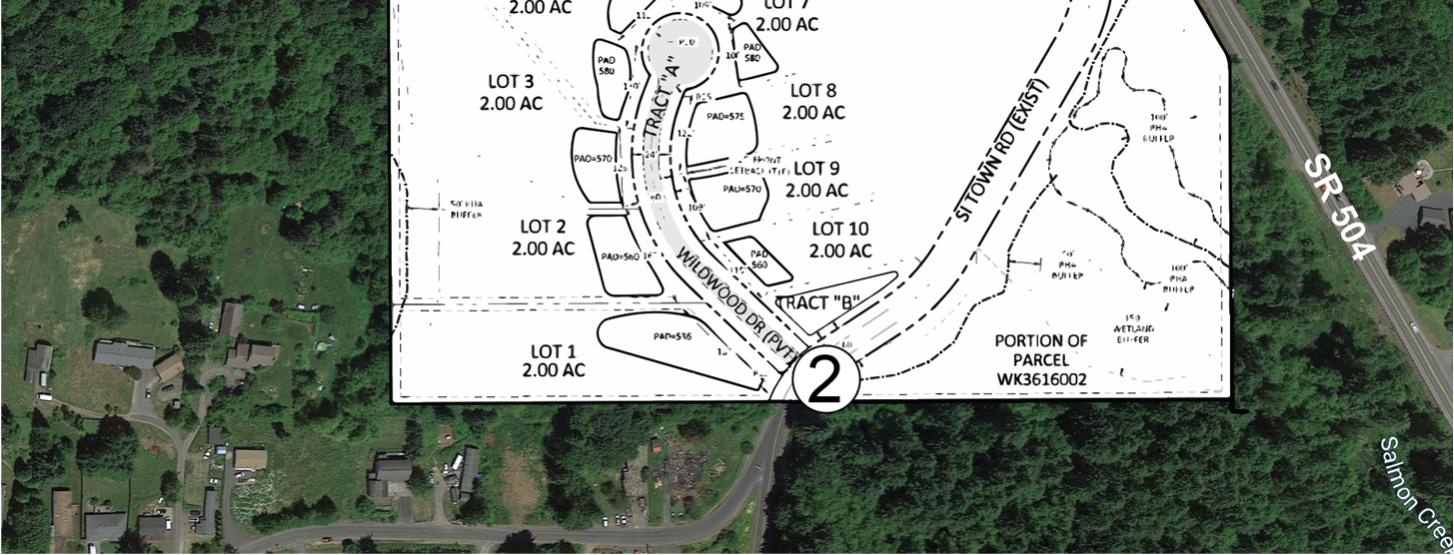
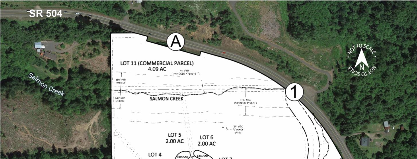 Figure 1: Vicinity Map
1 CoordinationbetweenGlobalTransportationEngineeringandWSDOT.Emaildated6/15/2022.
Figure 1: Vicinity Map
1 CoordinationbetweenGlobalTransportationEngineeringandWSDOT.Emaildated6/15/2022.
Ridge View Subdivision Traffic Impact Analysis
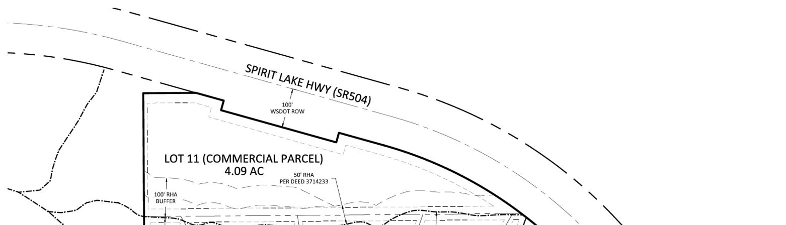
February 28, 2023
Page 2 of 12
EXECUTIVE SUMMARY
• A 10-unit residential development and one commercial lot are proposed for 102 Si Town Road in Cowlitz County, Washington. Access for the commercial building for Lot 11 will be via SR 504 and the residential units via a private road that accesses Si Town Road. No development is currently proposed for Lot 11.
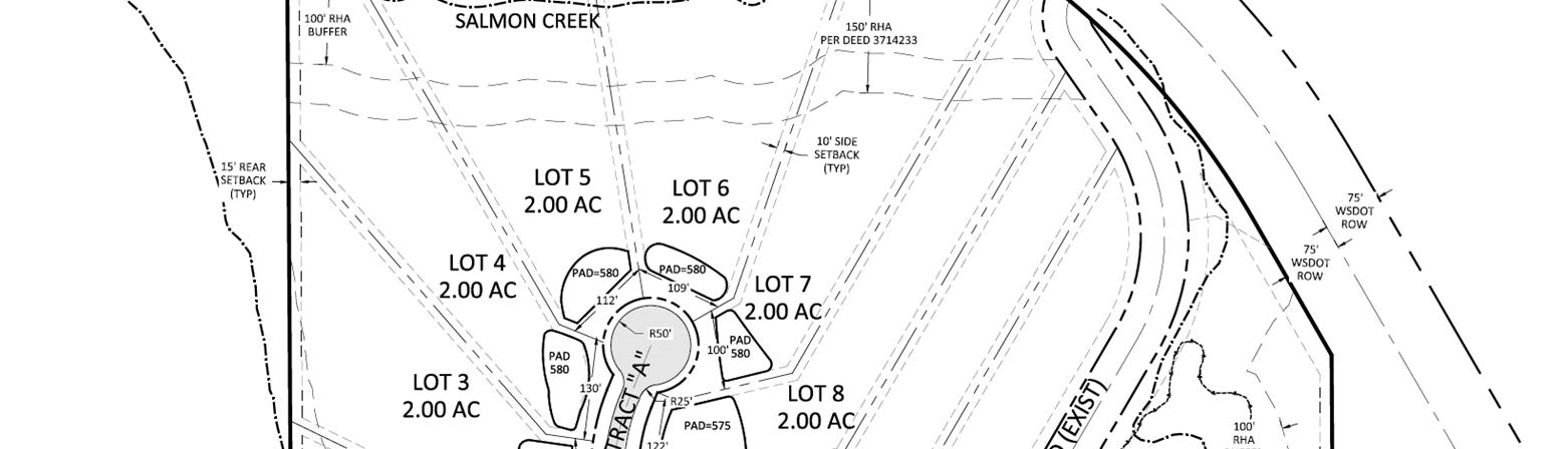
• An existing conditions analysis showed no mitigable crash patterns at the SR 504 and Si Town Road Intersection.

• A sight distance evaluation showed no sight distance issues at the proposed site access on SR 504.
• A traffic impact analysis was conducted to determine the 2022 existing conditions, 2025 background conditions, and 2025 buildout conditions for the SR 504 at Si Town Road intersection and the proposed site access onto SR 504. The analysis showed that the study intersections operate at acceptable performance levels through the 2025 buildout conditions. No capacity mitigations are recommended.
• A warrant analysis showed that no left or right-turn lanes are warranted at the proposed site access on SR 504.
• No mitigations are recommended associated with the proposed commercial or residential developments.
Figure 2: Preliminary Site Plan
Ridge View Subdivision Traffic Impact Analysis
February 28, 2023
Page 3 of 12
METHODOLOGY
The purpose of this analysis is to identify potential improvements at the study intersections and the proposed site access onto SR 504 to adequately serve existing and future horizon year traffic conditions based on standards established by Cowlitz County and the Washington State Department of Transportation (WSDOT). This traffic impact analysis considers the following elements:
• Project Description
• Traffic Analysis
o Existing Conditions Analysis
Description of Existing Facilities
Existing Intersection Performance
Crash Data Analysis
o Sight Distance Evaluation
o Projected Conditions Analysis
Trip Generation and Distribution
Background Growth
2025 Background Volumes
2025 Buildout Volumes
Future Intersection Performance
Warrant Analyses
• Left-Turn Lane Warrants
• Right-Turn Lane Warrants
• Conclusions and Recommendations
• Appendices
PROJECT DESCRIPTION
The proposed development will divide approximately 31.98 acres into 11 separate lots at 102 Si Town Road in Cowlitz County, Washington. Ten of these lots are for residential use and will gain access via a proposed private road that connects to Si Town Road. Lot 11 is modeled for a potential 5,000 square foot commercial office building with access via SR 504. Figure 2 shows a preliminary site plan.
• Based on the Pre-Application Notes2 for this project, a Traffic Impact Study must be provided for the commercial site on Lot 11. The Traffic Impact Study was developed based on the Washington Department of Transportation standards and is presented below.
TRAFFIC ANALYSIS
Existing Conditions Analysis
Existing transportation conditions were evaluated along SR 504 and Si Town Road. All modes of travel were evaluated, including pedestrians, bicycles, transit, and motor vehicles. The existing transportation conditions are summarized in Table 1.
2 Pre-ApplicationNotesdatedMarch22,2022.
Ridge View Subdivision Traffic Impact Analysis
February 28, 2023
Page 4 of 12
Table 1: Existing Conditions Within Study Area
Notes: 1 Based on the WSDOT Functional Classification Map.
2 Based on the Cowlitz County GIS Map, Street Classification
Existing Intersection Performance
An intersection performance analysis was conducted to document the existing operations for the SR 504 and Si Town Road Intersection and to develop a baseline for analyzing future intersection operational needs associated with the proposed development. Intersection operations were analyzed for the current peak hour performance. The peak periods analyzed for this evaluation include the AM peak period (7:00 AM to 9:00 AM) and the PM peak period (4:00 PM to 6:00 PM).
Turn movement count data was collected for both the AM and PM peak hours on June 22, 2022. Based on coordination with Cowlitz County3, June falls within the Mount Saint Helens tourist season and seasonal adjustment factors do not need to be considered in the traffic volume calculations. The detailed count data is included in Appendix A. Existing traffic volumes and lane configurations are shown in Figure 3.
The level of service analyses presented in this report has been completed using the Synchro (Version 11) analysis software. Synchro reports are based on the Highway Capacity Manual (HCM) 6th Edition methodology.
WSDOT utilizes level of service (LOS) standards to identify the acceptable levels of congestion. These standards also define the thresholds at which transportation system deficiencies are identified for improvements. The following level of service standards4 apply:
• LOS C or better for rural non-NHS facilities
Table 2 summarizes the existing traffic operations for the SR 504 and Si Town Road Intersection. Delay is reported as that of the worst stop-controlled approach for the unsignalized intersection. The detailed analysis results have been included in Appendix B.
Table 2: Existing Intersection Performance Summary, Unsignalized Intersections
Bold =doesnotmeetperformancestandards.
Under the existing intersection performance analysis, the SR 504 at Si Town Road Intersection meets performance standards during the AM and PM peak hours.
Roadway Functional Classification Posted Speed Limit Sidewalks Transit Bike Lanes Lane Geometry On-Street Parking SR504 RuralMinor Arterial 1 55mph None None None One13’-14’lane ineachdirection None SiTown Road RuralLocal Access 2 35mph2 None None None One12’-13’lane ineachdirection None
Intersection Peak Hour 2022 Existing Conditions Delay (sec) LOS V/C SR504atSiTown Road AM 11.4 B 0.03 PM 15.1 C 0.07 Notes:
3 Coordination between Cowlitz County Public Works and Global Transportation Engineering. Email dated 2/15/2023. 4 WSDOT Design Manual, Division 3, Chapter 320.05.


Figure 3:Traffic Volumes 2022 Existing Conditions SR 504 TH LT RT TH LT SR 504 0[2] 144[396] 8[29] 247[262] SR 504 TH TH SR 504 152[425] 261[283] Stop Sign Traffic Signal = Lane Configuration= Study Intersection = Left / Through / Right Turn STOP LT TH RT X AM [PM] = Peak Hour Volumes A 1 A 1
Ridge View Subdivision Traffic Impact Analysis
February 28, 2023
Page 6 of 12
Crash Analysis
Crash data for the five-year period from January 2017 through December 2021 was obtained from the Washington Department of Transportation and was reviewed to identify traffic safety concerns at the SR 504 at Si Town Road intersection. The crash rates presented in Table 3 are based on the number of crashes per million entering vehicles (MEV). Typically, further analysis and crash mitigations are not necessary unless its crash rate exceeds a threshold of 1.0 crashes per MEV.
Note:*M.E.V.-millionenteringvehicles.
As shown in Table 3, the intersection crash rate does not exceed 1.0 crashes per MEV and mitigations are not recommended. Of the reported crashes at the intersection, neither resulted in injury. One was a rear-end collision and the other was a turning-movement collision. No crash patterns were found. Detailed crash data is available in Appendix C.
Sight Distance Evaluation
Intersection sight distance for the proposed site access onto SR 504 was evaluated based on WSDOT standards and standards established by the American Association of State Highway and Transportation Official’s (AASHTO) standards. The sight distance measurement assumes stop control operations at the proposed site access. Sight distance was compared with WSDOT and AASHTO Intersection Sight Distance for the following cases:
• WSDOT Left and Right Access Sight Distance
• AASHTO Case B1 - Left Turn from the proposed access
• AASHTO Case B2 - Right Turn from the proposed access7
• WSDOT8 and AASHTO9 Stopping sight distance (SSD) Eastbound and Westbound Directions - Traffic approaching along SR 504 at the proposed access
Based on the posted speed limit of 55 mph on SR 504, the sight distance evaluation is summarized in Table 4. As shown in Table 4, all sight distance standards are met for the proposed site access.
Table 4: Sight Distance Evaluation Results
5 WSDOTDesignManualM22.01.20,Section1340.03(3).
6 AASHTO,CaseB1–Intersectionswithstopcontrolontheminorroad(AASHTO,CaseB1,Table9-6).
7 AASHTO,CaseB1–Intersectionswithstopcontrolontheminorroad(AASHTO,CaseB2,Table9-8).
8 WSDOTDesignManualM22.01.20,Section1260.03(1)(b).
9 AASHTOStoppingSightDistance,Table3-1.
Intersection Crash History (Years) Number of Crashes Crashes per year Annual Traffic Entering (veh/yr) Crash rate per M.E.V.* SR504atSiTownRoad 5 2 0.4 2,598,800 0.154
Table 3: Crash Analysis Summary
5
6
Location Posted Speed Limit Sight Distance Evaluated Estimated Available Sightline (ft) Sight Distance Standards (ft) Meets Standard? SR504 55mph WSDOT Totheleft >1000 495 Yes Totheright 725 495 Yes AASHTOCase B1:Left-turn Totheleft >1000 610 Yes Totheright 725 610 Yes AASHTOCase B2:RightTurn Totheleft >1000 530 Yes AASHTO& WSDOTSSD EB >1000 495 Yes WB 725 Yes
Ridge View Subdivision Traffic Impact Analysis
February 28, 2023
Page 7 of 12
Projected Conditions Analysis
A future conditions analysis was conducted to determine the expected traffic operating conditions for the study intersections and the proposed site access on SR 504 for the buildout year 2025.
Trip Generation and Distribution
Site trips for the development were determined based on land use trip rates taken from the Institute of Transportation Engineer’s (ITE) Trip Generation Manual, 11th Edition. Average rates were utilized in the trip generation development. Estimates were developed for AM, PM, and Average Daily Trips (ADT). In review of ITE land use codes, the trips generated by the commercial site will most closely be represented by the ITE Land Use Code 712 – Small Office Building. ITE Land Use Code 210 was utilized for the residential site. Table 5 summarizes the trip generation for the commercial and residential sites.
Trip distributions for the site generated traffic are based on the peak hour turning movement counts obtained for the SR 504 at Si Town Road intersection. Figure 4 summarizes the site trip distribution.
Background Growth
Based on coordination with WSDOT,10 a background growth Rate of 2 percent per year was determine for use in developing future volumes. A further seasonal adjustment of 1.08 was applied to the future volumes in accordance with the WSDOT Short Count Factoring Guide.11
In-Process Trips
Based on coordination with WSDOT and Cowlitz County, in-process trips from the Silver Lake Village, Phases II and III developments were included in the development of background traffic. Based on coordination with Cowlitz County staff, 90% of site trips from the Silver Lake Village development would pass by the intersection of SR 504 at Si Town Road. Phases II and III include 16 and 26 residential lots respectively for a total of 42 residential lots.
Site trips for the Silver Lake Village Development were determined based on land use trip rates taken from the Institute of Transportation Engineer’s (ITE) Trip Generation Manual, 11th Edition. Average rates were utilized in the trip generation development. Estimates were developed for AM, PM, and Average Daily Trips (ADT). In review of ITE land use codes, ITE Land Use Code 210 was utilized for this development. Table 6 shows the trip generation for the in-process developments. The Silver Lake Village II and III in-process trips and distribution are provided in Appendix D.
10 Emails from WSDOT engineering staff dated July 25, 2022. 11 WSDOT Short Count Factoring Guide, June 2020.
Land Use Size Weekday Daily AM Peak Hour PM Peak Hour Total Enter Exit Total Enter Exit CommercialSite SmallOfficeBuilding(ITE712) 5ksf 14.39 1.67 82% 18% 2.16 34% 66% SiteTrips 72 8 6 2 11 4 7 ResidentialSite SingleFamilyDetachedHousing(ITE210) 10 units 9.43 0.70 26% 74% 0.94 63% 37% SiteTrips 94 7 2 5 9 6 3
Table 5: Trip Generation Summary

Figure 4:Traffic Volumes Site Trip Distribution SR 504 TH LT RT TH LT SR 504 LT Stop Sign Traffic Signal = Lane Configuration= Study Intersection = Left / Through / Right Turn STOP LT TH RT X AM [PM] = Peak Hour Volumes 0[0] 1[4] 2[6] 4[2] 1 SR 504 TH LT RT TH LT SR 504 4[2] 2[6] 2[2] 5[3] A A 1 2 Si Town Road TH TH LT Si Town Road 2[6] 2
Ridge View Subdivision Traffic Impact Analysis
February 28, 2023
Page 9 of 12
Table
2025 Background Traffic Volumes
Background growth and in-process trips were added to existing turn movement volumes to develop the 2025 background volumes. The 2025 Background volumes are shown in Figure 5.
2025 Buildout Traffic Volumes
Commercial and residential site trips were added to the 2025 background volumes to develop the 2025 buildout volumes. These volumes are shown in Figure 6.
Future Intersection Performance
Table 6 summarizes the AM and PM peak hour performance results for the 2025 intersection analyses. The HCM reports for the future analyses are included in Appendix E.
Table 6: 2025 Intersection Performance Analysis
Notes: Bold =doesnotmeetperformancestandards.
As shown in Table 6, The SR 504 at Si Town Road intersection and the proposed site access onto SR 504 operate at acceptable levels of service during the AM and PM peak hours for both the 2025 Background and 2025 Buildout Scenerios.
Warrants Analyses
Left-Turn Lane Warrants
Left-turn lane warrants were reviewed for the proposed site access onto SR 504 using the Highway Research Board Report 211.12 Left turn warrants were evaluated for each study scenario. Table 7 shows a summary of the left turn warrant analysis results.
Left-turn lanes are not warranted under any conditions for any of the turning movements. Complete analysis details can be found in Appendix F.
Land Use Size Weekday Daily AM Peak Hour PM Peak Hour Total Enter Exit Total Enter Exit SilverLakeVillageIIandIII SingleFamilyDetachedHousing(ITE210) 42units 9.43 0.70 26% 74% 0.94 63% 37% SiteTrips 396 29 7 22 39 25 14
6: In-Process Trip Generation Summary
Intersection Peak Hour 2025 Background 2025 Buildout Delay (sec) LOS V/C Delay (sec) LOS V/C UnsignalizedIntersection SR504atSiTownRoad AM 12.3 B 0.04 12.4 B 0.05 PM 17.8 C 0.09 18.2 C 0.11 WildwoodDriveatSi TownRoad AM - - - 8.7 A 0.01 PM - - - 8.9 A 0.01 ProposedCommercial SiteAccessonSR504 AM - - - 10.8 B 0.01 PM - - - 14.4 B 0.02
12 Highway Research Board, Volume Warrants for Left-Turn Storage Lanes at Unsignalized Grade Intersection, Report 211.
Figure 5:Traffic Volumes 2025 Background Conditions SR 504 TH LT RT TH LT SR 504 Stop Sign Traffic Signal = Lane Configuration= Study Intersection = Left / Through / Right Turn STOP LT TH RT X AM [PM] = Peak Hour Volumes 0[2] 171 [476] 9 [33] 303[313] 1 SR 504 TH TH SR 504 180[510] 319[337] A A 1 LT Si Town Road TH TH LT Si Town Road 0[0] 2 16[26] 0[0] 9[35] 2


Figure 6:Traffic Volumes 2025 Buildout Conditions SR 504 TH LT RT TH LT SR 504 Stop Sign Traffic Signal = Lane Configuration= Study Intersection = Left / Through / Right Turn STOP LT TH RT X AM [PM] = Peak Hour Volumes 0[2] 172[480] 11[39] 307[315] 1 SR 504 TH LT RT TH LT SR 504 4[2] 182[516] 2[2] 324[340] A A 1 LT Si Town Road TH TH LT Si Town Road 2[6] 2 16[26] 0[0] 9[35] 2
Ridge View Subdivision Traffic Impact Analysis
February 28, 2023
Page 12 of 12
Table 7: Left Turn Lane Warrants Analysis
Notes:HRB=HighwayResearchBoard
Right-Turn Lane Warrants
Right-turn lane warrants were reviewed for the proposed site access onto SR 504 using the National Cooperative Highway Research Program (NCHRP) Report 279. Right turn warrants were evaluated for each study scenario. Table 8 shows a summary of the right turn warrant analysis results.
Table 8: Right Turn Lane Warrants Analysis
Right turn lanes are not warranted under 2025 buildout conditions for the site access. Complete analysis details can be found in Appendix F.
CONCLUSIONS AND RECOMMENDATIONS
A traffic analysis was conducted for the proposed commercial and residential development at 102 Si Town Road in Cowlitz County, Washington. The proposed development will consist of a 10-unit singlefamily residential development that will gain access via a proposed private road that connects to Si Town Road. Lot 11 is modeled for a potential 5,000 square foot commercial office building with access via SR 504.. The study area for the analysis included the SR 504 at Si Town Road intersection, Si Town Road at Wildwood Drive, and a potential site access to SR 504 from Lot 11.
The study intersections operate at an acceptable level of service under all scenarios. No capacity mitigations are recommended.
A crash analysis was conducted and showed no crash patterns at the SR 504 and Si Town Road Intersection. No safety mitigations are recommended.
A sight distance evaluation was conducted for the proposed site access location. No sight distance issues were identified.
Left-turn Lane warrants were reviewed for the proposed site access using the Highway Research Board Report 211. Left-turn lanes are not warranted under any analysis scenario.
Right-turn Lane warrants were reviewed for the proposed site access using the National Cooperative Highway Research Program (NCHRP) Report 279. Right-turn lanes are not warranted under any analysis scenario.
SR 504 at Site Access Movement Left Turn HRB Warrant Met? 2022 Existing 2025 Background 2025 Buildout AMPeakHour NBLT WBLT No No No No No No PMPeakHour NBLT WBLT No No No No No No
SR 504 at Site Access Movement Right Turn NCHRP Warrant Met? 2022 Existing 2025 Background 2025 Buildout AMPeakHour EBR No No No PMPeakHour EBR No No No
Appendix
Appendix A – Count Data


Type of peak hour being reported: Intersection Peak Method for determining peak hour: Total Entering Volume LOCATION: LOCATION: Si Town Rd -- SR 504 (Spirit Lake Hwy) QC JOB #: #: 15863701 CITY/STATE: Cowlitz, WA DATE: DATE: Wed, Jun 22 2022 0 0 0 0 0 262 1 0 247 144 090 090 247 153 8 0 144 14 0 0 8 14 Peak-Hour: 8:00 AM -- 9:00 AM Peak-Hour: AM -- 9:00 AM Peak 15-Min: 8:30 AM -- 8:45 AM Peak 15-Min: AM -- 8:45 AM 0 0 0 0 0 61 0 0 65 188 65 19 25 0 188 0 0 0 25 0 0 0 0 0 0 0 0 0 0 0 0 0 0 0 0 0 N/A N/A N/A N/A N/A N/A N/A N/A 15-Min Count 15-Min Count Period Beginning At At Si Town Rd Si Rd ((Northbound) Northbound) Si Town Rd Si Town Rd ((Southbound) Southbound) SR 504 (Spirit Lake Hwy) SR (Spirit Lake Hwy) ((Eastbound) Eastbound) SR 504 (Spirit Lake Hwy) SR 504 (Spirit Lake Hwy) ((Westbound) Westbound) Total Total Hourly Totals Totals Left Left Thru Right Right U Left Thru Thru Right U U Left Left Thru Thru Right Right U U Left Left Thru Thru Right U U 7:00 AM 4 0 0 0 0 0 0 0 0 17 0 0 0 47 0 0 68 7:15 AM 2 0 0 0 0 0 0 0 0 29 1 0 0 72 0 0 104 7:30 AM 5 0 0 0 0 0 0 0 0 24 1 0 0 78 0 0 108 7:45 AM 6 0 0 0 0 0 0 0 0 30 0 0 0 62 0 0 98 378 8:00 AM 4 0 0 0 0 0 0 0 0 20 0 0 0 65 0 0 89 399 8:15 AM 3 0 0 0 0 0 0 0 0 45 2 0 0 59 0 0 109 404 8:30 AM 5 0 0 0 0 0 0 0 0 36 2 0 0 72 0 0 115 411 8:45 AM 2 0 0 0 0 0 0 0 0 43 4 1 0 51 0 0 101 414 Peak 15-Min Peak Flowrates Flowrates Northbound Northbound Southbound Southbound Eastbound Eastbound Westbound Westbound Total Left Left Thru Right Right U Left Thru Thru Right U U Left Left Thru Thru Right Right U U Left Left Thru Thru Right U U All Vehicles 20 0 0 0 0 0 0 0 0 144 8 0 0 288 0 0 460 Heavy Trucks 0 0 0 0 0 0 0 24 0 0 12 0 36 Buses Pedestrians 0 0 0 0 0 Bicycles 0 0 0 0 0 0 0 0 0 0 0 0 0 Scooters Comments: Report generated on 7/5/2022 7:49 AM SOURCE: Quality Counts, LLC (http://www qualitycounts net) 1-877-580-2212 Page 1 of 1
Type of peak hour being reported: Intersection Peak Method for determining peak hour: Total Entering Volume LOCATION: LOCATION: Si Town Rd -- SR 504 (Spirit Lake Hwy) QC JOB #: #: 15863702 CITY/STATE: Cowlitz, WA DATE: DATE: Wed, Jun 22 2022 0 0 0 0 0 283 0 0 264 396 089 089 262 425 29 2 398 21 0 2 31 23 Peak-Hour: 4:30 PM -- 5:30 PM Peak-Hour: PM -- 5:30 PM Peak 15-Min: 5:00 PM -- 5:15 PM 15-Min: PM -- PM 0 0 0 0 0 53 0 0 57 45 53 45 34 50 45 48 0 0 65 43 0 0 0 0 0 0 0 0 0 0 0 0 0 0 0 0 N/A N/A N/A N/A N/A N/A N/A N/A 15-Min Count 15-Min Count Period Beginning At At Si Town Rd Si Rd ((Northbound) Northbound) Si Town Rd Si Town Rd ((Southbound) Southbound) SR 504 (Spirit Lake Hwy) SR (Spirit Lake Hwy) ((Eastbound) Eastbound) SR 504 (Spirit Lake Hwy) SR 504 (Spirit Lake Hwy) ((Westbound) Westbound) Total Total Hourly Totals Totals Left Left Thru Right Right U Left Thru Thru Right U U Left Left Thru Thru Right Right U U Left Left Thru Thru Right U U 4:00 PM 0 0 0 0 0 0 0 0 0 100 4 0 0 62 0 0 166 4:15 PM 1 0 0 0 0 0 0 0 0 76 4 1 0 69 0 0 151 4:30 PM 4 0 1 0 0 0 0 0 0 75 5 0 1 71 0 0 157 4:45 PM 5 0 0 0 0 0 0 0 0 99 9 0 1 57 0 0 171 645 5:00 PM 7 0 1 0 0 0 0 0 0 112 8 0 0 71 0 0 199 678 5:15 PM 5 0 0 0 0 0 0 0 0 110 7 0 0 63 0 0 185 712 5:30 PM 5 0 0 0 0 0 0 0 0 81 5 0 0 52 0 0 143 698 5:45 PM 2 0 0 0 0 0 0 0 0 81 7 0 0 44 0 0 134 661 Peak 15-Min Peak Flowrates Flowrates Northbound Northbound Southbound Southbound Eastbound Eastbound Westbound Westbound Total Left Left Thru Right Right U Left Thru Thru Right U U Left Left Thru Thru Right Right U U Left Left Thru Thru Right U U All Vehicles 28 0 4 0 0 0 0 0 0 448 32 0 0 284 0 0 796 Heavy Trucks 0 0 0 0 0 0 0 8 0 0 12 0 20 Buses Pedestrians 0 0 0 0 0 Bicycles 0 0 0 0 0 0 0 0 0 0 0 0 0 Scooters Comments: Report generated on 7/5/2022 7:49 AM SOURCE: Quality Counts, LLC (http://www qualitycounts net) 1-877-580-2212 Page 1 of 1
Appendix B – Existing Intersection Performance HCM Reports
Intersection
Int Delay, s/veh0.4
MovementEBTEBRWBLWBTNBLNBR
Lane Configurations
Traffic Vol, veh/h14480247140
Future Vol, veh/h14480247140
Conflicting Peds, #/hr000000
Sign ControlFreeFreeFreeFreeStopStop
RT Channelized-None-None-None
Storage Length----0-
Veh in Median Storage, #0--00-
Grade, %0--00-
Peak Hour Factor909090909090
Heavy Vehicles, %19257000
Mvmt Flow16090274160
Major/MinorMajor1Major2Minor1
Conflicting Flow All001690439165
Stage 1----165Stage 2----274-
Pot Cap-1 Maneuver--1379-579885 Stage 1----869Stage 2----777-
Platoon blocked, %---
Mov Cap-1 Maneuver--1379-579885
Mov Cap-2 Maneuver----579Stage 1----869Stage 2----777-
ApproachEBWBNB
HCM Control Delay, s0011.4
HCM LOSB
Minor Lane/Major MvmtNBLn1EBTEBRWBLWBT Capacity (veh/h)579--1379HCM Lane V/C Ratio0.027----
HCM 6th TWSC 1: Si Town Road & SR 504 07/05/2022 102 Si Town Road TIA 7:30 am 07/05/2022 2022 Existing ConditionsSynchro 10 Light Report AM Peak HourPage 1
Critical Hdwy--4.17-6.46.2 Critical Hdwy Stg 1----5.4Critical Hdwy Stg 2----5.4Follow-up Hdwy--2.263-3.53.3
HCM
HCM
HCM Control Delay (s)11.4--0-
Lane LOSB--A-
95th %tile Q(veh)0.1--0-
Intersection
Int Delay, s/veh0.5
MovementEBTEBRWBLWBTNBLNBR
Lane Configurations
Traffic Vol, veh/h396292262212
Future Vol, veh/h396292262212
Conflicting Peds, #/hr000000
Sign ControlFreeFreeFreeFreeStopStop
RT Channelized-None-None-None
Storage Length----0-
Veh in Median Storage, #0--00-
Grade, %0--00-
Peak Hour Factor898989898989
Heavy Vehicles, %5355050
Mvmt Flow445332294242
Major/MinorMajor1Major2Minor1 Conflicting
ApproachEBWBNB
HCM 6th TWSC 1: Si Town Road & SR 504 07/05/2022 102 Si Town Road TIA 4:30 am 07/05/2022 2022 Existing ConditionsSynchro 10 Light Report PM Peak HourPage 1
Flow
Stage 1----462Stage 2----298Critical Hdwy--4.15-6.456.2 Critical Hdwy Stg 1----5.45Critical Hdwy Stg 2----5.45Follow-up Hdwy--2.245-3.5453.3 Pot Cap-1 Maneuver--1069-370604 Stage 1----628Stage 2----746Platoon blocked, %--Mov Cap-1 Maneuver--1069-369604 Mov Cap-2 Maneuver----369Stage 1----628Stage 2----745-
All004780760462
HCM Control Delay, s00.115.1 HCM LOSC Minor Lane/Major MvmtNBLn1EBTEBRWBLWBT Capacity (veh/h)382--1069HCM Lane V/C Ratio0.068--0.002HCM Control Delay (s)15.1--8.40 HCM Lane LOSC--AA HCM 95th %tile Q(veh)0.2--0-
Appendix C – Crash Analysis
OFFICERREPORTEDCRASHESTHATOCCURREDATTHEFOLLOWINGINTERSECTIONINCOWLITZCOUNTY
SR504(MP2.68-2.72)@SITOWNRD
01/01/2017 - 12/31/2021
Under 23 U.S. Code § 148 and 23 U.S. Code § 407, safety data, reports, surveys, schedules, lists compiled or collected for the purpose of identifying, evaluating, or planning the safety enhancement of potential crash sites, hazardous roadway conditions, or railway-highway crossings are not subject to discovery or admitted into evidence in a Federal or State court proceeding or considered for other purposes in any action for damages arising from any occurrence at a location mentioned or addressed in such reports, surveys, schedules, lists, or data.
StateRouteCowlitz5042.70NoE95145907/29/201912:30NoApparentInjury00200
StateRouteCowlitz5042.70NoE74150111/11/201713:31NoApparentInjury00200
JURISDICTIONCOUNTYCITY PRIMARY TRAFFICWAYMILEPOST A / B SRONLY HISTORY/ SUSPENSE REPORT NUMBERDATETIME MOSTSEVERE INJURYTYPE # I N J # F A T # V E H # P E D S # B I K E S
WSDOT - Transportation Data, GIS and Modeling Office Crash Data and Reporting Branch - JB07/05/20221 of 5
VEHICLE1TYPEVEHICLE2TYPEJUNCTIONRELATIONSHIPWEATHER Pickup,PanelTruckorVanetteunder10,000lbOtherAtIntersectionandRelatedClearorPartlyCloudy PassengerCarPickup,PanelTruckorVanetteunder10,000lbAtIntersectionandRelatedClearorPartlyCloudy
WSDOT - Transportation Data, GIS and Modeling Office Crash Data and Reporting Branch - JB07/05/20222 of 5
ROADWAY SURFACE CONDITION LIGHTING
CONDITIONFIRSTCOLLISIONTYPE/OBJECTSTRUCKVEHICLE1ACTIONVEHICLE2ACTION
VEHICLE1 COMPASS DIRECTION FROM DryDaylightEnteringatangleMakingLeftTurnGoingStraightAheadSouth DryDaylightFromsamedirection-bothgoingstraight-onestopped-rear-endGoingStraightAheadStoppedinRoadwayEast
WSDOT - Transportation Data, GIS and Modeling Office Crash Data and Reporting Branch - JB07/05/20223 of 5
VEHICLE1 COMPASS DIRECTION TO
VEHICLE2 COMPASS DIRECTIONFROM
VEHICLE2 COMPASS DIRECTIONTO MVDRIVERCONTRIBUTING CIRCUMSTANCE1(UNIT1)
MVDRIVER CONTRIBUTING CIRCUMSTANCE2 (UNIT1)
MVDRIVER CONTRIBUTING CIRCUMSTANCE3 (UNIT1)
MVDRIVER CONTRIBUTING CIRCUMSTANCE1 (UNIT2)
WestEastWestDidNotGrantRWtoVehicleNone
WestVehicleStoppedVehicleStoppedInattentionFollowTooCloselyNone
WSDOT - Transportation Data, GIS and Modeling Office Crash Data and Reporting Branch - JB07/05/20224 of 5
MVDRIVER CONTRIBUTING CIRCUMSTANCE2 (UNIT2)
MVDRIVER CONTRIBUTING CIRCUMSTANCE3 (UNIT2)
FIRSTIMPACTLOCATION (City,County&Misc Trafficways-2010forward)
WASTATE PLANE
SOUTH-X 2010FORWARD
WASTATE PLANE
SOUTH-Y 2010FORWARD
Lane1DecreasingMilepost1042417.09362804.24
Lane1DecreasingMilepost1042405.57362815.5
WSDOT - Transportation Data, GIS and Modeling Office Crash Data and Reporting Branch - JB07/05/20225 of 5
Appendix D – In Process Trips
Appendix D: In-ProcessTrips SR 504 TH LT RT TH LT SR 504 Stop Sign Traffic Signal = Lane Configuration= Study Intersection = Left / Through / Right Turn STOP LT TH RT X AM [PM] = Peak Hour Volumes 6[23] 20[13] 1 SR 504 TH LT RT TH LT SR 504 6[23] 20[13] A A 1
Richard Martin
From: Harbison, Patrick <HarbisonP@cowlitzwa.gov>
Sent: Wednesday, February 15, 2023 1:50 PM
To: Richard Martin
Cc: Monica Leal
Subject: RE: Ridge View Subdivision Traffic Study
Attachments: Site Access Analysis.pdf
I can’t seem to find Phase 2's traffic study. It was 16 residential lots at the same location as 3. Not sure if that helps. I would assume 90% of the trips generated by phase 2, pass by the si town/SLH intersection.
Patrick N. Harbison, P.E.
UtilitiesManager
CowlitzCountyPublicWorks
160013th AveSouth Kelso,WA98626
(360)577-3030ext.6536
(TheCountyrecentlyswitchedovertoOffice365andchangedouremaildomain.Pleasenotemynewemailandupdate yourcontactinfoasnecessary. Thankyou.)
From: Richard Martin <Richard.Martin@globaltranseng.com>
Sent: Wednesday, February 15, 2023 1:42 PM
To: Harbison, Patrick <HarbisonP@cowlitzwa.gov>
Cc: Monica Leal <monica.leal@globaltranseng.com>
Subject: Ridge View Subdivision Traffic Study
Hello Patrick,
I’ve been working with Standridge Inc on the traffic study for the Ridge View Subdivision at 102 Si Town Road. Based on comments received I wanted to ask if you could send us the in-process trips from Silver Lake Village II and III and any other in-process developments that show site trip distribution along SR 504 at Si Town Road so that we can update our analysis. Thank you,
Richard C. “Rocky” Martin, EI
Transportation Engineering Associate
227 SW Pine Street | Suite 220 | Portland, OR 97204 Mobile: 503-799-1039 | Office: 503-719-7997 richard.martin@globaltranseng.com www.globaltranseng.com

1


Appendix E – Future Intersection Performance HCM Reports
Intersection
Int Delay, s/veh0.4
MovementEBTEBRWBLWBTNBLNBR
Lane Configurations
Traffic Vol, veh/h17190303160
Future Vol, veh/h17190303160
Conflicting Peds, #/hr000000
Sign ControlFreeFreeFreeFreeStopStop
RT Channelized-None-None-None
Storage Length----0-
Veh in Median Storage, #0--00-
Grade, %0--00-
Peak Hour Factor909090909090
Heavy Vehicles, %19257000
Mvmt Flow190100337180
Major/MinorMajor1Major2Minor1
Conflicting Flow All002000532195 Stage 1----195Stage 2----337-
Pot Cap-1 Maneuver--1343-512851 Stage 1----843Stage 2----728-
Platoon blocked, %---
Mov Cap-1 Maneuver--1343-512851
Mov Cap-2 Maneuver----512Stage 1----843Stage 2----728-
ApproachEBWBNB
HCM Control Delay, s0012.3
HCM LOSB
Minor Lane/Major MvmtNBLn1EBTEBRWBLWBT Capacity (veh/h)512--1343HCM Lane V/C Ratio0.035----
6th TWSC 1: Si Town Road & SR 504 02/17/2023 102 Si Town Road TIA 7:30 am 07/05/2022 2025 Background ConditionsSynchro 10 Light Report AM Peak HourPage 1
HCM
Critical
Critical Hdwy Stg 1----5.4Critical Hdwy Stg 2----5.4Follow-up Hdwy--2.263-3.53.3
Hdwy--4.17-6.46.2
HCM
HCM Control Delay (s)12.3--0HCM Lane LOSB--A-
95th %tile Q(veh)0.1--0-
Intersection
Int Delay, s/veh0.6
MovementEBTEBRWBLWBTNBLNBR
Lane Configurations
Traffic Vol, veh/h476332313242
Future Vol, veh/h476332313242
Conflicting Peds, #/hr000000
Sign ControlFreeFreeFreeFreeStopStop
RT Channelized-None-None-None
Storage Length----0-
Veh in Median Storage, #0--00-
Grade, %0--00-
Peak Hour Factor898989898989
Heavy Vehicles, %5355050
Mvmt Flow535372352272
Major/MinorMajor1Major2Minor1
ApproachEBWBNB
HCM 6th TWSC 1: Si Town Road & SR 504 02/17/2023 102 Si Town Road TIA 4:30 am 07/05/2022 2025 Background ConditionsSynchro 10 Light Report PM Peak HourPage 1
Flow All005720910554 Stage 1----554Stage 2----356Critical Hdwy--4.15-6.456.2 Critical Hdwy Stg 1----5.45Critical Hdwy Stg 2----5.45Follow-up Hdwy--2.245-3.5453.3 Pot Cap-1 Maneuver--986-301536 Stage 1----570Stage 2----702Platoon blocked, %--Mov Cap-1 Maneuver--986-300536 Mov Cap-2 Maneuver----300Stage 1----570Stage 2----700-
Conflicting
HCM Control Delay, s00.117.8 HCM LOSC Minor Lane/Major MvmtNBLn1EBTEBRWBLWBT Capacity (veh/h)311--986HCM Lane V/C Ratio0.094--0.002HCM Control Delay (s)17.8--8.70 HCM Lane LOSC--AA HCM 95th %tile Q(veh)0.3--0-
Intersection
Int Delay, s/veh0.5
MovementEBTEBRWBLWBTNBLNBR
Lane Configurations
Traffic Vol, veh/h172110307210
Future Vol, veh/h172110307210
Conflicting Peds, #/hr000000
Sign ControlFreeFreeFreeFreeStopStop
RT Channelized-None-None-None
Storage Length----0-
Veh in Median Storage, #0--00-
Grade, %0--00-
Peak Hour Factor909090909090
Heavy Vehicles, %19257000
Mvmt Flow191120341230
Major/MinorMajor1Major2Minor1
HCM 6th TWSC 1: Si Town Road & SR 504 02/28/2023 102 Si Town Road TIA 12:00 am 02/28/2023 2025 Buildout ConditionsSynchro 10 Light Report AM Peak HourPage 1
Stage
Stage 2----341Critical Hdwy--4.17-6.46.2 Critical Hdwy Stg 1----5.4Critical Hdwy Stg 2----5.4Follow-up Hdwy--2.263-3.53.3 Pot Cap-1 Maneuver--1339-508849 Stage 1----841Stage 2----725Platoon blocked, %--Mov Cap-1 Maneuver--1339-508849 Mov Cap-2 Maneuver----508Stage 1----841Stage 2----725-
Conflicting Flow All002030538197
1----197-
Control Delay,
HCM LOSB
Lane/Major MvmtNBLn1EBTEBRWBLWBT Capacity (veh/h)508--1339HCM Lane V/C Ratio0.046---HCM Control Delay (s)12.4--0HCM Lane LOSB--AHCM 95th %tile Q(veh)0.1--0-
ApproachEBWBNB HCM
s0012.4
Minor
Intersection
Int Delay, s/veh0.1
MovementEBTEBRWBLWBTNBLNBR
Lane Configurations
Traffic Vol, veh/h1822432411
Future Vol, veh/h1822432411
Conflicting Peds, #/hr000000
Sign ControlFreeFreeFreeFreeStopStop
RT Channelized-None-None-None
Storage Length----0-
Veh in Median Storage, #0--00-
Grade, %0--00-
Peak Hour Factor929292929292
Heavy Vehicles, %222222
Mvmt Flow1982435211
Major/MinorMajor1Major2Minor1
ApproachEBWBNB HCM
6th TWSC 2: Site Access & SR 504 02/28/2023 102 Si Town Road TIA 12:00 am 02/28/2023 2025 Buildout ConditionsSynchro 10 Light Report AM Peak HourPage 2
HCM
Stage 1----199Stage 2----360Critical Hdwy--4.12-6.426.22 Critical Hdwy Stg 1----5.42Critical Hdwy Stg 2----5.42Follow-up Hdwy--2.218-3.5183.318 Pot Cap-1 Maneuver--1372-490842 Stage 1----835Stage 2----706-
%--Mov Cap-1 Maneuver--1372-488842
Cap-2 Maneuver----488Stage 1----835Stage 2----703-
Conflicting Flow All002000559199
Platoon blocked,
Mov
Control
LOSB
Lane/Major MvmtNBLn1EBTEBRWBLWBT Capacity (veh/h)618--1372HCM Lane V/C Ratio0.004--0.003HCM Control Delay (s)10.8--7.60 HCM Lane LOSB--AA HCM 95th %tile Q(veh)0--0-
Delay, s00.110.8 HCM
Minor
Intersection
Int Delay, s/veh1.4
MovementEBLEBRNBLNBTSBTSBR
Lane Configurations
Traffic Vol, veh/h5001692
Future Vol, veh/h5001692
Conflicting Peds, #/hr000000
Sign ControlStopStopFreeFreeFreeFree
RT Channelized-None-None-None
Storage Length0-----
Veh in Median Storage, #0--00-
Grade, %0--00-
Peak Hour Factor929292929292
Heavy Vehicles, %222222
Mvmt Flow50017102
Major/MinorMinor2Major1Major2
Conflicting Flow All2811120-0
Stage 111-----
Stage 217-----
Critical Hdwy6.426.224.12---
Critical Hdwy Stg 15.42-----
Critical Hdwy Stg 25.42-----
Follow-up Hdwy3.5183.3182.218---
Pot Cap-1 Maneuver98710701607---
Stage 11012-----
Stage 21006-----
Platoon blocked, %---
Mov Cap-1 Maneuver98710701607---
Mov Cap-2 Maneuver987-----
Stage 11012-----
Stage 21006-----
ApproachEBNBSB
HCM Control Delay, s8.700
HCM LOSA
Minor Lane/Major MvmtNBLNBTEBLn1SBTSBR
Capacity (veh/h)1607-987--
HCM Lane V/C Ratio--0.006--
HCM Control Delay (s)0-8.7--
HCM Lane LOSA-A--
HCM 95th %tile Q(veh)0-0--
6th TWSC 3: Si Town Road & Wildwood Drive 02/28/2023 102 Si Town Road TIA 12:00 am 02/28/2023 2025 Buildout ConditionsSynchro 10 Light Report AM Peak HourPage 3
HCM
Intersection
Int Delay, s/veh0.6
MovementEBTEBRWBLWBTNBLNBR
Lane Configurations
Traffic Vol, veh/h480392315272
Future Vol, veh/h480392315272
Conflicting Peds, #/hr000000
Sign ControlFreeFreeFreeFreeStopStop
RT Channelized-None-None-None
Storage Length----0-
Veh in Median Storage, #0--00-
Grade, %0--00-
Peak Hour Factor898989898989
Heavy Vehicles, %5355050
Mvmt Flow539442354302
Major/MinorMajor1Major2Minor1
HCM 6th TWSC 1: Si Town Road & SR 504 02/28/2023 102 Si Town Road TIA 12:00 am 02/28/2023 2025 Buildout ConditionsSynchro 10 Light Report PM Peak HourPage 1
Conflicting Flow All005830919561 Stage 1----561Stage 2----358Critical Hdwy--4.15-6.456.2 Critical Hdwy Stg 1----5.45Critical Hdwy Stg 2----5.45Follow-up Hdwy--2.245-3.5453.3 Pot Cap-1 Maneuver--977-297531 Stage 1----565Stage 2----701Platoon blocked, %--Mov Cap-1 Maneuver--977-296531 Mov Cap-2 Maneuver----296Stage 1----565Stage 2----699-
HCM Control Delay, s00.118.2 HCM LOSC Minor Lane/Major MvmtNBLn1EBTEBRWBLWBT Capacity (veh/h)305--977HCM Lane V/C Ratio0.107--0.002HCM Control Delay (s)18.2--8.70 HCM Lane LOSC--AA HCM 95th %tile Q(veh)0.4--0-
ApproachEBWBNB
Intersection
Int Delay, s/veh0.2
MovementEBTEBRWBLWBTNBLNBR
Lane Configurations
Traffic Vol, veh/h5162234034
Future Vol, veh/h5162234034
Conflicting Peds, #/hr000000
Sign ControlFreeFreeFreeFreeStopStop
RT Channelized-None-None-None
Storage Length----0-
Veh in Median Storage, #0--00-
Grade, %0--00-
Peak Hour Factor929292929292
Heavy Vehicles, %222222
Mvmt Flow5612237034
Major/MinorMajor1Major2Minor1
Conflicting Flow All005630936562
Platoon blocked, %---
Mov Cap-1 Maneuver--1008-293526
Mov Cap-2 Maneuver----293Stage 1----571Stage 2----695-
ApproachEBWBNB
HCM Control Delay, s00.114.4 HCM LOSB
6th TWSC 2: Site Access & SR 504 02/28/2023 102 Si Town Road TIA 12:00 am 02/28/2023 2025 Buildout ConditionsSynchro 10 Light Report PM Peak HourPage 2
HCM
Stage
Critical Hdwy--4.12-6.426.22 Critical Hdwy Stg 1----5.42Critical Hdwy Stg 2----5.42Follow-up Hdwy--2.218-3.5183.318
Stage 1----562-
2----374-
Pot Cap-1 Maneuver--1008-294526 Stage 1----571Stage 2----696-
Capacity
HCM Lane V/C Ratio0.019--0.002HCM Control Delay (s)14.4--8.60 HCM Lane LOSB--AA HCM 95th %tile Q(veh)0.1--0-
Minor Lane/Major MvmtNBLn1EBTEBRWBLWBT
(veh/h)392--1008-
Intersection
Int Delay, s/veh0.4
MovementEBLEBRNBLNBTSBTSBR
Lane Configurations
Traffic Vol, veh/h30026356
Future Vol, veh/h30026356
Conflicting Peds, #/hr000000
Sign ControlStopStopFreeFreeFreeFree
RT Channelized-None-None-None
Storage Length0-----
Veh in Median Storage, #0--00-
Grade, %0--00-
Peak Hour Factor929292929292
Heavy Vehicles, %222222
Mvmt Flow30028387
Major/MinorMinor2Major1Major2
Conflicting Flow All7042450-0
Stage 142-----
Stage 228-----
Critical Hdwy6.426.224.12---
Critical Hdwy Stg 15.42-----
Critical Hdwy Stg 25.42-----
Follow-up Hdwy3.5183.3182.218---
Pot Cap-1 Maneuver93410291563---
Stage 1980-----
Stage 2995-----
Platoon blocked, %---
Mov Cap-1 Maneuver93410291563---
Mov Cap-2 Maneuver934-----
Stage 1980-----
Stage 2995-----
ApproachEBNBSB
HCM Control Delay, s8.900
HCM LOSA
Minor Lane/Major MvmtNBLNBTEBLn1SBTSBR
Capacity (veh/h)1563-934--
HCM Lane V/C Ratio--0.003--
HCM Control Delay (s)0-8.9--
HCM Lane LOSA-A--
HCM 95th %tile Q(veh)0-0--
HCM 6th TWSC 3: Si Town Road & Wildwood Drive 02/28/2023 102 Si Town Road TIA 12:00 am 02/28/2023 2025 Buildout ConditionsSynchro 10 Light Report PM Peak HourPage 3
Appendix F – Warrant Analysis
LT % Warrant Factor 5% Warrant Va Va Warrant Threshold HRB Warrant Met? SR 504 at Site AccessNBL250.922151050.0%0.44449196No WBL550.9232841841.2%1.99464922No LT % Warrant Factor 5% Warrant Va Va Warrant Threshold HRB Warrant Met? SR 504 at Site AccessNBL250.927385842.9%0.44316139No WBL550.9234225180.6%2.86319912No PHF Advancing Volume A A PM Peak Hour Calculations Left Turn Volume Opposing Volume Speed Movement Intersection No. Scenario: 2025 Buildout Volumes No.IntersectionMovementSpeed DATE: 02/17/20223 PHF AM Peak Hour Calculations LEFT TURN WARRANT ANALYSIS 102 Si Town Road TIA Opposing Volume Left Turn Volume Advancing Volume
NCHRP RT Volume Taper Warrant RTLane Warrant Meets NCHRP Taper Meets NCHRP RTLane A SR 504 at Site AccessEBR155184225296NoNo NCHRP RT Volume Taper Warrant RTLane Warrant Meets NCHRP Taper Meets NCHRP RTLane A SR 504 at Site AccessEBR155518222052NoNo 2025 Buildout Volumes Intersection AM Peak Hour Movement 2-lane (1), Multi-lane (2) Advancing Volume Movement RIGHT TURN WARRANTANALYSIS No. Posted Speed No. Calculations Intersection PM Peak Hour 102 Si Town Road TIA 2-lane (1), Multi-lane (2) Posted Speed Advancing Volume Right Turn Volume Calculations Right Turn Volume
CRITICAL AREA REPORT
Ridge View Rural Subdivision
Parcel WK3616002
102 Si Town Road, Castle Rock, WA 98611
Prepared by: Jim Barnes
Cascadia Ecological Services, Inc.

14205 NW 56th Avenue
Vancouver, WA 98685
(360) 601‐8631
Applicant:
TRMC Ventures LLC
18518 NW 41st Avenue
Ridgefield, WA 98642
pjeffries3@outlook.com
(360) 597‐5363
Date: October 20, 2022
Executive Summary
This report details the results of a critical areas assessment conducted by Cascadia Ecological Services, Inc. (CES) on behalf of the applicant, TRMC Ventures LLC, for Cowlitz County Parcel WK3616002. The Applicant plans to subdivide the 31.98‐acre property into 11 detached single‐family detached lots and a single commercial lot within the Unzoned (UZ) zoning designation of Cowlitz County. Construction is anticipated to commence in 2023 upon the receipt of the necessary development permits and approvals.
The study area is located in section 36, Township 5N, Range 2 West of the Willamette Meridian, Cowlitz County, Washington.
This report identifies the extent of critical areas identified on or in the immediate vicinity of the study area as defined and regulated by the Cowlitz County Critical Areas Ordinance (CAO).
During a site visits completed by Cascadia Ecological Services, Inc. (CES) staff on June 14 and October 19, 2022, it was determined that three streams are present on the property. Salmon Creek, a DNR Type F water, flows from east to west entering the portion of the study area to the east of Si Town Road. The stream meanders through a depressional wetland eventually flowing into a culvert under the road. It continues in a westerly direction across the north portion of the study area before flowing off site.
An unnamed Type Ns (non‐fish bearing seasonal) stream crosses onto the southwest corner of the property and flows north for approximately 280 feet before flowing off‐site onto the adjacent parcel to the west. This stream converges with Salmon Creek to the northwest of the study area. A second Type Ns stream is located to the east of Si Town Road which flows downslope to the north into the depressional wetlands.
This report documents the investigation, best professional judgment, and conclusions of CES. It is recommended that the findings in this report be verified by Cowlitz County prior to commitment of significant planning and financial resources.
Ridge View Rural Subdivision i October 20, 2022 Critical Area Report
Ridge View Rural Subdivision ii October 20, 2022 Critical Area Report Table of Contents Executive Summary .................................................................................................................. i Chapter 1. Introduction .......................................................................................................... 1 Chapter 2. Proposed Project ................................................................................................... 1 2.1 Location 1 2.2 Purpose and Description ..................................................................................................... 1 Chapter 3. Methods ................................................................................................................ 1 Chapter 4. Existing Conditions ................................................................................................ 2 4.1 Project Area and Landscape Setting ................................................................................... 2 Chapter 5. Critical Areas ......................................................................................................... 3 5.1 Mapped Soils and Wetlands Inventory Information ........................................................... 3 5.2 Wetlands ............................................................................................................................ 3 5.3 Wetland Buffers .................................................................................................................. 4 5.4 Fish and Wildlife Habitat Conservation Areas ..................................................................... 5 5.5 Avoidance and Minimization of Impacts ............................................................................. 6 Chapter 6. Regulatory Jurisdiction .......................................................................................... 7 Chapter 7. Conclusion ............................................................................................................. 7 Chapter 8. References ............................................................................................................. 8
Appendix A – Methods and Tools Appendix B – Figures Appendix C – Site Photos Appendix D – Observed Plant Species Appendix E – Wetland Determination Data Forms Appendix F – Rating Summary Western Washington Appendix G – Proposed Site Plan
Appendices
Acronyms and Abbreviations
Applicant
CAO
CES
DNR
ESA
FPARS
NMFS
NRCS
RHA
USACE
USDA
USFWS
WDFW
TRMC Ventures LLC
Critical Areas Ordinance
Cascadia Ecological Services, Inc.
Washington Department of Natural Resources
Endangered Species Act
Forest Practices Application Mapping System
National Marine Fisheries Service
Natural Resources Conservation Service
Riparian Habitat Area
U.S. Army Corps of Engineers
U.S. Department of Agriculture
U.S. Fish and Wildlife Service
Washington State Department of Fish and Wildlife
Ridge View Rural Subdivision iii October 20, 2022 Critical Area Report
Chapter 1. Introduction
The applicant contracted with Cascadia Ecological Services, Inc. (CES) to complete a critical area report for Parcel WK3616002. The purpose of the report is to identify and describe wetlands, streams, or other regulated critical areas within the confines of the study area. CES completed fieldwork for this project on June 14 and October 19, 2022.
This report facilitates the applicant’s efforts to:
1. Avoid or minimize impacts to critical areas during the design process.
2. Document wetland and stream boundary determinations for review by regulatory authorities.
3. Provide early indications to project engineers or designers of sensitive species within the study area.
4. Provide background information for critical area mitigation reports. This report is anticipated to support permits locally through Cowlitz County.
Chapter 2. Proposed Project
2.1 Location
Project Location: 102 Si Town Road, Castle Rock, WA 98611
Parcel Number: WK3616002
County: Cowlitz
STR: SE 1/4 of Section 36, T10N, R2W of the Willamette Meridian
Latitude/Longitude: 46.3024/‐122.8684
Hydrologic Unit Code: 17080005
2.2 Purpose and Description
The Applicant plans to subdivide the 31.98‐acre property into 11 detached single‐family detached lots and a single commercial lot within the Unzoned (UZ) zoning designation of Cowlitz County. A site plan for the proposed development is included in Appendix G of this report.
Chapter 3. Methods
This chapter summarizes the methods used to comply with local, state, and federal guidance. The presence of critical areas was assessed by traversing the property on foot. Observation of vegetation, hydrology, and soils in conjunction with data from National Wetland Inventory maps of the U.S. Fish and Wildlife Service (USFWS, 2022), the USDA NRCS Web Soil Survey
Ridge View Rural Subdivision 1 October 20, 2022 Critical Area Report
(USDA, 2022), and aerial photos were used to determine the presence of wetlands. The presence or non‐presence of wetlands were determined by using the Routine Determination
Methodology of the Corps of Engineers Wetland Delineation Manual: Western Mountains, Valleys, and Coast Region (USACE, 2010). Property data were obtained from Cowlitz County GIS (Cowlitz County, 2022) website. Wetlands were rated according to the guidance of the Washington State Wetland Rating System (Hruby, T., 2014). The local guidance for critical areas was obtained from the Cowlitz County Critical Areas Ordinance (Cowlitz County, 2022).
Critical area locations and features are described in Chapter 5 and shown on Figure 5 of 5. For the purposes of this report, CES used an Arrow 100 Submeter GNSS receiver to map critical area boundaries. The locations and measured areas of mapped critical areas given in this report have been not been surveyed or verified by Cowlitz County.
For the purposes of determining the presence of wetlands, observations of indicators of hydrophytic vegetation, hydric soil, and wetland hydrology were made.
Vegetation was divided into three strata; tree, shrub, and forb, and each layer was classified using the prevalence index (a weighted‐average wetland indicator status of all plant species in the sample plot) and the dominance test (more than 50% of the dominant plant species across all strata are rated obligate, facultative wet or facultative). The 2021 U.S. Army Corps of Engineers National Wetland Plant List – Western Mountains, Valleys, and Coast Region was used to classify plants. Hydrology was determined using two methods: (1) visually, if the water table is at or above the surface, or (2) with a soil pit. The presence of standing water, depth to free water in the soil pit, and depth to saturated soils were recorded. Other primary and secondary hydrology indicators were recorded, such as presence of watermarks, sediment deposits, drift deposits, iron deposits, hydrogen sulfide odor, geomorphic position, and drainage patterns in wetlands. Soil pits were dug to a depth of 12‐18 inches to determine if indicators of hydric soils were present. Soil colors were determined from a moist sample with the Munsell Soil Color Chart. This information is all recorded on the Western Mountains, Valleys, and Coast Region Corps Routine Wetland Determination Data Form that is filled out for each sample point and included with this report.
The condition of buffers within 150 feet of the critical areas was qualitatively assessed using the following criteria:
Dominant land use (e.g., agriculture, residential, commercial, industrial).
Dominant buffer vegetation type (tree, shrub, herb, vine, un‐vegetated).
Dominant cover of invasive plants by species.
Chapter 4. Existing Conditions
4.1 Project Area and Landscape Setting
The property is located to the south of Highway 504 in rural Cowlitz County, Washington. Si Town Road crosses the east portion of the study area. Most of the surrounding area consists of forestland, open space farmland, and large lot residential properties.
Ridge View Rural Subdivision 2 October 20, 2022 Critical Area Report
The entire study area consists of mature upland forest with areas of steep slopes leading to a hilltop in the center of the site at an elevation of approximately 600 feet above mean seal level. Salmon Creek flows from east to west across the north part of the site through a ravine which is about 200 feet lower in elevation than the hilltop.
The study area is in the Cowlitz watershed ‐ Water Resource Inventory Area (WRIA) 26 (Washington Department of Ecology, 2022). The Lower Cowlitz basin is the Cowlitz watershed below Mayfield Dam, not including the Toutle and Coweeman basins. The basin encompasses approximately 440 square miles in portions of Lewis and Cowlitz Counties. The Cowlitz enters the Columbia at RM 68, approximately 3.5 miles southeast of Longview, Washington. The Coweeman and Toutle are the two largest tributaries. Other significant tributaries include Salmon Creek, Lacamas Creek, Olequa Creek, Delameter Creek, and Ostrander Creek (Northwest Power and Conservation Council, 2004).
Chapter 5. Critical Areas
5.1 Mapped Soils and Wetlands Inventory Information
According to the USDA NRCS Web Soil Survey (USDA, 2022), the mapped soils on‐site are described as follows (Figure 3 of 5):
65 ‐ Godfrey silt loam, 0 to 3 percent slopes
146 ‐ Olympic silt loam, 2 to 8 percent slopes
147 ‐ Olympic silt loam, 8 to 20 percent slopes
148 ‐ Olympic silt loam, 20 to 30 percent slopes
The Godfrey series consists of very deep, poorly drained soils formed in recent alluvium on flood plains. Slopes are 0 to 3 percent.
Olympic soils are on stable summits of foothills and mountains at elevations of 200 to 2,000 feet. Slopes are 0 to 65 percent. The soils formed in residuum and colluvium weathered from basic igneous rocks. Soils are well drained with slow to medium runoff and moderate permeability. Olympic soils are mostly in forests. Native vegetation is Douglas‐fir, red alder, western hemlock, western redcedar, and bigleaf maple and an understory of salal, vine maple, western swordfern, Oregon‐grape, western brackenfern, red huckleberry, trailing blackberry and Pacific trillium.
The site contains mapped wetlands per USFWS National Wetland Inventory in the portion of the study area east of Si Town Road (Figure 4 of 5).
5.2 Wetlands
CES determined that the east portion of the property contains a depressional wetland, through which flows Salmon Creek. For the purposes of this report, the wetland unit is identified as Wetland 1. The wetlands on‐site comprise approximately 1.1 acres of the study area.
Ridge View Rural Subdivision 3 October 20, 2022 Critical Area Report
Hydrological inputs to the wetland occur from Salmon Creek, a seasonal stream, precipitation, overland surface runoff, and a seasonal high groundwater table.
The wetland is located within a depressional area at the base of steep, forested hillslopes. The wetlands are rated as Category III depressional per the Washington State Wetland Rating System with a habitat score of eight (8) points (Figure 5 of 5).
The following description of the wetland type on the study area is per the Natural Resources Conservation Service (NRCS, 2008).
Depressional wetlands occur in topographic depressions. Dominant water sources are precipitation, ground water discharge, and both interflow and overland flow from adjacent uplands. The direction of flow is normally from the surrounding uplands toward the center of the depression. Elevation contours are closed, thus allowing the accumulation of surface water. Depressional wetlands may have any combination of inlets and outlets or lack them completely. Dominant hydrodynamics are vertical fluctuations, primarily seasonal. Depressional wetlands may lose water through intermittent or perennial drainage from an outlet, by evapotranspiration and, if they are not receiving ground water discharge, may slowly contribute to ground water.
Notes:
A. Cowardin et al. (1979) or National Wetland Inventory (NWI) Class based on vegetation: PEM – Palustrine, emergent; PSS –Palustrine scrub shrub
B. Ecology rating according to Hruby (2014).
C. Wetlands category according to Cowlitz County Code, Title 19. Environmental Protection (Cowlitz County, 2022).
D. Wetland buffer width according to Cowlitz County Code, Title 19. Environmental Protection, CCC Table 19.15.120‐C (Cowlitz County, 2022).
5.3 Wetland Buffers
Per the CCC Chapter 19.15 (Critical Areas), Category III wetlands with a habitat score of 8 points wetlands are afforded a 150‐foot buffer for the proposed high land use intensity, which includes a residential lot, in order to protect water quality and habitat functions.
Ridge View Rural Subdivision 4 October 20, 2022 Critical Area Report
Wetlands Wetland Classification Wetland Size On‐site (acre) Buffer Width (feet)D NWIA HGM EcologyB Cowlitz CountyC 1 PEM/PSS Depressional III III ~1.1 150
Table 1. Wetlands within the Study Area.
Table 2. Wetland Information Summary (Wetland 1)
Location: 46.30187, ‐122.86589
Local Jurisdiction Cowlitz County WRIA 26 – Cowlitz
Ecology Rating (Hruby, 2004) III
Local Jurisdiction Rating III
Local Jurisdiction Buffer
Width 150‐feet (Habitat Functions Buffer per CCC Table 19.15.120‐C)
Wetland Size
~1.1 acres (within study area)
Cowardin Classification PEM/PSS
HGM Classification Depressional Pin flag or ribbon color: Pink “Wetland Delineation”
Populus balsamifera, Alnus rubra, Phalaris arundinacea, Lysichiton americanum, Juncus effusus, Oplopanax horridus, Urtica dioica Soils 65 ‐ Godfrey silt loam, 0 to 3 percent slopes
Dominant Vegetation
Hydrology Oxidized rhizospheres on living roots (C3), Geomorphic Position (D2), FAC‐neutral Test (D5) Wetland Rating Summary
Improving Water Quality Site Potential: M; Landscape Potential: M; Value: L; Total: 5 pts.
Hydrologic Site Potential: M; Landscape Potential: L; Value: H; Total: 6 pts.
Habitat Site Potential: M; Landscape Potential: H; Value: H; Total: 8 pts.
Buffer Condition
The buffer consists mainly of upland mature forest.
5.4 Fish and Wildlife Habitat Conservation Areas
Chapter 19, Table 19.15.130‐A of the CAO designates the types of fish and wildlife habitat conservation areas identified on the study area as:
Waters of the state shall be those defined in WAC 222‐16‐031, Forest Practices Board, Definitions, with the following revisions:
(a) Type F Water (Type 2) – means segments of natural waters, which are not classified as Type S or 1 Water and have a high fish, wildlife, or human use. These are segments of natural waters and periodically inundated areas of their associated wetlands.
(b) Type Ns Water (Type 5) – means all segments of natural waters within defined channels that are not Type S, F, or Np Waters. These are seasonal, nonfish habitat streams in which surface flow is not present for at least some portion of a year of
Ridge View Rural Subdivision 5
Critical Area Report
October 20, 2022
normal rainfall and are not located downstream from any stream reach that is a Type Np Water. Ns Waters must be physically connected by an aboveground channel system to Type S, F, or Np Waters.
Salmon Creek meets the criteria of a Type F stream and is mapped as such by the DNR FPARS (Washington DNR, 2022). The average width of the stream channel as measured across the study area is 14 to 15 feet. The unnamed streams along the west and east sides of the study are seasonal based on the observation no flowing water at the time of the site visit in October.
Section 19.15.130.E. 3.d, Table 19.15.130‐B lists the riparian habitat area (RHA) widths by Cowlitz County.
Salmon Creek (Type F water, channel width less than or equal to 20 feet): 100 feet
Unnamed Type Ns waters: 50 feet
The RHA widths are to be measured outward in each direction, on the horizontal plane, from the ordinary high water mark, or from the top of bank, if the ordinary high water mark cannot be identified.
5.5 Avoidance and Minimization of Impacts
Activities within RHA’s are required to be reviewed and approved through a critical areas assessment which demonstrates the activities will not impact the RHAs’ functions and values.
When the proposed use and development activities would occur outside of the standard RHA widths shown in Table 19.15.130‐B, no critical areas permit is required.
If the proposed use and development activities are to occur in the outer 50 percent of the RHA, a level one critical areas habitat assessment is required. The CAO does not allow for development activities to occur within the inner 50 percent of the standard RHA width.
A habitat conservation area may be altered; provided, that the proposed alteration of the habitat or the mitigation proposed does not degrade the quantitative and qualitative functions and values of the habitat, and provided it is not otherwise restricted or prohibited by the CAO.
Any approval of alterations or impacts to a habitat conservation area shall be supported by the best available science through a mitigation plan.
Ridge View Rural Subdivision 6 October 20, 2022 Critical Area Report
Chapter 6. Regulatory Jurisdiction
Wetlands are regulated as “Waters of the United States” by the U.S. Army Corps of Engineers (USACE), as “Waters of the State” by the Washington Department of Ecology (Ecology), and locally by Cowlitz County.
A Cowlitz County critical areas permit is required for any proposed development in wetlands or their buffers. The applicant must avoid and minimize impacts to wetlands and buffers as much as possible. Any impacts that cannot be avoided require mitigation.
The streams on the study area meet one or more of the designations in Table 19.15.130‐A and are designated critical areas subject to the provisions of the CAO.
Streams are regulated as “Waters of the United States” by the U.S. Army Corps of Engineers (USACE) and are regulated. Streams are regulated at the local level by Cowlitz County.
A Cowlitz County critical areas permit is required for any activity proposed within streams or their buffers.
The U.S. Army Corps of Engineers (USACE) has jurisdiction over discharges to streams and hydrologically connected wetlands under Section 404 of the Federal Clean Water Act. The Washington Department of Ecology (Ecology) has jurisdiction over discharges to wetlands under Section 401 of the Federal Clean Water Act.
Because several fish species in Cowlitz County are listed as threatened or endangered under the Federal Endangered Species Act (ESA), the USACE must review all proposed wetland impacts for potential “takings”. ESA review may take a considerable amount of time because the Corps must consult the National Marine Fisheries Service (NMFS) and/or the U.S. Fish and Wildlife Service (USFWS).
Prior to undertaking any work within regulated critical areas or buffers detailed in this report, it is recommended to consult with these agencies regarding current permitting requirements.
Chapter 7. Conclusion
The study area contains streams and a wetland that are regulated under Chapter 19.15 of the CAO.
This report documents the investigation, best professional judgment, and conclusions of CES. It should be used at your own risk unless it has been reviewed and approved in writing by Cowlitz County under their jurisdictional standards.
Ridge View Rural Subdivision 7 October 20, 2022 Critical Area Report
Chapter 8. References
Cowlitz County. (2022, October 19). Cowlitz County Code Chapter 19.15 Critical Areas. Retrieved from https://www.codepublishing.com/WA/CowlitzCounty/#!/CowlitzCounty19/CowlitzCoun ty1915.html#19.15.130
Cowlitz County. (2022, October 19). Cowlitz County GIS Retrieved from Cowlitz County GIS: https://cowlitz.maps.arcgis.com/apps/webappviewer/
Hruby, T. (2014). Washington State Wetland Rating System for Western Washington: 2014 Update. Olympia, WA: Washington Department of Ecology.
Northwest Power and Conservation Council. (2004). Volume II, Chapter 8 Cowlitz Subbasin— Lower Cowlitz. Portland, OR: Northwest Power and Conservation Council.
USACE. (2010). Regional Supplement to the Corps of Engineers Wetland Delineation Manual: Western Mountains, Valleys, and Coast Region (Version 2.0). Vicksburg, MS: U.S. Army Corps of Engineers Engineer Research and Development Center.
USDA. (2022, October 19). Web Site for Official Soil Series Descriptions and Series Classification. Retrieved from https://soilseries.sc.egov.usda.gov/
USDA. (2022, October 19). Web Site for Official Soil Series Descriptions and Series Classification. Retrieved from https://soilseries.sc.egov.usda.gov/
USFWS. (2022, October 19). National Wetlands Inventory. Retrieved from U.S. Fish and Wildlife Service National Wetlands Inventory: https://www.fws.gov/wetlands/data/mapper.html
Washington Department of Ecology. (2022, October 19). State Wide WRIA Finder. Retrieved from https://waecy.maps.arcgis.com/apps/webappviewer/index.html
Washington DNR. (2022, October 19). Washington Department of Natural Resources Retrieved from Forest Practices Activity Mapping Tool: https://www.dnr.wa.gov/programs‐and‐services/forest‐practices/forest‐practices‐application‐review‐system‐fpars
Ridge View Rural Subdivision 8 October 20, 2022 Critical Area Report
Appendix A – Methods and Tools
Table A‐1. Methods and tools used to prepare the report.
Parameter Method or Tool Website
Wetland Delineation Regional Supplement to the Corps of Engineers Wetland Delineation Manual: Western Mountains, Valleys, and Coast Region (Version 2.0)
USFWS / Cowardin Classification System
National Wetlands Inventory – Wetlands Mapper V2
Wetland Classification Washington State Wetland Rating System – 2014 Update
Cowlitz County Municipal Code –Critical Areas
http://www.usace.army.mil/Portals /2/docs/civilworks/regulatory/reg_s upp/west_mt_finalsupp2.pdf
Website
Reference
https://www.fws.gov/wetlands/dat a/wetland‐codes.html
https://www.fws.gov/wetlands/dat a/mapper.HTML
Western Washington: https://apps.ecology.wa.gov/public ations/documents/1406029.pdf
https://www.codepublishing.com/ WA/CowlitzCounty/#!/CowlitzCount y19/CowlitzCounty1915.html#19.15 .120
Website
Website
Washington State Wetland Rating System for Western Washington: 2014 Update (Effective January 2015)
Website
Wetland Rating and Stream Classifications
Department of Natural Resources (DNR) Water Typing System
Forest Practices Water Typing: http://www.dnr.wa.gov/forest‐practices‐water‐typing
WAC 222‐16‐030: http://apps.leg.wa.gov/WAC/defaul t.aspx?cite=222‐16‐030
Water Type Mapping: http://www.dnr.wa.gov/programs‐and‐services/forest‐practices/forest‐practices‐application‐review‐system‐fpars
Washington Administrative Code (WAC) 222‐16‐030. DNR Water typing system.
Soils Data
Priority Habitats and Species
Threatened and Endangered Species
WA Wetlands of High Conservation Value
Cowlitz County Municipal Code –Critical Areas
USDA Web Soil Survey
Washington Priority Habitats and Species
USFWS species lists by County
WA Wetlands of High Conservation Value Map Viewer
https://www.codepublishing.com/ WA/CowlitzCounty/#!/CowlitzCount y19/CowlitzCounty1915.html#19.15
.130
https://websoilsurvey.sc.egov.usda. gov/App/HomePage.htm
http://apps.wdfw.wa.gov/phsonthe web/
Western Washington: https://ecos.fws.gov/
https://www.dnr.wa.gov/NHPwetla ndviewer
Website
Website
Website accessed on 10/19/22. There are mapped PHS features on the study area. Washington Department of Fish and Wildlife (WDFW).
Website
Website
Ridge
Subdivision Appendix
October 20, 2022 Critical Area Report
View Rural
A
Appendix B – Figures
Figure 1 of 5 – Vicinity Map
Figure 2 of 5 – Site Topographic Contours
Figure 3 of 5 – Soil Survey Map
Figure 4 of 5 – USFWS National Wetland Inventory Map
Figure 5 of 5 – Identified Critical Areas
Ridge View Rural Subdivision Appendix B October 20, 2022 Critical Area Report
Study Area
Si Town Rd.
Source: OpenStreetMap
Critical Areas Report
Project: Ridge View Rural Subdivision Location: 102 Si Town Road, Castle Rock, WA 98611 Parcel: WK3616002
Legal: SE 1/4 of Section 36, T10N, R2W of the Willamette Meridian 46.3024 N. lat. / -122.8684 W long. County: Cowlitz
Cascadia Ecological Services, Inc. 14205 NW 56th Avenue, Vancouver, WA 98685 (360) 601-8631 www.cascadia-inc.com
Applicant:
TRMC Ventures LLC 18518 NW 41st Avenue
Ridgefield,WA98642
pjeffries3@outlook.com
(360)597-5363
10/20/22
Figure 1 of 5 - Vicinity Map
Study Area
Source: GAIA GPS, USGS
Figure 2 of 5 - Site Topographic Contours Critical Areas Report
Project: Ridge View Rural Subdivision Location: 102 Si Town Road, Castle Rock, WA 98611 Parcel: WK3616002
Legal: SE 1/4 of Section 36, T10N, R2W of the Willamette Meridian 46.3024 N. lat. / -122.8684 W long. County: Cowlitz
Cascadia Ecological Services, Inc. 14205 NW 56th Avenue, Vancouver, WA 98685 (360) 601-8631 www.cascadia-inc.com
Applicant:
TRMC Ventures LLC
18518 NW 41st Avenue
Ridgefield,WA98642
pjeffries3@outlook.com
(360)597-5363
10/20/22
Study Area
109
147
148
146
147
Project:
65
Legal:
Cascadia
TRMC Ventures LLC 18518 NW 41st Avenue Ridgefield, WA 98642 pjeffries3@outlook.com (360) 597-5363
Applicant:
Figure 3 of 5 - Soil Survey Map
Critical Areas Report
Ecological Services, Inc. 14205 NW 56th Avenue, Vancouver, WA 98685 (360) 601-8631 www.cascadia-inc.com
Ridge
102 Si Town Road,
98611 Parcel: WK3616002
View Rural Subdivision Location:
Castle Rock, WA
SE 1/4 of Section 36, T10N, R2W
Meridian 46.3024 N. lat.
-122.8684 W
Cowlitz 10/20/22 100 200 0 Feet
of the Willamette
/
long. County:
- Olympic silt loam, 20 to 30 percent slopes
- Olympic silt loam, 8 to 20 percent slopes
- Olympic silt loam, 2 to 8 percent slopes
- Olympic silt loam, 8 to 20 percent slopes
Source: USDA Web Soil Survey
- Godfrey silt loam, 0 to 3 percent slopes
- Lithic Haplumbrepts, 50 to 100 percent slopes
Source: USFWS National Wetlands Inventory
Study Area
R5UBH - Riverine, unknown perennial, unconsolidated bottom, permanently flooded
R4SBC - Riverine, intermittent, streambed, seasonally flooded
PSSF - Palustrine, scrub-shrub, Semipermanently Flooded wetlands
R4SBC - Riverine, intermittent, streambed, seasonally flooded
Project: Ridge View Rural Subdivision Location: 102 Si Town Road, Castle Rock, WA 98611 Parcel: WK3616002
Legal: SE 1/4 of Section 36, T10N, R2W of the Willamette Meridian 46.3024 N. lat. / -122.8684 W long. County: Cowlitz
Cascadia Ecological Services, Inc.
Applicant:
18518
Ridgefield,
pjeffries3@outlook.com (360)
TRMC Ventures LLC
NW 41st Avenue
WA 98642
597-5363
Figure 4 of 5 - USFWS National Wetland Inventory Map Critical Areas Report
14205
(360)
www.cascadia-inc.com
NW 56th Avenue, Vancouver, WA 98685
601-8631
10/20/22 100 200 0 Feet
Flow Direc on
Salmon Creek
Type F water, channel width less than or equal to 20 feet
RHA Width (ft.): 100
Unnamed Tributary Stream to Salmon Creek
Type Ns water
RHA Width (ft.): 50
Highway 504 Parcel WK3616002
100' Buffer Line
Salmon Creek
50' Buffer Line
Note: Wetland and habitat boundaries have been flagged in the field. It is recommended that critical area boundaries be flagged and surveyed for mapping accuracy. Critical area boundaries, designations, and buffers are preliminary until verified by Cowlitz County.
Aerial Photo Source: Cowlitz County NetMaps 2022
- Category III Depresional wetlands (150-ft. Buffer per CCC Table 19.15.120-C)
- 150-ft. Wetland buffer per CCC Table 19.15.120-C
- Salmon Creek (Type F water, channel width less than or equal to 20 feet)
- Salmon Creek 100 ft. Buffer (per CCC Table 19.15.130-B)
- Seasonal Type Ns streams
- Type Ns stream 50-ft. Buffer (per CCC Table 19.15.130-B)
- Photo Point Location
- Upland Sampling Point (SP)
Figure 5 of 5 - Identified Critical Areas Critical Areas Report
Project: Ridge View Rural Subdivision Location: 102 Si Town Road, Castle Rock, WA 98611 Parcel: WK3616002
Legal: SE 1/4 of Section 36, T10N, R2W of the Willamette Meridian 46.3024 N. lat. / -122.8684 W long. County: Cowlitz
Cascadia Ecological Services, Inc. 14205 NW 56th Avenue, Vancouver, WA 98685 (360) 601-8631 www.cascadia-inc.com
- Wetland Sampling Point (SP)
Applicant: TRMC Ventures LLC 18518 NW 41st Avenue Ridgefield, WA 98642 pjeffries3@outlook.com
(360) 597-5363
6/24/22 100 200 0 Feet
Photo 1
SP 1/2
Photos 2 & 3
Photo 4
Photos 5 & 6
Photo 7
Photo 8
Photo 9
Photo 10
Photo 11 SP 3/4
Type Ns water RHA Width (ft.): 50
Appendix C – Site Photos
Ridge View Rural Subdivision Appendix C October 20, 2022 Critical Area Report
Photo 1. North part of the study area south of Highway 504 facing northwest.
Photo 2. North part of the study area south of Highway 504 facing south.
Appendix C – Site Photos (cont.)
Ridge View Rural Subdivision Appendix C October 20, 2022 Critical Area Report
Photo 3. North part of the study area south of Highway 504 facing southeast.
Photo 4. North part of the study area in the north buffer of Salmon Creek.
Appendix C – Site Photos (cont.)

Ridge View Rural Subdivision Appendix C October 20, 2022 Critical Area Report
Photo 5. Salmon Creek.
Photo 6. Salmon Creek.
Appendix C – Site Photos (cont.)
Ridge View Rural Subdivision Appendix C October 20, 2022 Critical Area Report
Photo 7. Salmon Creek culvert at Si Town Road facing east.
Photo 8. Seasonal stream in southwest portion of the study area.
Appendix C – Site Photos (cont.)
Ridge View Rural Subdivision Appendix C October 20, 2022 Critical Area Report
Photo 9. Type Ns stream in the southeast portion of the study area east of Si Town Rd.
Photo 10. Salmon Creek on portion of study area east of Si Town Road.
Appendix C – Site Photos (cont.)
Ridge View Rural Subdivision Appendix C October 20, 2022 Critical Area Report
Photo 11. Depressional wetlands east of Si Town Road facing east.
Appendix E – Wetland Determination Data Forms
Ridge View Rural Subdivision Appendix E October 20, 2022 Critical Area Report
Appendix D – Observed Plant Species
Table D‐1. Dominant plant species occurring in depressional wetlands on the study area.
Scientific Name
Common Name WIS*
Populus balsamifera Black cottonwood FAC
Alnus rubra Red alder FAC
Phalaris arundinacea Reed canarygrass FACW
Lysichiton americanum Skunk cabbage OBL
Urtica dioica Stinging nettle FAC
Oplopanax horridus Devil’s club FAC
Juncus effusus Soft rush FACW
Table D‐2. Dominant plant species occurring on uplands within the study area.
Scientific Name Common Name WIS*
Pseudotsuga menziesii Douglas fir FACU
Thuja plicata Western red cedar FAC
Acer macrophyllum Big‐leaf maple FACU
Alnus rubra Red alder FAC
Acer circinatum Vine maple FAC
Corylus cornuta Beaked hazelnut FACU
Rubus spectabilis Salmonberry FAC
Polystichum munitum Swordfern FACU
Pteridium aquilinum Brackenfern FACU
Maianthemum dilatatum False Lily‐of‐the‐Valley FACU
Dicentra formosa Western bleeding heart FACU
Urtica dioica Stinging nettle FAC
* Wetland Indicator Status (WIS):
OBL = almost always occur in wetlands
FACW = usually occur in wetlands, but may occur in non‐wetlands
FAC = occur in wetlands and non‐wetlands
FACU = usually occur in non‐wetlands, but may occur in wetlands
UPL = almost always occur in non‐wetlands
Ridge View Rural Subdivision Appendix D October 20, 2022 Critical Area Report
WETLAND DETERMINATION DATA FORM - Western Mountains, Valleys, and Coast Region
City/County:
Applicant/Owner: TRMC Ventures LLC
Investigator(s): Jim Barnes
Landform (hillslope, terrace, etc.): Valley bottom
Subregion (LRR): LRR A
65 - Godfrey silt loam, 0 to 3 percent slopes
conditions on the site typical for this time of year?
Are Vegetation
, or Hydrology
Are
Hydrophytic Vegetation Present?
, Soil Hydric Soil Present?
Local relief (concave, convex, none): naturally problematic?
Section, Township, Range: S significantly disturbed? Is the Sampled Area within a Wetland?
Data point was taken along the north side of the depressional wetlands in uplands.
VEGETATION - Use scientific names of plants.
(If no, explain in Remarks.)
Are "Normal Circumstances" present?
(If needed, explain any answers in Remarks.)
Summary of Findings - Attach site map showing sampling point locations, transects, important features, etc.
Dominant Species? Rel.Strat. Cover
Dominance Test worksheet:
Total Number of Dominant Species Across All Strata:
Percent of dominant Species That Are OBL, FACW, or FAC:
Prevalence Index worksheet:
State: Total % Cover of: Multiply by:
Indicators of hydric soil and wetland hydrology must be present, unless disturbed or problematic.
Hydrophytic Vegetation
Army Corps
Engineers
2345 - Wetland Non-Vascular Plants
Hydrophytic Vegetation Indicators: Dominance Test is > 50% Prevalence Index is ≤3.0 1 1 1 Morphological Adaptations (Provide supporting data in Remarks or on a separate sheet) Problematic Hydrophytic Vegetation (Explain) 1 1 1 - Rapid Test for Hydrologic Vegetation 01 0.0 0.0 Yes No Yes No Yes No Yes No Yes No Yes No 50 0 0 0 30 20 0 0 0 30 0 0 0 0 0 0 0 0 0 15 0 0 Yes No 2 100.0% FACU 0.0% 5 0.0% 0.0% 40.0% 50 60.0% FACU 40.0% FACU 0.0% 0 0 0.0% 30 60 0.0% 15 45 100 400 50 0 0 100.0% FACW 145 505 0.0% 3.483 0.0% 0.0% 0.0% 0.0% 0.0% 0.0% 0.0% 0.0% 30 100.0% FAC 0.0% 15 , or Hydrology Prevalence Index = B/A = 1. 2. 3. 4. (A/B)
Wetland Hydrology Present? 1. 2. 3. 4. 5. Sampling Date: Lat.:Long.: Sampling Point: = Total Cover % Bare Ground in Herb Stratum: T Number of Dominant Species
are OBL, FACW, or FAC: 1. 2. Remarks: OBL species FACW species FAC species FACU species UPL species Column Totals: x 1 = x 2 = x 3 = x 4 = x 5 = (A) (A)
Project/Site:
That
Vegetation (B)
1. 2. 3. 4. 5. 6. 7. 8. 9. 10. 11.
Datum: Are
Soil Map Unit Name:
climatic/hydrologic
NWI classification:
Tree Stratum Sapling /Shrub Stratum
suffix = National status or professional decision assigned because Regional status not defined by FWS. R Absolute % Cover
Remarks:
*Indicator
Slope:
, Soil
%
Western Mountains, Valleys, and Coast
Version 2.0
Stratum (B) Herb Stratum = Total Cover Indicator Status ° = Total Cover = Total Cover
/
-
Woody Vine
Present? US
of
0 0.0%
19-Oct-22 Ridge View Rural Subdivision Castle Rock/Cowlitz WA 2W 10N 36 flat N/A -122.86578 46.30187
N/A
Pseudotsuga menziesii
Polystichum munitum
arundinacea
armeniacus (Plot size:30' r (Plot size: 10' r (Plot size: 5' r (Plot size: ) ) ) )
Oemleria cerasiformis
Phalaris
Rubus
Soil
Sampling Point:
Profile Description: (Describe to the depth needed to document the indicator or confirm the absence of indicators.)
Profile Description: (Describe to the depth needed to document the indicator or confirm the absence of indicators.)
Type: C=Concentration. D=Depletion. RM=Reduced Matrix, CS=Covered or Coated Sand Grains ²Location: PL=Pore Lining. M=Matrix
Hydric Soil Indicators: (Applicable to all LRRs, unless otherwise noted.)Indicators for Problematic Hydric Soils :
Histosol (A1)
Histic Epipedon (A2)
Black Histic (A3)
Hydrogen Sulfide (A4)
Depleted Below Dark Surface (A11)
Thick Dark Surface (A12)
Sandy Muck Mineral (S1)
Sandy Gleyed Matrix (S4)
Restrictive Layer (if present):
Type:
Depth (inches):
Remarks:
Hydrology
Wetland Hydrology Indicators:
Sandy Redox (S5)
Stripped Matrix (S6)
Loamy Mucky Mineral (F1) (except in MLRA 1)
Loamy Gleyed Matrix (F2)
Depleted Matrix (F3)
Redox Dark Surface (F6)
Depleted Dark Surface (F7)
Redox depressions (F8)
2 cm Muck (A10)
Red Parent Material (TF2)
Other (Explain in Remarks)
Indicators of hydrophytic vegetation and wetland hydrology must be present, unless disturbed or problematic.
Hydric Soil Present?
Yes No
Primary Indicators (minimum of one required; check all that apply)
Surface Water (A1)
High Water Table (A2)
Saturation (A3)
Water Marks (B1)
Sediment Deposits (B2)
Drift deposits (B3)
Algal Mat or Crust (B4)
Iron Deposits (B5)
Surface Soil Cracks (B6)
Inundation Visible on Aerial Imagery (B7)
Sparsely Vegetated Concave Surface (B8)
Field Observations:
Surface Water Present?
Water Table Present?
Saturation Present?
(includes capillary fringe)
Water-Stained Leaves (B9) (except MLRA 1, 2, 4A, and 4B)
Salt Crust (B11)
Aquatic Invertebrates (B13)
Hydrogen Sulfide Odor (C1)
Oxidized Rhizospheres on Living Roots (C3)
Presence of Reduced Iron (C4)
Recent Iron Reduction in Tilled Soils (C6)
Stunted or Stressed Plants (D1) (LRR A)
Other (Explain in Remarks)
Depth (inches):
Depth (inches):
Depth (inches):
Secondary Indicators (minimum of two required)
Water-Stained Leaves (B9) (MLRA 1, 2, 4A, and 4B)
Drainage Patterns (B10)
Dry Season Water Table (C2)
Saturation Visible on Aerial Imagery (C9)
Geomorphic Position (D2)
Shallow Aquitard (D3)
FAC-neutral Test (D5)
Raised Ant Mounds (D6) (LRR A)
Frost Heave Hummocks (D7)
Wetland Hydrology Present?
Describe Recorded Data (stream gauge, monitor well, aerial photos, previous inspections), if available:
Remarks:
Soils were dry due to lack of recent rainfall.
US Army Corps of Engineers
Yes No
Western Mountains, Valleys, and Coast - Version 2.0
01
Yes No Yes No Yes No
3 3 1
Depth (inches) Color (moist) Color (moist) Matrix Redox Features % Loc² Texture Remarks Type % 1 0-9 9-16 10YR 5YR 3/2 3/3 Silt Loam Silt Loam
WETLAND DETERMINATION DATA FORM - Western Mountains, Valleys, and Coast Region
City/County:
Applicant/Owner: TRMC Ventures LLC
Investigator(s): Jim Barnes
Landform (hillslope, terrace, etc.): Valley bottom
Subregion (LRR): LRR A
148 - Olympic silt loam, 20 to 30 percent slopes
conditions on the site typical for this time of year?
Are Vegetation
, or Hydrology
Are
Hydrophytic Vegetation Present?
Soil Hydric Soil Present?
Local relief (concave, convex, none): naturally problematic?
Section, Township, Range: S significantly disturbed? Is the Sampled Area within a Wetland?
Data point was taken along the north side of the depressional wetlands in uplands.
VEGETATION - Use scientific names of plants.
(If no, explain in Remarks.)
Are "Normal Circumstances" present?
(If needed, explain any answers in Remarks.)
/
Summary of Findings - Attach site map showing sampling point locations, transects, important features, etc.
Dominant Species? Rel.Strat. Cover
Dominance Test worksheet:
Total Number of Dominant Species Across All Strata:
Percent of dominant Species That Are OBL, FACW, or FAC:
Prevalence Index worksheet:
State: Total % Cover of: Multiply by:
Indicators of hydric soil and wetland hydrology must be present, unless disturbed or problematic.
Hydrophytic Vegetation
Army Corps of Engineers
2345 - Wetland Non-Vascular Plants
Hydrophytic Vegetation Indicators: Dominance Test is > 50% Prevalence Index is ≤3.0 1 1 1 Morphological Adaptations (Provide supporting data in Remarks or on a separate sheet) Problematic Hydrophytic Vegetation (Explain) 1 1 1 - Rapid Test for Hydrologic Vegetation 02 0.0 0.0 Yes No Yes No Yes No Yes No Yes No Yes No 50 0 0 0 30 20 0 0 0 30 0 0 0 0 0 0 0 0 0 15 0 0 Yes No 2 100.0% FACU 0.0% 5 0.0% 0.0% 40.0% 50 60.0% FACU 40.0% FACU 0.0% 0 0 0.0% 30 60 0.0% 15 45 100 400 50 0 0 100.0% FACW 145 505 0.0% 3.483 0.0% 0.0% 0.0% 0.0% 0.0% 0.0% 0.0% 0.0% 30 100.0% FAC 0.0% 15 , or Hydrology Prevalence Index = B/A = 1. 2. 3. 4. (A/B)
Wetland Hydrology Present? 1. 2. 3. 4. 5. Sampling Date: Lat.:Long.: Sampling Point: = Total Cover % Bare Ground in Herb Stratum: T Number of Dominant Species
are OBL, FACW, or FAC: 1. 2. Remarks: OBL species FACW species FAC species FACU species UPL species Column Totals: x 1 = x 2 = x 3 = x 4 = x 5 = (A) (A)
Project/Site:
That
Vegetation (B)
1. 2. 3. 4. 5. 6. 7. 8. 9. 10. 11.
Datum: Are
Soil Map Unit Name:
climatic/hydrologic
NWI classification:
Tree Stratum Sapling /Shrub Stratum
suffix = National status or professional decision assigned because Regional status not defined by FWS. R Absolute % Cover
Remarks:
*Indicator
Slope:
, Soil
%
Western Mountains, Valleys, and Coast
Version 2.0
Stratum (B) Herb Stratum = Total
Indicator Status ° = Total Cover = Total Cover
,
-
Woody Vine
Cover
Present? US
0 0.0%
19-Oct-22 Ridge View Rural Subdivision Castle Rock/Cowlitz WA 2W 10N 36 flat N/A -122.86571 46.30187
N/A
Polystichum munitum
arundinacea
armeniacus (Plot size:30' r (Plot size: 10' r (Plot size: 5' r (Plot size: ) ) ) )
Pseudotsuga menziesii Oemleria cerasiformis
Phalaris
Rubus
Soil
Sampling Point:
Profile Description: (Describe to the depth needed to document the indicator or confirm the absence of indicators.)
Profile Description: (Describe to the depth needed to document the indicator or confirm the absence of indicators.)
Type: C=Concentration. D=Depletion. RM=Reduced Matrix, CS=Covered or Coated Sand Grains ²Location: PL=Pore Lining. M=Matrix
Hydric Soil Indicators: (Applicable to all LRRs, unless otherwise noted.)Indicators for Problematic Hydric Soils :
Histosol (A1)
Histic Epipedon (A2)
Black Histic (A3)
Hydrogen Sulfide (A4)
Depleted Below Dark Surface (A11)
Thick Dark Surface (A12)
Sandy Muck Mineral (S1)
Sandy Gleyed Matrix (S4)
Restrictive Layer (if present):
Type:
Depth (inches):
Remarks:
Hydrology
Wetland Hydrology Indicators:
Sandy Redox (S5)
Stripped Matrix (S6)
Loamy Mucky Mineral (F1) (except in MLRA 1)
Loamy Gleyed Matrix (F2)
Depleted Matrix (F3)
Redox Dark Surface (F6)
Depleted Dark Surface (F7)
Redox depressions (F8)
2 cm Muck (A10)
Red Parent Material (TF2)
Other (Explain in Remarks)
Indicators of hydrophytic vegetation and wetland hydrology must be present, unless disturbed or problematic.
Hydric Soil Present?
Yes No
Primary Indicators (minimum of one required; check all that apply)
Surface Water (A1)
High Water Table (A2)
Saturation (A3)
Water Marks (B1)
Sediment Deposits (B2)
Drift deposits (B3)
Algal Mat or Crust (B4)
Iron Deposits (B5)
Surface Soil Cracks (B6)
Inundation Visible on Aerial Imagery (B7)
Sparsely Vegetated Concave Surface (B8)
Field Observations:
Surface Water Present?
Water Table Present?
Saturation Present?
(includes capillary fringe)
Water-Stained Leaves (B9) (except MLRA 1, 2, 4A, and 4B)
Salt Crust (B11)
Aquatic Invertebrates (B13)
Hydrogen Sulfide Odor (C1)
Oxidized Rhizospheres on Living Roots (C3)
Presence of Reduced Iron (C4)
Recent Iron Reduction in Tilled Soils (C6)
Stunted or Stressed Plants (D1) (LRR A)
Other (Explain in Remarks)
Depth (inches):
Depth (inches):
Depth (inches):
Secondary Indicators (minimum of two required)
Water-Stained Leaves (B9) (MLRA 1, 2, 4A, and 4B)
Drainage Patterns (B10)
Dry Season Water Table (C2)
Saturation Visible on Aerial Imagery (C9)
Geomorphic Position (D2)
Shallow Aquitard (D3)
FAC-neutral Test (D5)
Raised Ant Mounds (D6) (LRR A)
Frost Heave Hummocks (D7)
Wetland Hydrology Present?
Describe Recorded Data (stream gauge, monitor well, aerial photos, previous inspections), if available:
Remarks:
Soils were dry due to lack of recent rainfall.
US Army Corps of Engineers
Yes No
Western Mountains, Valleys, and Coast - Version 2.0
02
Yes No Yes No Yes No
3 3 1
Depth (inches) Color (moist) Color (moist) Matrix Redox Features % Loc² Texture Remarks Type % 1 0-9 9-16 10YR 5YR 3/2 3/3 Silt Loam Silt Loam
WETLAND DETERMINATION DATA FORM - Western Mountains, Valleys, and Coast Region
Applicant/Owner: TRMC Ventures LLC
Investigator(s): Jim Barnes
Landform (hillslope, terrace, etc.): Valley bottom
Subregion (LRR): LRR A
65 - Godfrey silt loam, 0 to 3 percent slopes
conditions on the site typical for this time of year?
Are Vegetation
or Hydrology
Local relief (concave, convex, none): naturally problematic?
Hydrophytic Vegetation Present?
Hydric Soil Present?
Section, Township, Range: S significantly disturbed? Is the Sampled Area within a Wetland?
Data point was taken along the south side of the depressional wetlands.
VEGETATION - Use scientific names of plants.
(If no, explain in Remarks.)
Are "Normal Circumstances" present?
(If needed, explain any answers in Remarks.)
Summary of Findings - Attach site map showing sampling point locations, transects, important features, etc.
Dominance Test worksheet:
Total Number of Dominant Species Across All Strata:
Percent of dominant Species That Are OBL, FACW, or FAC:
Prevalence Index worksheet:
State: Total % Cover of: Multiply by:
2345 - Wetland Non-Vascular Plants
Hydrophytic Vegetation Indicators: Dominance Test is > 50% Prevalence Index is ≤3.0 1 1 1 Morphological Adaptations (Provide supporting data in Remarks or on a separate sheet) Problematic Hydrophytic Vegetation (Explain) 1 1 1 - Rapid Test for Hydrologic Vegetation 03 0.0 0.0 Yes No Yes No Yes No Yes No Yes No Yes No 40 20 0 0 10 20 0 0 0 100 0 0 0 0 0 0 0 0 0 0 0 0 Yes No 5 66.7% FAC 33.3% FAC 5 0.0% 0.0% 100.0% 60 33.3% FACW 66.7% FAC 0.0% 0 0 0.0% 110 220 0.0% 80 240 0 0 30 0 0 100.0% FACW 190 460 0.0% 2.421 0.0% 0.0% 0.0% 0.0% 0.0% 0.0% 0.0% 0.0% 100 0.0% 0.0% 0 , or Hydrology Prevalence Index = B/A = 1. 2. 3. 4. (A/B) Project/Site: Wetland Hydrology Present? 1. 2. 3. 4. 5. Sampling Date: Lat.:Long.: Sampling Point: = Total Cover % Bare Ground in Herb Stratum: T Number of Dominant Species That are OBL, FACW, or FAC: 1. 2. Remarks: OBL species FACW species FAC species FACU species UPL species Column Totals: x 1 = x 2 = x 3 = x 4 = x 5 = (A) (A)
Vegetation (B)
Indicators of hydric soil and wetland hydrology must be present, unless disturbed or problematic.
Are
1. 2. 3. 4. 5. 6. 7. 8. 9. 10. 11.
Datum:
Soil Map Unit Name:
Are climatic/hydrologic
NWI classification:
Tree Stratum
/Shrub Stratum
suffix = National status or professional decision assigned because Regional status not defined by FWS. R Absolute % Cover
Remarks:
Sapling
*Indicator
Slope:
,
Soil
% /
, Soil
Western Mountains, Valleys, and Coast - Version 2.0 Woody
Stratum (B) Herb Stratum = Total Cover Indicator Status ° = Total Cover = Total Cover Hydrophytic Vegetation Present? US
of
Vine
Army Corps
Engineers
City/County:
,
Dominant Species? Rel.Strat. Cover
0 0.0%
19-Oct-22 Ridge View Rural Subdivision Castle Rock/Cowlitz WA 2W 10N 36 flat N/A -122.86611 46.30127
N/A Populus balsamifera
rubra
douglasii Rosa nutkana Phalaris arundinacea (Plot size:30' r (Plot size: 10' r (Plot size: 5' r (Plot size: ) ) ) )
Alnus
Spiraea
Soil
Sampling Point:
Profile Description: (Describe to the depth needed to document the indicator or confirm the absence of indicators.)
Profile Description: (Describe to the depth needed to document the indicator or confirm the absence of indicators.)
Type: C=Concentration. D=Depletion. RM=Reduced Matrix, CS=Covered or Coated Sand Grains ²Location: PL=Pore Lining. M=Matrix
Hydric Soil Indicators: (Applicable to all LRRs, unless otherwise noted.)Indicators for Problematic Hydric Soils :
Histosol (A1)
Histic Epipedon (A2)
Black Histic (A3)
Hydrogen Sulfide (A4)
Depleted Below Dark Surface (A11)
Thick Dark Surface (A12)
Sandy Muck Mineral (S1)
Sandy Gleyed Matrix (S4)
Restrictive Layer (if present):
Type:
Depth (inches):
Remarks:
Hydrology
Wetland Hydrology Indicators:
Sandy Redox (S5)
Stripped Matrix (S6)
Loamy Mucky Mineral (F1) (except in MLRA 1)
Loamy Gleyed Matrix (F2)
Depleted Matrix (F3)
Redox Dark Surface (F6)
Depleted Dark Surface (F7)
Redox depressions (F8)
2 cm Muck (A10)
Red Parent Material (TF2)
Other (Explain in Remarks)
Indicators of hydrophytic vegetation and wetland hydrology must be present, unless disturbed or problematic.
Hydric Soil Present?
Yes No
Primary Indicators (minimum of one required; check all that apply)
Surface Water (A1)
High Water Table (A2)
Saturation (A3)
Water Marks (B1)
Sediment Deposits (B2)
Drift deposits (B3)
Algal Mat or Crust (B4)
Iron Deposits (B5)
Surface Soil Cracks (B6)
Inundation Visible on Aerial Imagery (B7)
Sparsely Vegetated Concave Surface (B8)
Field Observations:
Surface Water Present?
Water Table Present?
Saturation Present?
(includes capillary fringe)
Water-Stained Leaves (B9) (except MLRA 1, 2, 4A, and 4B)
Salt Crust (B11)
Aquatic Invertebrates (B13)
Hydrogen Sulfide Odor (C1)
Oxidized Rhizospheres on Living Roots (C3)
Presence of Reduced Iron (C4)
Recent Iron Reduction in Tilled Soils (C6)
Stunted or Stressed Plants (D1) (LRR A)
Other (Explain in Remarks)
Depth (inches):
Depth (inches):
Depth (inches):
Secondary Indicators (minimum of two required)
Water-Stained Leaves (B9) (MLRA 1, 2, 4A, and 4B)
Drainage Patterns (B10)
Dry Season Water Table (C2)
Saturation Visible on Aerial Imagery (C9)
Geomorphic Position (D2)
Shallow Aquitard (D3)
FAC-neutral Test (D5)
Raised Ant Mounds (D6) (LRR A)
Frost Heave Hummocks (D7)
Wetland Hydrology Present?
Describe Recorded Data (stream gauge, monitor well, aerial photos, previous inspections), if available:
Remarks:
Soils were dry due to lack of recent rainfall.
US Army Corps of Engineers
Yes No
Western Mountains, Valleys, and Coast - Version 2.0
03
Yes No Yes No Yes No
3 3 1
Depth (inches) Color (moist) Color (moist) Matrix Redox Features % Loc² Texture Remarks Type % 1 0-10 10-18 10YR 10YR 4/2 5/1 80 90 5YR 5YR 4/4 3/6 20 10 RM RM M M Silt Loam Silt Loam
WETLAND DETERMINATION DATA FORM - Western Mountains, Valleys, and Coast Region
City/County:
Applicant/Owner: TRMC Ventures LLC
Investigator(s): Jim Barnes
Landform (hillslope, terrace, etc.): Valley bottom
Subregion (LRR): LRR A
148 - Olympic silt loam, 20 to 30 percent slopes
conditions on the site typical for this time of year?
Are Vegetation
, or Hydrology
Local relief (concave, convex, none): naturally problematic?
Are "Normal Circumstances" present?
Hydrophytic Vegetation Present?
Soil Hydric Soil Present?
Remarks:
Section, Township, Range: S significantly disturbed? Is the Sampled Area within a Wetland?
Data point was taken along the north side of the depressional wetlands in uplands.
VEGETATION - Use scientific names of plants.
(If no, explain in Remarks.)
(If needed, explain any answers in Remarks.)
Summary of Findings - Attach site map showing sampling point locations, transects, important features, etc.
Dominant Species? Rel.Strat. Cover
Dominance Test worksheet:
Total Number of Dominant Species Across All Strata:
Percent of dominant Species That Are OBL, FACW, or FAC:
Prevalence Index worksheet:
State: Total % Cover of: Multiply by:
Indicators of hydric soil and wetland hydrology must be present, unless disturbed or problematic.
Hydrophytic Vegetation Present?
Army Corps
Engineers
2345 - Wetland Non-Vascular Plants
Hydrophytic Vegetation Indicators: Dominance Test is > 50% Prevalence Index is ≤3.0 1 1 1 Morphological Adaptations (Provide supporting data in Remarks or on a separate sheet) Problematic Hydrophytic Vegetation (Explain) 1 1 1 - Rapid Test for Hydrologic Vegetation 04 1.0 0.6 Yes No Yes No Yes No Yes No Yes No Yes No 20 30 0 0 30 20 0 0 0 30 0 0 0 0 0 0 0 0 0 20 0 0 Yes No 2 40.0% FAC 60.0% FACU 6 0.0% 0.0% 33.3% 50 60.0% FACU 40.0% FACU 0.0% 0 0 0.0% 0 0 0.0% 40 120 80 320 50 0 0 100.0% 120 440 0.0% 3.667 0.0% 0.0% 0.0% 0.0% 0.0% 0.0% 0.0% 0.0% 30 100.0% FAC 0.0% 20 , or Hydrology Prevalence Index = B/A = 1. 2. 3. 4. (A/B)
Wetland Hydrology Present? 1. 2. 3. 4. 5. Sampling Date: Lat.:Long.: Sampling Point: = Total Cover % Bare Ground in Herb Stratum: T Number of Dominant Species That are OBL, FACW, or FAC: 1. 2. Remarks: OBL species FACW species FAC species FACU species UPL species Column Totals: x 1 = x 2 = x 3 = x 4 = x 5 = (A) (A)
Vegetation (B)
Project/Site:
Are
1. 2. 3. 4. 5. 6. 7. 8. 9. 10. 11.
Datum: Are
Soil Map Unit Name:
climatic/hydrologic
NWI classification:
Tree Stratum
/Shrub Stratum
suffix = National status or professional decision assigned because Regional status not defined by FWS. R Absolute % Cover
Sapling
*Indicator
Slope:
, Soil
%
Western Mountains, Valleys, and Coast - Version 2.0
Stratum (B)
Stratum = Total
Indicator Status ° = Total Cover = Total Cover
/ ,
Woody Vine
Herb
Cover
US
of
0 0.0%
19-Oct-22 Ridge View Rural Subdivision Castle Rock/Cowlitz WA 2W 10N 36 flat N/A -122.86592 46.30128
N/A Populus balsamifera Pseudotsuga menziesii Oemleria cerasiformis Polystichum munitum Rubus armeniacus (Plot size:30' r (Plot size: 10' r (Plot size: 5' r (Plot size: ) ) ) )
Soil
Sampling Point:
Profile Description: (Describe to the depth needed to document the indicator or confirm the absence of indicators.)
Profile Description: (Describe to the depth needed to document the indicator or confirm the absence of indicators.)
Type: C=Concentration. D=Depletion. RM=Reduced Matrix, CS=Covered or Coated Sand Grains ²Location: PL=Pore Lining. M=Matrix
Hydric Soil Indicators: (Applicable to all LRRs, unless otherwise noted.)Indicators for Problematic Hydric Soils :
Histosol (A1)
Histic Epipedon (A2)
Black Histic (A3)
Hydrogen Sulfide (A4)
Depleted Below Dark Surface (A11)
Thick Dark Surface (A12)
Sandy Muck Mineral (S1)
Sandy Gleyed Matrix (S4)
Restrictive Layer (if present):
Type:
Depth (inches):
Remarks:
Hydrology
Wetland Hydrology Indicators:
Sandy Redox (S5)
Stripped Matrix (S6)
Loamy Mucky Mineral (F1) (except in MLRA 1)
Loamy Gleyed Matrix (F2)
Depleted Matrix (F3)
Redox Dark Surface (F6)
Depleted Dark Surface (F7)
Redox depressions (F8)
2 cm Muck (A10)
Red Parent Material (TF2)
Other (Explain in Remarks)
Indicators of hydrophytic vegetation and wetland hydrology must be present, unless disturbed or problematic.
Hydric Soil Present?
Yes No
Primary Indicators (minimum of one required; check all that apply)
Surface Water (A1)
High Water Table (A2)
Saturation (A3)
Water Marks (B1)
Sediment Deposits (B2)
Drift deposits (B3)
Algal Mat or Crust (B4)
Iron Deposits (B5)
Surface Soil Cracks (B6)
Inundation Visible on Aerial Imagery (B7)
Sparsely Vegetated Concave Surface (B8)
Field Observations:
Surface Water Present?
Water Table Present?
Saturation Present?
(includes capillary fringe)
Water-Stained Leaves (B9) (except MLRA 1, 2, 4A, and 4B)
Salt Crust (B11)
Aquatic Invertebrates (B13)
Hydrogen Sulfide Odor (C1)
Oxidized Rhizospheres on Living Roots (C3)
Presence of Reduced Iron (C4)
Recent Iron Reduction in Tilled Soils (C6)
Stunted or Stressed Plants (D1) (LRR A)
Other (Explain in Remarks)
Depth (inches):
Depth (inches):
Depth (inches):
Secondary Indicators (minimum of two required)
Water-Stained Leaves (B9) (MLRA 1, 2, 4A, and 4B)
Drainage Patterns (B10)
Dry Season Water Table (C2)
Saturation Visible on Aerial Imagery (C9)
Geomorphic Position (D2)
Shallow Aquitard (D3)
FAC-neutral Test (D5)
Raised Ant Mounds (D6) (LRR A)
Frost Heave Hummocks (D7)
Wetland Hydrology Present?
Describe Recorded Data (stream gauge, monitor well, aerial photos, previous inspections), if available:
Remarks:
Soils were dry due to lack of recent rainfall.
US Army Corps of Engineers
Yes No
Western Mountains, Valleys, and Coast - Version 2.0
04
Yes No Yes No Yes No
3 3 1
Depth (inches) Color (moist) Color (moist) Matrix Redox Features % Loc² Texture Remarks Type % 1 0-16 16-19 10YR 5YR 3/3 3/3 Silt Loam Silt Loam
Appendix F – Rating Summary Western Washington
Ridge View Rural Subdivision Appendix F October 20, 2022 Critical Area Report

Appendix G – Proposed Site Plan
Ridge View Rural Subdivision Appendix G October 20, 2022 Critical Area Report
SPIRITLAKEHWY(SR504)
LOT12(COMMERCIALPARCEL)
TIMBERLINEDR(EXIST)
SITOWNRD
SHEETNOTES
1.PRIVATE ROAD RIGHT-OF-WAY SHALL BE 60' WIDE, WITH 24' PAVED WIDTH, AND ROADSIDE DITCHES. COWLITZ COUNTY HAS NO RESPONSIBILITY TO MONITOR, IMPROVE, OR MAINTAIN THE PRIVATE ROADS CONTAINED WITHIN OR PRIVATE ROADS PROVIDING ACCESS TO THE PROPERTY DESCRIBED IN THIS DEVELOPMENT. ANY PRIVATE ACCESS DRIVEWAY, ROAD, OR STREET SHALL REMAIN A PRIVATE RESPONSIBILITY UNLESS IT IS UPGRADED TO A PUBLIC STREET OR ROAD STANDARDS AT THE EXPENSE OF THE DEVELOPER OR ABUTTING LOT OWNERS TO INCLUDE HARD SURFACE PAVING AND IS ACCEPTED BY THE COUNTY FOR PUBLIC OWNERSHIP AND CONTINUED MAINTENANCE.
2.SETBACKS ARE FRONT = 25', SIDES = 10', AND REAR = 15'
3.A MINIMUM OF 100' WIDTH PROVIDED AT BUILDING ENVELOPE/PAD.

LOT10 LOT9 LOT8 LOT7 LOT6 LOT5 LOT4 LOT3 LOT2 LOT1
(EXIST)
PAD=580 PAD 580 PAD=580 PAD 580 PAD=575 PAD=570 PAD=560 PAD=548 PAD=560 PAD=570 LOT11 4.17AC 2.01AC 2.00AC 2.00AC 2.00AC 2.04AC 2.04AC 2.15AC 2.05AC 2.08AC 2.00AC 5.60AC SALMONCREEK 50'RHA PERDEED3714233 150'RHA PERDEED3714233 15'REAR SETBACK (TYP) WILDWOOD DR (PVT) 25'FRONT SETBACK(TYP) 10'SIDE SETBACK (TYP) 50'RHA BUFFER 75' WSDOT ROW 75' WSDOT ROW 100' WSDOTROW 60' 60' 100' RHABUFFER 100' RHA BUFFER 30' 24' R50' R25' R25' 131' 168' 119' 116' 100' 100' 100' 105' 101' 178' 03 PROPOSED SITE PLAN N SHEET P:\JCL001-SiTownSubdivision\5Planning\Drawings\JCL001-SitePlan.dwgAug15,2022-9:55am PREPARED BY: PROJECTNO.:JCL001 DESIGNBY:CDC REVIEWEDBY:LKS DATE: 07/12/2022 RIDGE VIEW SUBDIVISION COWLITZ COUNTY, WASHINGTON TRMC VENTURES LLC 18518 NW 41ST AVE RIDGEFIELD, WA 98642 SHEETSIZE: 0 SCALE:1"= 200 100 22x34 100' APPLICANT & OWNER: REV.DATE DESCRIPTION S TANDRIDGE M 703 Broadway St, Suite 610 Vancouver, WA 98660 PLANNING ENGINEERING SURVEYING WWW. S TANDRIDGE I NC.COM F 888.750.4981 O 360.597.9240
DEPARTMENT OF BUILDING AND PLANNING
207 Fourth Avenue North Kelso, WA 98626
TEL (360) 577-3052
FAX (360) 414-5550
www.co.cowlitz.wa.us/buildplan
Board of County Commissioners
Arne Mortensen District 1
Dennis P. Weber District 2
John Jabusch District 3
CLASS IV GENERAL FOREST PRACTICES CONVERSION
Permit Number 0001643-001
Applicant/Owner: Nick Little (Chilton Development)
Owner: 41st Ave LLC
1760 Down River Dr 18518 NW 41st Ave Woodland, WA 98674 Ridgefield, WA 98642
Associated Permits: Planning Clearance (0001692-001), SEPA (0001616-002), Critical Areas Permit (0002484-001),
Project Address: 102 Si Town Rd, Castle Rock, WA 98632
Parcel Number(s): WK3616002
Legal Description: 36 -10N -2W T-16A
Impacted Critical Area(s): Riparian Habitat Area (Type F, fish bearing stream)
Mitigation Required: Yes, as outlined in Habitat Assessment
Associated Water Body: Named Type F Stream- Salmon Creek
Development Type: Single-family Residential – Forest Practices Class IV General Conversion
Staff Reviewer: Peyton Murphy, Environmental Planner
Issuance Date: March 10th , 2022
Project Description:
The applicant, Nick Little of Chilton Development Services, on behalf of owner TRMC Ventures LLC, propose a Class IV Conversion to remove approximately 16.4 acres of timber on their 32.92 acre parcel (WK3616002) located at 102 Si Town Rd. The proposed Class IV Conversion is to prepare the site for future subdivision that is not a component of this application. The parcel contains multiple critical areas, including Salmon Creek, a named Type F stream, an unnamed Type N stream, and NWI Wetlands. Harvest is proposed outside of the RHA and Critical Areas
Page 1 of 3
Buffer of the Type N stream and outside of mapped wetlands, which are located across Si Town Rd from proposed harvest location. Harvest is proposed within the outer RHA of Salmon Creek. A Level I Habitat Assessment, prepared by CanDu Environmental, LLC, and presented by Loowit Consulting Group dated 11/21/21 was submitted in support of this application.
State Environmental Policy Act [SEPA] Review
In accordance with the Cowlitz County Code (CCC) 17.20.050, et seq. all forest practice conversions are required to comply with the State Environmental Policy Act per CC Chapter 19.11. Cowlitz County Issued a Determination of Non-Significance on February 1st , 2022 with a 14-day comment period ending February 16th , 2022. Comments were received from the Washington State Department of Ecology (ECY), the Cowlitz County Historic Preservation Committee (George Winn), and one neighbor in support of the Forest Conversion, but with traffic impact questions for future projects. The comments received from ECY and George Winn were general in nature. Compliance with SEPA has been achieved. Comments are attached.
Forest Practices
In accordance with CC 17.20.050, the Planning Division has determined that the issuance of this conversion will not be detrimental to public health, safety, general welfare and will not result in a significant adverse environmental impact. The forest practices proposed with this Class IV Conversion are deemed consistent with the goals and policies of the unzoned areas and the rural comprehensive plan designation.
Conclusion:
Based on development recommendations and conclusions and critical areas review for the proposed project is hereby approved, subject to the following conditions of approval.
Conditions:
To ensure consistency with the Cowlitz County Critical Areas Ordinance (CCC 19.15), the proposed development must meet the following conditions of approval:
1. Conditions of the associated Critical Areas Permit (0002484-001) must be met
2. Timber harvest associated with this Class IV General Forest Practices Conversion must be in accordance with the approved site plan. The approved site plan is included with this decision.
3. In the event any archaeological or historic materials are encountered during project activity, work in the immediate area must stop and actions in accordance with the attached “Cowlitz Indian Tribe Inadvertent Discovery Language” must be taken.
4. Logging debris must be cleared from areas within 200 feet of all existing and proposed structures in compliance with Forest Practices regulations. Construction Stormwater General Permit (CSWGP) may be required.
5. Forest practices conducted on the subject property in conjunction with this permit are subject to the applicable provisions of 76.09 RCW.
Page 2 of 3
6. Forest practices occurring outside the scope of this approval will result in the imposition of a six-year development moratorium from the date the unpermitted forest practices were documented by Cowlitz County or DNR
Sincerely,
Peyton Murphy Environmental Planner
Encl.: Approved Site Plan

Page 3 of 3
DEPARTMENT OF BUILDING AND PLANNING
207 Fourth Avenue North Kelso, WA 98626
TEL (360) 577-3052
FAX (360) 414-5550
www.co.cowlitz.wa.us/buildplan
CRITICAL AREAS PERMIT
Permit Number 0002484-001
Applicant/Owner: Nick Little (Chilton Development)
Board of County Commissioners
Arne Mortensen District 1
Dennis P. Weber District 2
John Jabusch District 3
Owner: 41st Ave LLC
1760 Down River Dr 18518 NW 41st Ave Woodland, WA 98674 Ridgefield, WA 98642
Associated Permit Number(s): Planning Clearance (0001692-001), SEPA (0001616-002), FPA (0001643-001)
Project Address: 102 Si Town Rd, Castle Rock, WA 98632
Parcel Number(s): WK3616002
Legal Description: 36 -10N -2W T-16A
Impacted Critical Area(s): Riparian Habitat Area (Type F, fish bearing stream)
Mitigation Required: Conditions as noted
Associated Water Body: Salmon Creek
Development Type: Single Family Residential
Staff Reviewer: Peyton Murphy, Environmental Planner
Issuance Date: March 3rd, 2022
Project Description:
The applicant, Nick Little of Chilton Development Services, on behalf of owner TRMC Ventures LLC, propose a Class IV Conversion to remove approximately 16.4 acres of timber on their 32.92 acre parcel (WK3616002) located at 102 Si Town Rd. The proposed Class IV Conversion is to prepare the site for future subdivision that is not a component of this application. The parcel contains multiple critical areas, including Salmon Creek, a named Type F stream, an unnamed Type N stream, and NWI Wetlands. Harvest is proposed outside of the RHA and Critical Areas Buffer of the Type N stream and outside of mapped wetlands, which are located across Si Town Rd from proposed harvest location. Harvest is proposed within the outer RHA of Salmon Creek. A Level I Habitat Assessment, prepared by CanDu Environmental, LLC, and presented by Loowit Consulting Group dated 11/21/21 was submitted in support of this application.
Page 1 of 3
Discussion:
The applicant submitted a Level 1 Habitat Assessment (“the assessment”) prepared by CanDu Environmental and Loowit Consulting, dated November 21st, 2021, in support of this application. The report meets the requirements of CCC 19.15.130 (C) (3.) and the conclusions and recommendations of the report are relied upon for the review and approval of this project.
Project specific recommendations are found on pages 7-9 of the report (enclosed). Based on the conclusions and recommendations of the assessment, the geological hazard critical areas review for the proposed project is hereby approved, subject to the following:
Conditions of Approval:
1) The applicant shall develop a deed restriction as outlined in the Level 1 Habitat Assessment. The deed restriction must suitably and accurately depict the location of the premises intended for permanent preservation, including, the area within the Inner RHA of Salmon Creek, the southern Outer RHA of Salmon Creek plus 50’, effectively placing a 150’ no-development RHA from the OHWM on the south side of the creek. The deed restriction must indicate that future development activities will not occur within the described area, including the removal of native vegetation or disturbance of soil. The draft deed restriction shall be provided to the Department of Building and Planning for review. Once approved, it shall be recorded with the County Auditor’s Office.
2) Prior to timber harvest and/or construction activity on-site, the applicant shall provide the Department of Building and Planning with the Auditor’s File Number of the deed restriction described in Condition 1.
3) Prior to timber harvest or construction activity, the applicant shall install temporary markers 5’ outside of the exterior of the areas identified within the deed restriction for protection. These markers shall be plainly visible and utilized in the field to ensure no intrusion into the protected areas occur. Temporary markings shall be subject to inspection and maintained throughout development activities onsite.
4) Prior to issuance of final subdivision approval or certificate of occupancy for any future building permits onsite, the applicant shall install permanent natural barriers or permanent signage along the exterior of the areas identified within the deed restriction for protection in accordance with CCC 19.15.170.H.2&3. Documentation of compliance with this condition shall be submitted with the final subdivision or building permit application materials, and subject to inspection.
5) Construction shall proceed in compliance with the plans and specifications submitted to this department. Any proposed changes or modifications to these plans and specifications, including those required by other agencies, shall require additional regulatory review and approval by the Department of Building and Planning prior to implementation.
6) All work shall follow the conclusions and recommendations contained within the “Level I Habitat Assessment,” prepared by CanDu Environmental, LLC, and presented by Loowit Consulting Group dated 11/21/21
7) The permittee shall provide a copy of the critical areas permit, conditions, geotechnical report, and drawings to all contractors performing any of the authorized work.
Page 2 of 3
8) Representatives from this department shall be allowed to inspect the authorized activity at any time deemed necessary to ensure that the project is being, or has been, accomplished in accordance with the terms and conditions of this permit.
9) All disturbed soils shall be stabilized in a timely manner utilizing best management practices and excess cut/fill shall be disposed of at an approved offsite location.
10) Clearing activities that disturb the soil shall be allowed from May 1st to October 1st; provided, that the county may extend or shorten the dry season on a case-by-case basis.
11) The permittee must contact the Building and Planning Department to discuss any substantive plan changes or project modifications prior to implementation.
12) Surface drainage, including downspouts, shall not be directed across the face of a hazard area. If drainage must be discharged from the top of a hazard area to its toe, it shall be collected above the top and directed to the toe by tight line drain, and provided with an energy-dissipating device at the toe for discharge to a swale or other acceptable natural drainage areas
Sincerely,
Peyton Murphy Environmental Planner
Encl.: Level I Habitat Assessment,” prepared by CanDu Environmental, LLC, and presented by Loowit Consulting Group, dated 11/21/21
Approved Site Plan
Page 3 of 3
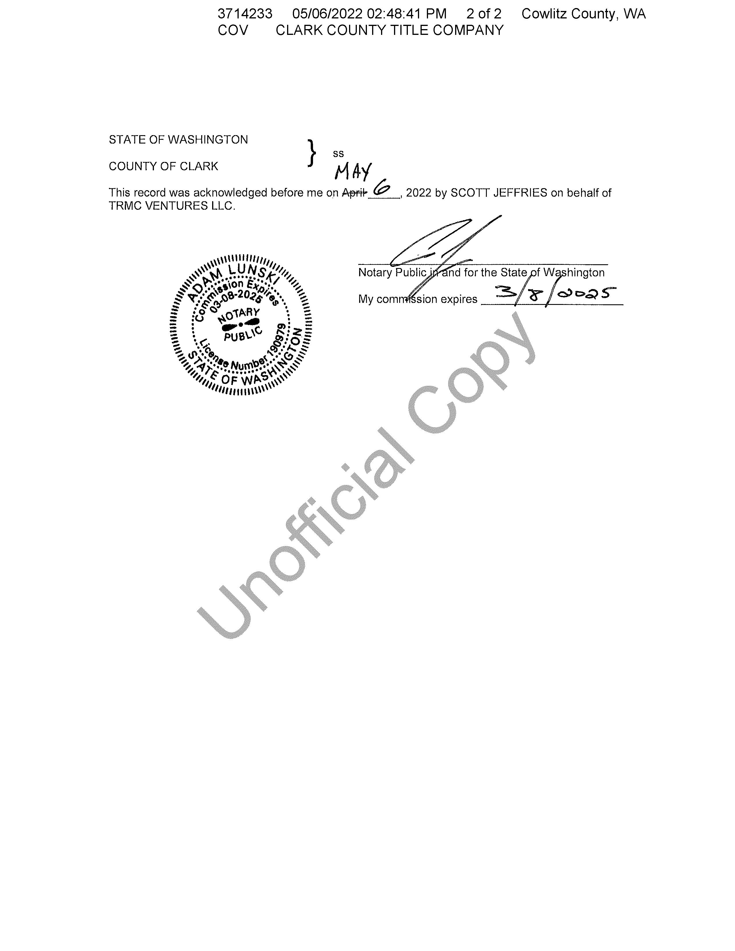
CHECKLIST
Purpose of checklist:
The State Environmental Policy Act (SEPA), Revised Code of Washington (RCW), Chapter 43.21C, requires all governmental agencies to consider the environmental impacts of a proposal before making decisions. An environmental impact statement (EIS) must be prepared for all proposals with significant adverse impacts on the quality of the environment. The purpose of this checklist is to provide information to help you and agencies identify impacts from your proposal and to help agencies decide whether or not an EIS is required.
Instructions for applicants:
This environmental checklist asks you to describe basic information about your proposal. Governmental agencies use this checklist to determine whether or not the environmental impacts of your proposal are significant. Please answer the questions briefly, giving the most precise information or best description known. In most cases, you should be able to answer the questions from your own observations or project plans without the need to hire experts. If you do not know the answer, or if a question does not apply to your proposal, write “do not know” or “does not apply.”
Some questions pertain to governmental regulations such as zoning, shoreline, and landmark designations. If you have problems answering these questions, please contact the Clark County Permit Center for assistance.
The checklist questions apply to all parts of your proposal, even if you plan to do them over a period of time or on different parcels of land. Attach any additional information that will help describe your proposal or its environmental effects. You may be asked to explain your answers or provide additional information related to significant adverse impacts.
Use of checklist for non-project proposals: Complete this checklist for non-project proposals (e.g., county plans and codes), even if the answer is “does not apply.” In addition, complete the supplemental sheet for non-project actions (Part D).
For non-project actions, the references in the checklist to the words “project,” “applicant,” and “property or site” should be read as “proposal,” “proposer,” and “affected geographic area,” respectively.
SEPA Environmental checklist (WAC 197-11-960) July 2016 Page 1 of 13
SEPA ENVIRONMENTAL
A. Background
1. Name of proposed project, if applicable: Ridge View Subdivision
2. Name of Applicant: TRMC VENTURES LLC
3. Address and Phone Number of Applicant and Contact Person: Address: PO Box 570 Phone Number: 360.952.8256
Woodland, WA 98674 E-Mail: pjeffries3@outlook.com
Contact Person: Patrick Jeffries scottj@jcllcwa.co
4. Date Checklist Prepared: September 9, 2022
5. Agency Requesting Checklist: Cowlitz County, WA
6. Proposed Timing or Schedule (including phasing, if applicable):
Development of the single-family residential lots is anticipated to commence upon attainment of requisite permitting and approvals. Project completion will be contingent on the timing of materials, supplies and obtaining the requisite building permitting and approvals.
7. Do you have any plans for future additions, expansion, or further activity related to this proposal? If yes, explain.
Future development of Lots 11 and 12 are possible but there are no actual plans for development at this time.
8. List any environmental information that has been or will be prepared related to this proposal.
• Traffic Impact Study dated August 22, 2022, prepared by Global Transportation Engineering Corporation.
• Critical Area Report dated June 24, 2022, prepared by Cascadia Ecological Services, Inc.
9. Do you know whether applications are pending for governmental approvals of other proposals directly affecting the property covered by your proposal? If yes, explain. No.
10. List any government approvals or permits needed for your proposal, if known: The following are the governmental approvals and permits anticipated for this proposal:
Preliminary Subdivision Approval Septic Permit Approval
SEPA Threshold Determination
Private Roadway Covenant
Erosion Control Plan Approval
Grading Permit
Stormwater Plan Approval
Final Plat Approval
Fire Marshal Site Plan Approval
Engineering Plan Approval
Grading Plan Approval
Building Permits
Final Subdivision Approval
NPDES Construction Stormwater Permit
The future development of both Lot 11 and 12 will necessitate site plan review. In addition, the future development of Lot 12 will necessitate a WSDOT Highway Access Permit as well as a CARA permit. Future development of Lot 11 will necessitate environmental review due to the presence of riparian habitat indicators.
11. Give brief, complete description of your proposal, including the proposed uses and the size of the project and site. There are several questions later in this checklist that ask you to describe certain aspects of your
State Environmental Policy Act (SEPA) Checklist SEPA Environmental checklist (WAC 197-11-960) July 2016 Page 2 of 13
proposal. You do not need to repeat those answers on this page. (Lead agencies may modify this form to include additional specific information on project description.)
The Applicant is requesting approval for a subdivision involving eleven (11) single-family residential lots and a commercial lot (Lot 12) within approximately 3.98 acres of real property Unzoned (UZ) property fronting State Route (SR) 504 and Sci Town Road, a County road. This proposal is located within parcel no.
WK3616002 A private roadway, utilities and other related infrastructure improvements are also included with this proposal All existing vegetation will be removed at the time of construction.
12. Location of the proposal. Give sufficient information for a person to understand the precise location of your proposed project, including a street address, if any, and section, township, and range, if known. If a proposal would occur over a range of area, provide the range or boundaries of the site(s). Provide a legal description, site plan, vicinity map, and topographic map, if reasonably available. While you should submit any plans required by the agency, you are not required to duplicate maps or detailed plans submitted with any permit applications related to this checklist.
The Site is located within Section 36, Township 10 North, Range 2 East of the Willamette Meridian.
B. Environmental Elements
1. Earth
a. General description of the site (circle one): Flat, rolling, hilly, steep slopes, mountainous, other
b. What is the steepest slope on the site (approximate percent slope)?
The steepest slope on the Site ranges between 40-45% according to information available from the County’s GIS in addition to topographical elevations obtained in July 2022 by Standridge Inc.
c. What general types of soils are found on the site (for example, clay, sand, gravel, peat, muck)? If you know the classification of agricultural soils, specify them and note any agricultural land of long-term commercial significance and whether the proposal results in removing any of these soils.
The Cowlitz County Soil Survey designates Site soils as predominantly Olympic silt loam, 20 to 30 percent slopes Other soils present at the site include Olympic silt loam, 2 to 8 percent slopes, Lithic Haplumbrepts, 50 to 100 percent slopes and Godfrey silt loam, 0 to 3 percent slopes
The Site does not contain soil types associated with agriculture
d. Are there surface indications or history of unstable soils in the immediate vicinity? If so, please describe. No.
e. Describe the purpose, type, and approximate quantities of any filling or proposed grading. Also, indicate the source of fill.
Grading will be performed as necessary for the installation of infrastructure and construction of the private road and lots associated with this twelve (12) lot rural subdivision. There will be approximately 36,000 cubic yards of excavation within a total disturbed area of 4.82-acres. The source of any required fill will be from on-site.
f. Could erosion occur as a result of clearing, construction, or use? If so, please describe.
As with any clearing or other types of earth-disturbing construction activity, there is potential for erosion to occur. Site-specific best management practices will be used to mitigate erosion during the construction of the Project. Site-specific erosion control measures will be implemented per the approved Grading Plan
State Environmental Policy Act (SEPA) Checklist SEPA Environmental checklist (WAC 197-11-960) July 2016 Page 3 of 13
Further, all sediment and erosion control design work will be completed in accordance with the requirements of the Construction Stormwater General Permit and County standards.
g. About what percent of the site will be covered with impervious surfaces after project construction (for example, asphalt or buildings)?
Approximately three percent (3%) of the site will be covered with impervious surfaces after the project is constructed. This equates to approximately 0.47 acres for the private roadway pavement, approximately 0.57 acres for the single-family residential lots It should be noted that the impervious areas are estimates only based on anticipated building envelopes; the Applicant does not at this time have site plans for Lot 11 or Lot 12. Final impervious surface area will be determined during the building permit review process
h. Proposed measures to reduce or control erosion, or other impacts to the earth include, if any:
Proposed measures to reduce or control erosion, or other impacts to the earth include treating and detaining stormwater, as well as, silt fencing and other erosion control best management practices. Forthcoming stormwater and erosion control plans prepared by Standridge Inc. comply with the County’s regulatory requirements.
2. Air
a. What types of emissions to the air would result from the proposal during construction operation, and maintenance when the project is completed? If any, generally describe and give approximate quantities if known.
During Construction, Operation, and Maintenance: Equipment and vehicles required for construction activities will generate dust and particulate emissions during the construction period.
After Project Completion: Delivery trucks, mail delivery, solid waste, recycling vehicles and residence’s automobiles will generate some particulate emissions in the long-term. Other emission sources include those typical to residential areas, e.g. small power tools including, heating, air conditioning, fireplaces, gas appliances, small gas-powered equipment used for site and landscape maintenance and emissions that are typical of a residential area are anticipated.
b. Are there any off-site sources of emissions or odor that may affect your proposal? If so, please describe. No.
c. Proposed measures to reduce or control emissions or other impacts to air? If so, generally describe. If necessary, water will be utilized for dust control as needed during construction of on- and off-site improvements. Emissions control measures for vehicles and equipment are regulated under the Washington State Department of Ecology and U.S. Environmental Protection Agency It is anticipated that all construction vehicles and equipment will be in compliance with these regulations.
3. Water
a. Surface Water:
1) Is there any surface water body on or in the vicinity of the site (including year-round and seasonal streams, saltwater, lakes, ponds, and wetlands)? If yes, describe the type and provide names and into which stream or river it flows into.
State Environmental Policy Act (SEPA) Checklist SEPA Environmental checklist (WAC 197-11-960) July 2016 Page 4 of 13
Salmon Creek, a Type F stream, transects a portion of the northeastern property from east to west. An unnamed Type N stream is crosses part of the western property, which converges off-site to the north with Salmon Creek. For more information, see the Critical Area Report dated June 24, 2022, prepared by Cascadia Ecological Services, Inc.
2) Will the project require any work within 200 feet of the described waters? If yes, please describe and attach available plans.
Work within two hundred feet (200’) of the described waters will occur in accordance with the approved critical area plan and permit and as such will not encroach within the areas forbidden within the recorded restrictive covenant
3) Estimate the amount of fill and dredge material that would be placed in or removed from surface water or wetlands and indicate the area of the site that would be affected. Indicate the source of fill material.
Not applicable.
4) Will the proposal require surface water withdrawals or diversions? Give general description, purpose, and approximate quantities if known.
Surface water withdrawals or diversions are not included with this proposal.
5) Does the proposal lie within a 100-year floodplain? If so, please note the location on the site plan. The proposal is not located within a 100-year floodplain.
6) Does the proposal involve any discharges of waste materials to surface waters? If so, describe the type of waste and anticipated volume of discharge. No. The proposal does not involve discharges of waste materials to surface waters.
b. Ground Water:
1) Will groundwater be withdrawn from a well for drinking water or other purposes? If so, give a general description of the well , proposed uses and approximate quantities withdrawn from the well. Will water be discharged to groundwater? Give general description, purpose, and approximate quantities if known.
Not applicable: Water will not be discharged to ground water.
2) Describe waste material that will be discharged into the ground from septic tanks or other sources, if any (for example: Domestic sewage; industrial, containing the following chemicals ... ; agricultural; etc.). Describe the general size of the system, the number of such systems, the number of houses to be served (if applicable), or the number of animals or humans the system(s) are expected to serve. Waste materials will be discharged into the ground from septic tanks for each of the single-family residential lots.
c. Water runoff (including stormwater):
1) Describe the source of runoff (including storm water) and method of collection and disposal. Include quantities, if known. Describe where water will flow, and if it will flow into other water. Post-development sources of runoff will include roofs, driveways and the private roadway. The existing impervious surfaces included in the northern commercial lot will remain as no development of that lot is currently contemplated.
Stormwater generated post-development will be collected, treated and released in accordance with the 2019 Western Washington Stormwater Manual and will include the provision of vegetated roadside
State Environmental Policy Act (SEPA) Checklist SEPA Environmental checklist (WAC 197-11-960) July 2016 Page 5 of 13
ditches with conveyance channels to existing roadside ditches and downspouts for single-family roofs Controlled disbursement will be facilitated by the inclusion of several hundred feet of spacing within which naturally vegetated areas must be crossed prior to the eventual discharge to Salmon Creek and the unnamed tributary within the southeastern portion of the site Eventual discharge of collected, disbursed and treated stormwater will go to the existing stream north of the development A preliminary stormwater technical information report (TIR) is not included in this proposal as it is a subdivision which includes less than an acre of impervious surface area. Pursuant to Section 16.20.070, the TIR is not required to be provided
Eventual discharge for on-site stormwater will be to Salmon Creek and its unnamed Type Ns tributary transecting the site in the southeastern corner.
2) Could waste materials enter ground or surface waters? If so, please describe. No.
d. Proposed measures to reduce or control surface, ground, and runoff water impacts, if any: This proposal will meet or exceed the County’s water quality and quantity standards provided for by its Stormwater Manual and Ordinance.
4. Plants
a. Check the types of vegetation found on the site:
▪ Deciduous Tree: alder, maple, aspen, other (poplar, apple and beaked hazelnut)
▪ Evergreen tree: fir, cedar, pine, other
▪ Shrubs
▪ Grass
▪ Pasture
▪ Crop or grain
▪ Wet soil plants: cattail, buttercup, bullrush, skunk cabbage, other
▪ Water plants: water lily, eelgrass, milfoil, other
▪ Other types of vegetation.
b. What kind and amount of vegetation will be removed or altered? All vegetation is proposed to be removed within the developed area of the site.
c. List threatened or endangered species on or near the site. There are no known threatened or endangered species known to be on or near the site.
d. Proposed landscaping, use of native plants, or other measures to preserve or enhance vegetation on the site, if any: No landscaping is included or required with this proposal.
e. List all noxious weeds and invasive species known to be on or near the site. None known.
5. Animals
a. List any birds and other animals which have been observed on or near the site or are known to be on or near the site.
State Environmental Policy Act (SEPA) Checklist SEPA Environmental checklist (WAC 197-11-960) July 2016 Page 6 of 13
▪ Birds: hawk, heron, eagle, songbirds, other;
▪ Mammals: deer, bear, elk, beaver, other; and,
▪ Fish: bass, salmon, trout, herring, shellfish, other (frog spp)
b. List any threatened or endangered species known to be on or near the site. There are no known threatened or endangered species known to be on or near the site The Type F stream may include habitat for anadromous fish such as rainbow trout, but its potential for salmon is unknown at this time.
c. Is the site part of a migration route? If so, explain. The site is located within what is commonly referred to as the Pacific Flyway. This Flyway is the general migratory route for various species of ducks, geese, and other migratory waterfowl. The Flyway stretches from Alaska to Mexico and from the Pacific Ocean to the Rocky Mountains. Neotropical birds, such as Robins, may also seasonally utilize or be near the Site.
d. List proposed measures to preserve or enhance wildlife, if any: Retaining a majority of the single-family residential lots as undisturbed area will provide some habitat for wildlife at the site.
e. List any invasive animal species known to be on or near the site. None.
6. Energy and Natural Resources
a. What kinds of energy (electric, natural gas, oil, wood stove, solar) will be used to meet the completed project's energy needs? Describe whether it will be used for heating, manufacturing, etc. Typical residential uses of electricity and/or natural gas will be required for the completed project.
b. Would your project affect the potential use of solar energy by adjacent properties? If so, generally describe. No.
c. What kinds of energy conservation features are included in the plans of this proposal? List other proposed measures to reduce or control energy impacts, if any: All construction on the site will be designed to comply with the State of Washington Energy Code and the adopted version of the International Building Code
7. Environmental Health
a. Are there any environmental health hazards, including exposure to toxic chemicals, risk of fire and explosion, spill, or hazardous waste that could occur as a result of this proposal? If so, describe. No environmental health hazards or hazardous waste are anticipated to result from this proposal
1) Describe any known or possible contamination at the site from present or past uses. Unknown.
2) Describe existing hazardous chemicals/conditions that might affect project development and design. This includes underground hazardous liquid and gas transmission pipelines located within the project area and in the vicinity.
State Environmental Policy Act (SEPA) Checklist
Environmental checklist (WAC 197-11-960) July 2016 Page 7 of 13
SEPA
The Applicant will comply with applicable local, state and federal regulations during the construction this proposal
3) Describe any toxic or hazardous chemicals that might be stored, used, or produced during the project's development or construction , or at any time during the operating life of the project. Construction equipment will require the use of various petroleum products for fuel, hydraulics, and lubrication.
4) Describe special emergency services that might be required. Special emergency services are not anticipated for this proposal. However, State-compliant protocol will be followed should any unforeseen complications arise with the spillage of hazardous or otherwise toxic chemicals. A spill prevention and/or response plan will be on site at all times during construction.
5) Proposed measures to reduce or control environmental health hazards, if any: None
b. Noise
1) What types of noise exist in the area which may affect your project (e.g., traffic, equipment, operation, other)?
Some traffic noise from surrounding roadways may be heard from the site but is not anticipated to adversely affect the proposal or surrounding area
2) What types and levels of noise are associated with the project on a short-term or a long-term basis (e.g., traffic, construction, operation, other)? Indicate what hours the noise would come from the site. Construction on the site will create short-term noise and will not occur after 7 p.m. or before 7 a.m. Visitor, resident, mail delivery, deliveries and solid waste and recycling vehicles will create some noise in the long-term. Other long-term noise sources include small power tools including, but not limited to, small gas-powered equipment used for site and landscape maintenance.
3) Proposed measures to reduce or control noise impacts, if any: Limiting construction activities between 7 a.m. and 7 p.m.
8. Land and Shoreline Use
a. What is the current use of the site and adjacent properties? Will the proposal affect current land uses on nearby or adjacent properties? If so, describe.
The site is currently vacant with a previously developed, flat, graveled area and remnants of old Spirit Lake Highway and a rock quarry located between the creek and SR-504. There are no existing structures on the site. The current use of adjacent properties includes undeveloped forested area and single-family residential housing. The proposal will not affect the nearby or adjacent properties.
b. Has the project site been used as working farmlands or working forest lands? If so, describe. How much agricultural or forest land of long-term commercial significance will be converted to other uses as a result of the proposal, if any? If resource lands have not been designated, how many acres in farmland or forest land tax status will be converted to nonfarm or nonforest use?
The project site was previously used for commercial timber production, but has not been designated Department of Forestry Land (DFL) or effectively managed for timber for many years.
State Environmental Policy Act (SEPA) Checklist SEPA Environmental checklist (WAC 197-11-960) July 2016 Page 8 of 13
1) Will the proposal affect or be affected by surrounding working farm or forest land normal business operations, such as oversize equipment access, the application of pesticides, tilling , and harvesting? If so, how: No.
c. Describe any structures on the site. There are no existing structures on the site.
d. Will any structures be demolished? If so, please describe. Not applicable. There are no existing structures on site.
e. What is the current zoning classification of the site? The site is designated as Unzoned (UZ) by Cowlitz County.
f. What is the current comprehensive plan designation of the site? Rural.
g. If applicable, what is the current shoreline master program designation of the site? Not applicable. The site is not located within a shoreline designated area.
h. Has any part of the site been classified as an "environmentally sensitive" area? If so, please specify. The County has designated riparian habitat area (RHA) on site associated with the streams as critical area. In addition, there are County mapping indicators for critical aquifer recharge area (CARA) within a small portion of the northern part of the property in proposed Lot 12
i. Approximately how many people would reside or work in the completed project?
Approximately twenty-eight (28) people would reside in the completed project. The figure was derived from multiplying the total number of proposed lots (10) by 2.8 (persons per single family household); this is the State of Washington Department of Ecology’s (ECA) standard calculation for occupancy rates utilized in instances when the exact number is not yet known.
j. Approximately how many people would the completed project displace? None.
k. Proposed measures to avoid or reduce displacement impacts, if any: Not applicable. The site is currently undeveloped and uninhabited.
l. Proposed measures to ensure the proposal is compatible with existing and projected land uses and plans, if any:
This proposal includes uses compatible with adjacent land use and with the County’s Comprehensive Plan.
m. Proposed measures to reduce or control impacts to agricultural and forest lands of long-term commercial significance, if any:
Not applicable. There are no anticipated impacts to agricultural and forest land of long-term commercial significance associated with this proposal.
9. Housing
a. Approximately how many units would be provided? Indicate whether it’s high, middle, or low-income housing.
State Environmental Policy Act (SEPA) Checklist SEPA Environmental checklist (WAC 197-11-960) July 2016 Page 9 of 13
Approximately ten (10) middle-income housing units will be provided
b. Approximately how many units, if any, would be eliminated? Indicate whether it’s high, middle, or lowincome housing.
No units will be eliminated with this proposal as the site is undeveloped.
c. List proposed measures to reduce or control housing impacts, if any: All residences will be built to code and impact fees will be paid.
d. How many people would reside or work in the completed project?
Approximately twenty-eight (28) people may reside in the completed project. However, the exact number of future residents is unknown at this time.
10. Aesthetics
a. What is the tallest height of any proposed structure(s), not including antennas? What is proposed as the principal exterior building materials?
No structures are included with this rural subdivision land use application However, the future development will require that principal exterior building materials are be selected to fit in with the surrounding area.
b. What views in the immediate vicinity would be altered or obstructed?
Views observable from the part of Si Town Road that abut site will be altered as a portion of the existing site vegetation will be replaced with a subdivision which includes single-family residential homes. However, most of the site will remain unaltered which will result in minimal change in views observable from Si Town Road.
c. Proposed measures to reduce or control aesthetic impacts, if any: None.
11. Light And Glare
a. What type of light or glare will the proposal produce? What time of day would it mainly occur?
Typical residential home lighting will be visible during the nighttime hours. At this time, the Applicant does not have development plans for Lots 11 and 12
b. Could light or glare from the finished project be a safety hazard or interfere with views?
No. The installation of illuminated materials will be done in such a way to minimize dispersion off-site and to not constitute a safety hazard.
c. What existing off-site sources of light or glare may affect your proposal?
None. Existing off-site sources of light or glare are not anticipated to be visible from the site as it is located at a distance where this would not be easily discernable.
d. Proposed measures to reduce or control light and glare impacts, if any: Should lighting be required, outside lighting will be down shielded to minimize dispersion and control for potential off-site impacts.
State Environmental Policy Act (SEPA) Checklist SEPA Environmental checklist (WAC 197-11-960) July 2016 Page 10 of 13
12. Recreation
a. What designated and informal recreational opportunities are in the immediate vicinity? Silver Lake is located approximately four (4) to five (5) miles to the east of the site.
b. Would the project displace any existing recreational uses? If so, describe. No.
c. Proposed measures to reduce or control impacts on recreation, including recreational opportunities to be provided by the project or applicant, if any: None.
13. Historic and Cultural Preservation
a. Are there any buildings, structures, or sites, located on or near the site that are over 45 years old listed in or eligible for listing in national, state, or local preservation registers ? If so, specifically describe. No.
b. Are there any landmarks, features, or other evidence of Indian or historic use or occupation? This may include human burials or old cemeteries. Are there any material evidence, artifacts, or areas of cultural importance on or near the site? Please list any professional studies conducted at the site to identify such resources. No.
c. Describe the methods used to assess the potential impacts to cultural and historic resources on or near the project site. Examples include consultation with tribes and the department of archeology and historic preservation, archaeological surveys, historic maps, GIS data, etc. Visual observation.
d. Proposed measures to avoid, minimize, or compensate for loss, changes to, and disturbance to resources. Please include plans for the above and any permits that may be required.
In the event any archaeological or historic materials are encountered during project activity, work in the immediate area must stop and the following actions taken:
1. Implement reasonable measures to protect the discovery site, including any appropriate stabilization or covering; and
2. Take reasonable steps to ensure the confidentiality of the discovery site; and,
3. Take reasonable steps to restrict access to the site of discovery
If human remains are uncovered, appropriate law enforcement agencies shall be notified first, and the above steps followed. If remains are determined to be Native, consultation with the effected Tribes will take place in order to ensure the culturally appropriate final disposition of said remains.
14. Transportation
a. Identify the public streets and highways serving the site and describe proposed access to the existing street system. Show on site plans, if any.
Lot 12 has been designed to include access to SR-504. Lot 11 has been designed to include access to Si Town Road. The single-family residential lots will be accessed via a private roadway which connects to Si Town Road. For more information see the land use plans that are included in the Application Submittal Item No. 7.
State Environmental Policy Act (SEPA) Checklist
July 2016 Page 11 of 13
SEPA Environmental checklist (WAC 197-11-960)
b. Is the site or affected geographic area currently served by public transit? If so, generally describe. If not, what is the approximate distance to the nearest transit stop?
The site is not currently served by public transit. The nearest transit stop is located approximately two (2) to three (3) miles away from the site.
c. How many additional parking spaces would the completed project or non-project proposal have? How many would the project or proposal eliminate?
This proposal has been designed to facilitate the inclusion of parking spaces within the single-family residential lots as well as the commercial lot There is currently no plan for development and accompanying site plans for Lot 11 and 12, therefore the number of parking spaces for these lots is presently zero No parking spaces will be eliminated with this proposal as the site is undeveloped.
d. Will the proposal require any new or improvements to existing roads, streets, pedestrian, bicycle or state transportation facilities, not including driveways? If so, generally describe (indicate whether public or private).
This proposal includes the provision of a new private roadway to serve the single-family residential lots. No improvements to public roadways are anticipated to be required for this proposal.
e. Will the project or proposal use (or occur in the immediate vicinity of) water, rail, or air transportation? If so, generally describe. No.
f. How many vehicular trips per day would be generated by the completed project or proposal? If known, indicate when peak volumes would occur and what percentage of the volume would be trucks (such as commercial and non passenger vehicles). What data or transportation models were used to make these estimates?
Based on the proposed development, it is estimated that full build out will generate approximately 72 new Average Daily Trips (ADTs) for the single-family residential lots on the adjacent roadway system during a typical weekday, including eight (8) total vehicle trips during the AM peak hours and a total of eleven (11) vehicle trips during the PM peak hours This estimate is derived from the traffic profile that was prepared based on the 11th ITE Trip Generation Manual and the proposed development’s distance from the nearest transportation corridors or intersections of regional significance. The results of the traffic profile indicate the property can be fully developed as proposed while maintaining acceptable levels of service and safety at the site access points. For more information, see the Traffic Impact Study included within Application Submittal Item No. 12.
g. Will the proposal interfere with, affect or be affected by the movement of agricultural and forest products on roads or streets in the area? If so, generally describe.
No.
h. Proposed measures to reduce or control transportation impacts, if any: Pay traffic impact fees and construct roadways per County requirements for final engineering approval.
15. Public Services
a. Would the project result in an increased need for public services (for example: fire protection, police protection, public transit, health care, schools, other)? If so, generally describe. Yes, there could be a potential need for additional fire / emergency and police protection with the proposed development
State Environmental Policy Act (SEPA) Checklist SEPA Environmental checklist (WAC 197-11-960) July 2016 Page 12 of 13
b. Proposed measures to reduce or control direct impacts on public services, if any: Provide urban utilities, pay taxes, system development charges and impact fees
16. Utilities
a. Circle the utilities currently available at the site: electricity, natural gas, water, refuse service, telephone, sanitary sewer, septic system, other (internet).
b. Describe the utilities that are proposed for the project, the utility providing the service, and the general construction activities on the site or in the immediate vicinity which might be needed. Public water lines, as well as septic is included with this proposal. Cowlitz County is the purveyor of the water utility located within Si Town Road. Water utility extensions will be required to facilitate the provision of water to each house. General construction activities related to the water line installation includes grading, trenching, installation of water lines and stabilization. On-site septic will be constructed within each lot, involving the excavation of soil, installation of the septic tank and site stabilization
Electricity and internet available to the site. Purveyors of electricity is presumed to be Cowlitz PUD and internet is presumed to be Comcast.
C. Signature
The above answers are true and complete to the best of my knowledge. I understand that the lead agency is relying on them to make its decision.
Signature:
Name of Signee: Ingrid Friedberg
Position and Agency/Organization: Land Use Planner, Standridge, Inc.
Date Submitted: September 9, 2022
Environmental Policy Act (SEPA) Checklist SEPA Environmental checklist (WAC 197-11-960) July 2016 Page 13 of 13
State
Turner, Daniel
From: Fornes, George L (DFW) <George.Fornes@dfw.wa.gov>
Sent: Wednesday, November 23, 2022 1:29 PM
To: Turner, Daniel
Subject: Cowlitz County SEPA Notification Permit #0002874-002
Attachments: Figure 5 of Cascadia Report from IAR Materials_Rural Subdivision 2270.02_TRMC_102 Si Town Rd.pdf
Mr. Turner,
Thank you for providing the Washington Dept of Fish & Wildlife (WDFW) opportunity to review this proposed land division at 102 Si Town Road in Castle Rock. As noted in the SEPA materials, Salmon Creek (Type F) crosses the eastern and northern portions of the property, and an unnamed Type N stream crosses the western portion of the property. Neither the SEPA materials nor the Proposed Site Plan show the third on-site stream that was identified within the Critical Areas Report authored by Cascadia Ecological Services, Inc. dated October 20, 2022. Figure 5 of the Cascadia report shows this third stream as a Type Ns water in the southeastern portion of the property, flowing northeast into Salmon Creek within the proposed Lot 11. The Proposed Site Plan is a good start in that it does show most of the streams, their associated riparian zones, and building envelopes that clearly avoid such areas. However WDFW recommends that the Proposed Site Plan and Preliminary Plat be revised such that they show all of the on-site streams as identified in the Cascadia report, along with their associated riparian zones and building envelopes. Figure 5 from the Cascadia report is attached here for your reference.
Current science regarding functional riparian zones is summarized in our new riparian management recommendations, Riparian Ecosystems, Volume 1: Science Synthesis and Management Implications (Quinn et al. 2020) and Riparian Ecosystems, Volume 2: Management Recommendations (Rentz et al. 2020). WDFW no longer has different recommended riparian zone widths for fish and non-fish bearing streams, and instead recognizes that a riparian zone width based on the Site Potential Tree Height of 200 years (SPTH200) will ensure that the riparian ecosystem has the greatest functionality regardless of stream type. In this framework, the functional riparian zone width within the subject property is 241 feet. Further, current science recommends having a minimum riparian zone of at least 100 feet for all streams regardless of stream Type, to help minimize pollutant runoff into streams. Please explore options to place the development a minimum of 100 feet or more from all on-site streams, and further than that (up to 241 feet) where possible.
WDFW recommends showing all on-site streams and their associated riparian zones on the face of the final plat, along with building envelopes for each lot that clearly avoid the riparian zones.
If any construction or maintenance of water crossing structures is proposed in order to access the new lots, the activity will require authorization from WDFW in the form of Hydraulic Project Approval (HPA).
You can find a tool for determining site potential tree height here: https://wdfw.maps.arcgis.com/apps/MapJournal/index.html?appid=35b39e40a2af447b9556ef1314a5622d
Our updated management recommendations for riparian areas are online here: https://wdfw.wa.gov/publications/01988
Thanks very much,
1
George Fornes Habitat Biologist
Washington Department of Fish and Wildlife
5525 S 11th Street, Ridgefield, WA 98642
Cell: (360) 623-0651
2
December 1, 2022
STATE OF WASHINGTON DEPARTMENT OF ECOLOGY

Southwest Region Office
PO Box 47775, Olympia, WA 98504-7775 • 360-407-6300
Daniel Turner, Community Planner
Cowlitz County
Department of Building & Planning
207 Fourth Avenue North #119
Kelso, WA 98626
Dear Daniel Turner:
Thank you for the opportunity to comment on the determination of nonsignificance for the TRMC Ventures, LLC, 102 Si Town Road, Preliminary Plat 2270.02 – 11-Lot Subdivision Project (0002874-003) as proposed by Standridge, Inc.. The Department of Ecology (Ecology) reviewed the environmental checklist and has the following comment(s):
SHORELANDS & ENVIRONMENTAL ASSISTANCE: Meghan Tait (360)-210-2783
Thank you for providing the Department of Ecology (Ecology) the opportunity to review the proposed 11-lot subdivision on parcel WK3616002.
The required mitigation sequencing for SEPA per WAC 197-11-768 is to avoid critical area impacts altogether by not taking certain actions, minimize impacts by limiting the degree of the action and its implementation, and then compensate for the impact. The creation of lots that are encumbered by wetland, stream, and their associated buffers does not allow for the required mitigation sequencing. Lots should be created to allow for avoidance of critical areas upon development. Proposed lot 11 is encumbered by critical areas and does not allow for the required mitigation sequencing.
The Cowlitz County Critical Areas Ordinance Reasonable Use Section 19.15.190(G)(4) states that “the allowance is not the result of action by current or previous property owners after the effective date of the ordinance codified in this section (e.g., creating new parcels without a feasible building site or means of access).” Lots created without feasible building sites or means of access outside of wetlands, streams, and their buffers, such as proposed lot 11, will not qualify for reasonable use allowance under these provisions.
For questions or technical assistance, contact the Wetland Specialist Meghan Tait via email, meghan.tait@ecy.wa.gov, or phone, 360-210-2783.
SOLID WASTE MANAGEMENT: Derek Rockett (360) 407-6287
All grading and filling of land must utilize only clean fill. All other materials may be considered solid waste and permit approval may be required from your local jurisdictional health department prior to filling. All removed debris resulting from this project must be
Daniel Turner
disposed of at an approved site. Contact the local jurisdictional health department or Department of Ecology for proper management of these materials.
WATER QUALITY/WATERSHED RESOURCES UNIT:
Brian Johnson (360) 624-5741
Erosion control measures must be in place prior to any clearing, grading, or construction. These control measures must be effective to prevent stormwater runoff from carrying soil and other pollutants into surface water or stormdrains that lead to waters of the state. Sand, silt, clay particles, and soil will damage aquatic habitat and are considered to be pollutants.
Any discharge of sediment-laden runoff or other pollutants to waters of the state is in violation of Chapter 90.48 RCW, Water Pollution Control, and WAC 173-201A, Water Quality Standards for Surface Waters of the State of Washington, and is subject to enforcement action.
Construction Stormwater General Permit: The following construction activities require coverage under the Construction Stormwater General Permit:
1. Clearing, grading and/or excavation that results in the disturbance of one or more acres and discharges stormwater to surface waters of the State; and
2. Clearing, grading and/or excavation on sites smaller than one acre that are part of a larger common plan of development or sale, if the common plan of development or sale will ultimately disturb one acre or more and discharge stormwater to surface waters of the State.
a) This includes forest practices (including, but not limited to, class IV conversions) that are part of a construction activity that will result in the disturbance of one or more acres, and discharge to surface waters of the State; and
3. Any size construction activity discharging stormwater to waters of the State that Ecology:
a) Determines to be a significant contributor of pollutants to waters of the State of Washington.
b) Reasonably expects to cause a violation of any water quality standard.
If there are known soil/ground water contaminants present on-site, additional information (including, but not limited to: temporary erosion and sediment control plans; stormwater pollution prevention plan; list of known contaminants with concentrations and depths found; a site map depicting the sample location(s); and additional studies/reports regarding contaminant(s)) will be required to be submitted. For additional information on contaminated construction sites, please contact Evan Wood at evan.wood@ecy.wa.gov, or by phone at (360) 706-4599.
Additionally, sites that discharge to segments of waterbodies listed as impaired by the State of Washington under Section 303(d) of the Clean Water Act for turbidity, fine sediment, high pH, or phosphorous, or to waterbodies covered by a TMDL may need to meet additional sampling and record keeping requirements. See condition S8 of the Construction Stormwater General Permit for a description of these requirements. To see if your site discharges to a TMDL or 303(d)-listed waterbody, use Ecology’s Water Quality Atlas at: https://fortress.wa.gov/ecy/waterqualityatlas/StartPage.aspx
December 1, 2022 Page 2
Daniel Turner
December 1, 2022
Page 3
The applicant may apply online or obtain an application from Ecology's website at: http://www.ecy.wa.gov/programs/wq/stormwater/construction/ - Application. Construction site operators must apply for a permit at least 60 days prior to discharging stormwater from construction activities and must submit it on or before the date of the first public notice.
Ecology’s comments are based upon information provided by the lead agency. As such, they may not constitute an exhaustive list of the various authorizations that must be obtained or legal requirements that must be fulfilled in order to carry out the proposed action.
If you have any questions or would like to respond to these comments, please contact the appropriate reviewing staff listed above.
Department of Ecology Southwest Regional Office
(GMP:202205775)
cc: Meghan Tait, SEA
Derek Rockett, SWM
Brian Johnson, WQ
SCHAFFRANRD SPIRITLAKEHWY S I T O W N R D B A R B A R D TIMBERLINE DR REYNOLDS RD G E N E V A L N A R V E S O N D R SCHAFFRANRD SPIRITLAKE HWY Co wli tz Co un ty ; 1 0 2 Si Town R oa d , Ca s tl e R oc k ; Pa rc e l# WK3 6 1 6 00 2 Legen d WK 36 1 60 02 0 425 850 1,275 1,700 212 .5 Fee t 8
SPIRIT LAKE HWY SITOWNRD TIMBERLINE DR REYNOLDS R D S I T OW N RD SPIRITLAKEHWY SPIRITLAKE HWY TIMBERLINE DR Co wli tz Co un ty ; 1 0 2 Si Town R oa d , Ca s tl e R oc k ; Pa rc e l# WK3 6 1 6 00 2 Legen d WK 36 1 60 02 0 150 300 450 600 75 Fee t 8
Preliminary Stormwater Report for Ridge View Subdivision
Date: February 25, 2023
Revised:
Applicant: TRMC Ventures LLC PO Box 570 Woodland, WA 98674
pjeffries3@outlook.com, scottj@jcllcwa.com
Prepared By: Standridge, Inc.

703 Broadway, Suite 610 Vancouver, Washington 98660 360.597.9240
Project: JCL001
This Technical Information Report and the data contained herein were prepared by the undersigned, whose seal, as a Professional Engineer licensed to practice as such, is affixed below. The proposed stormwater facilities are feasible and in compliance with Cowlitz County Code 16.20.070 and 18.50.
EXECUTIVE SUMMARY
Table of Contents
SECTION A – PROJECT OVERVIEW
A.1 Site Information………………………………………………………………….….….4
A.2 Determination of Applicable Minimum Requirements ....…….…...4
SECTION B – MINIMUM REQUIREMENTS
B.1 Preparation of Stormwater Site Plans……………………..…………….….5
B.2 Construction Stormwater Pollution Prevention Plans (SWPPP)….5
B.3 Source Control of Pollution………………………………………………….…….5
B.4 Preservation of Natural Drainage Systems and Outfalls……….…….5
B.5 On-site Stormwater Management BMPs……………………….……….….5
B.6 Runoff Treatment Analysis and Design…….…………….………………….6
B.7 Flow Control Analysis and Design………………….…….…………………….6
B.8 Wetlands Protection………………..………………………….…………………….7
B.9 Operations and Maintenance……………………….…………………………..7
SECTION C – SOILS EVALUATION …………………………………….………….7
SECTION D – SOURCE CONTROL .…………………………………….………….7
SECTION E – ONSITE STORMWATER MANAGEMENT BMPS ………….7
SECTION F – RUNOFF TREATMENT ANALYSIS AND DESIGN .………….7
SECTION G – FLOW CONTROL ANALYSIS AND DESIGN ….….………….7
SECTION H – WETLANDS PROTECTION …………………………….………….7
List of Tables
Table 1: Tax Lot Area Summary
Table 2: Impervious Area Summary
Table 3: Flow Summary
Figure 1: Site Map
List of Figures
Technical Appendices
Appendix A: Map Submittals
Appendix B: Existing Conditions Plan, Site Plan, Stormwater Plan
Appendix C: Geotechnical Report
Appendix D: Critical Area Report
Appendix E: WWHM Report (Bioretention Swale for treatment), HydroCAD Report (Santa Barbara Urban Hydrograph modeling for flow control)
Ridge View Subdivision
Technical Information Report

February 25, 2023
Page 3
EXECUTIVE SUMMARY
Ridge View Subdivision is a 10 lot residential and 1 lot commercial project within the Unzoned (UZ) property within Cowlitz County. The site is located at 102 Si Town Road in Castle Rock, Washington 98611 and is further identified as parcel number WK3613002. The site is 27.32 acres and proposes to use roadside swale to treat stormwater and a stormwater pond to meet detention requirements. Stormwater from the pond shall be conveyed in a roadside ditch where it will discharge to the existing Salmon Creek running through the site.
The project site utilizes the drainage requirements as outlined Cowlitz County Code, Chapter 16.20 (Stormwater Management in Rural Areas) Section 070 (Large Development Standards). As designed, water quality, quantity, and conveyance meet county standards.
Project Site =
Figure1:SiteMap
February 25, 2023
SECTION A – PROJECT OVERVIEW
A.1 Site Information
The site is located at 102 Si Town Road in Castle Rock, Washington 98611 and is further identified as parcel number WK3613002. The tax parcel is 32.92 acres per the county records with a 5.64 acre portion east of the existing Si Town Road and the remaining 27.28 acres west of Si Town Road. The 5.64 acre portion has been determined a separate legal lot of record and is not part of this project.
The site is sloping (10% - 33%) from a hilltop centrally located on the property with a natural surface flow to existing streams and roadside ditches that combine to a single threshold discharge area approximately 250 feet east of the property line in existing Salmon Creek. The site is undeveloped, with the central area recently logged (permit 0001643-001). There is an existing Type N stream along the west boundary of the parcel that connects to the existing Type F stream (Salmon Creek) that flows from east to west across the northern part of the site. A wetland east of Si Town Road as part of Salmon Creek and is upstream of this project site.
Proposed development consists of 10 residential lots south of Salmon Creek and associated utilities and roads. The development also consists of 1 commercial lot north of Salmon Creek and south of Spirit Lake Highway (SR504). See Table 1 below for tax lot area summary. A private road shall be constructed with the residential portion of the project along with roadside ditches, stormwater treatment swale, and a stormwater detention pond. This stormwater report shall address all requirements for the residential portion of this development. The commercial site shall be addressed with a separate site application when developed.
Plans showing the existing site, proposed site plan and drainage plan are located in Appendix B.
Table1:TaxLotAreaSummary
Pre-Developed Areas
A.2 Determination of Applicable Minimum Requirements
The proposed development is a new subdivision. As outlined in Cowlitz County Code 16.20.070 (Large development standards), all new subdivisions shall design and construct the development to satisfy minimum requirements No. 1 through No. 9 for the new, replaced, and converted impervious and pervious surfaces. All pollution generating impervious area will be captured and directed to a stormwater treatment swale and detention pond. The proposed new and replaced impervious surfaces total 51,720 SF for the residential development, see Table 2 on the next page.
Ridge View Subdivision
Technical Information Report
Page 4
Existing Si Town Road (ROW Dedication) 77,791 SF/ 1.79 AC East of Si Town Road Lot 245,671 SF/ 5.64 AC Commercial 182,039 SF/ 4.18 AC Residential (10 Lots) 928,325 SF/ 21.31 AC Total Project Site Area 1,433,826 SF/ 32.92 AC
February 25, 2023
Table2:ImperviousAreaSummary
SECTION B – MINIMUM REQUIREMENTS
B.1 Preparation of Stormwater Site Plans
Stormwater Plans and a Stormwater TIR have been prepared in conformance with the 2022 Cowlitz County Stormwater Drainage Manual (CCSDM) Chapter 3 and have been submitted with this application.
B.2 Construction Stormwater Pollution Prevention Plans (SWPPP)
A SWPPP shall be prepared for submittal with Final Plans and TIR.
B.3 Source Control of Pollution
There are no prohibited discharges that are proposed from the project. For protection during construction, an erosion control plan shall be included in the final plan submittal for permitting and provided to the contractor. The final site will collect all runoff from areas exposed to vehicular traffic in stormwater cartridges for treatment before discharge offsite.
B.4 Preservation of Natural Drainage Systems and Outfalls
The natural drainage of the site is overland from a central hilltop to an existing Type N stream to the west, to a roadside ditch to the east along Si Town Rd, and northerly towards an existing Type F stream (Salmon Creek). This pattern will continue, as the proposed private street will be caught in a roadside ditch, conveyed to a treatment swale and detention pond, and discharged to the existing Si Town Rd roadside ditch. Some roof stormwater runoff will flow overland to either the Type N stream or Salmon Creek. See Appendix D for critical area report.
B.5 Onsite Stormwater Management BMPs
Infiltration is not recommended by the Geotech, see Appendix C. The project will utilize a bioretention swale, dispersion, amended soil, and a detention pond to meet treatment and flow control requirements. Specifically, the site will use BMP T5.10B “Downspout Dispersion Systems”, BMP T5.13 “Post-Construction
Ridge View Subdivision
Technical Information Report
Page
5
Pre-Developed Areas Post-Developed Areas Hard Surface, NPG (Houses) 0 SF/ 0 AC 25,000 SF/ 0.57 AC Hard Surface, PGIS (Pavement, Driveways) 0 SF/ 0 AC 26,720 SF/ 0.61 AC Total Hard Surface 0 SF/ 0 AC 51,720 SF/ 1.19 AC Native Vegetation 928,325 SF/ 21.31 AC 825323 SF/ 18.95 AC Pervious Area (Grass, Roadside Ditches) 0 SF/ 0 AC 51,282 SF/ 1.18 AC Total Project Site Area 928,325 SF/ 21.31 AC 928,325 SF/ 21.31 AC Replaced Hard Surface - 0 SF/ 0 AC Retained hard Surface - 0 SF/ 0 AC Est. Area of Disturbance (Residential) - 103,002 SF/ 2.36 AC Est. Area of Disturbance (Commercial) - 114,737 SF/ 2.63 AC
Ridge View Subdivision
Technical Information Report
February 25, 2023
Page 6
Soil Quality and Depth”, and BMP T5.14B “Bioretention” as shown in Volume V-5.3.1 of the SWMMWW and detention ponds in Volume III-3.2.1.
Some Roof areas will utilize BMP T5.10B “Downspout Dispersion Systems”, while the remaining will be directed to a roadside ditch via downspout. BMP T5.14B “Bioretention” shall be utilized to treat road, driveway, and roof runoff not utilizing downspout dispersion. All disturbed pervious areas left uncovered after construction is complete will meet the minimum requirements of BMP T5.13 “Post-Construction Soil Quality and Depth”.
All stormwater quality and quantity facilities for the site have been designed in conformance with the 2022 CCSDM.
B.6 Runoff Treatment Analysis and Design,
The private street, driveways, roofs, and front yards that drain to the roadside ditch along the private street will be the only surfaces that require treatment. These areas total 88,949 SF, exceeding the 5,000 SF threshold. Basic stormwater treatment is required. A bioretention swale per BMP T7.30 shall provide treatment. The bioretention swale shall have side slopes not to be greater than 3H:1V, and made up of 18” of standard bioretention soil mix, 18” of clean drain rock, a 6” perforated underdrain pipe with a 3” orifice connected to a 6” riser pipe for overflow that is 2’ above the bioretention soil, and a 6” outlet pipe at the same elevation as the underdrain. The bioretention swale is designed to treat more than 91% of runoff, in conformance with Volume V of the 2019 SMMWW, 2022 CCSDM, and Cowlitz County Municipal Code Chapter 16.20. See Appendix E for WWHM treatment calculations.
B.7 Flow Control Analysis and Design
A detention system that consists of a detention pond and flow restrictor are proposed for the project to meet the flow control standards outlined in Cowlitz County Municipal Code Chapter 16.20.070. A detention pond shall have side slopes not to be greater than 3H:1V, flat bottom with 0.5-foot sediment storage, 5 feet in depth, flow control structure, and emergency overflow.
In the event the flow control clogs, the stormwater facility will overflow into the right-of way into a roadside ditch along Si Town Rd that conveys to Salmon Creek.
All stormwater quantity facilities for the site have been designed in conformance with Volume III of the 2019 SMMWW, 2022 CCSDM, and Cowlitz County Municipal Code Chapter 16.20. See Appendix E for HydroCAD flow control calculations.
Table3:FlowSummary
Pre-Developed Flows (cfs) Post-Developed Flows (cfs) 2-Year 0.98 0.48 (0.37 + 0.11) 25-Year 3.54 2.25 (1.48 + 0.77) 100-Year 6.52 6.39 (5.20 + 1.19)
Ridge View Subdivision
Technical Information Report
February 25, 2023 Page 7
B.8 Wetlands Protection
This project site does not discharge directly or indirectly to an existing wetland. There is an existing wetland upstream of the discharge location on the east side of Si Town Road and is outside the ground disturbance limits. See Appendix D for critical area report.
B.9 Operations and Maintenance
A site-specific Maintenance and Operation Manual will be included with the final approval submittal and will also be provided to the owner.
SECTION C – SOILS EVALUATION
Per the NRCS Soil Survey, the majority of the site is comprised of OmE - Olympic Silt Loam (3% to 30% slopes), which is considered well drained and moderately slowly permeable. Olympic Silt Loam is classified into Hydrologic Soil Group B. No high groundwater is present. Soil samples have been taken, but a geotechnical report is not yet completed. See Appendix C for preliminary geotechnical infiltration and subsurface conditions.
SECTION D – SOURCE CONTROL
See Minimum Requirements 3 – Section B.3
SECTION E – ONSITE STORMWATER MANAGEMENT BMPS
See Minimum Requirements 5 – Section B.5
SECTION F – RUNOFF TREATMENT ANALYSIS AND DESIGN
See Minimum Requirements 6 – Section B.6
SECTION G – FLOW CONTROL ANALYSIS AND DESIGN
See Minimum Requirements 7 – Section B.7
SECTION H – WETLANDS PROTECTION
See Minimum Requirements 8 – Section B.8
APPENDIX A
MAP SUBMITTALS: VICINITY MAP SOILS MAP

APPROXIMATELY 3.7MINEOF CASTLEROCK
INTERSTATE 5 CASTLEROCK
PROJECTLOCATION
N
VICINITYMAP:
Study
 148 - Olympic silt loam, 20 to 30 percent slopes
147 - Olympic silt loam, 8 to 20 percent slopes
Area
146 - Olympic silt loam, 2 to 8 percent slopes
147 - Olympic silt loam, 8 to 20 percent slopes
Source: USDA Web Soil Survey
148 - Olympic silt loam, 20 to 30 percent slopes
147 - Olympic silt loam, 8 to 20 percent slopes
Area
146 - Olympic silt loam, 2 to 8 percent slopes
147 - Olympic silt loam, 8 to 20 percent slopes
Source: USDA Web Soil Survey
EXISTING CONDITIONS PLAN SITE PLAN
STORMWATER PLAN
APPENDIX B
SPIRITLAKEHWY(SR504)
CLASSIVGENERALFOREST PRACTICESCONVERSION PERMIT-0001643-001
PARCELWJ0120015PARCELWJ0120013PARCELWJ0120011PARCELWJ0120009PARCELWJ0120007PARCELWJ0120005PARCELWJ0120003 PARCELWJ0120001 PARCEL WJ0101001
TIMBERLINEDR(EXIST)
SITOWNRD (EXIST)
PARCEL
WK3615004 PARCEL WK3615007
PARCEL
PARCEL
PORTIONOF PARCEL
SALMONCREEK 50'RHA PERDEED3714233 150'RHA PERDEED3714233 50'RHA BUFFER
PARCEL WF0620067
WK3616001
WK3614003
WK3616002
75' WSDOT ROW 75' WSDOT ROW 02 EXISTING CONDITIONS N SHEET P:\JCL001-SiTownSubdivision\5Planning\Drawings\JCL001-Existing.dwgFeb27,2023-2:35pm PREPARED BY: PROJECTNO.: JCL001 DESIGNBY: CDC REVIEWEDBY: LKS DATE: 02/27/2023 RIDGE VIEW SUBDIVISION COWLITZ COUNTY, WASHINGTON TRMC VENTURES LLC 18518 NW 41ST AVE RIDGEFIELD, WA 98642 SHEETSIZE: 0 SCALE:1"= 200 100 22x34 100' APPLICANT & OWNER: REV. DATE DESCRIPTION S TANDRIDGE M 703 Broadway St, Suite 610 Vancouver, WA 98660 PLANNING ENGINEERING SURVEYING WWW. S TANDRIDGE I NC.COM F 888.750.4981 O 360.597.9240 LEGEND DRAINAGEFLOWARROW
BOUNDARYLINE SHEETNOTES 1.EXISTINGCONTOURSSHOWNAT5FTINTERVALS. 2.DRONEIMAGEFEBRUARY3,2023.
EXISTINGCONTOUR(MAJOR)
SPIRITLAKEHWY(SR504)
SHEETNOTES
1. PRIVATEROADRIGHT-OF-WAYSHALLBE60'WIDE,WITH24'PAVEDWIDTH,ANDROADSIDE DITCHES.COWLITZCOUNTYHASNORESPONSIBILITYTOMONITOR,IMPROVE,ORMAINTAINTHE PRIVATEROADSCONTAINEDWITHINORPRIVATEROADSPROVIDINGACCESSTOTHEPROPERTY DESCRIBEDINTHISDEVELOPMENT.ANYPRIVATEACCESSDRIVEWAY,ROAD,ORSTREETSHALL REMAINAPRIVATERESPONSIBILITYUNLESSITISUPGRADEDTOAPUBLICSTREETORROAD STANDARDSATTHEEXPENSEOFTHEDEVELOPERORABUTTINGLOTOWNERSTOINCLUDEHARD SURFACEPAVINGANDISACCEPTEDBYTHECOUNTYFORPUBLICOWNERSHIPANDCONTINUED MAINTENANCE.
2. SETBACKSAREFRONT=25',SIDES=10',ANDREAR=15'
3. AMINIMUMOF100'WIDTHPROVIDEDATBUILDINGENVELOPE/PAD.
4.NOWATERMETERSSHALLBELOCATEDABOVEELEVATION630FT.NAVD88.
TIMBERLINEDR(EXIST)
LOT11(COMMERCIALPARCEL) LOT10 LOT9 LOT8 LOT7 LOT6 LOT5 LOT4 LOT3 LOT2 LOT1 SITOWNRD (EXIST)
PAD 584 PAD 575 PAD PAD 584 PAD=580 PAD=565 PAD 545 PAD=536 PAD 550 PAD 563 4.18AC 2.00AC 2.00AC 2.00AC 2.00AC 2.00AC 2.00AC 2.00AC 2.00AC 2.00AC 2.00AC TRACT"B" TRACT "A" 582 SALMONCREEK 50'RHA PERDEED3714233 150'RHA PERDEED3714233 15'REAR SETBACK (TYP) WILDWOODDR(PVT) 25'FRONT SETBACK(TYP) 10'SIDE SETBACK (TYP) 50'RHA BUFFER 75' WSDOT ROW 75' WSDOT ROW 100' WSDOTROW 60' 60' 100' RHA BUFFER 100' RHA BUFFER 30' 24' R50' R25' 115' 187' 109' 130' 112' 109' 100' 122' 129' 167' 50' RHA BUFFER 150' WETLAND BUFFER SALMONCREEK 100'RHA BUFFER 100'RHA BUFFER 125' R25' PORTIONOF PARCEL WK3616002 60.00' 12.00' RIGHTOFWAY 12.00' WILDWOODDR(PRIVATE) 1"=10' 2.5% 12.00' 6.00' 12.00' EDGEOF PAVEMENT 30.00' CL PROP LINE PROP LINE 2.5% 6.00' EDGEOF PAVEMENT 03 PROPOSED SITE PLAN N SHEET P:\JCL001-SiTownSubdivision\5Planning\Drawings\JCL001-SitePlan.dwgFeb27,20232:35pm PREPARED BY: PROJECTNO.: JCL001 DESIGNBY: CDC REVIEWEDBY: LKS DATE: 02/27/2023 RIDGE VIEW SUBDIVISION COWLITZ COUNTY, WASHINGTON TRMC VENTURES LLC 18518 NW 41ST AVE RIDGEFIELD, WA 98642 SHEETSIZE: 0 SCALE:1"= 200 100 22x34 100' APPLICANT & OWNER: REV. DATE DESCRIPTION S TANDRIDGE M 703 Broadway St, Suite 610 Vancouver, WA 98660 PLANNING ENGINEERING SURVEYING WWW. S TANDRIDGE I NC.COM F 888.750.4981 O 360.597.9240
SPIRITLAKEHWY(SR504)
LOT11(COMMERCIALPARCEL)
WILDWOODDR(PVT)
TIMBERLINEDR(EXIST)
SHEETNOTES
1. PRIVATEROADRIGHT-OF-WAYSHALLBE60'WIDE,WITH24'PAVEDWIDTH,ANDROADSIDE DITCHES.COWLITZCOUNTYHASNORESPONSIBILITYTOMONITOR,IMPROVE,ORMAINTAINTHE PRIVATEROADSCONTAINEDWITHINORPRIVATEROADSPROVIDINGACCESSTOTHEPROPERTY DESCRIBEDINTHISDEVELOPMENT.ANYPRIVATEACCESSDRIVEWAY,ROAD,ORSTREETSHALL REMAINAPRIVATERESPONSIBILITYUNLESSITISUPGRADEDTOAPUBLICSTREETORROAD STANDARDSATTHEEXPENSEOFTHEDEVELOPERORABUTTINGLOTOWNERSTOINCLUDEHARD SURFACEPAVINGANDISACCEPTEDBYTHECOUNTYFORPUBLICOWNERSHIPANDCONTINUED MAINTENANCE.
2. SETBACKSAREFRONT=25',SIDES=10',ANDREAR=15'
3. AMINIMUMOF100'WIDTHPROVIDEDATBUILDINGENVELOPE/PAD.
4.NOWATERMETERSSHALLBELOCATEDABOVEELEVATION630FT.NAVD88.
5. EXISTINGANDPROPOSEDCONTOURSSHOWNAT5FTINTERVALS.
LEGEND
DRAINAGEFLOWARROW EXISTINGCONTOUR(MAJOR)
PROPOSEDCONTOUR(MAJOR)
BOUNDARYLINE
LOT10 LOT9 LOT8 LOT7 LOT6 LOT5 LOT4 LOT3 LOT2 LOT1 SITOWNRD (EXIST)
PAD 584 PAD 575 PAD PAD 584 PAD=580 PAD=565 PAD 545 PAD=536 PAD 550 PAD 563 TRACT"B" TRACT "A" 582 SALMONCREEK 50'RHA PERDEED3714233 150'RHA PERDEED3714233
50'RHA BUFFER 75' WSDOT ROW 75' WSDOT ROW 100' WSDOTROW 100' RHA BUFFER 100' RHA BUFFER 50' RHA BUFFER 150' WETLAND BUFFER SALMONCREEK 100'RHA BUFFER 100'RHA BUFFER PORTIONOF PARCEL WK3616002 PROPOSEDPOND (BOTTOMAREA~1600SF) PROPOSEDBIORETENTIONSWALE WETLAND LOT7 PAD 584 HORIZONTALSCALE:1"=100' VERTICALSCALE:1"=25' WildwoodDr. 520 530 540 550 560 570 580 590 600 610 620 520 530 540 550 560 570 580 590 600 610 620 9+00 10+00 11+00 12+00 13+00 14+00 15+00 16+00 17+00 18+00 -3.32%2.00% 14.11% 4.00% 250.00'VC PVI14+79.00 PVIELEV578.500' HIGHPT.16+04.00 HIGHPT.ELEV583.5' G1=14.11%,G2=4.00% K=24.73 100.00'VC PVI11+23.07 PVIELEV528.285' LOWPT.10+73.07 LOWPT.ELEV527.285' G1=2.00%,G2=14.11% K=8.26 05 PROPOSED STORMWATER PLAN N SHEET P:\JCL001-SiTownSubdivision\5Planning\Drawings\JCL001-StormPlan.dwgFeb27,2023-2:35pm PREPARED BY: PROJECTNO.: JCL001 DESIGNBY: CDC REVIEWEDBY: LKS DATE: 02/27/2023 RIDGE VIEW SUBDIVISION COWLITZ COUNTY, WASHINGTON TRMC VENTURES LLC 18518 NW 41ST AVE RIDGEFIELD, WA 98642 SHEETSIZE: 0 SCALE:1"= 200 100 22x34 100' APPLICANT & OWNER: REV. DATE DESCRIPTION S TANDRIDGE M 703 Broadway St, Suite 610 Vancouver, WA 98660 PLANNING ENGINEERING SURVEYING WWW. S TANDRIDGE I NC.COM F 888.750.4981 O 360.597.9240
GEOTECHNICAL REPORT
APPENDIX C
Cody Cumpton
From: Tyler Pierce <tyler.pierce@nv5.com>
Sent: Monday, February 27, 2023 9:07 AM
To: Ingrid Friedberg
Cc: Laura Standridge; Cody Cumpton; Scott McDevitt; TRMCVENTUR-1-01
Subject: RE: Test Pit Locations for Ridge View Subdivision (102 Si Town Road) (JCL001)
Attachments: TRMCVentur-1-01.kmz; 2023-02-13-Geo test pit locations.pdf
Hi Ingrid,
We performed the infiltration testing on Friday. The results were a mixed bag. The test pit locations and names are shown on the attached site plan and the .kmz file. In general, we observed silt and clay overlying decomposed bedrock and eventually intact bedrock.
We were unable to test at TP‐2 because the groundwater was approximately 4 feet beneath the surface.
The infiltration rate at TP‐6 was approximately 0.
The infiltration rate at TP‐9 was 4 inches per hour.
Based on the varying test rates and the subsurface conditions, we recommend infiltration not be used as the sole source for stormwater management. If infiltration is used we would recommend a short‐term rate of no more than 1 in/hr and a factor of safety of at least 3 for the long‐term rate.
Let me know if you would like to discuss the results. We will start the lab testing this week and work on getting you the report as soon as possible.
Thanks,
GeoDesign is now NV5
Please note the new email address
Electronic Communications Disclaimer
From: Ingrid Friedberg <ingrid.friedberg@standridgeinc.com>
Sent: Tuesday, February 21, 2023 11:05 AM
To: Tyler Pierce <tyler.pierce@nv5.com>
Cc: Laura Standridge <laura@standridgeinc.com>; Cody Cumpton <cody.cumpton@standridgeinc.com>; Scott McDevitt <Scott.McDevitt@nv5.com>
Subject: RE: Test Pit Locations for Ridge View Subdivision (102 Si Town Road) (JCL001)
Hi Tyler,
Thank you very much for this preliminary information. We will let you know if we have follow‐up questions.
I’m grateful infiltration testing can occur on Friday. Please let me know if I can be of help with coordinating that.
1
Tyler Pierce, P.E.
| NV5 703 Broadway Street, Suite 650 | Vancouver, WA 98660 | Phone: 360.693.8416 | Direct: 503.726.3188 | Cell: 971.276.2323
| Senior Project Engineer
With thanks for your time and assistance,
Ingrid S. Friedberg
Land Use Planner Standridge Inc.
Planning | Civil Engineering | Surveying
Direct/Cell: 360.907.4529
Main Office: 360.597.9240
WBE Certified in Oregon and Washington
Federally DBE Certified
From: Tyler Pierce <tyler.pierce@nv5.com>
Sent: Tuesday, February 21, 2023 10:53 AM
To: Ingrid Friedberg <ingrid.friedberg@standridgeinc.com>
Cc: Laura Standridge <laura@standridgeinc.com>; Cody Cumpton <cody.cumpton@standridgeinc.com>; Scott McDevitt <Scott.McDevitt@nv5.com>
Subject: RE: Test Pit Locations for Ridge View Subdivision (102 Si Town Road) (JCL001)
Hi Ingrid,
As discussed on the phone, here are our preliminary recommendations based on a desktop review of sites in the area. Hopefully this helps and we will try to get you the report ASAP.
The subsurface conditions will likely consist of silt and clay near the existing ground surface. The clay and silt in the area appears stiff so foundations bearing on near surface silt and clay will likely have an allowable bearing capacity between 2,000 and 3,000 psf. The site is likely underlain by decomposed basalt which will consist of gravely silt and clay. If foundations are supported by decomposed basalt, the bearing capacity can be increased to 4,000 to 5,000 psf.
Unfortunately, the site likely won’t have very high infiltration rates, I would expect less than 1‐inch/hr for in the infiltration tests.
Let me know if you need any more info for now.
Thanks,
Tyler
GeoDesign is now NV5
Please note the new email address
Electronic Communications Disclaimer
From: Ingrid Friedberg <ingrid.friedberg@standridgeinc.com>
Sent: Monday, February 20, 2023 9:55 AM
To: Tyler Pierce <tyler.pierce@nv5.com>
Cc: Laura Standridge <laura@standridgeinc.com>; Cody Cumpton <cody.cumpton@standridgeinc.com>; Scott McDevitt <Scott.McDevitt@nv5.com>
Subject: RE: Test Pit Locations for Ridge View Subdivision (102 Si Town Road) (JCL001)
2
| NV5 703 Broadway Street, Suite 650 | Vancouver, WA 98660 | Phone: 360.693.8416 | Direct: 503.726.3188 | Cell: 971.276.2323
Pierce, P.E. | Senior Project Engineer
Hi Tyler,
Thank you for your email. We don’t think it makes sense for the proposed test pit for the commercial lot is an existing road. The proposed test pit location for Lot 1 looks fine to us
Please coordinate with the Jeffries for the excavation. We need to have everything submitted to Cowlitz County by March 1 and we need the Geotechnical Engineering Report for our preliminary hydrology report that is part of that March 1 submittal.
Please let me know if you have questions or require additional information.
With thanks for your time and assistance,
Ingrid S. Friedberg
Land Use Planner
Standridge Inc.
Planning | Civil Engineering | Surveying
Direct/Cell: 360.907.4529
Main Office: 360.597.9240
WBE Certified in Oregon and Washington
Federally DBE Certified
From: Tyler Pierce <tyler.pierce@nv5.com>
Sent: Monday, February 20, 2023 9:19 AM
To: Ingrid Friedberg <ingrid.friedberg@standridgeinc.com>
Cc: Laura Standridge <laura@standridgeinc.com>; Cody Cumpton <cody.cumpton@standridgeinc.com>; Scott McDevitt <Scott.McDevitt@nv5.com>
Subject: RE: Test Pit Locations for Ridge View Subdivision (102 Si Town Road) (JCL001)
Hi Ingrid,
Sorry that I am just getting to this now, I was out last week. After reviewing the proposed test pit locations, I would suggest moving at least one of the test pits form the residential area down to the commercial parcel. The residential loads will be very light compared to any commercial development and it would be best to have a little more info down in the commercial area. I revised a couple locations let me know if this looks acceptable?
I will contact public locates and work with the excavator to schedule a date to dig the test pits.
Thanks,
Tyler Pierce, P.E. | Senior Project Engineer | NV5 703 Broadway Street, Suite 650 | Vancouver, WA 98660 |
GeoDesign is now NV5
Please note the new email address
Electronic Communications Disclaimer
3
Direct:
Cell:
Phone: 360.693.8416 |
503.726.3188 |
971.276.2323
From: Ingrid Friedberg <ingrid.friedberg@standridgeinc.com>
Sent: Monday, February 13, 2023 5:27 PM
To: Tyler Pierce <tyler.pierce@nv5.com>
Cc: Laura Standridge <laura@standridgeinc.com>; Cody Cumpton <cody.cumpton@standridgeinc.com>
Subject: Test Pit Locations for Ridge View Subdivision (102 Si Town Road) (JCL001)
Hi Tyler,
Please see the attached for proposed test pit locations within the updated site layout.
With thanks for your time,
Ingrid S. Friedberg
Land Use Planner
Standridge Inc.
Planning | Civil Engineering | Surveying
Direct/Cell: 360.907.4529
Main Office: 360.597.9240
WBE Certified in Oregon and Washington
Federally DBE Certified
4
PROPOSEDCUL-DE-SAC (EXCAVATE~20FTFORTESTPIT)
PROPOSEDPOND (INFILTRATIONTEST)

P:\JCL001-SiTownSubdivision\5Planning\Drawings\xJCL001-Base.dwgFeb13,2023-9:19am SHEET PROPOSED GEOTECHNICAL SITE PLAN TEST PIT LOCATIONS RIDGE VIEW SUBDIVISION CASTLE ROCK, WASHINGTON N PROJECTNO.: JCL001 DESIGNBY: CDB REVIEWEDBY: LKS DATE: 02/13/2023 PREPARED BY: SCALE:1"= SHEETSIZE: 0 11x17 200 400 200 01 S TANDRIDGE M 703 Broadway St, Suite 610 Vancouver, WA 98660 PLANNING ENGINEERING SURVEYING WWW. S TANDRIDGE I NC.COM F 888.750.4981 O 360.597.9240
INFILTRATIONTEST LOCATION INFILTRATIONTEST LOCATION TESTPIT LOCATION TESTPIT LOCATION TESTPIT LOCATION
CRITICAL AREA REPORT
APPENDIX D
CRITICAL AREA REPORT
102 Si Town Road Rural Subdivision
102 Si Town Road, Castle Rock, WA 98611
Prepared by: Jim Barnes
Cascadia Ecological Services, Inc.

14205 NW 56th Avenue
Vancouver, WA 98685
(360) 601‐8631
Applicant: TMRC Ventures LLC
18518 NW 41st Avenue Ridgefield, WA 98642
pjeffries3@outlook.com
(360) 597‐5363
Date: June 24, 2022
Parcel WK3616002
Executive Summary
This report details the results of a critical areas report conducted by Cascadia Ecological Services, Inc. (CES) on behalf of the applicant, TMRC Ventures LLC, for Cowlitz County Parcel WK3616002. This report identifies the extent of critical areas identified on or in the immediate vicinity of the study area as defined and regulated by the Cowlitz County Critical Areas Ordinance (CAO).
The study area consists of one parcel of land, Parcel WK3616002, located in section 36, Township 5N, Range 2 West of the Willamette Meridian, Cowlitz County, Washington. The property is currently unzoned and the total site area of the property is approximately 32.92 acres.
During a site visit completed by Cascadia Ecological Services, Inc. (CES) staff on June 14, 2022, it was determined that two streams are present on the property. Salmon Creek, a DNR Type F water, outlets onto the northeast portion of the site and flows from east to west along the north part of the site. An unnamed Type N stream crosses onto the southwest corner of the property and flows north for approximately 280 feet before flowing off‐site onto the adjacent parcel to the west. This stream converges with Salmon Creek to the northwest of the study area.
No wetlands were observed on the study area. This report documents the investigation, best professional judgment, and conclusions of CES. It is recommended that the findings in this report be verified by Cowlitz County prior to commitment of significant planning and financial resources.
102 Si Town Road Rural Subdivision i June 24, 2022 Critical Area Report
102 Si Town Road Rural Subdivision ii June 24, 2022 Critical Area Report Table of Contents Executive Summary .................................................................................................................. i Chapter 1. Introduction .......................................................................................................... 1 Chapter 2. Proposed Project ................................................................................................... 1 2.1 Location 1 2.2 Purpose and Description ..................................................................................................... 1 Chapter 3. Methods ................................................................................................................ 1 Chapter 4. Existing Conditions ................................................................................................ 2 4.1 Project Area and Landscape Setting ................................................................................... 2 Chapter 5. Critical Areas ......................................................................................................... 3 5.1 Mapped Soils and Wetlands Inventory Information ........................................................... 3 5.2 Fish and Wildlife Habitat Conservation Areas ..................................................................... 3 5.3 Avoidance and Minimization of Impacts ............................................................................. 4 Chapter 6. Regulatory Jurisdiction .......................................................................................... 4 Chapter 7. Conclusion ............................................................................................................. 5 Chapter 8. References ............................................................................................................. 6 Appendices Appendix A ‐ Methods and Tools Appendix B ‐ Figures Appendix C ‐ Site Photos Appendix D ‐ Observed Plant Species
Acronyms and Abbreviations
Applicant TMRC Ventures LLC
CAO Critical Areas Ordinance
CES Cascadia Ecological Services, Inc.
DNR Washington Department of Natural Resources
ESA Endangered Species Act
FPARS Forest Practices Application Mapping System
NMFS National Marine Fisheries Service
NRCS Natural Resources Conservation Service
RHA Riparian Habitat Area
USACE U.S. Army Corps of Engineers
USDA U.S. Department of Agriculture
USFWS U.S. Fish and Wildlife Service
WDFW Washington State Department of Fish and Wildlife
102 Si Town Road Rural Subdivision iii June 24, 2022 Critical Area Report
Chapter 1. Introduction
The applicant contracted with Cascadia Ecological Services, Inc. (CES) to complete a critical area report for Parcel WK3616002. The purpose of the report is to identify and describe wetlands, streams, or other regulated critical areas within the confines of the study area. CES completed fieldwork for this project on June 14, 2022.
This report facilitates the applicant’s efforts to:
1. Avoid or minimize impacts to critical areas during the design process.
2. Document wetland and stream boundary determinations for review by regulatory authorities.
3. Provide early indications to project engineers or designers of sensitive species within the study area.
4. Provide background information for critical area mitigation reports. This report is anticipated to support permits locally through Cowlitz County.
Chapter 2. Proposed Project
2.1 Location
Project Location: 102 Si Town Road, Castle Rock, WA 98611
Parcel Number: WK3616002
County: Cowlitz
STR: SE 1/4 of Section 36, T10N, R2W of the Willamette Meridian
Latitude/Longitude: 46.3024/‐122.8684
Hydrologic Unit Code: 17080005
2.2 Purpose and Description
The Applicant plans to subdivide the 32.92‐acre property into 10 detached single‐family detached lots within the unzoned (UZ) property within Cowlitz County. A site plan for the proposed development was not available as of the date of this report.
Chapter 3. Methods
This chapter summarizes the methods used to comply with local, state, and federal guidance. The presence of critical areas was assessed by traversing the property on foot. Observation of vegetation, hydrology, and soils in conjunction with data from National Wetland Inventory maps of the U.S. Fish and Wildlife Service (USFWS, 2022), the USDA NRCS Web Soil Survey (USDA, 2022), and aerial photos were used to determine the presence of wetlands. The
102 Si Town Road Rural Subdivision 1 June 24, 2022 Critical Area Report
presence or non‐presence of wetlands were determined by using the Routine Determination Methodology of the Corps of Engineers Wetland Delineation Manual: Western Mountains, Valleys, and Coast Region (USACE, 2010). Property data were obtained from Cowlitz County GIS (Cowlitz County, 2022) website. Wetlands were rated according to the guidance of the Washington State Wetland Rating System (Hruby, T., 2014). The local guidance for critical areas was obtained from the Cowlitz County Critical Areas Ordinance (Cowlitz County, 2022).
Critical area locations and features are described in Chapter 5 and shown on Figure 5 of 5. For the purposes of this report, CES used an Arrow 100 Submeter GNSS receiver to map critical area boundaries. The locations and measured areas of mapped critical areas given in this report have been surveyed but not verified by Cowlitz County.
For the purposes of determining the presence of wetlands, observations of indicators of hydrophytic vegetation, hydric soil, and wetland hydrology were made.
Vegetation was divided into three strata; tree, shrub, and forb, and each layer was classified using the prevalence index (a weighted‐average wetland indicator status of all plant species in the sample plot) and the dominance test (more than 50% of the dominant plant species across all strata are rated obligate, facultative wet or facultative). The 2021 U.S. Army Corps of Engineers National Wetland Plant List – Western Mountains, Valleys, and Coast Region was used to classify plants. Hydrology was determined using two methods: (1) visually, if the water table is at or above the surface, or (2) with a soil pit. The presence of standing water, depth to free water in the soil pit, and depth to saturated soils were recorded. Other primary and secondary hydrology indicators were recorded, such as presence of watermarks, sediment deposits, drift deposits, iron deposits, hydrogen sulfide odor, geomorphic position, and drainage patterns in wetlands. Soil pits were dug to a depth of 12‐18 inches to determine if indicators of hydric soils were present. Soil colors were determined from a moist sample with the Munsell Soil Color Chart. This information is all recorded on the Western Mountains, Valleys, and Coast Region Corps Routine Wetland Determination Data Form that is filled out for each sample point and included with this report.
The condition of buffers within 150 feet of the critical areas was qualitatively assessed using the following criteria:
Dominant land use (e.g., agriculture, residential, commercial, industrial).
Dominant buffer vegetation type (tree, shrub, herb, vine, un‐vegetated).
Dominant cover of invasive plants by species.
Chapter 4. Existing Conditions
4.1 Project Area and Landscape Setting
The property is located to the south of Highway 504 in rural Cowlitz County, Washington. Si Town Road is along the east boundary of the study area. Most of the surrounding area consists of forestland, open space farmland, and large lot residential properties.
The entire study area consists of mature upland forest with areas of steep slopes leading to a
102 Si Town Road Rural Subdivision 2 June 24, 2022 Critical Area Report
hilltop in the center of the site at an elevation of approximately 600 feet above mean seal level. Salmon Creek flows from east to west across the north part of the site through a ravine which is about 200 feet lower in elevation than the hilltop.
The study area is in the Cowlitz watershed ‐ Water Resource Inventory Area (WRIA) 26 (Washington Department of Ecology, 2022). The Lower Cowlitz basin is the Cowlitz watershed below Mayfield Dam, not including the Toutle and Coweeman basins. The basin encompasses approximately 440 square miles in portions of Lewis and Cowlitz Counties. The Cowlitz enters the Columbia at RM 68, approximately 3.5 miles southeast of Longview, Washington. The Coweeman and Toutle are the two largest tributaries. Other significant tributaries include Salmon Creek, Lacamas Creek, Olequa Creek, Delameter Creek, and Ostrander Creek (Northwest Power and Conservation Council, 2004).
Chapter 5. Critical Areas
5.1 Mapped Soils and Wetlands Inventory Information
According to the USDA NRCS Web Soil Survey (USDA, 2022), the mapped soils on‐site are described as follows (Figure 3 of 5):
146 ‐ Olympic silt loam, 2 to 8 percent slopes
147 ‐ Olympic silt loam, 8 to 20 percent slopes
148 ‐ Olympic silt loam, 20 to 30 percent slopes
Olympic soils are on stable summits of foothills and mountains at elevations of 200 to 2,000 feet. Slopes are 0 to 65 percent. The soils formed in residuum and colluvium weathered from basic igneous rocks. Soils are well drained with slow to medium runoff and moderate permeability. Olympic soils are mostly in forests. Native vegetation is Douglas‐fir, red alder, western hemlock, western redcedar, and bigleaf maple and an understory of salal, vine maple, western swordfern, Oregon‐grape, western brackenfern, red huckleberry, trailing blackberry and Pacific trillium.
The site does not contain any mapped wetlands per the local or national wetland inventories other than Salmon Creek and a tributary stream (Figure 4 of 5).
5.2 Fish and Wildlife Habitat Conservation Areas
Chapter 19, Table 19.15.130‐A of the CAO designates the types of fish and wildlife habitat conservation areas identified on the study area as:
Waters of the state shall be those defined in WAC 222‐16‐031, Forest Practices Board, Definitions, with the following revisions:
(a) Type F Water (Type 2) – means segments of natural waters, which are not classified as Type S or 1 Water and have a high fish, wildlife, or human use. These are segments of natural waters and periodically inundated areas of their associated wetlands.
102 Si Town Road Rural Subdivision 3 June 24, 2022 Critical Area Report
(b) Type Ns Water (Type 5) – means all segments of natural waters within defined channels that are not Type S, F, or Np Waters. These are seasonal, nonfish habitat streams in which surface flow is not present for at least some portion of a year of normal rainfall and are not located downstream from any stream reach that is a Type Np Water. Ns Waters must be physically connected by an aboveground channel system to Type S, F, or Np Waters.
Salmon Creek meets the criteria of a Type F stream and is mapped as such by the DNR FPARS (Washington DNR, 2022). The average width of the stream channel as measured across the study area is 14 to 15 feet. The unnamed stream along the west side of the study area likely is seasonal based on the observation of very low flows at the time of the site visit in late spring.
Section 19.15.130.E. 3.d, Table 19.15.130‐B lists the riparian habitat area (RHA) widths by Cowlitz County.
Salmon Creek (Type F water, channel width less than or equal to 20 feet): 100 feet
Unnamed tributary stream to Salmon Creek (Type Ns water): 50 feet
The RHA widths are to be measured outward in each direction, on the horizontal plane, from the ordinary high water mark, or from the top of bank, if the ordinary high water mark cannot be identified.
5.3 Avoidance and Minimization of Impacts
Activities within RHA’s are required to be reviewed and approved through a critical areas assessment which demonstrates the activities will not impact the RHAs’ functions and values.
When the proposed use and development activities would occur outside of the standard RHA widths shown in Table 19.15.130‐B, no critical areas permit is required.
If the proposed use and development activities are to occur in the outer 50 percent of the RHA, a level one critical areas habitat assessment is required. The CAO does not allow for development activities to occur within the inner 50 percent of the standard RHA width.
A habitat conservation area may be altered; provided, that the proposed alteration of the habitat or the mitigation proposed does not degrade the quantitative and qualitative functions and values of the habitat, and provided it is not otherwise restricted or prohibited by the CAO.
Any approval of alterations or impacts to a habitat conservation area shall be supported by the best available science through a mitigation plan.
Chapter 6. Regulatory Jurisdiction
The streams on the study area meet one or more of the designations in Table 19.15.130‐A and are designated critical areas subject to the provisions of the CAO.
Streams are regulated as “Waters of the United States” by the U.S. Army Corps of Engineers (USACE) and are regulated. Streams are regulated at the local level by Cowlitz County.
102 Si Town Road Rural Subdivision 4 June 24, 2022 Critical Area Report
A Cowlitz County critical areas permit is required for any activity proposed within streams or their buffers.
The U.S. Army Corps of Engineers (USACE) has jurisdiction over discharges to streams and hydrologically connected wetlands under Section 404 of the Federal Clean Water Act. The Washington Department of Ecology (Ecology) has jurisdiction over discharges to wetlands under Section 401 of the Federal Clean Water Act.
Because several fish species in Cowlitz County are listed as threatened or endangered under the Federal Endangered Species Act (ESA), the USACE must review all proposed wetland impacts for potential “takings”. ESA review may take a considerable amount of time because the Corps must consult the National Marine Fisheries Service (NMFS) and/or the U.S. Fish and Wildlife Service (USFWS).
Prior to undertaking any work within regulated critical areas or buffers detailed in this report, it is recommended to consult with these agencies regarding current permitting requirements.
Chapter 7. Conclusion
The study area does not contain any wetlands but does contain streams that are regulated under Chapter 19.15 of the CAO.
This report documents the investigation, best professional judgment, and conclusions of CES. It should be used at your own risk unless it has been reviewed and approved in writing by Cowlitz County under their jurisdictional standards.
102 Si Town Road Rural Subdivision 5 June 24, 2022 Critical Area Report
Chapter 8. References
Cowlitz County. (2022, June 15). Cowlitz County Code Chapter 19.15 Critical Areas. Retrieved from https://www.codepublishing.com/WA/CowlitzC ounty/#!/CowlitzCounty19/CowlitzCoun ty1915.html#19.15.130
Cowlitz County. (2022, June 15). Cowlitz County GIS Retrieved from Cowlitz County GIS: https://cowlitz.maps.arcgis.com/apps/webappviewer/
Hruby, T. (2014). Washington State Wetland Rating System for Western Washington: 2014 Update. Olympia, WA: Washington Department of Ecology.
Northwest Power and Conservation Council. (2004). Volume II, Chapter 8 Cowlitz Subbasin— Lower Cowlitz. Portland, OR: Northwest Power and Conservation Council.
USACE. (2010). Regional Supplement to the Corps of Engineers Wetland Delineation Manual: Western Mountains, Valleys, and Coast Region (Version 2.0). Vicksburg, MS: U.S. Army Corps of Engineers Engineer Research and Development Center.
USDA. (2022, June 16). Web Site for Official Soil Series Descriptions and Series Classification. Retrieved from https://soilseries.sc.egov.usda.gov/
USFWS. (2022, June 15). National Wetlands Inventory. Retrieved from U.S. Fish and Wildlife Service National Wetlands Inventory: https://www.fws.gov/wetlands/data/mapper.html
Washington Department of Ecology. (2022, June 16). State Wide WRIA Finder. Retrieved from https://waecy.maps.arcgis.com/apps/webappviewer/index.html
Washington DNR. (2022, June 16). Washington Department of Natural Resources . Retrieved from Forest Practices Activity Mapping Tool: https://www.dnr.wa.gov/programs‐and‐services/forest‐practices/forest‐practices‐application‐review‐system‐fpars
102 Si Town Road Rural Subdivision 6 June 24, 2022 Critical Area Report
Appendix A ‐ Methods and Tools
Table A‐1. Methods and tools used to prepare the report.
Parameter Method or Tool
Wetland Delineation Regional Supplement to the Corps of Engineers Wetland Delineation Manual: Western Mountains, Valleys, and Coast Region (Version 2.0)
USFWS / Cowardin Classification System
National Wetlands Inventory – Wetlands Mapper V2
Wetland Classification Washington State Wetland Rating System – 2014 Update
Cowlitz County Municipal Code –Critical Areas
Website
http://www.usace.army.mil/Portals /2/docs/civilworks/regulatory/reg_s upp/west_mt_finalsupp2.pdf
Website
Reference
https://www.fws.gov/wetlands/dat a/wetland‐codes.html
https://www.fws.gov/wetlands/dat a/mapper.HTML
Western Washington: https://apps.ecology.wa.gov/public ations/documents/1406029.pdf
https://www.codepublishing.com/ WA/CowlitzCounty/#!/CowlitzCount y19/CowlitzCounty1915.html#19.15
.120
Website
Website
Washington State Wetland Rating System for Western Washington: 2014 Update (Effective January 2015)
Website
Wetland Rating and Stream Classifications
Department of Natural Resources (DNR) Water Typing System
Forest Practices Water Typing: http://www.dnr.wa.gov/forest‐practices‐water‐typing
WAC 222‐16‐030: http://apps.leg.wa.gov/WAC/defaul t.aspx?cite=222‐16‐030
Water Type Mapping: http://www.dnr.wa.gov/programs‐and‐services/forest‐practices/forest‐practices‐application‐review‐system‐fpars
Washington Administrative Code (WAC) 222‐16‐030. DNR Water typing system.
Soils Data
Priority Habitats and Species
Threatened and Endangered Species
WA Wetlands of High Conservation Value
Cowlitz County Municipal Code –Critical Areas
USDA Web Soil Survey
Washington Priority Habitats and Species
https://www.codepublishing.com/ WA/CowlitzCounty/#!/CowlitzCount y19/CowlitzCounty1915.html#19.15 .130
https://websoilsurvey.sc.egov.usda. gov/App/HomePage.htm
http://apps.wdfw.wa.gov/phsonthe web/
USFWS species lists by County Western Washington: https://ecos.fws.gov/
WA Wetlands of High Conservation Value Map Viewer
https://www.dnr.wa.gov/NHPwetla ndviewer
Website
Website
Website accessed on 6/16/22. There are mapped PHS features on the study area. Washington Department of Fish and Wildlife (WDFW).
Website
Website
102 Si Town Road Rural Subdivision Appendix A June 24, 2022 Critical Area Report
Appendix B ‐ Figures
Figure 1 of 5 – Vicinity Map
Figure 2 of 5 – Site Topographic Contours
Figure 3 of 5 – Soil Survey Map
Figure 4 of 5 – USFWS National Wetland Inventory Map
Figure 5 of 5 – Identified Critical Areas
102 Si Town Road Rural Subdivision Appendix B June 24, 2022 Critical Area Report
Study Area
Si Town Rd.
Source: OpenStreetMap
Critical Areas Report
Project: 102 Si Town Road Rural Subdivision Location: 102 Si Town Road, Castle Rock, WA 98611 Parcel: WK3616002
Legal: SE 1/4 of Section 36, T10N, R2W of the Willamette Meridian 46.3024 N. lat. / -122.8684 W long. County: Cowlitz
Cascadia Ecological Services, Inc. 14205 NW 56th Avenue, Vancouver, WA 98685 (360) 601-8631 www.cascadia-inc.com
Applicant: TMRC Ventures LLC 18518 NW 41st Avenue Ridgefield, WA 98642
pjeffries3@outlook.com
(360) 597-5363
6/24/22
Figure 1 of 5 - Vicinity Map
Study Area
Source: GAIA GPS, USGS
Figure 2 of 5 - Site Topographic Contours Critical Areas Report
Project: 102 Si Town Road Rural Subdivision
Location: 102 Si Town Road, Castle Rock, WA 98611 Parcel: WK3616002
Legal: SE 1/4 of Section 36, T10N, R2W of the Willamette Meridian 46.3024 N. lat. / -122.8684 W long. County: Cowlitz
Cascadia Ecological Services, Inc. 14205 NW 56th Avenue, Vancouver, WA 98685 (360) 601-8631 www.cascadia-inc.com
Applicant: TMRC Ventures LLC 18518 NW 41st Avenue Ridgefield, WA 98642
pjeffries3@outlook.com
(360) 597-5363
6/24/22
TMRC Ventures LLC 18518 NW 41st Avenue Ridgefield, WA 98642 pjeffries3@outlook.com (360) 597-5363
Applicant:
Critical
Ecological Services, Inc. 14205 NW 56th Avenue, Vancouver, WA 98685 (360) 601-8631 www.cascadia-inc.com
102 Si Town Road Rural Subdivision Location: 102 Si Town Road, Castle Rock, WA 98611 Parcel: WK3616002
SE 1/4 of Section 36, T10N, R2W of the Willamette Meridian 46.3024 N. lat. / -122.8684 W long. County: Cowlitz 6/24/22 100 200 0 Feet
Figure 3 of 5 - Soil Survey Map
Areas Report Cascadia
Project:
Legal:
148 - Olympic silt loam, 20 to 30 percent slopes
147
- Olympic silt loam, 8 to 20 percent slopes
Study Area
146 - Olympic silt loam, 2 to 8 percent slopes
147 - Olympic silt loam, 8 to 20 percent slopes
Source: USDA Web Soil Survey
Source: USFWS National Wetlands Inventory
R5UBH - Riverine, unknown perennial, unconsolidated bottom, permanently flooded
R4SBC - Riverine, intermittent, streambed, seasonally flooded
Applicant: TMRC Ventures LLC 18518 NW 41st Avenue Ridgefield, WA 98642 pjeffries3@outlook.com (360) 597-5363
Critical Areas
Cascadia Ecological Services, Inc. 14205 NW 56th Avenue, Vancouver, WA 98685 (360) 601-8631 www.cascadia-inc.com
102 Si Town Road Rural Subdivision Location: 102 Si Town Road, Castle Rock, WA 98611 Parcel: WK3616002
SE 1/4 of Section 36, T10N, R2W of the Willamette Meridian 46.3024 N. lat. / -122.8684 W long. County: Cowlitz 6/24/22 100 200 0 Feet
Figure 4
of
5 - USFWS National Wetland Inventory Map
Report
Project:
Legal:
Study Area
TMRC Ventures LLC 18518 NW 41st Avenue Ridgefield, WA 98642 pjeffries3@outlook.com (360) 597-5363
- Identified
Critical Areas
Ecological Services, Inc. 14205 NW 56th Avenue, Vancouver, WA 98685 (360) 601-8631 www.cascadia-inc.com
102 Si Town Road Rural Subdivision Location: 102 Si Town Road, Castle Rock, WA 98611 Parcel: WK3616002
SE 1/4 of Section 36, T10N, R2W of the Willamette Meridian 46.3024 N. lat. / -122.8684 W long. County: Cowlitz 6/24/22 100 200 0 Feet
Applicant:
Figure 5 of 5
Critical Areas
Report Cascadia
Project:
Legal:
F water, channel width less than or equal to 20 feet
Width (ft.): 100
Salmon Creek
Type
RHA
Source: Google Maps 2022
Unnamed
Tributary
Stream
to Salmon
Creek Type N water RHA Width (ft.): 50
100' Buffer Line
50' Buffer Line
Town Rd.
504
Salmon Creek
Si
Highway
Parcel WK3616002
Appendix C ‐ Site Photos


102 Si Town Road Rural Subdivision Appendix C June 24, 2022 Critical Area Report
Photo 1. North part of the study area south of Highway 504 facing northwest.
Photo 2. North part of the study area south of Highway 504 facing south.
Appendix C – Site Photos (cont.)
102 Si Town Road Rural Subdivision Appendix C June 24, 2022 Critical Area Report
Photo 3. North part of the study area south of Highway 504 facing southeast.
Photo 4. North part of the study area in the north buffer of Salmon Creek.
Appendix C – Site Photos (cont.)

102 Si Town Road Rural Subdivision Appendix C June 24, 2022 Critical Area Report
Photo 5. Salmon Creek.
Photo 6. Salmon Creek.
Appendix C – Site Photos (cont.)


102 Si Town Road Rural Subdivision Appendix C June 24, 2022 Critical Area Report
Photo 7. Salmon Creek culvert at Si Town Road facing east.
Photo 8. Seasonal stream in southwest portion of the study area.
Appendix D ‐ Observed Plant Species
Table D‐1. Dominant plant species occurring on the study area.
Scientific Name
Common Name
WIS*
Pseudotsuga menziesii Douglas fir FACU
Thuja plicata Western red cedar FAC
Acer macrophyllum Big‐leaf maple FACU
Alnus rubra Red alder FAC
Acer circinatum Vine maple FAC
Corylus cornuta Beaked hazelnut FACU
Rubus spectabilis Salmonberry FAC
Polystichum munitum Swordfern FACU
Pteridium aquilinum Brackenfern FACU
Maianthemum dilatatum False Lily‐of‐the‐Valley FACU
Dicentra formosa Western bleeding heart FACU
Urtica dioica Stinging nettle FAC
* Wetland Indicator Status (WIS):
OBL = almost always occur in wetlands
FACW = usually occur in wetlands, but may occur in non‐wetlands
FAC = occur in wetlands and non‐wetlands
FACU = usually occur in non‐wetlands, but may occur in wetlands
UPL = almost always occur in non‐wetlands
102 Si Town Road Rural Subdivision Appendix D June 24, 2022 Critical Area Report
WWHM REPORT (Bioretention Swale for Treatmet) HYDROCAD REPORT (Santa Barbara Urban Hydrograph modeling for Flow Control)
APPENDIX E
WWHM2012 PROJECT REPORT
General Model Information
Project Name: 2023-01-24-Ridge View
Site Name: Ridge View
Site Address: 102 Si Town Rd
City: Castle Rock
Report Date: 2/27/2023
Gage: Longview
Data Start: 1955/10/01
Data End: 2009/09/30
Timestep: 15 Minute
Precip Scale: 1.429
Version Date: 2019/09/13
Version: 4.2.17
POC Thresholds
Low Flow Threshold for POC1: 50 Percent of the 2 Year
High Flow Threshold for POC1: 50 Year
2023-01-24-Ridge View 2/27/2023 7:22:01 AM Page 2
Landuse Basin Data
Predeveloped Land Use
2023-01-24-Ridge View 2/27/2023 7:22:01 AM Page 3
Residential Bypass: No GroundWater: No Pervious Land Use acre A B, Forest, Steep 2.0419 Pervious Total 2.0419 Impervious Land Use acre Impervious Total 0 Basin Total 2.0419
Surface Interflow Groundwater
Element Flows To:
Mitigated Land Use
2023-01-24-Ridge View 2/27/2023 7:22:01 AM Page 4
Street & Pads Bypass: No GroundWater: No Pervious Land Use acre A B, Lawn, Flat 1.0268 Pervious Total 1.0268 Impervious Land Use acre ROADS STEEP 0.4711 ROOF TOPS FLAT 0.4017 DRIVEWAYS MOD 0.1423 Impervious Total 1.0151 Basin Total 2.0419 Element Flows To: Surface Interflow Groundwater Surface retention 1 Surface retention 1
Routing Elements
Predeveloped Routing
2023-01-24-Ridge View 2/27/2023 7:22:01 AM Page 5
Mitigated Routing
Trapezoidal Pond 1
Bioretention Hydraulic Table
2023-01-24-Ridge View 2/27/2023 7:22:01 AM Page 6
Bioretention 1 Bottom Length: 75.00 ft. Bottom Width: 2.00 ft. Material thickness of first layer: 1.5 Material type for first layer: SMMWW 12 in/hr Material thickness of second layer: 1.5
type for second layer: GRAVEL
thickness of third layer: 0 Material type for third layer: GRAVEL Underdrain used Underdrain Diameter (feet): 0.5 Orifice Diameter (in.): 3 Offset (in.): 1.5 Flow Through Underdrain (ac-ft.): 41.306 Total Outflow (ac-ft.): 44.983 Percent Through Underdrain: 91.82 Discharge Structure Riser Height: 2 ft. Riser Diameter: 6 in.
Outlet
Material
Material
Element Flows To:
1 Outlet 2
Stage(feet) Area(ac.) Volume(ac-ft.) Discharge(cfs) Infilt(cfs) 527.26 0.0427 0.0000 0.0000 0.0000 527.32 0.0421 0.0001 0.0000 0.0000 527.38 0.0412 0.0001 0.0000 0.0000 527.44 0.0402 0.0002 0.0000 0.0000 527.50 0.0393 0.0003 0.0000 0.0000 527.56 0.0384 0.0004 0.0000 0.0000 527.62 0.0375 0.0004 0.0000 0.0000 527.68 0.0366 0.0006 0.0000 0.0000 527.74 0.0357 0.0007 0.0006 0.0000 527.80 0.0348 0.0008 0.0007 0.0000 527.86 0.0339 0.0009 0.0010 0.0000 527.92 0.0330 0.0011 0.0014 0.0000 527.99 0.0322 0.0012 0.0018 0.0000 528.05 0.0313 0.0014 0.0023 0.0000 528.11 0.0304 0.0016 0.0029 0.0000 528.17 0.0296 0.0018 0.0036 0.0000 528.23 0.0287 0.0020 0.0043 0.0000 528.29 0.0279 0.0022 0.0052 0.0000 528.35 0.0270 0.0024 0.0054 0.0000 528.41 0.0262 0.0026 0.0061 0.0000 528.47 0.0254 0.0028 0.0072 0.0000 528.53 0.0246 0.0031 0.0083 0.0000 528.59 0.0238 0.0033 0.0096 0.0000 528.65 0.0230 0.0036 0.0105 0.0000 528.71 0.0222 0.0039 0.0109 0.0000 528.77 0.0214 0.0041 0.0124 0.0000 528.83 0.0206 0.0044 0.0139 0.0000 528.89 0.0198 0.0047 0.0156 0.0000 528.95 0.0190 0.0050 0.0174 0.0000
2023-01-24-Ridge View 2/27/2023 7:22:01 AM Page 7 529.01 0.0182 0.0053 0.0177 0.0000 529.07 0.0175 0.0056 0.0193 0.0000 529.13 0.0167 0.0059 0.0486 0.0000 529.19 0.0160 0.0063 0.0486 0.0000 529.25 0.0152 0.0066 0.0486 0.0000 529.31 0.0145 0.0070 0.0486 0.0000 529.38 0.0137 0.0073 0.0486 0.0000 529.44 0.0130 0.0077 0.0486 0.0000 529.50 0.0123 0.0081 0.0486 0.0000 529.56 0.0116 0.0085 0.0486 0.0000 529.62 0.0109 0.0089 0.0486 0.0000 529.68 0.0102 0.0093 0.0486 0.0000 529.74 0.0095 0.0098 0.0486 0.0000 529.80 0.0088 0.0102 0.0486 0.0000 529.86 0.0081 0.0107 0.0486 0.0000 529.92 0.0074 0.0111 0.0486 0.0000 529.98 0.0067 0.0116 0.0486 0.0000 530.04 0.0061 0.0121 0.0486 0.0000 530.10 0.0054 0.0126 0.0486 0.0000 530.16 0.0047 0.0131 0.0486 0.0000 530.22 0.0041 0.0136 0.0486 0.0000 530.26 0.0034 0.0140 0.0486 0.0000
Stage(feet)Area(ac.)Volume(ac-ft.)Discharge(cfs)To Amended(cfs)Infilt(cfs) 3.0000 0.0427 0.0140 0.0000 0.0208 0.0000 3.0604 0.0436 0.0166 0.0000 0.0208 0.0000 3.1209 0.0446 0.0192 0.0000 0.0225 0.0000 3.1813 0.0455 0.0219 0.0000 0.0234 0.0000 3.2418 0.0465 0.0247 0.0000 0.0242 0.0000 3.3022 0.0475 0.0276 0.0000 0.0250 0.0000 3.3626 0.0485 0.0305 0.0000 0.0259 0.0000 3.4231 0.0494 0.0334 0.0000 0.0267 0.0000 3.4835 0.0504 0.0364 0.0000 0.0275 0.0000 3.5440 0.0514 0.0395 0.0000 0.0284 0.0000 3.6044 0.0524 0.0427 0.0000 0.0292 0.0000 3.6648 0.0534 0.0459 0.0000 0.0301 0.0000 3.7253 0.0544 0.0491 0.0000 0.0309 0.0000 3.7857 0.0554 0.0524 0.0000 0.0317 0.0000 3.8462 0.0565 0.0558 0.0000 0.0326 0.0000 3.9066 0.0575 0.0593 0.0000 0.0334 0.0000 3.9670 0.0585 0.0628 0.0000 0.0343 0.0000 4.0275 0.0596 0.0663 0.0000 0.0351 0.0000 4.0879 0.0606 0.0700 0.0000 0.0359 0.0000 4.1484 0.0617 0.0737 0.0000 0.0368 0.0000 4.2088 0.0627 0.0774 0.0000 0.0376 0.0000 4.2692 0.0638 0.0812 0.0000 0.0385 0.0000 4.3297 0.0649 0.0851 0.0000 0.0393 0.0000 4.3901 0.0659 0.0891 0.0000 0.0401 0.0000 4.4505 0.0670 0.0931 0.0000 0.0410 0.0000 4.5110 0.0681 0.0972 0.0000 0.0418 0.0000 4.5714 0.0692 0.1013 0.0000 0.0427 0.0000 4.6319 0.0703 0.1056 0.0000 0.0435 0.0000 4.6923 0.0714 0.1098 0.0000 0.0443 0.0000 4.7527 0.0725 0.1142 0.0000 0.0452 0.0000 4.8132 0.0736 0.1186 0.0000 0.0460 0.0000 4.8736 0.0748 0.1231 0.0000 0.0469 0.0000 4.9341 0.0759 0.1276 0.0000 0.0477 0.0000
Bioretention Hydraulic Table
2023-01-24-Ridge View 2/27/2023 7:22:01 AM Page 8 4.9945 0.0770 0.1323 0.0000 0.0485 0.0000 5.0549 0.0782 0.1370 0.0678 0.0494 0.0000 5.1154 0.0793 0.1417 0.1943 0.0502 0.0000 5.1758 0.0805 0.1465 0.3128 0.0511 0.0000 5.2363 0.0816 0.1514 0.3801 0.0519 0.0000 5.2967 0.0828 0.1564 0.4289 0.0527 0.0000 5.3571 0.0840 0.1614 0.4706 0.0536 0.0000 5.4176 0.0852 0.1666 0.5088 0.0544 0.0000 5.4780 0.0863 0.1717 0.5444 0.0553 0.0000 5.5000 0.0868 0.1736 0.5778 0.0556 0.0000
Surface retention 1
Element Flows To: Outlet 1 Outlet 2
Trapezoidal Pond 1 Bioretention 1
2023-01-24-Ridge View 2/27/2023 7:22:01 AM Page 9
Trapezoidal Pond 1
Pond Hydraulic Table
2023-01-24-Ridge View 2/27/2023 7:22:01 AM Page 10
Bottom Length: 300.00 ft. Bottom Width: 300.00 ft. Depth: 5.5 ft. Volume at riser head: 10.2140 acre-feet. Side slope 1: 3 To 1 Side slope 2: 3 To 1 Side slope 3: 3 To 1 Side slope 4: 3 To 1 Discharge Structure Riser Height: 4.5 ft. Riser Diameter: 12 in. Orifice 1 Diameter: 1.6 in. Elevation:0.5 ft. Orifice 2 Diameter: 8 in. Elevation:3.5 ft. Element Flows To: Outlet 1 Outlet 2
Stage(feet) Area(ac.) Volume(ac-ft.) Discharge(cfs) Infilt(cfs) 518.50 2.066 0.000 0.000 0.000 518.56 2.071 0.126 0.000 0.000 518.62 2.076 0.253 0.000 0.000 518.68 2.081 0.380 0.000 0.000 518.74 2.086 0.507 0.000 0.000 518.81 2.091 0.635 0.000 0.000 518.87 2.096 0.763 0.000 0.000 518.93 2.101 0.891 0.000 0.000 518.99 2.106 1.020 0.000 0.000 519.05 2.111 1.148 0.015 0.000 519.11 2.116 1.278 0.023 0.000 519.17 2.122 1.407 0.028 0.000 519.23 2.127 1.537 0.033 0.000 519.29 2.132 1.667 0.037 0.000 519.36 2.137 1.798 0.041 0.000 519.42 2.142 1.928 0.044 0.000 519.48 2.147 2.060 0.048 0.000 519.54 2.152 2.191 0.051 0.000 519.60 2.158 2.323 0.053 0.000 519.66 2.163 2.455 0.056 0.000 519.72 2.168 2.587 0.059 0.000 519.78 2.173 2.720 0.061 0.000 519.84 2.178 2.853 0.063 0.000 519.91 2.183 2.986 0.066 0.000 519.97 2.189 3.120 0.068 0.000 520.03 2.194 3.254 0.070 0.000 520.09 2.199 3.388 0.072 0.000 520.15 2.204 3.522 0.074 0.000 520.21 2.209 3.657 0.076 0.000 520.27 2.215 3.792 0.078 0.000 520.33 2.220 3.928 0.080 0.000 520.39 2.225 4.064 0.082 0.000 520.46 2.230 4.200 0.083 0.000 520.52 2.236 4.337 0.085 0.000 520.58 2.241 4.473 0.087 0.000 520.64 2.246 4.610 0.088 0.000
2023-01-24-Ridge View 2/27/2023 7:22:01 AM Page 11 520.70 2.251 4.748 0.090 0.000 520.76 2.257 4.886 0.092 0.000 520.82 2.262 5.024 0.093 0.000 520.88 2.267 5.162 0.095 0.000 520.94 2.273 5.301 0.096 0.000 521.01 2.278 5.440 0.098 0.000 521.07 2.283 5.579 0.099 0.000 521.13 2.289 5.719 0.101 0.000 521.19 2.294 5.859 0.102 0.000 521.25 2.299 6.000 0.104 0.000 521.31 2.305 6.140 0.105 0.000 521.37 2.310 6.281 0.107 0.000 521.43 2.315 6.423 0.108 0.000 521.49 2.321 6.564 0.109 0.000 521.56 2.326 6.706 0.111 0.000 521.62 2.331 6.849 0.112 0.000 521.68 2.337 6.991 0.113 0.000 521.74 2.342 7.134 0.115 0.000 521.80 2.347 7.278 0.116 0.000 521.86 2.353 7.421 0.117 0.000 521.92 2.358 7.565 0.118 0.000 521.98 2.364 7.710 0.120 0.000 522.04 2.369 7.854 0.487 0.000 522.11 2.374 7.999 0.686 0.000 522.17 2.380 8.144 0.832 0.000 522.23 2.385 8.290 0.953 0.000 522.29 2.391 8.436 1.059 0.000 522.35 2.396 8.582 1.154 0.000 522.41 2.402 8.729 1.241 0.000 522.47 2.407 8.876 1.322 0.000 522.53 2.412 9.023 1.398 0.000 522.59 2.418 9.171 1.470 0.000 522.66 2.423 9.319 1.539 0.000 522.72 2.429 9.467 1.604 0.000 522.78 2.434 9.616 1.666 0.000 522.84 2.440 9.765 1.726 0.000 522.90 2.445 9.914 1.784 0.000 522.96 2.451 10.06 1.840 0.000 523.02 2.456 10.21 1.930 0.000 523.08 2.462 10.36 2.202 0.000 523.14 2.467 10.51 2.572 0.000 523.21 2.473 10.66 2.991 0.000 523.27 2.478 10.81 3.416 0.000 523.33 2.484 10.96 3.801 0.000 523.39 2.489 11.12 4.113 0.000 523.45 2.495 11.27 4.339 0.000 523.51 2.501 11.42 4.534 0.000 523.57 2.506 11.57 4.708 0.000 523.63 2.512 11.73 4.875 0.000 523.69 2.517 11.88 5.036 0.000 523.76 2.523 12.04 5.190 0.000 523.82 2.528 12.19 5.339 0.000 523.88 2.534 12.34 5.484 0.000 523.94 2.540 12.50 5.624 0.000 524.00 2.545 12.65 5.761 0.000 524.06 2.551 12.81 5.894 0.000
Analysis Results
Ranked Annual Peaks
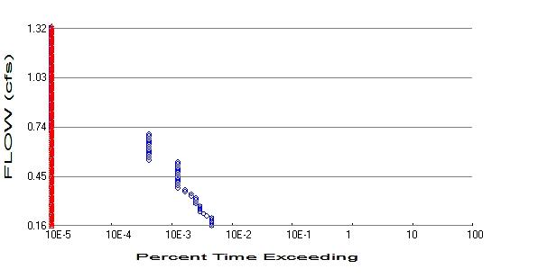
+
2023-01-24-Ridge View 2/27/2023 7:22:01 AM Page 12
POC 1
Predeveloped
Mitigated Predeveloped
Total Pervious Area:
Total Impervious Area: 0 Mitigated Landuse Totals for POC #1 Total Pervious Area: 1.0268 Total Impervious Area: 1.0151 Flow
Flow Frequency Return Periods for Predeveloped.
Return Period Flow(cfs) 2 year 0.3188 5 year 0.652585 10 year 0.878333 25 year 1.143511 50 year 1.320231 100 year 1.477809 Flow Frequency Return Periods for Mitigated. POC #1 Return Period Flow(cfs) 2 year 0.071353 5 year 0.081224 10 year 0.086789 25 year 0.093042 50 year 0.097262 100 year 0.10118
Peaks Annual Peaks for Predeveloped and Mitigated. POC #1 Year Predeveloped Mitigated 1956 0.373 0.087 1957 0.039 0.056 1958 0.541 0.064 1959 0.140 0.079 1960 0.540 0.069 1961 0.280 0.082 1962 0.704 0.066
x
Landuse Totals for POC #1
2.0419
Frequency Method: Log Pearson Type III 17B
POC #1
Annual
Ranked Annual Peaks for Predeveloped and Mitigated. POC #1
2023-01-24-Ridge View 2/27/2023 7:22:13 AM Page 13 Rank Predeveloped Mitigated 1 0.7040 0.0874 2 0.5412 0.0817 3 0.5404 0.0790 4 0.3728 0.0692 5 0.2801 0.0662 6 0.1399 0.0639 7 0.0389 0.0561
2023-01-24-Ridge View 2/27/2023 7:22:13 AM Page 14
The Facility PASSED Flow(cfs) Predev Mit Percentage Pass/Fail 0.1594 11 0 0 Pass 0.1711 11 0 0 Pass 0.1829 11 0 0 Pass 0.1946 11 0 0 Pass 0.2063 11 0 0 Pass 0.2180 9 0 0 Pass 0.2298 8 0 0 Pass 0.2415 7 0 0 Pass 0.2532 7 0 0 Pass 0.2649 7 0 0 Pass 0.2767 7 0 0 Pass 0.2884 6 0 0 Pass 0.3001 6 0 0 Pass 0.3118 6 0 0 Pass 0.3236 6 0 0 Pass 0.3353 5 0 0 Pass 0.3470 5 0 0 Pass 0.3587 4 0 0 Pass 0.3705 4 0 0 Pass 0.3822 3 0 0 Pass 0.3939 3 0 0 Pass 0.4056 3 0 0 Pass 0.4174 3 0 0 Pass 0.4291 3 0 0 Pass 0.4408 3 0 0 Pass 0.4525 3 0 0 Pass 0.4643 3 0 0 Pass 0.4760 3 0 0 Pass 0.4877 3 0 0 Pass 0.4994 3 0 0 Pass 0.5112 3 0 0 Pass 0.5229 3 0 0 Pass 0.5346 3 0 0 Pass 0.5463 1 0 0 Pass 0.5581 1 0 0 Pass 0.5698 1 0 0 Pass 0.5815 1 0 0 Pass 0.5932 1 0 0 Pass 0.6050 1 0 0 Pass 0.6167 1 0 0 Pass 0.6284 1 0 0 Pass 0.6401 1 0 0 Pass 0.6519 1 0 0 Pass 0.6636 1 0 0 Pass 0.6753 1 0 0 Pass 0.6871 1 0 0 Pass 0.6988 1 0 0 Pass 0.7105 0 0 0 Pass 0.7222 0 0 0 Pass 0.7340 0 0 0 Pass 0.7457 0 0 0 Pass 0.7574 0 0 0 Pass 0.7691 0 0 0 Pass
Duration Flows
2023-01-24-Ridge View 2/27/2023 7:22:14 AM Page 15 0.7809 0 0 0 Pass 0.7926 0 0 0 Pass 0.8043 0 0 0 Pass 0.8160 0 0 0 Pass 0.8278 0 0 0 Pass 0.8395 0 0 0 Pass 0.8512 0 0 0 Pass 0.8629 0 0 0 Pass 0.8747 0 0 0 Pass 0.8864 0 0 0 Pass 0.8981 0 0 0 Pass 0.9098 0 0 0 Pass 0.9216 0 0 0 Pass 0.9333 0 0 0 Pass 0.9450 0 0 0 Pass 0.9567 0 0 0 Pass 0.9685 0 0 0 Pass 0.9802 0 0 0 Pass 0.9919 0 0 0 Pass 1.0036 0 0 0 Pass 1.0154 0 0 0 Pass 1.0271 0 0 0 Pass 1.0388 0 0 0 Pass 1.0505 0 0 0 Pass 1.0623 0 0 0 Pass 1.0740 0 0 0 Pass 1.0857 0 0 0 Pass 1.0974 0 0 0 Pass 1.1092 0 0 0 Pass 1.1209 0 0 0 Pass 1.1326 0 0 0 Pass 1.1443 0 0 0 Pass 1.1561 0 0 0 Pass 1.1678 0 0 0 Pass 1.1795 0 0 0 Pass 1.1912 0 0 0 Pass 1.2030 0 0 0 Pass 1.2147 0 0 0 Pass 1.2264 0 0 0 Pass 1.2382 0 0 0 Pass 1.2499 0 0 0 Pass 1.2616 0 0 0 Pass 1.2733 0 0 0 Pass 1.2851 0 0 0 Pass 1.2968 0 0 0 Pass 1.3085 0 0 0 Pass 1.3202 0 0 0 Pass
Water Quality
Water Quality BMP Flow and Volume for POC #1
On-line facility volume: 0 acre-feet
On-line facility target flow: 0 cfs.
Adjusted for 15 min: 0 cfs.
Off-line facility target flow: 0 cfs.
Adjusted for 15 min: 0 cfs.
2023-01-24-Ridge View 2/27/2023 7:22:14 AM Page 16
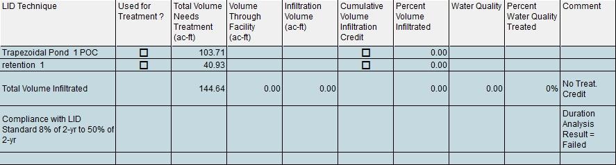
2023-01-24-Ridge View 2/27/2023 7:22:14 AM Page 17 LID Report
Model Default Modifications
Total of 0 changes have been made.
PERLND Changes
No PERLND changes have been made.
IMPLND Changes
No IMPLND changes have been made.
2023-01-24-Ridge View 2/27/2023 7:22:22 AM Page 18
Predeveloped Schematic
2023-01-24-Ridge View 2/27/2023 7:22:22 AM Page 19
Appendix
Mitigated Schematic
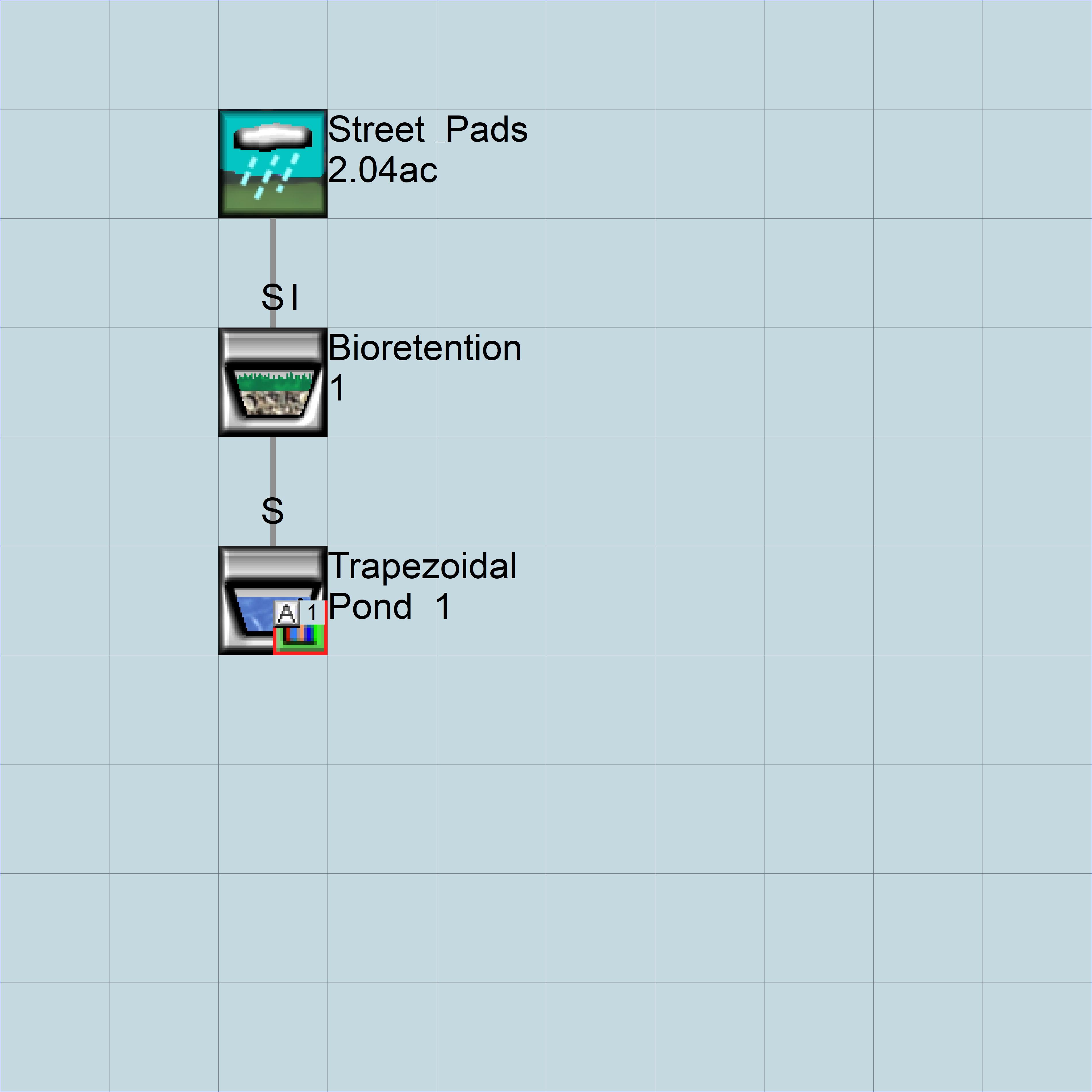
2023-01-24-Ridge View 2/27/2023 7:22:30 AM Page 20
Predeveloped UCI File
2023-01-24-Ridge View 2/27/2023 7:22:38 AM Page 21
RUN GLOBAL WWHM4 model simulation START 1955 10 01 END 2009 09 30 RUN INTERP OUTPUT LEVEL 3 0 RESUME 0 RUN 1 UNIT SYSTEM 1 END GLOBAL FILES <File> <Un#> <-----------File Name------------------------------>*** <-ID-> *** WDM 26 2023-01-24-Ridge View.wdm MESSU 25 Pre2023-01-24-Ridge View.MES 27 Pre2023-01-24-Ridge View.L61 28 Pre2023-01-24-Ridge View.L62 30 POC2023-01-24-Ridge View1.dat END FILES OPN SEQUENCE INGRP INDELT 00:15 PERLND 3 COPY 501 DISPLY 1 END INGRP END OPN SEQUENCE DISPLY DISPLY-INFO1 # - #<----------Title----------->***TRAN PIVL DIG1 FIL1 PYR DIG2 FIL2 YRND 1 Residential MAX 1 2 30 9 END DISPLY-INFO1 END DISPLY COPY TIMESERIES # - # NPT NMN *** 1 1 1 501 1 1 END TIMESERIES END COPY GENER OPCODE # # OPCD *** END OPCODE PARM # # K *** END PARM END GENER PERLND GEN-INFO <PLS ><-------Name------->NBLKS Unit-systems Printer *** # - # User t-series Engl Metr *** in out *** 3 A/B, Forest, Steep 1 1 1 1 27 0 END GEN-INFO *** Section PWATER*** ACTIVITY <PLS > ************* Active Sections ***************************** # - # ATMP SNOW PWAT SED PST PWG PQAL MSTL PEST NITR PHOS TRAC *** 3 0 0 1 0 0 0 0 0 0 0 0 0 END ACTIVITY PRINT-INFO <PLS > ***************** Print-flags ***************************** PIVL PYR # - # ATMP SNOW PWAT SED PST PWG PQAL MSTL PEST NITR PHOS TRAC ********* 3 0 0 4 0 0 0 0 0 0 0 0 0 1 9 END PRINT-INFO
> PWATER variable monthly parameter value flags ***
> *** Initial conditions at start of simulation ran from 1990 to end of 1992 (pat 1-11-95) RUN 21 ***
END PERLND
IMPLND
GEN-INFO
<PLS ><-------Name-------> Unit-systems Printer *** # - # User t-series Engl Metr *** in out ***
END GEN-INFO *** Section IWATER***
ACTIVITY
<PLS > ************* Active Sections *****************************
# - # ATMP SNOW IWAT SLD IWG IQAL ***
END ACTIVITY
PRINT-INFO
<ILS > ******** Print-flags ******** PIVL PYR
# - # ATMP SNOW IWAT SLD IWG IQAL *********
END PRINT-INFO
IWAT-PARM1
<PLS > IWATER variable monthly parameter value flags ***
# - # CSNO RTOP VRS VNN RTLI ***
END IWAT-PARM1
IWAT-PARM2
<PLS > IWATER input info: Part 2 ***
# - # *** LSUR SLSUR NSUR RETSC
END IWAT-PARM2
IWAT-PARM3
<PLS > IWATER input info: Part 3 ***
# - # ***PETMAX PETMIN
END IWAT-PARM3
IWAT-STATE1
<PLS > *** Initial conditions at start of simulation
# - # *** RETS SURS
END IWAT-STATE1
2023-01-24-Ridge View 2/27/2023 7:22:38 AM Page 22 PWAT-PARM1 <PLS
# - # CSNO
VUZ VNN
VIRC VLE INFC HWT
3 0 0 0 0 0 0 0 0 0 0 0 END PWAT-PARM1 PWAT-PARM2 <PLS > PWATER
# - # ***FOREST LZSN INFILT LSUR SLSUR KVARY AGWRC 3 0 5 2 400 0.15 0.3 0.996 END PWAT-PARM2 PWAT-PARM3 <PLS > PWATER input info: Part
*** # - # ***PETMAX PETMIN INFEXP INFILD DEEPFR BASETP AGWETP 3 0 0 2 2 0 0 0 END PWAT-PARM3 PWAT-PARM4 <PLS > PWATER input info: Part
# - # CEPSC UZSN NSUR INTFW IRC LZETP *** 3 0.2 0.5 0.35 0 0.7 0.7 END PWAT-PARM4 PWAT-STATE1
# - # *** CEPS SURS UZS IFWS LZS AGWS GWVS 3 0 0 0 0 3 1 0 END
RTOP UZFG VCS
VIFW
***
input info: Part 2 ***
3
4 ***
<PLS
PWAT-STATE1
END IMPLND
SCHEMATIC
<-Source-> <--Area--> <-Target-> MBLK *** <Name> # <-factor-> <Name> # Tbl# *** Residential*** PERLND 3
COPY 501 12
501 13
******Routing******
END SCHEMATIC NETWORK
<-Volume-> <-Grp> <-Member-><--Mult-->Tran <-Target vols> <-Grp> <-Member-> *** <Name> # <Name> # #<-factor->strg <Name> # # <Name> # # *** COPY 501 OUTPUT MEAN 1 1 48.4 DISPLY 1 INPUT TIMSER 1
<-Volume-> <-Grp> <-Member-><--Mult-->Tran <-Target vols> <-Grp> <-Member-> *** <Name> # <Name> # #<-factor->strg <Name> # # <Name> # # ***
END NETWORK
RCHRES
GEN-INFO
RCHRES Name Nexits Unit Systems Printer *** # - #<------------------><---> User T-series Engl Metr LKFG *** in out ***
END GEN-INFO *** Section RCHRES***
ACTIVITY
<PLS > ************* Active Sections ***************************** # - # HYFG ADFG CNFG HTFG SDFG GQFG OXFG NUFG PKFG PHFG ***
END ACTIVITY
PRINT-INFO
<PLS > ***************** Print-flags ******************* PIVL PYR # - # HYDR ADCA CONS HEAT SED GQL OXRX NUTR PLNK PHCB PIVL PYR *********
END PRINT-INFO
HYDR-PARM1
RCHRES Flags for each HYDR Section *** # - # VC A1 A2 A3 ODFVFG for each *** ODGTFG for each FUNCT for each FG FG FG FG possible exit *** possible exit possible exit *
***
END HYDR-PARM1
HYDR-PARM2 # - # FTABNO LEN DELTH STCOR KS DB50 ***
<------><--------><--------><--------><--------><--------><--------> ***
END HYDR-PARM2
HYDR-INIT RCHRES Initial conditions for each HYDR section ***
# - # *** VOL Initial value of COLIND Initial value of OUTDGT *** ac-ft for each possible exit for each possible exit
<------><--------> <---><---><---><---><---> *** <---><---><---><---><--->
END HYDR-INIT
END RCHRES
SPEC-ACTIONS
END SPEC-ACTIONS
FTABLES
END FTABLES
EXT SOURCES
<-Volume-> <Member> SsysSgap<--Mult-->Tran <-Target vols> <-Grp> <-Member-> *** <Name> # <Name> # tem strg<-factor->strg <Name> # # <Name> # # ***
2023-01-24-Ridge View 2/27/2023 7:22:38 AM Page 23
PERLND
2.0419 COPY
2.0419
3
* * * * * * * * * * * * *
WDM 2 PREC ENGL 1.429 PERLND 1 999 EXTNL PREC WDM 2 PREC ENGL 1.429 IMPLND 1 999 EXTNL PREC
2023-01-24-Ridge View 2/27/2023 7:22:38 AM Page 24
1 EVAP ENGL 0.76 PERLND 1 999 EXTNL PETINP WDM 1 EVAP ENGL 0.76 IMPLND 1 999 EXTNL PETINP
EXT SOURCES EXT TARGETS <-Volume-> <-Grp>
<-Volume-> <Member> Tsys Tgap Amd *** <Name> # <Name> # #<-factor->strg <Name> # <Name> tem strg strg*** COPY 501 OUTPUT MEAN 1 1 48.4 WDM 501 FLOW ENGL REPL END EXT TARGETS MASS-LINK <Volume> <-Grp> <-Member-><--Mult--> <Target> <-Grp> <-Member->*** <Name> <Name> # #<-factor-> <Name> <Name> # #*** MASS-LINK 12 PERLND PWATER SURO 0.083333 COPY INPUT MEAN END MASS-LINK 12 MASS-LINK 13 PERLND PWATER IFWO 0.083333 COPY INPUT MEAN END MASS-LINK 13 END MASS-LINK END RUN
WDM
END
<-Member-><--Mult-->Tran
Mitigated UCI File
2023-01-24-Ridge View 2/27/2023 7:22:38 AM Page 25
RUN GLOBAL WWHM4 model simulation START 1955 10 01 END 2009 09 30 RUN INTERP OUTPUT LEVEL 3 0 RESUME 0 RUN 1 UNIT SYSTEM 1 END GLOBAL FILES <File> <Un#> <-----------File Name------------------------------>*** <-ID-> *** WDM 26 2023-01-24-Ridge View.wdm MESSU 25 Mit2023-01-24-Ridge View.MES 27 Mit2023-01-24-Ridge View.L61 28 Mit2023-01-24-Ridge View.L62 30 POC2023-01-24-Ridge View1.dat END FILES OPN SEQUENCE INGRP INDELT 00:15 PERLND 7 IMPLND 3 IMPLND 4 IMPLND 6 GENER 2 RCHRES 1 RCHRES 2 RCHRES 3 COPY 1 COPY 501 DISPLY 1 END INGRP END OPN SEQUENCE DISPLY DISPLY-INFO1 # - #<----------Title----------->***TRAN PIVL DIG1 FIL1 PYR DIG2 FIL2 YRND 1 Trapezoidal Pond 1 MAX 1 2 30 9 END DISPLY-INFO1 END DISPLY COPY TIMESERIES # - # NPT NMN *** 1 1 1 501 1 1 END TIMESERIES END COPY GENER OPCODE # # OPCD *** 2 24 END OPCODE PARM # # K *** 2 0. END PARM END GENER PERLND GEN-INFO <PLS ><-------Name------->NBLKS Unit-systems Printer *** # - # User t-series Engl Metr *** in out *** 7 A/B, Lawn, Flat 1 1 1 1 27 0 END GEN-INFO *** Section PWATER*** ACTIVITY <PLS > ************* Active Sections *****************************
> ***************** Print-flags *****************************
> PWATER variable monthly parameter value flags ***
input info: Part 3 ***
PWATER input info: Part 4 ***
> *** Initial conditions at start of simulation ran from 1990 to end of 1992 (pat 1-11-95)
2023-01-24-Ridge View 2/27/2023 7:22:38 AM Page 26 # - # ATMP SNOW PWAT SED PST PWG PQAL MSTL PEST NITR PHOS TRAC *** 7 0 0 1 0 0 0 0 0 0 0 0 0 END ACTIVITY PRINT-INFO <PLS
PIVL PYR # - # ATMP SNOW PWAT SED PST PWG PQAL MSTL PEST NITR PHOS TRAC ********* 7 0 0 4 0 0 0 0 0 0 0 0 0 1 9 END PRINT-INFO PWAT-PARM1 <PLS
# - # CSNO RTOP UZFG VCS VUZ VNN VIFW VIRC VLE INFC HWT *** 7 0 0 0 0 0 0 0 0 0 0 0 END PWAT-PARM1 PWAT-PARM2 <PLS > PWATER
# - # ***FOREST LZSN INFILT LSUR SLSUR KVARY AGWRC 7 0 5 0.8 400 0.05 0.3 0.996 END PWAT-PARM2 PWAT-PARM3 <PLS > PWATER
# - # ***PETMAX PETMIN INFEXP INFILD DEEPFR BASETP AGWETP 7 0 0 2 2 0 0 0 END PWAT-PARM3 PWAT-PARM4 <PLS
# - # CEPSC UZSN NSUR INTFW IRC LZETP *** 7 0.1 0.5 0.25 0 0.7 0.25 END PWAT-PARM4 PWAT-STATE1 <PLS
RUN 21
# - # *** CEPS SURS UZS IFWS LZS AGWS GWVS 7 0 0 0 0 3 1 0 END PWAT-STATE1 END PERLND IMPLND GEN-INFO <PLS
Unit-systems
# - # User t-series Engl Metr *** in out *** 3 ROADS/STEEP 1 1 1 27 0 4 ROOF TOPS/FLAT 1 1 1 27 0 6 DRIVEWAYS/MOD 1 1 1 27 0 END GEN-INFO *** Section IWATER*** ACTIVITY <PLS > ************* Active Sections ***************************** # - # ATMP SNOW IWAT SLD IWG IQAL *** 3 0 0 1 0 0 0 4 0 0 1 0 0 0 6 0 0 1 0 0 0 END ACTIVITY PRINT-INFO <ILS > ******** Print-flags ******** PIVL PYR # - # ATMP SNOW IWAT SLD IWG IQAL ********* 3 0 0 4 0 0 0 1 9 4 0 0 4 0 0 0 1 9 6 0 0 4 0 0 0 1 9 END PRINT-INFO IWAT-PARM1
input info: Part 2 ***
>
***
><-------Name------->
Printer ***
<PLS > IWATER variable monthly parameter value flags ***
<-Volume-> <-Grp> <-Member-><--Mult-->Tran <-Target vols> <-Grp> <-Member-> ***
2023-01-24-Ridge
2/27/2023 7:22:38 AM Page 27
View
# - # CSNO RTOP VRS VNN RTLI *** 3 0 0 0 0 0 4 0 0 0 0 0 6 0 0 0 0 0 END IWAT-PARM1 IWAT-PARM2 <PLS > IWATER input info: Part 2
# - # *** LSUR SLSUR NSUR RETSC 3 400 0.1 0.1 0.05 4 400 0.01 0.1 0.1 6 400 0.05 0.1 0.08 END IWAT-PARM2 IWAT-PARM3 <PLS > IWATER input
Part 3
# - # ***PETMAX PETMIN 3 0 0 4 0 0 6 0 0 END IWAT-PARM3 IWAT-STATE1 <PLS
# - #
RETS SURS 3 0 0 4 0 0 6 0 0 END IWAT-STATE1 END IMPLND SCHEMATIC <-Source-> <--Area--> <-Target-> MBLK *** <Name> # <-factor-> <Name> # Tbl# *** Street & Pads*** PERLND 7 1.0268 RCHRES 1 2 PERLND 7 1.0268 RCHRES 1 3 IMPLND 3 0.4711 RCHRES 1 5 IMPLND 4 0.4017 RCHRES 1 5 IMPLND 6 0.1423 RCHRES 1 5 ******Routing****** RCHRES 2 1 RCHRES 3 6 RCHRES 2 COPY 1 16 RCHRES 1 1 RCHRES 3 7 RCHRES 1 COPY 1 17 RCHRES 1 1 RCHRES 2 8 RCHRES 3 1 COPY 501 16 END SCHEMATIC NETWORK <-Volume-> <-Grp> <-Member-><--Mult-->Tran <-Target vols> <-Grp> <-Member-> *** <Name> # <Name> # #<-factor->strg <Name> # # <Name> # # *** COPY 501 OUTPUT MEAN 1 1 48.4 DISPLY 1 INPUT TIMSER 1 GENER 2 OUTPUT TIMSER .0011111 RCHRES 1 EXTNL OUTDGT 1
***
info:
***
> *** Initial conditions at start of simulation
***
<Name>
<Name> # #<-factor->strg <Name> # # <Name> # #
END NETWORK RCHRES GEN-INFO RCHRES Name Nexits Unit Systems Printer *** # - #<------------------><---> User T-series Engl Metr LKFG *** in out *** 1 Surface retentio-009 2 1 1 1 28 0 1
#
***
2023-01-24-Ridge View 2/27/2023 7:22:38 AM Page 28 2 Bioretention 1 1 1 1 1 28 0 1 3 Trapezoidal Pond-010 1 1 1 1 28 0 1 END GEN-INFO *** Section RCHRES*** ACTIVITY <PLS > ************* Active Sections ***************************** # - # HYFG ADFG CNFG HTFG SDFG GQFG OXFG NUFG PKFG PHFG *** 1 1 0 0 0 0 0 0 0 0 0 2 1 0 0 0 0 0 0 0 0 0 3 1 0 0 0 0 0 0 0 0 0 END ACTIVITY PRINT-INFO <PLS > ***************** Print-flags ******************* PIVL PYR # - # HYDR ADCA CONS HEAT SED GQL OXRX NUTR PLNK PHCB PIVL PYR ********* 1 4 0 0 0 0 0 0 0 0 0 1 9 2 4 0 0 0 0 0 0 0 0 0 1 9 3 4 0 0 0 0 0 0 0 0 0 1 9 END PRINT-INFO HYDR-PARM1 RCHRES Flags for each HYDR Section *** # - # VC A1 A2 A3 ODFVFG for each *** ODGTFG for each FUNCT for each FG FG FG FG possible exit *** possible exit possible exit * * * * * * * * * * * * * * *** 1 0 1 0 0 4 5 0 0 0 0 1 0 0 0 2 1 2 2 2 2 0 1 0 0 4 0 0 0 0 0 0 0 0 0 2 2 2 2 2 3 0 1 0 0 4 0 0 0 0 0 0 0 0 0 2 2 2 2 2 END HYDR-PARM1 HYDR-PARM2 # - # FTABNO LEN DELTH STCOR KS DB50 *** <------><--------><--------><--------><--------><--------><--------> *** 1 1 0.01 0.0 527.26 0.0 0.0 2 2 0.01 0.0 527.26 0.0 0.0 3 3 0.06 0.0 518.5 0.5 0.0 END HYDR-PARM2 HYDR-INIT RCHRES Initial conditions for each HYDR section *** # - # *** VOL Initial value of COLIND Initial value of OUTDGT *** ac-ft for each possible exit for each possible exit <------><--------> <---><---><---><---><---> *** <---><---><---><---><---> 1 0 4.0 5.0 0.0 0.0 0.0 0.0 0.0 0.0 0.0 0.0 2 0 4.0 0.0 0.0 0.0 0.0 0.0 0.0 0.0 0.0 0.0 3 0 4.0 0.0 0.0 0.0 0.0 0.0 0.0 0.0 0.0 0.0 END HYDR-INIT END RCHRES SPEC-ACTIONS *** User-Defined Variable Quantity Lines *** addr *** <------> *** kwd varnam optyp opn vari s1 s2 s3 tp multiply lc ls ac as agfn *** <****> <----> <----> <-> <----><-><-><-><-><--------> <><-> <><-> <--> *** UVQUAN vol2 RCHRES 2 VOL 4 UVQUAN v2m2 GLOBAL WORKSP 1 3 UVQUAN vpo2 GLOBAL WORKSP 2 3 UVQUAN v2d2 GENER 2 K 1 3 *** User-Defined Target Variable Names *** addr or addr or *** <------> <------> *** kwd varnam ct vari s1 s2 s3 frac oper vari s1 s2 s3 frac oper <****> <----><-> <----><-><-><-> <---> <--> <----><-><-><-> <---> <--> UVNAME v2m2 1 WORKSP 1 1.0 QUAN UVNAME vpo2 1 WORKSP 2 1.0 QUAN UVNAME v2d2 1 K 1 1.0 QUAN *** opt foplop dcdts yr mo dy hr mn d t vnam s1 s2 s3 ac quantity tc ts rp <****><-><--><><-><--> <> <> <> <><><> <----><-><-><-><-><--------> <> <-><-> GENER 2 v2m2 = 651.42
*** Compute remaining available pore space
2
2
*** Check to see if VPORA goes negative; if so set VPORA = 0.0 IF (vpo2 < 0.0) THEN
2
END IF
*** Infiltration volume
2/27/2023 7:22:38 AM Page 29
2023-01-24-Ridge View
GENER
vpo2 = v2m2 GENER
vpo2 -= vol2
GENER
vpo2 = 0.0
GENER 2 v2d2 = vpo2
FTABLES FTABLE 2 51 4 Depth Area Volume Outflow1 Velocity Travel Time*** (ft) (acres) (acre-ft) (cfs) (ft/sec) (Minutes)*** 0.000000 0.042700 0.000000 0.000000 0.060440 0.042102 0.000052 0.000000 0.120879 0.041168 0.000113 0.000000 0.181319 0.040241 0.000183 0.000000 0.241758 0.039319 0.000262 0.000000 0.302198 0.038403 0.000350 0.000000 0.362637 0.037493 0.000448 0.000000 0.423077 0.036590 0.000555 0.000000 0.483516 0.035692 0.000671 0.000590 0.543956 0.034800 0.000797 0.000716 0.604396 0.033915 0.000933 0.001014 0.664835 0.033035 0.001078 0.001378 0.725275 0.032162 0.001233 0.001813 0.785714 0.031294 0.001398 0.002324 0.846154 0.030433 0.001573 0.002915 0.906593 0.029578 0.001757 0.003589 0.967033 0.028728 0.001952 0.004349 1.027473 0.027885 0.002158 0.005201 1.087912 0.027048 0.002373 0.005366 1.148352 0.026217 0.002599 0.006146 1.208791 0.025391 0.002835 0.007188 1.269231 0.024572 0.003082 0.008330 1.329670 0.023759 0.003339 0.009574 1.390110 0.022952 0.003607 0.010453 1.450549 0.022151 0.003886 0.010925 1.510989 0.021356 0.004149 0.012382 1.571429 0.020567 0.004422 0.013950 1.631868 0.019784 0.004704 0.015628 1.692308 0.019007 0.004997 0.017417 1.752747 0.018236 0.005300 0.017688 1.813187 0.017472 0.005614 0.019309 1.873626 0.016713 0.005937 0.048611 1.934066 0.015960 0.006271 0.048611 1.994505 0.015213 0.006616 0.048611 2.054945 0.014473 0.006971 0.048611 2.115385 0.013738 0.007336 0.048611 2.175824 0.013010 0.007713 0.048611 2.236264 0.012287 0.008100 0.048611 2.296703 0.011571 0.008498 0.048611 2.357143 0.010860 0.008906 0.048611 2.417582 0.010156 0.009326 0.048611 2.478022 0.009457 0.009757 0.048611 2.538462 0.008765 0.010199 0.048611 2.598901 0.008079 0.010652 0.048611 2.659341 0.007398 0.011117 0.048611 2.719780 0.006724 0.011593 0.048611 2.780220 0.006056 0.012080 0.048611 2.840659 0.005394 0.012579 0.048611 2.901099 0.004738 0.013090 0.048611 2.961538 0.004088 0.013612 0.048611 3.000000 0.003444 0.014955 0.048611 END FTABLE 2 FTABLE 1 43 5 Depth Area Volume Outflow1 Outflow2 Velocity Travel Time***
END SPEC-ACTIONS
2023-01-24-Ridge View 2/27/2023 7:22:38 AM Page 30 (ft) (acres) (acre-ft) (cfs) (cfs) (ft/sec) (Minutes)*** 0.000000 0.003444 0.000000 0.000000 0.000000 0.060440 0.043643 0.002609 0.000000 0.020833 0.120879 0.044593 0.005276 0.000000 0.022512 0.181319 0.045549 0.008000 0.000000 0.023352 0.241758 0.046511 0.010782 0.000000 0.024191 0.302198 0.047479 0.013622 0.000000 0.025031 0.362637 0.048453 0.016521 0.000000 0.025870 0.423077 0.049433 0.019479 0.000000 0.026709 0.483516 0.050419 0.022497 0.000000 0.027549 0.543956 0.051411 0.025574 0.000000 0.028388 0.604396 0.052409 0.028712 0.000000 0.029228 0.664835 0.053413 0.031909 0.000000 0.030067 0.725275 0.054423 0.035168 0.000000 0.030907 0.785714 0.055439 0.038488 0.000000 0.031746 0.846154 0.056462 0.041870 0.000000 0.032585 0.906593 0.057490 0.045313 0.000000 0.033425 0.967033 0.058524 0.048819 0.000000 0.034264 1.027473 0.059565 0.052388 0.000000 0.035104 1.087912 0.060611 0.056020 0.000000 0.035943 1.148352 0.061663 0.059715 0.000000 0.036783 1.208791 0.062722 0.063474 0.000000 0.037622 1.269231 0.063786 0.067297 0.000000 0.038462 1.329670 0.064857 0.071184 0.000000 0.039301 1.390110 0.065933 0.075137 0.000000 0.040140 1.450549 0.067016 0.079154 0.000000 0.040980 1.510989 0.068105 0.083238 0.000000 0.041819 1.571429 0.069199 0.087387 0.000000 0.042659 1.631868 0.070300 0.091603 0.000000 0.043498 1.692308 0.071407 0.095885 0.000000 0.044338 1.752747 0.072520 0.100234 0.000000 0.045177 1.813187 0.073639 0.104651 0.000000 0.046017 1.873626 0.074763 0.109136 0.000000 0.046856 1.934066 0.075894 0.113689 0.000000 0.047695 1.994505 0.077031 0.118310 0.000000 0.048535 2.054945 0.078174 0.123001 0.067798 0.049374 2.115385 0.079323 0.127760 0.194303 0.050214 2.175824 0.080478 0.132589 0.312810 0.051053 2.236264 0.081640 0.137488 0.380140 0.051893 2.296703 0.082807 0.142458 0.428905 0.052732 2.357143 0.083980 0.147498 0.470566 0.053571 2.417582 0.085159 0.152610 0.508828 0.054411 2.478022 0.086344 0.157792 0.544407 0.055250 2.500000 0.086777 0.159695 0.577799 0.055556 END FTABLE 1 FTABLE 3 91 4 Depth Area Volume Outflow1 Velocity Travel Time*** (ft) (acres) (acre-ft) (cfs) (ft/sec) (Minutes)*** 0.000000 2.066116 0.000000 0.000000 0.061111 2.071169 0.126417 0.000000 0.122222 2.076229 0.253143 0.000000 0.183333 2.081295 0.380179 0.000000 0.244444 2.086367 0.507524 0.000000 0.305556 2.091445 0.635179 0.000000 0.366667 2.096530 0.763145 0.000000 0.427778 2.101620 0.891422 0.000000 0.488889 2.106717 1.020010 0.000000 0.550000 2.111820 1.148910 0.015534 0.611111 2.116929 1.278122 0.023157 0.672222 2.122045 1.407646 0.028830 0.733333 2.127166 1.537483 0.033557 0.794444 2.132294 1.667633 0.037696 0.855556 2.137428 1.798097 0.041424 0.916667 2.142568 1.928874 0.044843 0.977778 2.147714 2.059966 0.048019 1.038889 2.152866 2.191373 0.050997 1.100000 2.158025 2.323095 0.053811 1.161111 2.163189 2.455132 0.056485 1.222222 2.168360 2.587485 0.059038
2023-01-24-Ridge View 2/27/2023 7:22:38 AM Page 31 1.283333 2.173537 2.720154 0.061485 1.344444 2.178721 2.853139 0.063839 1.405556 2.183910 2.986442 0.066108 1.466667 2.189106 3.120062 0.068303 1.527778 2.194307 3.253999 0.070428 1.588889 2.199515 3.388255 0.072492 1.650000 2.204729 3.522829 0.074499 1.711111 2.209950 3.657722 0.076452 1.772222 2.215176 3.792934 0.078357 1.833333 2.220409 3.928466 0.080217 1.894444 2.225647 4.064318 0.082035 1.955556 2.230892 4.200490 0.083813 2.016667 2.236143 4.336983 0.085555 2.077778 2.241401 4.473797 0.087261 2.138889 2.246664 4.610932 0.088935 2.200000 2.251934 4.748389 0.090578 2.261111 2.257210 4.886168 0.092192 2.322222 2.262492 5.024270 0.093778 2.383333 2.267780 5.162695 0.095337 2.444444 2.273074 5.301444 0.096872 2.505556 2.278375 5.440516 0.098382 2.566667 2.283681 5.579912 0.099870 2.627778 2.288994 5.719633 0.101336 2.688889 2.294313 5.859678 0.102780 2.750000 2.299638 6.000049 0.104205 2.811111 2.304970 6.140745 0.105611 2.872222 2.310307 6.281767 0.106998 2.933333 2.315651 6.423116 0.108368 2.994444 2.321001 6.564792 0.109720 3.055556 2.326357 6.706794 0.111056 3.116667 2.331719 6.849124 0.112376 3.177778 2.337088 6.991782 0.113680 3.238889 2.342462 7.134769 0.114970 3.300000 2.347843 7.278084 0.116246 3.361111 2.353230 7.421727 0.117508 3.422222 2.358623 7.565701 0.118756 3.483333 2.364022 7.710004 0.119991 3.544444 2.369428 7.854637 0.487354 3.605556 2.374839 7.999601 0.686684 3.666667 2.380257 8.144895 0.832651 3.727778 2.385681 8.290521 0.953695 3.788889 2.391111 8.436479 1.059464 3.850000 2.396548 8.582768 1.154630 3.911111 2.401990 8.729390 1.241878 3.972222 2.407439 8.876345 1.322921 4.033333 2.412893 9.023633 1.398931 4.094444 2.418354 9.171254 1.470751 4.155556 2.423822 9.319210 1.539012 4.216667 2.429295 9.467499 1.604200 4.277778 2.434775 9.616124 1.666700 4.338889 2.440260 9.765083 1.726823 4.400000 2.445752 9.914378 1.784824 4.461111 2.451250 10.06401 1.840914 4.522222 2.456754 10.21398 1.930419 4.583333 2.462265 10.36428 2.202345 4.644444 2.467781 10.51492 2.572029 4.705556 2.473304 10.66590 2.991606 4.766667 2.478833 10.81721 3.416231 4.827778 2.484368 10.96887 3.801741 4.888889 2.489909 11.12086 4.113429 4.950000 2.495457 11.27319 4.339366 5.011111 2.501010 11.42586 4.534231 5.072222 2.506570 11.57887 4.708784 5.133333 2.512136 11.73222 4.875689 5.194444 2.517708 11.88591 5.035960 5.255556 2.523286 12.03994 5.190394 5.316667 2.528871 12.19431 5.339639 5.377778 2.534461 12.34902 5.484223 5.438889 2.540058 12.50408 5.624590 5.500000 2.545661 12.65947 5.761113
END FTABLE 3
END FTABLES
EXT SOURCES
<-Volume-> <Member> SsysSgap<--Mult-->Tran <-Target vols> <-Grp> <-Member-> *** <Name> # <Name> # tem strg<-factor->strg <Name> # # <Name> # # ***
END EXT SOURCES EXT TARGETS <-Volume-> <-Grp> <-Member-><--Mult-->Tran <-Volume-> <Member> Tsys Tgap Amd *** <Name>
View 2/27/2023 7:22:38 AM Page 32
2023-01-24-Ridge
WDM 2 PREC ENGL 1.429 PERLND 1 999 EXTNL PREC WDM 2 PREC ENGL 1.429 IMPLND 1 999 EXTNL PREC WDM 1 EVAP ENGL 0.76 PERLND 1 999 EXTNL PETINP WDM 1 EVAP ENGL 0.76 IMPLND 1 999 EXTNL PETINP WDM 2 PREC ENGL 1.429 RCHRES 1 EXTNL PREC WDM 2 PREC ENGL 1.429 RCHRES 3 EXTNL PREC WDM 1 EVAP ENGL 0.5 RCHRES 1 EXTNL POTEV WDM 1 EVAP ENGL 0.76 RCHRES 2 EXTNL POTEV WDM 1 EVAP ENGL 0.76 RCHRES 3 EXTNL POTEV
# <Name> tem strg strg*** RCHRES 3 HYDR RO 1 1 1 WDM 1000 FLOW ENGL REPL RCHRES 3 HYDR STAGE 1 1 1 WDM 1001 STAG ENGL REPL COPY 1 OUTPUT MEAN 1 1 48.4 WDM 701 FLOW ENGL REPL COPY 501 OUTPUT MEAN 1 1 48.4 WDM 801 FLOW ENGL REPL END EXT TARGETS MASS-LINK <Volume> <-Grp> <-Member-><--Mult--> <Target> <-Grp> <-Member->*** <Name> <Name> #
<Name> <Name> # #*** MASS-LINK 2 PERLND PWATER SURO 0.083333 RCHRES INFLOW IVOL END MASS-LINK 2 MASS-LINK 3 PERLND PWATER IFWO 0.083333 RCHRES INFLOW IVOL END MASS-LINK 3 MASS-LINK 5 IMPLND IWATER SURO 0.083333 RCHRES INFLOW IVOL END MASS-LINK 5 MASS-LINK 6 RCHRES ROFLOW RCHRES INFLOW END MASS-LINK 6 MASS-LINK 7 RCHRES OFLOW OVOL 1 RCHRES INFLOW IVOL END MASS-LINK 7 MASS-LINK 8 RCHRES OFLOW OVOL 2 RCHRES INFLOW IVOL END MASS-LINK 8 MASS-LINK 16 RCHRES ROFLOW COPY INPUT MEAN END MASS-LINK 16 MASS-LINK 17 RCHRES OFLOW OVOL 1 COPY INPUT MEAN END MASS-LINK 17 END MASS-LINK END RUN
# <Name> # #<-factor->strg <Name>
#<-factor->
2023-01-24-Ridge View 2/27/2023 7:22:38 AM Page 33
HSPF Message File
Predeveloped
Mitigated HSPF Message File
ERROR/WARNING ID: 341 6
DATE/TIME: 1955/12/21 13:30
RCHRES: 1
The volume of water in this reach/mixed reservoir is greater than the value in the "volume" column of the last row of RCHTAB(). To continue the simulation the table has been extrapolated, based on information contained in the last two rows. This will usually result in some loss of accuracy. If depth is being calculated it will also cause an error condition. Relevant data are:
ERROR/WARNING ID: 341 5
DATE/TIME: 1955/12/21 13:30
RCHRES: 1
Calculation of relative depth, using Newton's method of successive approximations, converged to an invalid value (not in range 0.0 to 1.0). Probably ftable was extrapolated. If extrapolation was small, no problem. Remedy; extend ftable. Relevant data are:
ERROR/WARNING ID: 341 6
DATE/TIME: 1955/12/21 13:45
RCHRES: 1
The volume of water in this reach/mixed reservoir is greater than the value in the "volume" column of the last row of RCHTAB(). To continue the simulation the table has been extrapolated, based on information contained in the last two rows. This will usually result in some loss of accuracy. If depth is being calculated it will also cause an error condition. Relevant data are:
ERROR/WARNING ID: 341 5
DATE/TIME: 1955/12/21 13:45
RCHRES: 1
Calculation of relative depth, using Newton's method of successive approximations, converged to an invalid value (not in range 0.0 to 1.0). Probably ftable was extrapolated. If extrapolation was small, no problem. Remedy; extend ftable. Relevant data are:
ERROR/WARNING ID: 341 6
DATE/TIME: 1955/12/21 14: 0
RCHRES: 1
2023-01-24-Ridge View 2/27/2023 7:22:38 AM Page 34
NROWS V1 V2 VOL 43 6.8734E+03 6956.3 7041.3
A B C RDEP1 RDEP2 COUNT 1.8861E+01 7522.3 -1.527E+04 2.0203 2.0203E+00 3
NROWS V1 V2 VOL 43 6.8734E+03 6956.3 7067.3
A B C RDEP1 RDEP2 COUNT 1.8861E+01 7522.3 -1.764E+04 2.3309 2.3309E+00 3
The volume of water in this reach/mixed reservoir is greater than the value in the "volume" column of the last row of RCHTAB(). To continue the simulation the table has been extrapolated, based on information contained in the last two rows. This will usually result in some loss of accuracy. If depth is being calculated it will also cause an error condition. Relevant data are:
ERROR/WARNING ID: 341 5
DATE/TIME: 1955/12/21 14: 0
RCHRES: 1
Calculation of relative depth, using Newton's method of successive approximations, converged to an invalid value (not in range 0.0 to 1.0). Probably ftable was extrapolated. If extrapolation was small, no problem. Remedy; extend ftable. Relevant data are:
ERROR/WARNING ID: 341 6
DATE/TIME: 1955/12/21 14:15
RCHRES: 1
The volume of water in this reach/mixed reservoir is greater than the value in the "volume" column of the last row of RCHTAB(). To continue the simulation the table has been extrapolated, based on information contained in the last two rows. This will usually result in some loss of accuracy. If depth is being calculated it will also cause an error condition. Relevant data are:
ERROR/WARNING ID: 341 5
DATE/TIME: 1955/12/21 14:15
RCHRES: 1
Calculation of relative depth, using Newton's method of successive approximations, converged to an invalid value (not in range 0.0 to 1.0). Probably ftable was extrapolated. If extrapolation was small, no problem. Remedy; extend ftable. Relevant data are:
ERROR/WARNING ID: 341 6
DATE/TIME: 1955/12/21 14:30
RCHRES: 1
The volume of water in this reach/mixed reservoir is greater than the value in the "volume" column of the last row of RCHTAB(). To continue the simulation the table has been extrapolated, based on information contained in the last two rows. This will usually result in some loss of accuracy. If depth is being calculated it will also cause an error condition.
Relevant data are:
2023-01-24-Ridge View 2/27/2023 7:22:38 AM Page 35
NROWS V1 V2 VOL 43 6.8734E+03 6956.3 7186.6
A B C RDEP1 RDEP2 COUNT 1.8861E+01 7522.3 -2.849E+04 3.7519 3.7519E+00 3
NROWS V1 V2 VOL 43 6.8734E+03 6956.3 7065.8
A B C RDEP1 RDEP2 COUNT 1.8861E+01 7522.3 -1.750E+04 2.3129 2.3129E+00 3
NROWS V1 V2 VOL 43 6.8734E+03 6956.3 7405.1
ERROR/WARNING ID: 341 5
DATE/TIME: 1955/12/21 14:30
RCHRES: 1
Calculation of relative depth, using Newton's method of successive approximations, converged to an invalid value (not in range 0.0 to 1.0). Probably ftable was extrapolated. If extrapolation was small, no problem. Remedy; extend ftable. Relevant data are:
ERROR/WARNING ID: 341 6
DATE/TIME: 1955/12/21 14:45
RCHRES: 1
The volume of water in this reach/mixed reservoir is greater than the value in the "volume" column of the last row of RCHTAB(). To continue the simulation the table has been extrapolated, based on information contained in the last two rows. This will usually result in some loss of accuracy. If depth is being calculated it will also cause an error condition. Relevant data are:
ERROR/WARNING ID: 341 5
DATE/TIME: 1955/12/21 14:45
RCHRES: 1
Calculation of relative depth, using Newton's method of successive approximations, converged to an invalid value (not in range 0.0 to 1.0). Probably ftable was extrapolated. If extrapolation was small, no problem. Remedy; extend ftable. Relevant data are:
ERROR/WARNING ID: 341 6
DATE/TIME: 1955/12/21 15: 0
RCHRES: 1
The volume of water in this reach/mixed reservoir is greater than the value in the "volume" column of the last row of RCHTAB(). To continue the simulation the table has been extrapolated, based on information contained in the last two rows. This will usually result in some loss of accuracy. If depth is being calculated it will also cause an error condition.
Relevant data are:
NROWS V1 V2 VOL 43 6.8734E+03 6956.3 7294.2
ERROR/WARNING ID: 341 5
DATE/TIME: 1955/12/21 15: 0
RCHRES: 1
Calculation of relative depth, using Newton's method of successive approximations, converged to an invalid value (not in range 0.0 to 1.0).
2023-01-24-Ridge View 2/27/2023 7:22:38 AM Page 36
A B C RDEP1 RDEP2 COUNT 1.8861E+01 7522.3 -4.837E+04 6.3298 6.3298E+00 3
NROWS V1 V2 VOL 43 6.8734E+03 6956.3 7489.5
A B C RDEP1 RDEP2 COUNT 1.8861E+01 7522.3 -5.604E+04 7.3160 7.3159E+00 3
Probably ftable was extrapolated. If extrapolation was small, no problem. Remedy; extend ftable. Relevant data are:
ERROR/WARNING ID: 341 6 DATE/TIME: 1955/12/21 15:15
RCHRES: 1
The volume of water in this reach/mixed reservoir is greater than the value in the "volume" column of the last row of RCHTAB(). To continue the simulation the table has been extrapolated, based on information contained in the last two rows. This will usually result in some loss of accuracy. If depth is being calculated it will also cause an error condition.
Relevant data are:
ERROR/WARNING ID: 341 5
DATE/TIME: 1955/12/21 15:15
RCHRES: 1
Calculation of relative depth, using Newton's method of successive approximations, converged to an invalid value (not in range 0.0 to 1.0). Probably ftable was extrapolated. If extrapolation was small, no problem. Remedy; extend ftable. Relevant data are:
ERROR/WARNING ID: 341 6
DATE/TIME: 1955/12/21 15:30
RCHRES: 1
The volume of water in this reach/mixed reservoir is greater than the value in the "volume" column of the last row of RCHTAB(). To continue the simulation the table has been extrapolated, based on information contained in the last two rows. This will usually result in some loss of accuracy. If depth is being calculated it will also cause an error condition. Relevant data are:
ERROR/WARNING ID: 341 5
DATE/TIME: 1955/12/21 15:30
RCHRES: 1
Calculation of relative depth, using Newton's method of successive approximations, converged to an invalid value (not in range 0.0 to 1.0). Probably ftable was extrapolated. If extrapolation was small, no problem. Remedy; extend ftable. Relevant data are:
ERROR/WARNING ID: 341 6
DATE/TIME: 1955/12/21 15:45
2023-01-24-Ridge View 2/27/2023 7:22:38 AM Page 37
A B C RDEP1 RDEP2 COUNT 1.8861E+01 7522.3 -3.828E+04 5.0252 5.0252E+00 3
NROWS V1 V2 VOL 43 6.8734E+03 6956.3 7152.6
A B C RDEP1 RDEP2 COUNT 1.8861E+01 7522.3 -2.540E+04 3.3480 3.3480E+00 3
V1 V2 VOL 43 6.8734E+03 6956.3 7045.1
NROWS
A B C RDEP1 RDEP2 COUNT 1.8861E+01 7522.3 -1.561E+04 2.0650 2.0650E+00 3
RCHRES: 1
The volume of water in this reach/mixed reservoir is greater than the value in the "volume" column of the last row of RCHTAB(). To continue the simulation the table has been extrapolated, based on information contained in the last two rows. This will usually result in some loss of accuracy. If depth is being calculated it will also cause an error condition. Relevant data are:
ERROR/WARNING ID: 341 5
DATE/TIME: 1955/12/21 15:45
RCHRES: 1
Calculation of relative depth, using Newton's method of successive approximations, converged to an invalid value (not in range 0.0 to 1.0). Probably ftable was extrapolated. If extrapolation was small, no problem. Remedy; extend ftable. Relevant data are:
ERROR/WARNING ID: 341 6
DATE/TIME: 1956/12/ 9 19: 0
RCHRES: 1
The volume of water in this reach/mixed reservoir is greater than the value in the "volume" column of the last row of RCHTAB(). To continue the simulation the table has been extrapolated, based on information contained in the last two rows. This will usually result in some loss of accuracy. If depth is being calculated it will also cause an error condition. Relevant data are:
ERROR/WARNING ID: 341 5
DATE/TIME: 1956/12/ 9 19: 0
RCHRES: 1
Calculation of relative depth, using Newton's method of successive approximations, converged to an invalid value (not in range 0.0 to 1.0). Probably ftable was extrapolated. If extrapolation was small, no problem. Remedy; extend ftable. Relevant data are:
ERROR/WARNING ID: 341 6
DATE/TIME: 1956/12/ 9 19:15
RCHRES: 1
The volume of water in this reach/mixed reservoir is greater than the value in the "volume" column of the last row of RCHTAB(). To continue the simulation the table has been extrapolated, based on information contained in the last two rows. This will usually result in some loss of accuracy. If depth is being calculated it will also cause an error condition. Relevant data are:
2023-01-24-Ridge View 2/27/2023 7:22:38 AM Page 38
NROWS V1 V2 VOL 43 6.8734E+03 6956.3 6961.2
A B C RDEP1 RDEP2 COUNT 1.8861E+01 7522.3 -7.985E+03 1.0595 1.0587E+00 2
NROWS V1 V2 VOL 43 6.8734E+03 6956.3 7149.0
A B C RDEP1 RDEP2 COUNT 1.8861E+01 7522.3 -2.507E+04 3.3058 3.3058 3
ERROR/WARNING ID: 341 5
DATE/TIME: 1956/12/ 9 19:15
RCHRES: 1
Calculation of relative depth, using Newton's method of successive approximations, converged to an invalid value (not in range 0.0 to 1.0). Probably ftable was extrapolated. If extrapolation was small, no problem. Remedy; extend ftable. Relevant data are:
ERROR/WARNING ID: 341 6
DATE/TIME: 1956/12/ 9 19:30
RCHRES: 1
The volume of water in this reach/mixed reservoir is greater than the value in the "volume" column of the last row of RCHTAB(). To continue the simulation the table has been extrapolated, based on information contained in the last two rows. This will usually result in some loss of accuracy. If depth is being calculated it will also cause an error condition. Relevant data are:
ERROR/WARNING ID: 341 5
DATE/TIME: 1956/12/ 9 19:30
RCHRES: 1
Calculation of relative depth, using Newton's method of successive approximations, converged to an invalid value (not in range 0.0 to 1.0). Probably ftable was extrapolated. If extrapolation was small, no problem. Remedy; extend ftable. Relevant data are:
ERROR/WARNING ID: 341 6
DATE/TIME: 1959/11/22 13:30
RCHRES: 1
The volume of water in this reach/mixed reservoir is greater than the value in the "volume" column of the last row of RCHTAB(). To continue the simulation the table has been extrapolated, based on information contained in the last two rows. This will usually result in some loss of accuracy. If depth is being calculated it will also cause an error condition. Relevant data are: NROWS V1 V2
ERROR/WARNING ID: 341 5
DATE/TIME: 1959/11/22 13:30
RCHRES: 1
2023-01-24-Ridge View 2/27/2023 7:22:38 AM Page 39 NROWS V1 V2 VOL 43 6873.4 6956.3 7115.8
A B C RDEP1 RDEP2 COUNT 1.8861E+01 7522.3 -2.205E+04 2.9102 2.9102E+00 3
NROWS V1 V2 VOL 43 6.8734E+03 6956.3 6970.3
A B C RDEP1 RDEP2 COUNT 1.8861E+01 7522.3 -8.813E+03 1.1682 1.1682E+00 3
VOL 43
7138.6
6.8734E+03 6956.3
Calculation of relative depth, using Newton's method of successive approximations, converged to an invalid value (not in range 0.0 to 1.0). Probably ftable was extrapolated. If extrapolation was small, no problem. Remedy; extend ftable. Relevant data are:
ERROR/WARNING ID: 341 6
DATE/TIME: 1959/11/22 13:45
RCHRES: 1
The volume of water in this reach/mixed reservoir is greater than the value in the "volume" column of the last row of RCHTAB(). To continue the simulation the table has been extrapolated, based on information contained in the last two rows. This will usually result in some loss of accuracy. If depth is being calculated it will also cause an error condition.
ERROR/WARNING ID: 341 5
DATE/TIME: 1959/11/22 13:45
RCHRES: 1
Calculation of relative depth, using Newton's method of successive approximations, converged to an invalid value (not in range 0.0 to 1.0). Probably ftable was extrapolated. If extrapolation was small, no problem. Remedy; extend ftable. Relevant data are:
ERROR/WARNING ID: 341 6
DATE/TIME: 1962/11/19 16:45
RCHRES: 1
The volume of water in this reach/mixed reservoir is greater than the value in the "volume" column of the last row of RCHTAB(). To continue the simulation the table has been extrapolated, based on information contained in the last two rows. This will usually result in some loss of accuracy. If depth is being calculated it will also cause an error condition. Relevant data are:
ERROR/WARNING ID: 341 5
DATE/TIME: 1962/11/19 16:45
RCHRES: 1
Calculation of relative depth, using Newton's method of successive approximations, converged to an invalid value (not in range 0.0 to 1.0). Probably ftable was extrapolated. If extrapolation was small, no problem. Remedy; extend ftable. Relevant data are:
2023-01-24-Ridge View 2/27/2023 7:22:39 AM Page 40
A B C RDEP1 RDEP2 COUNT 1.8861E+01 7522.3 -2.413E+04 3.1821 3.1821E+00 3
NROWS V1 V2 VOL 43 6.8734E+03 6956.3 7041.5
Relevant data are:
A B C RDEP1 RDEP2 COUNT 1.8861E+01 7522.3 -1.529E+04 2.0224 2.0224E+00 3
NROWS V1 V2 VOL 43 6.8734E+03 6956.3 6970.1
A B C RDEP1 RDEP2 COUNT 1.8861E+01 7522.3 -8.792E+03 1.1654 1.1654E+00 3
ERROR/WARNING ID: 341 6
DATE/TIME: 1962/11/19 17: 0
RCHRES: 1
The volume of water in this reach/mixed reservoir is greater than the value in the "volume" column of the last row of RCHTAB(). To continue the simulation the table has been extrapolated, based on information contained in the last two rows. This will usually result in some loss of accuracy. If depth is being calculated it will also cause an error condition. Relevant data are:
ERROR/WARNING ID: 341 5
DATE/TIME: 1962/11/19 17: 0
RCHRES: 1
Calculation of relative depth, using Newton's method of successive approximations, converged to an invalid value (not in range 0.0 to 1.0). Probably ftable was extrapolated. If extrapolation was small, no problem. Remedy; extend ftable. Relevant data are:
ERROR/WARNING ID: 341 6
DATE/TIME: 1962/11/19 17:15
RCHRES: 1
The volume of water in this reach/mixed reservoir is greater than the value in the "volume" column of the last row of RCHTAB(). To continue the simulation the table has been extrapolated, based on information contained in the last two rows. This will usually result in some loss of accuracy. If depth is being calculated it will also cause an error condition. Relevant data are:
ERROR/WARNING ID: 341 5
DATE/TIME: 1962/11/19 17:15
RCHRES: 1
Calculation of relative depth, using Newton's method of successive approximations, converged to an invalid value (not in range 0.0 to 1.0). Probably ftable was extrapolated. If extrapolation was small, no problem. Remedy; extend ftable. Relevant data are:
ERROR/WARNING ID: 341 6
DATE/TIME: 1962/11/19 17:30
RCHRES: 1
The volume of water in this reach/mixed reservoir is greater than the value in the "volume" column of the last row of RCHTAB(). To continue the
2023-01-24-Ridge View 2/27/2023 7:22:39 AM Page 41
NROWS V1 V2 VOL 43 6.8734E+03 6956.3 7744.2
A B C RDEP1 RDEP2 COUNT 1.8861E+01 7522.3 -7.922E+04 10.267 10.267 3
NROWS V1 V2 VOL 43 6873.4 6956.3 8110.6
A B C RDEP1 RDEP2 COUNT 1.8861E+01 7522.3 -1.125E+05 14.440 1.4439E+01 3
simulation the table has been extrapolated, based on information contained in the last two rows. This will usually result in some loss of accuracy. If depth is being calculated it will also cause an error condition. Relevant data are: NROWS
ERROR/WARNING ID: 341 5
DATE/TIME: 1962/11/19 17:30
RCHRES: 1
Calculation of relative depth, using Newton's method of successive approximations, converged to an invalid value (not in range 0.0 to 1.0). Probably ftable was extrapolated. If extrapolation was small, no problem. Remedy; extend ftable. Relevant data are:
ERROR/WARNING ID: 341 6
DATE/TIME: 1962/11/19 17:45
RCHRES: 1
The volume of water in this reach/mixed reservoir is greater than the value in the "volume" column of the last row of RCHTAB(). To continue the simulation the table has been extrapolated, based on information contained in the last two rows. This will usually result in some loss of accuracy. If depth is being calculated it will also cause an error condition. Relevant data are:
The count for the WARNING printed above has reached its maximum. If the condition is encountered again the message will not be repeated.
ERROR/WARNING ID: 341 5
DATE/TIME: 1962/11/19 17:45
RCHRES: 1
Calculation of relative depth, using Newton's method of successive approximations, converged to an invalid value (not in range 0.0 to 1.0). Probably ftable was extrapolated. If extrapolation was small, no problem. Remedy; extend ftable. Relevant data are:
2023-01-24-Ridge View 2/27/2023 7:22:39 AM Page 42
VOL 43
V1 V2
6.8734E+03 6956.3 8261.1
A B C RDEP1 RDEP2 COUNT 1.8861E+01 7522.3 -1.262E+05 16.131 1.6130E+01 3
NROWS V1 V2 VOL 43 6.8734E+03 6956.3 8318.2
A B C RDEP1 RDEP2 COUNT 1.8861E+01 7522.3 -1.314E+05 16.768 1.6768E+01 4
Disclaimer Legal Notice
This program and accompanying documentation are provided 'as-is' without warranty of any kind. The entire risk regarding the performance and results of this program is assumed by End User. Clear Creek Solutions Inc. and the governmental licensee or sublicensees disclaim all warranties, either expressed or implied, including but not limited to implied warranties of program and accompanying documentation. In no event shall Clear Creek Solutions Inc. be liable for any damages whatsoever (including without limitation to damages for loss of business profits, loss of business information, business interruption, and the like) arising out of the use of, or inability to use this program even if Clear Creek Solutions Inc. or their authorized representatives have been advised of the possibility of such damages. Software Copyright © by : Clear Creek Solutions, Inc. 2005-2023; All Rights Reserved.
Clear Creek Solutions, Inc.
6200 Capitol Blvd. Ste F
Olympia, WA. 98501
Toll Free 1(866)943-0304
Local (360)943-0304
www.clearcreeksolutions.com
2023-01-24-Ridge View 2/27/2023 7:22:39 AM Page 43
1S Pre-Developed Disturbed 2S Road & Roof (7) 3S Roof (3) 4R Treatment Swale 5P Pond Routing Diagram for 2023-01-25-Ridge View-Preliminary Storm Analysis Prepared by Standridge Inc., Printed 2/27/2023 HydroCAD® 10.00-20 s/n 08941 © 2017 HydroCAD Software Solutions LLC Subcat Reach Pond Link
2023-01-25-Ridge View-Preliminary Storm Analysis
Type II 24-hr 2-Year Rainfall=2.54"
Printed 2/27/2023
HydroCAD® 10.00-20 s/n 08941 © 2017 HydroCAD Software Solutions LLC
Prepared by Standridge Inc. Page 2
Summary for Subcatchment 1S: Pre-Developed Disturbed
Runoff=0.98 cfs @ 12.02 hrs, Volume=0.102 af, Depth>0.52"
Runoff by SBUH method, Split Pervious/Imperv., Time Span= 5.00-20.00 hrs, dt= 0.05 hrs
Type II 24-hr 2-Year Rainfall=2.54"
Area (sf)CNDescription
103,00273Woods/grass comb., Poor, HSG B
103,00273100.00% Pervious Area
TcLengthSlopeVelocityCapacityDescription (min)(feet)(ft/ft)(ft/sec)(cfs)
17.53000.40000.29
1.61500.40001.58
19.1450Total
Sheet Flow, Sheet flow
Woods: Light underbrush n= 0.400 P2= 2.54"
Shallow Concentrated Flow, Shallow Concentrated Forest w/Heavy Litter Kv= 2.5 fps
Subcatchment 1S: Pre-Developed Disturbed
Type II 24-hr 2-Year Rainfall=2.54"
Runoff Area=103,002 sf
Runoff Volume=0.102 af
Runoff Depth>0.52"
Flow Length=450'
Slope=0.4000 '/'
Tc=19.1 min
CN=73/0
Runoff Hydrograph Time (hours) 20 19 18 17 16 15 14 13 12 11 10 9 8 7 6 5 Flow (cfs) 1 0
0.98 cfs
2023-01-25-Ridge View-Preliminary Storm Analysis
Prepared by Standridge Inc.
Type II 24-hr 2-Year Rainfall=2.54"
Printed 2/27/2023
HydroCAD® 10.00-20 s/n 08941 © 2017 HydroCAD Software Solutions LLC
Summary for Subcatchment 2S: Road & Roof (7)
Runoff=3.80 cfs @ 11.97 hrs, Volume=0.242 af, Depth>1.42"
Runoff by SBUH method, Split Pervious/Imperv., Time Span= 5.00-20.00 hrs, dt= 0.05 hrs
Type II 24-hr 2-Year Rainfall=2.54"
Area (sf)CNDescription
42,32392Paved roads w/open ditches, 50% imp, HSG C
*6,20098Driveways
17,50098Roofs, HSG C
22,9266950-75% Grass cover, Fair, HSG B
88,94988Weighted Average
44,0887749.56% Pervious Area
44,8629850.44% Impervious Area
TcLengthSlopeVelocityCapacityDescription (min)(feet)(ft/ft)(ft/sec)(cfs)
7.3600.02000.14
0.23250.140024.46293.57
7.5385Total
Sheet Flow, Building Pad
Grass: Short n= 0.150 P2= 2.54"
Channel Flow, Roadside Ditch
Area= 12.0 sf Perim= 12.6' r= 0.95'
n= 0.022 Earth, clean & straight
Subcatchment 2S: Road & Roof (7)
Type II 24-hr
2-Year Rainfall=2.54"
Runoff Area=88,949 sf
Runoff Volume=0.242 af
Runoff Depth>1.42" Flow Length=385'
Tc=7.5 min
CN=77/98
Page 3
Runoff Hydrograph Time (hours) 20 19 18 17 16 15 14 13 12 11 10 9 8 7 6 5 Flow (cfs) 4 3 2 1 0
3.80
cfs
2023-01-25-Ridge View-Preliminary Storm Analysis
Type II 24-hr 2-Year Rainfall=2.54"
Printed 2/27/2023
HydroCAD® 10.00-20 s/n 08941 © 2017 HydroCAD Software Solutions LLC
Prepared by Standridge Inc. Page 4
Summary for Subcatchment 3S: Roof (3)
Runoff=0.37 cfs @ 12.00 hrs, Volume=0.036 af, Depth>1.32"
Runoff by SBUH method, Split Pervious/Imperv., Time Span= 5.00-20.00 hrs, dt= 0.05 hrs
Type II 24-hr 2-Year Rainfall=2.54"
Area (sf)CNDescription
7,50098Roofs, HSG C
6,5536950-75% Grass cover, Fair, HSG B
14,05384Weighted Average
6,5536946.63% Pervious Area
7,5009853.37% Impervious Area
TcLengthSlopeVelocityCapacityDescription
17.53000.40000.29 Sheet Flow, Woods: Light underbrush n= 0.400 P2= 2.54" 0.1200.40003.16 Shallow Concentrated Flow, Woodland Kv= 5.0 fps 17.6320Total
Subcatchment 3S: Roof (3)
Type II 24-hr 2-Year Rainfall=2.54"
Runoff Area=14,053 sf
Runoff Volume=0.036 af
Runoff Depth>1.32" Flow Length=320'
Slope=0.4000 '/'
Tc=17.6 min
CN=69/98
(min)(feet)(ft/ft)(ft/sec)(cfs)
Runoff Hydrograph Time (hours) 20 19 18 17 16 15 14 13 12 11 10 9 8 7 6 5 Flow (cfs) 0.4 0.38 0.36 0.34 0.32 0.3 0.28 0.26 0.24 0.22 0.2 0.18 0.16 0.14 0.12 0.1 0.08 0.06 0.04 0.02 0
0.37 cfs
2023-01-25-Ridge View-Preliminary Storm Analysis
Type II 24-hr 2-Year Rainfall=2.54"
Printed 2/27/2023
HydroCAD® 10.00-20 s/n 08941 © 2017 HydroCAD Software Solutions LLC
Prepared by Standridge Inc. Page 5
Summary for Reach 4R: Treatment Swale
Inflow Area =2.042 ac,50.44% Impervious, Inflow Depth > 1.42" for 2-Year event
Inflow=3.80 cfs @ 11.97 hrs, Volume=0.242 af
Outflow=3.76 cfs @ 11.98 hrs, Volume=0.242 af, Atten= 1%, Lag= 0.6 min
Routing by Stor-Ind+Trans method, Time Span= 5.00-20.00 hrs, dt= 0.05 hrs
Max. Velocity= 4.34 fps, Min. Travel Time= 0.3 min
Avg. Velocity = 1.39 fps, Avg. Travel Time= 0.9 min
Peak Storage= 65 cf @ 11.98 hrs
Average Depth at Peak Storage= 0.30'
Bank-Full Depth= 2.50' Flow Area= 23.8 sf, Capacity= 342.04 cfs
2.00' x 2.50' deep channel, n= 0.025 Earth, clean & straight
Side Slope Z-value= 3.0 '/' Top Width= 17.00'
Length= 75.0' Slope= 0.0400 '/'
Inlet Invert= 527.46', Outlet Invert= 524.46'
Reach 4R: Treatment Swale
Inflow Area=2.042 ac
Avg. Flow Depth=0.30'
Max Vel=4.34 fps
n=0.025
L=75.0' S=0.0400 '/'
Capacity=342.04 cfs
Inflow Outflow Hydrograph Time (hours) 20 19 18 17 16 15 14 13 12 11 10 9 8 7 6 5 Flow (cfs) 4 3 2 1 0
3.80 cfs 3.76 cfs
2023-01-25-Ridge View-Preliminary Storm Analysis
Type II 24-hr 2-Year Rainfall=2.54"
Prepared by Standridge Inc. Page
Printed 2/27/2023
HydroCAD® 10.00-20 s/n 08941 © 2017 HydroCAD Software Solutions LLC
Summary for Pond 5P: Pond
Inflow Area =2.042 ac,50.44% Impervious, Inflow Depth > 1.42" for 2-Year event
Inflow=3.76 cfs @ 11.98 hrs, Volume=0.242 af
Outflow=0.11 cfs @ 15.48 hrs, Volume=0.091 af, Atten= 97%, Lag= 210.2 min
Primary=0.11 cfs @ 15.48 hrs, Volume=0.091 af
Routing by Stor-Ind method, Time Span= 5.00-20.00 hrs, dt= 0.05 hrs
Peak Elev= 521.88' @ 15.48 hrs Surf.Area= 0.079 ac Storage= 0.163 af
Plug-Flow detention time= 241.5 min calculated for 0.091 af (38% of inflow)
Center-of-Mass det. time= 133.8 min ( 891.2 - 757.3 )
VolumeInvertAvail.StorageStorage Description
#1519.00'0.371 af 25.00'W x 64.00'L x 5.00'H Prismatoid Z=3.0
DeviceRouting InvertOutlet Devices
#1Primary519.00' 1.6" Horiz. Orifice/Grate C= 0.600 Limited to weir flow at low heads
#2Primary522.00' 8.0" Vert. Orifice/Grate C= 0.600
#3Primary523.00' 12.0" Horiz. Orifice/Grate C= 0.600 Limited to weir flow at low heads
Primary OutFlow Max=0.11 cfs @ 15.48 hrs HW=521.88' (Free Discharge)
1=Orifice/Grate (Orifice Controls 0.11 cfs @ 8.17 fps)
2=Orifice/Grate ( Controls 0.00 cfs)
3=Orifice/Grate ( Controls 0.00 cfs)
Pond 5P: Pond
Inflow Area=2.042 ac
Peak Elev=521.88'
Storage=0.163 af
6
Inflow Primary Hydrograph Time (hours) 20 19 18 17 16 15 14 13 12 11 10 9 8 7 6 5 Flow (cfs) 4 3 2 1 0
3.76 cfs 0.11 cfs
2023-01-25-Ridge View-Preliminary Storm Analysis
Type II 24-hr 25-Year Rainfall=4.37"
Printed 2/27/2023
HydroCAD® 10.00-20 s/n 08941 © 2017 HydroCAD Software Solutions LLC
Prepared by Standridge Inc. Page 7
Summary for Subcatchment 1S: Pre-Developed Disturbed
Runoff=3.54 cfs @ 12.01 hrs, Volume=0.321 af, Depth>1.63"
Runoff by SBUH method, Split Pervious/Imperv., Time Span= 5.00-20.00 hrs, dt= 0.05 hrs
Type II 24-hr 25-Year Rainfall=4.37"
Area (sf)CNDescription
103,00273Woods/grass comb., Poor, HSG B
103,00273100.00% Pervious Area
TcLengthSlopeVelocityCapacityDescription (min)(feet)(ft/ft)(ft/sec)(cfs)
17.53000.40000.29
1.61500.40001.58
19.1450Total
Sheet Flow, Sheet flow
Woods: Light underbrush n= 0.400 P2= 2.54"
Shallow Concentrated Flow, Shallow Concentrated Forest w/Heavy Litter Kv= 2.5 fps
Subcatchment 1S: Pre-Developed Disturbed
Type II 24-hr 25-Year Rainfall=4.37"
Runoff Area=103,002 sf
Runoff Volume=0.321 af
Runoff Depth>1.63"
Flow Length=450'
Slope=0.4000 '/'
Tc=19.1 min
CN=73/0
Runoff Hydrograph Time (hours) 20 19 18 17 16 15 14 13 12 11 10 9 8 7 6 5 Flow (cfs) 3 2 1 0
3.54 cfs
2023-01-25-Ridge View-Preliminary Storm Analysis
Type II 24-hr 25-Year Rainfall=4.37"
Printed 2/27/2023
HydroCAD® 10.00-20 s/n 08941 © 2017 HydroCAD Software Solutions LLC
Prepared by Standridge Inc. Page 8
Summary for Subcatchment 2S: Road & Roof (7)
Runoff=7.77 cfs @ 11.97 hrs, Volume=0.489 af, Depth>2.88"
Runoff by SBUH method, Split Pervious/Imperv., Time Span= 5.00-20.00 hrs, dt= 0.05 hrs
Type II 24-hr 25-Year Rainfall=4.37"
Area (sf)CNDescription
42,32392Paved roads w/open ditches, 50% imp, HSG C
*6,20098Driveways
17,50098Roofs, HSG C
22,9266950-75% Grass cover, Fair, HSG B
88,94988Weighted Average
44,0887749.56% Pervious Area
44,8629850.44% Impervious Area
TcLengthSlopeVelocityCapacityDescription (min)(feet)(ft/ft)(ft/sec)(cfs)
7.3600.02000.14
0.23250.140024.46293.57
7.5385Total
Sheet Flow, Building Pad
Grass: Short n= 0.150 P2= 2.54"
Channel Flow, Roadside Ditch
Area= 12.0 sf Perim= 12.6' r= 0.95'
n= 0.022 Earth, clean & straight
Subcatchment 2S: Road & Roof (7)
Type II 24-hr
25-Year Rainfall=4.37"
Runoff Area=88,949 sf
Runoff Volume=0.489 af
Runoff Depth>2.88"
Flow Length=385'
Tc=7.5 min
Runoff Hydrograph Time (hours) 20 19 18 17 16 15 14 13 12 11 10 9 8 7 6 5 Flow (cfs) 8 7 6 5 4 3 2 1 0
CN=77/98 7.77 cfs
2023-01-25-Ridge View-Preliminary Storm Analysis
Type II 24-hr 25-Year Rainfall=4.37"
Printed 2/27/2023
HydroCAD® 10.00-20 s/n 08941 © 2017 HydroCAD Software Solutions LLC
Prepared by Standridge Inc. Page 9
Summary for Subcatchment 3S: Roof (3)
Runoff=0.77 cfs @ 12.00 hrs, Volume=0.072 af, Depth>2.66"
Runoff by SBUH method, Split Pervious/Imperv., Time Span= 5.00-20.00 hrs, dt= 0.05 hrs
Type II 24-hr 25-Year Rainfall=4.37"
Area (sf)CNDescription
7,50098Roofs, HSG C
6,5536950-75% Grass cover, Fair, HSG B
14,05384Weighted Average
6,5536946.63% Pervious Area
7,5009853.37% Impervious Area
TcLengthSlopeVelocityCapacityDescription
17.53000.40000.29 Sheet Flow, Woods: Light underbrush n= 0.400 P2= 2.54" 0.1200.40003.16 Shallow Concentrated Flow, Woodland Kv= 5.0 fps 17.6320Total
Subcatchment 3S: Roof (3)
Type II 24-hr 25-Year Rainfall=4.37"
Runoff Area=14,053 sf
Runoff Volume=0.072 af
Runoff Depth>2.66"
Flow Length=320'
Slope=0.4000 '/'
Tc=17.6 min
CN=69/98
(min)(feet)(ft/ft)(ft/sec)(cfs)
Runoff Hydrograph Time (hours) 20 19 18 17 16 15 14 13 12 11 10 9 8 7 6 5 Flow (cfs) 0.85 0.8 0.75 0.7 0.65 0.6 0.55 0.5 0.45 0.4 0.35 0.3 0.25 0.2 0.15 0.1 0.05 0
0.77 cfs
2023-01-25-Ridge View-Preliminary Storm Analysis
Type II 24-hr 25-Year Rainfall=4.37"
Printed 2/27/2023
HydroCAD® 10.00-20 s/n 08941 © 2017 HydroCAD Software Solutions LLC
Prepared by Standridge Inc. Page 10
Summary for Reach 4R: Treatment Swale
Inflow Area =2.042 ac,50.44% Impervious, Inflow Depth > 2.88" for 25-Year event
Inflow=7.77 cfs @ 11.97 hrs, Volume=0.489 af
Outflow=7.69 cfs @ 11.98 hrs, Volume=0.489 af, Atten= 1%, Lag= 0.5 min
Routing by Stor-Ind+Trans method, Time Span= 5.00-20.00 hrs, dt= 0.05 hrs
Max. Velocity= 5.34 fps, Min. Travel Time= 0.2 min
Avg. Velocity = 1.74 fps, Avg. Travel Time= 0.7 min
Peak Storage= 108 cf @ 11.97 hrs
Average Depth at Peak Storage= 0.44'
Bank-Full Depth= 2.50' Flow Area= 23.8 sf, Capacity= 342.04 cfs
2.00' x 2.50' deep channel, n= 0.025 Earth, clean & straight
Side Slope Z-value= 3.0 '/' Top Width= 17.00'
Length= 75.0' Slope= 0.0400 '/'
Inlet Invert= 527.46', Outlet Invert= 524.46'
Reach 4R: Treatment Swale
Inflow Area=2.042 ac
Avg. Flow Depth=0.44'
Max Vel=5.34 fps
n=0.025
L=75.0' S=0.0400 '/'
Capacity=342.04 cfs
Inflow Outflow Hydrograph Time (hours) 20 19 18 17 16 15 14 13 12 11 10 9 8 7 6 5 Flow (cfs) 8 7 6 5 4 3 2 1 0
7.77 cfs 7.69 cfs
2023-01-25-Ridge View-Preliminary Storm Analysis
Type II 24-hr 25-Year Rainfall=4.37"
Printed 2/27/2023
HydroCAD® 10.00-20 s/n 08941 © 2017 HydroCAD Software Solutions LLC
Prepared by Standridge Inc. Page 11
Summary for Pond 5P: Pond
Inflow Area =2.042 ac,50.44% Impervious, Inflow Depth > 2.87" for 25-Year event
Inflow=7.69 cfs @ 11.98 hrs, Volume=0.489 af
Outflow=1.48 cfs @ 12.38 hrs, Volume=0.310 af, Atten= 81%, Lag= 24.2 min
Primary=1.48 cfs @ 12.38 hrs, Volume=0.310 af
Routing by Stor-Ind method, Time Span= 5.00-20.00 hrs, dt= 0.05 hrs
Peak Elev= 522.97' @ 12.38 hrs Surf.Area= 0.098 ac Storage= 0.260 af
Plug-Flow detention time= 153.7 min calculated for 0.310 af (63% of inflow)
Center-of-Mass det. time= 79.4 min ( 833.3 - 753.9 )
VolumeInvertAvail.StorageStorage Description
#1519.00'0.371 af 25.00'W x 64.00'L x 5.00'H Prismatoid Z=3.0
DeviceRouting InvertOutlet Devices
#1Primary519.00' 1.6" Horiz. Orifice/Grate C= 0.600 Limited to weir flow at low heads
#2Primary522.00' 8.0" Vert. Orifice/Grate C= 0.600
#3Primary523.00' 12.0" Horiz. Orifice/Grate C= 0.600 Limited to weir flow at low heads
Primary OutFlow Max=1.48 cfs @ 12.38 hrs HW=522.97' (Free Discharge)
1=Orifice/Grate (Orifice Controls 0.13 cfs @ 9.59 fps)
2=Orifice/Grate (Orifice Controls 1.34 cfs @ 3.84 fps)
3=Orifice/Grate ( Controls 0.00 cfs)
Pond 5P: Pond
Inflow Area=2.042 ac
Peak Elev=522.97'
Storage=0.260 af
Inflow Primary
Time (hours) 20 19 18 17 16 15 14 13 12 11 10 9 8 7 6 5 Flow (cfs) 8 7 6 5 4 3 2 1 0
Hydrograph
7.69 cfs 1.48 cfs
2023-01-25-Ridge View-Preliminary Storm Analysis
Type II 24-hr 100-Year Rainfall=6.17"
Printed 2/27/2023
HydroCAD® 10.00-20 s/n 08941 © 2017 HydroCAD Software Solutions LLC
Prepared by Standridge Inc. Page 12
Summary for Subcatchment 1S: Pre-Developed Disturbed
Runoff=6.52 cfs @ 12.01 hrs, Volume=0.584 af, Depth>2.96"
Runoff by SBUH method, Split Pervious/Imperv., Time Span= 5.00-20.00 hrs, dt= 0.05 hrs
Type II 24-hr 100-Year Rainfall=6.17"
Area (sf)CNDescription
103,00273Woods/grass comb., Poor, HSG B
103,00273100.00% Pervious Area
TcLengthSlopeVelocityCapacityDescription
17.53000.40000.29
1.61500.40001.58
19.1450Total
Sheet Flow, Sheet flow
Woods: Light underbrush n= 0.400 P2= 2.54"
Shallow Concentrated Flow, Shallow Concentrated Forest w/Heavy Litter Kv= 2.5 fps
Subcatchment 1S: Pre-Developed Disturbed
Type II 24-hr 100-Year Rainfall=6.17"
Runoff Area=103,002 sf
Runoff Volume=0.584 af
Runoff Depth>2.96"
Flow Length=450'
Slope=0.4000 '/'
Tc=19.1 min
CN=73/0
(min)(feet)(ft/ft)(ft/sec)(cfs)
Runoff Hydrograph Time (hours) 20 19 18 17 16 15 14 13 12 11 10 9 8 7 6 5 Flow (cfs) 7 6 5 4 3 2 1 0
6.52 cfs
2023-01-25-Ridge View-Preliminary Storm Analysis
Type II 24-hr 100-Year Rainfall=6.17"
Printed 2/27/2023
HydroCAD® 10.00-20 s/n 08941 © 2017 HydroCAD Software Solutions LLC
Prepared by Standridge Inc. Page 13
Summary for Subcatchment 2S: Road & Roof (7)
Runoff=11.88 cfs @ 11.97 hrs, Volume=0.749 af, Depth>4.40"
Runoff by SBUH method, Split Pervious/Imperv., Time Span= 5.00-20.00 hrs, dt= 0.05 hrs
Type II 24-hr 100-Year Rainfall=6.17"
Area (sf)CNDescription
42,32392Paved roads w/open ditches, 50% imp, HSG C
*6,20098Driveways
17,50098Roofs, HSG C
22,9266950-75% Grass cover, Fair, HSG B
88,94988Weighted Average
44,0887749.56% Pervious Area
44,8629850.44% Impervious Area
TcLengthSlopeVelocityCapacityDescription (min)(feet)(ft/ft)(ft/sec)(cfs)
7.3600.02000.14
0.23250.140024.46293.57
7.5385Total
Sheet Flow, Building Pad
Grass: Short n= 0.150 P2= 2.54"
Channel Flow, Roadside Ditch
Area= 12.0 sf Perim= 12.6' r= 0.95'
n= 0.022 Earth, clean & straight
Subcatchment 2S: Road & Roof (7)
Type II 24-hr
100-Year Rainfall=6.17"
Runoff Area=88,949 sf
Runoff Volume=0.749 af
Runoff Depth>4.40"
Flow Length=385'
Tc=7.5 min
CN=77/98
Runoff Hydrograph Time (hours) 20 19 18 17 16 15 14 13 12 11 10 9 8 7 6 5 Flow (cfs) 13 12 11 10 9 8 7 6 5 4 3 2 1 0
11.88 cfs
2023-01-25-Ridge View-Preliminary Storm Analysis
Type II 24-hr 100-Year Rainfall=6.17"
Printed 2/27/2023
HydroCAD® 10.00-20 s/n 08941 © 2017 HydroCAD Software Solutions LLC
Prepared by Standridge Inc. Page 14
Summary for Subcatchment 3S: Roof (3)
Runoff=1.19 cfs @ 12.00 hrs, Volume=0.110 af, Depth>4.10"
Runoff by SBUH method, Split Pervious/Imperv., Time Span= 5.00-20.00 hrs, dt= 0.05 hrs
Type II 24-hr 100-Year Rainfall=6.17"
Area (sf)CNDescription
7,50098Roofs, HSG C
6,5536950-75% Grass cover, Fair, HSG B
14,05384Weighted Average
6,5536946.63% Pervious Area
7,5009853.37% Impervious Area
TcLengthSlopeVelocityCapacityDescription
17.53000.40000.29
Flow, Woods: Light underbrush n= 0.400 P2= 2.54" 0.1200.40003.16 Shallow Concentrated Flow, Woodland Kv= 5.0 fps
17.6320Total
Subcatchment 3S: Roof (3)
Type II 24-hr 100-Year Rainfall=6.17"
Runoff Area=14,053 sf
Runoff Volume=0.110 af
Runoff Depth>4.10"
Flow Length=320'
Slope=0.4000 '/'
Tc=17.6 min
CN=69/98
(min)(feet)(ft/ft)(ft/sec)(cfs)
Sheet
Runoff Hydrograph Time (hours) 20 19 18 17 16 15 14 13 12 11 10 9 8 7 6 5 Flow (cfs) 1 0
1.19 cfs
2023-01-25-Ridge View-Preliminary Storm Analysis
Type II 24-hr 100-Year Rainfall=6.17"
Printed 2/27/2023
HydroCAD® 10.00-20 s/n 08941 © 2017 HydroCAD Software Solutions LLC
Prepared by Standridge Inc. Page 15
Summary for Reach 4R: Treatment Swale
Inflow Area =2.042 ac,50.44% Impervious, Inflow Depth > 4.40" for 100-Year event
Inflow=11.88 cfs @ 11.97 hrs, Volume=0.749 af
Outflow=11.77 cfs @ 11.97 hrs, Volume=0.748 af, Atten= 1%, Lag= 0.4 min
Routing by Stor-Ind+Trans method, Time Span= 5.00-20.00 hrs, dt= 0.05 hrs
Max. Velocity= 6.01 fps, Min. Travel Time= 0.2 min
Avg. Velocity = 2.01 fps, Avg. Travel Time= 0.6 min
Peak Storage= 147 cf @ 11.97 hrs
Average Depth at Peak Storage= 0.54'
Bank-Full Depth= 2.50' Flow Area= 23.8 sf, Capacity= 342.04 cfs
2.00' x 2.50' deep channel, n= 0.025 Earth, clean & straight
Side Slope Z-value= 3.0 '/' Top Width= 17.00'
Length= 75.0' Slope= 0.0400 '/'
Inlet Invert= 527.46', Outlet Invert= 524.46'
Reach 4R: Treatment Swale
Inflow Area=2.042 ac
Avg. Flow Depth=0.54'
Max Vel=6.01 fps
n=0.025
L=75.0' S=0.0400 '/'
Capacity=342.04 cfs
Inflow Outflow Hydrograph Time (hours) 20 19 18 17 16 15 14 13 12 11 10 9 8 7 6 5 Flow (cfs) 13 12 11 10 9 8 7 6 5 4 3 2 1 0
11.88 cfs 11.77 cfs
2023-01-25-Ridge View-Preliminary Storm Analysis
Type II 24-hr 100-Year Rainfall=6.17"
Printed 2/27/2023
HydroCAD® 10.00-20 s/n 08941 © 2017 HydroCAD Software Solutions LLC
Prepared by Standridge Inc. Page 16
Summary for Pond 5P: Pond
Inflow Area =2.042 ac,50.44% Impervious, Inflow Depth > 4.40" for 100-Year event
Inflow=11.77 cfs @ 11.97 hrs, Volume=0.748 af
Outflow=5.20 cfs @ 12.16 hrs, Volume=0.564 af, Atten= 56%, Lag= 11.3 min
Primary=5.20 cfs @ 12.16 hrs, Volume=0.564 af
Routing by Stor-Ind method, Time Span= 5.00-20.00 hrs, dt= 0.05 hrs
Peak Elev= 523.68' @ 12.16 hrs Surf.Area= 0.112 ac Storage= 0.334 af
Plug-Flow detention time= 122.3 min calculated for 0.564 af (75% of inflow)
Center-of-Mass det. time= 60.9 min ( 811.8 - 750.9 )
VolumeInvertAvail.StorageStorage Description
#1519.00'0.371 af 25.00'W x 64.00'L x 5.00'H Prismatoid Z=3.0
DeviceRouting InvertOutlet Devices
#1Primary519.00' 1.6" Horiz. Orifice/Grate C= 0.600 Limited to weir flow at low heads
#2Primary522.00' 8.0" Vert. Orifice/Grate C= 0.600
#3Primary523.00' 12.0" Horiz. Orifice/Grate C= 0.600 Limited to weir flow at low heads
Primary OutFlow Max=5.19 cfs @ 12.16 hrs HW=523.67' (Free Discharge)
Area=2.042 ac
Elev=523.68' Storage=0.334 af
Controls 0.15 cfs
10.41
(Orifice Controls 1.94 cfs
5.57 fps)
(Orifice Controls 3.10 cfs
3.95 fps)
Inflow Primary Hydrograph Time (hours) 20 19 18 17 16 15 14 13 12 11 10 9 8 7 6 5 Flow (cfs) 13 12 11 10 9 8 7 6 5 4 3 2 1 0 Inflow
Peak
11.77 cfs 5.20 cfs
1=Orifice/Grate (Orifice
@
fps) 2=Orifice/Grate
@
3=Orifice/Grate
@
Pond 5P: Pond


Cowlitz County Planning Commission

Cowlitz County Administration Building – Kelso, WA
Minutes
Wednesday, March 15, 2023
Meeting held in person and via ZOOM.US
https://zoom.us/j/92778554082?pwd=OElUcW5TSzNFdlNMb291S2VEakpTQT09
7:01 PM: CALL TO ORDER: Chair Mark Smith calls meeting to order.
1. ROLL CALL:
STAFF PRESENT: Adam Trimble – Senior Planner, Daniel Turner – Senior Planner, Laura Gressett –Assistant Planner, Kailey Maxey – Admin Assistant & Planning Commission Secretary, Patrick Harbison –PW Engineer
Technical Difficulties / Meeting Resumed
PLANNING COMMISSIONERS PRESENT:
In person- Chair Mark Smith, Commissioner Robert Sudar, Commissioner Jim Bain, Commissioner Joel Rupley, Commissioner Mary Jane Melink, Commissioner Gregg Hoffman
Remote via Zoom- Commissioner Matt Peters-Commissioner Erica Rodman
Absent- Commissioner C. Phill Hall
CHANGES TO AGENDA: None
2. APPROVAL OF MINUTES: Minutes from 02/15/2023 meeting reviewed.
Motion to approve: Commissioner Ruply, 2nd by: Commissioner Hoffman All approved
3. WORKSHOP (no action): Flood Plan Update
Senior Planner, Adam Trimble provides update on Flood Hazard Management Plan: Information about the plan is available online https://www.co.cowlitz.wa.us/2865/FloodPlan
Interactive Flood Risk Map provides an early modeling being conducted by consultants to understand flood zones and risk see link above.
Survey available to public to form flood preparedness levels in the county. Early results of the survey can be reviewed at:
https://www.surveymonkey.com/results/SMpvOEB268i_2B3uHPEkRej_2Brw_3D_3D/
Commissioner Discussion: Flooding in Cowlitz County and creation of the new flood hazard management plan. Survey participation and last time the study was done in the 1990s.
Public Comment: none
4. CONTINUED PUBLIC HEARING (action): Case #2270.02 Ridge View Subdivision, 102 Si Town Rd, Castle Rock
Chair Mark Smith re-opened hearing @ 7:20 pm
Commissioner Sudar and Chair Smith disclose that they have visited the site.
5.
Senior Planner, Daniel Turner continued presentation of Proposed 11-lot rural subdivision of 27.32 acres including new private road.
Commissioner and Staff discussion: size of home sites and area needed for utilities; road placement; number of homes that will fit; possible setback issues
Update from applicant: none
Public comment; no additional comments
Commissioner discussion continued: Homeowners Associations (HOAs). Patrick Harbison, PW: reviewed how homeowner associations work and when the County become involved.
Motion to approve Case #2270.02_Ridge View Rural Subdivision: made by Chair Smith and a 2nd Commissioner Bain.
Commissioner Discussion: concern noted for small building sites on large properties
Commissioners Polled: 8 In Favor 0 opposed Motion Carried Subdivision 2270.02 will be forward to BOCC for final approval.
WORKSHOP (no action): Access
Senior planner, Adam Trimble, continues presentation of updates to CCC 18.10.690 and other related code sections regarding access for lots five acres or less. Related code sections were noted.
Commissioner and Staff Discussion: road frontage; private driveways versus private roads; concerns about fire and EMS access, when private roads should be developed; and additional development off of private roads;
Senior Planner, Daniel Turner, presents examples of Cowlitz county short plats.
Commissioner and Staff Discussion: Next steps and continued research by staff; shared driveways and easements vs private roads.
One public comment in favor updating access requirements.
6. PUBLIC COMMENT:
None
7. GOOD OF THE ORDER:
Commissioners comment about: send notifications out re: information being posted to website instead of being sent to commissioner email
Next Planning Commission meeting scheduled for April 19, 2023, at 7:00 pm In-Person & ZOOM.
8. ADJOURNMENT:
Motion to Adjourn: Made by Commissioner Bain, 2nd Chair Smith All in Favor Meeting Adjourned: 8:30 PM
Respectfully submitted, Kailey Maxey, Planning Commission Secretary