CountyofMinburnNo.27
1 Introduction
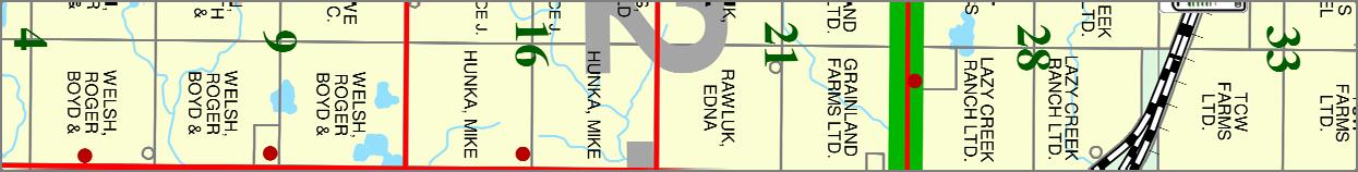
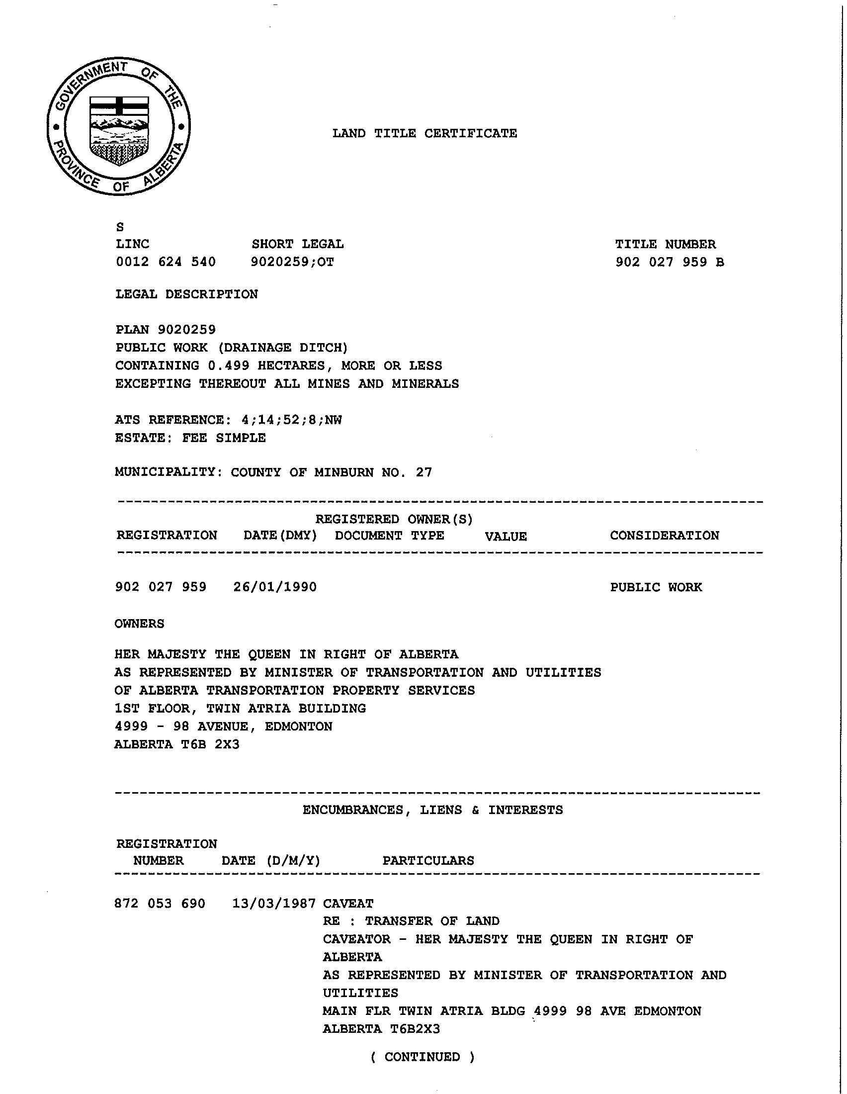
River Flat Farms Land Ltd. owns 53.02 hectares (131.02 acres) of NW 8-52-14-4 at the intersection of Highways 16 and Secondary 857 It is southeast and adjacent to the Town of Vegreville; however it is located in the County of Minburn No. 27. (Appendix #1 shows the title of the quarter section). The applicants plan to develop a Direct Control subdivision on the south west portion of the quarter section. The target market for this one lot is a heavy farm equipment dealership serving the local agricultural sector.
Map 1 – Location map shows where the subject property is located.
2 Municipal Jurisdiction
The land is in the County of Minburn No. 27 and development is controlled by the County's Municipal Development Plan (MDP), Land Use Bylaw (LUB) and County of Minburn No. 27 – Town of Vegreville Intermunicipal Development Plan (IDP).
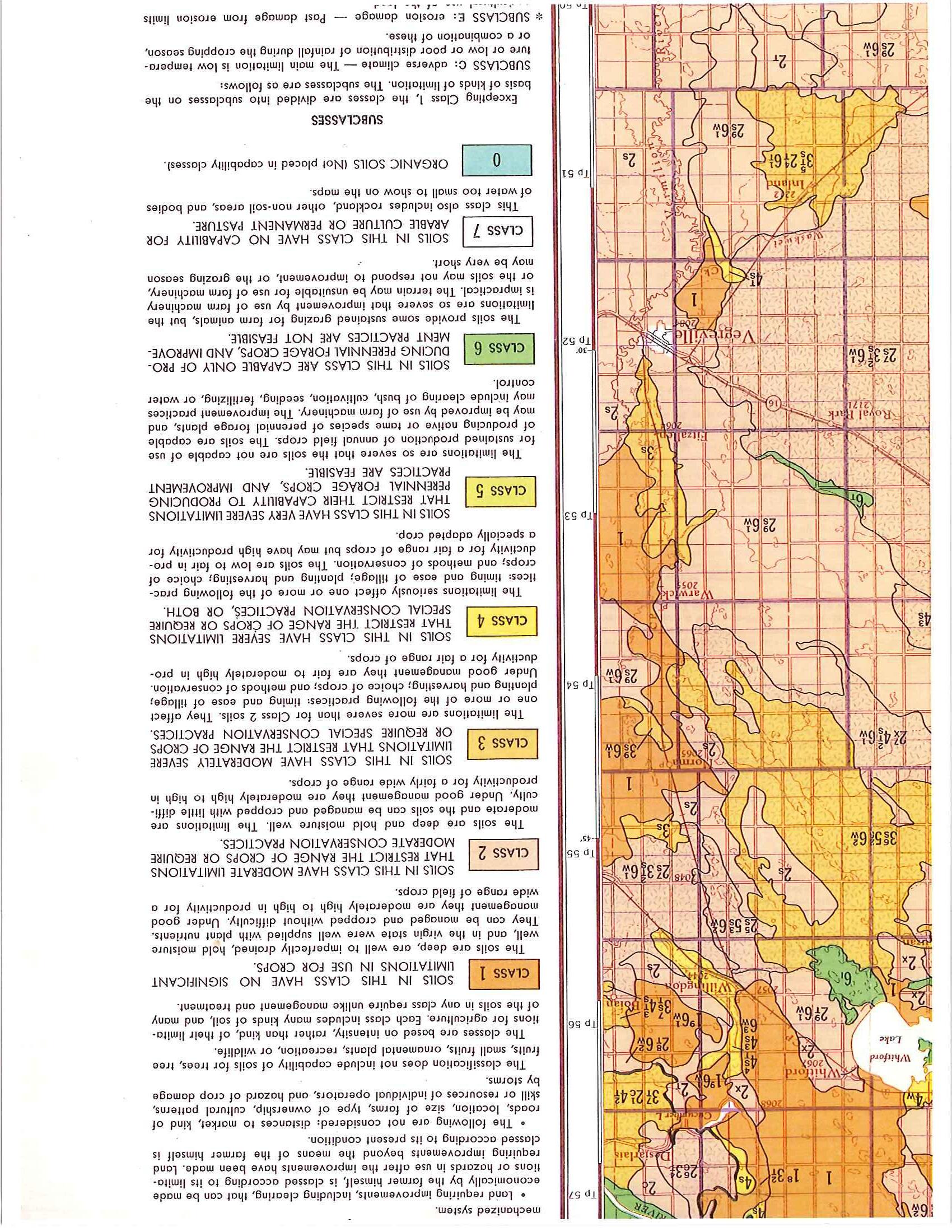
The Canada Land Inventory of Soil Capability for Agriculture (Map 83H) identified this quarter section as “Class 2: Soils in this class have moderate limitations that restrict the range of crops or require moderate conservation practices.” (See Appendix #2)
The County’s MDP identified this property on Map 2A as within the County-Town IDP and any future application shall be referred to the adjacent municipality, in this case the Town of Vegreville for comment (Section 10 of the MDP), as “the County is strongly committed to intermunicipal co-operation and planning.” Policy 10.1, page 61 of the County’s MDP.
3 Zoning
The County’s LUB identified the property zoned as Direct Control (DC) based on the first map of Schedule “A” – Land Use District Maps. The applicant will not apply for redistricting of this property and it will continue to stay as Direct Control.
In conjunction with the County-Town IDP, it labeled this property Direct Control based on Map 4C. Also, it identified the NW 8-52-14-W4 as Dryland Pasture Agricultural Land. Therefore proposal complies with County-Town IDP policy 3.6.5 “Nonagricultural development will be directed to Dryland Pasture lands. Arable lands may be considered for non-agricultural development if the County and the Town are satisfied that no Dryland Pasture lands are available to support the proposed development.” Map 6-Future Land Use of the County-Town IDP showed this property as Agriculture/Rural Development. Therefore rural development for a heavy equipment sales and services will comply with this policy in the County-Town IDP.
What is a Dryland Pasture land? In the Section 7 definition and on Page 8 of the County’s LUB: “Dryland Pasture Quarter Section – for the purposes of planning and subdivision, an area of land comprising 64.7 hectares, more or less (160 acres +), having a Farmland Assessment Value (FAV) of $25,199.00 or less based on the most recent Farmland Calculation Report.”
4 Provincial Jurisdiction
Although land use is a municipal responsibility, the County must also consider provincial regulations set out in the Subdivision and Development Regulation, Alberta Regulation 43/2002.
4.1 Sour oil and gas installations:
A proposal to subdivide land within 1,500 metres of any sour gas well or pipeline must be referred to the ERCB for comments.
There are no such installations on or within 1,500 metres of the subject property.
4.2 Other Oil and gas installations:
No setback is required from the local gas co-op's lines.
4.3 Sewer lagoons:
Certain types of development are not allowed within 300 metres of a sewer lagoon.
The two closest sewer lagoons are: One is south of Vegreville on SW 7-52-14-W4 and it is approximately 800 metres from the proposed development. The second lagoon is on SW 21-52-14-W4, it is east of Vegreville and approximately 1.96 km (1.2 miles) north east of the proposed development
The subject property satisfies the 300 metres requirement setback for sewer lagoons.
4.4 Waste disposal sites:
Certain types of development are not allowed within 300 metres of a waste disposal site, and wells for human consumption must be at least 450 metres of such sites.
The closest sanitary landfill is the Vegreville landfill located in the NW 21-52-14-W4. It is over 300 metres from the proposed development and therefore it satisfies this requirement
4.5 Proximity to highways:
A municipality must not approve a subdivision within 800 metres of a provincial highway without the prior approval of Alberta Transportation (AT).
The subject property is located at the junction of Highway 16 and Secondary Highway 857. An earlier draft of this proposal was therefore referred to Alberta Transportation, and their requirements are noted in the sections on design and highway access.
Prior to Subdivision and Development approval, Alberta Transportation’s approvals or waivers are required. (i.e. variance to Section 14 of the Subdivision and Development Regulation and roadside development permit)
4.6 Proximity to a provincial water body:
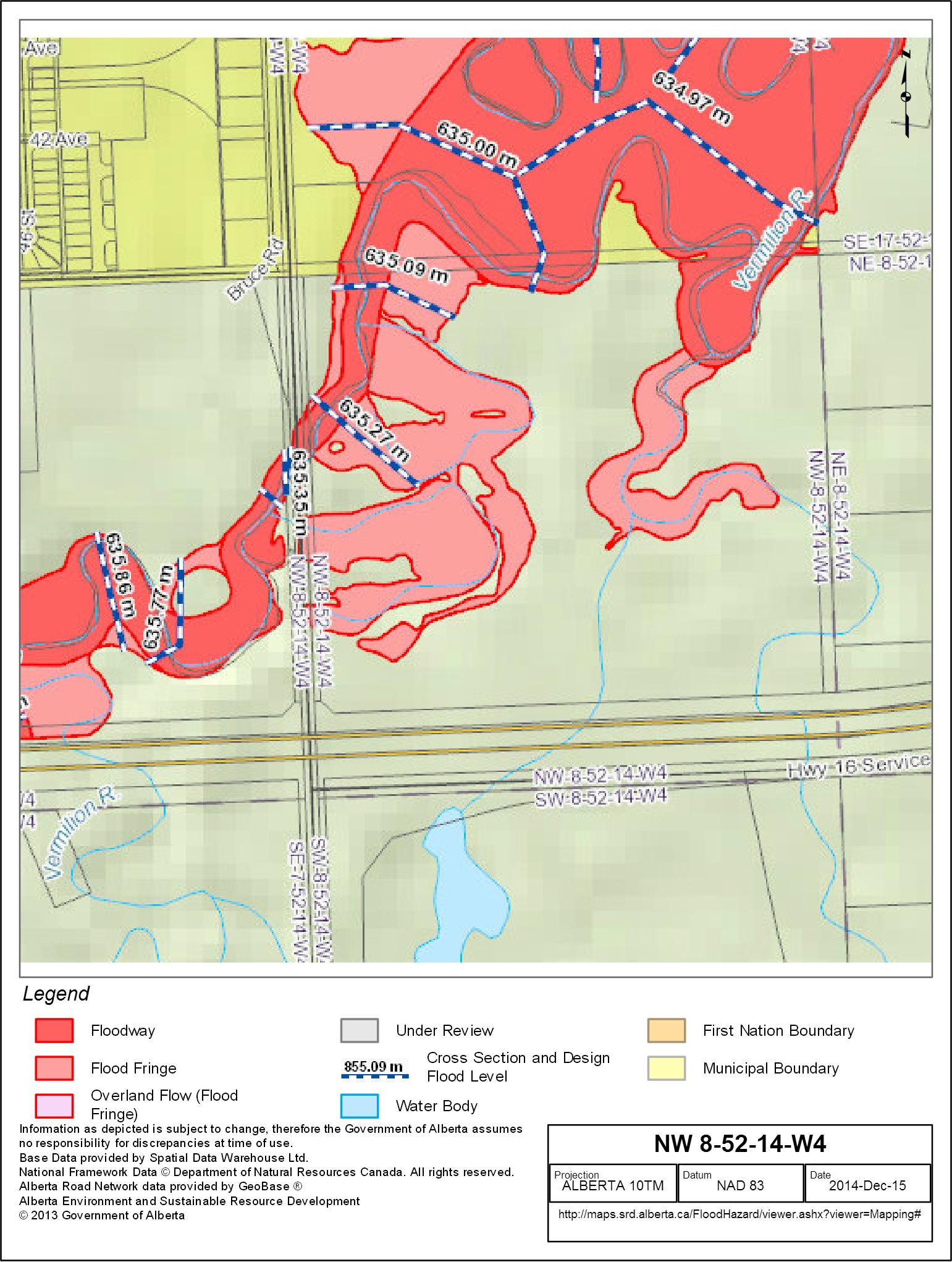
The Vermilion River is a Class C watercourse and along with its ephemeral tributaries and oxbows, the river was the primary environmental constraint in the Conceptual Scheme. Impacts to numerous local wetlands located on either side of Highway 857 also present environmental concerns in determining the future development and suitable building sites on the quarter section. Map 4 – Constraints shows where this is a constraint on the subject property.
There may be potential impacts and issues with the proximity of proposed development to the Vermilion River. If there are any conditions identified by Alberta Environment and Sustainable Resource Development then the developer will have to comply with any requirements set out by the Alberta Environment and Sustainable Resource Development. The developer must apply for any necessary approvals under the Water Act from Alberta Environment and Sustainable Resource Development prior to the construction phase.
Also, Appendix #5 confirms the location of the water course, flood way, and flood fringe.
4.7 Geotechnical Constraints:
The Vermilion River also poses high ground water concerns and geotechnical risks associated with saturated soils and yielding foundations in the surrounding area.
At the time of subdivision and/or development, the developer will demonstrate properly engineered flood protection measures which have been properly engineered by a qualified professional engineer registered to practice in the Province of Alberta.
4.8 Other senior government rules affecting development are:
4.8.1 Abandoned oil wells:
There are no abandoned oil or gas wells on the property.
4.8.2 Confined Feeding Operations:
The subject property falls within the prohibited area of Confined Feeding Operations base on the County MDP Map 3.
4.8.3 Airports:
There is a licensed airport near the property and it is the Vegreville Regional Airport, however, it is four quarter sections north of the proposed development. The proposed development is not under any landing or take-off path.
4.8.4 Historical Resources:
The Alberta government's Historical Resources Management Branch (HRMB) has the right to require a historical or archaeological assessment of land which is to be developed.
An application for a clearance letter has been applied and waiting for OPAC to process the application. The application number is 006353640.
In summary, there is nothing in any provincial regulation to prevent the development of the River Flat Farms Land property.
Map 4 – Constraints show all of the constraints in relation to the proposed development.
4.8.5 Alberta Safety Codes Act & Building Codes:
If the proposed development location on proposed lot 1 has high water tables then prior to construction the developer provides supporting documentation prepared by a qualified professional registered to practice in the Province of Alberta that demonstrates that the development of the proposed building can be made safe from hazard due to flooding and subsidence of land.
5 Present Land Uses
At present there are several land uses on NW 8 (subject property). They can be seen on Map 2 – Air Photo, a 2013 air photograph. Most of the lands on the north side are in the floodway and/or flood fringe, this was identified by Map 4a of the County-Town IDP. The Vermilion River cuts the land into multiple pieces with two pieces on the north. The two pieces are land locked with no physical and legal access. This land locked exists so there is nothing that can be done at this time with this Conceptual Scheme.
Most of the lands are being used for pasture and only some areas in the river flat are considered good production lands.
The applicant has an existing residential site on the northeast corner however that is cut off by the Vermilion River. The applicant has no plans to subdivide this residential site in the future as it is being used for rental by someone else.
The quarter section has multiple accesses: there are 5 direct accesses onto highway 857 and there is no direct access onto Highway 16 along the south side of the quarter section.
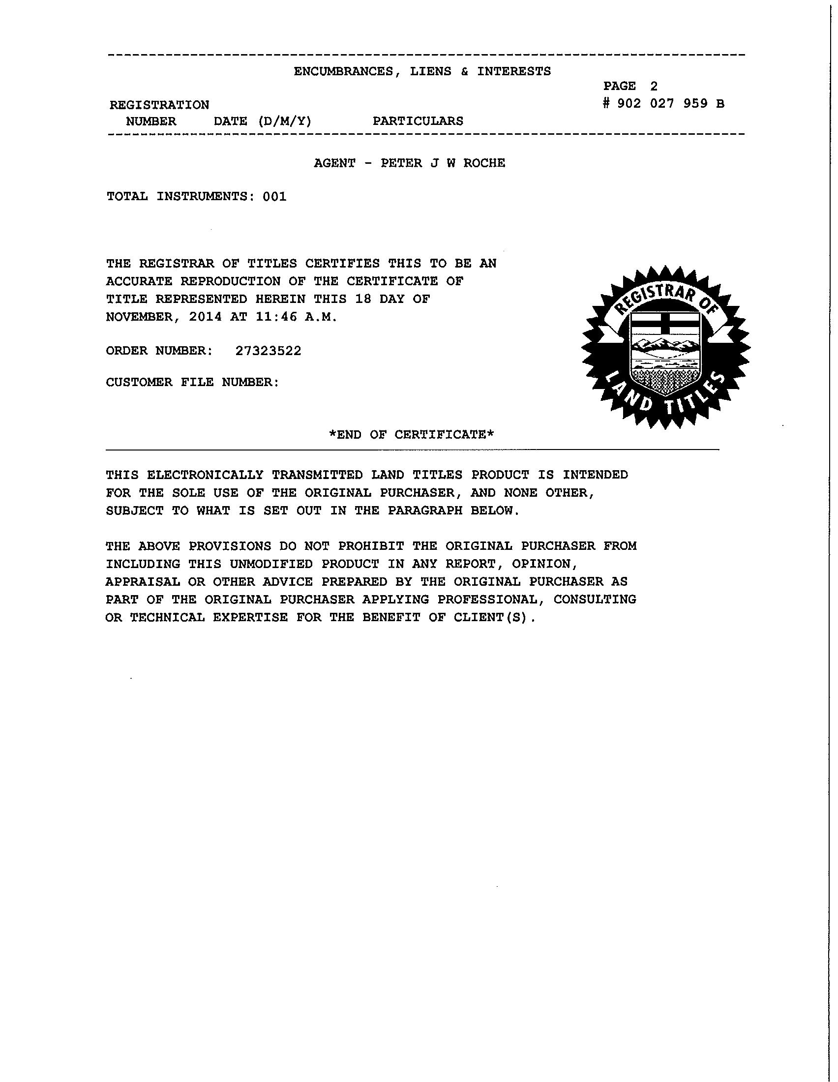
On the southeast of the quarter section, there is a drainage ditch that was registered in the 1990’s as road plan #902 0259. The title shows the drainage ditch owned by the government of Alberta and mainly the Alberta Transportation department and it is 0.499 ha or 1.23 acres in size. (Appendix #3)
Based on the County LUB map, a few properties are Rural Industrial District and they are located 2 quarter sections east or 1.6 km from the subject property.
To the north, it is Urban Reserve and it is within the Town of Vegreville. In the Town’s MDP, it identifies this land for future Natural Areas and Recreation and General Industrial
To the west and east, the land falls within the County and they are zoned as Direct Control, meaning County Council wants to have more control into what type of development will be developed in the future.
To the south, the surrounding lands are Agricultural and still being used under that purpose.
6 Conflicting Land Uses
The surrounding quarters are farmed, and the proposed use of heavy equipment sales and services lot should not conflict with the current agricultural, Urban Reserve, and Direct Control uses of the surrounding properties
7 Drainage
Map 5 - Topography shows the contour of the land. The land is highest at the southern boundary and generally slopes down towards the north with a fall of about 4 metres. The land is drained north and into the Vermilion River
The land is slightly rolling. The developers will re-grade it to create level sites, while retaining the overall south to north drainage. The low area on the north boundary will be drained at that time.
8 Proposed Development: Heavy Equipment Sales and Service
The first phase is a one lot subdivision and it will be used for Heavy Equipment Sales and Services. There will be no toxic materials to be used or stored on-site as the proposal is for Heavy Equipment Sales and Services.
Subsequent development would see uses generally aligned with those in the Rural Commercial District of the County’s Land Use Bylaw with a few exceptions.
Uses generally considered acceptable in this location that would be supported by Administration include those in the following list:
Accessory Buildings
Accessory Structure
Commercial greenhouses/plant nursery
Commercial storage
Container
Contractor service, minor
Convenience retail store
Drive through business
Food and beverage establishment, minor
Food and beverage products facility
Funeral home/chapel
Heavy equipment sales and service
Manufactured/modular dwelling sales and service
Public park
Public use
Public Utility
Public Utility building
Repair service establishment
Small animal grooming
Second hand store or establishment
Uses that may be considered on a case-by-case basis, and dependent on the specific details of an individual development proposal include those in the following list:
Agricultural service facility
Auctioneering establishment
Bus depot
Commercial School
Contractor service, major
Equipment fabrication
Funeral home/chapel/crematory
Indoor recreation establishment
Outdoor storage
Quasi-public use
Recreation vehicle storage
Retail gasoline and petroleum products sales
Surveillance suite
Wind Energy Conversion System (WECS), On-site
Uses not listed herein may be considered on a case-by-case basis, depending on the specific details of an individual development proposal, and in consideration of the suitability of the intended use to the site and surrounding area.
9
Subdivision Design
The developers believe there is a need for lots in the surrounding area of Vegreville for such businesses as truckers, plumbers, electricians, gravel haulers, agricultural equipment repairs, fertilizer sales, construction, landscaping, water haulers, and rig servicing. People wanting to operate these and other businesses now have to choose between setting up in town, or operating from a rural property like an old farm yard site, with the problems of winter snow and spring road bans.
To meet the needs of these businesses, the developers propose to subdivide the southwestern +/- 10.4 acres of NW 8 to create one lot for Phase 1. Map 6 – Lot Design shows the proposed lot boundaries and the Plan Area of this Conceptual Scheme. Exact dimensions may be adjusted to meet the particular needs of buyers.
Plan area includes only phases 1 and 2.
No direct access is required on to Highway 16 and Alberta Transportation would not allow it anyway
The main service road access to the commercial lots will be off Highway 857, approximately 120 metres north of the Highway 16 intersection. Service roads will be built on a 30 metre right of way with ten metre corner cuts. This will allow a rural cross section with drainage swales instead of curb and gutter.
At the south east corner of the proposed lot 1, there will be a temporary turnaround bulb so heavy vehicles could turn around at the end of the 30m service road. As development moves on to the next phase, the temporary turn around will be removed and turned into part of the 30m service road.
Future phase 2 is only conceptual and the size of the lots might be adjusted to meet the particular needs of buyers. There will be a temporary turnaround bulb so heavy vehicles could turn around at the end of the 30m service road at the drainage ditch
The design provides for possible future connections to the quarter to the east if needed.
10 Highway intersections
Derek Young, C.E.T. at the Vermilion office indicated to the applicant by email that AT would likely not require a Traffic Impact Assessment (TIA) or Area Structure Plan (ASP) for a single lot with the purpose of heavy equipment sales and services. Further subdivision (Phase 2) beyond the first parcel out, a TIA or ASP may be a requirement from AT for access onto Highway 857.
This email is attached as Appendix #4
In 2012, AT retained AMEC to complete a functional planning study for the future realignment of Highway 857 south of the Town of Vegreville The Executive Summary of this functional planning study for the Highway 16 & 857 interchange can be located here:
http://www.transportation.alberta.ca/projects/assets/Area_5_East/Hwy_857/ExecutiveS ummary.pdf
The short summary of the above summary is the following: There were three options presented in this study and AMEC recommended Option B, which is realigning Highway 857 to a new interchange location approximately 600 m west of the existing flyover.
This new interchange will be on the adjacent quarter section (NE 8-52-14-W4). When this new interchange is completed, the direct highway access from Highway 16 and Highway 857 will be removed. There will be direct impact on the development of this property as any traffic will have to be diverted to go to another location to get access back onto Highway 16.
Also, AT believes that eventually in the future the designation of Highway 857 on the west side of the NW 8-52-14-W4 will be removed and the local municipality will assume responsibility of this portion of the road.
11 Staging of Development
The subdivision may be created in two phases see Map 6 – Design. If so, the first phase will be a maximum of one lot of approximately 10.4 acres served by the service road. The access onto this one lot is approximately 300m from the southwest corner of the quarter section. However, phasing will be determined by market demand.
Phase 2 will include the continued construction of that 30m service road all the way east to the road plan for a drainage ditch registered under plan# 902 0259.
If future development goes ahead to the north then there might be a 30m road on the east side the first lot in Phase 1 going north bound to open further development in the future
12 Storm Water Management
Snow melt and storm runoff will increase after the land is re-graded and graveled, so in order to meet Alberta Environment guidelines it will be necessary to construct a storm water detention pond on site. The Storm Water Management plan and the size of the detention pond required should be completed by a professional engineer. This should be completed at the subdivision application stage.
The storm water pond will be constructed at the natural low point, fed by ditches in utility lot(s) and in the roads. The suggested location of the storm water detention pond is at the North West area of proposed lot 1 (see Map 5 – Topography).
13 Water supply
The type of commercial planned for this subdivision will not require large amounts of water, so there is no need for a piped municipal system. Instead, each lot will have its own well, or may truck in water offsite
Where a subdivision will create six or more residential lots on a quarter section, the Alberta Water Act requires that the developer provide a report by a professional engineer, geologist, or geophysicist, certifying that a diversion of 1,250 cubic metres of water per year for household purposes for each of the lots within the subdivision will not interfere with any existing household uses, licensees, or traditional agricultural users.
The Water Act has no such requirement for non-residential subdivisions. Instead, the developer must obtain a water licence prior to drilling a well from Alberta Environment and Sustainable Resource Development.
14 Sanitary sewer
The volume of waste water generated by Rural Commercial users will be small. It does not justify a sewage gathering and treatment system. Instead, sewage will be treated in individual septic tanks, and disposed of in tile fields, or by hauling to a municipal lagoon west of the proposed development.
The smallest lot in the subdivision will be over three acres. This is more than four times the minimum size required for on-site sewage disposal under the Alberta Private Sewer Systems Standard of Practice.
All sewer systems will be constructed in compliance with the Provincial Safety Codes, after the installers have tested them for percolation and depth to water table.
15 Fire protection
The proposed lots will be less than 3.5 km or 2.2 mile from the Town of Vegreville fire hall located on 60 Street, so response times should be good, but the fire fighters will require a source of water.
Safety code inspectors have recommended installing underground storage at the highest point on the quarter, North West corner of proposed Lot. The land will be dedicated as a utility lot. The size, type and standards of the holding tanks should be in consultation with the fire department. The tanks will be fed by a buried line from the storm water pond. The impervious subsoil, which keeps the existing farm dugout full all year, will make this a reliable source of water.
Email dated December 16, 2014 and from the County’s Fire Chief: “I do not see any fire related issues at this time. In the future, if a structure is built at this location the provisions to provide fire fighting water (i.e. dugout) would be waived due to the proximity of this location to hydrant water located in the Town of Vegreville. Our fire departments prefer to utilize clean, hydrant water in our fire apparatus if possible.”
Also, in Appendix #6 is a copy of this email.
16 Municipal Reserves
When land is subdivided into multiple lots, the municipality has the right to take ownership of certain undevelopable land as environmental reserve, and up to 10% of the developable land as municipal reserve (Municipal Government Act, sections 664 and 666).
There is undevelopable land but it is not part of Phase 1. The undevelopable land should be identified with conjunction of the floodway and flood fringe. These lands should be dedicated as Environmental Reserve (ER) for the protection of the Vermilion River in Phase 2. The ER corridor along the river, within the floodway and flood fringe acts as a good buffer and corridor for wildlife.
The undevelopable land is considered to be the exact same as identified in the MGA under section 664 (1) (a to c):
(a) a swamp, gully, ravine, coulee or natural drainage course,
(b) land that is subject to flooding or is, in the opinion of the subdivision authority, unstable, or
(c) a strip of land, not less than 6 metres in width, abutting the bed and shore of any lake, river, stream or other body of water for the purpose of
(i) preventing pollution, or
(ii) providing public access to and beside the bed and shore.
Under the Municipal Government Act (Section 653 (a)) it exempts municipal reserve (MR) being taken for the first subdivision out of the quarter section. Any MR owing should be identified in Phase 2.
The developer prefers to make a money payment in place of reserves. This is allowed by section 667 of the MGA. This money can then be used to buy or upgrade recreational land elsewhere in the County
17 Landscaping and Aesthetics
First impressions are made by people travelling the Highway 16 corridor through the County, and care should be taken to ensure new development along Highway 16 is aesthetically pleasing, adequately landscaped and screened, and not excessively illuminated.
County of Minburn will set aesthetic requirements for the style, quality, and placement of buildings, landscaping and site treatment, and the location of parking and storage areas. These Aesthetic requirements could fall under a condition of development approval.
18 Approvals requested
The owners request that the County:
Adopt this Conceptual Scheme in conjunction of the subdivision application
Appendix #1 (Applicants Title)

S
LINC
LAND TITLE CERTIFICATE
0012 615 226 132 264 995 4;14;52;8;NW
LEGAL DESCRIPTION
THE NORTH WEST QUARTER OF SECTION EIGHT (8) TOWNSHIP FIFTY TWO (52) RANGE FOURTEEN (14) WEST OF THE FOURTH MERIDIAN, CONTAINING 64.7 HECTARES (160 ACRES) MORE OR LESS. EXCEPTING THEREOUT: HECTARES (ACRES) MORE OR LESS A)
EXCEPTING THEREOUT ALL MINES AND MINERALS
ESTATE: FEE SIMPLE
MUNICIPALITY: COUNTY OF MINBURN NO. 27
REFERENCE NUMBER:132 130 765
REGISTERED OWNER(S)
REGISTRATION DATE(DMY) 22/08/2013
132 264 995
OWNERS
RIVER FLAT FARMS LAND LTD. OF BOX 1604 VEGREVILLE ALBERTA T9C 1S7
REGISTRATION
NUMBER
ENCUMBRANCES, LIENS & INTERESTS
DATE (D/M/Y) PARTICULARS
UTILITY RIGHT OF WAY 13/08/1968 222RE
GRANTEE - ALBERTA POWER LIMITED. AS TO PORTION OR PLAN:81RS "TAKES PRIORITY DATE OF CAVEAT NO. 6920OV " DATA
REGISTRATION NUMBER
DATE (D/M/Y) PARTICULARS
792 031 727
12/02/1979
922 272 051
09/09/1992
932 045 158
19/02/1993
132 264 996
22/08/2013
142 187 837
19/06/2014
TOTAL INSTRUMENTS:
006
2 PAGE # 132 264 995
UPDATED BY: TRANSFER OF UTILITY RIGHT OF WAY NO. 6699SQ"
UTILITY RIGHT OF WAY
GRANTEE - ALBERTA POWER LIMITED. "PART"
UTILITY RIGHT OF WAY
GRANTEE - MINCO GAS CO-OP LTD.
CAVEAT
RE : SEE CAVEAT
CAVEATOR - HER MAJESTY THE QUEEN IN RIGHT OF ALBERTA
AS REPRESENTED BY MINISTER OF TRANSPORTATION AND UTILITIES
C/O DIRECTOR, PROPERTY SERVICES
ALBERTA TRANSPORTATION & UTILITIES
TWIN ATRIA BUILDING, MAIN FLR. 4999-98 AVE
EDMONTON
ALBERTA T6B2X3
AGENT - PETER J W ROCHE
MORTGAGE
MORTGAGEE - CANADIAN IMPERIAL BANK OF COMMERCE. 4826-50 STREET
VEGREVILLE
ALBERTA T9C1S6
ORIGINAL PRINCIPAL AMOUNT: $540,000
CAVEAT
RE : ROADWAY
CAVEATOR - HER MAJESTY THE QUEEN IN RIGHT OF ALBERTA
AS REPRESENTED BY MINISTER OF TRANSPORTATION
C/O GOVERNMENT OF ALBERTA TRANSPORTATION,CENTRAL REGION
401,4920-51 STREET
RED DEER
ALBERTA T4N6K8
AGENT - EVAN MCPHEDRAN
CONTINUED )
THE REGISTRAR OF TITLES CERTIFIES THIS TO BE AN ACCURATE REPRODUCTION OF THE CERTIFICATE OF TITLE REPRESENTED HEREIN THIS 12 DAY OF NOVEMBER, 2014 AT 08:58 A.M.
ORDER NUMBER:
CUSTOMER FILE NUMBER: 27279400
*END OF CERTIFICATE*

THIS ELECTRONICALLY TRANSMITTED LAND TITLES PRODUCT IS INTENDED FOR THE SOLE USE OF THE ORIGINAL PURCHASER, AND NONE OTHER, SUBJECT TO WHAT IS SET OUT IN THE PARAGRAPH BELOW.
THE ABOVE PROVISIONS DO NOT PROHIBIT THE ORIGINAL PURCHASER FROM INCLUDING THIS UNMODIFIED PRODUCT IN ANY REPORT, OPINION, APPRAISAL OR OTHER ADVICE PREPARED BY THE ORIGINAL PURCHASER AS PART OF THE ORIGINAL PURCHASER APPLYING PROFESSIONAL, CONSULTING OR TECHNICAL EXPERTISE FOR THE BENEFIT OF CLIENT(S).
#2 (Soil Class of Property)
Jason Tran
From: Derek Young <derek.young@gov.ab.ca>
Sent: November-04-14 2:30 PM
To: jtran@westcentralplanning.ca
Cc: emmafried1@hotmail.com
Subject: NW 8-52-14 W4
Jason,
As per out discussion this afternoon about a potential subdivision within the NW 8-52-14 W4. Alberta Transportation would likely not require a Traffic Impact Assessment (TIA) or Area Structure Plan (ASP) for a single commercial lot should the intended be the construction of an implement dealership. Upon further subdivision a TIA and ASP may be a requirement from Transportation for the access onto Highway 857.
I had indicated to Mr. Fried that some planning would be a good idea to ensure future development of this parcel could be done with little impact to the initial lot. He should consider his future plans and subdivide to accommodate these plans. Consideration should also be given to gaining access to the future location of the Highway 857 interchange and planning for access from the NW 8-52-14 W4 to the NE 8-52-14 W4. This is where some discussion with the municipality would be important.
I have included a link to some information on our Highway 857 planning study. Please note that once the new alignment is in place the current alignment would be reverted to a local road.
Please let me know if you have any additional questions.
Derek Young C.E.T.
Development & Planning Technologist
Alberta Transportation, Vermilion District
Ph: 780-853-8284 Fax: 780-853-8270
http://www.transportation.alberta.ca/projects/east.aspx
Up-to-date road information, including traffic delays, is a click or a call away. Call 5-1-1 toll-free, visit 511.alberta.ca or follow us on Twitter @511Alberta to get on the road to safer travel.
http://511.alberta.ca/ab/en.html https://twitter.com/511Alberta
This email and any files transmitted with it are confidential and intended solely for the use of the individual or entity to whom they are addressed. If you have received this email in error please notify the system manager. This message contains confidential information and is intended only for the individual named. If you are not the named addressee you should not disseminate, distribute or copy this e-mail.
Appendix #5 (Flood Map from Alberta Environment)
MarkMessage
Move | Copy Thismessageto
Delete Reply Forward Redirect Edit as New ViewThread
Blacklist Whitelist MessageSource Save as Headers
Attachments
RE: Proposed Conceptual Scheme
Date 12/16/2014 (10:06:18 PM UTC)
From Ross Warren <rwarren@minburncounty.ab.ca>
To "admin@albertaplannow.com" <admin@albertaplannow.com>
Cc Davin Gegolick <dgegolick@minburncounty.ab.ca>
Hello Jason, December 16, 2014
Regarding the proposed Conceptual Scheme at NW 8-52-14- W4 (Dennis and Emma Fried) I do not see any fire related issues at this time. In the future, if a structure is built at this location the provisions to provide fire fighting water (i.e. dugout) would be waived due to the proximity of this location to hydrant water located in the Town of Vegreville. Our fire departments prefer to utilize clean, hydrant water in our fire apparatus if possible.
Please feel free to contact me at (780) 632-2082 or via email if you require any additional assistance with this development relating to the Alberta Fire Code and Alberta Building Code.
Ross Warren
Director of Protective Services/Fire Chief County of Minburn No. 27 rwarren@minburncounty.ab.ca
-----Original Message-----
From: admin@albertaplannow.com [mailto:admin@albertaplannow.com]
Sent: December-15-14 3:17 PM
To: Ross Warren
Subject: Proposed Conceptual Scheme
Dear Fire Chief Ross Warren,
May I have a moment of your time. I am working with Dennis and Emma Fried on their proposed Conceptual Scheme on NW 8-52-14-W4 just south of Vegreville.
They are proposing a one lot heavy equipment sale lot (on the south west corner) with a service road along the north side of highway 16.
Do you think there will be any fire related issues with this development at this location?