
Corridor Metropolitan Planning Organization
Join us in reflecting on this past years progress in creating a smarter transportation system for a better community. This addition of Connecting Communities showcases many different road, trail, Safe Routes to School, and transit initiatives that have been conducted throughout the metropolitan area.

Annual Edition 2022 www.corridormpo.com
IMAGE BY GRANT HARPER


2 /
A WORD FROM OUR CHAIR
The Corridor Metropolitan Planning Organization (CMPO) has had another busy year! The many different tasks that the CMPO has conducted include:
• Funding approximately $9 million towards regional transportation projects

• Initiating planning efforts for the public transportation and trail systems

• Receiving $5 million to bring the Tower Terrace Road project one step closer to completion
Each of these items above allows the Corridor MPO to live by our motto, “smarter transportation for a better community.” As the region enters the last days of this year’s construction season, we can reflect upon the many projects completed this year. Such projects include the Marion Boulevard Bridge, the 1st Avenue Road Projects, and a portion of the Morgan Creek Trail. These projects have provided critical connections for all modes of transportation. As the Chairperson for the Policy Board of the Corridor MPO, I look forward to seeing the impact of this year’s efforts come to fruition in future years.
Image by Liz Martin/ The Gazette Mayor of Fairfax - Bernie Frieden/ 3
TABLE OF CONTENTS
A WORD FROM OUR CHAIR 3
TABLE OF CONTENTS 4
ABOUT US 5
OUR TEAM 6
2022 COMMITTEES 7
Upcoming Projects 8
Transportation Improvement Program 9
Morgan Creek Trail 10
Marion Boulevard 12
1st Avenue Road Projects 14
Tower Terrace Road 16
Safe Streets and Roads for All 17
4 /
ABOUT
The Corridor Metropolitan Planning Organization (MPO) comprises elected officials and appointed representatives of Cedar Rapids, Linn County, Marion, Hiawatha, Robins, Ely, Fairfax, and Palo.

The MPO is tasked with reviewing and approving transportation investments in the Cedar Rapids metropolitan area.
Since its inception, the Corridor MPO’s primary activity has been preparing areawide plans to help guide orderly growth and development within the region.
The 2045 LRTP (Long Range Transportation Plan) is the federally required long-range strategy and capital improvement program developed to guide the effective investment of public funds in multimodal transportation facilities for the metropolitan planning organization area. The LRTP outlines the Vision and Fiscally Constrained Plans from which the region’s Transportation
Improvement Program (TIP), a shortrange capital improvement program for implementing road, trail, transit, and Safe Routes to School projects, is drawn. The Policy Board adopted the Plan on July 16, 2020.
Hiawatha Robins Marion Cedar Rapids Palo County / 5 Linn County US Corridor MPO Metropolitan Planning Area Boundary Cedar Rapids, Iowa MPO (Metropolitan Planning Organization)CORRIDOR MPO
Fairfax
Ely o § 380 £ ¤ 151 £ 30£ ¤ 218 £ ¤ 151 £ 30 U 150 U 94 U V 84 U 965 U 13 U 100 U 1 U 149 Corridor MPO Boundary Roads Water Corridor MPO Member Jurisdictions ± Unincorporated Linn
Unincorporated
OUR TEAM
ELIZABETH BURKE
Liz Burke’s role within the Corridor MPO is the Corridor MPO’s manager. At the MPO, you will see Liz managing the MPO’s various initiatives and plans, collaborating with our member jurisdictions to improve our transportation systems, and so much more!
Hilary Hershner’s role within the Corridor MPO is a Regional Transportation Planner. At the MPO, you will see Hilary at the Transportation Advisory Group meetings, travel demand modeling, and so much more!

ROMAN KIEFER
Roman Kiefer’s role within the Corridor MPO is a Regional Transportation Planner. At the MPO, you will see Roman at local bicycle and pedestrian meetings, working on the MPO’s Transportation Improvement Program, and so much more!

Amy Cannon’s role within the Corridor MPO is the Corridor MPO’s Administrative Assistant. At the MPO, you will see Amy corresponding with the various boards and committees within the MPO, preparing different meeting materials, and so much more!

 HILARY HERSHNER
REGIONAL TRANSPORTATION PLANNER
AMY CANNON
REGIONAL TRANSPORTATION PLANNER
ADMINISTRATIVE ASSISTANT
CORRIDOR MPO MANAGER
HILARY HERSHNER
REGIONAL TRANSPORTATION PLANNER
AMY CANNON
REGIONAL TRANSPORTATION PLANNER
ADMINISTRATIVE ASSISTANT
CORRIDOR MPO MANAGER
6 /
2022 COMMITTEES
Policy Board
Members
Representation
Bernie Frieden (Chair) Fairfax Mayor
Eric Van Kerckhove (Vice Chair) Palo Mayor
Adam Thompson Ely
Bill Bennett Hiawatha Mayor
Louis Zumbach Linn County Supervisor
Grant Harper Marion Council-Member
Randy Strnad Marion Council-Member
Tom Treharne Marion
Chuck Hinz Robins Mayor
Tiffany O’Donnell Cedar Rapids Mayor
Scott Olson Cedar Rapids Council-Member
Ashley Vanorny Cedar Rapids Council-Member
Scott Overland Cedar Rapids Council-Member
Jeff Pomeranz Cedar Rapids
Sandi Fowler Cedar Rapids
Bob Hammond Cedar Rapids
Ken Dekeyser Cedar Rapids
Roy Hesemann Cedar Rapids
Executive Committee
Transportation Technical Advisory Committee (TTAC)
Members Representation
Tom Peffer (Chair) Linn County Trails Assoc. John Witt (Vice Chair) Cedar Rapids
Mike Barkalow Marion Kesha Billings Marion Jon Bogert Palo Randy Burke Linn County Conservation Brad Ketels Linn County
John Fitch Hiawatha Scott Pottorff Ely Shane Wicks Fairfax Kelli Scott Robins Brenna Fall Cedar Rapids
Tim Mroch Cedar Rapids Ron Griffith Cedar Rapids
Mary Beth Stevenson Cedar Rapids Caroline Pauli Cedar Rapids Brad DeBrower Cedar Rapids
Doug Wilson Cedar Rapids Karin Kee Cedar Rapids
Haley Sevening Cedar Rapids
Members
Representation
Bernie Frieden (Chair) Fairfax
Eric Van Kerckhove (Vice Chair) Palo Adam Thompson Ely
Scott Olson Cedar Rapids
Bill Bennett Hiawatha
Louis Zumbach
Linn County
Grant Harper Marion
Chuck Hinz Robins
Cathy Cutler (non-voting) Iowa DOT Darla Hugaboom (non-voting) FHWA Daniel Nguyen (non-voting) FTA
CORRIDOR MPO
/ 7
Upcoming Projects


Indian Creek Trail
CeMar Trail - Phase 5

Lucore Road Pedestrian Bridge and Sidepath Tower Terrace Road 7th Avenue Reconstruction Transit Stops
Morgan Creek Trail East of the Cedar River Morgan Creek Trail Phase 3 Grant Wood Trail Development
More projects coming soon!


Edgewood Trail - Phase 3
4th Street Trail - Segment 1

Bowling Street Trail CeMar Trail - Phase 4
Lindale Trail Extension - Phase 2
Wiley Boulevard Sidepaths Cherokee Trail - Phase 4
Sac and Fox Trail Extension - Segment 1
Tower Terrace Rd Connection to I-380 Interchange
Tower Terrace Rd and North Center Point Rd Roundabout
Prairie Creek Trail - Phase 1
6th Street Southwest Reconstruction Two Medium Buses One Paratransit Bus
Tower Terrace Rd Extension
Tower Terrace Rd Connection to I-380 Interchange
Edgewood Road Transit Stops West Willow and Taft Safe Routes to School Cleveland Elementary Safe Routes to School

 City of Palo Connector Trail System
West Main Street Trail
City of Palo Connector Trail System
West Main Street Trail
8 /
Transportation Improvement Program
• 6th Street SW Reconstruction
• 4th Street Trail
• Bowling Street Trail
• Lucore Sidepath
• City of Palo Connector Trail System
• Cleveland Elementary Safe Routes to School project

• Two Heavy-duty Bus Replacements
• One Paratransit Bus Replacement
The total funding awarded between these projects was almost $9 million. You will begin to see these projects start construction between the years 2023 to 2026.
In 2022, Corridor MPO Staff and member jurisdictions were busy preparing the Federal Fiscal Years 2023 – 2026
Transportation Improvement Program (TIP). The projects awarded funding during this process include:
Funding Breakdown by
of
/ 9
Trails Transit Roads 5% Corridor MPO
Mode
Transportation 18% 30% 47% $1,514,000 Safe Routes to School $419,000 $3,953,000 $2,971,000
17181920212223242526272829303133 32 A B C D E F G H I J K L M N O P Q R S T U V W X 17181920212223242526272829303133 32 P P P P P P P P P P P P P 380 151 13 380 Cedar Valley Nature Trail CouncilSt CovingtonRd Main St 3rd Ave 35thSt 25th Ave 31stSt WinslowRd 11thSt 8th Ave29th Ave TrailCreekIndian Echo Hill Rd 74th St NE 27thSt IrishDr 44thAve CAveNE 35th Ave NCenterPointRd County Home Rd Barber St SMainAve EdgewoodRd Lindale Trail Tower Terrace Rd Grant Wood Trail 10thSt Boyson Rd NE Boyson Rd Collins Rd NE Blairs Ferry Rd Emmons St 18thAve 10th Ave 62ndSt Partners Ave LucoreRd GeodeSt Connection Ave Grant Wood Trail CedarValleyNatureTrail SpringvilleRd CreeksideRd OxleyRd Paralta Rd Bolton Manor Rd AldermanRd County Home Rd SpringvilleRd Lone Tree Rd Yates Rd Shellsburg Rd Bear Creek Rd Cedar Ridge Rd N Center Point Rd Walker Rd LewisBottomsRd StrawnRd PaloMarshRd Blairs Ferry Rd Morris Hils RdFeatherRidgeRd Tower Terrace RdNCenterPointRd Lewis RdAccess StWashington UrbanaRdRollingAcresRd Wileys Rd NCenterPointRd BettysGroveRd Campfire Rd FairchildRd WOtterRd AliceRd TroyMillsRd ReamerRd HitagaRd NAlburnettRd NMarionRd SuttonRd ValleyFarmRd RedSchoolRd 7HillsRd Hutchinson Rd Coggon Rd Paris Rd Central City Rd Iowa Rd Deal Rd Old Center Rd Roosevelt St Lafayette Rd Fishel Rd EOtterRd Arabian Rd AliceRd EOtterRd Midway Rd ScottRd AlburnettRd Burnett Station Rd Austin Rd Prairie Chapel Rd Waubeek Rd Bowdish Rd Wendy Oaks Rd Merritt Rd Hodgin Rd Big Spring Rd Burr Oaks Rd Gracey Rd WhittierRd StoneRd JordansGroveRd HindmanRd GillmoreRd Bice Blvd HollenbeckRd SuttonRd Main Ridge Rd Melrose Rd Blodgett Rd Lyman Rd StPetersRd White Rd Midway Rd OtterRd Hagerman Rd Greens Grove Rd Cedar Heights Rd Cummings Ford Rd MohlerRd Quail Ridge Rd StandleaRd Wickiup Hill Park Lowe Park Pleasant Creek State Park Boyson Park Guthridge Park Wakpicada Park Pinicon Ridge Park Goose Pond Matsell Bridge Natural Area Cedar River Wapsipinicon River Hitaga Sand Ridge Prairie Preserve Wapsipinicon River Bu alo Creek Park South Troy ParkAlburnett Center Point Central CityCoggon Prairieburg Walker Robins Palo Hiawatha Marion Springville Toddville Lafayette Waubeek Troy Mills CAveExt Midway P P P P P P P 380 O Ave NW Bever Ave SE BowlingStSW 8th Ave SW Otis Rd SE 3rdSt 3rd Ave Cottage Grove K Ave NE CSt MemorialDrSE ForestRd B Ave NW 16thSt ShaverRd EllisAveNW EllisTrail Ave1st 12th Ave SE 10thStSEAve2nd 21stSt 1stSt 4th Ave 15thSt AveE RdRockford Ave NW Cedar Valley Nature Trail (CVNT) CVNT CVNTTrailCeMar CollegeCoeRdNE NE H Ave NE CenterPointRd OaklandRd Ave16th Bever Park Ellis Park Mount Trashmore Cedar Lake Van Vechten Park Prairie Park Fishery ElyMarion Hiawatha Downtown Cedar Rapids 2021 Trail Map of the Corridor MPO Region
HillcrestSt
12345678910111213141516 A B C D E F G H J K L M N O P Q R S T U V W X 12345678910111213141516 Iowa River Iowa River P P P P P PPP P P P P P P P P P P P P P P P P P P P P P P P P P P P P P 30 380 151 30 30 13 1 100 100 76th Ave SW Williams Blvd 42nd St NE 29th St NE Beverly Rd SW CeMar Trail 1stAveE O Ave NW EdgewoodRdSW 34thStSE E Ave NW TrailFox&Sac WenigRdNE EastPostRd Wilson Ave18thStSW WileyBlvd Bever Ave SE BowlingStSW 8th Ave SW 15thSt 33rd Ave SW Otis Rd SE Pioneer Ave SE 3rdSt 3rd Ave Cottage Grove Ave SE OaklandRdNE 40th St NE KirkwoodBlvdSW 22ndSt K Ave NE TrailEdgewood SeminoleValleyRd CStSW MemorialDrSE StoneyPointRd ForestRd C B Ave NW Gordon Ave 16thSt ShaverRd EllisAveNW E Cemetery Rd Wright Brothers Blvd 31stSt Cherokee Trail Mt Vernon Rd SE EllisTrail Sac & Fox Trail Edgewood 1st Ave W CedarValleyNatureTrail 6thStSW Highway965 Highway 382 W Sovers St 180th St NE MehaffeyBridge Rd RacineAveNE Highway1 Sutliff Rd NE WhiteOakAveNE 120th St NW VanderbiltSt 80thStSW
37th Ave SW 12thStSW 66th Ave SW Kirkwood Pkwy Tower Rd SW CStSW ElyRdSW 44thStSE RosedaleRdSE Trailridge Rd 12th Ave SE 10thSt Ave2nd 21stSt 1stSt Johnson Ave JacolynDr WestPostRd Coldstream Grande Ave Creekside Secrist Rd Alderman Mt Vernon Rd SE 1stStW Lisbon Rd W Main StNWashingtonSt 32nd St NE 15th Ave SW 120th St NE 110th St NE 140th St NE Sutliff Rd NE LinnGroveRd YeisleyRd SpringvilleRd MuseumRd E Bertram Rd Old River Rd W Main St Walford Rd Linn Johnson Rd NW 140th St NW Southview Rd SW Ellis Rd FAve NW Lone Tree Rd LinnBentonRdSW StPatricksRdSW MapleGroveRdSW TisselHollowRdSW 60th Ave SW BentonLinnRd SisleyGrovewRdNW Martelle Rd Elbow Creek Rd Martin Creek Rd Linn Ridge Rd Abbe Hill Rd IvanhoeRd Prairie School Rd 7 Sisters Rd VegaRdNE PleasantHillRd JappaRd RogersGroveRd PalisadesAccessRd PolkAveNE Light Rd Day Rd SpanishRd ClubRd SandyBeachRdNE LakeManorRdNE Vista Rd NaplesAveNE Seneca Rd NW Morgan Valley Rd SW YoungRd GibneyRd Wanatee Park Bever Park Seminole Valley Park Ellis Park Noelridge Park Jones Park Indian Creek Nature Center Beverly Park Morgan Creek Park Faulkes Woods Mount Trashmore Fairfax City Sports and Park Complex Kirkwood Community College Eastern Iowa Airport Prairie Park Fishery Palisades-Kepler State Park South Cedar Park Lake McBride State Park Coralville Lake Hawkeye Wildlife Area Cedar Lake Cedar River Cedar River Cedar River Cheyenne BMX Park Thomas Edison Blvd Sugar Bottom Cedar Rapids Walford Solon Bertram Mt. Vernon Lisbon Fairfax Shueyville Swisher Ely Sutliff GreencastleAveNW Gravel Road Wide Paved Shoulder Unpaved Trail Paved Trail Bike Lane Future Paved Trail Future Bike Lane P Trail Head Bike Friendly Street Bike Shop Fix-it Station with Air 0 2 4 1 Miles N Legend Mountain Biking Paved Road
Morgan Creek Trail
View of Morgan Creek Trail Bridge coming from the newly constructed Morgan Creek Park south area.
JURISDICTION
After many years of planning, designing, and engineering, construction of the Morgan Creek trail has begun. In 2021, the portion of Morgan Creek Trail through Morgan Creek Park was completed. This winding trail allows users to view prairie, wooded areas, and Morgan Creek.

Upon the completion of this segment of Morgan
Creek Trail, the Linn County Conservation Board moved the park entrance to E Avenue Northwest. Other amenities at the park entrance include restrooms, a state-of-theart playground, and various shelters. By providing such amenities, the Linn County Conservation Board has ensured that all visitors can enjoy the park.
12 /
MEMBER
Future extensions of the Morgan Creek Trail have been phased out into different segments. Phasing allows for easier project management and budgeting. Currently, the trail segment from 42nd Street Northwest to the Cedar River is planned to begin construction in 2023. The trail segment from Morgan Creek Park to Covington Road is funded. A study is being conducted about how to cross the Cedar River. Lastly, the Linn County Conservation Board is actively pursuing funding for the trail segment from Covington Road to the Cedar River.
As the Morgan Creek Trail continues to be constructed, the Corridor MPO is thrilled to see the public utilize and enjoy the trail. Such projects allow many community members to access essential public amenities such as park space. Community members can enjoy nature in many ways by providing access to these areas.

The images above and below are views from approaching and using the bridge at Morgan Creek Park. This bridge provides a safe pedestrian crossing over Morgan Creek. The bridge allows users to continue their journey through Morgan Creek Park and eventually to the Cedar River.

CORRIDOR MPO
/ 13
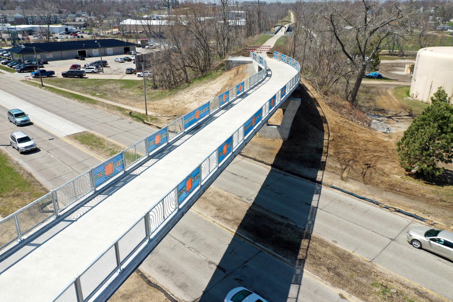
Marion Boulevard Bridge
Aerial image of the new Marion Boulevard Bridge

JURISDICTION
Historically those driving to Marion along Marion Boulevard passed underneath an average railroad bridge. Upon the railroad’s closure through Marion, planning efforts began about what to do with the areas that used to be a railroad. One area of interest was the railroad bridge. Through community engagement and planning efforts within the City of Marion, it was decided that the old railroad bridge would be
replaced with a pedestrian bridge. The new pedestrian bridge would allow for a critical connection between Marion and the surrounding communities and an art installation that welcomes all visitors to Marion.
In July of 2022, the City of Marion held a ribbon cutting for the new bridge. During the ribbon cutting, a strong message shared by the City of Marion, the City of Cedar
 IMAGE BY GRANT HARPER
14 /
MEMBER
Rapids, and the Corridor MPO was the importance of collaboration and regional connections. The Marion Boulevard Bridge provides Uptown Marion with connections to the Lindale, Boyson, Indian Creek, and CEMAR Trails. With current initiatives to complete the Lindale, Indian, and CEMAR Trail, trail users will gain access to all areas within the metropolitan area.
Upon the Iowa Department of Transportation’s acceptance of the Marion Boulevard Bridge, the City of Marion will install the gateway art pieces. These Gateway pieces will be made by the local artist Cara Briggs Farmer. Within the Gateway, there will be pillars, lighting, and the paneling has already been installed.
The Corridor MPO has been thrilled to see the public utilize and enjoy the Marion Boulevard Bridge. Such projects provide crucial connections to the regional community. Community members can access essential destinations and regional economic centers by implementing these connections. The Marion Boulevard Bridge will only grow in importance in upcoming years as the regional trails system continues to grow and connect.
The images both below and above are of the new Marion Boulevard Bridge. This bridge provides a crucial connection for trails between the City of Marion and the rest of the metropolitan area’s trail systems.

CORRIDOR MPO
IMAGE BY GRANT HARPER/ 15
1st Avenue Projects
IMAGE OF 1ST AVENUE UNDERPASS FOR THE CEMAR TRAIL

MEMBER JURISDICTION
Over the last couple of decades, the CEMAR trail has grown from a concept into a regional trail backbone for the Corridor MPO’s trail system. One of the most recent projects that have been accomplished for the CEMAR trail is the 1st Avenue Road project. Within this project, a trail underpass was constructed to allow for a safe pedestrian crossing at 1st Avenue. By
implementing an underpass like this, both pedestrian and motorized traffic are to move uninterrupted. In doing so, safety and congestion concerns are addressed.
Future connections of the CEMAR trail will extend past 3rd Avenue SE in Cedar Rapids and connect to the trail by Menards in Marion. To accomplish this extension, the City of

16 /
Marion is currently working on easements that would allow the future construction of the trail extension.
Upon completing the CEMAR and Lindale trails, trail users can complete an approximately 15-mile loop through Cedar Rapids and Marion. Sights along the way will include the newly reinvigorated Cedar Lake area, Mt. Mercy’s Campus, Faulks Heritage Woods, and many others.
With the CEMAR trail being a crucial link between two of the most populated municipalities in the metropolitan area, the Corridor MPO is optimistic about seeing the final connection of the CEMAR trail completed. By doing so, community members can connect with each other and vital community resources. The CEMAR trail will be a regional resource that all will enjoy.
The images above and below showcase the pedestrian underpass on 1st Avenue in Cedar Rapids. This underpass allows for safe usage of the CEMAR Trail as users move from Cedar Rapids to Marion or vice versa.


CORRIDOR MPO
/ 17
Tower Terrace Road
IMAGE OF BOX CULVERT FOR TOWER TERRACE ROAD EXPANSION FROM MARION TO CEDAR RAPIDS

MEMBER JURISDICTIONS
As the Tower Terrace and I-380 Interchange project construction continues, the Corridor MPO, Hiawatha, Robins, Cedar Rapids, Marion, and Linn County continue to work to secure funding for the remainder of the roadway west to Highway 13.

In early 2022, the MPO secured $5M in Community Project Funding for engineering and right-of-way acquisitions for the
project. While we were hopeful for a RAISE grant funding award this year, we remain committed to the project. The MPO, and our project partners, look forward to future opportunities to leverage outside funding and accelerate the project. We will continue working together as opportunities become available.
 IMAGE BY GRANT HARPER
18 /
Safe Streets and Roads for All
From 2016 to 2021, the Cedar Rapids Metropolitan area had 68 vehicle-related deaths. Due to these tragedies and commitment to creating safe transportation systems, the Corridor MPO will apply for the Safe Streets and Roads for All funding opportunity to discover why these accidents occur and how to stop them from happening again.
Is the Corridor MPO’s 5-year transportation system’s annual fatality rate
Is the Corridor MPO’s goal for fatality rates with the adoption of a “Vision Zero” policy4.918 0.0
In 2022, the United States of America Department of Transportation (USDOT) created a funding program named Safe Streets and Roads for All. The Safe Streets and Roads for All program allows the federal government to push the Vision Zero initiative forward. In previous years, there has been an increase in pedestrian fatalities. By
funding communities to study their transportation system and enact solutions to areas of improvement, the Federal Government and local communities are hopeful to see these tragedies significantly reduced.
On September 15th, the Corridor MPO applied for $350,000 to conduct
a transportation system safety study throughout the Corridor MPO region. This study will analyze motor vehicle, pedestrian, and other transportation systems. If awarded funding, the Corridor MPO can apply for additional funding to enact the projects identified within the transportation system safety study.
CORRIDOR MPO
/ 19
