Fostering Resilience: Supporting Food Access and Production in Pittsfield, MA
FOSTERING RESILIENCE
Supporting Food Access and Production in Pittsfield, MA
A community food system study prepared for the City of Pittsfield, Berkshire Bounty, and Roots Rising
Reed Bryant | Ryan Pagois | Prithvi Rajesh
The Conway School Winter 2025
ACKNOWLEDGEMENTS
We would like to extend our gratitude to the many people who supported this project along the way. A special thank you to our core client team: the City of Pittsfield, Berkshire Bounty, and Roots Rising. Specifically, we thank Justine Dodds, Morgan Ovitsky, Lauren Piotrowski, and Jessica Vecchia for their time, insight, support, and guidance throughout the process. We also thank the community members who took time to speak with us or fill out our survey, and to the community stakeholders who agreed to be interviewed for this study and offered up their invaluable insight and experiences with us. Your dedication to your community is inspiring and energizing.
We thank the faculty and staff at the Conway School, as well as students, past and present, who supported us throughout this process with their encouragement, guidance, and inspiring hard work.
We would also like to acknowledge the critical role that immigrants, both documented and undocumented, play in upholding food systems across all scales. Their continued exploitation as workers and their separation from healthy and affordable food is systematic and unjust.
STOCKBRIDGE-MUNSEE INDIGENOUS LAND ACKNOWLEDGEMENT
It is with gratitude and humility that we acknowledge that we are learning, speaking, and gathering on the ancestral homelands of the Mohican people, who are the indigenous peoples of this land. Despite tremendous hardship in being forced from here, today their community resides in Wisconsin and is known as the Stockbridge-Munsee Community. We pay honor and respect to their ancestors past and present as we commit to building a more inclusive and equitable space for all.
This land acknowledgement is pre-approved by the Stockbridge-Munsee Community Tribal Council.
EXECUTIVE SUMMARY
In recent years, the COVID-19 pandemic and the rise of food and housing costs have exacerbated existing inequities in food systems across scales. The city of Pittsfield has witnessed the heightened needs of its residents first-hand, with the demand for emergency food assistance in the city increasing by 86% since 2021 (Food Bank of Western MA). The Pittsfield community is already hard at work addressing disparities in food access, with a network of programs and services providing emergency food to Pittsfield’s most vulnerable populations. However, in the face of unpredictable global supply chains and changing climate conditions, the resilience of Pittsfield’s local food system has come to the forefront of conversations around equitable and enduring food security for all Pittsfield residents.
Currently, many Pittsfield residents have incomes below the state median, especially those living in downtown neighborhoods, and rely heavily on food assistance programs to make ends meet. Many residents also do not have personal vehicles and are located far from retail locations that offer highquality, fresh food. These economic and spatial barriers contribute to heightened food insecurity in neighborhoods like West Side and Morningside. Efforts are underway to address these inequities and foster a food system that is resilient, promotes food sovereignty, and provides residents and communities with control over their own food production to supplement their access to healthy and affordable foods.
This study analyzes existing infrastructure, organizations, and services to identify gaps in, and barriers to, equitable food access and production. With support from community stakeholders, previous and ongoing research, and spatial analysis tools, this study provides recommendations for the City and local non-profits to foster resilience in the local food system and promote food sovereignty among Pittsfield residents. These recommendations address food access at retail and emergency food locations, as well as commercial and community food production. They include processes for identifying locations for new grocery store locations and cold storage facilities, and city-owned land that might be suitable for agriculture and community gardens.
INTRODUCTION
PROJECT OVERVIEW
The Pittsfield community is already hard at work addressing disparities in food access. A robust network of City and nonprofit programs and services is working to fill gaps in fresh food access through local food production, the emergency food network, and advocacy around food assistance programs.
Previous studies on food systems in Berkshire County and across Massachusetts provide research, goals, and progress that have benefited this report. The core team for this project includes the City of Pittsfield Department of Community Development and partner non-profits Berkshire Bounty and Roots Rising. The goal of this project is to identify gaps in, and barriers to, food production and food access in Pittsfield. With the guidance of food system experts and previous research and data collection efforts, this report was written by a group of graduate students from the Conway School, and seeks to explore how existing programming and infrastructure can be leveraged to build a more resilient food system in Pittsfield through community-led food production and equitable food access.
The core project team and community stakeholders reported that food insecurity has increased dramatically in the past several years in Pittsfield. Conflating economic and social challenges, including the COVID-19 pandemic, rising housing costs, inflation, and political tensions, serve as the impetus for this timely study.
This report was supported and guided by the engagement of the Pittsfield community and the core project team. A tabling session at the Pittsfield Farmers Market and an online survey active throughout the project duration allowed for Pittsfield growers, sellers, shoppers, and residents to share their experience with the Pittsfield food system, and what they perceive as both assets and challenges to food access in their community. While survey responses were low, insight into Pittsfield’s food system was further provided by a range of community stakeholders that span various sectors, including government, nonprofit, agriculture, emergency food distribution, and retail. The majority of stakeholder interviews were conducted
over Zoom, and ranged from 30 to 60 minutes in length. Key takeaways and challenges identified by community members will be presented in their respective sections later in the document.
Organizations interviewed for this report include:
• American Farmland Trust
• Berkshire Agricultural Ventures
• Berkshire Bounty
• Berkshire Community Land Trust
• Berkshire Conservation District
• Berkshire Funding Focus
• Berkshire Grown
• The Christian Center
• The City of Pittsfield
• The Food Bank of Western MA
• Guido’s Fresh Marketplace
• Habitat for Humanity
• Hancock Shaker Village
• Massachusetts College of Liberal Arts
• Massachusetts Department of Agricultural Resources
• Massachusetts Department of Rural Affairs
• Mixed Faces Wild Spaces
• Red Shirt Farm
• Regenerative Design Group
• Roots Rising
• South Congregational Church
The following analyses and recommendations are not comprehensive nor are they viable without continued community engagement. Language translation should be prioritized in order to provide equitable opportunities for community feedback, and the voices of marginalized groups should be uplifted due to their active involvement in, and vulnerability to, food system reforms and policies.
DEFINING A FOOD SYSTEM
There are many components to a food system, which spans all stages of food production, processing and packaging, distribution, access, consumption, and waste management. It encompasses the policies, programs, infrastructure, and resources that allow each stage to function. Food systems exist at a variety of different levels, spanning local, regional, and global scales. These systems have a wide range of stakeholders, including governments, corporations, academia, and individual consumers. Because of the breadth and scale that food systems reach, they have immense social, economic, and environmental implications, and are intricately tied to historical and systemic forces that shape communities today. Nearly 800 million people worldwide experience chronic hunger, many of whom live in low-income countries or are socially or economically isolated (World Food Programme). These inequities also exist at the local scale in the United States, with low-income communities and people of color experiencing higher rates of food apartheid (NRDC), the systemic injustices resulting in communities devoid of healthy and affordable food options (Regeneration).
When structural barriers to healthy food access are mitigated or removed by organizations, governments, or individuals, it is known as food justice (FoodPrint). However, when the people have control and decision-making power over their own food and agricultural systems, with the right to culturally appropriate and nutritious food produced in ecologically sound ways, it is known as food sovereignty (USFS). This study acknowledges that healthy and affordable food is a human right, and access to such foods should not be at the mercy of market demands or corporate profits.
In this study, food production and food access are prioritized as key aspects of a resilient food system in Pittsfield, but the equitable and ecological functionality of all aspects of the food system are required to build a system that works for both people and environment. Holistic interventions are needed to repair severed connections between people and food.
ECONOMICJUSTICE ENVIRONMENTALSTEWARDSH
INDIGENOUS LAND RELATIONS
The following information is paraphrased from the Stockbridge-Munsee Band of Mohicans’ website.
The Mohicans are descendents of a people that traveled hundreds of miles eastward over many years, settling in rich river valleys across the continent while others moved on. The people now known as the Stockbridge-Munsee Band of Mohican Indians settled in the Housatonic River Valley where the people gained intricate knowledge of the local ecology, naming themselves The People of the Waters that Are Never Still. They were sometimes referred to as the River Indians by outsiders. They built their lives around the river and its surrounding woodlands. Others continued on and built a home around the Delaware River, farther south. The Mohican/Munsee territory extends across six northeastern states. While never formally part of a tribal confederacy, the Mohicans were relatives and allies with various tribes across the northeastern continent, and never forgot their origins.
In the Berkshire Region, the Stockbridge/Munsee people stewarded a land rich with food. The men hunted game in the woodlands and fished for trout, shad, and herring, and oysters were harvested in the banks of the river. Women maintained gardens of squash, beans, and corn. They harvested berries and nuts, which were abundant in the landscape. Meats, fruits, and vegetables were dried and preserved for winter, while fish was smoked and stored in deep, grass-lined pits to sustain the people during the cold months ahead. In the spring, maple trees were tapped and sap was turned to syrup, and the first seeds of the year were planted. The food calendar was central to the Mohican way of life, and the bounty of the landscape shaped tradition and celebration.
This rich culture around food and sustenance was made possible by the gifts of the land and the Mohicans’ stewardship and respect for the natural world. Their numbers diminished in the 1700s due to contact with European colonists resulting in conflict and disease, and the Mohican people underwent a series of forced removals westward. Today, the Stockbridge-Munsee Band of Mohican Indians resides in northeastern Wisconsin and remains a proud, sovereign nation with a rich history that continues to evolve and grow. In 2023, the tribe purchased 351 acres of land on Monument Mountain in Stockbridge, MA, returning the land to tribal stewardship and restoring ties to the Berkshire region after more than 200 years of separation (The Berkshire Eagle 2023).
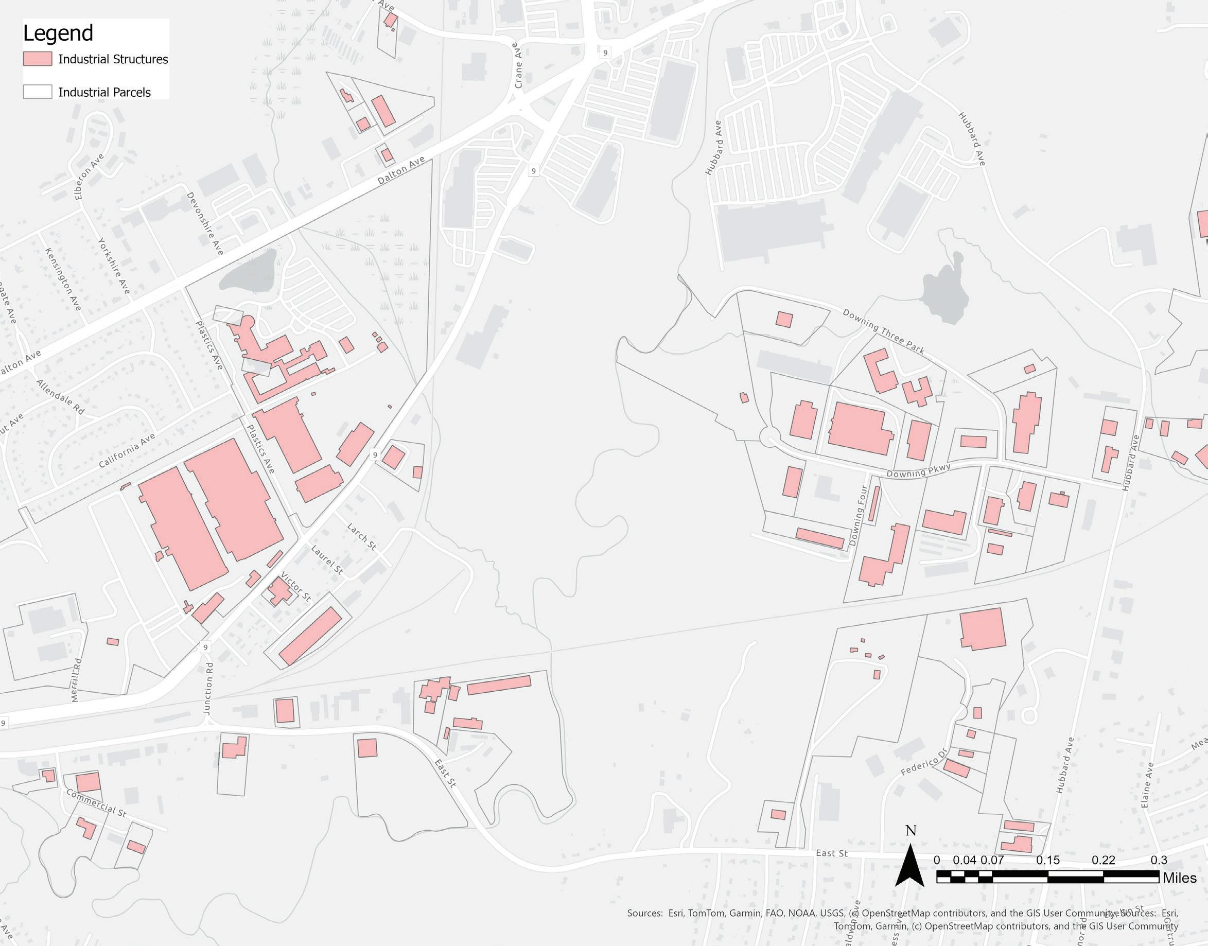
AGRICULTURAL & INDUSTRIAL HISTORY
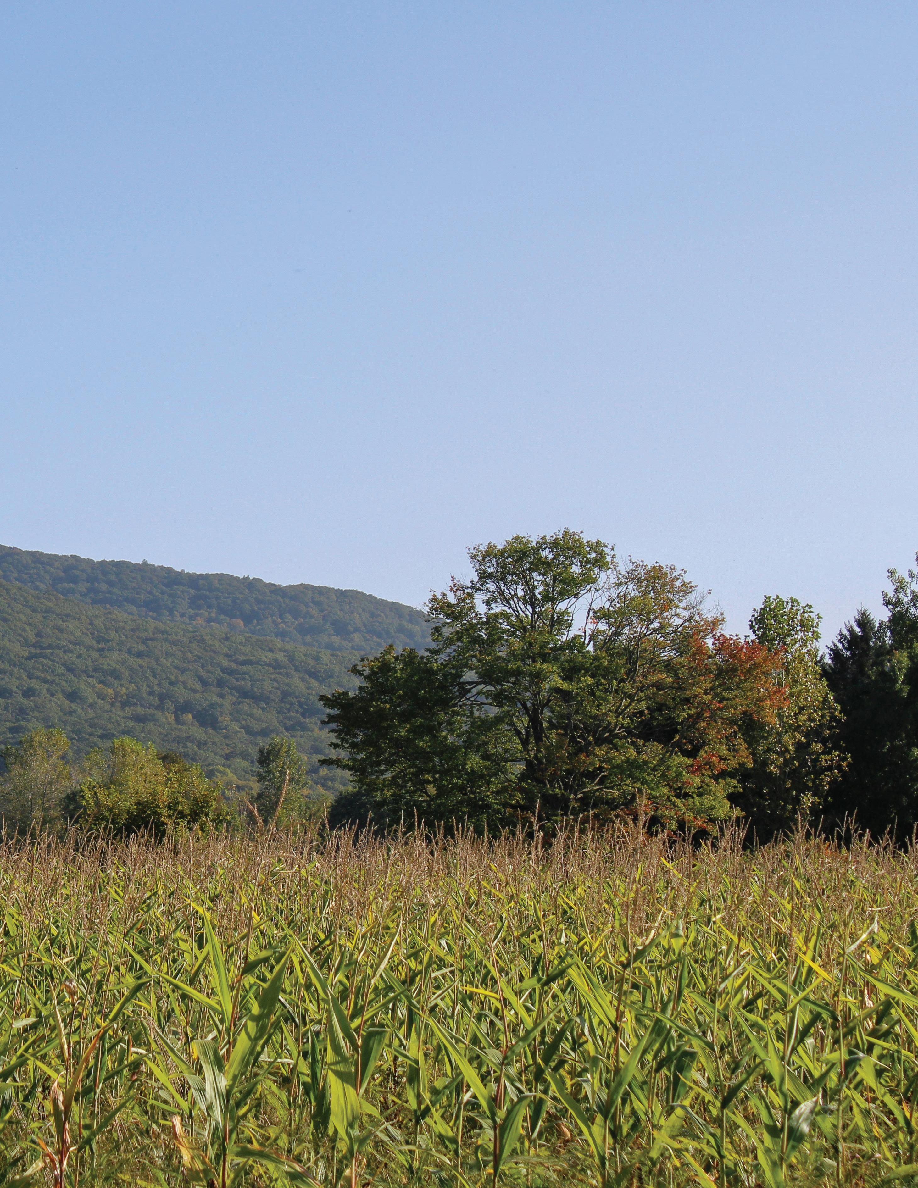
The area now called Pittsfield lies at the western border of Massachusetts, nestled in the Berkshire Mountains among landscapes with ecological and human histories that transcend its recent colonial past.
Since its colonization in the 1700s, Pittsfield has been a center of commerce, shape-shifting to adapt to emerging industry and continuously redefining itself. At its roots, however, Pittsfield is an agricultural community. Prior to its status as a City, Pittsfield was a small farming township fed by the many mountain streams that flowed through the fields and ultimately fed the Housatonic River. With the Revolutionary War and the introduction of Merino sheep from Spain, Pittsfield’s population exploded and it became the center of American Merino wool production, while mills popped up on the waterways to produce lumber, paper, and textiles. Pittsfield’s relationship with the landscape and its network of waterways provided the power it needed to become a manufacturing powerhouse and fueled its population growth. Agricultural lands remained, surrounding an increasingly developed and industrial downtown.
The introduction of electricity presented another opportunity for Pittsfield. The relocation of the Electric Manufacturing Company, the forerunner of
General Electric (GE), helped bring Pittsfield’s manufacturing sector into the twentieth century, and its population grew to 50,000 by 1930 with the availability of manufacturing jobs.
GE Advanced Materials (Plastics) was Pittsfield’s largest employer throughout the first half of the twentieth century. When GE left in 1987, the workforce that once topped 13,000 was reduced to just 700 local jobs, leaving an economic vacuum in its wake. When jobs left the city, the young jobseekers followed, Pittsfield’s population started its decline, and wealth began leaving the city (City of Pittsfield). GE also left behind extensive soil and water contamination that has traveled all the way to the Long Island Sound from Pittsfield (EPA).
Today, Pittsfield is experiencing heightened social and economic challenges that are common among American post-industrial cities. With poverty rates above the national average and farmers struggling to make ends meet has fueled food insecurity. What is the role of farming and food production in Pittsfield’s future, and how can food access be improved for community members who need it most? Drawing on Pittsfield’s track record of diversification and rediscovery throughout its history, how can the City build its future around a resilient and equitable food system?
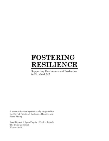
Birds-eye view of Pittsfield circa 1899. Source: Library of Congress.
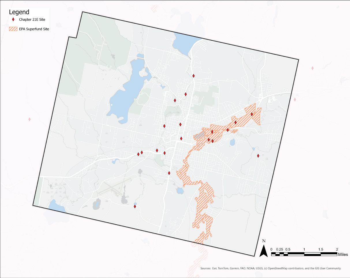
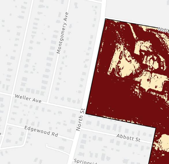
PCB CONTAMINATION
Pittsfield’s peak industrial period left behind lasting environmental effects. Particularly, in the years between 1935 and 1977, General Electric (GE) polluted the Housatonic River with over 31 million pounds of polychlorinated biphenyls (PCBs) and other man-made organic and industrial chemicals which were byproducts of its manufacturing operations (Carey 2022). PCBs contaminated the soil in the city as well as soil and water throughout the course of the Housatonic River, extending from Pittsfield to Long Island Sound in Connecticut. The pollution has led to the designation of two Superfund sites and clean-up teams that are actively working on soil remediation, water filtration, and building public awareness to increase diligence in contaminated areas. PCB cleanup in Pittsfield and the Housatonic River has been underway since 2000 (EPA).
PCBs are chemicals that have the potential to linger in the soil for indefinite amounts of time. The EPA has identified carcinogenic and non-carcinogenic risks from exposure to soil along the river, consumption of area fish and waterfowl, and consumption of agricultural products grown on farms and residential or community gardens (ibid.).
PCB contamination is not limited to superfund sites in Pittsfield. Between 1940 and 1970, GE donated PCB-contaminated soil to towns and cities across
Full extent of GE/Housatonic River Superfund Site. Source: EPA Cleanups: GE-Pittsfield/Housatonic River Site
Areas in green represent sites where soil remediation has been completed. Source: EPA Cleanups: GE-Pittsfield/Housatonic River Site
Berkshire County as “clean” fill, resulting in the distribution of PCBs across Pittsfield and the wider county, some of which went to school and residential lots, putting residents at risk of an array of health conditions (The BEAT). A 2022 study found that the median PCB levels in indoor air and human blood in Pittsfield is four times higher than the national average (Casey 2022), and the Morningside neighborhood, adjacent to the former GE site, has a life expectancy more than 12 years less than more affluent neighborhoods in Pittsfield (Polito 2020). There are numerous lawsuits with GE across Berkshire County, both active and settled, attempting to address the issue (WAMC).
According to the EPA, consumption of home garden produce (at a soil concentration of 2 mg/kg or less) is not a health risk, even in combination with soil exposure during gardening activities. Risk from consumption of wild plants is unlikely because consumption rates are assumed to be lower than for home garden produce (EPA). Thorough soil testing prior to the start of any in-ground food production is strongly advised, however home test kits can be difficult to find, and lab testing can be expensive, potentially posing a barrier to residents understanding the danger of PCB exposure for home gardening or other activities (EPA).
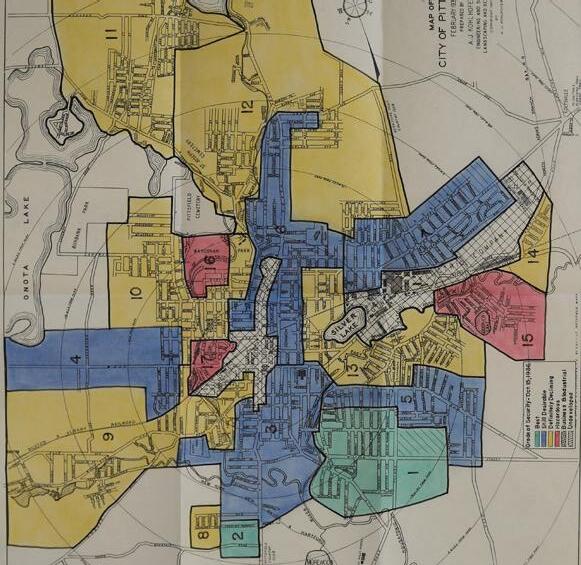
THE EFFECTS OF REDLINING
In the 1930s, as part of the New Deal, a government sponsored loan corporation (HOLC, the Homeowners Loan Corporation) was tasked with lending money for the redevelopment of neighborhoods and analyzing the risk of those federal investments. The term “redlining” describes the use of the color-coded maps to determine how financially hazardous a community was to investment to inform lending practices. The practice of lending and assessing the risks of investment was largely based on race and neighborhoods with Black residents were deemed unworthy of investment. This process has created barriers to homeownership for marginalized groups, intensified economic stratification, and deepened segregation in communities.
Systemic patterns of disinvestment, like redlining and the formal exclusion of Black residents from land leases, have lingering and broad sweeping effects on homeownership levels and community wealth today. Such practices from the past also affect the unequal access to food. West Side and
Source (map and image): Mapping Inequality: Pittsfield, MA
Morningside have been identified as neighborhoods where many residents are still struggling with food access today.
Pittsfield-specific examples of these lasting impacts include:
• “Homeownership rates for Black residents in Pittsfield are 7 percentage points lower than they were in 1950, 13 percentage points higher today for white citizens than they were in 1950.”
• “The average lifespan in the West Side is 9 years less than those in southeast Pittsfield’s more exclusive neighborhoods.”
• “The median income for Black residents in the West Side is less than 40% of the median income in the city”
• “Poverty has quadrupled in the West Side between 2000 and 2018” (Kamaar Taliaferro, Redlining in Pittsfield, Massachusetts: A Case Study).
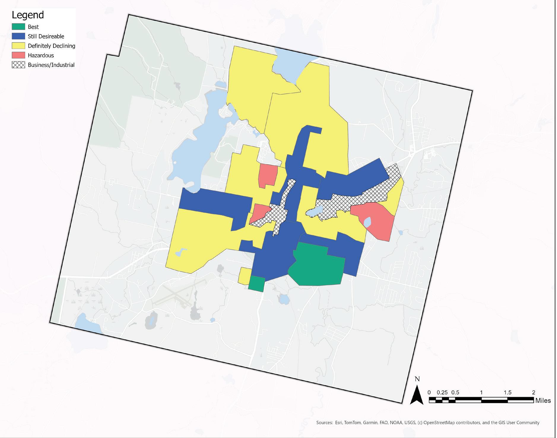
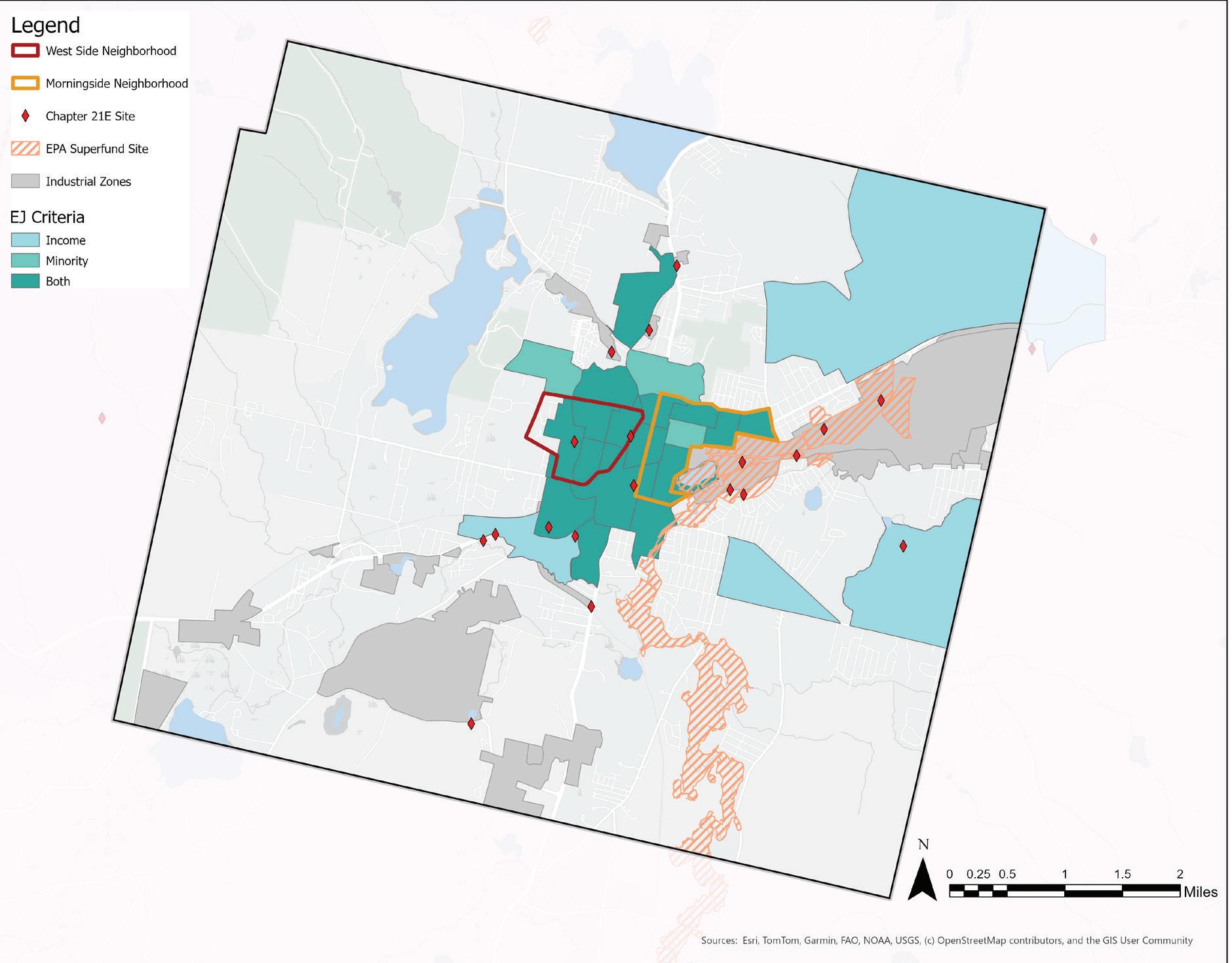
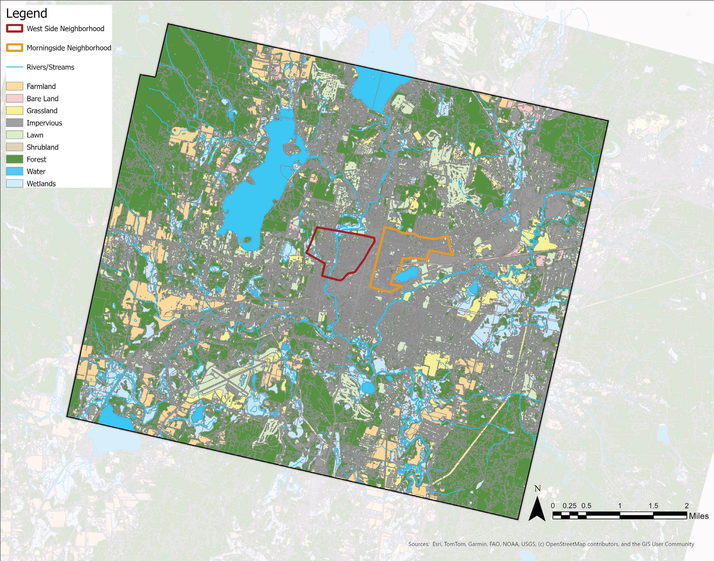
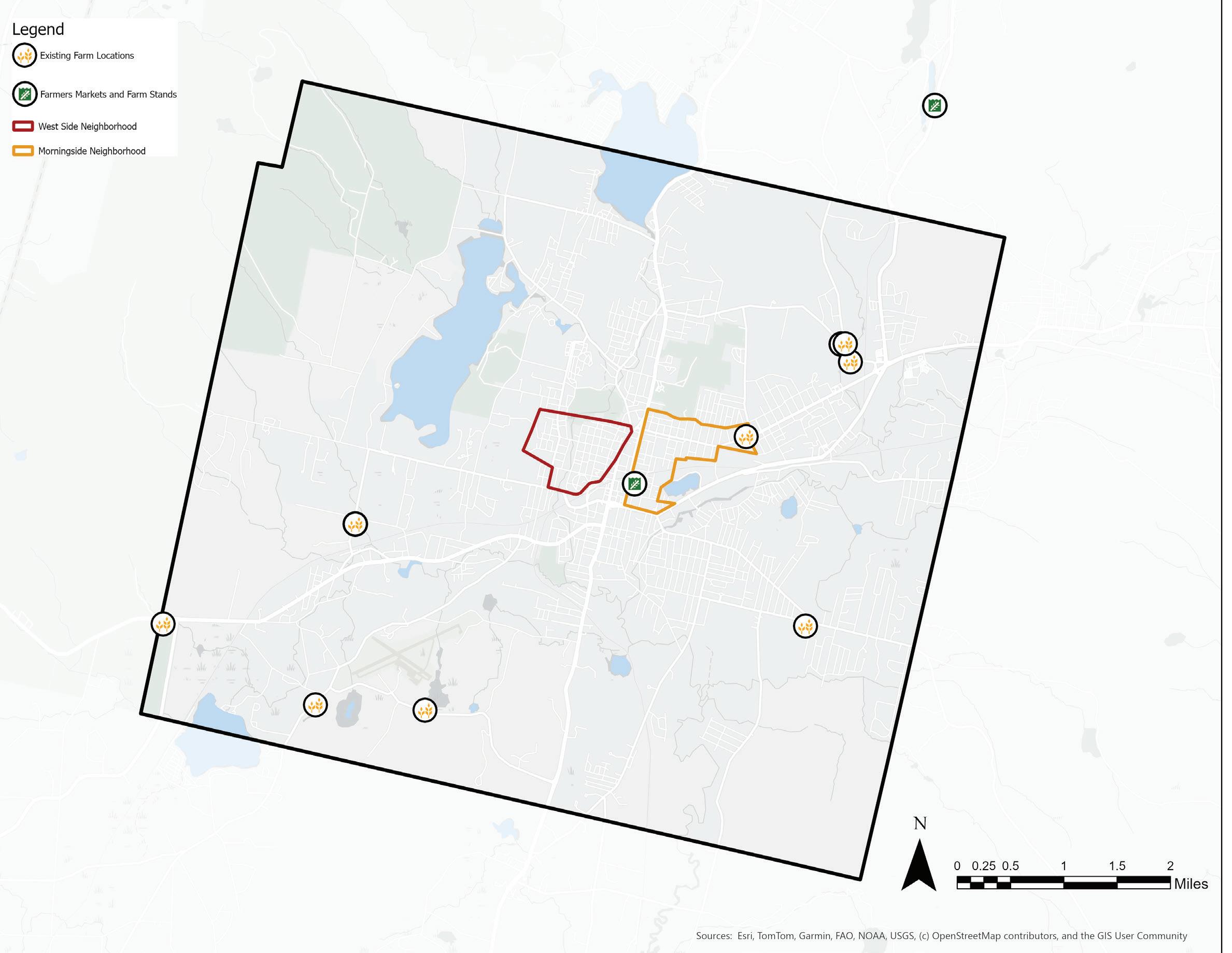
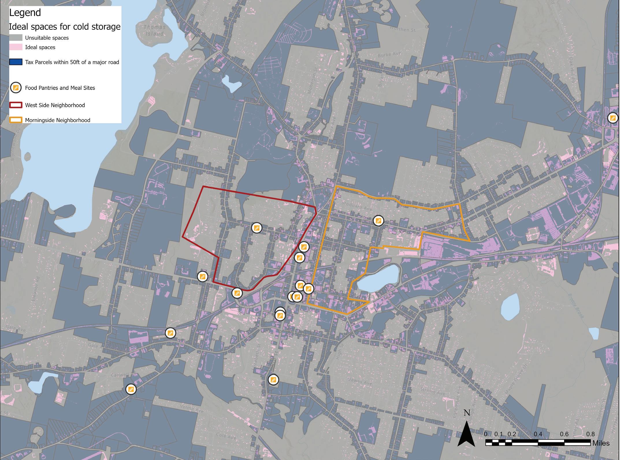
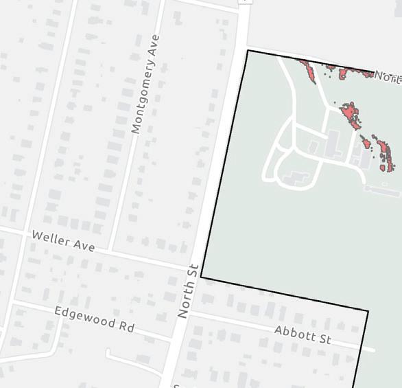
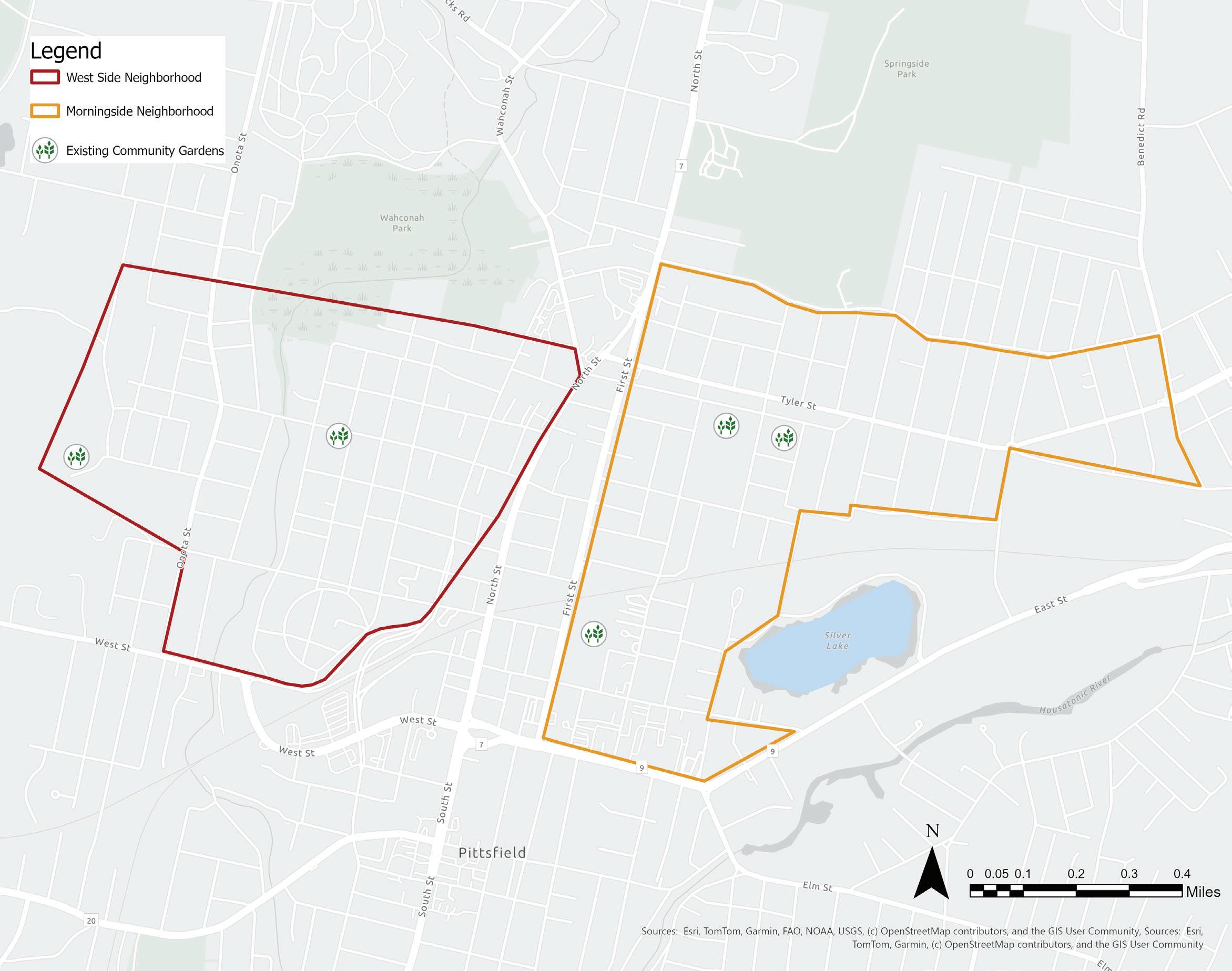
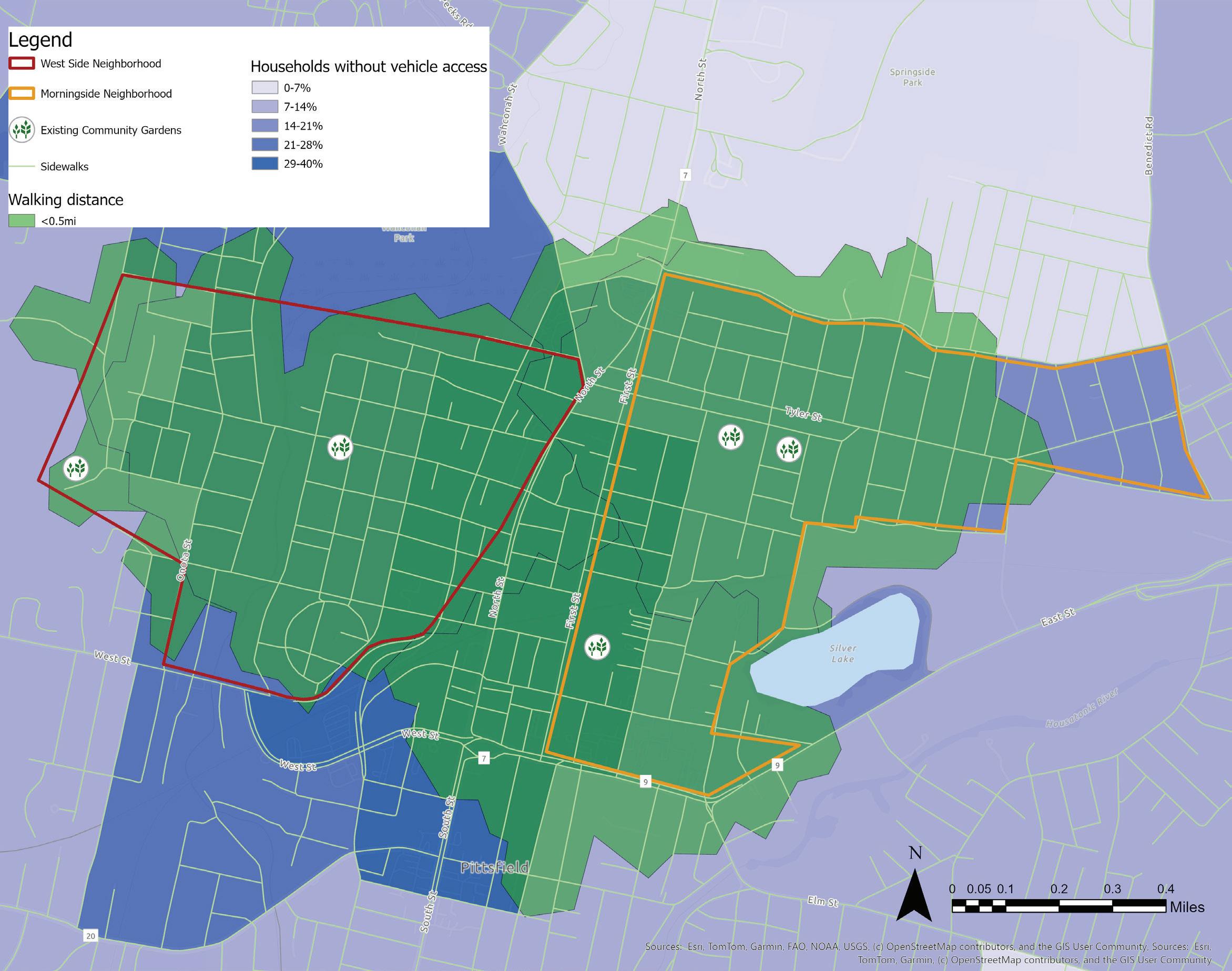
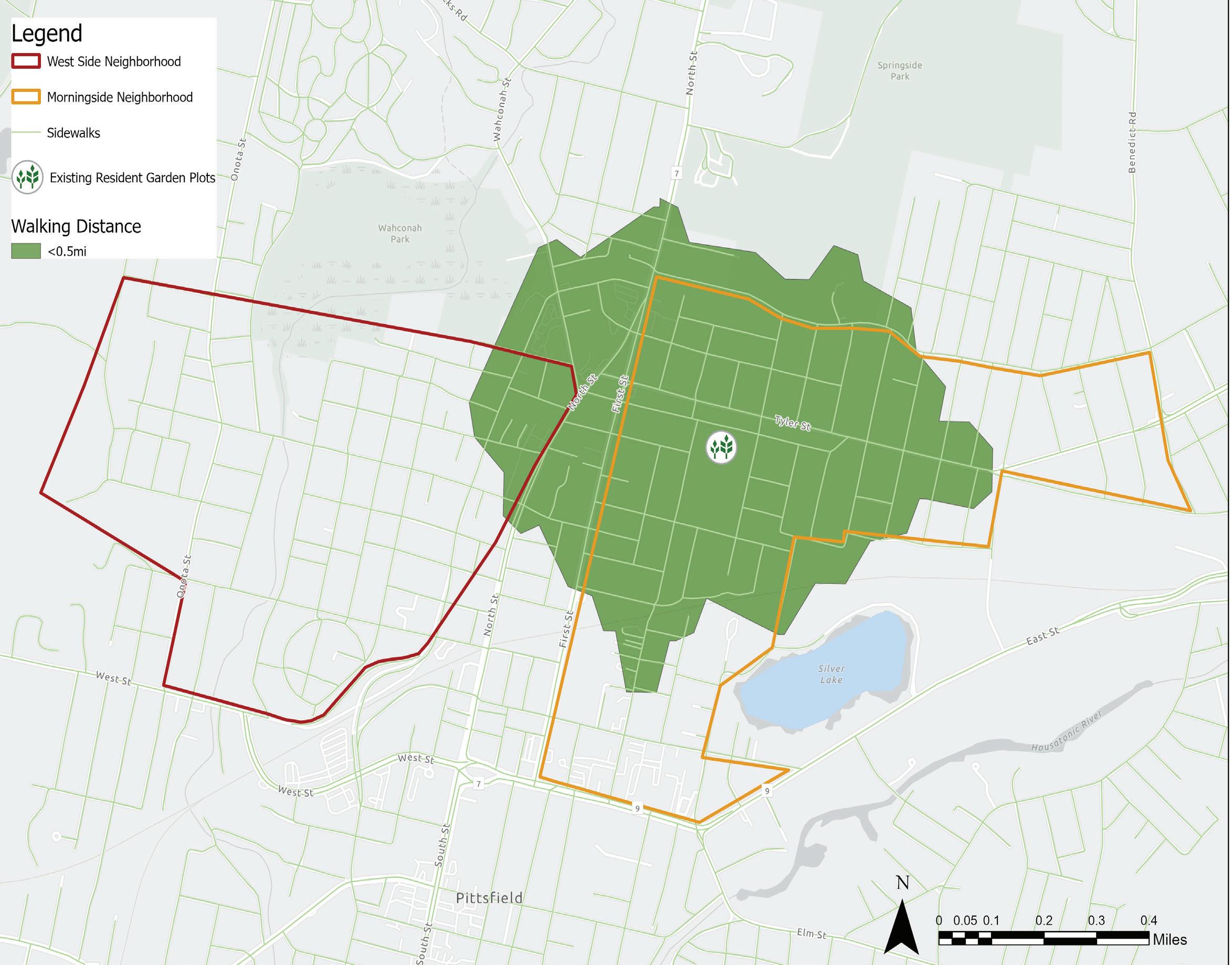
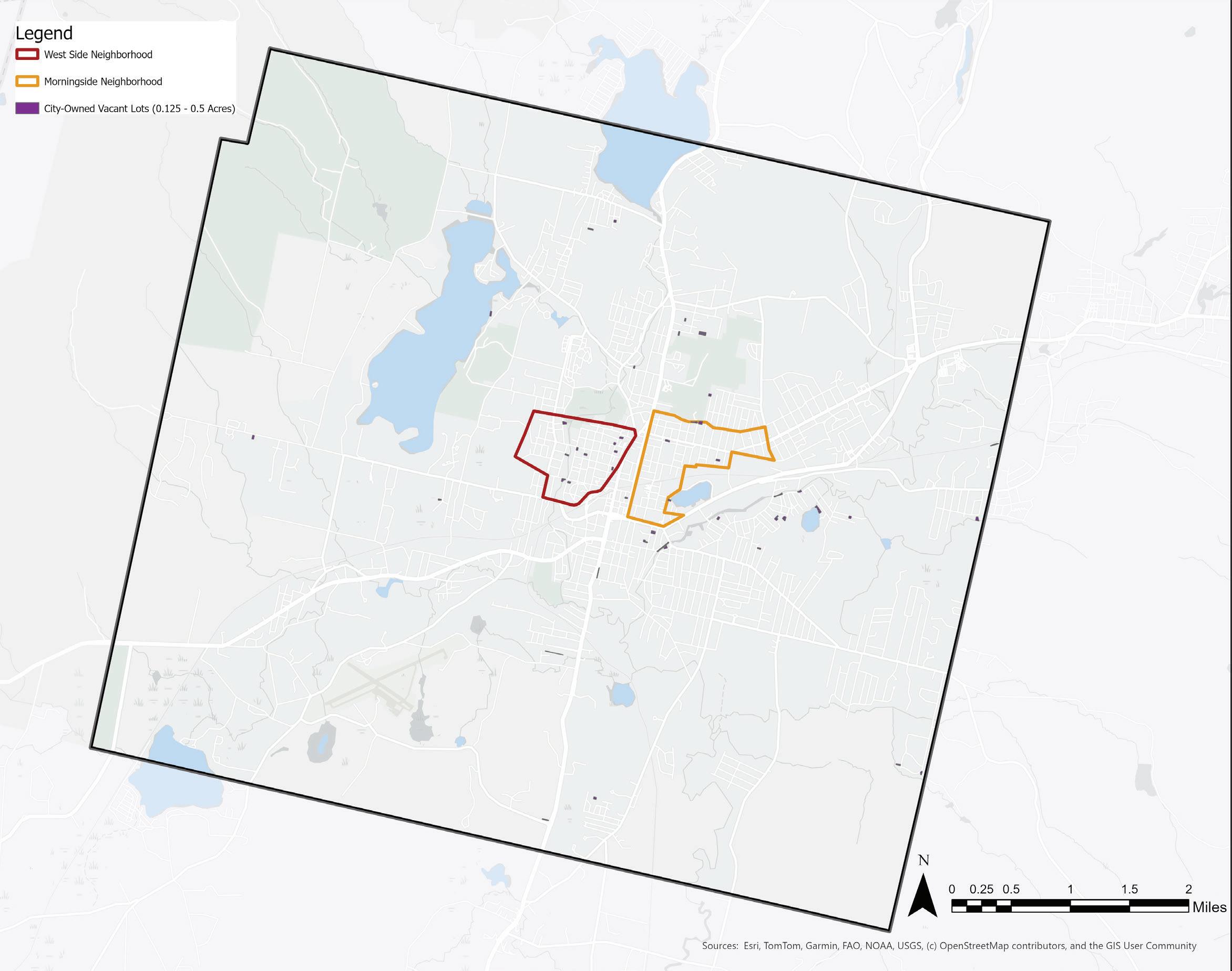
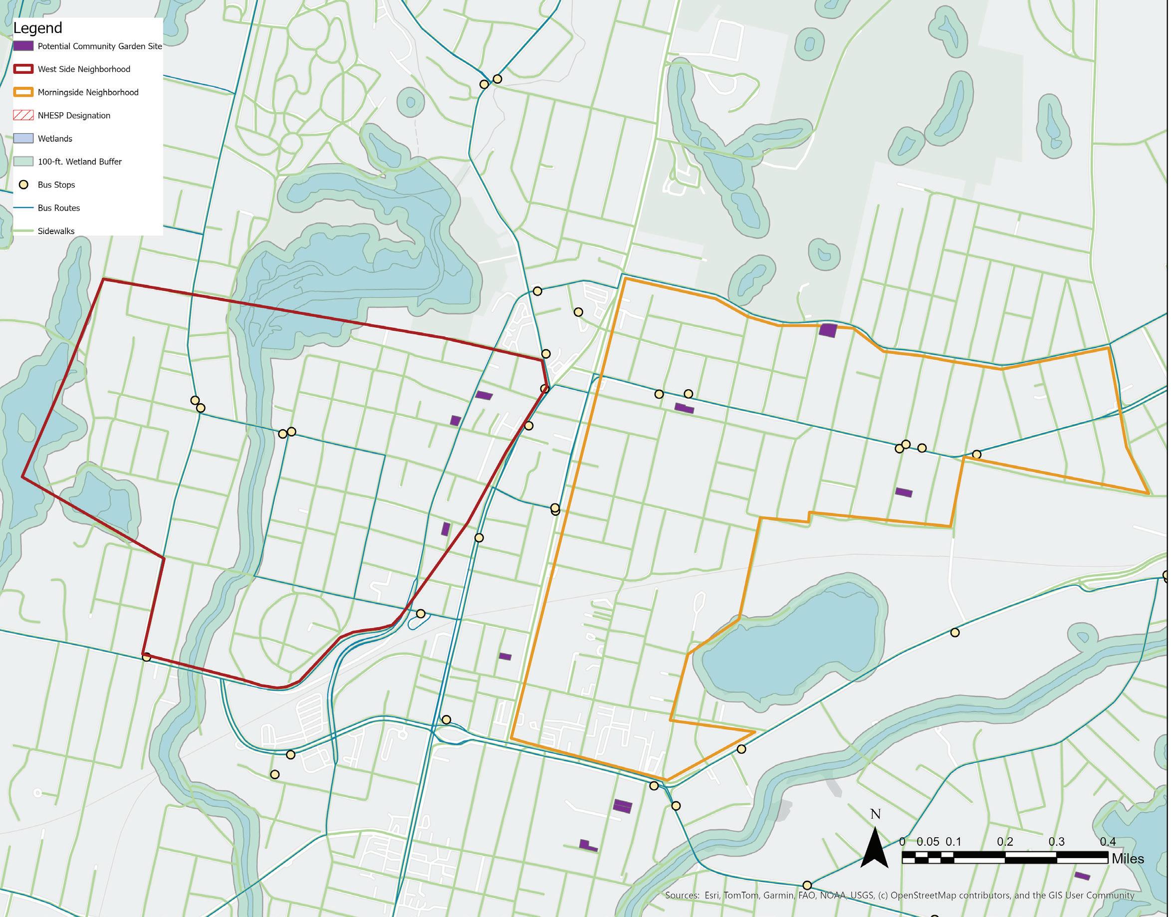
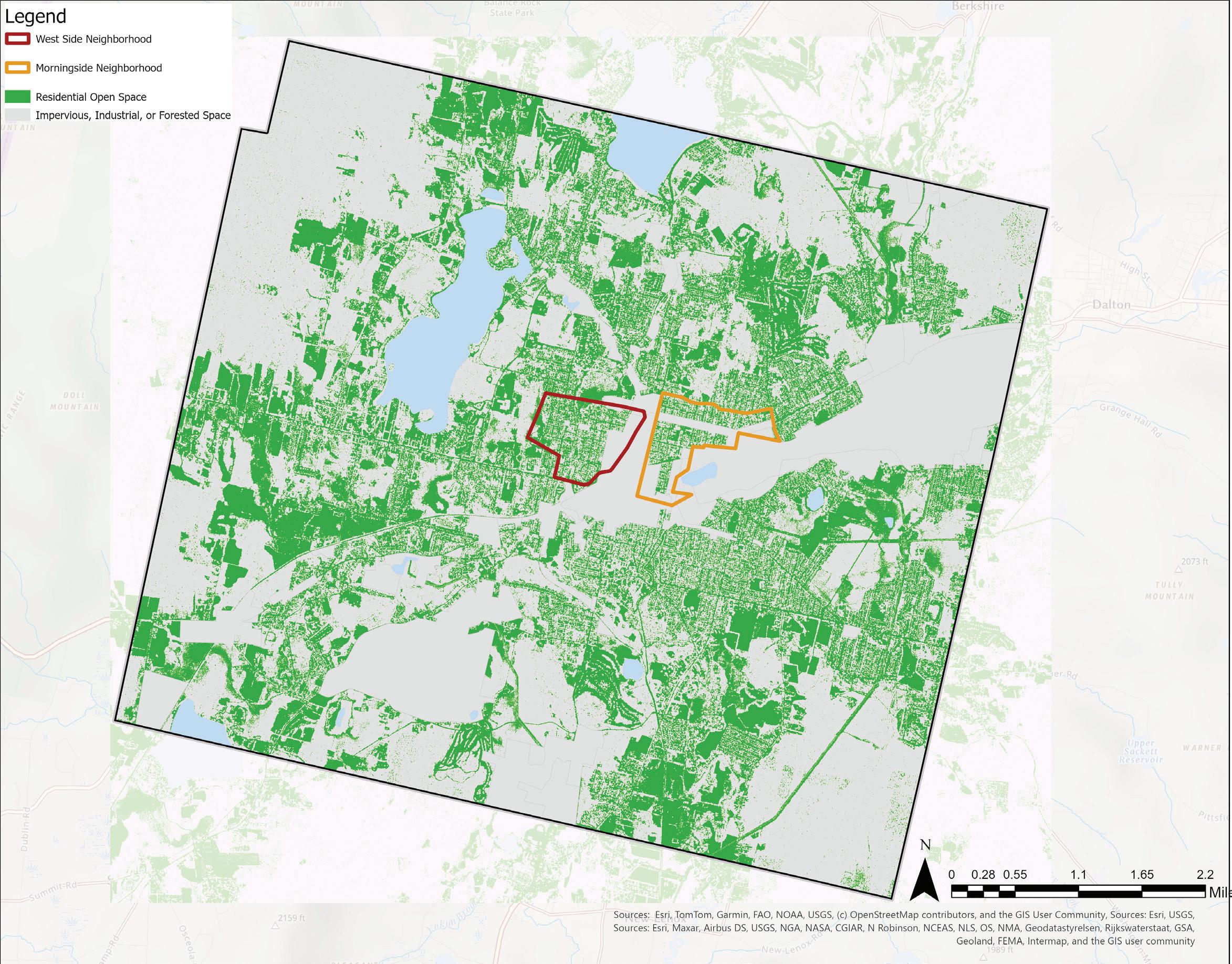
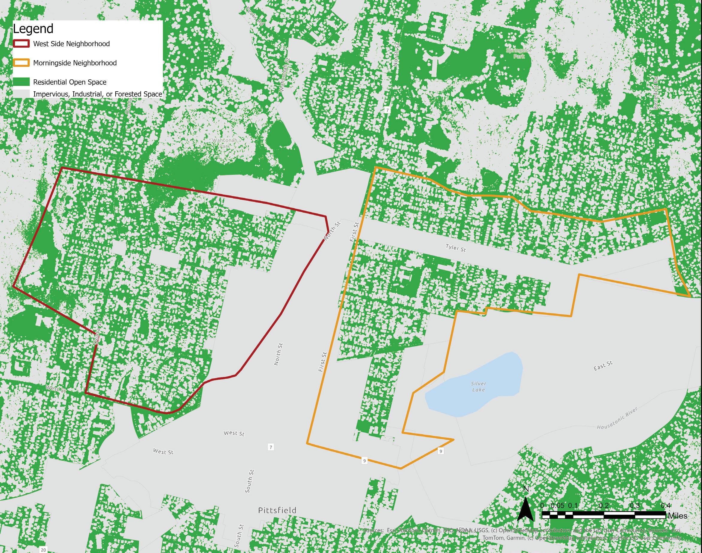
NEIGHBORHOODS OF FOCUS: Westside and Morningside
Many stakeholders interviewed for this project (non-profit workers, community navigators, planners at the city, gardeners, and community member) expressed that West Side (outlined in red) and Morningside (outlined in orange) neighborhoods are experiencing acute food insecurity.
Over the years, health outcomes monitored in these neighborhoods differ greatly from those of the outer census tracts:
“A review of existing health studies conducted by the Grey to Green initiative of [Berkshire Regional Planning Commission] found that average lifespans in the Westside Neighborhood were 9.5 years shorter than those in more affluent sections of the city, such as the SouthEast neighborhood. Notably, this goes against the countervailing common sense that identifies neighborhoods associated with PCB pollution as the worst off, health-wise. The decade-sized gap in lifespan is not entirely
explained by the nationwide trend linking income and lifespan. It can, however, be explained by segregation” (Kamaar Taliaferro, Redlining in Pittsfield, Massachusetts: A Case Study).
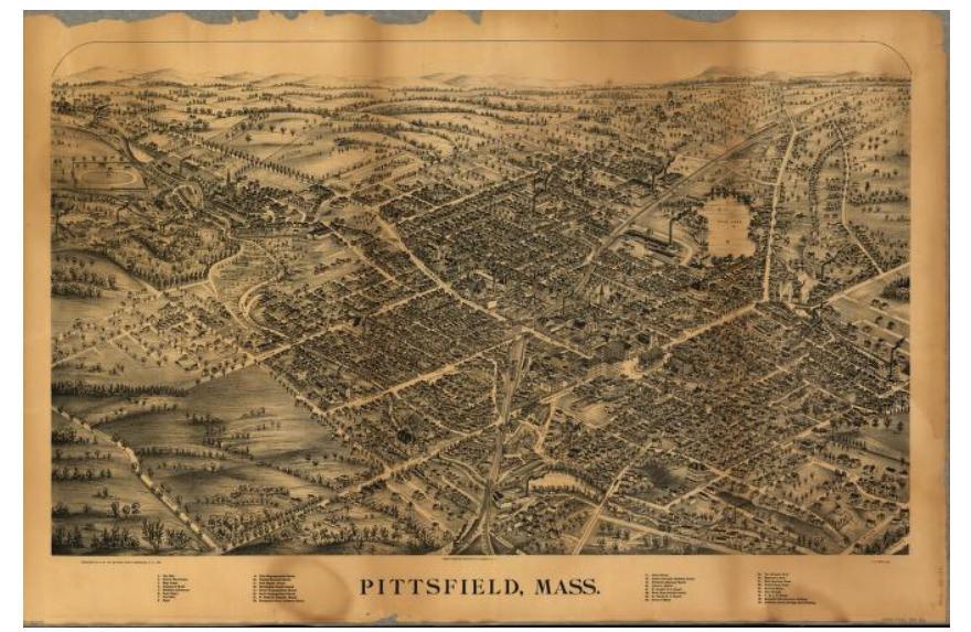
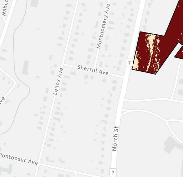
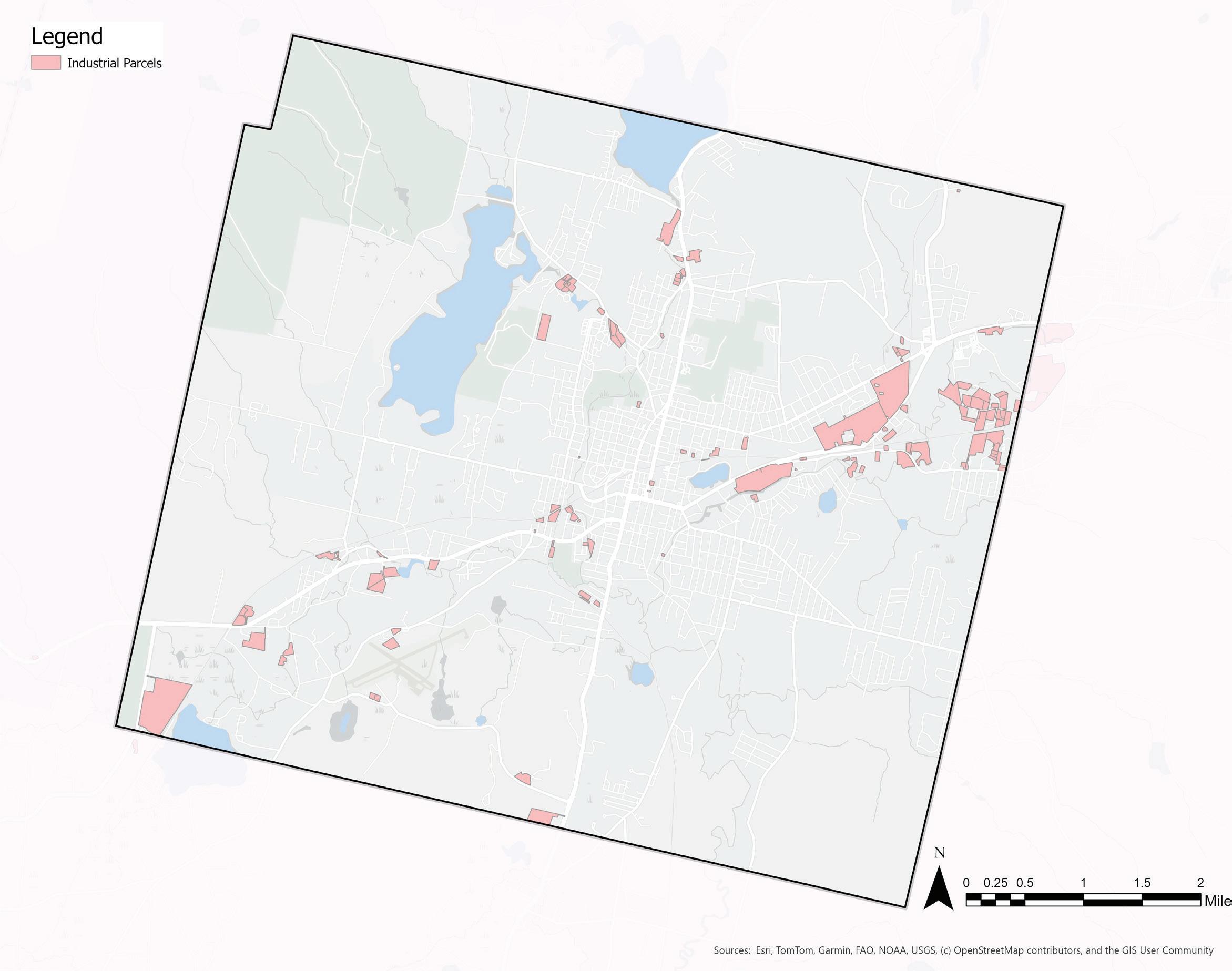
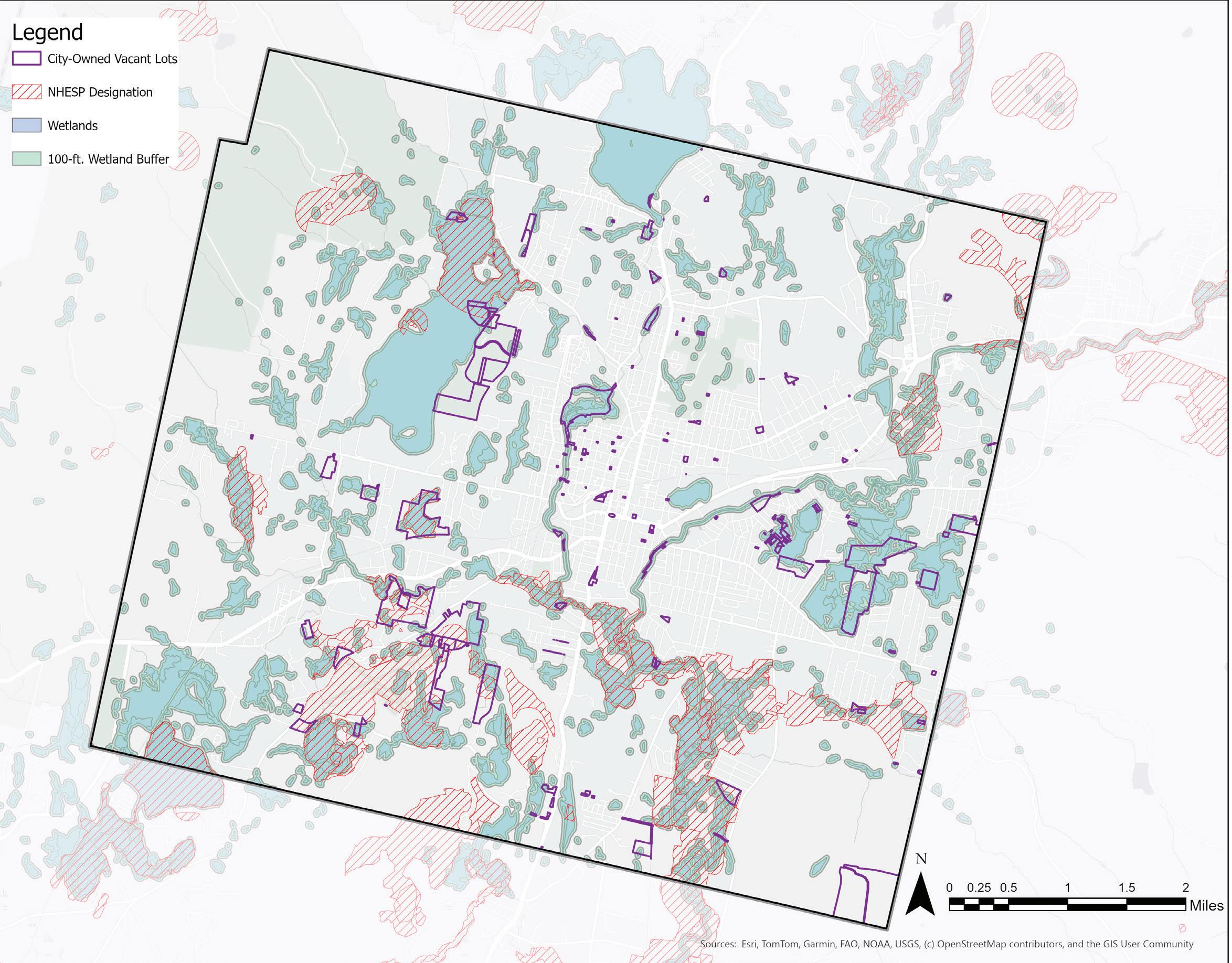
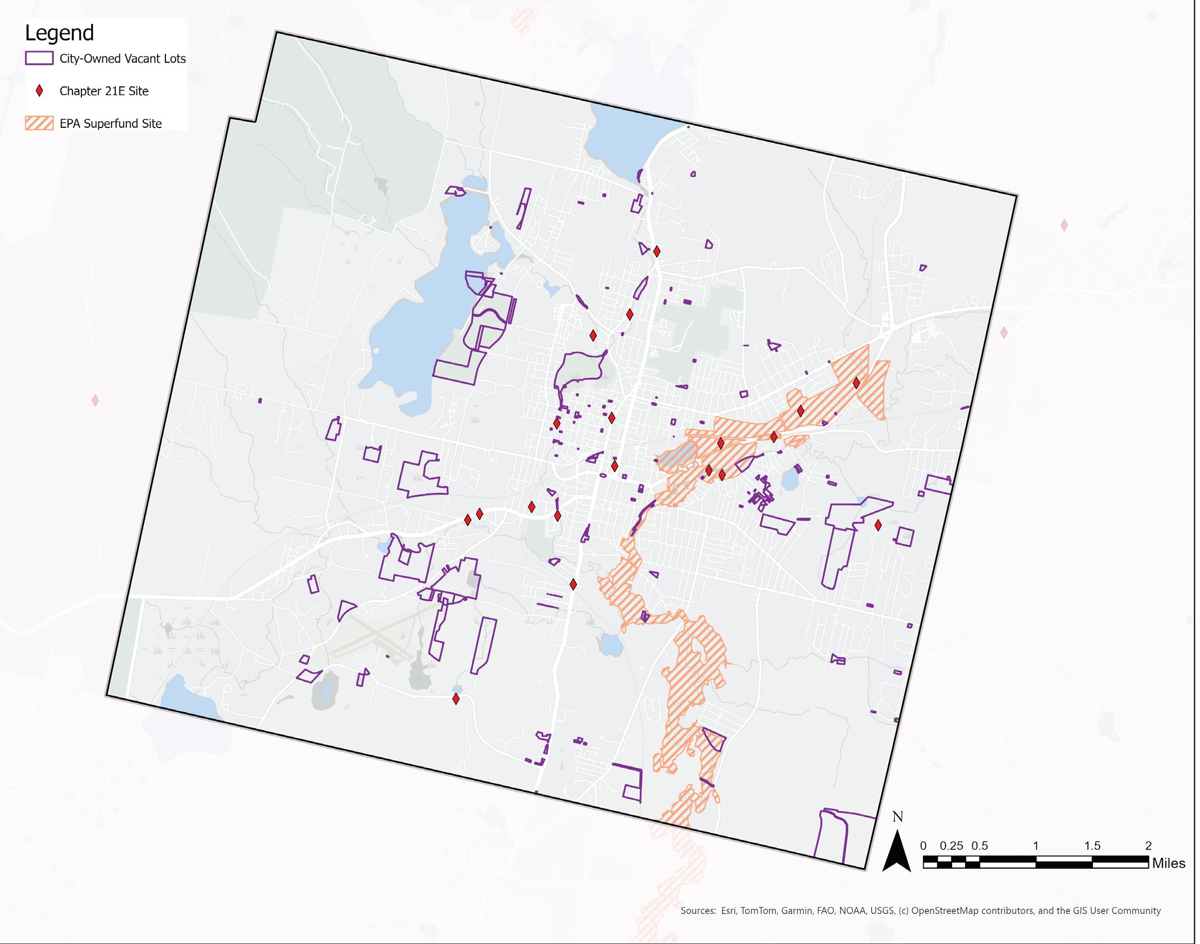
A map of environmental justice (EJ) communities highlights that concentrations of low-income and minority populations living in West Side and Morningside. It also displays the proximity of these neighborhoods to Chapter 21E sites, where oil or hazardous chemicals have been identified, and EPA superfund sites, designated for federal remediation or cleanup. All Chapter 21E sites in Pittsfield lie within environmental justice neighborhoods or industrial zones, while the Morningside neighborhood is directly adjacent to the Housatonic River cleanup site that was polluted for decades by GE. Proximity to these hazardous sites poses risks to human health, deters investment in these communities, and creates barriers to food production due to contaminated water and soils.
GATEWAY CITY STATUS
In 2007, Pittsfield was named one of the eleven original Massachusetts Gateway Cities, a unique label for mid-size urban centers of regional economic importance with large populations of people of color. Gateway Cities have historically been destination cities for foreign-born immigrants to the Commonwealth, providing jobs and a “gateway” to a new life in the United States. Today, there are twenty-six Gateway Cities which “are home to 27% of Massachusetts residents and nearly 40% of [the] state’s foreign-born population. Collectively, [the Gateway Cities] are majorityminority since 2020 (MassINC).” These communities have a myriad of assets, serving as cultural and resource hubs in their respective regions and are home to schools, community centers, hospitals, walkable downtown centers, and additional services utilized by their surrounding areas. Despite these assets, many Gateway Cities are post-industrial communities that face elevated economic and social constraints, including wealth disparities, decreasing populations, and aging infrastructure. Gateway Cities are eligible for special grants intended to support community development in
areas such as housing, education, parks and recreation, and more, to repair economic disparities caused by decades of discriminatory policies and disinvestment in communities of color.
Pittsfield’s complex history as a post-industrial urban center with a growing minority population and a history of racial discrimination poses questions about how a city can construct a food system adapted to ever-shifting economic and social dynamics.
Source: MassGIS
Pittsfield
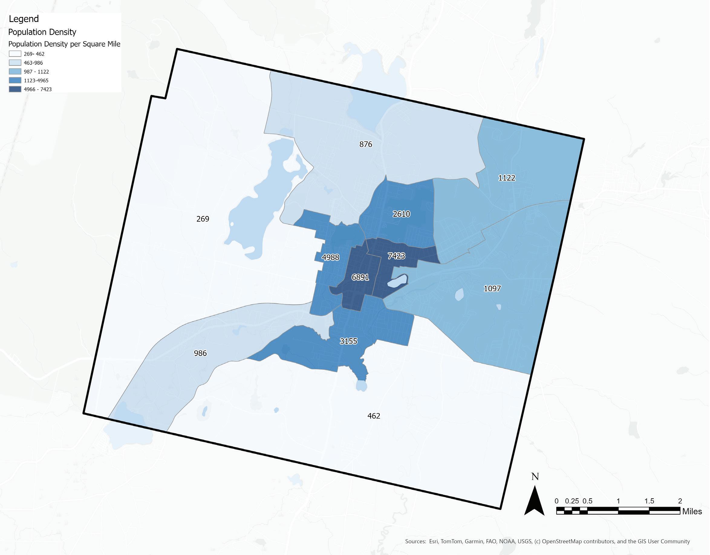
DEMOGRAPHICS | Population Density
Maps displaying the demographic data collected by the American Community Survey describe current economic and demographic conditions in Pittsfield. Many of these factors are explored in relation to food access in Section 5.
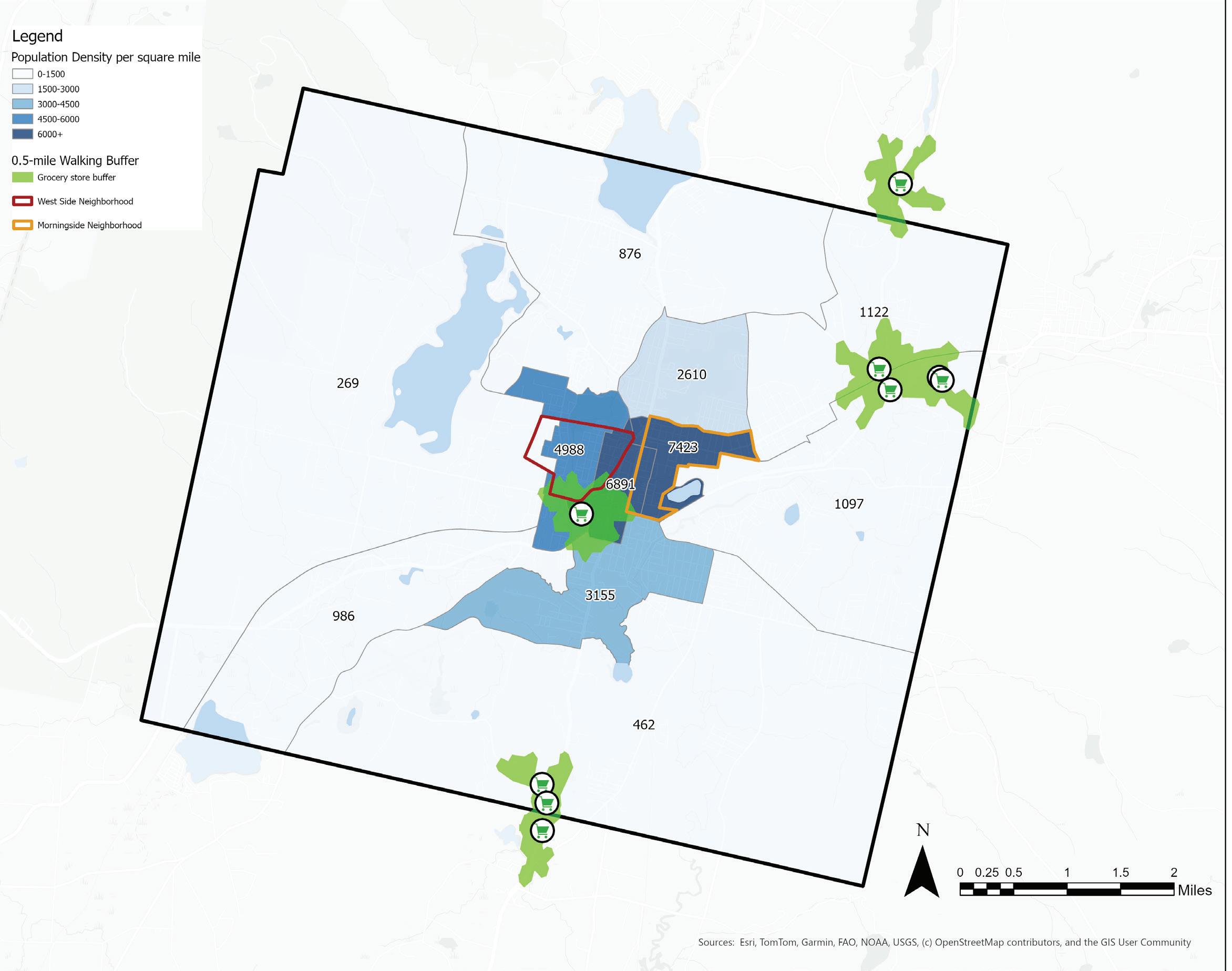
The above map displays Pittsfield’s population density. The census tracts located in the center of the city have the highest population densities of about 7,400 residents per square mile. The outer census tracts are significantly less populated at about 269 residents per square mile.
Source:
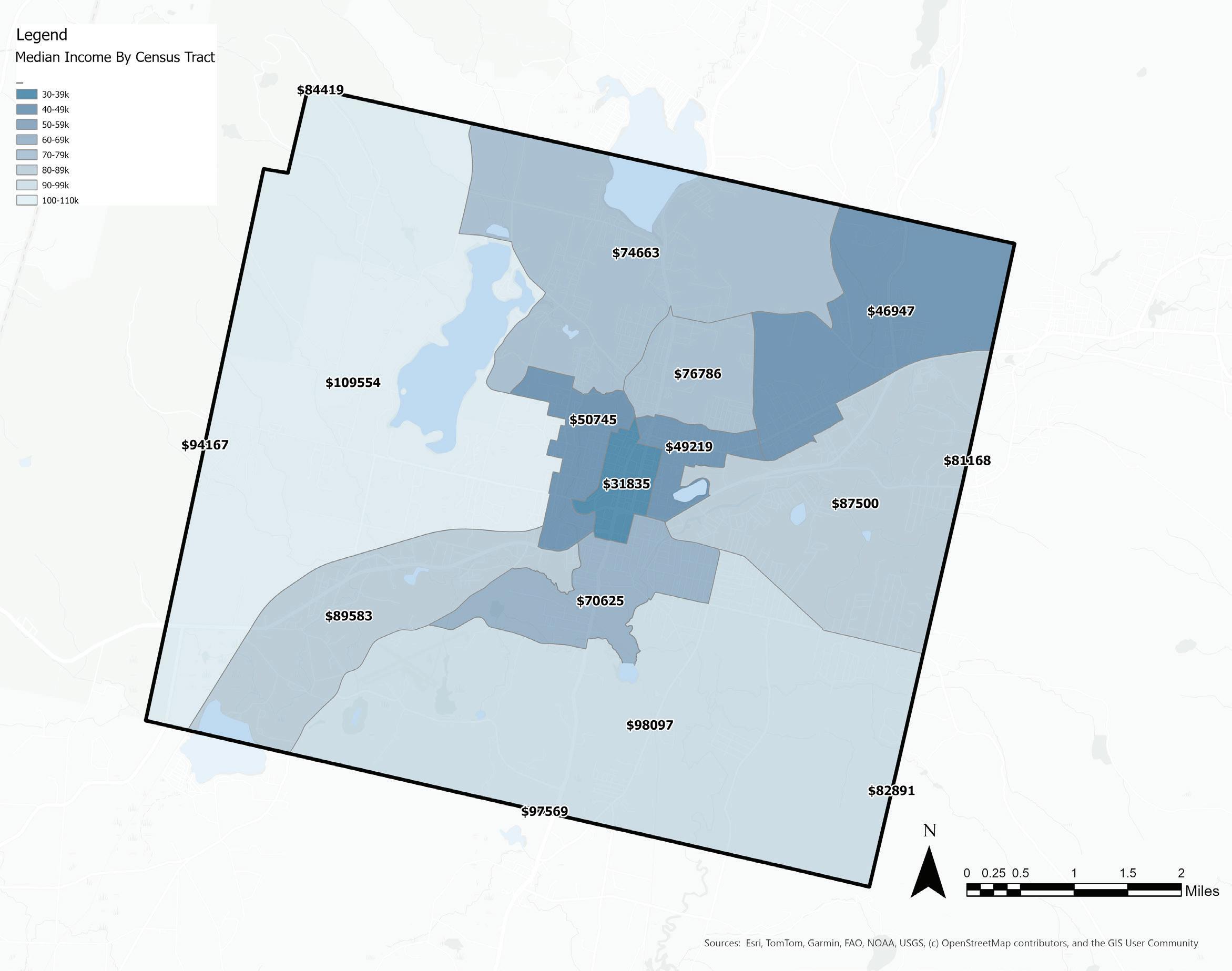
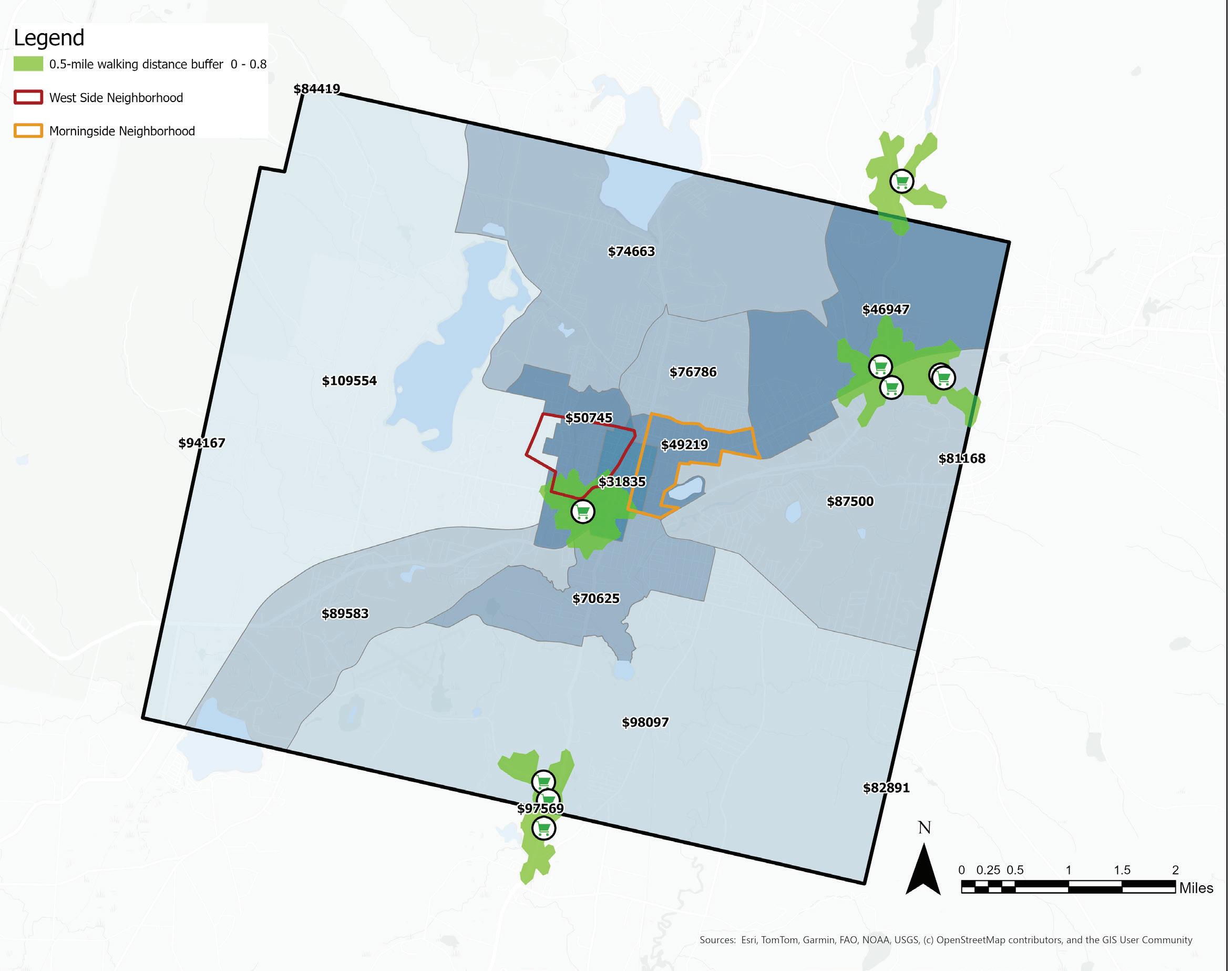
DEMOGRAPHICS | Median Household Income
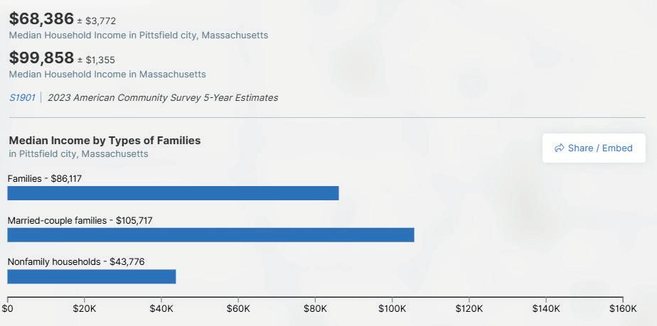
The median income in Pittsfield as a whole is around $68,000 per household per year. However, residents living in the downtown area of Pittsfield make a median income between $30,000-$50,000 per household, whereas median household incomes in the surrounding tracts are over twice the amount per year, between $70,000 and $110,000. Spatially, this reveals the households that would be most affected by rising food costs and cuts to food assistance programs.
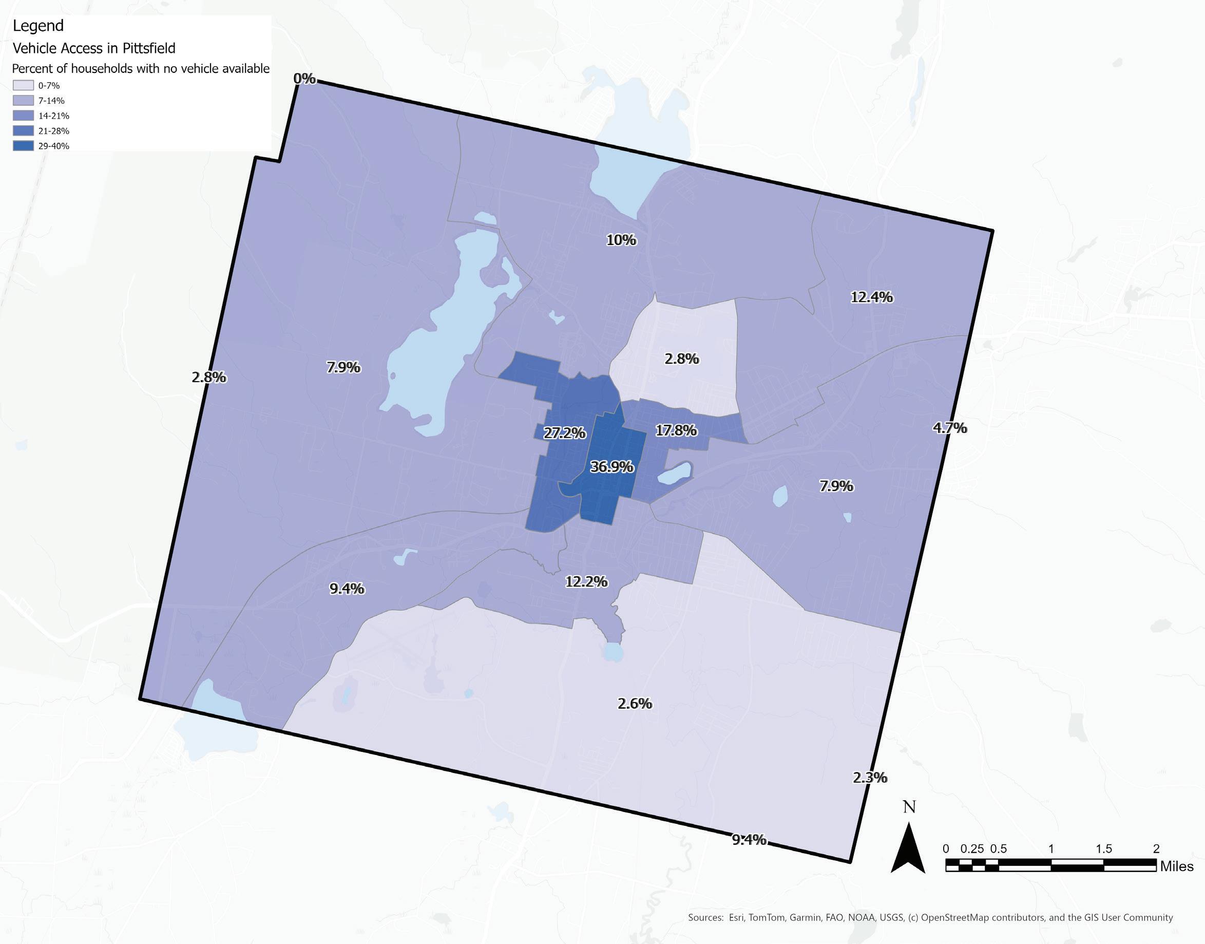
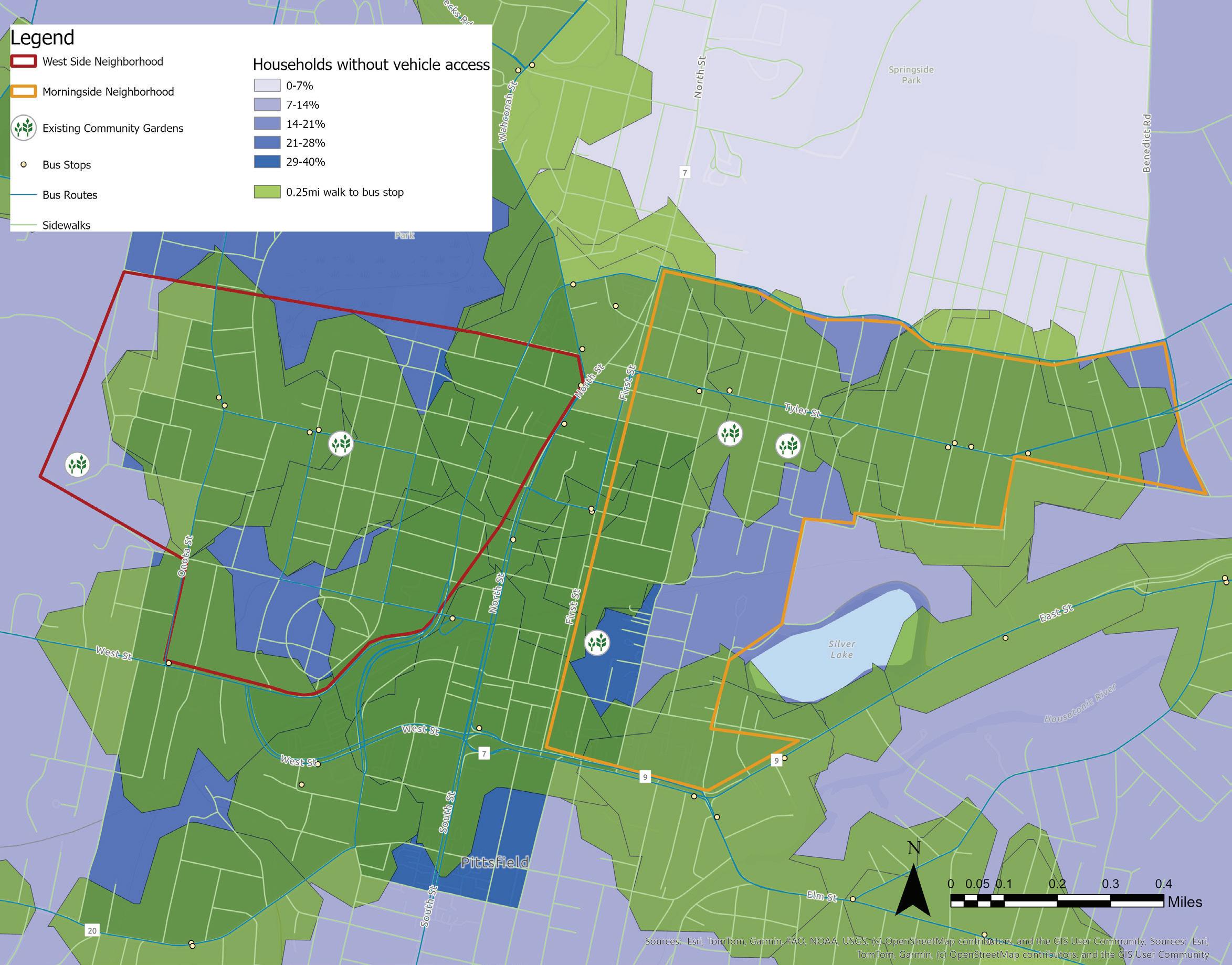
DEMOGRAPHICS | Household Vehicle Access
This map shows us that close to 40% of the households in the census tracts downtown do not have access to a personal vehicle, while most households in the surrounding tracts have access to a vehicle. This map reveals households that may have physical barriers to accessing food, especially if food is not locally available in the winter.
Source: ACS Household vehicle access by census tracts
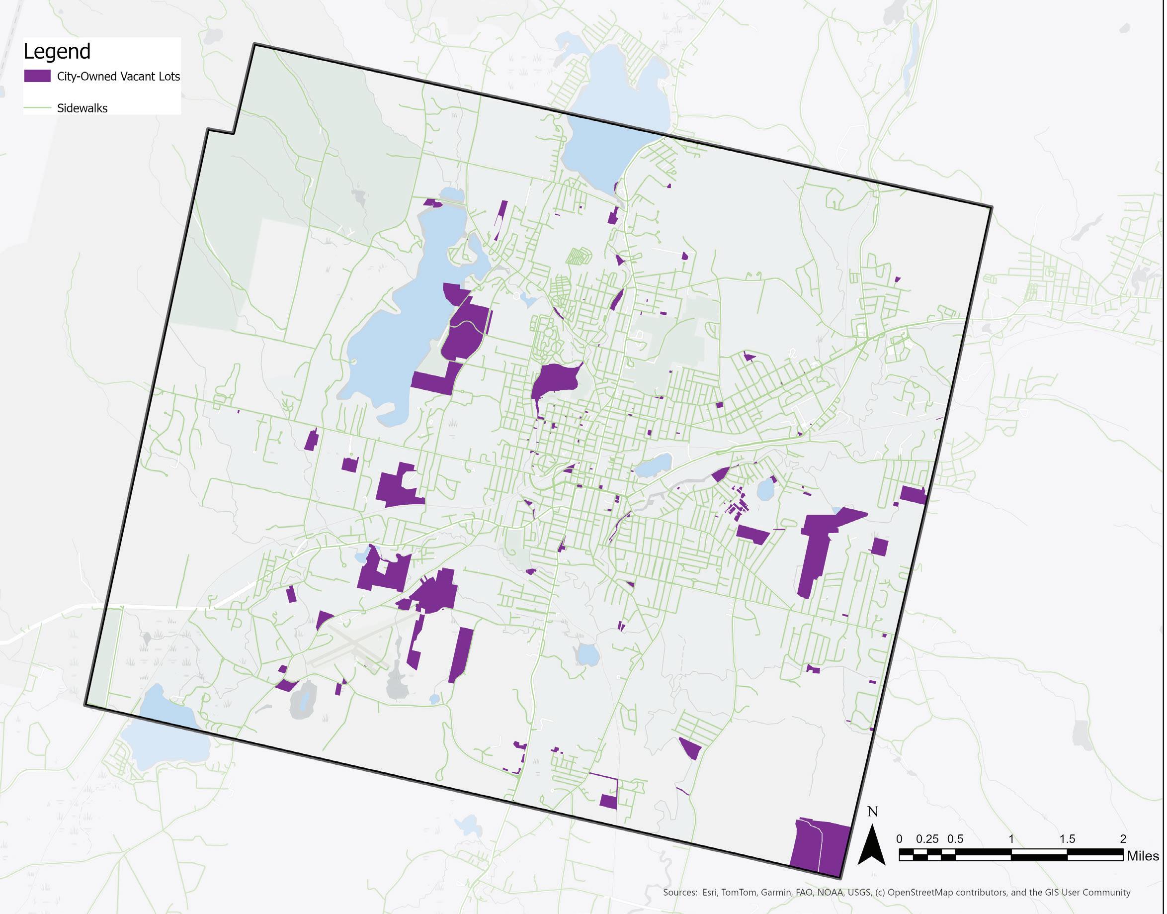
LAND USE
Pittsfield is the largest urban center of the Berkshire region, and is heavily developed in its downtown and eastern zones with high concentrations of impervious surfaces. Despite this, Pittsfield has an array of natural beauty that adds to its urban charm and links the city to the surrounding bounty of the Berkshires. A network of waterways is anchored by the Housatonic River, the headwaters of which are just miles away in the Berkshire Mountains. Lakes and wetlands dot the cityscape and blur the built and natural environments. Pockets of forest can be found throughout Pittsfield, but dominate the northwest corner of the city and connect to a north-south swath of intact forest.
The West Side and Morningside neighborhoods in downtown Pittsfield are some of the most impervious areas in the city with minimal access to green spaces that are located farther outside the city center. This presents another equity issue at play in many urban environments, contributing to higher rates of stress, mental health disorders, and cardiovascular conditions in residents lacking access to green spaces (Nguyen 2021). Green spaces in urban centers have additional benefits, improving air and soil quality and providing habitat for wildlife (Zhang 2024).
Housatonic River
ECOLOGY
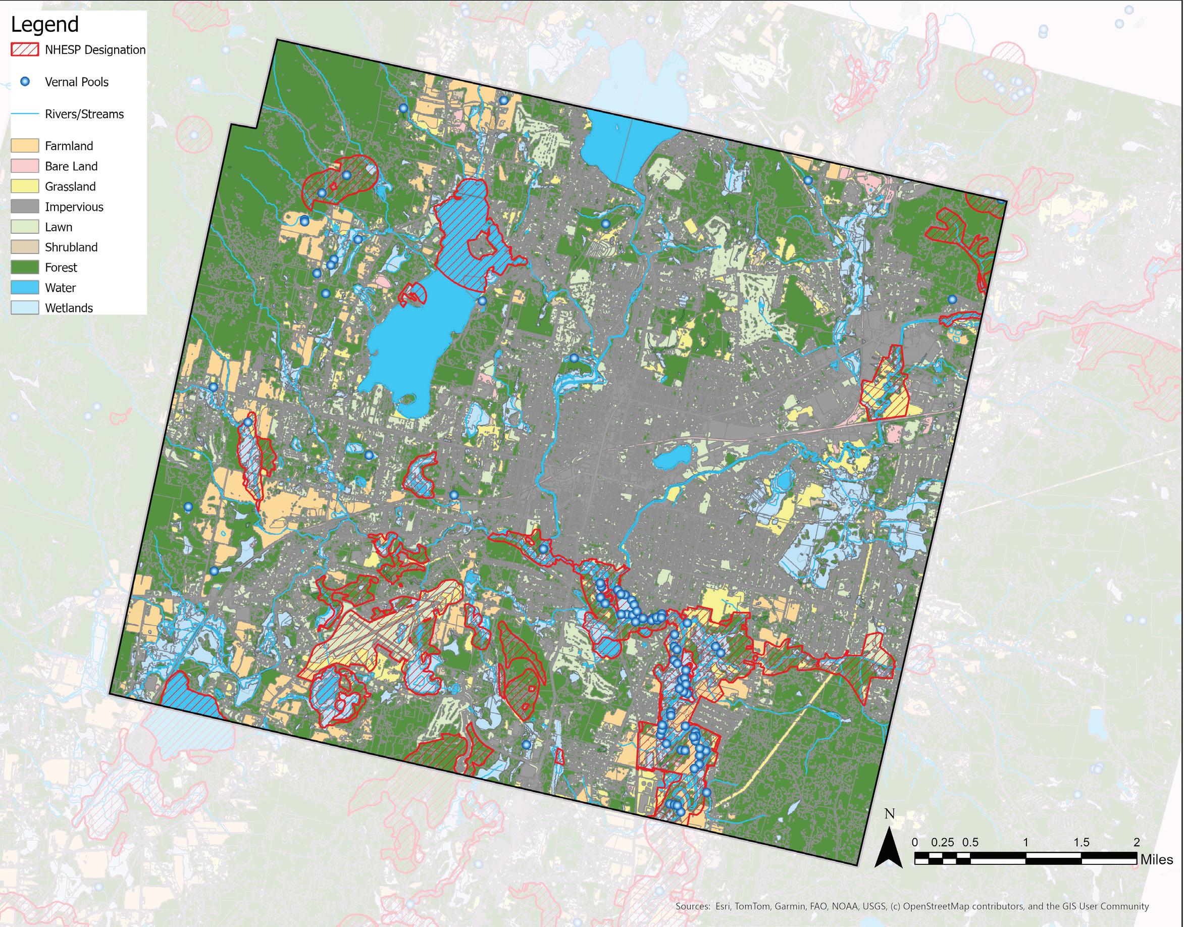
Despite its impervious urban center, Pittsfield’s landscape remains ecologically dynamic and important for numerous wildlife species.
MassWildlife’s Natural Heritage and Endangered Species Program (NHESP) designates areas of unique ecological importance to rare or priority species or natural communities, and can be found in the pockets of forest, vernal pools, wetlands, and waterways in Pittsfield. There are several areas of farmland designated as NHESP zones, as well as grasslands, which serve as unique and biodiverse ecosystems in urban landscapes and provide important habitat.
Even heavily developed and impervious areas, like Pittsfield’s city center, interact with the local
ecology. The east and west branches of the Housatonic River flow through downtown and meet in southern Pittsfield, travelling through Connecticut before entering the Long Island Sound. While this has posed challenges in the form of industrial pollution upstream of NHESP areas, posing health risks to humans and wildlife alike, it also provides residents of Pittsfield’s urban neighborhoods with access to water and riverfront parks in an otherwise impervious environment. These waterways and green spaces, along with urban tree cover and community and residential gardens, serve as important habitat for wildlife in densely-populated human spaces.
Housatonic River
Sources:
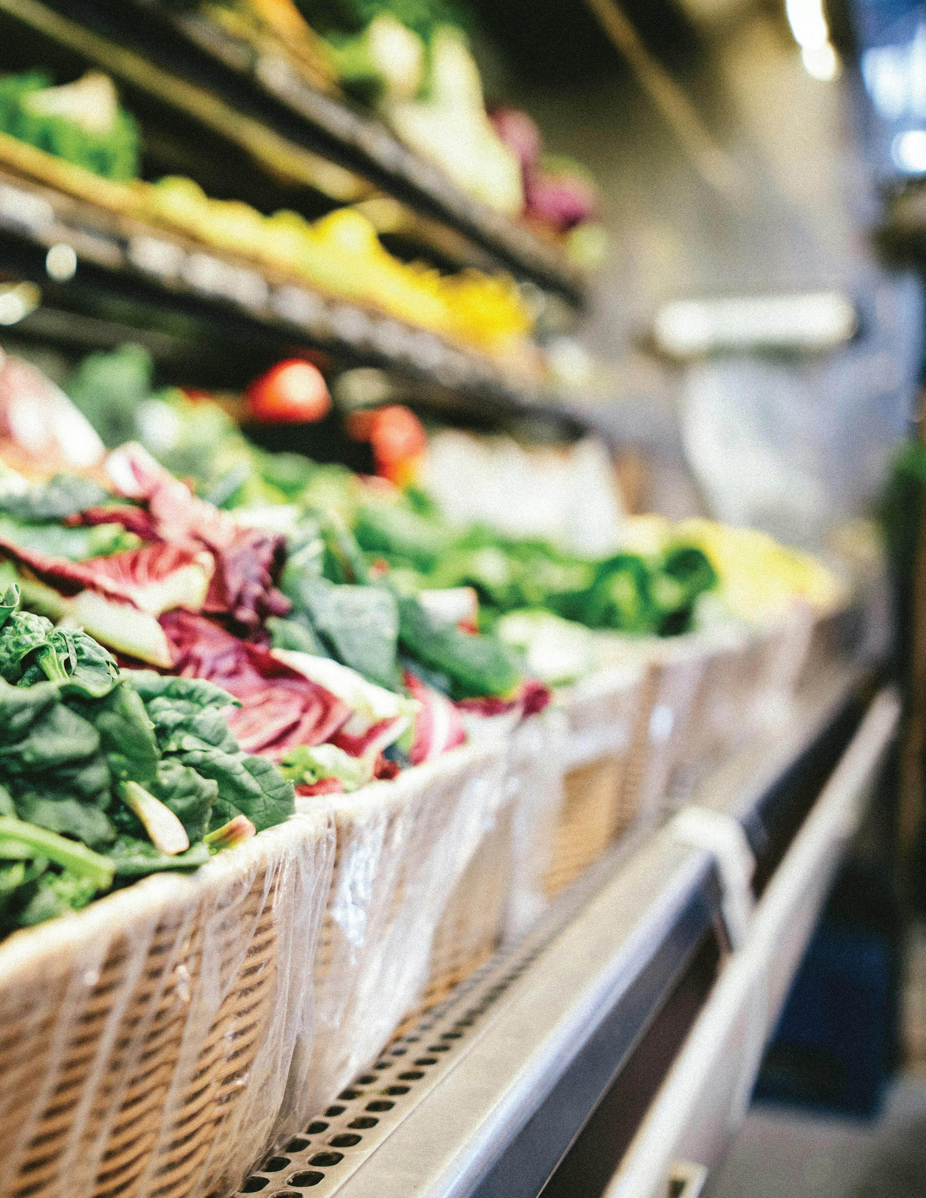
FOOD ACCESS
GROCERY STORES
SUPERMARKETS
SPECIALTY STORES
RESTAURANTS
CSAs
FARM STANDS
CORNER STORES
Where do people access food in Pittsfield?
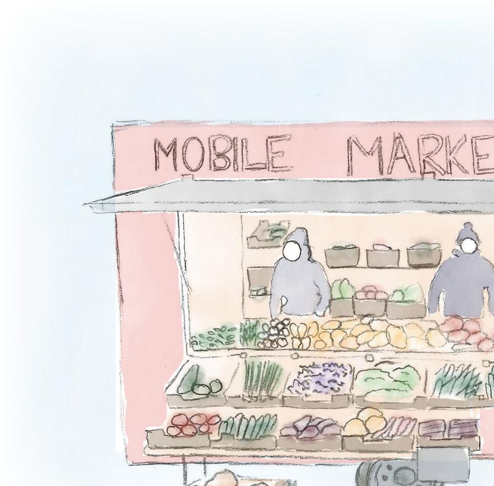
MOBILE MARKETS
MEAL SITES
HOSPITALS
PANTRIES
FARMER’S MARKETS
DELIVERY PROGRAMS
SCHOOLS
FOOD ACCESS
In Pittsfield, food is accessed at a number of different locations. Grocery stores, convenience stores, restaurants, pantries, meal sites, delivery programs, and schools are some of the main points of food access for the community. One key difference between these locations is that some locations charge for food while others do not. These points of access also vary in where they are located, when they operate and the availability or amounts of fresh, local food being offered. Listed below are some of the policies and programs that support the access to food for many of Pittsfield’s residents.
SUPPLEMENTAL NUTRITION ASSISTANCE PROGRAM (SNAP)
The SNAP program (formerly known as food stamps) provides funds for residents to buy food if they are eligible based on criteria like income levels, number of residents in the household. The funds are not restricted to food that is fresh or locally produced and is often usable at a wide range of stores, from gas stations to supermarkets (DTA, “SNAP Benefits”).
HEALTHY INCENTIVES PROGRAM (HIP)
Launched in April 2017, the Massachusetts Healthy Incentives Program (HIP) used to provide monthly incentives to SNAP households of up to: $40 to $80 for eligible residents, when they purchase fresh, local, healthy vegetables and fruits from farmers at farmers markets, farm stands, community supported agriculture (CSA) farm share programs and mobile markets. The program is administered by the Department of Transitional Assistance, in partnership with the Department of Agricultural Resources and the Department of Public Health, and is supported by a grant from the USDA, state financing and private donations. HIP vendors can be found at most farmers markets throughout Berkshire County. The program has increased farmers’ SNAP sales as well as fruit and vegetable intake in participating families. As of February, 2025 across the state of Massachusetts, 63% of the participants were above the age of 60, 18% were
below the age of 18 and 37% reported having disabilities, indicating the importance of the program to vulnerable members of the community (DTA, “HIP Monthly Updates February 2025”).
Recently, as of December 2024, the HIP budget has been cut and residents are now allocated a flat $20 benefit regardless of the size of the household (Mass.gov, “HIP Benefit Change.”).
THE WOMEN, INFANTS AND CHILDREN NUTRITION PROGRAM (WIC)
Similar to SNAP and HIP benefits, this program provides incentives for healthy food and nutritional education to mothers and children below the age of five. Alongside the HIP cuts, cuts to the WIC program is also affecting the purchasing power of residents in Pittsfield (Kaufman).
MARKET MATCH PROGRAM
In 2022, Berkshire Agricultural Ventures established a Market Match Fund that would offer residents a $1 for $1 SNAP match up to $30 at partner farmers markets, including the Pittsfield Farmers Market (Berkshire Ag. Ventures, “Market Match Fund”).
While many of these programs are vital assets to food access in the city, recent cuts to funding have acutely reduced the purchasing power of many vulnerable residents in Pittsfield. The focus of this section has been guided by interviews with shoppers at the Pittsfield Farmers Market and various stakeholders working in the food system who have highlighted some of the current barriers to accessing food in Pittsfield. These barriers include access to personal vehicles or reliable public transportation, walkability to retail locations, the lack of emergency food storage options and the rising cost of food.
The following section inventories food access locations, analyses of some barriers mentioned above and shares recommendations for improving residents’ access to food.
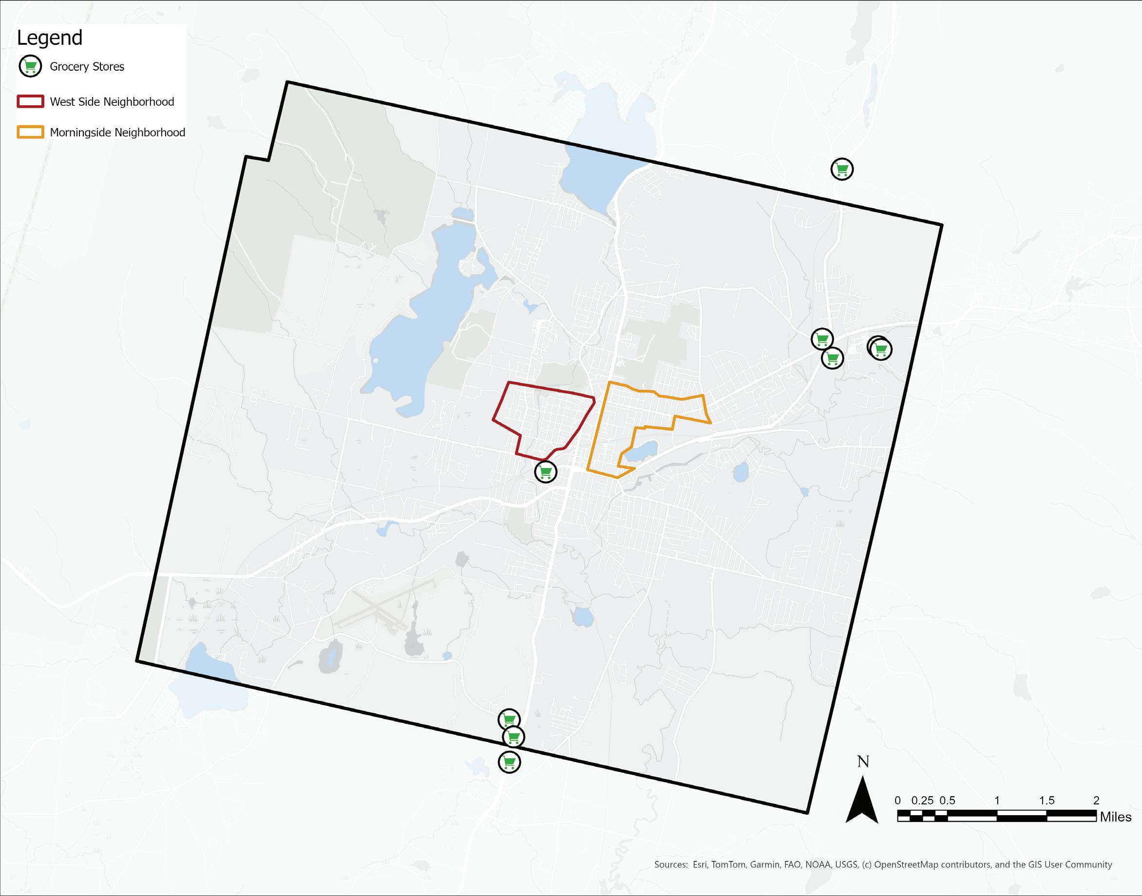
Retail Locations | Grocery Stores
Included in this map are grocery stores that provide access to fresh produce year round (e.g., large chains like Walmart, Big Y, and ALDI and local grocers like Guido’s). These stores accept SNAP dollars. There is a pattern of clustering in the northeast (4 stores) and south (3 stores) and only one storefront in the downtown area of Pittsfield.
Source:
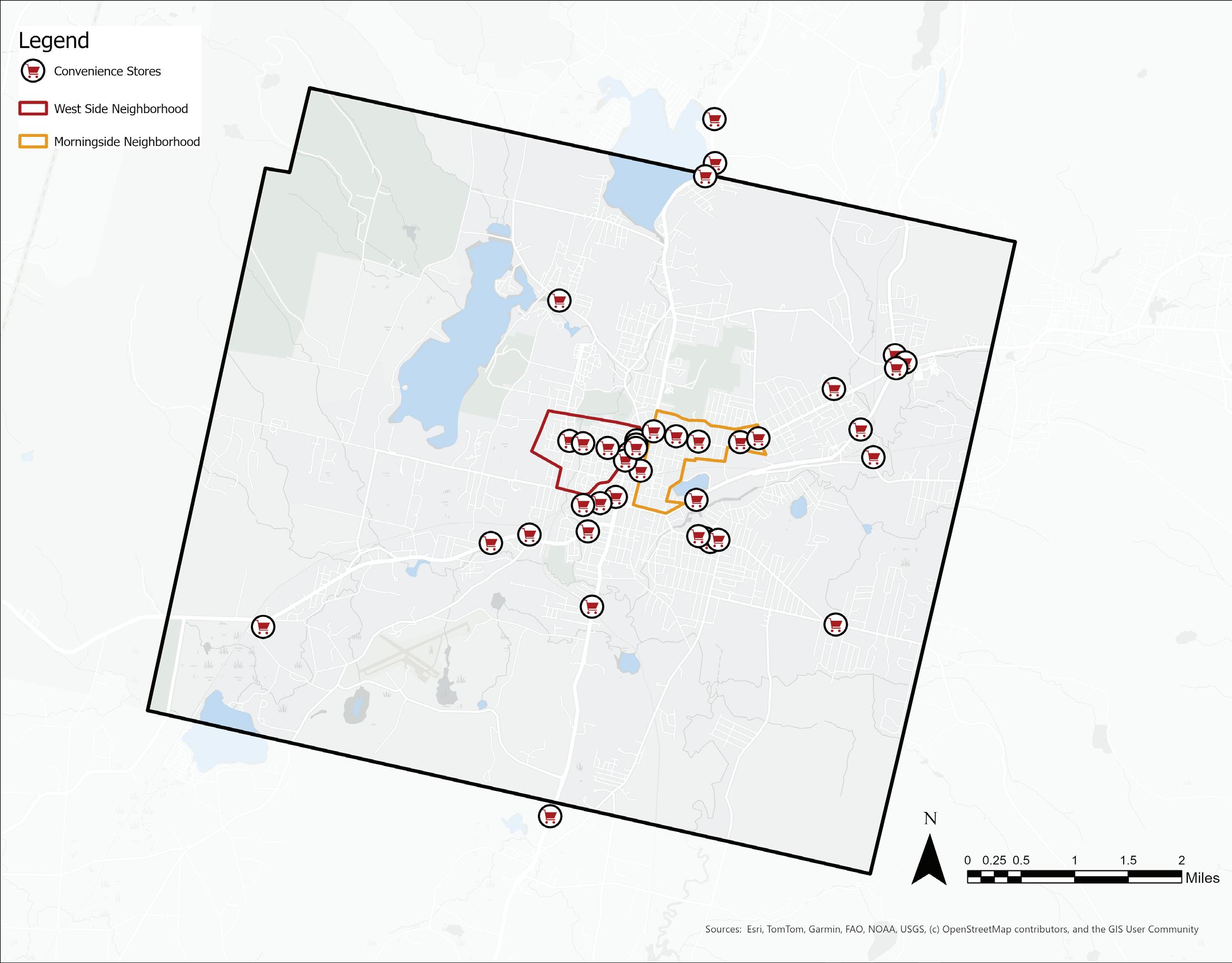
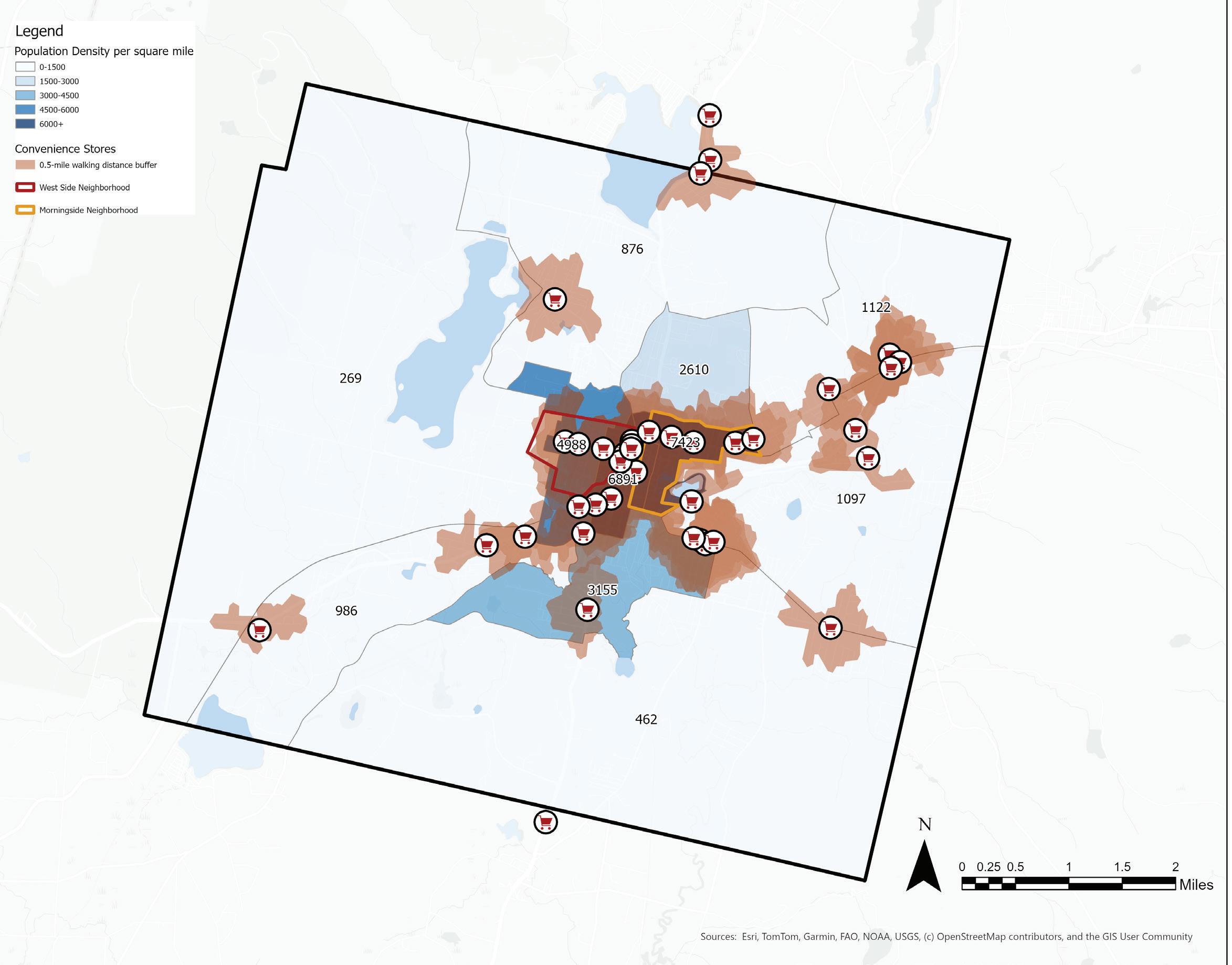
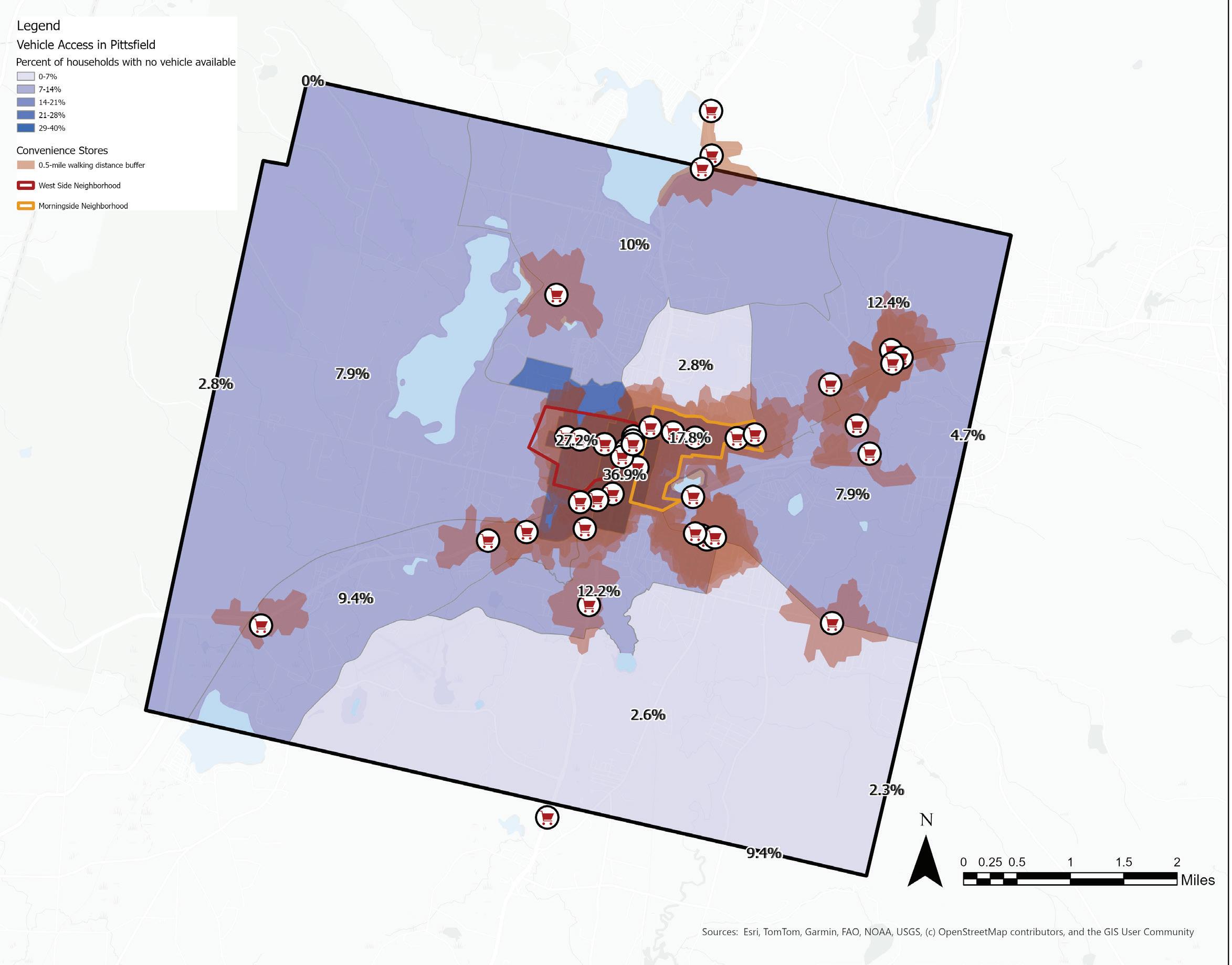
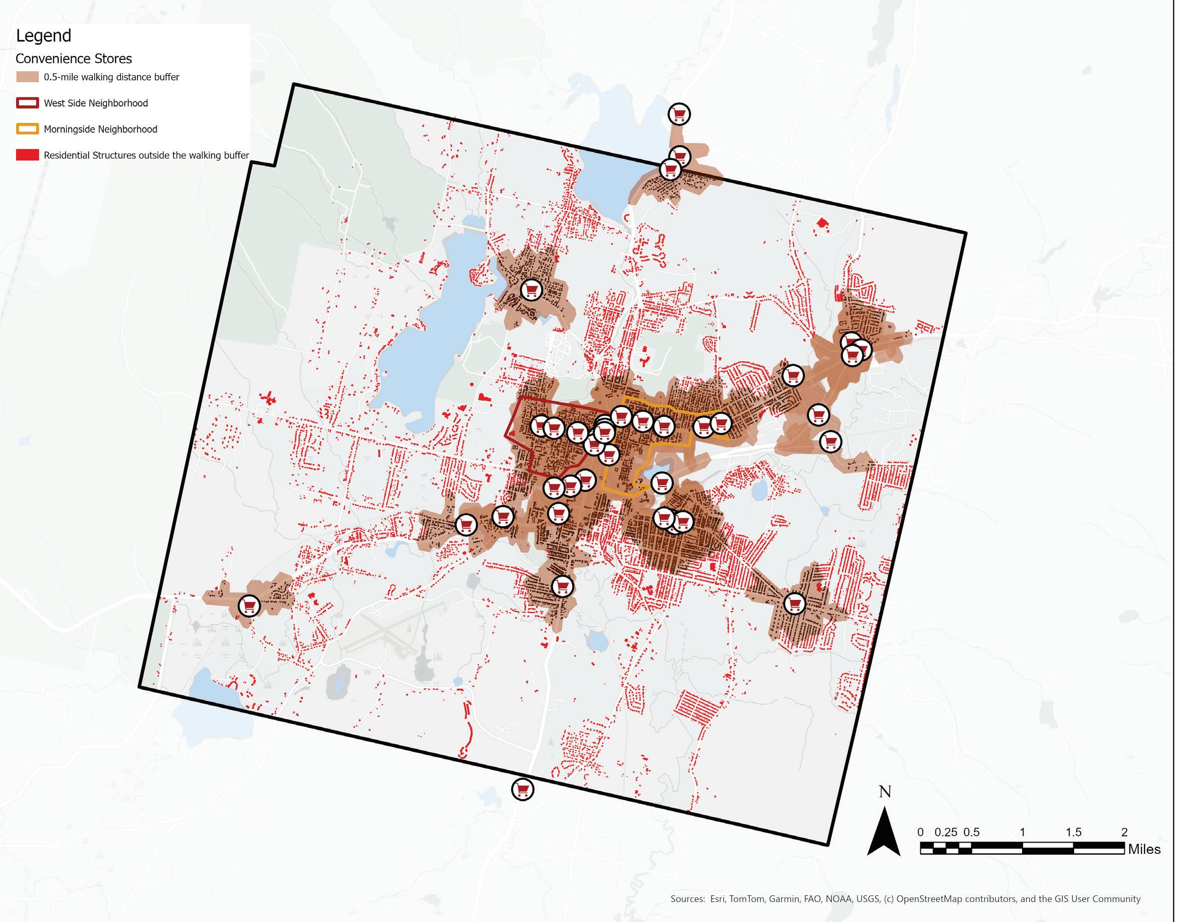
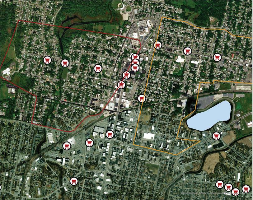
Retail Locations | Convenience Stores
Included in this map are all the corner stores and convenience stores (including dollar stores, pharmacies, and gas stations) that have limited or no access to fresh food. These types of stores also accept SNAP dollars. The corner/convenience stores may sell some local food or fresh food, however a store-by-store inventory of products would be required to assess the details of the food being offered.
When looking at a map of these establishments, what is visible is the abundance of corner/ convenience stores in the center of town and a lack of large retail grocery stores offering fresh food in the same region. This pattern is evident across
other cities in Massachusetts, where dollar stores are far more abundant in contrast to grocery stores and supermarkets (Massachusetts State Brief, 8).
While they lack access to fresh produce, these stores may be a critical source of food and other household necessities.
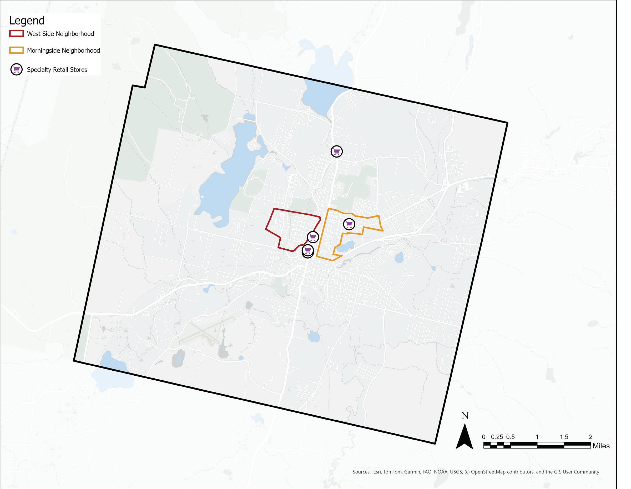
Retail Locations | Specialty Stores
Many of these specialty stores sell a mixture of prepared hot food and packaged grocery items that cater to many different cultural groups within Pittsfield. The stores listed on this map specialize in Brazilian, Latin American and African food. Further surveying would be required to assess the availability of fresh produce at the various speciality stores.
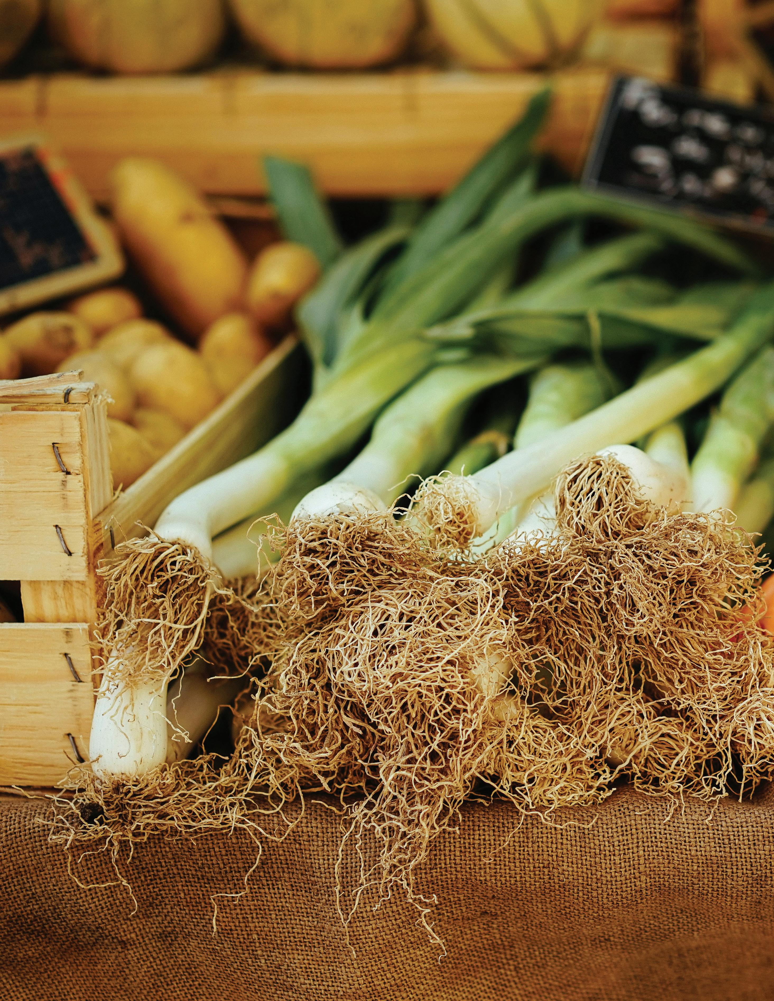
There is one farmers market in the downtown area that Roots Rising operates outdoors, weekly from MayOctober and indoors, monthly from November-April. It connects local producers and small scale value-added businesses within a 50 mile radius of Pittsfield to consumers in the city. SNAP, HIP, WIC and “market match” program dollars are accepted.
This map also shows seven local farms in Pittsfield. Many of them offer CSAs and operate farm stands seasonally or year-round. Some farms also offer farm tours, workshops, and pick your own programs.
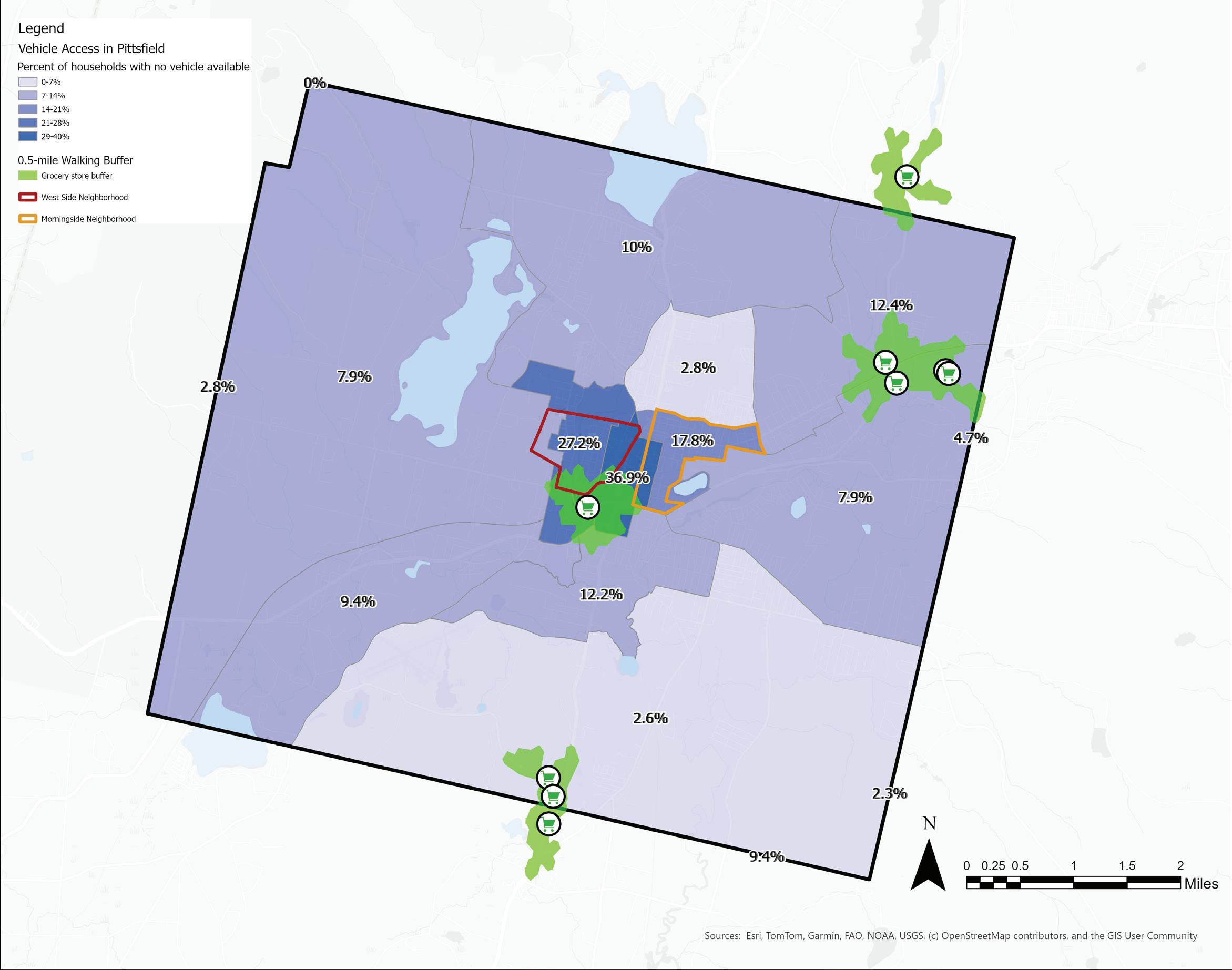
Grocery Stores and Median Household Income
In this section, the distribution of Pittsfield’s options for the retail purchase of food (grocery stores, supermarkets, and convenience stores) is overlaid with U.S. census demographic data, public transit, and residences to visualize the spatial barriers to accessing food.
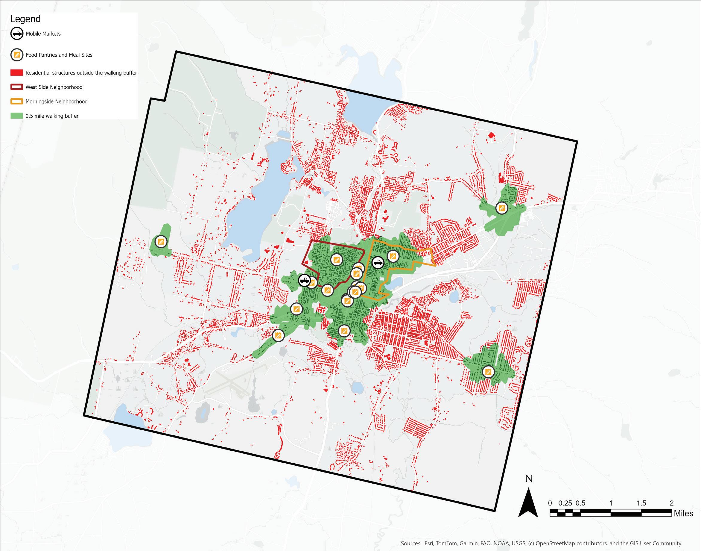
In the map above, the half-mile walking buffer is calculated using a GIS network analysis that approximates distance travelled on city roads/ sidewalks at a moderate walking pace of 3 mph (it would take 10 minutes to walk 0.5 miles). This halfmile walking distance buffer is applied to each of the stores. Overlaying the buffer with median income levels by census blocks reveals city wide patterns in retail food access.
The lower income census tracts that are in the center of town only have access to one grocery store and much of the area within these tracts does not fall within the half-mile walking distance buffer around the store.
Convenience Stores and Median Household Income
In contrast, there exists an abundance of convenience and corner stores in the center of town and much of the area within the low income tracts falls within the half-mile walking distance buffers of the stores.
Source: USDA
Grocery Stores and Population Density
Overlaying this half-mile walking distance buffer with a map of Pittsfield’s population density reveals a pattern of uneven distribution, where the most densely populated tracts of Pittsfield have the fewest options for fresh food and they are also located the farthest away from the concentrations of stores in the northeast and the south of Pittsfield.
The cluster of stores in the northeast and south of Pittsfield are along multi-lane, state-highways and hence may primarily be accessed by vehicles as opposed to residents accessing these stores on foot.
Source: USDA SNAP retailer locations, ACS population density by census tract
Convenience Stores and Population Density
In contrast, the neighborhoods with the highest population density have access to several convenience stores within a half-mile walking distance buffer.
Source:
Grocery Stores and Household Vehicle Access
This map shows the percentage of households in each census tract without access to a personal vehicle. Many of the households with no access to vehicles are located in the downtown census tracts, with only one grocery store in the vicinity. Residents outside the half-mile walking buffer may rely on other modes of transport like bicycles or buses.
Source:
Convenience Stores and Household Vehicle Access
Much of the area within the census tracts where residents have low access to vehicles intersects the half-mile walking distance buffer of the convenience stores. This suggests that the pedestrians without access to cars may have faster access to convenience stores over grocery stores in the region,
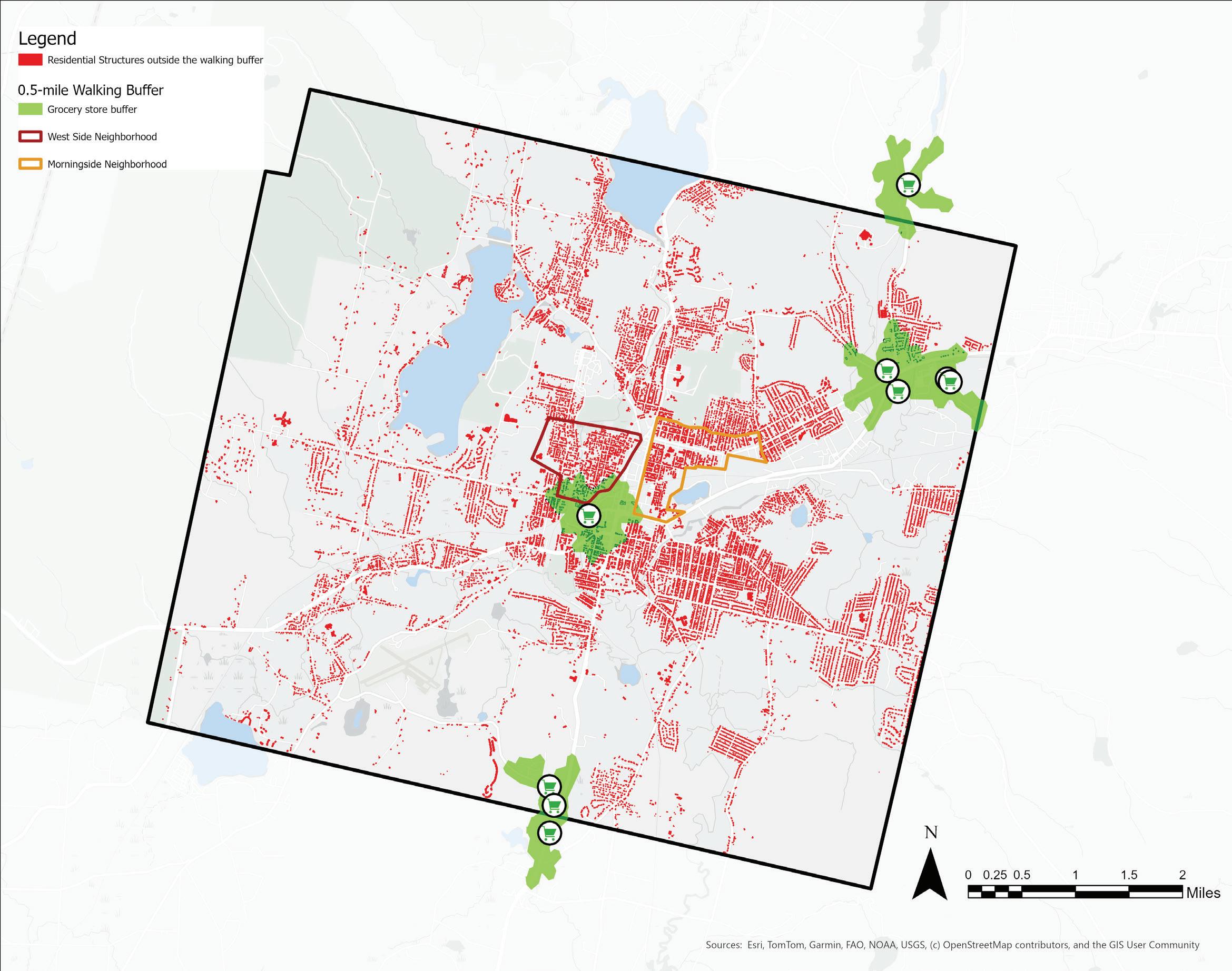
Residences within Walking Distance of Grocery Stores
Just about 3% of all residential structures (626 out of 20,307) lie within a half-mile walking distance buffer of the grocery stores with access to fresh food year round, while 97% of all residential structures (19,681 out of 20,307) lie outside of the same walking distance buffer. This suggests that a large percentage of Pittsfield’s population may rely on vehicular modes (personal vehicle, bus or food delivery) to access food through these stores. Also to be noted, residents with mobility restrictions and disabilities within the 0.5 mile walking buffer also likely rely on other modes of transport to access food.
To map residential structures, tax parcels with a use code tied to residential zoning were singled out and all the buildings and structures on the selected tax parcels were isolated. These structures were further clipped based on whether or not they fall in walking buffer zones around the stores.
Residences within Walking Distance of Convenience Stores
In contrast, about 45% of all residential structures (9,197 out of 20,307 structures) lie within a half-mile walking distance buffer of a convenience store, while 55% of all residential structures (11,110 out of 20,307 structures) lie outside of the same walking distance buffer.
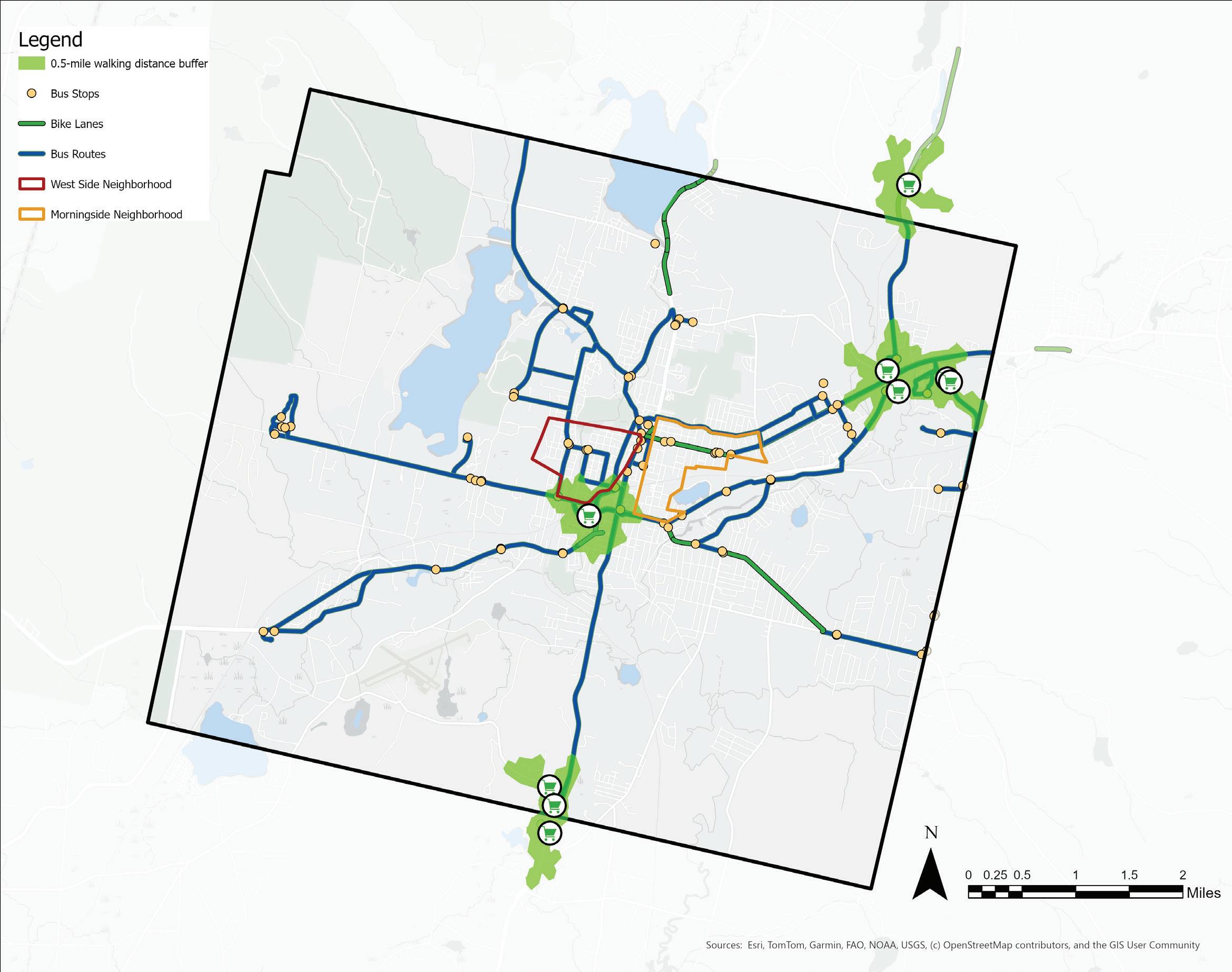
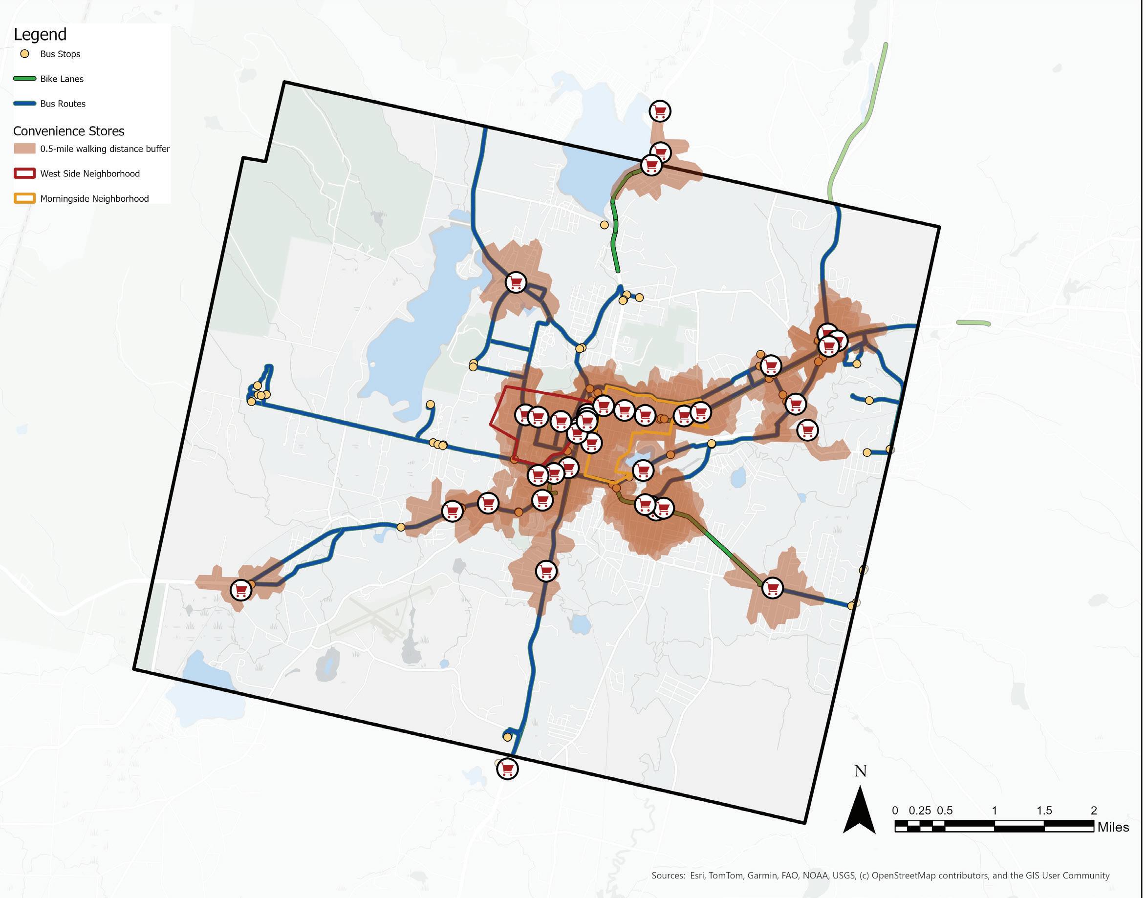
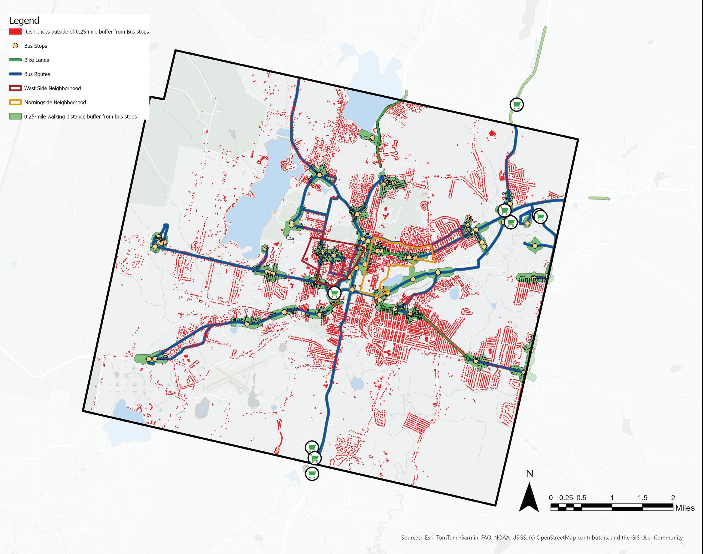
Grocery Stores, Public Transportation and Bike Lanes
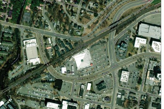
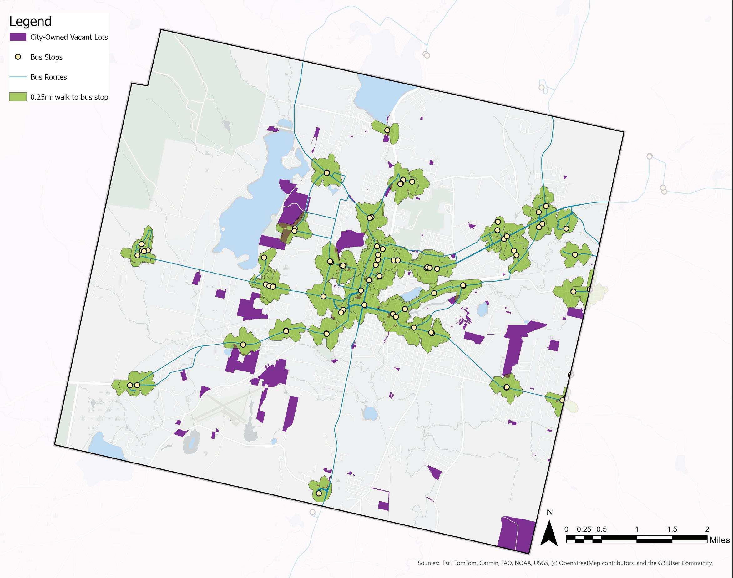
Those without access to a personal vehicle may use public transit and/or bicycles to get to the grocery stores. Although Pittsfield has a system of bus routes and a few bike paths, carrying bags of groceries may be difficult to do through both means of travel. The bike lanes in Pittsfield are fragmented and hence do not appear to be connecting many residents to and from the grocery stores in town.
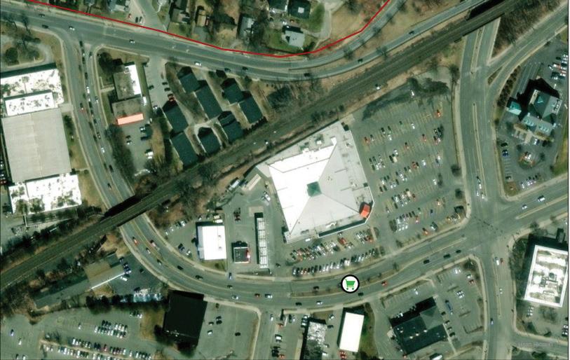
Residents may feel unsafe/uncomfortable using bike lanes near high speed, multi-lane roads like the ones surrounding the Big Y downtown. Berkshire Regional Planning Commission (BRPC) has identified these highways as a barrier to accessing
food and the footpaths connecting to the store are under consideration for redevelopment to make this site easier to access on foot for local residents (Frazier).
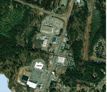
The Big Y downtown is surrounded by multilane highways on all sides.
Sources: USDA SNAP retailer locations, ACS household vehicle access by census tract, Bike lanes, RTA Bus Routes and Bus Stops
Convenience Stores, Public Transportation and Bike Lanes
In addition to being walkable to residents in the downtown area, the convenience stores also appear to be close to the existing network of bus stops. In comparison to the grocery store downtown, many of the downtown convenience stores are not located on busy, multi-lane highways and hence may be easier to access by bike.
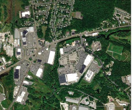
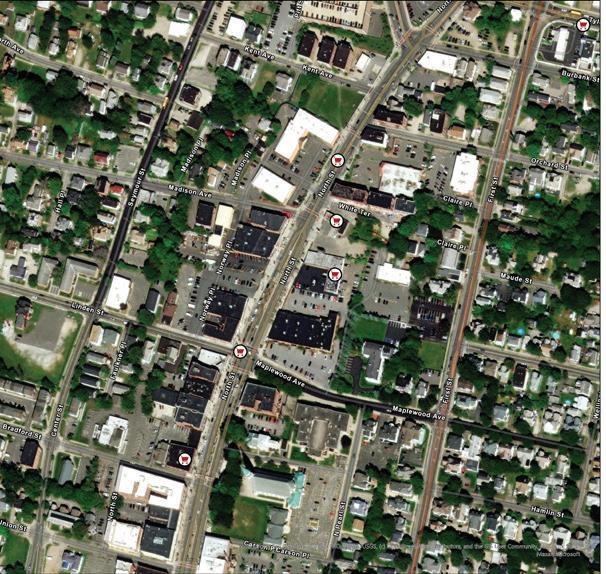
Many of the convenience stores are not adjacent to multi-lane highways like the Big Y downtown.
Sources:
Residences Outside Walking Distance of a Bus Stop
There are many residences that lay outside a quarter-mile walking buffer outside of a bus stop. BRTA also has a two-bag limit for passengers who are shopping and this may create an additional barrier to accessing retail food without a car.
Source: USDA SNAP retailer locations, MassGIS Structures 2-D, Bike lanes, RTA Bus Routes and Bus Stops
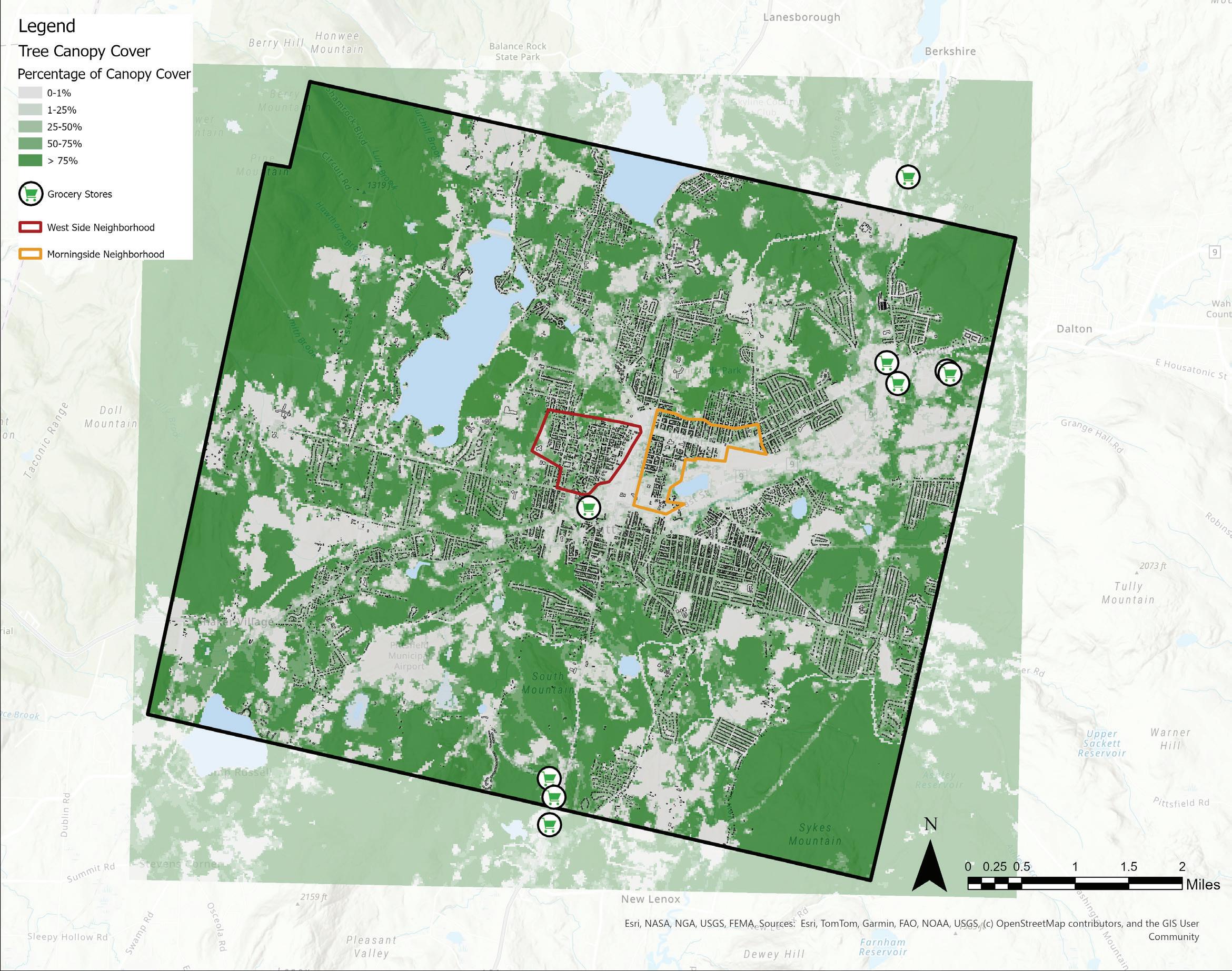
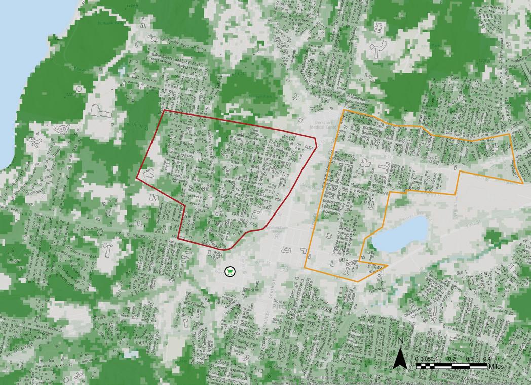
Grocery Stores and Tree Cover
This is map reveals the percentage of tree canopy coverage in Pittsfield. In the close up we can see that there is almost no tree cover around the Big Y grocery store downtown, implying that this might be uncomfortable for pedestrians to access on hot summer days (see map on the next page).
Source:
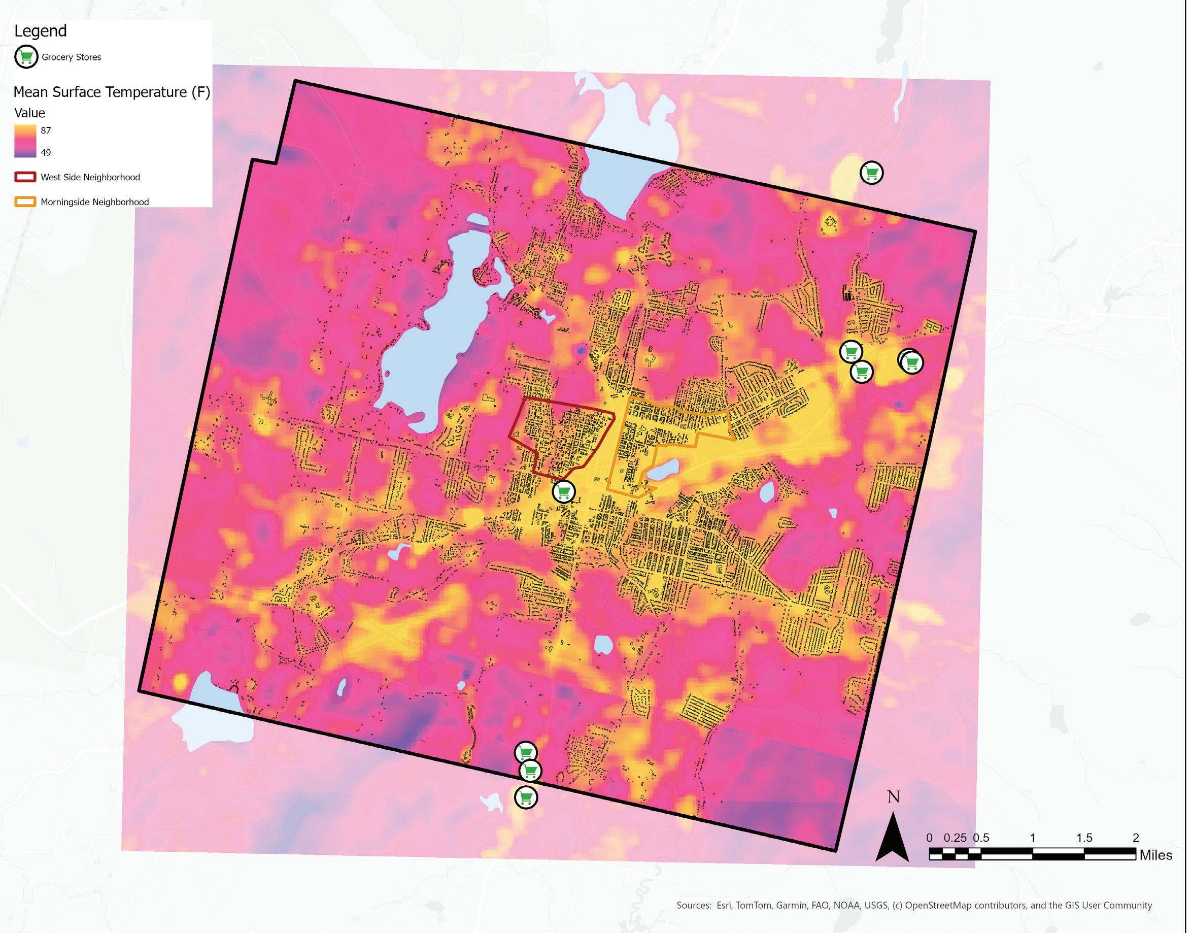
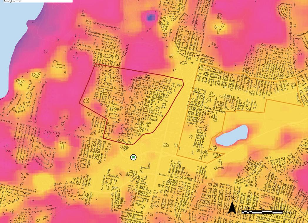
Grocery Stores and Mean Surface Temperatures
Mean surface temperature is calculated from average temperature recorded by Landsat 8 from 1972 to the present day. On average, the mean surface temperatures around the grocery store downtown and the cluster of grocery stores in the northeast of Pittsfield are relatively high (around 87F), which may be act as a barrier to access for pedestrians on foot, especially during the hot summer months.
RECOMMENDATIONS | IMPROVING FOOD ACCESS
The options explored below include siting new retail stores offering year round access to fresh foods, advocating for existing programs like HIP, and increasing the supply of fresh food offered through convenience stores.
IDENTIFYING IDEAL LOCATIONS FOR ADDITIONAL GROCERY STORES
The analyses suggest that the downtown area may benefit from the addition of a grocery store. While this section does not tackle strategies for attracting grocers, it does suggest a process for identifying locations that might best serve residences.
When exploring new locations for grocery stores, consider criteria such as:
• Areas where residents have low vehicle access
• Districts zoned for commercial or mixed-use development
• Areas outside of walking distance to existing retail locations
• City-owned vacant lots
Aside from traditional retail operations, Pittsfield’s residents may benefit from the establishment of worker or consumer owned cooperatives in the city. Cooperative grocery stores tend to value supporting local producers, which can help to build community wealth locally.
INCREASING FRESH FOOD AVAILABILITY IN CONVENIENCE STORES
Pittsfield’s residents may benefit from programs that increase the availability of fresh foods in convenience stores and corner stores.
These stores already accept SNAP benefits and are located within a half-mile walking distance of many residences in Pittsfield.
Pittsfield may benefit from a city-wide corner store survey to first gauge the interest in stocking fresh produce and the training and technological investment that may be required to facilitate the sale of fresh produce in these stores.
In June 2022, the Food Trust published a comprehensive guide on incentivizing the sale of fresh food in corner stores through two programs, nutrition incentives (similar to HIP and market match programs, supplementing existing SNAP budgets) and produce prescription projects (a partnership with healthcare professionals who can “prescribe” produce to eligible patients). The Food Trust acts as a platform to provide organizations and practitioners with technical assistance on implementing nutrition incentive projects.
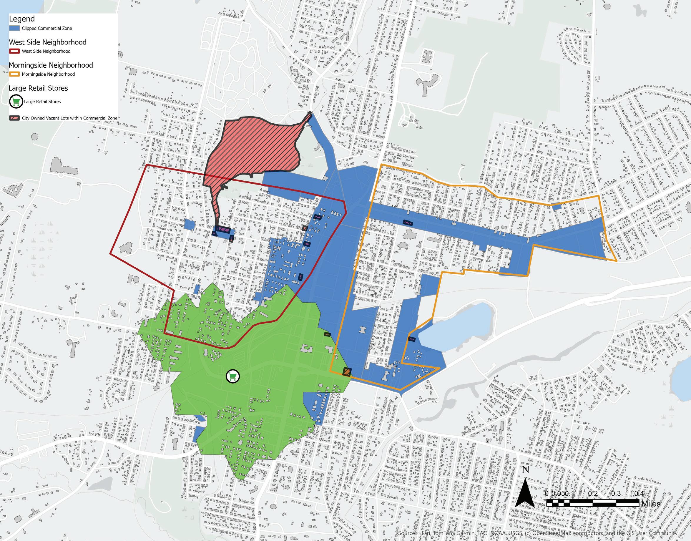
This map above overlays existing grocery stores with a half-mile walking distance buffer, with the commercially zoned areas in Pittsfield. The hatched areas are all parcels that are currently city owned lots. The area in blue, represents commercially zoned areas in downtown Pittsfield that may be considered for siting new grocery stores.
Source: USDA SNAP retailer locations, MassGIS
City of Pittsfield Zoning Districts and City-owned vacant lots
ADVOCATE FOR POLICIES AND PROGRAMS THAT SUPPORT LOCAL FRESH FOOD PURCHASING
Many policies and programs that support access to fresh food are currently under threat and advocating for their implementation is crucial to combating food insecurity amongst Pittsfield’s most vulnerable residents. HIP, Market Match, the Local Food Purchase Assistance Cooperative Agreement Program (LFPA) and the Local Food for Schools and Childcare Program (LFSCC) are some prominent examples of efforts that support the purchase of locally grown food.
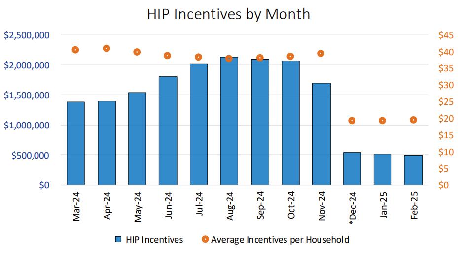
The HIP program has made tangible links between supporting local agriculture and addressing the disparity in fresh food access and due to recent cuts to the programs’ funding the MA Food System Collaborative is seeking public support for HIP enabling bills, H.222 and S.104 to match the preDecember HIP funding levels and establish a framework for the long-term sustainability of the program. The Massachusetts Food System Collaborative regularly updates the general public with information about HIP cuts and action steps to secure HIP funding on their website.
Currently, the statewide campaign coalition for HIP includes more than 300 farmers, farmers markets, nonprofit agricultural and food system organizations, faith based institutions, healthcare institutions, individuals with lived experience with food insecurity, and more. Pittsfield may benefit from allying with the coalition and attending the regular, virtual meetings to collectively advocate to lawmakers and to share updates about the program’s on the ground operation (Miller, “Campaign for HIP”).
In March, 2025 the USDA’s AMS (Agricultural Marketing Service) terminated the LFPA and LFSCC contracts with Massachusetts, slashing the funding that schools, food banks and child care facilities were awarded to purchase local foods. The National Farm to School Network is actively collecting public responses to document the scale and impact of the funding cuts. The organization maintains a web page to track the ongoing new coverage of the issue and also lists action steps in support of these funding efforts (NFSN, “Action Alert!”).
Graph highlighting the difference in HIP incentives spent over the fiscal year 2024-25. Source: Department of Transitional Assistance
Community Spotlight: Berkshire Food Co-Op
The Berkshire Food Co-op is owned by many members of the community who directly depend on the services offered and not outside investors or corporations. The co-op purchases more local, sustainably grown produce, invests more on their employees and local economies, offers more discounted groceries and has higher rates of recycling and energy conservation than their conventional counterparts. Cooperatives such as these often look to eight guiding principles that help establish a democratic structure of governance:
• Voluntary and Open Membership
• Democratic Member Control
• Members’ Economic Participation
• Autonomy and Independence
• Cooperation Among Cooperatives
• Concern for Community
• Diversity, Equity & Inclusion
Source: Berkshire Food Co-op, “Community Owned Since 1981”
Community Spotlight: Daily Table, A Non-Profit Grocery Chain
The Daily Table is a chain of grocery stores that was founded in 2012 and has grown to 4 retail locations in Dorchester, Roxbury, Cambridge and Salem. They believe that everyone deserves access to fresh nutritious food at affordable prices. Through a unique model of acquiring donated and discounted food from suppliers, securing philanthropic support and operating as a non-profit, they are able to pass down an average of 30% lower prices on their products for customers. All products in store are SNAPeligible and in 2018, in partnership with the Fair Food Network and the Mayor’s Office of Food Access they were able to launch the Double Up Food Bucks program in store, to offer all participants who are eligible for SNAP double the benefits when they shop (Daily Table, “2024 Impact Report”).
THE EMERGENCY FOOD NETWORK
As more residents lose access to food assistance dollars, they are turning to the robust emergency food network in Pittsfield that provides food, usually free of cost, to those who are most in need. This emergency food network comprises pantries, meal sites, delivery programs, mobile markets, brown bag programs, and school lunch programs. Residents can usually access these services free of charge.
Both the City of Pittsfield and the Food Bank of Western Massachusetts maintain a virtual list of pantries, meal programs and mobile markets and their specific times of operation that is regularly updated to reflect changes in the network.
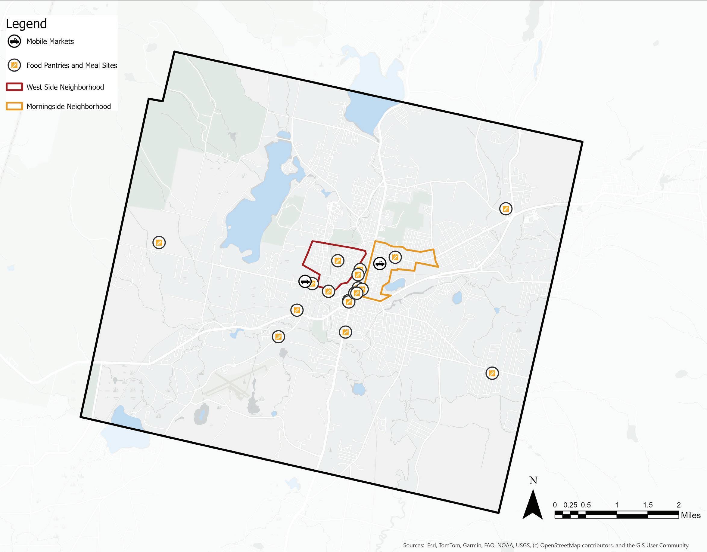
Pantries and Mobile Markets
Pittsfield has 13 food pantries, five meal sites, a few mobile farmers markets, school meal programs, a brown-bag program for senior citizens and meal delivery services that make up the city’s emergency food network.
The following pages overlay these emergency food site locations with U.S. Census data, public transit and residential structures to visualize any spatial barriers to food access in the emergency food network.
City of Pittsfield pantries and meal sites, Berkshire Mobile Farmers Markets
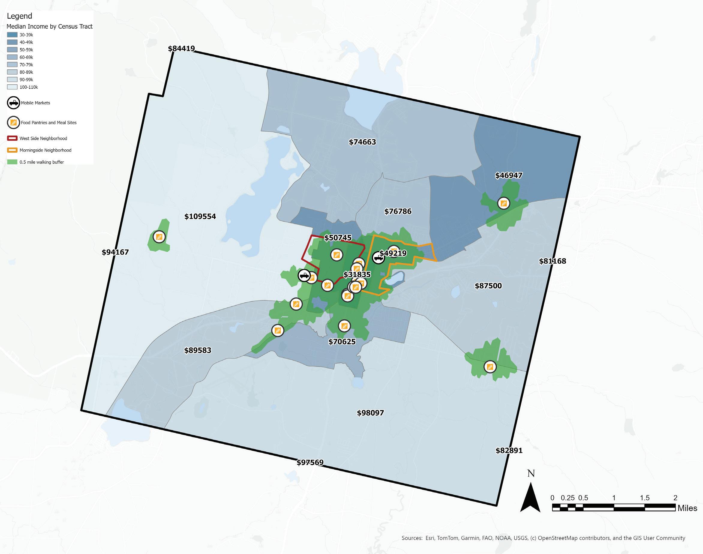
Emergency Food Sites and Median Household Income
In contrast to the retail locations in the city, the emergency food network sites are much more numerous and within walking distance of the many residents who are living in lower income census tracts downtown.
Sources:
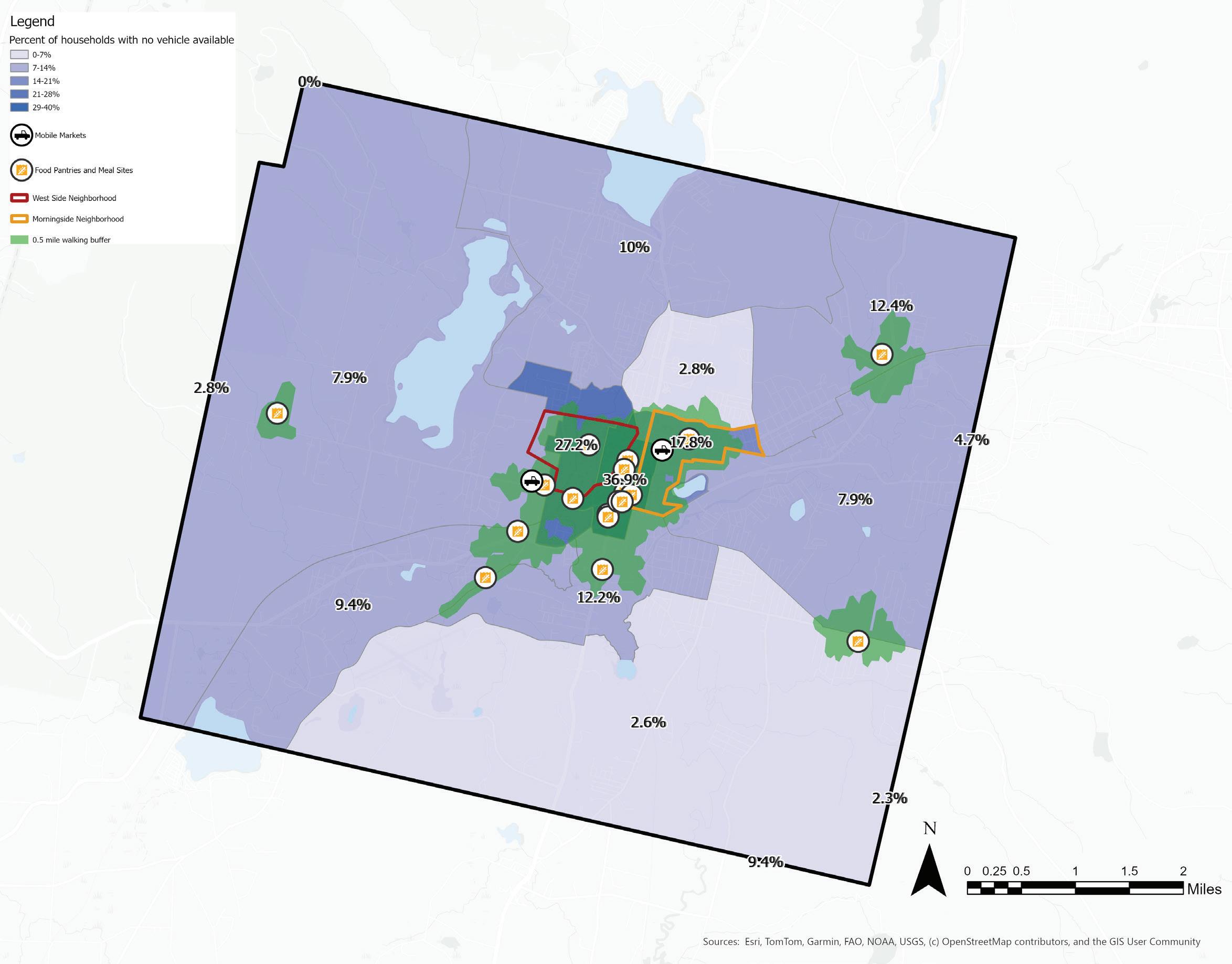
Emergency Food Sites and Household Vehicle Access
Much of the area mapped as having low vehicle access overlaps with the walking buffer around emergency food sites. Many low income residents and residents without access to vehicles are located within a half-mile walking buffer of the emergency food sites. However, access is not available uniformly throughout the week as these food sites do not have the same days/times of operation.
Sources:
Residences Outside Walking Distance of a Food Pantry
Around 22% of all residential structures (4,476 of 20,307 structures) lie within a 0.5-mile walking distance buffer of the emergency food sites, while almost 78% of the residential structures (15,831 of 20,307) structures lie outside the same walking distance buffer.
Sources: City of Pittsfield pantries and meal sites, Berkshire Mobile Farmers Markets, MassGIS structures 2-D
The Regional Emergency Food Network
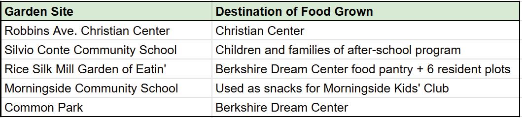
The emergency food sites in Pittsfield are stocked with food from a number of different sources. There is local food sourced directly from Pittsfield and farms around the county, there are donations from retail locations, the farmers market, donations from food drives organized by corporate/civic organizations, donations from community gardens, church gardens, as well as donations from individuals that all make it into the pantries of Pittsfield.
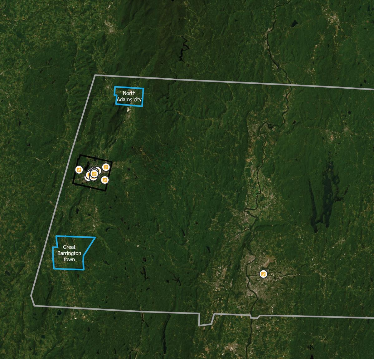
According to the Food Bank of Western Massachusetts, visitors to pantries in Pittsfield have risen almost 86% since 2021, as reflected in the rise in monthly visitors from 7,000 per month to roughly 13,000 per month (Food Bank of Western MA, “Hunger and Its Causes”). In the last year alone, Berkshire Bounty has reported a 60% increase in food pantry usage across the 11 Pittsfield food pantries they work with, there has been a 60% increase in food pantry usage from 2024 to 2025 (Berkshire Bounty, personal communication, April 7, 2025). Many of the stakeholders engaged have reported on the stress that the emergency food network is facing due to increasing number of residents who require emergency food assistance. This map explores the existing regional infrastructure that supports large-scale emergency food distribution and the vulnerabilities this system might face.
Aside from the food that is sourced locally, a large portion of the food that stocks Pittsfield’s pantries arrives from the Food Bank of Western Massachusetts. Once a week, a truck drives from Chicopee to Pittsfield and delivers food that pantries across the entire county depend on. The Food Bank is reported to be serving roughly 13,000 residents in per month with the food arriving each week from Chicopee. Pittsfield, however, has no capacity for the cold storage of emergency food. Thus the capacity to stockpile essentials to meet growing demands and remain resilient in the face of logistical challenges or delays is very limited in
The weekly trip made by a delivery truck from Chicopee to Pittsfield.
Food Bank of Western Massachusetts, Chicopee
Pittsfield
RECOMMENDATIONS | EMERGENCY FOOD NETWORK
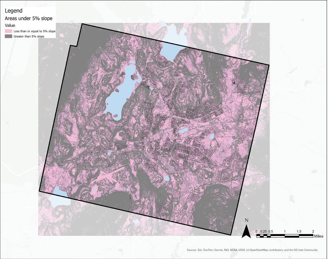
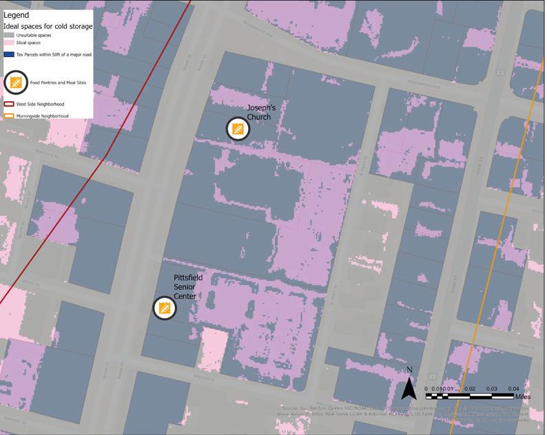
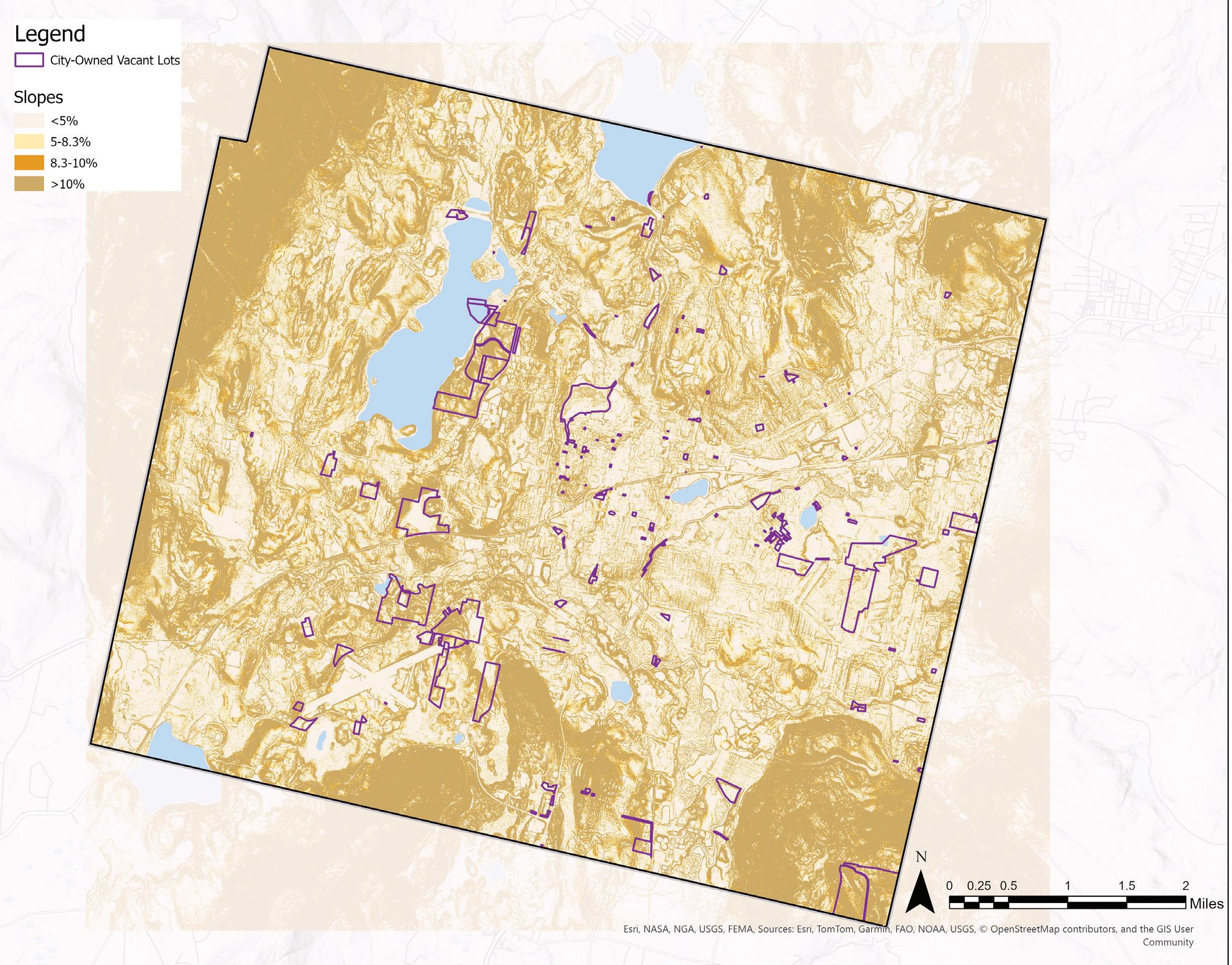
Cold storage units have the capacity to store fresh produce as the need for food within the emergency food network steadily rises. Critical criteria when siting a cold storage facility include:
• Access to the power grid
• Sited on an impervious surface (for regular/ heavy truck access)
• Sited on cleared land (so no tree removal is necessary for siting)
• Easy truck access (e.g.: proximity to major roads/a loading area)
• <5% slope (areas with a reduced need for extra grading/earthwork)
• Proximity to existing pantries
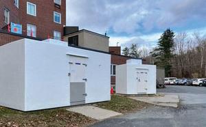
Community Spotlight: Cold Storage in North Adams
In 2023, Berkshire Bounty acquired a refrigeration unit and walk-in freezer for cold storage through a food security infrastructure grant. The benefits of installing these units in North Adams have included :
• An added capacity to stockpile emergency food as demand for food rises across the city;
• The ability to
• Prioritize stocking locally grown produce;
• Extended shelf life for pantry items; and reduced food waste (Berkshire Bounty, “Annual Report 2023).
Freezer and refrigeration units in Pittsfield may benefit the community in similar ways as the immediate need for food in the emergency food network grows.
The maps on the right show aspects of Pittsfield in a binary distribution, revealing the areas that are above and below 5% slope, impervious or porous surfaces, and areas that are forested or cleared of trees.
These patterns of distribution can be overlaid with all the tax parcels that are close to major roads to identify areas suitable for cold storage units. Many of the ideal parcels may already be in use, however, this map allows us to identify potential community partners who may already serve as a food panty or have a connection to the electric grid and sufficient outdoor space for the units. EXPLORE OPTIONS FOR COLD STORAGE
Source: Berkshire Bounty Annual Report 2023
Slope<5%
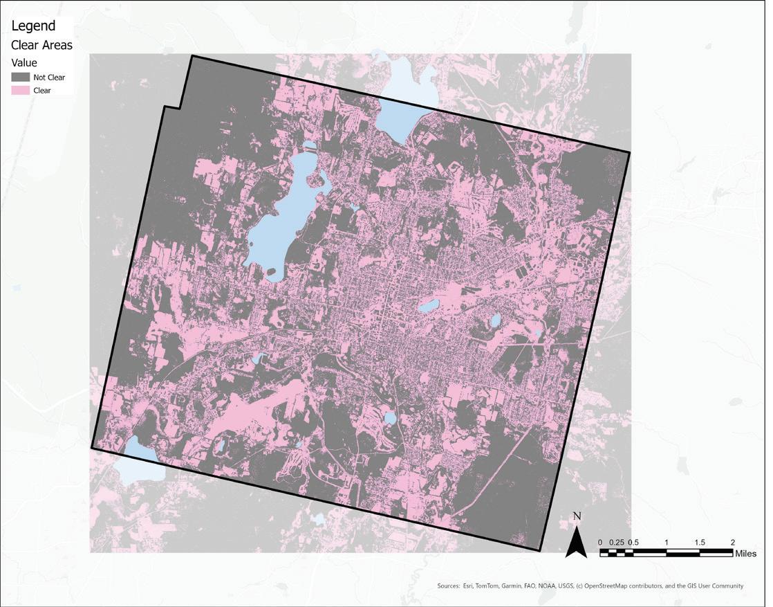
Clear Areas
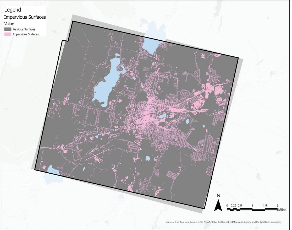
Impervious surfaces
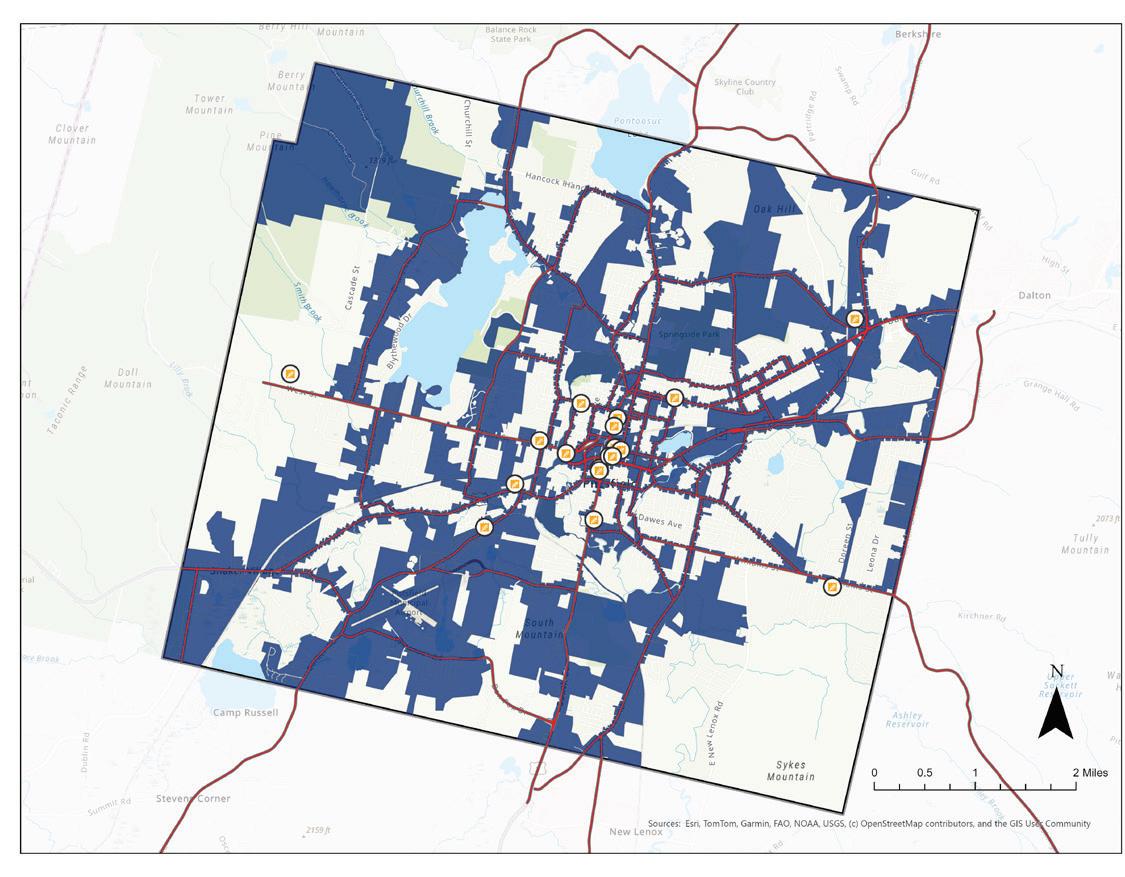
Tax Parcels within 50 feet of a major road
Potential Cold Storage Parcels
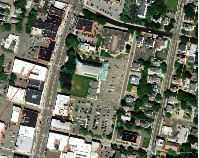
2 examples of suitable cold storage locations identified in the parking lots of Pittsfield Senior Center and Joseph’s Church
Map overlaying desirable criteria and all the tax parcels within 50 feet of a major road
Sources: City of Pittsfield pantries and meal sites, MassGIS tax parcels
FOOD PRODUCTION | PITTSFIELD & THE BERKSHIRES
Home to 475 farms, Berkshire County produces a diverse array of goods despite a cold climate and steep terrain. According to a 2011 Williams College study, Berkshire County has enough land to feed all of its residents, and that the existing supply does not meet demand for cereal and bakery products, beef products, pork products, fruits, berries, and vegetables (Berkshire Regional Planning Commission).
As the birthplace of the community-supported agriculture (CSA) model, the Berkshires have a long history of fostering direct relationships between small farmers and consumers. According to Berkshire Grown, there are 17 farms currently operating CSAs in Berkshire County, two of which are located in Pittsfield. Several nonprofit organizations including Berkshire Agricultural Ventures, Berkshire Community Land Trust, and Berkshire Grown help farmers reduce costs and access markets.
There is a growing number of farmers under the age of 40, according to a survey done by Sustainable Berkshires, and community members have noted that land access is the primary barrier to continued farming, as opposed to lack of interest from the next generation.
Farms in the Berkshires are also a component of the region’s tourism economy, with 2.6 million people visiting the Berkshires each year. Several farms in the Berkshires use a business model called agritourism which involves special programming geared towards visitors.
In interviews conducted during the winter of 2025 at the Pittsfield farmers market and with individual farmers around Pittsfield, farmers in the Berkshires shared challenges that they face such as land access; rising costs of land, labor, and equipment; a competitive and inaccessible market; and a culture increasingly disconnected from agriculture. Soaring land prices are a major barrier to starting a farm, leading many farmers to rely on secondary jobs to sustain their operations.
Berkshire County is flanked by two agriculturally productive river valleys: the Hudson Valley to the west and the Pioneer Valley to the east. Farms in these fertile regions have a significant comparative advantage in conventional crop cultivation compared to the mountainous Berkshires.
Limited cooperative infrastructure makes it difficult for small farms to collaborate on production and aggregation, preventing them from achieving the economies of scale necessary for supplying grocery stores and institutions. Additionally, farmers worry that consumers don’t understand food production, undervaluing the importance of sustainably and locally grown goods. One farmer shared, “how could you eat something you don’t know?”
While this report does not exhaustively explore all of the challenges to farm viability in the Berkshires, this section’s inventory and analysis attempts to establish a working understanding of farmland and crop production in Pittsfield and the Berkshires.
The following inventory reveals a context of a declining supply of farmland coupled with increasing farmland costs in the region that is a financial viability constraint on the livelihoods of aspiring and established farmers.
Despite its challenges, cultivating opportunities for increased food production in Pittsfield supports local resilience in the face of unpredictable supply chains and changing climate conditions by providing a food supply that's close to home and can meet the needs of the community. Partnerships between farmers and local institutions or emergency food distributors can support food access for community members, while alternate food production models like community farming can give people decision-making power over local food production, provide opportunities for skills development, and allow for the cultivation of culturally appropriate crops.
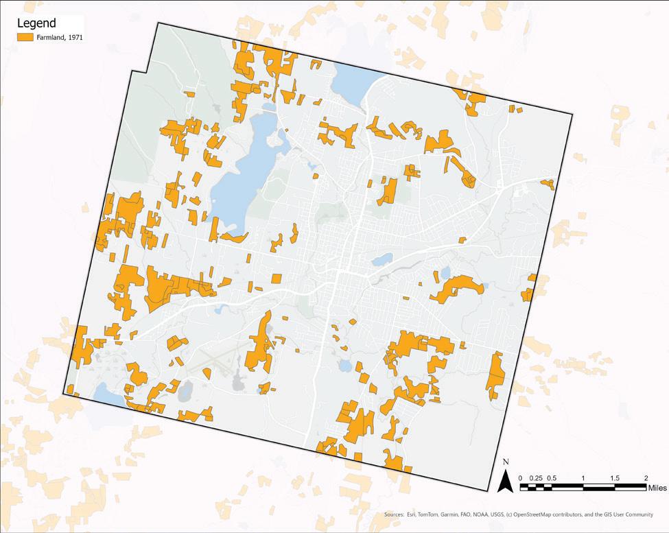
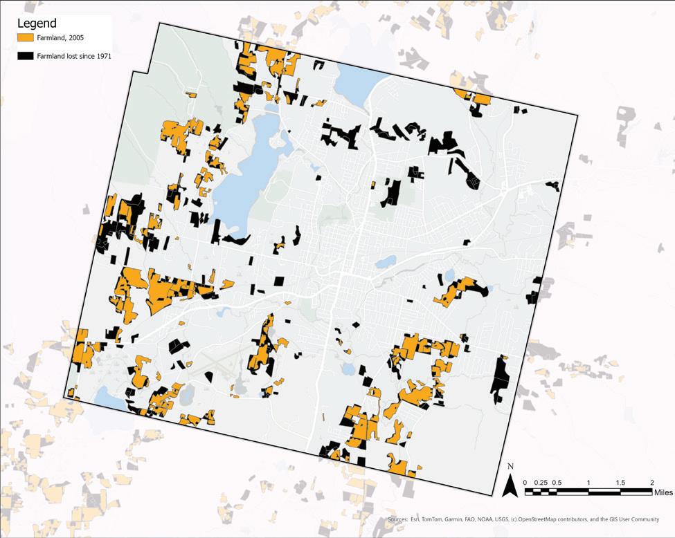
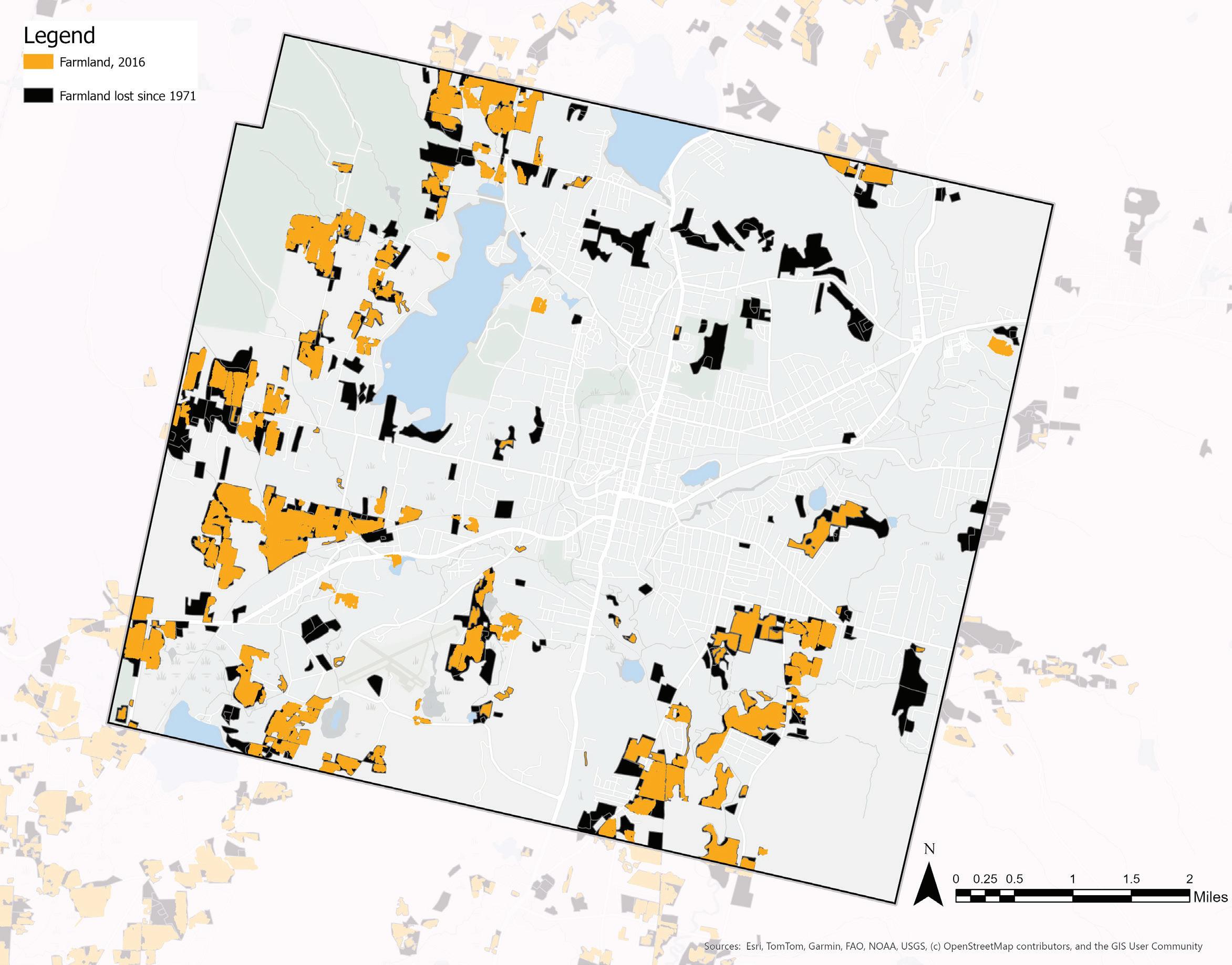
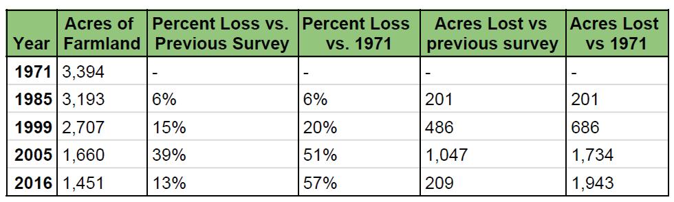
FARMLAND LOSS, 1971-2016
Farmland is under threat across New England. Between 2001 and 2016 alone, over 105,000 acres of agricultural land was lost or faced development threats in the six New England states (Farms Under Threat). This trend is apparent in Pittsfield, as shown by the series of maps below, displaying active farmland in five MassGIS land-use surveys in five different years: 1971, 1985, 1999, 2005, and 2016. Active farmland (combined cropland and pasture land) is shown in orange, while black indicates farmland that has been converted to another use type since 1971. The results are striking: as of 2016, Pittsfield has lost 57% of its farmland since 1971. This amounts to nearly two thousand acres in just forty-five years. Urban farmland in particular has suffered from development pressures, while farmland farther from the city center appears more intact. The northeast quadrant of the city has lost nearly all its farmland. However, in wider Berkshire County, farmland acreage is actually on the rise, with a 23% increase in acreage between 2017 and 2022 (USDA NASS).
Source : MassGIS Land Use (1951-1999)
In 1971, there were nearly 4,000 acres of active farmland in Pittsfield, with tracts generally increasing in size the farther they are from the city center.
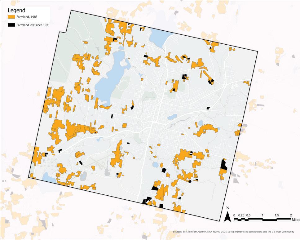
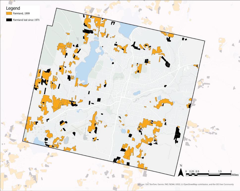
By 1999, Pittsfield had lost one-fifth of its farmland, with large and small parcels being converted to alternate use types.
Source : MassGIS Land Use (1951-1999)
More than 200 acres of farmland were lost between 1971 and 1985, with tracts of various sizes going offline.
Between 1999 and 2005, Pittsfield lost over 1,000 acres of farmland, notably in present-day Springside Park, and the majority of farmland in Pittsfield’s northeast quadrant. Tracts closer to downtown were also converted during this time.
Source : MassGIS Land Use (2005)
By 2016, Pittsfield farmland was reduced from 3,394 acres to just 1,451 acres. Nearly 2,000 acres were converted to other use types, ranging from municipal open space (like Springside Park), forested area, grasslands, and residential parcels.
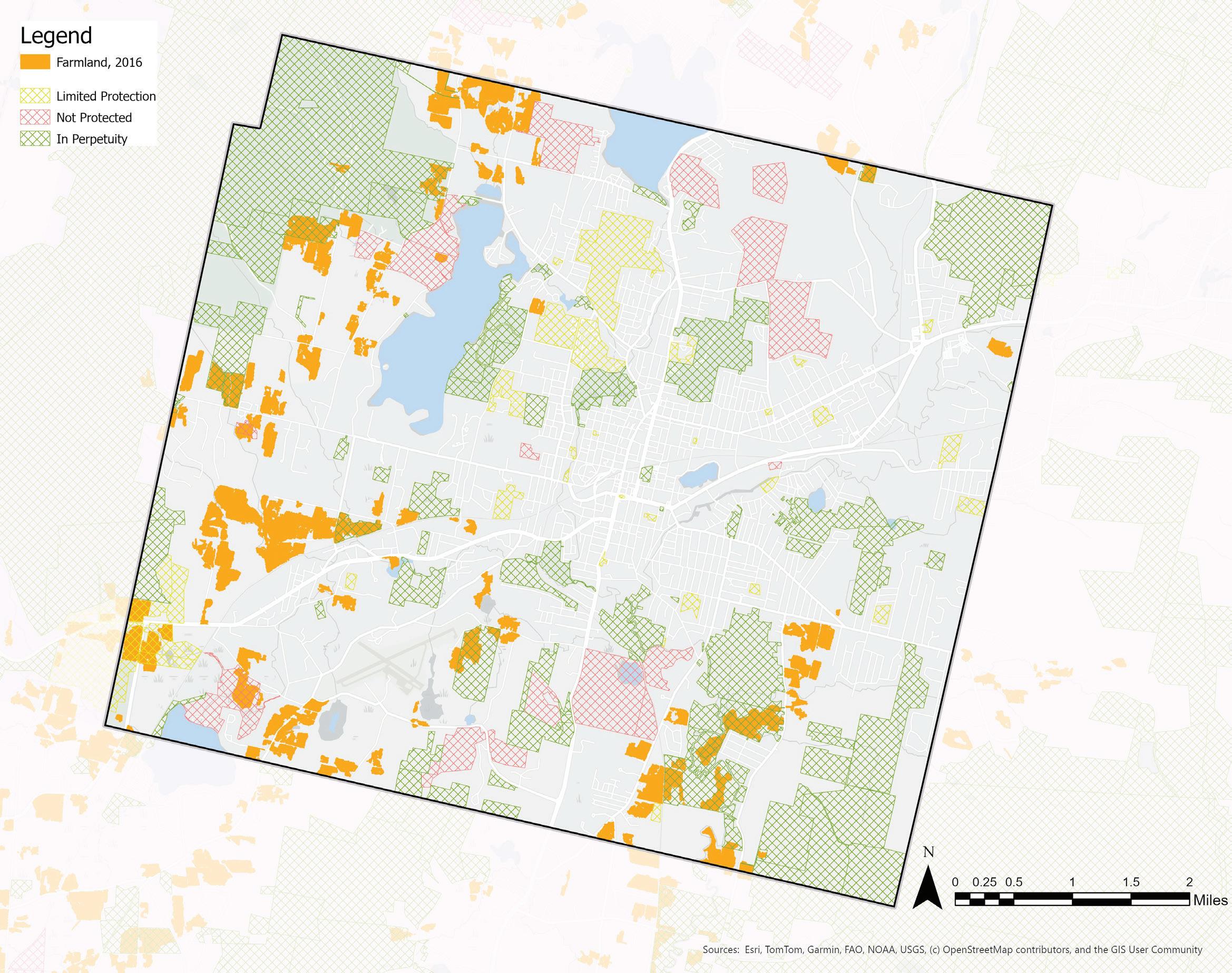
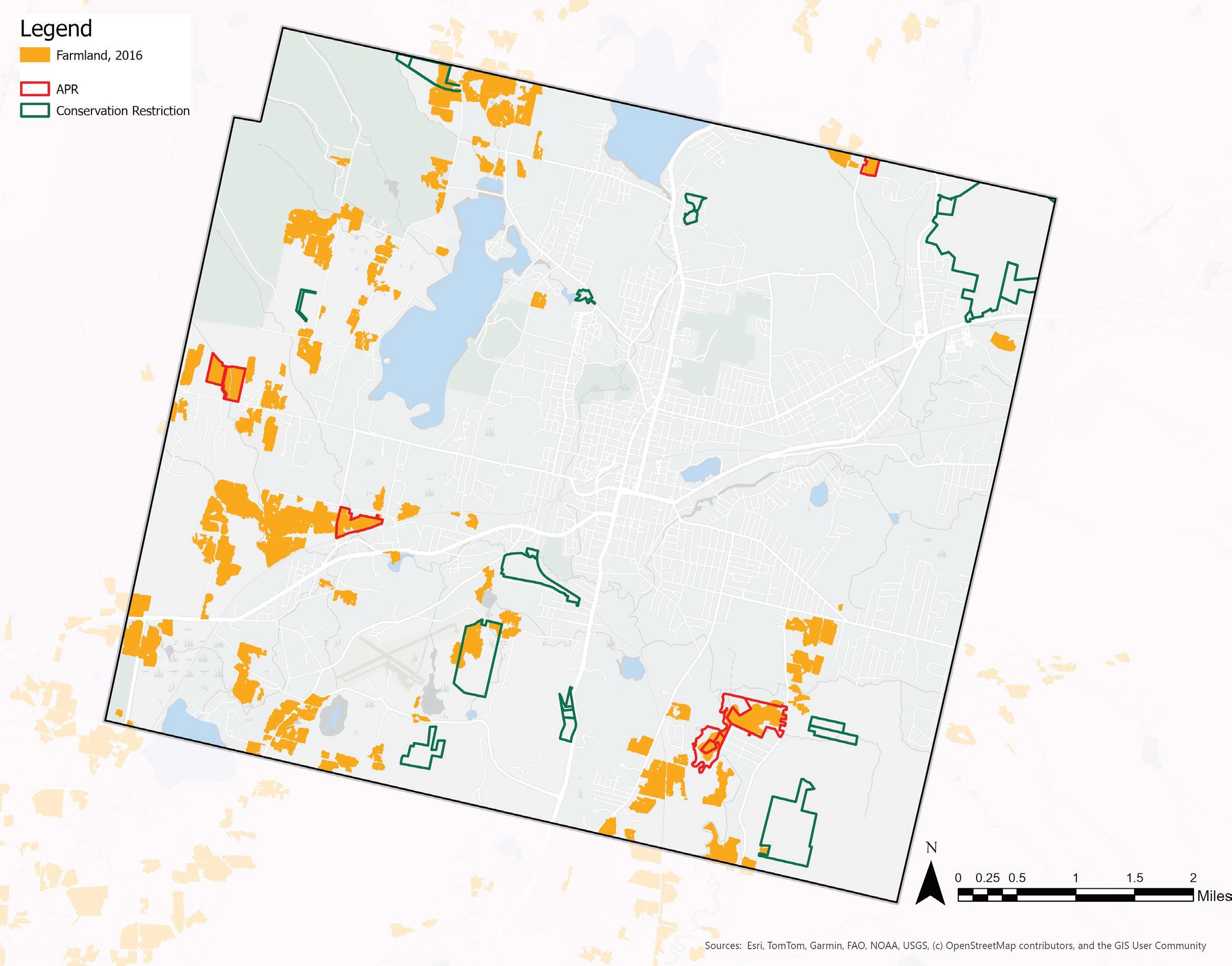
There are many acres of protected open space in Pittsfield, ranging from limited to permanent protection. These protection measures include Agricultural Preservation Districts (APRs), Conservation Restrictions (CRs), and Chapter 61 lands, among others. 397 acres of Pittsfield farmland, or 27%, is protected in perpetuity, while 87 acres, or 6%, is under limited protection. Overall, one-third of Pittsfield’s farmland is under protection, leaving two-thirds of farmland vulnerable to development or conversion to other land use types.
LAND PROTECTION TOOLS
Of the remaining farmland in Pittsfield, only 15% is protected under Agricultural Preservation Restrictions (APRs), which ensure that land will remain under agricultural uses in perpetuity. Similarly, Conservation Restrictions (CRs) protect land from development. While not always specific to farmland, CRs are another tool to preserve agricultural use. There is minimal farmland that lies under CRs in Pittsfield. If ensuring the continuation of food production in Pittsfield is desired, farmland should be protected under APRs and other legal tools. In order to expand farmland protections, Pittsfield farmers need to be aware of available resources and their financial and ecological implications.
LAND COSTS
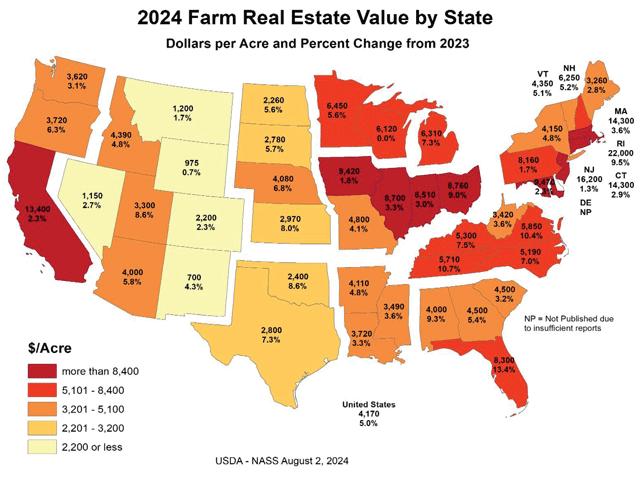
Shrinking number of acres of farmland corresponds with increases in average price per acre of farmland. Massachusetts farmland is the third most expensive in the country, averaging $14,300 per acre in 2024, which is up 3.6% from 2023 (USDA). Increasing land value raises the up-front cost for the next generation of farmers, and attracts developers looking to convert farmland to alternate use types. The average value of residential sales in Pittsfield have risen 65% between 2019 and 2025 (Carroll 2024), illustrating the rising home prices that may be driving the subdivision of farmland. According to stakeholder interviews, farmers are facing increasing pressure to sell some or all of their land in order to make ends meet.
Case Study:
Farmland Preservation on Oblong Road, Williamstown Massachusetts
In 2022, a 10 acre parcel of farmland on Oblong Road in Williamstown, Massachusetts, faced potential residential development. When the owner decided to sell the land, its status under Massachusetts’ Chapter 61 program granted the town the first right of refusal. The Select Board voted to assign this right to Williamstown Rural Lands Foundation (WRLF), enabling the foundation to negotiate directly with the seller. WRLF embarked on a fundraising campaign, securing over $438,000 in donations and pledges from community members, particularly those residing on Oblong Road. This demonstrated strong local commitment to farmland preservation. The collaborative efforts culminated in the successful conservation of the 10 acre parcel, ensuring its continued use for agriculture.
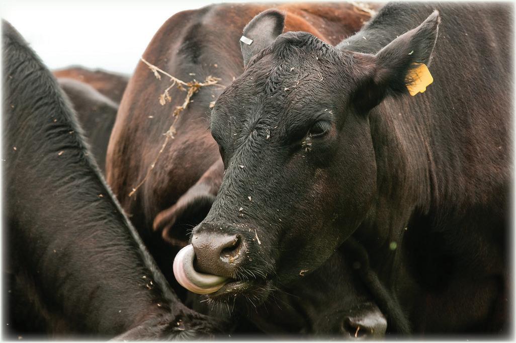
The Sweet Brook Beef Company’s farm is located adjacent to the 10-acre parcel. They raise black Angus cows, like shown here. “20130712-AMS-LSC-0424” by USDAgov is marked with Public Domain Mark 1.0.
EXISTING FARM INVENTORY
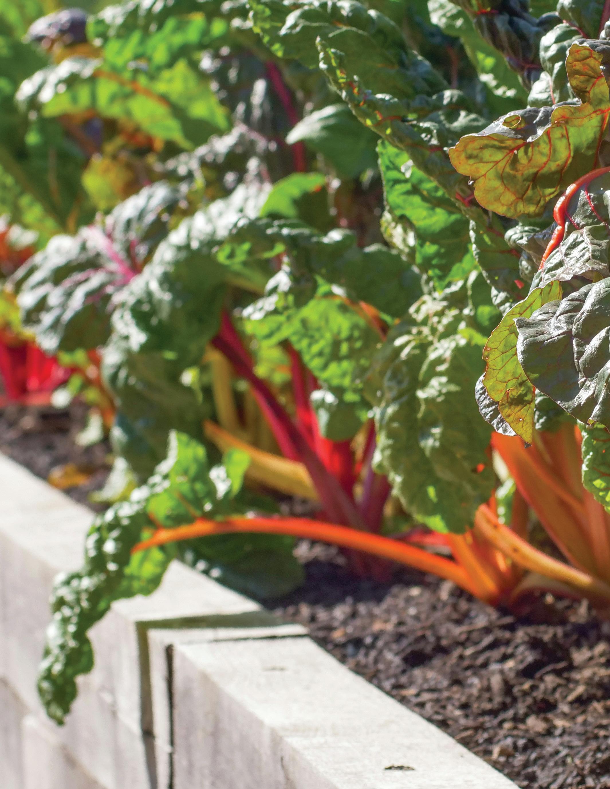
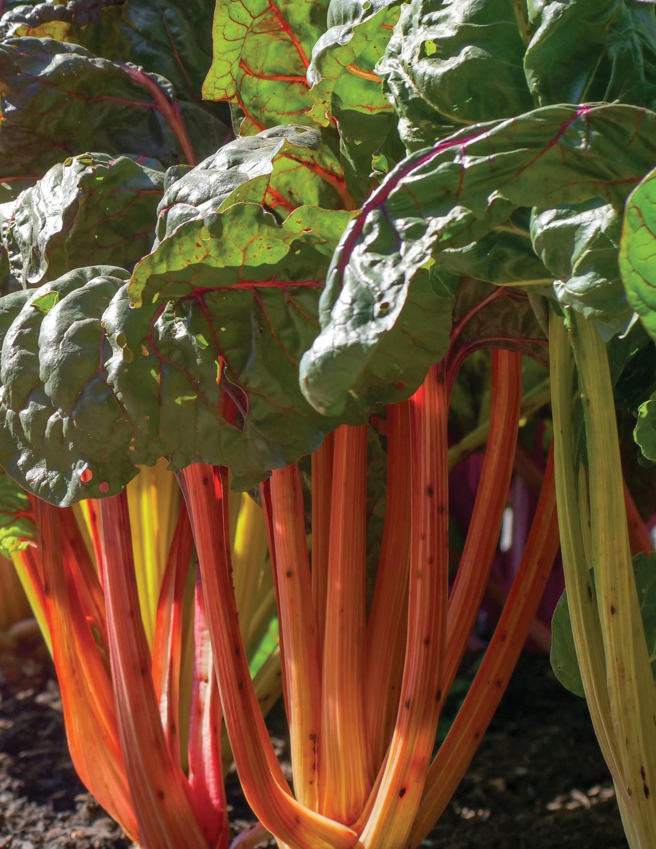
There are seven working farms in Pittsfield according to Berkshire Grown’s 2024 Guide to Local Food and Farms: Bittersweet Farm, Brattle Farm, Flynn Farm, Forthill Farm, Hancock Shaker Village, Jaeschke’s Orchard, and ServiceNet’s Prospect Meadow Farm.
1. Bittersweet Farm
Offers a variety of fresh produce, eggs, cut straw, cut flowers, and pumpkins at their farm stand.
2. Brattle Farm
Produces vegetables and honey using organic farming methods. Grazes chickens and sheep on 17 acres of pasture, raising chemical-free eggs and lamb. They offer Tunis yarns produced from a flock of Merino sheep.
3. Flynn Farm
Grows vegetables including beets, beans, peas, greens, onions, corn, potatoes, squash, peppers, tomatoes, and pumpkins. They also sell mums, sunflowers, raspberries, and maple syrup.
4. Forthill Farm
Grows vegetables including sweet corn, tomatoes, winter squash, melons and berries. They sell flowers, mums, corn stalks and offer visitors the experience of picking their own. They sell fresh-cut greens and herbs on request. In the winter they sell Christmas trees and decorated wreaths. They raise eggs, grass-fed Angus beef and pasture-raised heritage pork.
5. Hancock Shaker Village
This historic site operates a working farm that raises heritage breeds of livestock and cultivates heirloom vegetables. Visitors can experience traditional farming practices and purchase farm products during their visit.
6. Jaeschke’s Orchard
Offers apples, plums, pears, corn, vegetables, and fresh cider in addition to greenhouse flowers, potted plants, annuals, and Christmas trees.
7. ServiceNet’s Prospect Meadow Farm
Provides vocational training through farming activities. They produce shiitake mushrooms, vegetables, and eggs, and offer a 19-week CSA program.
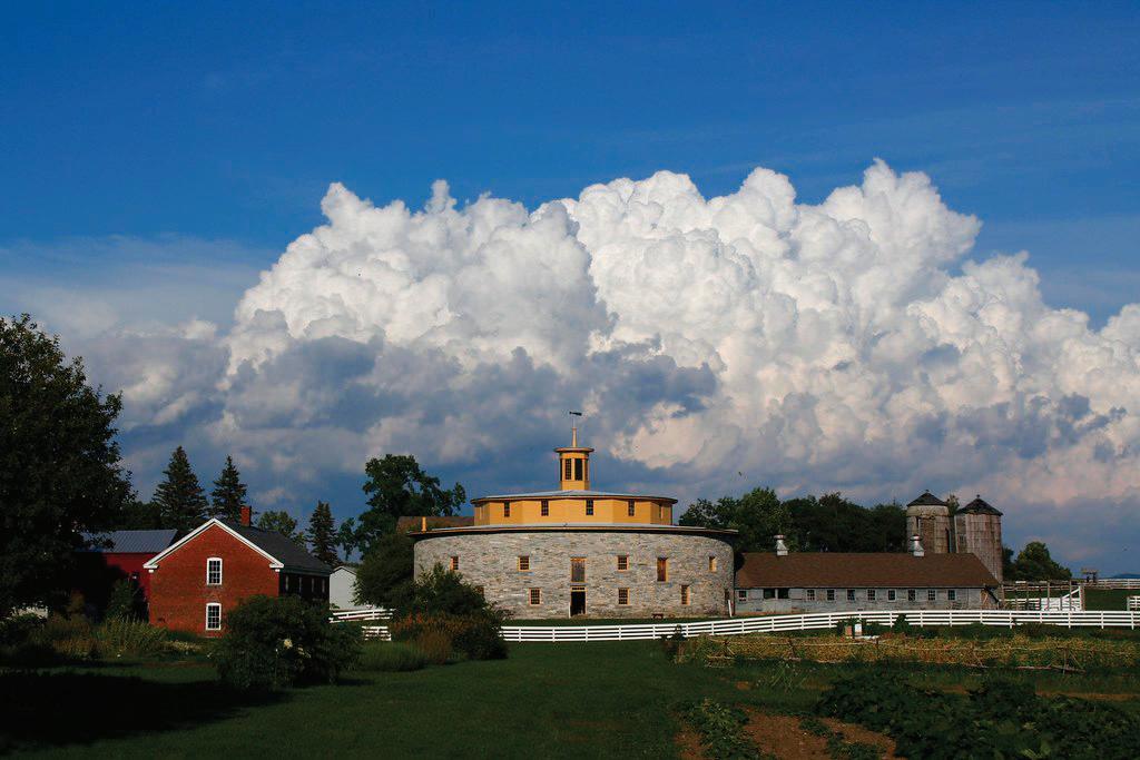
Community Spotlight: The Hancock Shaker Village
Pittsfield’s Hancock Shaker Village operates a living history museum that showcases the agricultural and communal lifestyle of the Shakers. Visitors can explore historic buildings, watch demonstrations of traditional farming techniques, and interact with farm animals. The village also operates a working farm with heirloom vegetable gardens and livestock, offering seasonal events like baby animal days and farm-to-table dinners.
“Hancock Shaker Village- Pittsfield” by MA Office of Travel & Tourism is licensed under CC BY-ND 2.0.
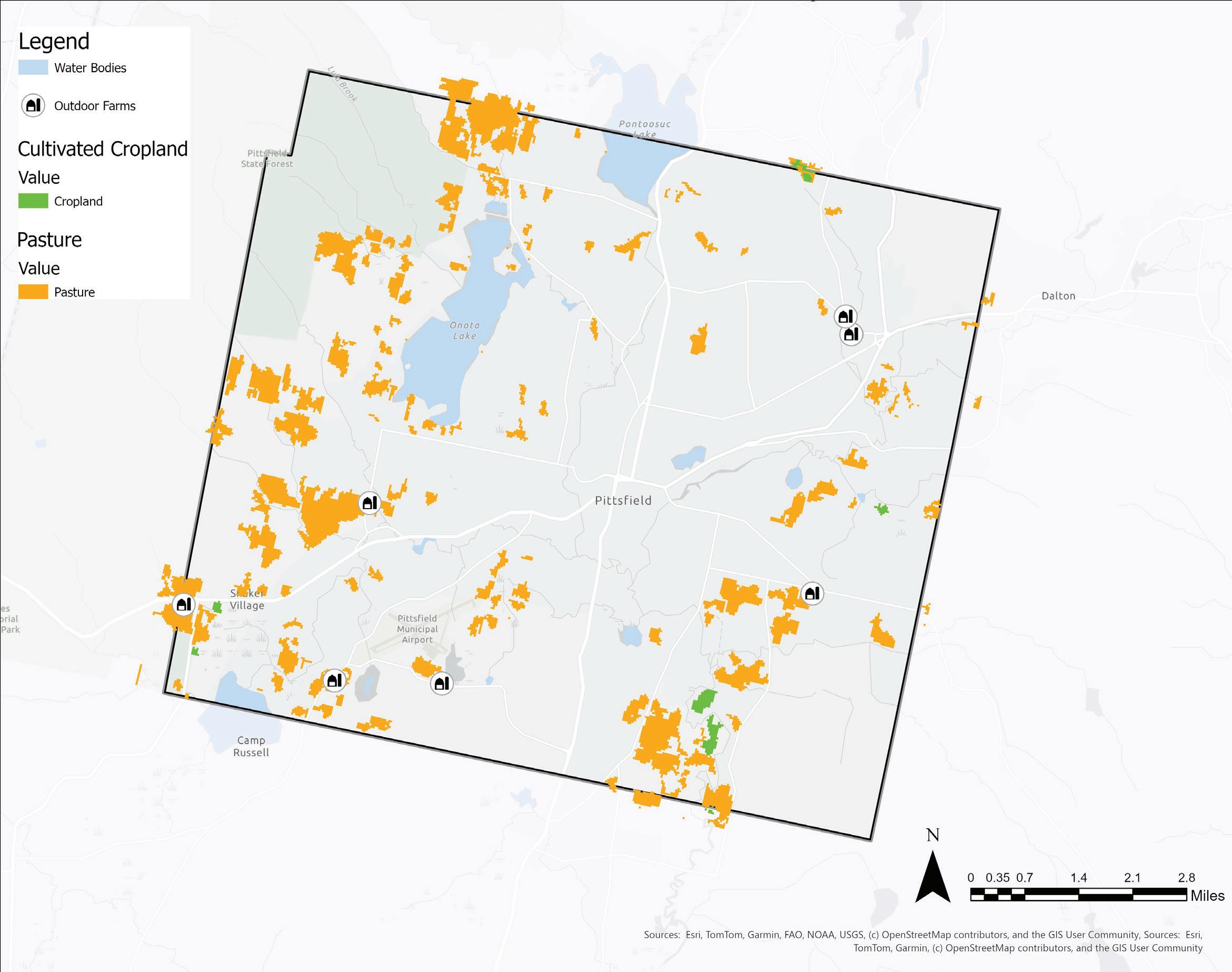
The locations of existing farms in Pittsfield lie several miles out from the city center. The majority of farmland is Pittsfield appears to be used as pasture, with a concentrated area of cropland in the southeast.
REGIONAL CROP INVENTORY
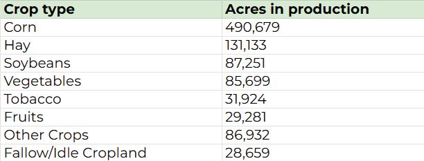
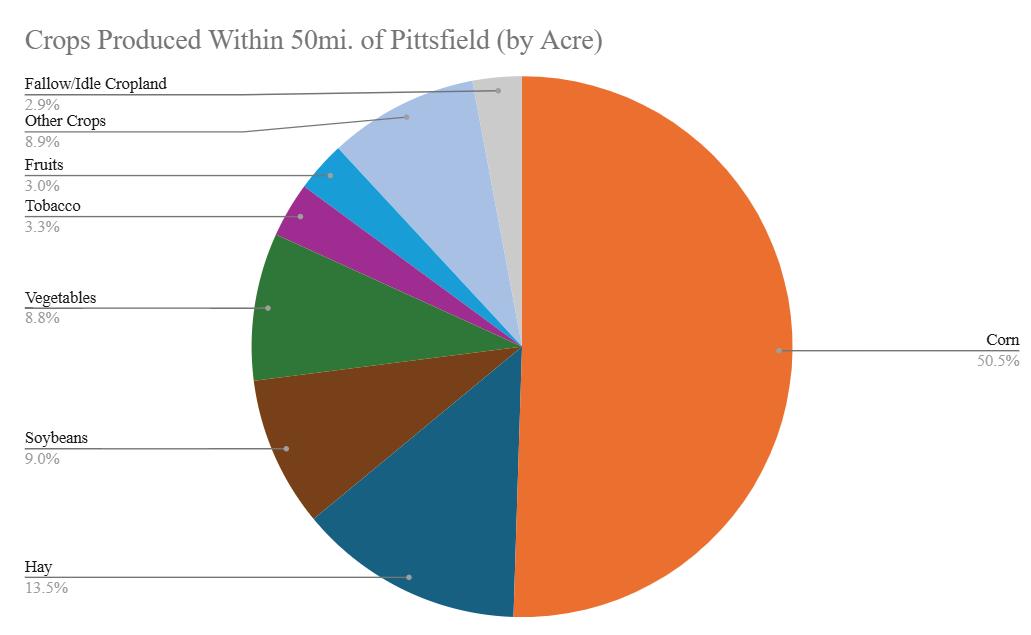
The majority of cropland in a 50 mile radius around Pittsfield is used for corn (50.5%) and hay (13.5%). While hay and corn production often does not directly feed people, it is used to feed livestock and is therefore an essential component of the food system. Fruit and vegetable cultivation combined accounts for 11.8% of cropland usage, significantly higher than the national average of 2% (USDA).
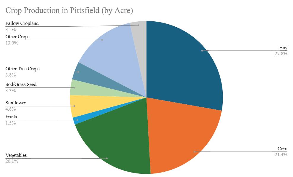
PITTSFIELD CROP INVENTORY
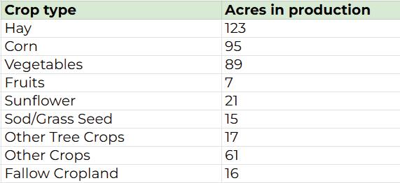
Within Pittsfield, corn and hay cultivation remain prominent (21.4% and 27.8% respectively), but a large amount of land is dedicated to vegetable production (20.1%). Fruit cultivation is minimal, with only 6.7 acres (1.5% of cropland). Fruit and tree crop cultivation together account for 5.3% of cropland usage.
Source
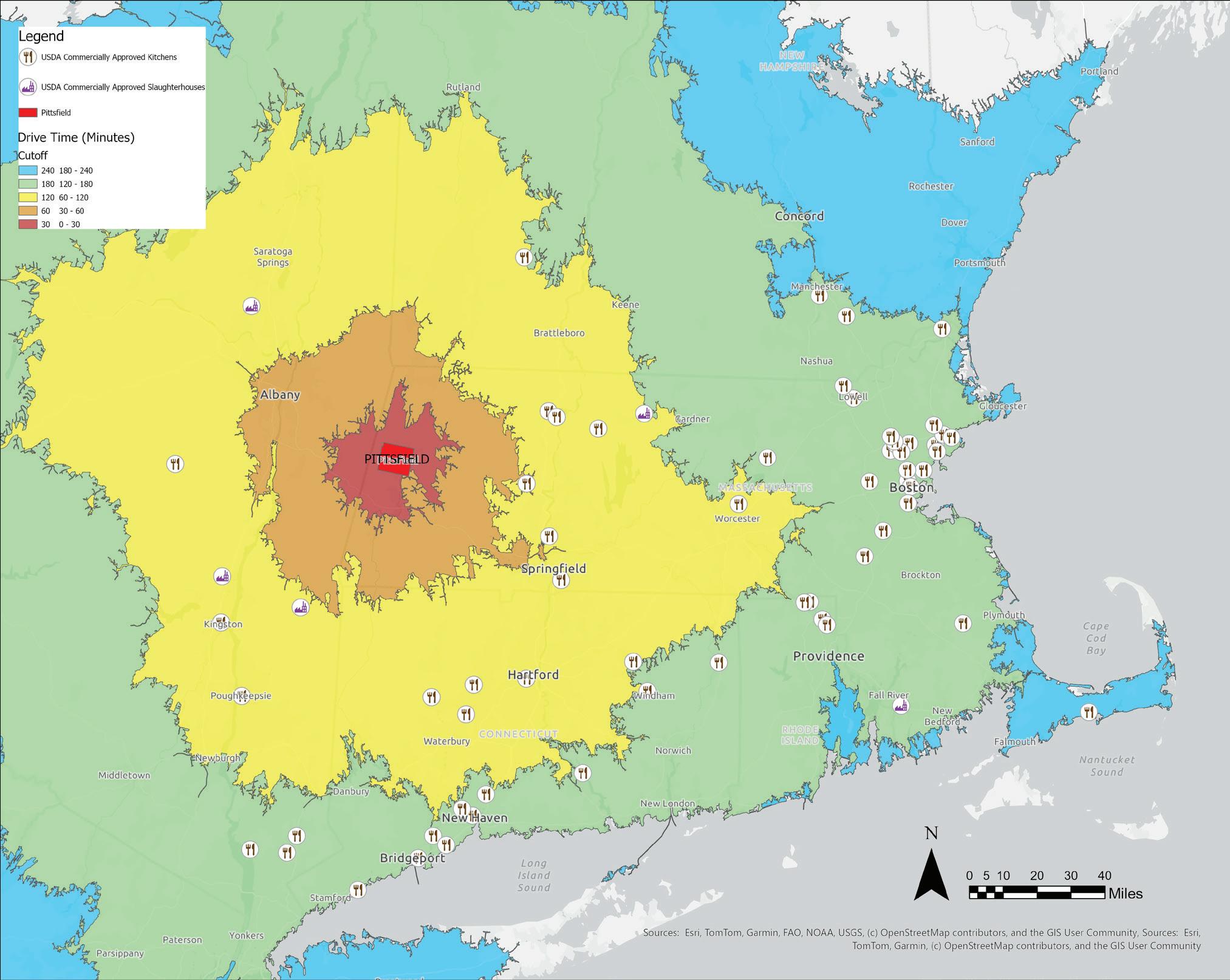
FOOD PROCESSING SITES | DISTANCE FROM PITTSFIELD
A variety of crops are produced in Pittsfield, but farmers and food makers must travel long distances to access legally approved processing facilities. The nearest slaughterhouse, Josef Meiller Slaughter House, is about 70 minutes away, while the closest USDA-approved commercial kitchen, at Haydenville Congregational Church, is a 50 minute drive. No commercially approved facilities exist within a 30 minute drive, and only one kitchen is available within an hour.
According to interviews conducted by Sustainable Berkshires, access to slaughterhouse facilities is not only obstructed by distance, but also by a year or longer wait list time.
Restricted access to processing facilities results in higher logistical costs; a viability constraint for small food businesses in Pittsfield.
RECOMMENDATIONS | FARM VIABILITY
PRESERVE EXISTING FARMLAND
1. Engage with landowners and farmers directly to share information about farmland conservation resources and benefits (e.g. APRs, Conservation Restrictions, and Chapter 61).
2. Explore partnerships between the City of Pittsfield and local land trusts to facilitate the sale of farmland into land trust ownership and permanent protection as opportunities arise.
3. Engage with realtor organizations in the Berkshires to educate local realtors around farmland conservation tools and succession planning options.
4. Maintain awareness of Chapter 61 parcels so that when they are up for sale, the City of Pittsfield can exercise the right of first refusal.
INVESTIGATE VIABILITY FOR AN AGGREGATE PROCESSING FACILITY IN PITTSFIELD
Farmers need reliable markets to sell their products at scale, but this requires large-scale production. Similarly, small farmers face high investment costs to process their own products. These costs are then passed on to consumers, increasing the price of local produce and pushing farmers into niche markets. A cooperative focused solely on market access would not address the high costs of production, making it an incomplete solution for small farm viability.
An aggregate processing facility that manufactures products using crops from multiple small farms could help lower production costs. This is especially promising for livestock farmers, whose meats could be processed into ground products at scale. Centralizing processing infrastructure and making it accessible to small farmers would reduce costs that would otherwise be prohibitive.
Pittsfield, centrally located in the Berkshires, might be well-positioned to support an aggregate processing facility. The city is home to several existing meat processing businesses, such as Mazzeo’s and Whorle’s. A partnership between an agricultural cooperative and an established processor could lower costs for Berkshire County farmers while also benefiting Pittsfield businesses.
However, the demand for an aggregate processing facility is unknown. The city should consider commissioning a study investigating the financial viability of an aggregate processing facility in Pittsfield.
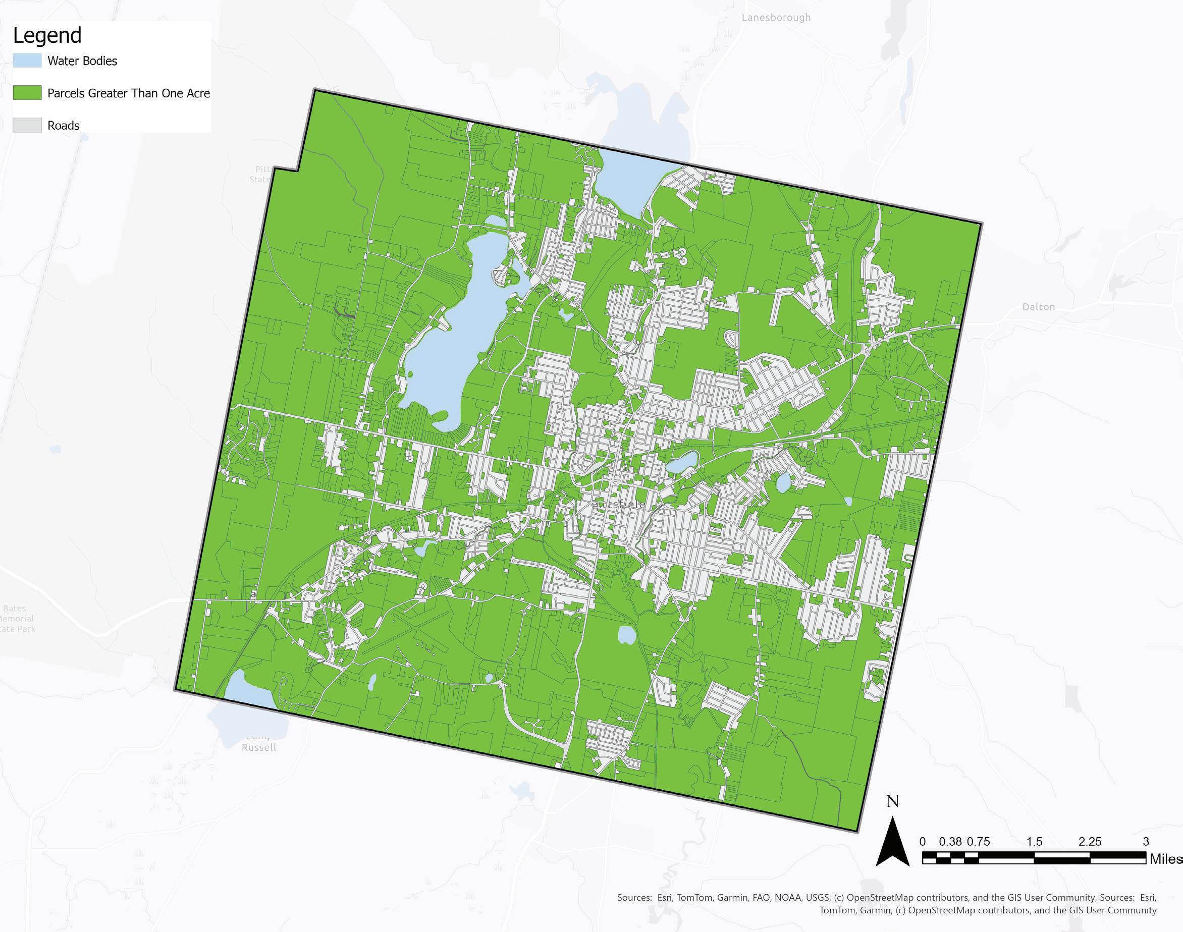
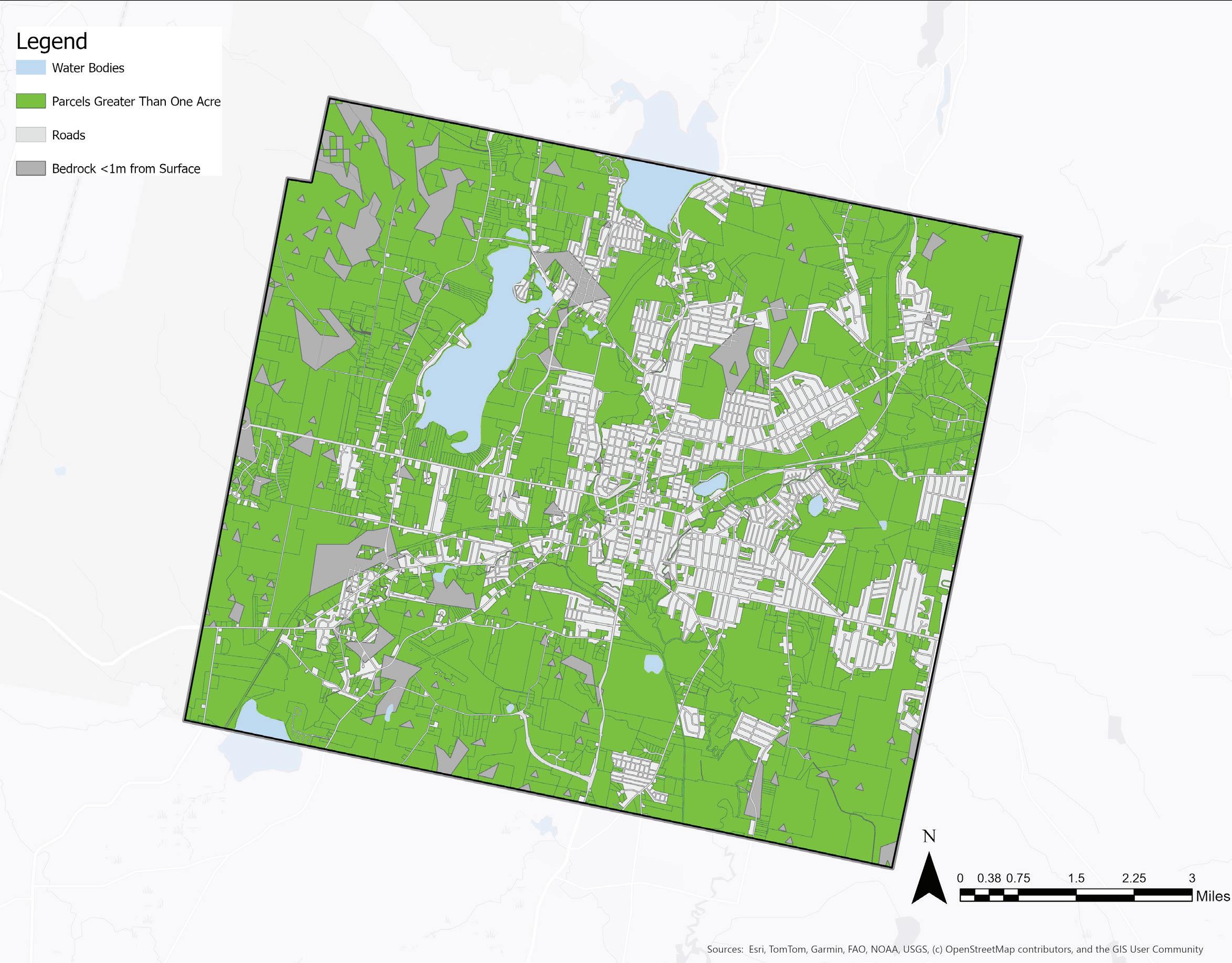
Parcels Greater Than One Acre
FARMABLE LAND IN PITTSFIELD
Identifying parcels of conventionally farmable land (suitable for tillage) greater than one acre in Pittsfield involves seven criteria: clear area (no trees or buildings), prime agricultural soils (NRCS), bedrock greater than one meter away from the surface, slopes less than 5%, not on NHESP rare species habitat, not on wetlands, and not on EPA superfund sites. The following inventory displays areas in the city that are suitable or not suitable for farming based on each of the seven criteria.
In Pittsfield, parcel sizes tend to be smaller than one acre in the center of the city and along main roadways. A parcel size greater than one acre, is the first criteria to consider when considering parcels for urban farming. Farming requires fixed cost investments which would not be worthwhile on small parcels. Therefore, parcels smaller than one acre may be considered for gardening, but farms should only be sited on parcels greater than one acre.
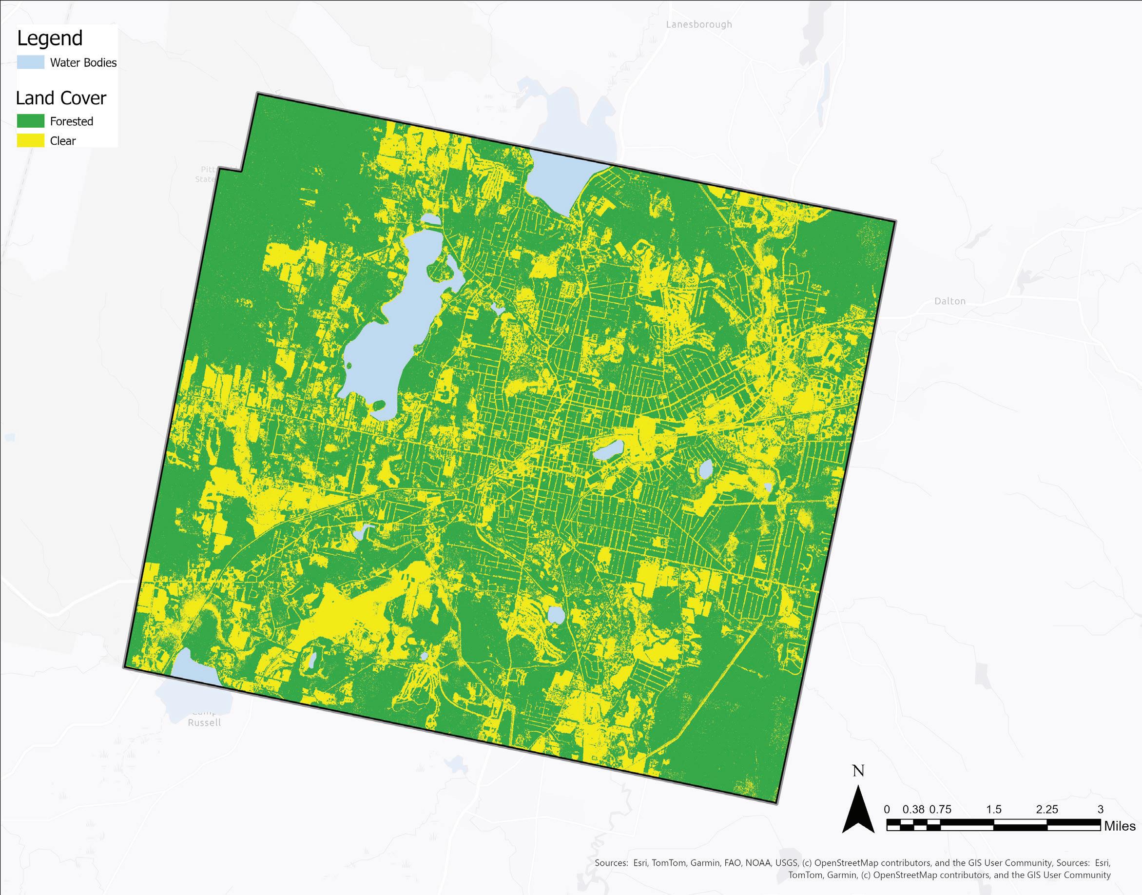
Clear Areas in Parcels >1 Acre
This map shows clear area in yellow and forested areas in green. Parcels less than one acre in area are also shown in green. Tree canopy is absent in much of Pittsfield’s city center, resulting in high surface temperatures as shown on page 47. While the lack of tree canopy and consequent high surface temperatures are not beneficial to residents’ quality of life, some clear areas could be considered for urban agriculture, adding valuable green space to otherwise impervious urban areas. The shade and
root systems from trees restrict the needs of food crops that require full sun and tillage. While some perennial food crops could be cultivated alongside trees, clear parcels should be prioritized for establishing urban farms in Pittsfield.
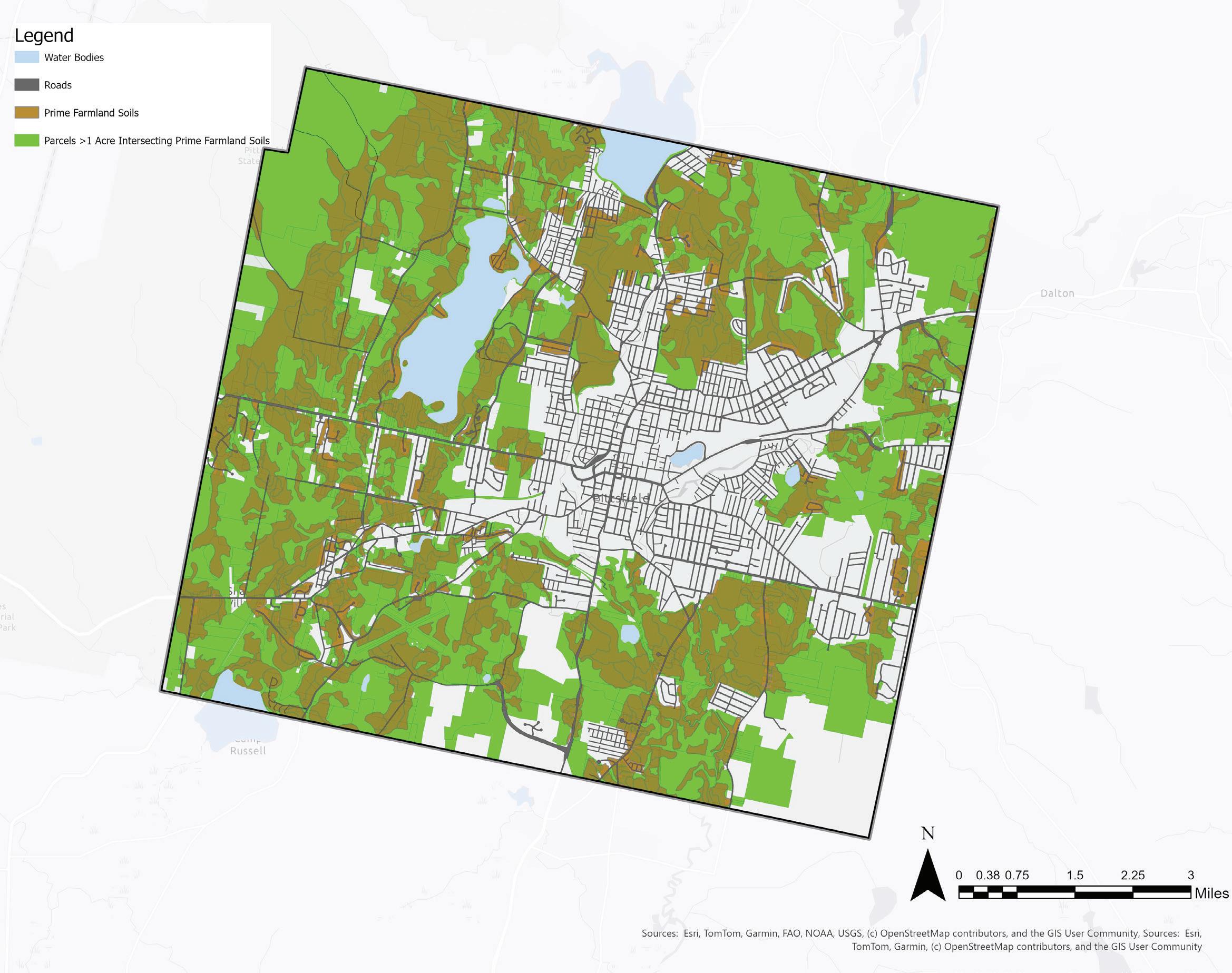
Prime Farmland Soils & Parcels >1 Acre
This map shows parcels greater than one acre and areas of prime farmland soils. There are significant areas of prime farmland soils outside of the city center. Parcels containing prime farmland soils should be considered for urban agriculture, especially those that exceed 1 acre of contiguous prime soil area.
<1 Meter Depth to Bedrock & Parcels >1 Acre
This map shows parcels greater than one acre (in green) and bedrock less than one meter from the surface (in grey). There are some areas where bedrock is close to the soil surface, notably adjacent to the Taconic range and inside Spring Side Park. Conventional farming in areas where bedrock is less than one meter from the surface is constrained by soil volume, water-holding capacity (causing either poor or excessive drainage), and also risks groundwater contamination from agricultural chemicals (NRCS). Therefore, farming should be avoided in areas where bedrock lies less than one mater from the surface.
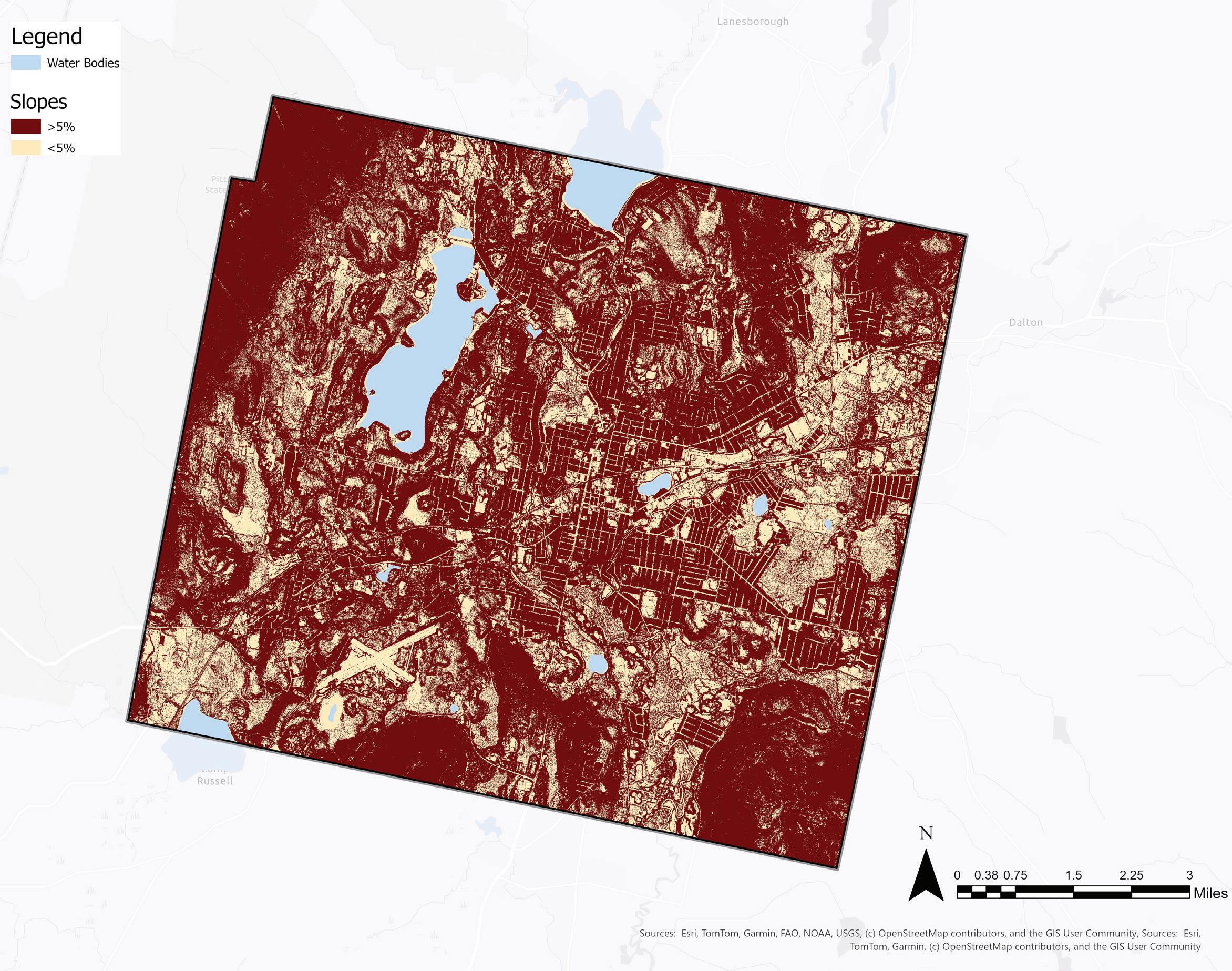
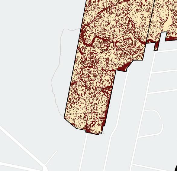
<5% Slope in Parcels >1 Acre
This map shows slopes greater than 5% in red slopes less than 5% in beige. Parcels less than one acre in area are also colored red, excluding them from this analysis. Pittsfield is known for its proximity to mountains to the west and south east, but there appear to be flat areas with a <5% slope in much of the city, particularly in the east. Areas with slopes greater than 5% are not suitable for conventional farming due to increased erosion (due to wind and water) and runoff (of stormwater and chemicals), but may be suitable for other types of agriculture that
minimize erosion and runoff such as agroforestry or silvopasture. While there may be opportunities to practice these types of agriculture in Pittsfield, flat areas suitable for conventional food production should be prioritized for establishing urban farms in Pittsfield.
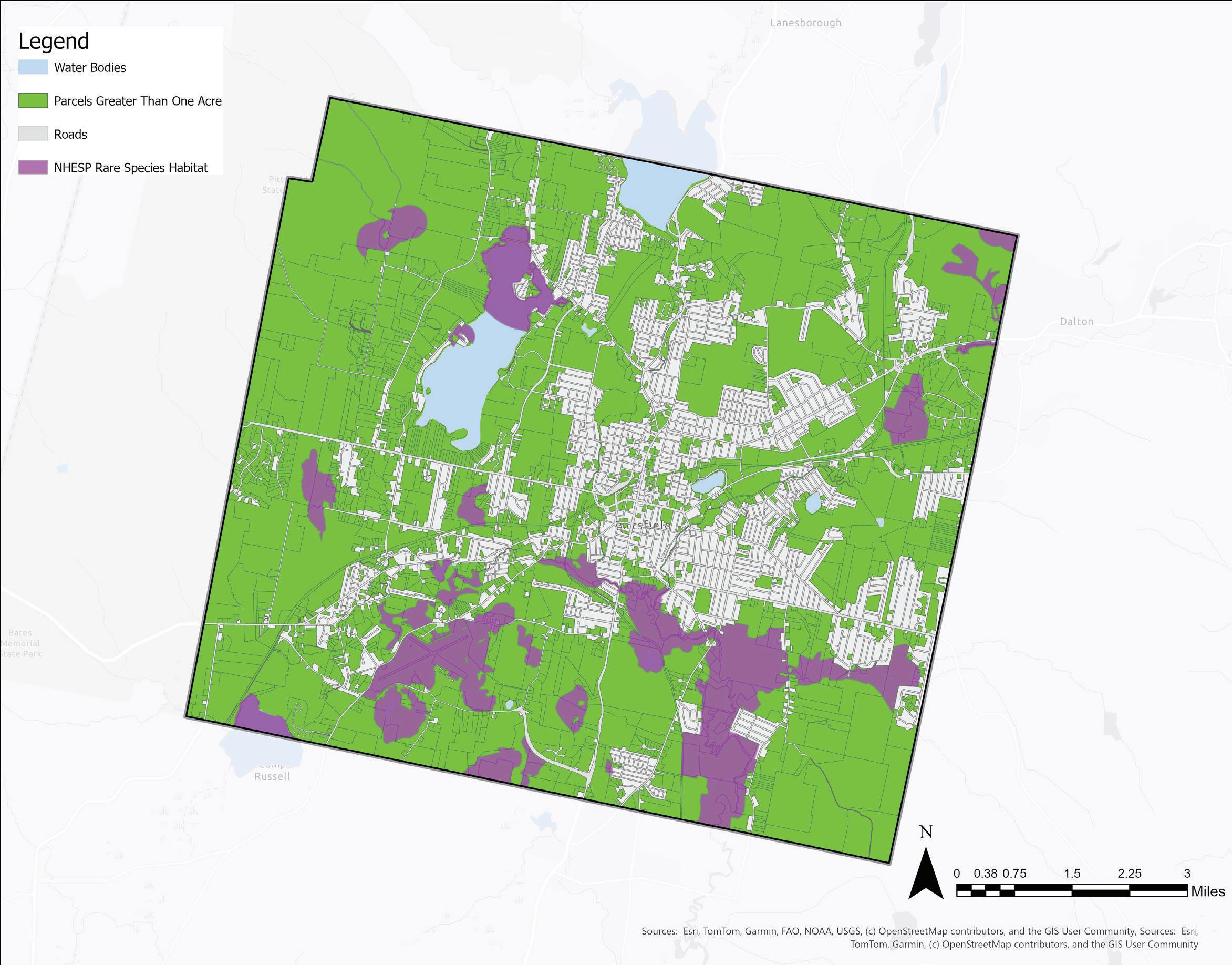
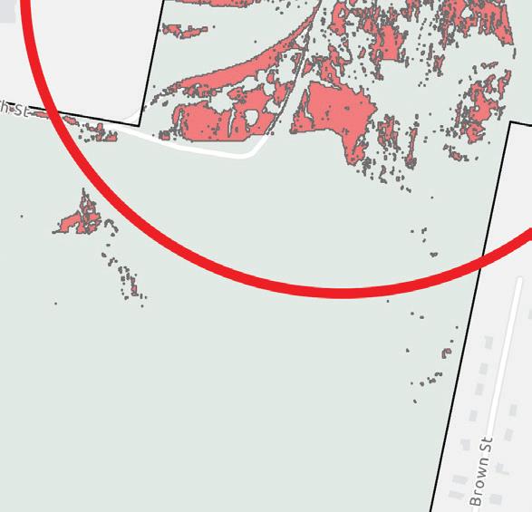
NHESP Habitats in Pittsfield & Parcels >1 Acre
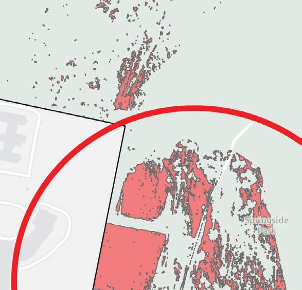
This map shows parcels greater than one acre (in green) and NHESP rare species habitat (in purple). Rare species habitat exists in the northern portion of Onota lake, around the airport in the southwest, and around Sykes mountain in the southeast. Farming could imperil fragile populations of plants or animals and should therefore be avoided on areas of rare species habitat.
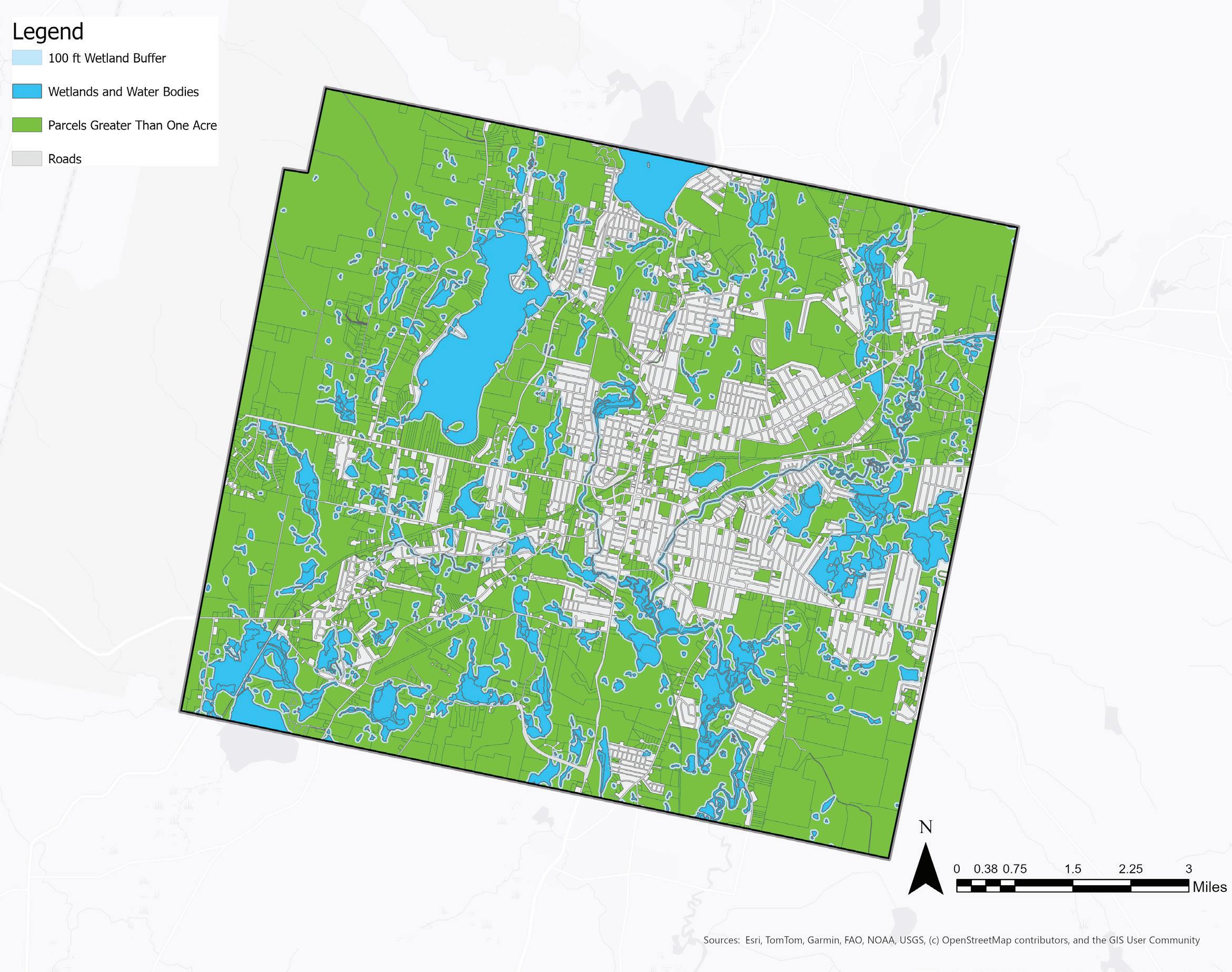
Wetlands and Water Bodies & Parcels >1 Acre
This map shows parcels greater then one acre (in green) and wetlands and water bodies with a 100 foot buffer (in blue and light blue, respectively). There is a significant area occupied by water bodies and wetlands in Pittsfield. Parcels intersecting wetlands or wetland buffers may be considered for farming, but farming should be avoided within 100 feet of wetland areas.
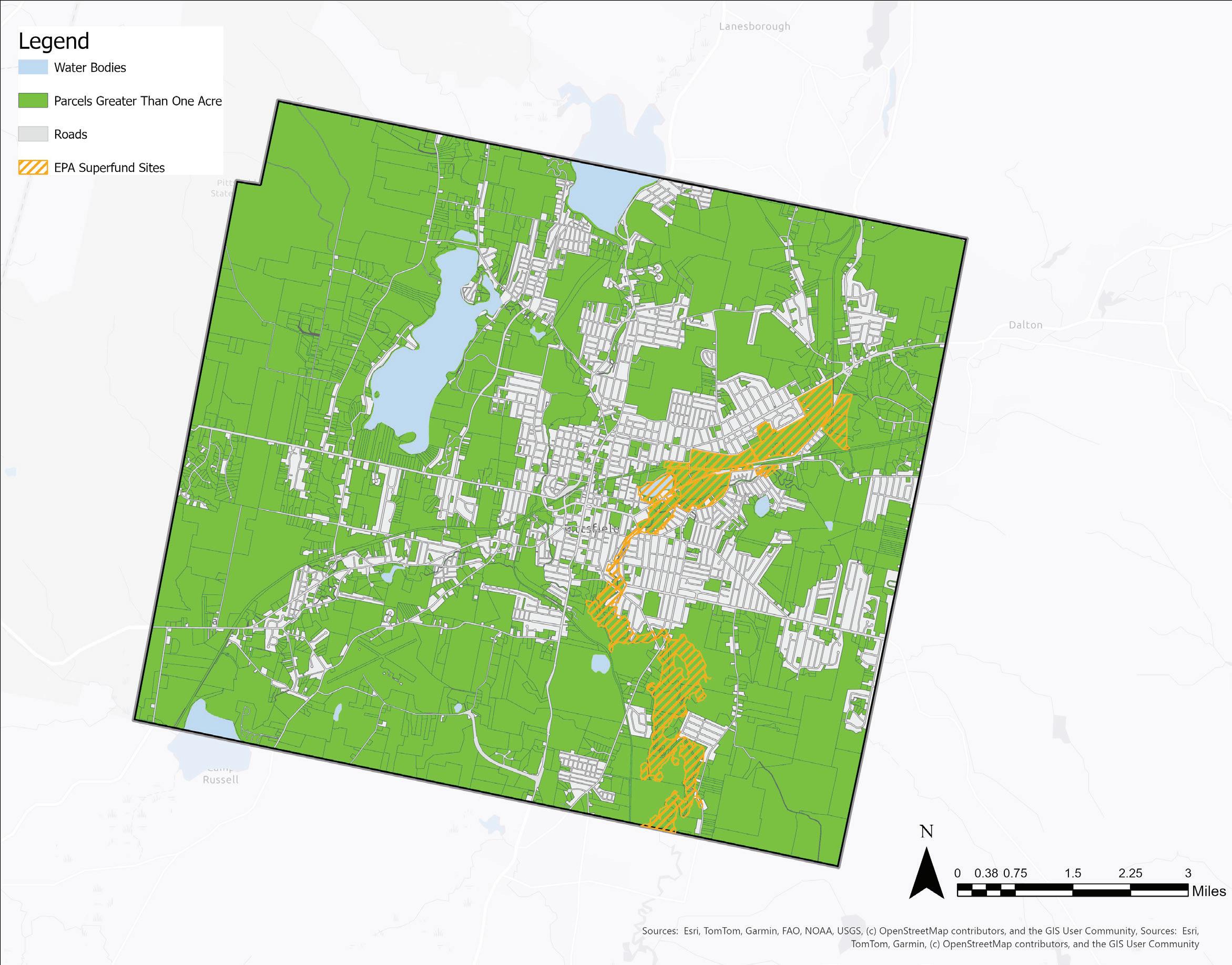
Contaminated Sites & Parcels >1 Acre
There are contaminated soils around the Housatonic river associated with past plastics manufacturing and the improper disposal of industrial chemicals. This map shows parcels greater than one acre and EPA superfund sites (in yellow). Parcels on EPA superfund sites should not be considered for farming due to dangerous exposure to chemicals in the soil when the earth is moved, as well as the risk of plants uptaking chemicals when rooted in contaminated soils.
Parcels >1 Acre Intersecting with All Criteria
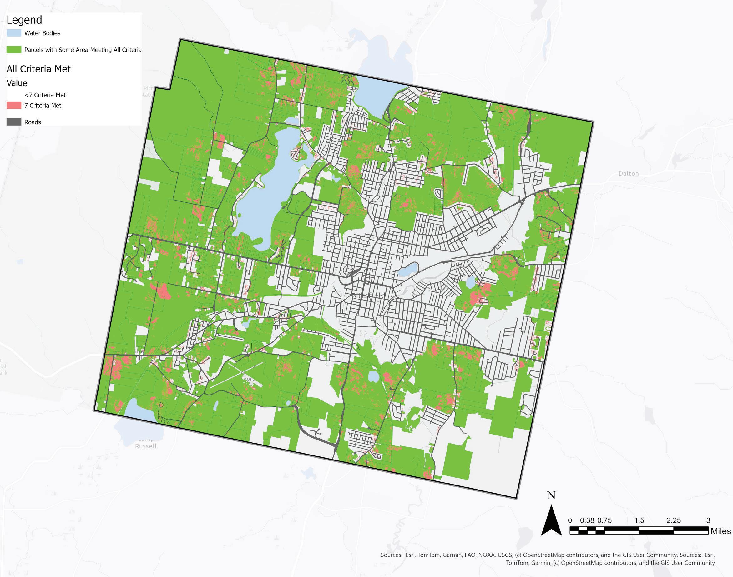
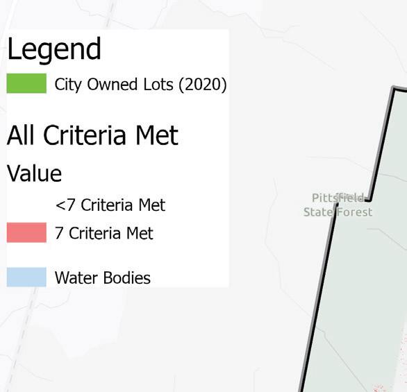
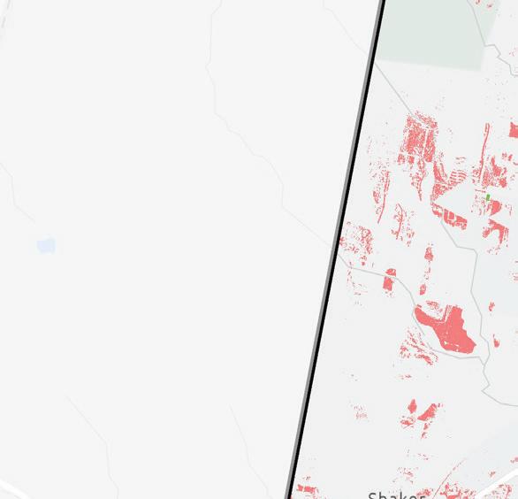
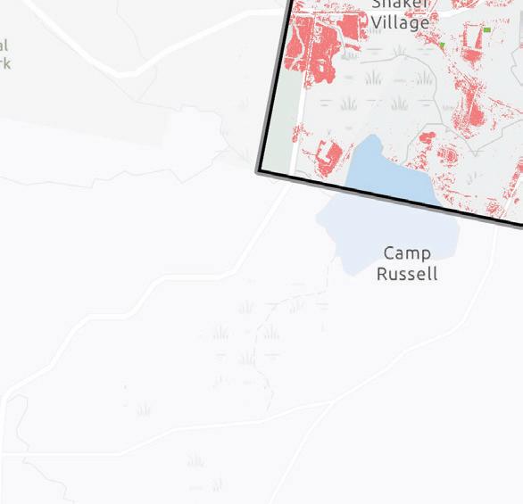
This map shows all parcels in Pittsfield (in green) that have some area where all seven urban farming criteria are met (in red). Areas with less than seven farming criteria are transparent. The parcels shown may not be optimal for farming since even a very small area of overlap with farmable land registers the parcel. Further analysis is needed to evaluate the cultivation potential of each site.
There appear to be clusters of farmable land throughout Pittsfield, excluding parcels near the center or the city. These clusters of farmable land might be considered for cultivation as opportunities arise.
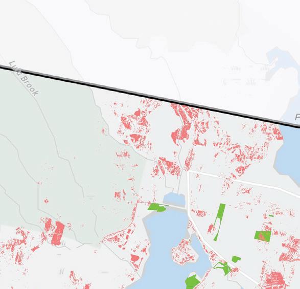
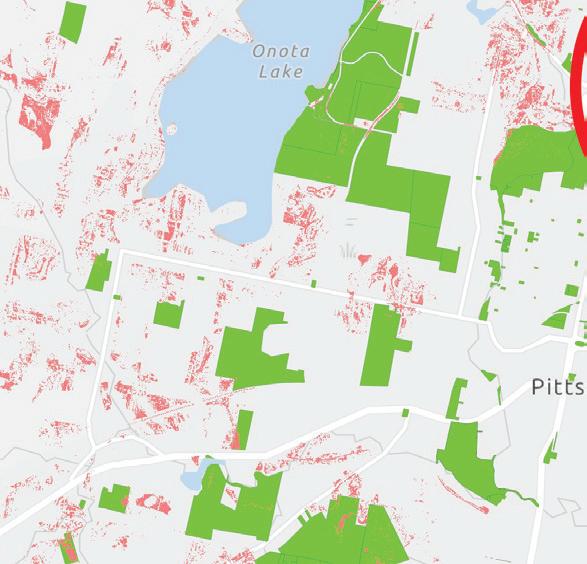
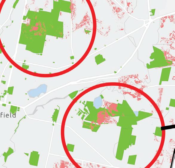
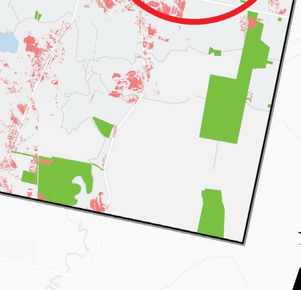
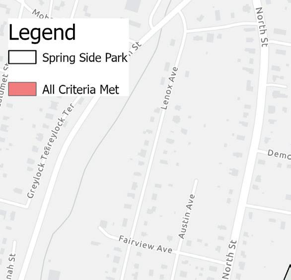
City-Owned Land Suitable for Farming
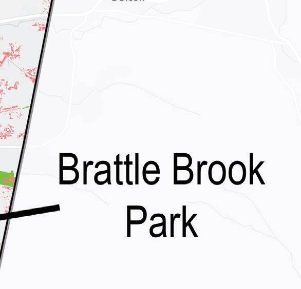
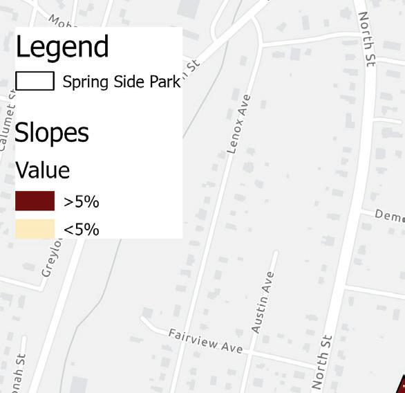
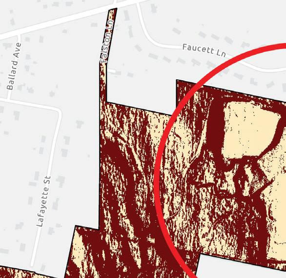
While there may be opportunities to explore for urban farming on parcels not owned by the city, the city of Pittsfield has the authority to establish urban farms on municipal land. This map shows cityowned parcels intersecting with all seven urban farming criteria. The largest clusters (approximately >1 acre of area) appear on Brattle Brook Park and Spring Side Park.
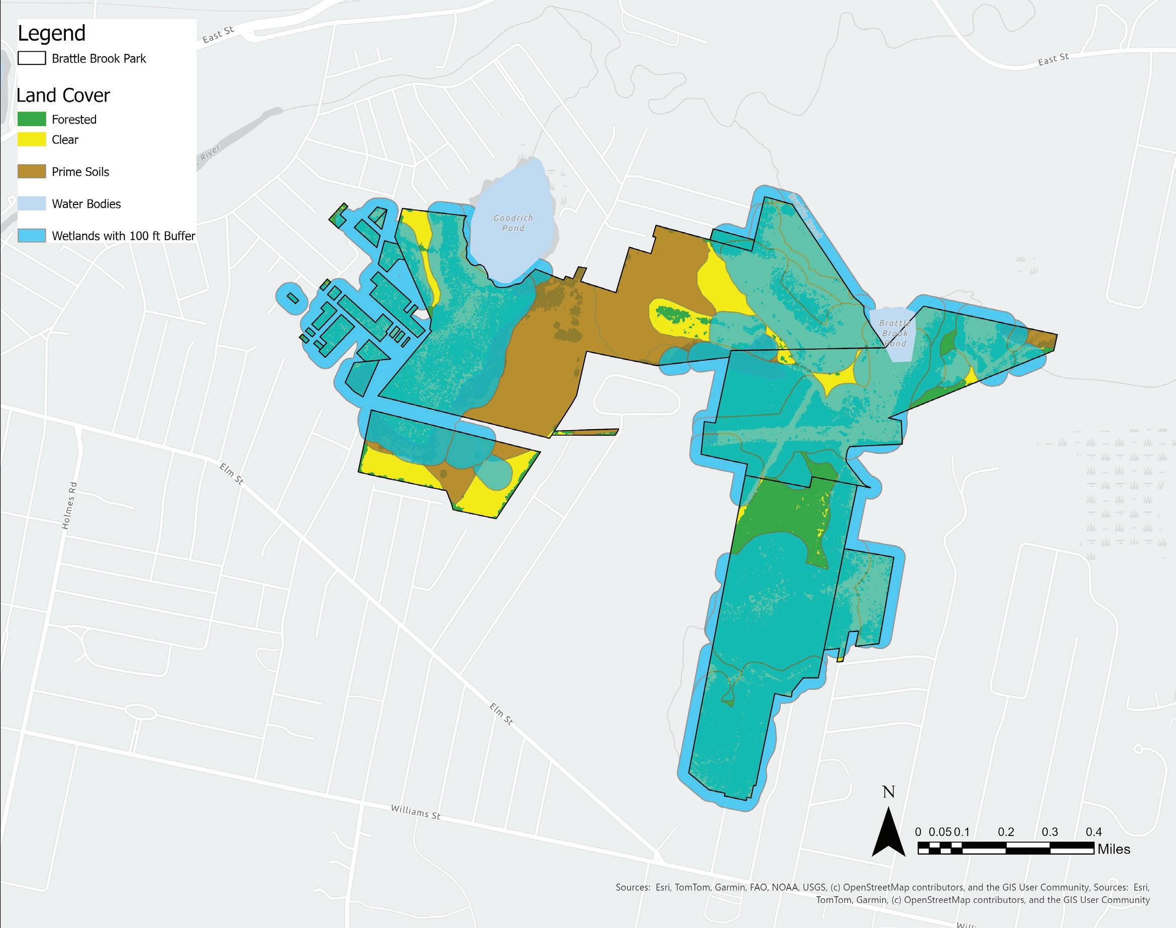
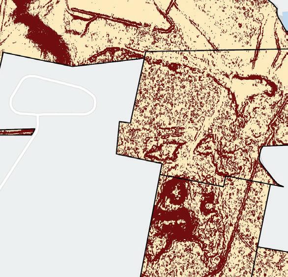
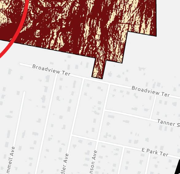
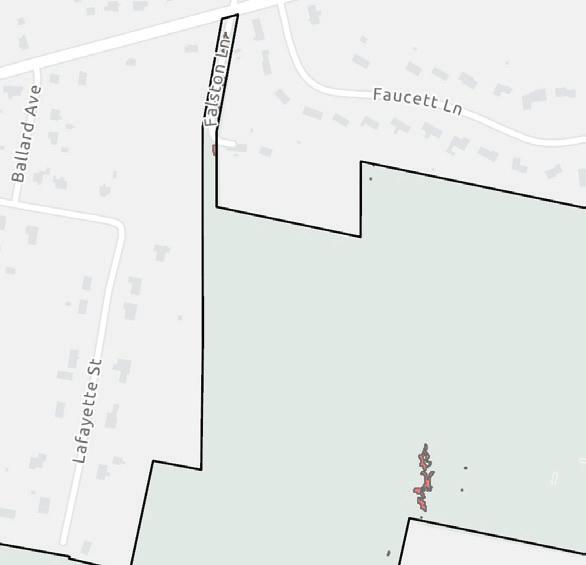
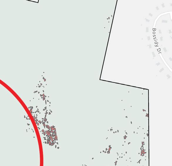
Brattle Brook Park | Ecology
Brattle Brook Park is a 178 acre parcel historically used as farmland. People enjoy hiking and watching wildlife in the park. There is a soccer field at the park.
Swamps exist in the northwest and eastern areas of the park alongside patches of shallow marsh meadows. The site contains a diversity of wet and dry, alkaline and acidic, and nutrient-poor and nutrient-rich soil types producing a diversity of habitat. Mosaic patterns of grassland and forested areas reflecting the park’s past agricultural use may further contribute to supporting many habitat types on the site. There are no NHESP priority habitats of
rare species on the site.
The park’s primary purpose is for conservation, and it is currently municipally owned and protected in perpetuity under Article 97. The park has received funding from several grants, including the Land and Water Conservation fund and State Self-Help fund. Restoring farmland on conserved lands could be controversial; thorough outreach to Pittsfield residents should be done to gauge community support.
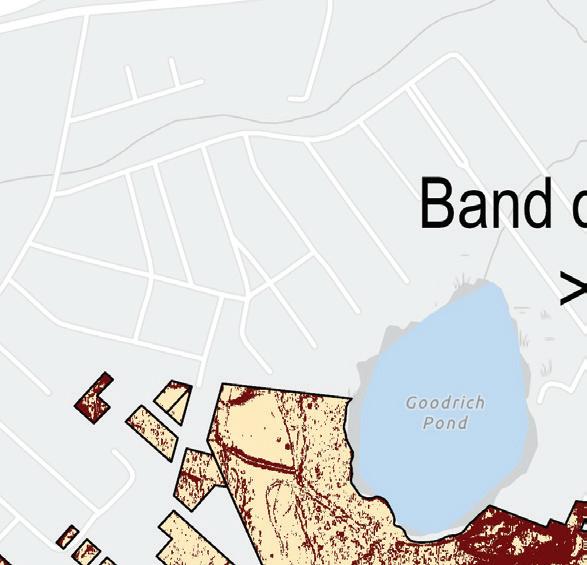
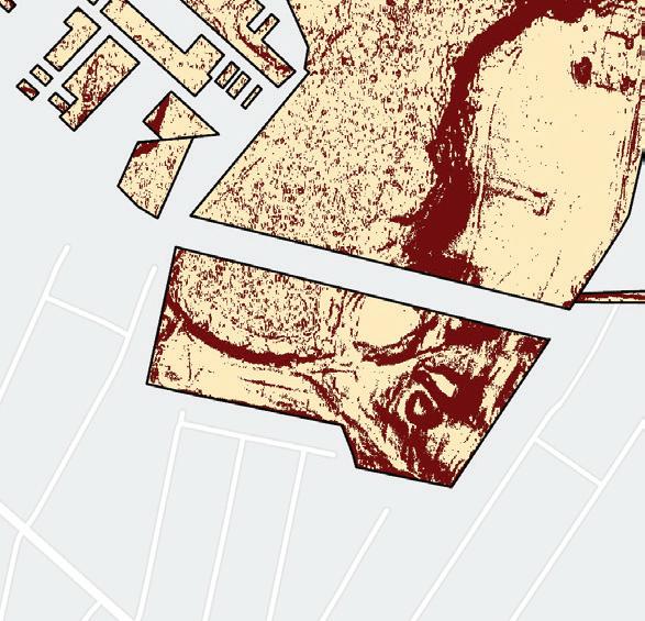
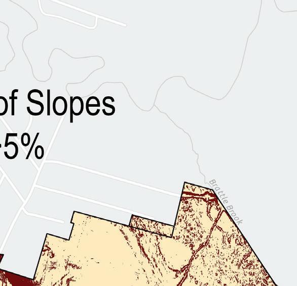
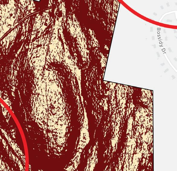
Brattle Brook Park | Slopes
Slopes less than 5% are considered optimal for farming crops. Flat land reduces soil erosion and is more accessible to farm machinery. Slopes in the park are mostly less than 5%, with consistently flat area lying in the center. There is a band of >5% slopes in the center which separates flat areas, meaning multiple fields conforming to the landform would be optimal for conventional agriculture on the site.
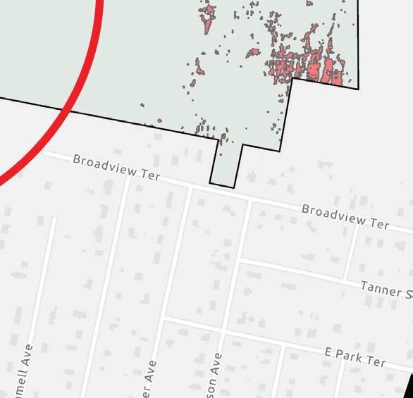
Cultivation Opportunities at Brattle Brook Parks
The north-central tract of grassland (>50 acres) in the park meets all seven criteria for urban farming. Other parts of the park are primarily swamplands, but dry forest could be environmentally suitable for forest farming: there is a stand of moist-cool northern hardwood forest in the northeast corner of the park east of Brattle Pond. Shady, cool, and moist environments are suitable for mushroom cultivation.
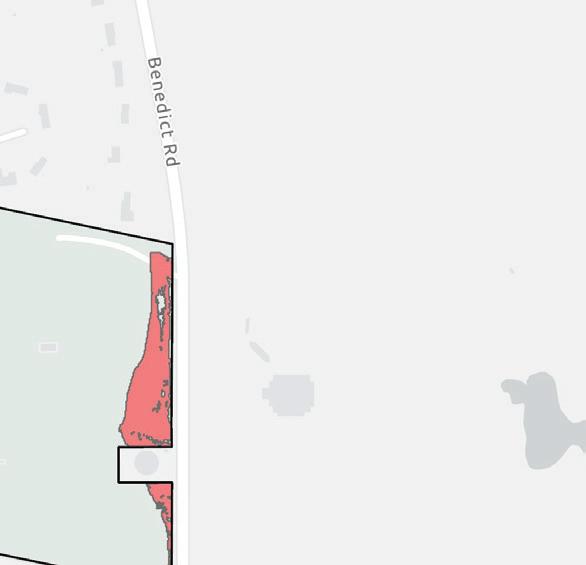
Spring Side Park | Analysis
Springside Park is the largest city-owned parcel in Pittsfield at 237 acres. Residents use the park for hiking, sports, and to visit attractions like the Herbert Arboretum and the Springside House located on the southwest side of the site. There is an American chestnut seed orchard operated by the American Chestnut Foundation containing 3,000 seedlings (Hill County Observer).
Isolated pockets of forested wetlands exist, particularly on the southwestern side. Bedrock lies one meter or less down from the surface in the center of the park, so tilled cropland could not be sited there.
There is a mosaic of grassland and forests made up of northern hardwoods and conifers, including
sugar maple, American beech, yellow birch, eastern hemlock, eastern white pine, and red oak. Some sections of the park may have been historically used as farmland. There are no NHESP priority habitats of rare species on the site, reducing the chance of disturbing priority habitat through farmland restoration. If the city pursues farmland restoration, ecological surveys evaluating habitat value should be conducted.
The park’s primary purpose is for recreation and conservation. Community input should be allowed before converting any public land to agricultural uses, and any farm operations on site could be made open for public involvement, perhaps through a community farming model.
Spring Side Park Slopes | Analysis
Slopes in the park are mostly greater than 5%, but there are some flatter areas in the central and eastern parts of the park circled in red. The flat, central area located on prime agricultural soils appears to be optimal for urban farming, but may need to be regraded to create a consistently flat surface.
Cultivation Opportunities at Spring Side Park
The center of the park meets all seven criteria for urban farming. With some investment, the city could establish sizable tracts of cropland in cleared areas that were farmed in the past. In forested areas, there may be opportunities to practice forest farming, silvopasture, or agroforestry. Community input should be allowed before converting any public land into agricultural use.
Case Study:
D-Town Farm and Improving Land Access for Farmers
D-Town Farm, located in Detroit, Michigan, is a notable example of how converting city-owned land into productive farmland can address one of the most significant challenges facing urban farmers: access to affordable, reliable land. Managed by the Detroit Black Community Food Security Network (DBCFSN), the farm operates on 7 acres of city-owned land, leased from the City of Detroit. By using publicly owned, vacant land for farming, D-Town Farm provides affordable land access to local farmers, demonstrating how cities can leverage their resources to support urban agriculture while also giving residents the opportunity to develop skills and have ownership over local food production.
“Land access is one of the biggest barriers to urban farming. Publicly owned land is a vital resource that should be put to work feeding our community.”
-Malik Yakini, Executive Director of DBCFSN
Community Spotlight: Food Bank Farms, Hadley, MA
The Food Bank of Western Massachusetts has a unique program where the food procured is not exclusively dependent on donated food from retailers, state and federal governments. It is also supplemented by food from two partner Food Bank Farms. The Food Bank farms are an investment in local farmland for farmers to strengthen the local farm economy while also providing a reliable source of healthy, organic food for those who are most in need. Local farmers who grow organic vegetables for the community are contracted and in lieu of cash rents for access to the land, the farmers distribute an agreed-upon share of their produce to the Food Bank, schools in highpoverty school districts, or local retail stores. The food grown on these farms is further distributed by the Food Bank of Western Massachusetts through their mobile markets, brown bag programs, and partner pantry sites. This unique model of farming is able to reduce the cost of farming for small farmers and simultaneously link local food production with food access in the state. (Food Bank of Western Massachusetts, "Food Bank Farms").
“BMe D Town Farm” by Knight Foundation is licensed under CC BY-SA 2.0.
INDOOR FARMING POTENTIAL
Indoor agricultural methods such as hydroponic, aeroponic, or vertical farming take place in controlled environments, often indoors (Eden Green). Most indoor farming involves hydroponics; or the cultivation of plants using water-based nutrient solutions instead of soil. There are two publicly known indoor farms in Pittsfield: Berkshire Microgreens and the Berkshire House of Corrections Aquaponics Lab.
EXISTING INDOOR FARMS IN PITTSFIELD
There are currently two operating indoor farming operations in Pittsfield:
Berkshire Microgreens
Berkshire Microgreens is a privately owned company that grows microgreens; young, edible seedlings harvested shortly after their first leaves develop. The offerings include broccoli, sunflower, pea, and radish seedlings.
Berkshire House of Corrections Aquaponics Lab
The aquaponics lab at the Berkshire House of corrections is owned by the Berkshire County Sheriff’s Office. Aquaponics is a food production system that synergizes aquaculture (raising fish) with hydroponics. The aim is to reduce inputs by substituting fertilizers with fish waste.
Indoor Food Production Potential | Industrial Parcels
Pittsfield has 126 parcels and 220 structures designated under use codes 400 and 401 (buildings for manufacturing operations and warehouses for manufactured products, respectively). It is unknown how many are operational or vacant. These structures may be candidates for indoor food production.
Sources: City of Pittsfield Zoning Map
Indoor Food Production Potential | Industrial Structures
The Berkshire Crossing area on Pittsfield’s eastern border has the highest concentration of industrial structures with access to roads and other existing infrastructure. A closer look identifies a high density of structures that may have potential for indoor food production as opportunities arise. Industrial properties going offline or that are at risk of demolition could be considered as candidates for this new venture.
Sources:
Community Spotlight: Seeding Solidarity Program
The Seeding Solidarity Program is a majority immigrant and BIPOC-led collaborative undertaking by Woven Roots Farm and Finca Luna Búho to actualize food sovereignty in the Berkshires. Just in the last year, through door-to-door distribution, the two farms have grown and distributed 30,590 pounds of fresh vegetables throughout Berkshire County. The farms provide CSA shares on an equitable sliding scale that reflects an individual’s ability to pay for items and services with accountability to the interconnectedness of the community. This model facilitates a tangible form of wealth redistribution as the funds from shares purchased above market rate are used to support their solidarity share fund. It is one step toward dismantling the injustice of the oppressive social structure of capitalism, white supremacy, and patriarchy that results in an unjust distribution of resources.
The program centers language justice and provides bilingual communications to over 98% of Seeding Solidarity participants who are Spanish-speaking. Aside from the production and distribution of fresh, culturally relevant produce, the Seeding Solidarity Program hosts workshops, knowledge shares, community gatherings and youth agricultural education programs that allow residents to participate in defining their own food systems (Project Sonrisas).
This program is the longest running food access initiative in the Berkshires and is currently under threat due to cuts to grant funding. The program has strong support from community volunteers who ensure weekly deliveries without any paid-full time staff members yet.
Source: Woven Roots Pricing & Payment web page
RECOMMENDATIONS | URBAN FARMING
IDENTIFY CITY-OWNED PARCELS SUITABLE FOR FARMING
A spatial analysis of city-owned parcels and areas that meet all seven urban farm criteria reveals two parcels with significant farmable land: Brattle Brook Park and Spring Side Park. These parcels have constraints that will limit their potential for agriculture which may include existing use, historic use, the presence of wetlands and water bodies, forest cover and quality, rare species habitat, soil contamination, slope, depth to bedrock, and legal protections. Further site analysis is necessary before proceeding with in-ground farming.
PURSUE CULTIVATION OPPORTUNITIES IN PITTSFIELD
The city of Pittsfield and non-profit organizations may consider acquiring land that meets urban farming criteria as opportunities arise.
Restoring farmland within Brattle Brook Park and/or Spring Side Park could improve land access for beginner farmers while also creating educational, cultural, and agrotourism opportunities which could strengthen the city’s food economy.
Aside from Springside Park, other parks in the city are protected under Article 97. Conventional cultivation would require revising each site’s article 97 designation, which would be difficult to achieve. Instead, the city could investigate opportunities to align agricultural activities occurring on the parcels with established conservation goals (by supporting forest farming or agroforestry) and seek long term leases or special use agreements rather than challenging their status under Article 97.
LEASE CITY-OWNED FARMLAND TO URBAN FARMERS
To increase the supply of farmland in Pittsfield, the City could start a “land-lease” program. Pittsfield could lease tracts of farmland on city-owned parcels at a free or reduced rate to urban farmers residing in Pittsfield. Partnerships with local land trusts should be explored to make this possible. These farmers could supply fresh food to Pittsfield residents, businesses, and institutions, forming a local food economy where stakeholders are
invested in their shared community. Local nonprofits could fill a supportive and educational role, providing technical assistance and connecting farmers with markets.
EXPLORE OPPORTUNITIES FOR INDOOR FOOD PRODUCTION IN PITTSFIELD
Pittsfield’s manufacturing past has left the city with extensive industrial infrastructure, and many warehouses and manufacturing facilities that are no longer in operation. One innovative option for unused industrial structures is indoor food production. Pittsfield is home to the Berkshire Innovation Center, which could be a partner in further exploring the potential of indoor food production in Pittsfield, as well as providing the next generation the opportunity to get involved with innovative and emerging technologies around modern food production.
Indoor food production is an emerging industry, but it remains significantly more expensive than outdoor farming. The city of Pittsfield or other organizations could conduct research on the potential of indoor food production in Pittsfield as a way of strengthening the local food system with year-round production.
COMMUNITY FOOD PRODUCTION
Community and residential gardening brings food production even closer to home, and can support food sovereignty in areas that have been systematically divorced from the food system through disinvestment and discrimination. Through gardening, residents can control what food they grow and how it is incorporated into their diets or distributed to their community, while also seasonally reducing grocery bills. Residential and community gardening builds community through shared spaces, food and cultural exchanges, and knowledge-sharing that can span cultures, generations, and city blocks, building community resilience over time.
Community stakeholders have voiced interest in additional gardening opportunities in the West Side and Morningside neighborhoods to increase community ownership over food production, but have identified an existing knowledge barrier in lower-income households when it comes to the storage and preparation of fresh food.
BUILDING CONNECTIONS
Community gardening in particular can provide residents of heavily developed, impervious urban neighborhoods a space to connect with nature through food-producing plants. When residents convene in a shared space, it provides opportunities for community-building by bringing together people who might rarely interact for a common activity. Community gardens can bring together people of all ages, cultures, and abilities. Knowledge-sharing between cultures and generations can develop skills and interests in youth, while also forging deep social connections. Particularly in neighborhoods with high immigrant populations and high rates of English isolation, community gardens are an example of spaces where cultural connections can be made both within and among people of different backgrounds by sharing stories and native foods. It also allows immigrant communities to practice their own agricultural traditions.
In addition to social connections, gardening also fosters connection with the land in which food is grown. Particularly for immigrant and marginalized populations, connection to place can be difficult in urban neighborhoods with largely impervious surfaces and a history of disinvestment, especially when experiencing English isolation. Providing
spaces for gardening, whether residential or shared, allows for residents of urban neighborhoods to engage in a reciprocal relationship with natural processes, which may begin to restore a lost connection in spaces that are often viewed as the antithesis to nature. Connection with food is another benefit. Knowledge of how food is grown, where it comes from, and environmental relationships as they relate to food are steps in restoring the connection between humans and the food they eat (Pennsylvania Horticultural Society).
CLIMATE RESILIENCE
Gardening can also mitigate the impacts of climate change in urban environments as a form of green infrastructure, helping to reduce heat island effect, increase permeable surfaces which produce less runoff, and support pollinators and other wildlife. Additional benefits include improving air and soil quality, increasing plant biodiversity in urban areas, and giving gardeners control over which chemicals or fertilizers are used. Trust in community also allows for improved natural disaster response and general climate resilience (Clarke 2019).
FOSTERING FOOD SOVEREIGNTY
Gardening has helped to address food instability in the United States, notably through the Victory Garden movement during World War II (Clarke 2019). In 2025, gardening remains a powerful tool to reduce an individual’s dependence on national and global supply chains, increase fruit and vegetable intake, and empower the individual to have control over their health and nutrition. Gardening puts the decision-making power back in the hands of the gardener, allowing the individual to choose what is grown and where their food is distributed. On a community scale, gardening provides people who have been systematically marginalized and subjected to unsafe and unhealthy food policies to make decisions based on their own dietary, health, and cultural needs when it comes to food while simultaneously lowering their grocery bills. Gardening helps to de-commodify food and allows for greater food gifting within families and communities. Giving control back to individuals and communities is a step that can be taken to lay the foundations for food sovereignty in neighborhoods that have been systematically oppressed within the food system.
Existing Community Gardens
There are five existing garden sites in Pittsfield under the City’s community garden program, four of which are located in the West Side and Morningside neighborhoods: These downtown neighborhoods have historically experienced high rates of food insecurity. Under the current community garden program, all five locations are managed by the City’s Community Garden Manager, and have various community partners that determine the destination of the food produced at each respective site, including food pantries, places of worship, and elementary schools, the latter of which have built-in educational components for students. These gardens partner
with organizations working to address food insecurity in Pittsfield and provide important educational benefits for children at the Silvio Conte and Morningside community schools.
It is important to consider the community partnerships built in to these community garden sites, and subsequently, the destination of the food grown at each site. The table below lists the distribution of community garden production. Within the City’s community garden network, there are only six residential plots available to rent, which limits direct resident involvement and benefit.
Source: Pittsfield Community Gardens website
Analysis of Community Gardens: Bus Access
The five existing community gardens are located in the neighborhoods with lowest access to personal vehicles (West Side and Morningside). Under current conditions, existing community gardens are well-distributed within a quarter-mile of bus stops. They all have pedestrian infrastructure like
sidewalks, which allows those without vehicles to access the garden sites.
Analysis of Community Gardens: Walkability
The five existing community garden sites are located within neighborhoods with the lowest median income in Pittsfield, as well as the lowest rates of vehicle ownership. A network analysis was conducted to determine the physical accessibility of these gardens to residents living in the West Side and Morningside neighborhoods, assuming no access to a vehicle. The analysis shows that the gardens are located within a half-mile walking distance–or roughly 10 minutes–of the majority of residences in these neighborhoods, NUMBERS...
Sources: Pittsfield Community Gardens website, MassGIS Pedestrian Facilities, ACS Household Vehicle Access by Census Tract
Analysis of Community Gardens: Resident Plot Walkability
The City community garden program’s current structure limits full participation from residents of the West Side and Morningside neighborhoods. All of the plots are managed by a City employee, and there are only six plots reserved for resident use, all located at the Rice Silk Mill Apartments site. Because of this, there is minimal access for residents to grow their own food to bring home and feed their families. The produce grown at all five community garden sites have predetermined destination, limiting the direct impact that the program can have on residents’ access to fresh produce.
When access to rentable resident plots is taken into consideration, it greatly limits the relevance of
walkable access to these garden sites to central Morningside, leaving the West Side largely without access to resident plots. Additionally, the siting of the resident plots at an existing apartment complex may limit the rentable plots to residents of that complex (Rice Silk Mill). One other community garden site, run by Mass Audubon, hosts rentable garden plots but requires membership status and is inaccessible by public transit, limiting participation from residents of the West Side and Morningside communities.
Sources: Pittsfield Community Gardens website, MassGIS Pedestrian Facilities
RECOMMENDATIONS | COMMUNITY GARDENING
EXPAND AND DIVERSIFY CITY COMMUNITY GARDEN PROGRAM
Increasing the availability of rentable resident plots across the West Side and Morningside neighborhoods would increase physical accessibility to residents, and the control residents have over their own food production to have direct dietary impacts on gardeners and their families.
The series of maps that follow explore options for new community garden sites applying several criteria. Ensuring plots do not sit within the regulated 100-foot wetland buffer or NHESPdesignated land is key to minimize ecological disturbance. Avoiding Chapter 21E sites identifying hazardous material contamination is also important when considering sites for food production. Slopes of 5% or less will be more easily adapted for accessibility of the sites by people with varying mobility needs, including those using wheelchairs. This sequence identifies City-owned vacant lots that avoid these key factors. Parcels between 1/8 acre and 1/2 acre are selected as ideal for this use type, particularly in downtown neighborhoods. Secondary criteria include accessibility by bus and pedestrian infrastructure like sidewalks.
PARCEL IDENTIFICATION CRITERIA
Tier 1 criteria:
• City-owned vacant lots
• Outside 100-foot wetland buffer
• Outside designated NHESP areas
• Outside Chapter 21E sites
• Slope <5%
Tier 2 criteria:
• Within 1/4 mile of bus stops
• Adjacent to existing pedestrian infrastructure
Community Spotlight: Nuestras Raíces Community Garden Program
Based in Holyoke, MA, Nuestras Raíces is a grassroots urban agriculture organization centered around cultural and sustainable food production to empower communities. Over the past 30 years, Nuestras Raíces has been transforming vacant and polluted lots into food-producing community gardens. Today, they operate a total of 14 gardens that support over 100 families and produce thousands of pounds of fresh and culturallyappropriate produce annually, while simultaneously building community, providing opportunities for immigrant populations, and beautifying Holyoke’s urban neighborhoods that generally lack access to a full-service grocery store.
Participating families grow an average of $1,000 of produce annually in their community garden plots, helping to reduce grocery bills and food insecurity. Nuestras Raíces acknowledges the cultural role that food plays in the lives of immigrants and in Holyoke’s large Puerto Rican population, and works to make culturally-appropriate crops available to gardeners and consumers with help of their 30-acre community farm, La Finca. Paired with the organization’s educational offerings (in Spanish and English) that promote professional development and financial literacy, Nuestras Raíces takes an interdisciplinary approach to food security that prioritizes community ownership and a holistic understanding of the food system (Nuestras Raíces).
City-Owned Vacant Lots with Ecological Factors
Siting the location for any type of development must take into account ecological impact. For this study, parcels located within 100 feet of wetlands and any parcel within NHESP-designated areas is excluded from consideration for community gardens in order to prevent ecological damage to fragile ecosystems or the disruption of habitat for rare or priority species. In the map above, Cityowned vacant lots are overlaid with the aforementioned ecological factors to eliminate any parcels located within these designations. When considering potential sites for new community gardens, smaller parcels in downtown neighborhoods have less overlap with wetland and NHESP areas.
Sources:
Pittsfield
City-Owned Vacant Lots with Hazardous Sites
Chapter 21E, also known as the Massachusetts Oil and Hazardous Material Release Prevention and Response Act, denotes sites at which oil or other hazardous materials have been identified for cleanup. Chapter 21E spans brownfield and superfund sites in Pittsfield, and these sites should be avoided due to soil contamination and risks of exposure to pollutants, particularly when considering sites for food production. City-owned vacant lots that are Chapter 21E sites are excluded from consideration for community gardens to reduce resident exposure to hazardous materials.
Sources: City of Pittsfield
City-Owned Vacant Lots Data Layer, MassGIS Chapter 21E Sites, NPL Superfund Site Boundaries (EPA)
City-Owned Vacant Lots with Slope
According to ADA standards, slopes of 5% or less on a solid or stable surface are accessible for people in wheelchairs and with other levels of mobility, while 8.3% slopes are accessible with a handrail. Community gardens should maximize accessibility for people of all abilities, which makes slope a key consideration when siting new community gardens in Pittsfield. Lots with slopes of 5% or less should be prioritized, while sites with slopes of 8.3% can still be considered.
Sources:
City of Pittsfield
City-Owned Vacant Lots
Data Layer, NOAA Data Access
Viewer: Lidar
City-Owned Vacant Lots with Bus Service
City-owned vacant lots mapped with Regional Transit Authority bus routes and bus stops identifies parcels that are serviceable by public transit. While location along bus routes is not a make-or-break criteria for siting community gardens, it is an important benefit for people living in areas with low access to personal vehicles. In order for community gardens to have the highest impact, they should be sited within 1/4 mile of existing bus stops to best serve lower-income and historically marginalized populations who more often rely on public transportation over personal vehicles.
Sources:
City of Pittsfield
MassGIS
MassGIS
City-Owned Vacant Lots with Sidewalks
People accessing new community garden sites should be able to safely walk along the street with designated pedestrian infrastructure like sidewalks, as shown above. While lack of sidewalk access does not immediately eliminate a parcel from consideration for community garden siting, pedestrian access, particularly in downtown neighborhoods, helps ensure people have equitable access and that these spaces are welcoming and accessible for people of all modes of travel and mobility needs.
Sources:
City of Pittsfield
City-Owned Vacant Lots of Ideal Parcel Size
This map shows City-owned vacant lots between 1/8th and 1/2 of an acre in size. This size specification rules out large parcels that could have other uses like grocery store locations or community farms. There is a high density of adequately-sized vacant lots in the West Side and Morningside neighborhoods, where there is an acute need and an expressed interest from community stakeholders in siting new community gardens.
Source:
City of Pittsfield
City-Owned
Eligible Parcels for New Community Gardens
This map focuses on the West Side and Morningside neighborhoods in downtown Pittsfield, selecting City-owned vacant lots between 1/8-acre and 1/2-acre in size that meet slope requirements and overlaying ecological factors, Chapter 21E sites, and bus and pedestrian access. Parcels meeting all
criteria are in purple, with GIS satellite images to reveal existing site conditions.
Further site analysis, including soil testing and groundtruthing, should be considered before parcels are formally selected.
RECOMMENDATIONS | RESIDENTIAL GARDENING
INCENTIVIZE RESIDENTIAL GARDENING IN PITTSFIELD
Residential gardening brings food production even closer to home. According to community stakeholders, many residential gardeners grow food to feed their families, but will donate the excess to the farmers market or to pantries to supplement the emergency food supply. The existing culture around food gifting can be leveraged to develop a decentralized model for community food production and reduce reliance, at least seasonally, on retail locations or food pantries to provide all of a family’s food and nutrition needs.
Under a decentralized, backyard gardening model, Pittsfield residents have direct control over the kind and quality of food they produce to feed themselves and their families. While backyard gardening is unlikely to provide a substantial portion of a family’s diet, it helps to supplement that diet with fresh fruits and vegetables and can play an important nutritional role. Backyard gardening also has important educational and cultural value, facilitating relationship-building between the gardener and their food, and the autonomy to grow desired food that may be unattainable at retail locations or food pantries. It is important to acknowledge the cost and knowledge barriers to starting a backyard garden, especially in urban areas with potentially contaminated soils where raised beds should be used.
To identify how much land might be available for backyard gardening, parcels in Pittsfield’s residential zones can be isolated and overlain with impervious surfaces, structures, and tree cover to find the remaining open space for growing food.
MITIGATE BARRIERS TO RESIDENTIAL GARDENING THROUGH CITY POLICIES AND PROGRAMS
In order to mitigate cost, the City or nonprofit partners could explore opportunities to provide materials like soil, gardening tools, seeds or container plants, and assistance with raised bed construction. Residents who use garden resources could be encouraged to donate any excess food to local food pantries or meal sites. A Citywide composting program could close the loop on food waste and generate soil to reduce inputs for community and residential gardening programs. Compost drop-off sites could encourage residents to contribute their own food scraps to the City composting program. An education program could connect residents across neighborhoods with knowledge of gardening techniques, nutrition, and how to store, preserve, and prepare fresh food. Education events could be held in central locations, travel to focus neighborhoods, and offered virtually to increase accessibility to residents.
Zoning barriers to residential food production should also be assessed and addressed, including any limitations on food sales in residential zones, and whether raised beds are considered accessory structures and allowable in front yards.
Residential Gardening Potential
In the above map, an open space analysis removes impervious surfaces, structures, and tree cover to identify open areas. When limiting the analysis to residential zones only, the potential spaces for residential food production in the form of backyard gardening are shown in green. This analysis differs by neighborhood and may be more viable in areas with larger parcel sizes and higher rates of home ownership.
Residential Gardening Potential | West Side and Morningside
Focusing on the West Side and Morningside neighborhoods, the residential gardening potential is illustrated by the open space denoted in green, which is free of tree cover, impervious surfaces, and structures. However, soil contamination is a concern and residents should avoid planting directly into the ground. Contaminants like PCBs, petroleum, and other industrial chemicals can expose gardeners to hazardous materials when soil is moved. Foodproducing plants can also take up contaminants, potentially posing health risks for humans or animals that consume them (NIH).
Sources:
Viewer: Lidar, MassGIS Land Use / Land Cover (2016), City of Pittsfield Zoning Data Layer
Community Spotlight:
The Food Project and the City of Boston’s Raised Bed
The Food Project’s Build-a-Garden initiative has built over 1,800 raised-bed gardens in six environmental justice neighborhoods in the greater Boston area. Participating households receive a free raised-bed garden with healthy, safe soil, twelve free seedlings, and access to free education in the form of an introductory planning and planting workshop, as well as their growing guide. Open hours at a local greenhouse allows participants to drop in to ask questions, meet their fellow gardeners, or access materials sales to keep their gardens growing. This initiate has helped to remove cost and knowledge barriers to residential gardening.
Program
The Food Project has been able to provide additional support for 200 low-income households in Boston with support from GrowBoston’s Raised Bed Program. The City of Boston is partnering with local organizations to provide free raised-bed gardens in neighborhoods most affected by food insecurity, with the goal of making “neighborhood food systems stronger, offer new local food sources for low-income households, build community through gardening, and help individuals and families to grow more food.” Each raised bed recipient is matched with an Urban Agriculture Ambassador for one-on-one support in their gardening journey. The initiative supports GrowBoston’s Food Sovereignty Pilot Program, started in 2021, and focuses on sustainability, equity, and cultural relevance.
SUMMARY OF RECOMMENDATIONS
SUMMARY OF RECOMMENDATIONS
Pittsfield has a dedicated community already at work addressing food insecurity and injustice. Leveraging existing programs and partnerships at the local and regional levels, Pittsfield has the opportunity to explore models of food production and access that build food sovereignty in communities that have been historically and systematically left out of decision-making around how food systems operate. Putting production power in the hands of Pittsfield residents reduces food insecurity, gives the people more control over nutrition and dietary needs, builds resilient communities in the face of political and environmental threats, and begins to repair connections with food and land alike. These benefits start to build food sovereignty and result in a more equitable and resilient Pittsfield. The recommendations below are steps Pittsfield can take, as a City and as a community, to build on existing efforts and support a food system rooted in community ownership.
FOOD ACCESS
RETAIL ACCESS
(p. 48-50)
1. Identify ideal locations for additional grocery stores in downtown Pittsfield.
2. Explore ways to incentivize community or worker-owned cooperative grocery stores.
3. Explore partnerships with convenience and corner stores to provide fresh produce to shoppers, sourced from local growers.
4. Advocate for food assistance programs or explore local alternatives.
EMERGENCY FOOD NETWORK
(p. 58-60)
5. Explore options for cold storage facilities in downtown Pittsfield with access to food pantries and local nonprofits that distribute emergency food.
COMMERCIAL FOOD PRODUCTION FARM VIABILITY
(p. 77)
1. Protect existing farmland.
• Reach out to landowners and farmers with information about farmland conservation tools and benefits.
• Explore partnerships between the City of Pittsfield and local land trusts to facilitate the sale of farmland into land trust ownership and permanent protection as opportunities arise.
• Engage with realtor organizations in the Berkshires to educate local realtors around farmland conservation tools and succession planning options.
• Maintain awareness of Chapter 61 parcels so that when they are up for sale, the City of Pittsfield can exercise the right of first refusal.
2. Investigate Viability for an Aggregate Processing Facility in Pittsfield
URBAN FARMING
(p. 99)
1. Identify City-owned parcels suitable for urban farming and conduct extensive soil testing on any plots considered for in-ground production. Explore potential partnerships between the City and local land trusts to lease land to farmers to mitigate land cost.
2. Partner with local organizations, investors, and the Berkshire Innovation District to further explore opportunities around indoor food production in unused industrial structures.
COMMUNITY FOOD PRODUCTION
COMMUNITY GARDENS (p. 108)
1. Identify locations for community gardens in downtown neighborhoods.
2. Provide educational opportunities around gardening, nutrition, and food storage and preparation.
3. Provide rentable tools and other materials to reduce inputs for gardens.
RESIDENTIAL GARDENS (p.
116)
1. Explore opportunities to incentivize residential gardening by mitigating cost barriers to residents through free or reduced-cost gardening materials programs led by the City or partner nonprofits.
2. Provide gardening education through a community navigator program.
3. Conduct an agricultural uses zoning review to remove barriers to food sales and raised bed construction in all residential zones.
4. Consider options for a citywide composting program to generate soil and reduce inputs for community and residential gardening. Compost drop-off sites could encourage residents to contribute their own food scraps to the City composting program.
POLICY IDEAS
1. Create a City of Pittsfield Food Policy Council to oversee food security initiatives, implement food policies, and manage partnerships around food security and production.
2. Enact an urban agriculture ordinance to outline guidelines and regulations for urban food production and gardening.
3. Invest in food-centered events and activities in Pittsfield that showcase local growers and food vendors.
4. Continue and expand community input around food access needs with an emphasis on organizations and community members promoting food sovereignty.
APPENDICES
FUNDING SOURCES
This appendix explores various sources of funding support for improvements to the food system. Many aspects of the food system are reliant on institutional funding for support and lately, many of these sources have been under threat. Drastic HIP funding cuts have been enacted as of December 2024 and cuts have been proposed to SNAP. One billion dollars in funding cuts have been announced for local food purchasing assistance, threatening the capacity for schools and food banks to stock local food. Meanwhile, the federal government has announced 10 billion dollars in financial assistance for large scale farmers of commercial crops, putting small-scale farms at an increasing disadvantage. There are many working in the food systems of Massachusetts that have made investments based on USDA approved grants and are currently harmed by the suspension in grant reimbursements. With the rapidly changing climate around funding/ grant opportunities, it is important to note that this is not a comprehensive list and the sources listed below are subject to change, and current only as of March 2025.
FEDERAL FUNDING PROGRAMS
U.S. Department of Agriculture: The 2501 Program
This funding program is intended to support underserved and veteran farmers, ranchers and foresters. This grant is for community-based and non-profit organizations, and higher education institutions with experience working with socially disadvantaged farmers/ranchers/foresters. In the past this funding opportunity has been used to establish worker-owned cooperatives, incubator farms, and infrastructure for value-added-products, as well as for services like providing language training, technical assistance and climate-smart or sustainable farming workshops.
MASSACHUSETTS STATE FUNDING PROGRAMS
Food Security Infrastructure Grant (FSIG) Program:
This grant is intended to support many different aspects of the food system with a focus on increasing food that is produced locally and on creating equitable access to food throughout the state.
The broad nature of this grant accepts applicants who may be those representing farms, small, independent grocery stores, food banks, commercial fishing operations, seafood dealers and processors, and other food system businesses/ organizations as well. According to the Berkshire Edge, this grant program has already supported a range of Berkshire County food organizations.
Division of Agricultural Conservation and Technical Assistance (DACTA) grants:
• Agricultural Energy Grant Program (Ag-Energy)
• Agricultural Environmental Enhancement Program (AEEP)
• Agricultural Food Safety Improvement Program (AFSIP)
• APR Improvement Program (AIP)
• Farm Energy Discount Program
• Farm Viability Enhancement Program (FVEP)
• Massachusetts Emergency Food Assistance Program (MEFAP)
• Massachusetts Farm Energy Program (MFEP)
• Massachusetts Food Ventures Program (MFVP)
• Matching Enterprise Grants for Agriculture Program (MEGA)
• Rollover Protective Structure (ROPS) Retrofit Program
• Stewardship Assistance and Restoration on APRs (SARA)
• Urban Agriculture Program
WORKS CITED
Ackerman-Leist, Philip. Rebuilding the Foodshed: How to Create Local, Sustainable, and Secure Food Systems. Chelsea Green Publishing, 2013.
Berkshire Ag Ventures. “Market Match Fund.” Berkshire Ag Ventures, 2021, www.berkshireagventures.org/ market-match-fund.
Berkshire Bounty. “Annual Report 2023.” 2023.
Berkshire Bounty. “Re: Pittsfield Food System Study: Recent Data.” Received by Prithvi Rajesh, 7 Apr. 2025.
Berkshire Regional Planning Commission. Sustainable Berkshires: Local Food and Agriculture. 20 Mar. 2014, https://berkshireplanning.org/wp-content/uploads/program_documents/brpc_initiative/sustainableberkshire-regional-plan-adopted/default/Sustainable_Berkshires-Local_Food_and_Agriculture20140320a.pdf.
City of Boston: "Raised Bed Program." Boston.gov, City of Boston, https://www.boston.gov/departments/ growboston/raised-bed-program.
City of Pittsfield Conservation Commission. "Conservation Properties." City of Pittsfield, https://www. cityofpittsfield.org/departments/conservation_commission/conservation_properties.php.
City of Pittsfield. "History of Pittsfield." City of Pittsfield, www.cityofpittsfield.org/residents/history_of_pittsfield/ index.php.
City of Pittsfield. "Springside Park." City of Pittsfield, https://www.cityofpittsfield.org/departments/parks_and_ recreation/springside_park.php.
Clarke, Mysha. The underutilized role of community gardens in improving cities’ adaptation to climate change: A review. People, Place, and Policy, 2019. "Community Gardens." Nuestras Raíces, www.nuestras-raices.org/community-gardens/.
Department of Transitional Assistance. “Healthy Incentives Program Monthly Update February 2025.” Mass.gov, DTA, Feb. 2025, www.mass.gov/doc/healthy-incentives-program-fact-sheet-february-2025-pdf/ download.
Department of Transitional Assistance. “SNAP Benefits (Formerly Food Stamps).” Mass.gov, 2024, www.mass. gov/snap-benefits-formerly-food-stamps.
Detroit Black Community Food Sovereignty Network. D-Town Farm. DBCFSN, 2025, https://www.dbcfsn.org/ dtownfarm.
EPA. "Site Assessment: GE Pittsfield/Housatonic River Site." EPA SEMS, semspub.epa.gov/work/01/456069.pdf.
EPA. "Understanding PCB Risks: GE Pittsfield/Housatonic River Site." U.S. Environmental Protection Agency, www. epa.gov/ge-housatonic/understanding-pcb-risks-ge-pittsfieldhousatonic-river-site#WildlifeHumanHeal thEffects.
Eden Green. "What Is Vertical Farming?" Eden Green, www.edengreen.com/blog-collection/ what-is-vertical-farming.
Food Bank of Western Massachusetts. “Food Bank Farms .” The Food Bank of Western Massachusetts |, 17 Apr. 2020, www.foodbankwma.org/learn/food-bank-farm/.
Food Bank of Western Massachusetts. “Hunger and Its Causes.” The Food Bank of Western Massachusetts , 27 Aug. 2024, www.foodbankwma.org/learn/hunger-and-its-causes/. FoodPrint. "What Is Food Justice and Why Is It Necessary?" FoodPrint, foodprint.org/issues/food-justice/.
The Food Project: "Build-a-Garden Program." The Food Project, https://thefoodproject.org/bag/.
The Food Trust. “Bringing Incentives to Corner Stores: A Comprehensive Guide.” The Food Trust, June 2022. Frazier, Tonya. “Personal Communication.” Received by Prithvi Rajesh, 13 Mar. 2025. Hancock Shaker Village. "Home." Hancock Shaker Village, https://hancockshakervillage.org/.
Housatonic Heritage. "Berkshire Visitors Bureau – The Berkshires in Western Massachusetts." Housatonic Heritage, https://housatonicheritage.org/places/ berkshire-visitors-bureau-the-berkshires-in-western-massachusetts/. "How to Test PCBs and Characterize Suspect Materials." U.S. Environmental Protection Agency, www.epa.gov/ pcbs/how-test-pcbs-and-characterize-suspect-materials.
Kaufman, Jane. "Farming in the Berkshires: Challenges & Solutions to Keep Farming Going in Massachusetts." The Berkshire Eagle, 11 Aug. 2023, www.berkshireeagle.com/news/local/farming-in-the-berkshireschallenges-solutions-to-keep-farming-going-massachusetts/article_cc47a054-2c9e-11ee-8416f7b6fe9836a7.html.
Kaufman, Jane. “Massachusetts Is Set to Slash a Program That Helps Families to Buy Fresh Food from Local Farms. Berkshire Lawmakers Are Pushing Back.” The Berkshire Eagle, 18 Nov. 2024, www.berkshireeagle. com/news/local/healthy-incentive-program-fruit-vegetable-cut/article_229b6bd0-a033-11ef-b131afe7bc987e71.html.
Khetan, Abhishek, et al. "Exposure to PCBs and Other Persistent Organic Pollutants in Urban Neighborhoods." ScienceDirect, 2022, www.sciencedirect.com/science/article/abs/pii/S0045653522000406?via%3Dihub.
Liao, Shuqing, et al. "Health Effects of PCB Exposure and Its Risk Assessment." PubMed Central, 2020, www. pmc.ncbi.nlm.nih.gov/articles/PMC8582763/.
Massachusetts Executive Office of Energy and Environmental Affairs. Massachusetts Natural Heritage and Endangered Species Program. Massachusetts, www.mass.gov/orgs/ masswildlifes-natural-heritage-endangered-species-program.
MassINC. "About the Gateway Cities." MassINC, www.massinc.org/policy-center/gateway-cities/ about-the-gateway-cities/.
Miller, Rebecca. “Campaign for Healthy Incentives Program Funding - Massachusetts Food System Collaborative.” Massachusetts Food System Collaborative, 29 Oct. 2024, mafoodsystem.org/projects/ campaign-for-healthy-incentives-program-funding/.
Mohican Tribe. "A Brief History of the Mohican People." Mohican.com, www.mohican.com/brief-history/.
National Agricultural Statistics Service (NASS). "Farm Value Map." U.S. Department of Agriculture, www.nass. usda.gov/Charts_and_Maps/graphics/farm_value_map.pdf.
National Farm to School Network. “Action Alert! USDA Terminates $660M Program for Local Food in Schools and Child Care.” Farmtoschool.org, 2025, www.farmtoschool.org/news-and-articles/ action-alert-usda-terminates-660m-program-for-local-food-in-schools-and-child-care.
New England Feeding New England. Massachusetts State Brief 2023. New England Feeding New England, 2023.
New England State Food System Planners Partnership. "Executive Summary: A Regional Approach to Food System Resilience." New England Feeding New England, May 2023, https://nefoodsystemplanners.org/ wp-content/uploads/NEFNE_Executive-Summary.pdf.
"PCBs Dumped." The Beat News, www.thebeatnews.org/BeatTeam/pcbs-dumped/.
Pennsylvania Horticultural Society. "Benefits of Community Gardens." Pennsylvania Horticultural Society, www. phsonline.org/for-gardeners/gardeners-blog/benefits-of-community-gardens.
"Pittsfield Aims to Make Lower-Income Neighborhoods Greener." iBerkshires, www.iberkshires.com/story/63648/ Pittsfield-Aims-to-Make-Lower-Income-Neighborhoods-Greener.html. Accessed 8 Apr. 2025.
"Pittsfield Community Gardens." Pittsfield Community Gardens, pittsfieldcommunitygardens.wordpress.com/.
"Pittsfielders Looking for Answers About Exposure to PCBs Turning to Attorney for Q & A Session Tonight." WAMC, 18 Sept. 2024, www.wamc.org/news/2024-09-18/ pittsfielders-looking-for-answers-about-exposure-to-pcbs-turning-to-attorney-for-q-a-session-tonight.
Pottern, Jamie B., and Laura N. Barley. Farms Under Threat: A New England Perspective. American Farmland Trust, Oct. 2020, https://farmlandinfo.org/wp-content/uploads/sites/2/2020/10/AFT_NE_FUT-10_14_20_ rev.pdf.
Project Sonrisas. “Seeding Solidarity Fall Update 2024.” Project Sonrisas, 2024.
Rapp, J. E, C Fausel, and A. M Van De Carr. Pittsfield, Mass. South Schodack, N.Y.: A.M. Van de Carr, 1899. Map. Retrieved from the Library of Congress, <www.loc.gov/item/91680092/> Regeneration International. "Food Apartheid." Regeneration International, regeneration.org/nexus/ food-apartheid.
Sirkis, Norman. "Ecotoxicology and Human Health: An Analysis of Environmental Contaminants." ScienceDirect, 2024, www.sciencedirect.com/science/article/abs/pii/S0013935124007412.
"Stockbridge-Munsee Mohican Tribe Reclamation of Land Back in Massachusetts." The Berkshire Eagle, 17 Aug. 2024, www.berkshireeagle.com/news/southern_berkshires/stockbridge-munsee-mohican-tribereclamation-land-back-massachusetts-grant-swann-farm-monument-mountain-berkshires-native/ article_44cf1bc4-476b-11ee-afac-13cfdd374b6d.html.
"Though GE Devastated, Pittsfield Retirees Proud of Work and Company." NEPM, 7 Oct. 2019, www.nepm.org/ regional-news/2019-10-07/though-ge-devastated-pittsfield-retirees-proud-of-work-and-company.
Townes, John. "In Pittsfield, Restoring an American Giant." Hill Country Observer, July 2018, https://www. hillcountryobserver.com/2018news/july2018chestnuttrees.htm.
United States Census Bureau. "Pittsfield, Massachusetts." Census.gov, 2025, data.census.gov/profile/Pittsfield_ city. s.
United States Department of Agriculture, National Agricultural Statistics Service. "2022 Census of Agriculture: County Profile, Berkshire County, Massachusetts." U.S. Department of Agriculture, 2022, https://www. nass.usda.gov/Publications/AgCensus/2022/Online_Resources/County_Profiles/Massachusetts/ cp25003.pdf.
US Food Sovereignty Alliance. "Food Sovereignty." US Food Sovereignty Alliance, usfoodsovereigntyalliance.org/ what-is-food-sovereignty/.
WAMC. "NAACP Report on Pittsfield’s History of Redlining Shows Generations of Discrimination in Housing Practices." WAMC, 7 Apr. 2022, www.wamc.org/news/2022-04-07/ naacp-report-on-pittsfields-history-of-redlining-shows-generations-of-discrimination-in-housingpractices.
World Food Programme. "What Are Food Systems?" World Food Programme, www.wfp.org/food-systems. Woven Roots Farm. “CSA Pricing and Payment.” Woven Roots Farm, 2019, www.wovenrootsfarm.com/ csa-pricing-and-payment.
All images, graphics, and artwork in this document have been made publicly available, cleared for academic use, pre-approved, sourced from the creative commons, or courtesy of the project team.