

Reimagining McMinnville’s Library in
LA489/589: The Oregon Sequence (Fall 2024, Site Analysis)

A Site, a Studio, an Opportunity...
What follows in these pages is the result of a 10-week research intensive site inventory and analysis of McMinnville City Park by Landscape Architecture students at the University of Oregon’s School of Architecture and Environment (SAE).
The overarching goal of these efforts is to engage in the initial “need-finding” and envisioning process for a 15.4-acre study area comprising a historic library and large public park in the heart of McMinnville Oregon. In addition to proposing fundamental upgrades to its programming and facilities, students are encouraged to re-imagine the library’s relationship to the park, the park’s relationship to the library, and the site’s relationship to its wider urban context, attending to questions of public amenity, public safety, spatial justice, and ecological design.
Public libraries and public parks share the distinction of being among the last “free spaces” in in our increasingly privatized and consumption-dominated urban landscape— places where one can loiter, lounge and linger without opening one’s wallet. Adding to the weight of this dual distinction is the sense that both can (and must) serve as important incubators of democracy inviting casual social interaction across socioeconomic lines, knowledge sharing across boundaries of language, time and medium, and critical space for civic action and assembly. As observed by Mary McNear:
“Public
libraries are the heart and soul of any community. They are a place to read and think and browse and dream...Libraries are also civic information centers that can connect people to their communities.”
Of course, the same is true of public parks. In this project, we have the exciting opportunity of working with both simultaneously, imagining how a park can support and extend the critical functions of a 21st century library into its local environs while offering something of lasting value to human (and nonhuman) residents.
The work presented here reflects the first of three consecutive quarters of intensive investigation known as The Oregon Sequence, an important stage of the LA curriculum combining the efforts of graduate and undergraduate students working both individually and in collaborative teams. The envisioning process includes phases of site analysis (fall), design development (winter) and construction details and documentation (spring), building on one another toward a vision for the site that is socially, ecologically and spatially responsive. This process is also occurring in tandem with an impending
$250M bond measure (subject to public vote/approval in 2025) that supports critical investments in library and park facilities throughout the city, a new senior center, and a new aquatic recreational facility. Recognizing the potential for real impact and shovelready insights, this process is being undertaken with ongoing inspiration and input from LA faculty, residents, and key decision-makers in McMinnville.
Daniel Phillips, PhD, FAAR (Faculty of record) Eugene, OR.
December 2024
drph@uoregon.edu
With special thanks to:
Students of the Oregon Sequence
Ben Shirtcliff, Chair of Landscape Architecture
Stephen Goldsmith, Resident/provocateur
Jenny Berg, McMinnville Public Library Director
Susan Muir, Director of Parks and Recreation, City of McMinnville

Students and stakeholders from McMinnville on a site visit to McMinnville public library and City Park, September, 2024.


Urban Context
Research Question
2.
2.
1.
1.
2.
2.
1.
2.
1. To what
Research Question
Research Question
1. To what degree do McMinnville residents have access to greenness within Yamhill County? What role does City Park play in access to greenness within the city?
UC1a-1b: “To what degree do McMinnville residents have access to greenness within Yamhill County? What role does City Park play in access to greenness within the city?”
1. To what degree do McMinnville residents have access to greenness within Yamhill County? What role does City Park play in access to greenness within the city?
UC2a-2b: “What are the extents of the 5,10,15 and 20 minute walksheds from City Park? How do the 10 minute walksheds differ demographically and typologically across McMinnville parks?”
2. What are the extents of the 5, 10, 15, and 20 minute walksheds from City Park? How do the 10 minute walksheds differ demographically and typologically across McMinnville’s parks?
-Shelby Stasiowski
Research Question
UC3: “What is the location and relationship of the site to the region’s wine country and wine-making culture?”
Research Question
Research Question
UC4: “What is the location/relationship of the site to the city’s key cultural and institutional assets?”
1. What is the location and relationship of the site to the region’s winecountry/wine-making cul-
-Brian Brightbill
2. What is the location/relationship of the site to the city’s key cultural and instituational assets?
UC5: “What is the site’s relationship to transit lines and bike paths?”
Research Question
Research Question
1. What is the site’s realtionship to transit lines and bike paths?
Research Question
UC6: “How does the state highway influence the soundscape for the park and library visitors?”
2. How does the state highway influence the soundscape for the park and
-Cristian Piombo


1. What is the site’s realtionship to transit lines and bike paths?
2. How does the state highway influence the soundscape for the park and library visitors?
Social Fabric
Research Question
SF1a-1c: “What is the role public parks play in a city? How do the people of McMinnville feel about their parks? Which key demographics will affect our design?”
What is the roll public parks play in a city?
How do the people of McMinnville feel about their parks? Which key demographics will affect our design?
-Jennifer Gingrich
Research Question
To what extent do parks and greenspaces impact a community’s overall
SF2a-2b: ”To what extent do parks and greenspaces impact a community’s overall health? How might we expand the park’s programming throughout the year to increase park usage among new demographics?”
-Darren Chan
How might we expand the park’s programming throughout the year to increase park usage among new demographics?
Research Question
What inequities impact McMinnville City Park and how could it be improved to better serve disenfranchised groups?
“What inequities impact McMinnville City Park and how could it be improved to better serve disenfranchised groups?”
-Alejandro Bechtel
Research Question
SF4a-4c: “How safe do people feel in the park? What makes a park feel safe? Where are the blind spots on the site from a public safety perspective?”
How safe do people feel in the park?
What makes a park feel safe?
-Cosette McCave
Where are the blind spots on the site from a public safety perspective?
Ecological Network

EN1: “How could this site facilitate greater habitat connectivity to wildlife corridors?
EN2: “How can greater connectivity support wildlife diversity?”
-Rachel Benbrook
EN3a-3b: “How do the creek and floodplain influence the site? What are the opportunities for activation?
-Clark Frauenglass
EN4a-4b: “How might the site be understood in terms of biomes in both plan and section?” What are the programmatic constraints of working within a regulatory floodplain?
-Liam Sobie

EN5: “What is the baseline health of City Park on a site and city scale?”
EN6: “How can we determine the extent of the tree canopy at City Park?”
EN6: “How can we determine the value of trees on site based on quantifiable characteristics?”
-Cassandra Lanson
Design Precedents
DP1a-1b:“How might we repurpose the material from the dragon playground and give it new life? How can we respect the community who built and designed the playground?”
-Macie Kelley
DP2a-2b: “What are the key principles of a successful nature play area?”
DP3: “Where are the areas throughout the site that might be suitable for new play/active areas given their slope, aspect, and soils?”
-Minh Nguyen
A Dusty Jewel in the Heart of Town
The revitalization of McMinnville City Park presents an exciting opportunity to strike a balance between preserving historical character, promoting ecological health, and meeting the evolving needs of its community.
McMinnville City Park, located in the heart of McMinnville, Oregon, is the city’s oldest public park, officially established in 1906. Its development over the past century reflects the evolution of community priorities, ecological stewardship, and urban planning in the region.
From its inception, the park was envisioned as a communal space for McMinnville residents (with notable periods of racial exclusion, see chapter 2). Early features included a bandstand and picnic areas, emphasizing social gatherings, and civic events. For a time, the site even featured a fully functioning Zoo. Over the decades, the park became a hub for recreation, hosting baseball games, local festivals, and community celebrations. The addition of a public library in 1912 further integrated the park into McMinnville’s cultural fabric, making it a site for both leisure and learning. Today, the park remains a vital social space, fostering intergenerational connections through its playgrounds, sports facilities, and open areas. However, it currently struggles with a local perception of being unsafe, particularly in the lower section of the park.
McMinnville City Park is notable for its mature oak and maple trees, many of which date back to the park’s early days (see chapter 3). These trees not only provide shade and beauty but also serve as critical habitats for local wildlife. Over the years, efforts have been made to preserve these natural elements while managing invasive species and integrating native plantings. There is a distinct opportunity to better align the park’s ecological stewardship with broader regional conservation goals, and to activate the Cozine creek, which flows through (and periodically floods) the lower elevations of the park.
The park’s location in downtown McMinnville reflects its potential as a central civic space, with local residents already recognizing its importance for public events. However, the lackluster connection to the downtown district (see chapter 1), and lack of visual identity from the highway serve to isolate it from its surrounding context. The park is currently characterized by its open lawns and walking paths, and has evolved to include a blend of formal and informal spaces. The library and Aquatic Center anchor the park’s civic identity, while the historic wooden playground known as Dragon Park and pickleball courts in the western periphery cater to recreational needs (see chapter 4). The park’s spatial design was not conceived with modern standards of accessibility and multi-functionality in mind, and there are many opportunities to ensure that it serves a diverse population of users (see chapter 2). Future upgrades must consider its connectivity to surrounding neighborhoods and the city’s larger pedestrian and bike network.
With some needed upgrades and sensitive design interventions, McMinnville City Park can continue to serve as a cherished space where nature and social life intersect.


View from the City Park looking down 3rd Street through arch c.1910. The Cozine House is on the left. On the right is the First Federal block. Photo: Ruben Contreras Jr. via Facebook.
Aerial of McMinnville with City Park (looking east) in lower/center frame, 1926. Photo: The Oregon Encyclopedia, Courtesy Oregon Hist. Soc. Research Library.


1 Urban Context


Research Questions
UC1a-1b: “To what degree do McMinnville residents have access to greenness within Yamhill County? What role does City Park play in access to greenness within the city?
Research Question
1. To what degree do McMinnville residents have access to greenness within Yamhill County? What role does City Park play in access to greenness within the city?
UC2a-2b: “What are the extents of the 5,10,15 and 20 minute walksheds from City Park? How do the 10 minute walksheds differ demographically and typologically across McMinnville parks?”
-Shelby Stasiowski
2. What are the extents of the 5, 10, 15, and 20 minute walksheds from City Park? How do the 10 minute walksheds differ demographically and typologically across McMinnville’s parks?


UC3: “What is the location and relationship of the site to the region’s wine country and winemaking culture?”
Research Question
UC4: “What is the location/relationship of the site to the city’s key cultural and institutional assets?”
1. What is the location and relationship of the site to the region’s winecountry/wine-making culture?
-Brian Brightbill
2. What is the location/relationship of the site to the city’s key cultural and instituational assets?
UC5: “What is the site’s relationship to transit lines and bike paths?”
Research Question
UC6: “How does the state highway influence the soundscape for the park and library visitors?”
-Cristian Piombo
1. What is the site’s realtionship to transit lines and bike paths?
2. How does the state highway influence the soundscape for the park and library visitors?

Research Question
1. To what degree do McMinnville residents have access to greenness within Yamhill County? What role does City Park play in access to greenness within the city?
2. What are the extents of the 5, 10, 15, and 20 minute walksheds from City Park? How do the 10 minute walksheds differ demographically and typologically across McMinnville’s parks?
Geoprocessing
1. Satellite Image Analysis - Band Arithmetic (NDVI), Land Area Query, Calculate Geometry
2. Network Analyst - Service Areas, Spatial Join and Enrich
Data Sources
City of McMinnville GIS (Parks, City Limits)
Oregon Department of Forestry (Oregon Land Ownership) Yamhill County Parks, Google Earth (County parks boundaries)
USGS EarthExplorer (LANDSAT 9 OLI)
Esri Database (McMinnville Street Network)
Portland State University (Block scale demographics)


Literature
1. Green Space
“Complexity makes urban environments more resilient and robust, providing greater opportunities for social encounter, mixing, and adaptation through social learning. Complexity entails greater connectivity, diversity, variety, and sustainability” (287)
Boeing, G. (2018). Measuring the complexity of urban form and design. URBAN DESIGN International, 23(4), 281–292. https://doi. org/10.1057/s41289-018-0072-1
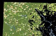
“To define greenness availability exposure, many environmental health studies rely on greenness data derived from satellite image-based indices such as the normalized difference vegetation index (NDVI), which measures the relative abundance and spatial distribution of vegetation…psychologists’ ratings of greenness and NDVI were highly correlated within a buffer distance of 100 m and promoted NDVI as a reasonable measure of neighborhood greenness”(2) “...total greenspace percentages...for three different NDVI value regions (i.e., low 0.2–0.3, mid 0.4–0.5, high 0.6–0.7)” (7)
Martinez, A. de la I., & Labib, S. M. (2023). Demystifying normalized difference vegetation index (NDVI) for greenness exposure assessments and policy interventions in urban greening. Environmental Research, 220, 115155.
“[We] identified that higher NDVI values were significantly associated with better health outcomes...Green space within 500 m of home such as those of 50, 100, 250 and 500 m are often used to represent the immediate neighborhood of residence suitable for physical activity like walking, and in the presence of green space suitable for reducing noise and air pollution” (163)
Su, J. G., Dadvand, P., Nieuwenhuijsen, M. J., Bartoll, X., & Jerrett, M. (2019). Associations of green space metrics with health and behavior outcomes at different buffer sizes and remote sensing sensor resolutions. Environment International, 126, 162–170.
2. Walksheds
“...greenness in immediate proximity (100 m), as well as green space, green corridors reachable within a 10-min walk (up to 800 m distance) and green space uses up to 1000 m are significantly associated with higher physical activity and indirect health effects.”
Cardinali, M., Beenackers, M. A., van Timmeren, A., & Pottgiesser, U. (2024). The relation between proximity to and characteristics of green spaces to physical activity and health: A multi-dimensional sensitivity analysis in four European cities. Environmental Research, 241, 117605. https://doi.org/10.1016/j.envres.2023.117605
“...physical activity behavior undertaken at a destination was consistently associated with the distances respondents were prepared to travel, regardless of the type of facility...travel distances decreased as a function of the number of destinations available within the respondent’s neighborhood, regardless of the type of destination examined. Younger adults, those with a higher income and those from socio-economically disadvantaged areas also tended to travel further to use recreational physical activity destinations.” (7)
McCormack, G. R., Giles-Corti, B., Bulsara, M., & Pikora, T. J. (2006). Correlates of distances traveled to use recreational facilities for physical activity behaviors. International Journal of Behavioral Nutrition and Physical Activity, 3(1), 18.
“We found that travel distance had an exponential limiting effect on park visits. The maximum park visits dropped exponentially as the travel distance to parks increased. No such effect was observed for park size...We identified four cut-off points (1, 2, 5, and 10 km) based on the constraint line functions as the accessible and maximum travel distance regarding different travel modes and visit frequencies of park visits.” (1)
Tu, X., Huang, G., Wu, J., & Guo, X. (2020). How do travel distance and park size influence urban park visits? Urban Forestry & Urban Greening, 52, 126689.
“...routes to the park that cover long distances, potential traffic injury risks, and poor pedestrian environments could be substantial barriers for park visitors. Furthermore, the walkability of streets near parks has been particularly correlated to pedestrian perceptions of safety.” (2)
Zhou, Z., & Xu, Z. (2020). Detecting the Pedestrian Shed and Walking Route Environment of Urban Parks with Open-Source Data: A Case Study in Nanjing, China. International Journal of Environmental Research and Public Health, 17(13), Article 13.
Situating McMinnville...
How does McMinnville relate to the greater Willamette Valley?
Considered a rising leader in Oregon’s wine country, Yamhill county is agriculturally dominated and relatively sparsely populated with 107,000 residents split among 10 cities in the county. Population is expected to rise by 20% by 2050, and wine toursim is expected to expand, resulting in extensions of most town’s urban growth boundaries.

URBAN AREAS
Cities and Highways in the Valley
Transected by Intersate 5 and the Willamette River, the valley serves as the state’s primary population corridor, housing 70% of Oregon’s population. Predicted to double in population by 2050, the region is facing ecological pressures with the expansion of urban and agricultural land conversions.
Oregon’s Willamette Valley is a low-lying, river valley nestled between the Coast Ranges to the west and the Cascades to the east. Characterized by climatic conditions ideal for crop production, the valley is becoming a viticulture hotspot in addition to thriving nursery, produce, and Christmas tree industries.


Developed Land


Agricultural Land


Undeveloped Land

Developed, Open Space
Developed, Low Intensity
... in an Un-Urban County A Rural Context
Developed, Medium Intensity
Developed High Intensity


Cultivated Crops Land Cover
Pasture/Hay Land Cover


Open Water
Deciduous Forest
Evergreen Forest
Mixed Forest

warf Scrub
Shrub/Scrub
assland/Herbaceous
edge/Herbaceous
Lichens
oody Wetlands
Emergent Herbaceous Wetlands


Sparsely Urban and Dominantly Agricultural
At the county scale, land cover reveals that McMinnville is surrounded by a primarily undeveloped context consisting of forest lands and productive agricultural fields. This rural context suggests a pastoral and bucolic character of the region conducive to respite for residents of McMinnville and the greater Portland metropolitan region. The sparse clustering of developed lands demonstrates McMinnville’s relatively isolated positioning in the urban network, reiterating it’s importance as an urban center within the county.

Shelby Stasiowski / REIMAGINING McMINNVILLE’S LIBRARY IN A PARK


URBAN CONTEXT
Connecting City Park to Downtown and Celebrating Winemaking


Connecting City Park to Downtown and Celebrating Winemaking

Section Icon
Research Questions
1. What is the location and relationship of the site to the region’s wine country/winemaking culture?
2. What is the location and relationship of the site to the city’s key cultural and institutional assets?
Geoprocessing
Network Analysis – Service Area
Data Sources
City of McMinnville GIS (Parks, UGB)
Google Earth (Winery Locations)
Oregon Wine Board - American Viticulture Areas (AVA’s)

Literature
American Viticultural Areas. (n.d.). Wine Institute. Retrieved October 27, 2024, from https://wineinstitute.org/our-industry/avas/
Aney, W. (1974). Oregon Climates Exhibiting Adaptation Potential for Vinifera. American Journal of Enology and Viticulture.
Birkin, M., Clarke, G. P., & Clarke, M. (1996). GIS for business and service planning.
Buccola, S., & VanderZanden, L. (1997). Wine Demand, Price Strategy, and Tax Policy. Applied Economic Perspectives and Policy, 19, 428-440.
Slocum, S., & Kline, C. (2017). Linking Urban and Rural Tourism: Strategies in Sustainability. CABI. Retrieved October 26, 2024,
McMinnville Winemaking Culture
The Heart of Oregon’s Wine Country
Nestled in the heart of the Willamette Valley, McMinnville is renowned for its rich winemaking culture, making it a premier destination for wine enthusiasts. This quaint town serves as a hub for some of the finest Pinot Noir production in the United States. The area’s unique ecology, characterized by volcanic and sedimentary soils combined with a cool climate, provides ideal conditions for growing grapes. Winemakers in McMinnville embrace sustainable farming practices, reflecting a commitment to preserving the land’s natural beauty and fertility while producing exceptional wines.
The winemaking community thrives on collaboration and innovation, blending traditional methods with modern techniques. Many of the region’s wineries are family-owned and operated, fostering a close-knit atmosphere that is evident in the warm hospitality extended to visitors. Tasting rooms often feature educational experiences, allowing guests to learn about the meticulous processes behind their favorite vintages.
McMinnville’s wine culture has enriched the town’s overall identity. The cities charming downtown streets are lined with boutique wine shops, farm-totable restaurants, and artisanal food producers, all complementing the region’s winemaking heritage. Local chefs and winemakers collaborate to create exquisite food and wine pairings that highlight the valley’s bounty. This integration of culinary excellence with viticulture has made McMinnville not just a destination for tasting exceptional wine, but a vibrant community that celebrates the art of living well.


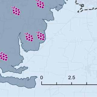


The Wineries
19 Wineries within 20 minutes of Downtown McMinnville
McMinnville is a wine lover’s dream, boasting 19 wineries within just a 20-minute drive of its lively downtown. This density offers unparalleled convenience, allowing visitors to explore multiple vineyards in a single day without extensive travel. Whether perched on scenic hillsides or nestled in serene valleys, each winery provides a unique character and style, offering visitors a rich tapestry of experiences. The ease of access has made McMinnville a standout destination in the Willamette Valley, where the journey to excellent wine is as rewarding as the wine itself.
The diversity of wineries near McMinnville reflects the region’s creative and varied approach to winemaking. Visitors can explore establishments specializing in small-batch productions, experimental blends, or traditional methods passed down through generations. Many wineries feature inviting tasting rooms with stunning views of the surrounding landscape, enhancing the wine-tasting experience. This proximity encourages exploration, allowing visitors to uncover hidden gems that might go unnoticed in a more dispersed wine region. From crisp whites to bold reds, the range of wines available showcases the expertise and passion of local winemakers.
McMinnville’s thriving wine industry has brought substantial economic benefits to the community. The area’s wineries attract tourists from around the world, who contribute to the local economy through wine tastings, vineyard tours, accommodations, dining, and leisure activities. This influx of visitors supports local businesses, from boutique shops to upscale restaurants, creating a vibrant commercial ecosystem centered on wine tourism. Additionally, the industry provides direct economic benefits through job creation, with roles in vineyard operations, wine production, and hospitality. By sourcing goods and services locally, the wineries further strengthen the region’s economy, fostering sustainable growth and innovation in McMinnville.
City Services
How does the city prioritize the site in comparison to downtown?
McMinnville demonstrates a strong focus on developing and enhancing its downtown area, often at the expense of other vital community amenities like the library and city park. Programs such as the McMinnville Downtown Design District and Urban Renewal District show the city’s dedication to revitalizing the downtown core through strict design standards and financial incentives, including grants and low-interest loans. Additionally, the City Center Housing Strategy focuses on creating housing opportunities downtown, particularly for future generations and the aging population. These initiatives collectively highlight the city’s concentrated efforts to make the downtown area a thriving hub of economic and residential activity.
McMinnville City Center Housing Strategy District
Focuses on housing for future generations and the aging population.
McMinnville Urban Renewal District
The city provides grants and low-interest loans for improvements and development.
McMinnville Downtown Design District
Provides standards and guidelines that new development and business must follow.
McMinnville City Services
Location of Library, Fire Department, Police Departments, and City Hall.
The “Dead Zone”
The block between Downtown and the site
The area the Urban Context team has referred to as the “Dead Zone” represents a significant barrier between the City Park and the vibrant downtown core. This block is boxed in by Highway 99W from the east and west. It is host to underutilized urban spaces and poor infrastructure which isolates the park from the surrounding residential neighborhoods and the City Park. As a result, the park feels disconnected, limiting its potential as a hub for recreation, culture, and community engagement. The lack of safe and inviting pathways through this zone discourages pedestrians and cyclists from moving between the park and downtown, creating a physical and psychological divide within the city.
Connecting the City Park to the downtown area through thoughtful urban design could transform this “Dead Zone” into a dynamic corridor that unites residential zones with McMinnville’s core. By investing in infrastructure such as bike lanes, pedestrian-friendly walkways, and green spaces, the area could serve as a seamless gateway that would draw residents and visitors alike. Such a connection would not only enhance accessibility to downtown businesses and cultural attractions but also integrate the park into the daily lives of the community thus strengthening its role as a civic centerpiece. This transformation would help foster a more walkable and cohesive city, bolstering McMinnville’s identity as a welcoming and livable small-town destination.


The Nelson House
History and Culture
The Nelson House in McMinnville stands as a prominent historical landmark within the city’s downtown historic district. This area features a diverse collection of structures from the late 19th and early 20th centuries, showcasing architectural styles that reflect McMinnville’s evolution as a regional hub during that period. Recognized for its historical significance, the district was added to the National Register of Historic Places in 1987, emphasizing its value in preserving the city’s rich architectural and cultural legacy.
The property sits adjacent to key public amenities such as the City Park, Aquatic Center, and Public Library, enhancing its potential as a connector between the residential and downtown areas. Despite its current vacancy, the city aims to preserve its historical value while considering adaptive reuse that aligns with community goals. The house’s future represents an opportunity to honor its past while contributing to McMinnville’s evolving urban landscape
The Urban Context team has identified an opportunity to enhance the Nelson House’s historical relevance by aligning it with McMinnville’s renowned winemaking heritage. The proposal envisions transforming the property into a dynamic hub for the local wine industry. This adaptive reuse could include hosting wine tastings, offering educational programs on viticulture, and establishing a regional grape seed bank to support and celebrate Oregon’s wine culture. Such a project would not only honor the home’s historical significance but also position it as a centerpiece of the city’s vibrant winemaking identity.

Nelson House Opportunities

SEED BANK WINEMAKING CLASSES

Seed banks are vital for preserving genetic diversity and ensuring the sustainability of agriculture, including the cultivation of wine grapes. By storing seeds in controlled environments, seed banks safeguard plant varieties against threats such as climate change, diseases, or natural disasters, offering a vital resource for future replanting and breeding efforts. For wine grapes, seed banks serve a crucial role in maintaining the unique characteristics of grape varieties, supporting innovation in winemaking, and protecting heritage vineyards.
Creating a seed bank for wine grapes involves several steps. Seeds should be collected from healthy, mature grapevines, representing a diverse range of varieties and regions. These seeds must be cleaned, dried, and stored in airtight containers to prevent moisture and contamination. Seed storage requires precise temperature and humidity control, typically in a refrigeration facility, to ensure long-term viability. Comprehensive documentation of each variety, including its genetic makeup and origin, is essential to maximize the seed bank’s utility for research and cultivation. Partnerships with local wineries will be essential for the success of the seed bank.

Winemaking classes provide a unique opportunity for community members to engage with their local wine culture while learning the art and science of winemaking. These classes can cover topics ranging from grape selection and fermentation techniques to bottling and tasting. By fostering hands-on experiences, participants gain a deeper appreciation for the region’s winemaking heritage and its economic and cultural significance. Additionally, these events can strengthen connections between local wineries, residents, and tourists, further promoting the city as a hub for wine education and appreciation.
This begins by collaborating with local wineries and winemakers to create an engaging curriculum that covers topics like grape growing, fermentation, blending, and tasting. Leveraging the house’s proximity to McMinnville’s downtown, the classes can be designed to provide handson experiences and foster deeper connections to the region’s winemaking heritage. Partnerships with the local tourism board and wine associations can help promote the program, while themed workshops and seasonal events can attract both residents and visitors. .
Connecting City Park to Downtown and Celebrating Winemaking
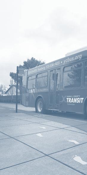
Wine Tour Bus Routes
An innovative new way to promote public transportation into peoples lives.
A more ambitious goal for connecting the City Park and Library to the wine regions would be through a partnership with the Yamhill County Transit system to provide safe travel to wineries departing from the Nelson House. Currently the YCT does not operate in McMinnville on the weekends. Public transportation ridership is low in McMinnville. Giving residence and tourists an opportunity to ride these buses in a fun and safe way would not only be a great weekend activity, but also show these riders that public transportation is a safe and sustainable way to get around their city.
Connecting public transportation to the wineries in the McMinnville area, departing from the historic Nelson House, presents an exciting opportunity to enhance accessibility and promote sustainable tourism. By establishing the Nelson House as a transportation hub, the city can link local and regional transit services to popular winery destinations. This initiative would not only support residents seeking eco-friendly travel options but also attract tourists eager to explore Oregon’s celebrated wine country without the need for personal vehicles. Additionally, bike-friendly buses departing from the Nelson House could expand upon McMinnvilles already robust bicycling trail system and give the cyclists a place to safely park their cars.
Such a network could also incorporate partnerships with local wineries to offer curated wine trails, seasonal events, and collaborative promotion. Thus, making public transportation an integral part of the winery experience. By reducing reliance on car travel, the initiative would contribute to lowering traffic congestion and environmental impact while supporting the local economy. The Nelson House’s proximity to the City Park, Library, Residential Zones, and Downtown further enhances its potential as a central hub, connecting residents and visitors to multiple cultural and recreational activities, enriching their experience of McMinnville as both a historic and progressive community.
Possible Wine Bus Routes
URBAN CONTEXT
Connecting City Park to Downtown and Celebrating Winemaking


Connecting City Park to Downtown and Celebrating Winemaking
The Conclusion
Connecting City Park to Downtown and Celebrating Winemaking
To conclude, McMinnville has an incredible opportunity to build upon its rich heritage and thriving wine culture by embracing new ideas that enhance connectivity, sustainability, and community engagement. By reimagining the “Dead Zone” as a vibrant corridor connecting City Park to downtown, the city could transform an underutilized area into a dynamic space for pedestrians and cyclists. Creating safe, inviting pathways and green spaces would not only improve accessibility but also encourage residents and visitors to explore all that McMinnville has to offer. This initiative would strengthen the city’s identity as a walkable, cohesive destination while promoting recreation and cultural integration.
Additionally, the historic Nelson House presents an ideal opportunity to honor McMinnville’s past while supporting its future. Transforming this landmark into a hub for the wine industry could include hosting wine tastings, educational programs on viticulture, and even a regional grape seed bank. Such an adaptive reuse would celebrate McMinnville’s winemaking heritage while fostering innovation and sustainability. Leveraging the house’s central location, the city could also establish it as a transportation hub, linking downtown to nearby wineries through eco-friendly public transit options, such as bike-friendly buses and curated wine trails. This approach would reduce traffic congestion and environmental impact while enhancing the experience for both residents and tourists.
To further integrate the community with its winemaking identity, McMinnville could offer hands-on winemaking classes and other educational opportunities that allow people to connect with the art and science of viticulture. These programs could bring residents and visitors closer to the region’s winemaking roots while strengthening relationships between local wineries and the community. Coupled with partnerships between chefs and vintners to showcase food and wine pairings, these initiatives would solidify McMinnville as a destination for culinary and cultural excellence.
By embracing these ideas, McMinnville can create a more connected, sustainable, and vibrant community. Revitalizing key areas and leveraging its historical and cultural assets will not only preserve the city’s charm but also propel it toward a future that balances growth with livability. With thoughtful planning and innovative solutions, McMinnville can continue to shine as a premier destination for wine, culture, and quality of life.


Research Question
1. What is the site’s relationship to public transit lines and bike paths?
2. How does the state highway influence the soundscape for park and library visitors?
Geoprocessing
Network Analyst:
1. Bike Sheds
2. Closest Facilities
Data Sources
City of McMinnville GIS (Roads, city limits)
TomTom (Traffic density)
Oregon Department of Transportation (Roads, bike paths, transit)
ESRI Database & Google Earth (Asset Mapping)


Literature
Clark, C., Crumpler, C., & Notley, H. (2020). Evidence for Environmental Noise Effects on Health for the United Kingdom Policy Context: A Systematic Review of the Effects of Environmental Noise on Mental Health, Wellbeing, Quality of Life, Cancer, Dementia, Birth, Reproductive Outcomes, and Cognition. International Journal of Environmental Research and Public Health, 17(2), 393. https://doi. org/10.3390/ijerph17020393
Domeneghini, J., Borges Yonegura, V., & Silveira, A. L. L. D. (2023). URBAN PARKS WITH ADJACENT BIKE LANES: A FACTOR IN ATTRACTING CYCLIST USERS? In Revista Percurso - NEMO Maringá, Revista Percurso - NEMO Maringá (Vol. 15, Issue 1, pp. 53–81) [Journal-article].
Lan, Y., Roberts, H., Kwan, M., & Helbich, M. (2020). Transportation noise exposure and anxiety: A systematic review and meta-analysis. Environmental Research, 191, 110118. https://doi.org/10.1016/j. envres.2020.110118
Salon, D., Wang, K., Conway, M. W., & Roth, N. (2019). Heterogeneity in the relationship between biking and the built environment. Journal of Transport and Land Use, 12(1), 99–126. https://www. jstor.org/stable/26911260
Will Hackney, Esri’s StoryMaps team, with Craig McCabe, Esri’s Living Atlas of the World team. (2023, March 22). Creating a model to analyze bike accessibility. ArcGIS StoryMaps. https://storymaps.arcgis.com/stories/1b4ad355268c456a956f0c2bcb1874e4


The bike paths in Mcminnville are limited and converge into shoulder paths around the city and more specifically on the state highway when approaching the library. Biking through Mcminnville is much like any other small city, but to increase biking in and around the park would require new bike paths as well as protected ones along the state highway and other high traffic roads. Increasing bicycle infrastructure is positively correlated with biking activity so it must be encouraged in the redesign of this area. Having an unprotected bike path on the side of the highway is unsafe and unfavorable by cyclists which can limit bike transportation.
Utilizing the Park
Safer routes within the site
Existing routes
Proposed routes


this when pedestrians are traveling east to west or vice

Piombo


Noise Disturbance
1”=100’
1”=25’
Cristian Piombo / REIMAGINING McMINNVILLE’S


In Soundscape Quality in Suburban Green Areas and City Parks, research found that good soundscape quality can only be achieved if the traffic noise exposure in city parks during day time is below 50 decibels. A study done at Utrecht University in the Netherlands found higher odds of anxiety associated with a 10 decibel increase in daily noise level (cite). We took decibel readings at each major intersection surrounding the park and all results exceeded that 50 db. This is an opportunity to explore design possibilities for minimizing or buffering these sounds and increasing natural sounds within the park.
Top Floor


Research Questions
Section Icon
Section Icon


Research
Research Question
Question
SF1a-1c: “What is the role public parks play in a city? How do the people of McMinnville feel about their parks? Which key demographics will affect our design?”
• What is the roll public parks play in a city?
• What is the roll public parks play in a city?
-Jennifer Gingrich
• How do the people of McMinnville feel about their parks?
• How do the people of McMinnville feel about their parks?
• Which key demographics will affect our design?
• Which key demographics will affect our design?
Research Question
Research Question
SF2a-2b:”To what extent do parks and greenspaces impact a community’s overall health?
How might we expand the park’s programming throughout the year to increase park usage among new demographics?”
• To what extent do parks and greenspaces impact a community’s overall health?
-Darren Chan
• To what extent do parks and greenspaces impact a community’s overall health?
• How might we expand the park’s programming throughout the year to increase park usage among new demographics?
• How might we expand the park’s programming throughout the year to increase park usage among new demographics?
Research
Research Question
Question
SF3: “What inequities impact McMinnville City Park and how could it be improved to better serve disenfranchised groups?”
-Alejandro Bechtel
• What inequities impact McMinnville City Park and how could it be improved to better serve disenfranchised groups?
• What inequities impact McMinnville City Park and how could it be improved to better serve disenfranchised groups?
Research Question
Research Question
SF4a-4c: “How safe do people feel in the park? What makes a park feel safe? Where are the blind spots on the site from a public safety perspective?”
• How safe do people feel in the park?
• How safe do people feel in the park?
-Cosette McCave
• What makes a park feel safe?
• What makes a park feel safe?
• Where are the blind spots on the site from a public safety perspective?
• Where are the blind spots on the site from a public safety perspective?
Research Question
1. What is the roll public parks play in a city?
2. How do the people of McMinnville feel about their parks?
3. Which key demographics will affect our design?
Geoprocessing
Geoenrichment from the 2020 Census Data
Data Sources
2022-2023 McMinnville Online Questionnaire
City of McMinnville Website McMinnville 2020 Census Data


Literature
Bureau, U. C. (2024, November 18). U.S. Census Bureau homepage. Census.gov. https://www. census.gov/
Home Page. Home Page | McMinnville Oregon. (1970, January 1). https://www.mcminnvilleoregon. gov/
Needs assessment. McMinnville PROS Update. (n.d.). https://mcminnville-parks-plan-migcom.hub. arcgis.com/pages/needs-assessment
Shepley, M., Sachs , N., Sadatsafavi, H., Fournier, C., & Peditto , K. (n.d.). The impact of green space on violent crime in Urban Environments: An evidence synthesis. International journal of environmental research and public health. https://pubmed.ncbi.nlm.nih.gov/31847399/
Speer, J. (n.d.). The politics of park design a history of urban parks in America | books gateway | MIT press. Taylor & Francis Online. https://direct.mit.edu/books/oa-monograph/5052/The-Politics-of-ParkDesignA-History-of-Urban
Tefera, Y., Soebarto, V., Bishop , C., & Kandulu, J. (n.d.). A scoping review of urban planning decision support tools and processes that account for the health, environment, and economic benefits of trees and greenspace. International journal of environmental research and public health. https:// pubmed.ncbi.nlm.nih.gov/38248513/
U.S. Census Bureau quickfacts: Oregon. (n.d.). https://www.census.gov/quickfacts/fact/table/OR/ INC110222
The official tourism website of Mcminnville, Oregon. Visit McMinnville. (2024, November 22). https:// visitmcminnville.com/?fbclid=IwY2xjawG8dItleHRuA2FlbQIxMAABHczZHs-aKzr75Hzw3l3tCtksdgN K24z9WfqBkUGSmEijU0AQaQMau4CzTg_aem_-8WDrq6lOMSfEC7JyY1lWw
The Residents of McMinnville
Public Parks are the Lifeblood of Thriving, United Cities
Public parks directly reflect a city’s health by showcasing the values and priorities of its community. Parks are essential urban green spaces that serve as cultural hubs and drive economic investment.
They provide safe places for people to connect through diverse expressions of art, music, and community events. Parks are among the few large, flexible public spaces in cities, capable of hosting activities such as art installations, farmers’ markets, and festivals.
Parks also boost a city’s economy. In Oregon, local park and recreation agencies generate $2 billion annually. They attract tourism, enhance property values, and support local businesses. Many people also consider parks when deciding where to live or vacation.
As vibrant green spaces, parks support urban ecosystems by reducing air, water, and noise pollution, regulating temperature, and recycling water. They act as barriers to surface runoff, prevent soil erosion, and support biodiversity by providing crucial habitats for wildlife.
Moreover, people benefit from increased exposure to green spaces. Those who experience more green space in their daily lives enjoy better mental and physical health, improved mood, enhanced focus, and stronger cognitive function, all of which translate into higher workplace efficiency.
Finally, parks help reduce urban crime through passive surveillance and by fostering stronger, more connected communities.

The Residents of McMinnville
Community Outreach

In Summer 2022, the City of McMinnville began updating its Parks, Recreation, and Open Space Master Plan to assess community priorities and identify recommendations for enhancing parks, recreation facilities, trails, programs, events, and related services. As part of this process, the city launched an online questionnaire, inviting residents to share their values, visitation needs, desired improvements, potential new park locations, and preferences for recreation programs.
The Questionnaire Results
The McMinnville Word Cloud
This word map highlights the most common words used in the survey responses in the public survey.
Above all, residents love their parks! The survey revealed that 95% of respondents rated parks as one of the most important spaces in town, and 70% reported visiting parks at least once a week.
Additionally, McMinnville residents expressed a strong interest in co-ownership of their parks, desiring greater involvement by utilizing these open spaces for personal or community projects, both planned and spontaneous.
The survey also emphasized a clear interest in fostering collaboration between schools and parks. Suggestions included sharing facilities, creating joint programs, and integrating parks into everyday education. These initiatives would benefit everyone by expanding students’ learning environments and fostering responsibility through participation in the upkeep of public spaces.

The Questionnaire Results
The Big Eight

Needs assessment. McMinnville PROS Update. (n.d.). https://mcminnville-parks-plan-migcom.hub.arcgis.com/pages/needs-assessment
The city reviewed all the survey comments and identified eight key areas for improvement. From enhancing safety to increasing equity opportunities and prioritizing the enhancement of existing parks over building new ones, the people of McMinnville have shown a deep commitment to their public spaces and a desire for comprehensive improvements.
During our site visit, we spoke directly with McMinnville residents and found a strong desire for The City Park to be cleaner, safer, and more accessible.
Residents also expressed pride in their town’s rich history and a strong interest in preserving the historical significance of the parks. They emphasized the importance of maintaining and expanding existing historical installations to provide more educational opportunities for visitors to learn about and appreciate the parks’ historical value.
The Residents of McMinnville
The Winners
The City of McMinnville also asked residents to identify their favorite parks. The City Park was consistently rated as either the most popular or the second most popular across all four categories: Fun and Play, Relaxation, Sports and Fitness, and Events.
This highlights the City Park’s significant potential to become a true community anchor, as it is centrally located where all three wards of the city meet.
Moreover, with its existing reputation as the most popular park for events, we, as designers, have a strong foundation to develop the park into a central hub for the community.


Demographics
Neighbourhoods and Wards

Breaking down crime by category reveals some differences among the three wards. Surprisingly, while Wards 1 and 2 are generally safer, they have higher rates of personal crimes, particularly assault. In contrast, Ward 3 has a more balanced distribution of crime types, despite its higher overall crime rating.
City Park, located near Downtown and McMinnville’s eastern neighborhoods, offers an excellent opportunity to improve safety.
By enhancing this central space, the park can help address safety concerns and foster stronger community connections, resulting in helping the reduction of urban crime.
Demographics

Crime Breakdown by Ward
Demographics

The average household income across the three wards ranges from $60,000 to $70,000. This is below Oregon’s average of $75,000 but well above the federal poverty level of $20,000 for a twoperson household, which represents the majority of household types in McMinnville.
This indicates that McMinnville’s average household income is slightly below the state average but far above the federal poverty level.
Crime Breakdown
When we put the crime and average household income maps side by side, we can deduce that living in wealthier neighborhoods correlates with safer conditions. The maps show that the two highest-income blocks have the lowest crime rates. Additionally, as we move from the wealthier outer suburbs toward the center of the city, we see crime rates rise as income levels decrease.
Creating a city anchor with City Park can provide significant benefits in addressing these disparities. By enhancing this central public space, the park can foster community engagement, promote safety, and help bridge the gap between higherand lower-income neighborhoods. As a well-designed, vibrant hub, the park can attract positive activity, improve surrounding areas, and contribute to a more connected and safer community citywide.
Demographics Comparing Crime and Income


User Profiles
Raw data is excellent for making educated guesses and gaining overall perspectives, but at the end of the day, data is just a tool. Like any other tool, it lacks real impact without empathy, conviction, and imagination to support it. That’s where our user profiles come in.
As a group, we have identified key user profiles that represent both the current and potential users of our site.
My teammates will incorporate these profiles throughout their presentations. While not all of them will be directly referenced, we strongly believe each one plays an essential role in weaving together the social fabric of The City Park.
Friend Groups Teenagers

Dog Owners Tourists

To what extent do parks and greenspaces impact a community’s overall health?
How might we expand the park’s programming throughout the year to increase park usage among new demographics?
Geoprocessing
Clima Tool: UTCI Heatmap Chart 3D Path Analysis
Data Sources Research Question
• Evenson, K. R., Shay, E., Williamson, S., & Cohen, D. A. (2016). Use of Dog Parks and the Contribution to Physical Activity for Their Owners. Research Quarterly for Exercise and Sport, 87(2), 165–173. https://doi.org/10.1080/02701367.2016.1143909
• Grilli, G., Mohan, G., & Curtis, J. (2020). Public park attributes, park visits, and associated health status. Landscape and Urban Planning, 199, 103814. https://doi.org/10.1016/j.landurbplan.2020.103814
• Hobbs, M., Green, M. A., Griffiths, C., Jordan, H., Saunders, J., Grimmer, H., & McKenna, J. (2017). Access and quality of parks and associations with obesity: A cross-sectional study. SSM - Population Health, 3, 722–729. https://doi.org/10.1016/j. ssmph.2017.07.007


Literature
Lack of access to parks can lead to Negative Health Impacts: Physical, Social
Study 1: United Kingdom (2017)
• “Those who lived in moderately, or highly deprived areas [from parks] were more likely to be obese” (Hobbs, et. Al, 2016)
• “Parks located in areas with already fewer green spaces tend to experience higher incivilities [e.g. crime, vandalism, etc.]” (Hobbs, et. Al, 2016)
Higher number of park visits can lead to Positive Health Impacts: Physical, Mental , Social
Study 2: Rio de Janeiro - 2018
• “Mortality rates for ischemic heart and cerebrovascular diseases were inversely associated with [greenspace] exposure” (Grilli, et. Al, 2018)
• Higher frequency of park visits = lower mortality heart rates and brain disease
Study 3: Ireland - 2016
• Study of 1,050 Irish adults living in urban areas
• “At 1 visit to [greenspaces] per month, the associated probability that an adult has good mental well-being is 69%, rising to 76% with 8 [greenspace] visits per month (i.e. twice per week)” (Evenson et.al, 2016).
• Mental health benefits of parks = higher frequency of visits
Study 4: United States - 2016
• Collection sites included dog parks in Chapel Hill, NC, Los Angeles, CA; and Philadelphia, PA.
• “Dog or pet owners report significantly more physical activity, walking, or exercise than non-dog owners” (Evenson et.al, 2016).
• Pet owners “routinely talked with other regulars who were visiting the dog area... opportunities to meet neighbors and build a sense of community” compared to regular parks that encourage less social contact
McMinnville Site Visit
Semi-structured Interviews with Locals


Based on academic studies’ findings and City Park user profiles, we analyzed park activities to explore ways that it currently promotes physical, mental, and social health benefits. Among the people our group engaged with, here were the most common user demographics of City Park:
1. Dog walkers (despite, No Dogs Allowed park)
2. Families with children
3. Students/Library goers

Activities at McMinnville City Park which can offer which provide physical, mental, and social health benefits with their locations mapped.
Activity Frequency Analysis
A speculative year-round analysis of park usage based on climate and precipitation patterns

Year-Round McMinnville Climate Graph

Year-Round McMinnville Precipitation Graph

Example of Activity Frequency Analysis Graph
The activity is primarily extracted from events that currently take place/programmed at the park or the library. Some of the listed activities are unsanctioned activities such as dog-walking and canoing. Morning and evening visitors doing the same activity are discerned by the sun or moon icon.
Physical Activity Frequency Analysis
A speculative year-round analysis of park usage for Physical Activity


Physical activity is most prevalent in the early mornings and evenings through dog walking* and running. We speculate that since the summer months can get up to 100 degrees Fahrenheit, these activities may be present but less frequent than in the late spring and early fall. In rainy months, Lower Park can get so flooded to the point where visitors can canoe*.
*Dog walking and canoeing are currently unsanctioned activities at City Park
Mental Activity Frequency Analysis
A speculative year-round analysis of park usage for Mental Activity


Mental activities can be present throughout the entire day at City Park. From exercising to relaxing, to reading at the park, relaxing, these activities also depend on what the weather permits.
While not shown on this graph because we did not physically observe this, we recognize that homeless communities might use the park at any hours of the day/night so that is important to consider as we plan and design for this projectto not only increase the feeling of safety for park users, but doing so while not implementing any hostile architecture to exclude any members of the community.
Social Activity Frequency Analysis
A speculative year-round analysis of park usage for Social Activity


These social activities consist of community events taking place in McMinnville. These include but are not limited to children’s storytime and writers workshops in collaboration with the library, civic meetings, interest groups, and festivals (currently, the Walnut Music Festival takes place at City Park every August).
Activity Frequency Analysis Comparison
This chart depicts the activity frequency graphs in their discrete rows and their respective health benefit categories.

Activity Frequency Analysis Synthesized

Each of the three health benefits overlayed on top of each other onto the calendar graph. The most active times for park usage is during:
• Mornings (8-11AM) and afternoons (2 - 7PM) during the warmer months (April through September) of the year.
Programming Opportunities

This overlay more importantly shows the gaps in park usage to analyze the times where there is potential for formalized park programming:
• 10AM – 6PM during the late fall through early spring (October through April)
• 9PM-6AM during ALL months
Programming Opportunities
Examples of Activities Day to Night
Day time Park Programming:


Night time Park Programming:


Flea Markets
Glow in the dark Activities
Night time Disc Golf
Stargazing
Live Performances
Night Markets
Community Dog Playtime
Pop-up Shop(s)
Canoeing
Outdoor Storytime
Physical Health Programming Programming Recommendations
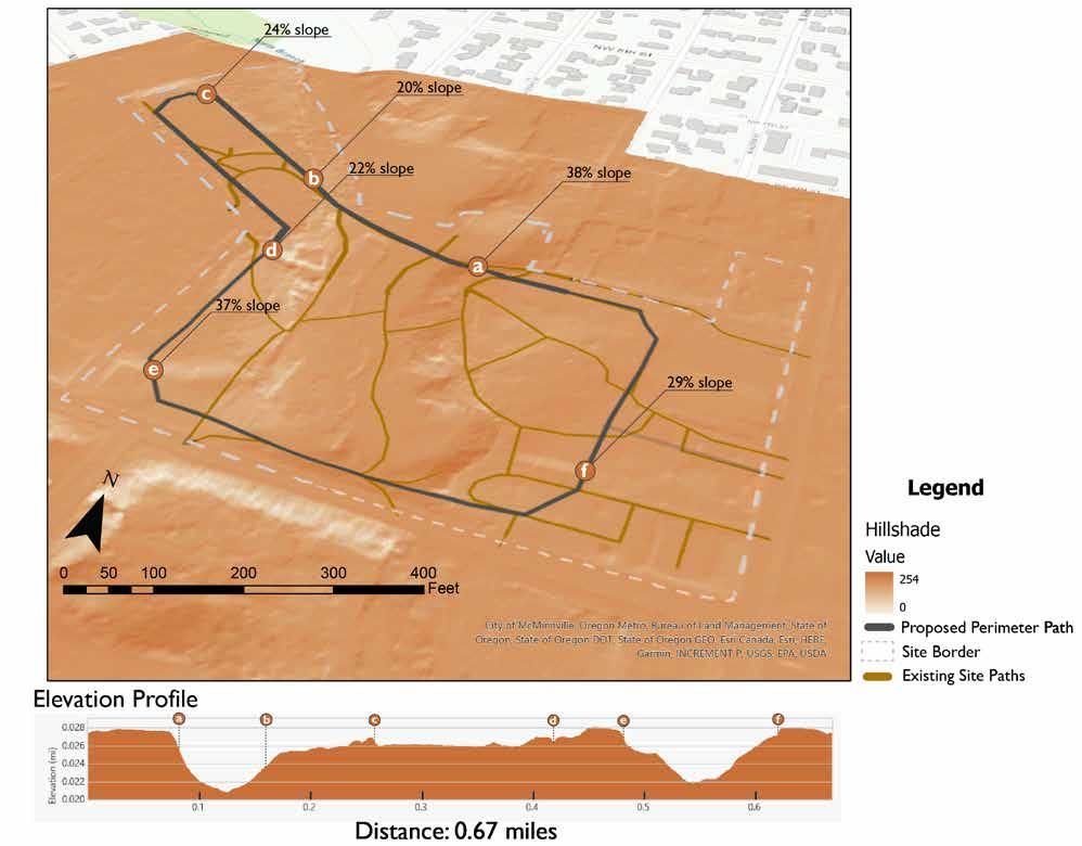
There is currently no accessible circulatory path at the City Park. This is a speculative path that walks the perimeter of the park. This graphic shows a 3D Path Analysis done through ArcGIS with the site’s topography data with the highly steep and inaccessible points called out.
Programming Recommendations
Social Health Programming


These events currently do not take place at City Park, with the exception of Walnut Music Festival. They all have the potential to be programmed to be located in the park. This will allows the park to engage with a range of new users along with more seasonal opportunities, especially during our targeted, more vacant months of October through April
These events may benefit from implementing a main social gathering space, such as an amphitheater, for large-scale city-wide events.
Conclusions
Health of the McMinnville Community
To what extent do parks and greenspaces impact a community’s overall health?
• Physical, mental, and social health benefits within a community
• Many park activities are not mutually exclusive – can apply to several categories
How might we expand the park’s programming throughout the year to increase park usage among new demographics?
• Accessible circulatory path
• Central social gathering hub
We believe that formalized and accessible programming of popular social events, sports, and activities will not only welcome a wider audience to City Park, but also to maintain continuous park usage throughout the entire year.


Research Question
How safe do people feel in the park? What makes a park feel safe? Where are the blind spots on the site from a public safety perspective?
Geoprocessing
Viewsheds
Data Sources
Map data: OpenStreetMap contributors Microsoft Building Footprints. Scene layer: ESRI
Source: Airbus, USGS, NGA, NASA, CGIAR, NLS, OS, NMA, Geodatastyrelsen, GSA, GSI and the GIS User Community, City of McMinnville, Oregon Metro, Bureau of Land Management, State of Oregon, State of Oregon DOT, State of Oregon GEO, Esri Canada, Esri, HERE, Garmin, INCREMENT P, USGS, EPA, USDA

Literature
RASC Dark-Sky Protection Programs (March 2008). Guidelines for Outdoor Lighting (Low-Impact Lighting).
Ross, P. R. & Rutten, N. (2022). Light Sketching for Ecology: A cooperative design tool for balancing human experience and ecological impact.
Wahl, S., Enge (lhardt, M., Schaupp, P., Lappe, C., & Ivanov, I. V. (02 September 2019). The inner clock - Blue light sets the human rhythm
Wekerle, G. (01 July 2000). From Eyes on the Street to Safe Cities.
Wortley, R. & Mazerolle, L. (n.d.). Criminology and Crime Analysis: Chapter 9 – Crime Prevention Through Environmental Design
Current Conditions
McMinnville City Park
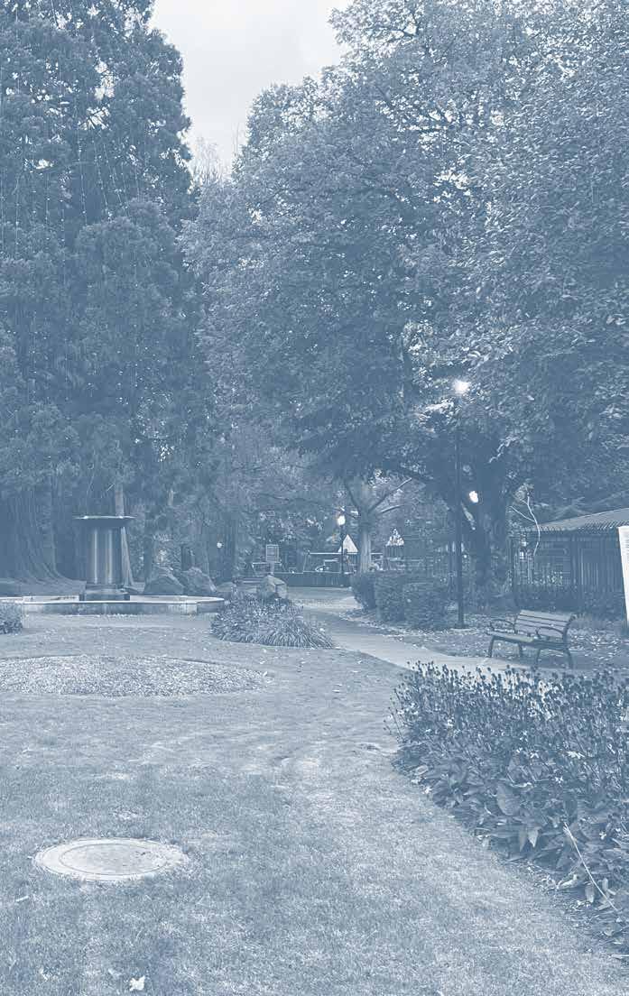
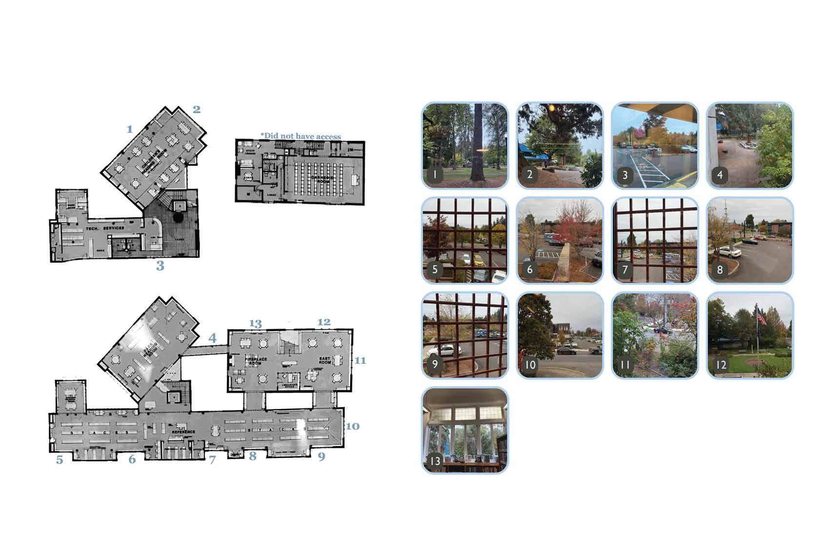
The park is broken up into three sections: the upper terrace, lower terrace, and pickle ball courts. Out of each section, the lower terrace is perceived as the most unsafe area. There are two shelters within the lower terrace. Each have a large amount of graffitti and trash. The lighting throughout the park is insufficient for feeling safe within the park. The paths have low visibilty due to the terrain and heavy tree cover.
Image 1 shows a shelter in the lower terrace that is currently being used for unwanted behavior. The line of site in and outside of the shelter is very limited.
Image 2 displays some of the unwanted behavior occurring there. We found drug paraphernalia on the picnic table. While looking around the shelter, there was a large amount of trash and graffiti. Image 3 is an example of the low lighting that can make the area feel unsafe at night and keep offenders unseen under the cover of darkness and limited sight lines.
Image 4 one of many paths throughout the site. Some are paved, and some are dirt, but none of them feel accessible to everyone or very safe. Most paths weave through heavily forested parts of the park where visibility is the worst.


1 2 3 4


An Overview CPTED Principles
According to Chapter 9 of Criminology and Crime Analysis, Crime Prevention Through Environmental Design, or CPTED, “…can be used to design or modify environments to reduce opportunities for crime and the fear of crime.” There are 6 principles within CPTED.
The first principle is territorial reinforcement. This tactic promotes a sense of ownership for people using the space how it was intended. Therefore, discouraging unwanted behavior. Examples of this include symbolic barriers, such as signs or pavement designs, and real barriers, like fences or designs that clearly define and delineates between private, semi-private, and public spaces.
The next principle is natural surveillance. Surveillance produces a feeling of guardship. If potential offenders feel they are being observed, even if they’re not, they are less likely to offend. There are also more formal or organized types of surveillance, such as police and security patrols, or mechanical surveillance strategies, such as street lighting and CCTV.
Natural access control is the third principle. It focuses on reducing crime opportunities through spatial definition to deny access to and create a feeling of heightened risk for possible offenders. Examples include formal or organized access control, such as security personnel, and mechanical access control, such as locks and bolts.
The fourth principle is activity support. This strategy uses design and signage to encourage the intended use of the space. The increased use of a space makes it feel safer and can draw people to the location. Putting “more eyes on the street” helps to discourage unwanted behavior.
The next principle is space management. This is when a place is adequately maintained and promotes a positive image allowing effective use of the space.
The final principle is target hardening. It involves limiting access to possible unwanted behavior through fences, gates, locks, alarms, and security patrol. There are many times the principles cross over and promote each other.
After our site visit and discussion with stakeholders, natural surveillance, territorial reinforcement, and activity support seem to be the most relevant principles for the needs of the site.
Specific
Site Specific
Principles
site visit and discussion with stakeholders, natural surveillance, territorial reinforcement, and activity support seem to most relevant principles for the needs of the site.
After our site visit and discussion with stakeholders, natural surveillance, territorial reinforcement, and activity support seem to be the most relevant principles for the needs of the site.

Territorial Reinforcement

Natural Surveillance
Natural Surveillance

Activity Support
Territorial Reinforcement
Activity Support
R. & Mazerolle, L. (n.d.). Criminology and Crime Analysis: Chapter 9 –Crime Prevention Through Environmental Design.
R. & Mazerolle, L. (n.d.). Criminology and Crime Analysis: Chapter
Crime Prevention Through Environmental Design.
Wortley,
Wortley,

Everyone is Welcome Inclusion
A critical goal of our work is to welcome everyone to the park regardless of their status. Solving the complex challenge of people experiencing homelessness is above outside our scope as designers, but we can add resources within our designs to help those communities in need. Our work on this project is meant to increase the feeling of safety within the park for all and not exclude anyone. CPTED principles will help us accomplish this goal without implementing any hostile architecture.
2 SOCIAL FABRIC -
Titles Subtitle
Ulluptatur? Ibeatin nonsend itioris audandio dit ium ut esecus, si odit, offic to blatet rerferovit resequunto te vendame voluptas delecabo. As conest elestis rem quiaspe rspellibus doloreptat quat volorror molorem velignim quidenitasi offictis et aut et facit que endi cus. Nam que endicius. Obit ipsamet laut et late nulpari bearum as con none cus.
Ovid magnatem et reptati beaquam et alite videriorum et esti volesed ut aut re, quae ipient pa si culpa nihitatem voles debis accusandem exceperum illabor erruptature dignis pernatiant et es sita quasped maximusam volore vollabo. Ut voluptatior sam, sum quatqui totasperis earchic iatiant iatiore poribus aut quatest, quiame adipsam es aciduci berchil ipsant am la cum quae volut pta epeles ipsum rest aut ut aut de volor re evellique il iuntorumquam fugitae runtiur sinciist volupid quidi omnieni sitibus, sim adi nonesecum quis quas rehendestrum quis volupta quidest, omnihic totaten imaiore natem sin nonsedit aut volupta saerum, nihillu ptationet quae cusdand aectaep erovid earci doloriatem volorem oluptia venimus tiuntioritem que iunt eostorr ovidus et id quiamus am, nis dolluptam, sunt voluptatem fuga. Et odis ressitiust aut quo con comnis eos adio to ilibusa perum, cus ullupta illupta tatiorrovit offic tem ilitatest, in rerro blamus eiunt recabores et que voloria sitae de corehenis dollit et magnist hic te nimus. Itati nonsequam volore pratium exero ea poreperum aut eium
Brightness Lighting
Brightness Lighting
People prefer lower level lighting along paths. One option is lights that can adjust as the moon phases change. This keeps the lighting at the preferred brightness. In regard to safety, having too much glare makes it hard to navigate the park paths or see who or what is around the corner. Having adjustable, dim lighting can make it easier to travel through the park and increase the feeling of safety.
Height Lighting Height Lighting
Titles Subtitle
Ulluptatur? Ibeatin nonsend itioris audandio dit ium ut esecus, si odit, offic to blatet rerferovit resequunto te vendame voluptas delecabo. As conest elestis rem quiaspe rspellibus doloreptat quat volorror molorem velignim quidenitasi offictis et aut et facit que endi cus.
Nam que endicius. Obit ipsamet laut et late nulpari bearum as con none cus. Ovid magnatem et reptati beaquam et alite videriorum et esti volesed ut aut re, quae ipient pa si culpa nihitatem voles debis accusandem exceperum illabor erruptature dignis pernatiant et es sita quasped maximusam volore vollabo. Ut voluptatior sam, sum quatqui totasperis earchic iatiant iatiore poribus aut quatest, quiame adipsam es aciduci berchil ipsant am la cum quae volupta epeles ipsum rest aut ut aut de volor re evellique il iuntorumquam fugitae runtiur sinciist volupid quidi omnieni sitibus, sim adi nonesecum quis quas rehendestrum quis volupta quidest, omnihic totaten imaiore natem sin nonsedit aut volupta saerum, nihillu ptationet quae cusdand aectaep erovid earci doloriatem volorem oluptia venimus tiuntioritem que iunt eostorr ovidus et id quiamus am, nis dolluptam, sunt voluptatem fuga. Et odis ressitiust aut quo con comnis eos adio to ilibusa perum, cus ullupta illupta tatiorrovit offic tem ilitatest, in rerro blamus eiunt recabores et que voloria sitae de corehenis dollit et magnist hic te nimus. Itati nonsequam volore pratium exero ea poreperum aut eium quibea dionsequi dis es archit rem eatur abo. Dicit, con nos doluptatus eatione endus derovit atinus sintiore omnihil libusap iendisc illitam alis quatibus, soles es corem est, aritatet faccatiis molecta tatecab orepedi sequiscipiet abo. Nem quiasperum voloribus as qui toribus, ulpa nis nis estrum aute rae. Et qui dolorum quae ommolo con comnis molo to idunt omnimpos est, quam aut aliquid mi, ium
Height of lighting can affect people’s experience of the park. The higher the lighting, the more glare can occur, especially for people with visual impairments. It can also be effective to aim lights away from the path to help prevent glare. Plus it can showcase the vegetation along the paths. Birds use the stars to navigate, so when light pollution reduces star visibility it also disrupts their navigation. Ross, P. R. & Rutten, N. (2022).
Titles Subtitle
Ulluptatur? Ibeatin nonsend itioris audandio dit ium ut esecus, si odit, offic to blatet rerferovit resequunto te vendame voluptas delecabo. As conest elestis rem quiaspe rspellibus doloreptat quat volorror molorem velignim quidenitasi offictis et aut et facit que endi cus. Nam que endicius. Obit ipsamet laut et late nulpari bearum as con none cus.
Ovid magnatem et reptati beaquam et alite videriorum et esti volesed ut aut re, quae ipient pa si culpa nihitatem voles debis accusandem exceperum illabor erruptature dignis pernatiant et es sita quasped maximusam volore vollabo. Ut voluptatior sam, sum quatqui totasperis earchic iatiant iatiore poribus aut quatest, quiame adipsam es aciduci berchil ipsant am la cum quae volut pta epeles ipsum rest aut ut aut de volor re evellique il iuntorumquam fugitae runtiur sinciist volupid quidi omnieni sitibus, sim adi nonesecum quis quas rehendestrum quis volupta quidest, omnihic totaten imaiore natem sin nonsedit aut volupta saerum, nihillu ptationet quae cusdand aectaep erovid earci doloriatem volorem oluptia venimus tiuntioritem que iunt eostorr ovidus et id quiamus am, nis dolluptam, sunt voluptatem fuga. Et odis ressitiust aut quo con comnis eos adio to ilibusa perum, cus ullupta illupta tatiorrovit offic tem ilitatest, in rerro blamus eiunt recabores et que voloria sitae de corehenis dollit et magnist hic te nimus. Itati nonsequam volore pratium exero ea poreperum aut eium
Blue light suppresses melatonin secretion, so at night it can disrupt our circadian rhythm which reduces sleep, lowers cognitive function, and increases risk of depression and anxiety. Insects are attracted to blue light, which can kill them. They also need darkness to reproduce, so light can interrupt that process. The goal is to stay within a wavelength of approximately 600 to 700 nanometers.
Macula cornea Lens
Wahl, S., Enge (lhardt, M., Schaupp, P., Lappe, C., & Ivanov, I. V. (02
Viewsheds
Library and Police Station

When analyzing for visibility from the police station and library, you can see that almost all of the lower terrace is not visible. The lower terrace is where much of the unwanted behaviors occur; such as the grafitti, littering, and drug use discussed above. The lack of visibility means less surveillance, allowing people to feel more comfortable to offend. It is also important to consider how the trees would help to create even more of a barrier for visibility.
Viewsheds
Northwest Path
Another concern for safety is the visibility along paths. From the northwest corner of the park, there is limited visibility towards the lower terrace and to some parts along the path. There is a large amount of trees throughout this area that block off visibility to the surrounding buildings and other parts of the park.

The viewshed from the southern edge has more visibility than the other locations I chose. When we were walking around the site, the southern edge paths had an open view looking down to the lower terrace, but the paths seemed inaccessible
Viewsheds
Central Path
The viewshed placed on the central path appears to have a medium amount of visibility with a majority being obstructed by buildings. Although, when you take into account how heavily forested this path is, there would be little to no visibility to any parts of the park.
This sightline is from the playground. There is already a large amount of the park that is not visible from this location. The playground is also surrounded by trees
Viewsheds
Overlap of Path Viewsheds
This graphic shows the overlap between the not visible portions of each paths’ viewshed highlighting those areas located within the park. Approximately 60 percent of the park is not visible. The lower terrace has the least visibility compared to other portions of the park.


Using CPTED on Site Application
Increasing the surveillance opportunities could discourage offenders, especially if visibility from the library and police station is increased. The library has already implemented some form of territorial reinforcement by putting library specific paving in which has greatly lowered the unwanted behavior that was being done right outside the library doors. The library is interested in continually bringing people in and hoping that this project will promote activity support throughout the park.
These tactics are very important to implement in the lower terrace of the park. One possible solution is to place a resources kiosk overlooking the area. It could be used for kayak rentals and even a place to grab a snack or some coffee. The staff could be volunteers, or even people to help with outreach for the police station. This will ensure eyes are always on the lower terrace and increase its usage.

Research Question
What inequities impact McMinnville City Park and how could it be improved to better serve disenfranchised groups?
Geoprocessing
Existing Slopes, Existing Pathways, Elevation Profiles
Data Sources
City of McMinnville GIS
Esri Database – McMinnville Street Network


Literature
General History
Census profile: Grand Ronde Community and off-reservation trust land. Census Reporter. (n.d.). https://censusreporter.org/profiles/25000US1365-grand-ronde-community-and-off-reservation-trustland/
City of McMinnville. (n.d.). City Park. McMinnville Oregon. https://www.mcminnvilleoregon.gov/ parksrec/page/city-park
Office of the Governor. (2021). Oregon’s History. https://www.oregon.gov/lcd/Housing/ Documents/2021_DAS_DEI_Action_Plan-History_Only.pdf
Pitts, L. (2020, August 7). Final 2020 pit report. Flipsnack. https://www.flipsnack.com/ ycap2020pitcount/final-2020-pit-report.html
Native Land Acknowledgement
Cession 352. Digi Treaties. (n.d.). https://digitreaties.org/treaties/cession/352/
Confederated Tribes of Grand Ronde. (n.d.). Our Story. https://www.grandronde.org/history-culture/ history/our-story/
Jette, M. (2022, March 17). Kalapuya Treaty of 1855. The Oregon Encyclopedia. https://www. oregonencyclopedia.org/articles/kalapuya_treaty/
Lewis, D. G. (2021, August 6). Kalapuyan tribal history. The Quartux Journal. https:// ndnhistoryresearch.com/tribal-regions/kalapuyan-ethnohistory/
Lewis, D. G. G. (2017a, February 6). Home. The Quartux Journal. https://ndnhistoryresearch. com/2017/02/06/tualatin-kalapuyans-and-seasonal-rounds/
Lewis, D. G. G. (2017b, June 8). The Temporary Reservation on the Guilford W. Warden DLC, Yamhill County. The Quartux Journal. https://ndnhistoryresearch.com/2017/06/08/the-temporaryreservation-on-the-guilford-w-warden-dlc-yamhill-county/
Meaghers, D., & Van Heukelem, C. (2020, February 27). Native American history: Confederated Tribes of the Grand Ronde. Salem History Matters. https://www.salemhistorymatters.net/ourhistory-blog/native-american-history-confederated-tribes-of-the-grand-ronde
NWACUHO Land Acknowledgements - Northwest Association of College & University Housing Officers. NWACUHO Enriching the Housing Profession. (n.d.). https://nwacuho.org/page/ LandAcknowledgment
Our home on Native Land. Native. (n.d.). https://native-land.ca/
Smith, J. (2019, March 11). Trail of Tears. Confederated Tribes of Grand Ronde. https://www. grandronde.org/press-media/press/trail-of-tears/
Winton, H. N. M. (1939). William T. Newby’s Diary of the Emigration of 1843. Oregon Historical Quarterly, 40(3), 219–242. http://www.jstor.org/stable/20611196
Zenk, H. (n.d.). Kalapuyan Peoples. The Oregon Encyclopedia. https://www.oregonencyclopedia.org/ articles/kalapuyan_peoples/
Racial History
Henness, T. (2022, October 25). Henness: Rediscovering History of Chinese in Mcminnville. Yamhill County’s News-Register.Com. Retrieved December 1, 2024, from https://newsregister.com/article?articleTitle=henness-rediscovering-history-of-chinese-in-mcminnville--1666723130--44502--.
Lee, D. (n.d.). Chinese Americans in Oregon. The Oregon Encyclopedia. https://www.oregonencyclopedia.org/articles/chinese_americans_in_oregon/
Local news. (1901, June 28). The Yamhill County Reporter, pp. 8–8. Retrieved December 1, 2024, from https://oregonnews.uoregon.edu/lccn/sn97071127/1901-06-28/ed-1/seq-8/.
Mcminnville, Oregon. History and Social Justice. (2023, July 28). https://justice.tougaloo.edu/sundowntown/mcminnville-or/


Niiya, B. (2024, January 4). Eugene Japanese American Art Memorial. Eugene Japanese American Art Memorial | Densho Encyclopedia. https://encyclopedia.densho.org/Eugene_Japanese_American_Art_ Memorial/
Nokes, G. (2024, May 17). Black Exclusion Laws in Oregon. The Oregon Encyclopedia. https://www. oregonencyclopedia.org/articles/exclusion_laws/
OE Staff. (2023). Chinese Exclusion Act in Oregon. The Oregon Encyclopedia. https://www.oregonencyclopedia.org/packets/13
Richards, H. (n.d.). Chinese Laundry & Underground. Chinese Laundry & Underground | McMinnville Oregon. https://www.mcminnvilleoregon.gov/cd/page/chinese-laundry-underground
Slavery: A National and Oregon Summary. Oregon Secretary of State LaVonne Griffin-Valade. (n.d.). https://sos.oregon.gov/archives/exhibits/black-history/Pages/context/slavery.aspx
Immigration in Yamhill County Today
Piggott, S. (2018, April 19). Meet Oregon’s anti-immigrant hate group: Oregonians for immigration reform (OFIR). Southern Poverty Law Center. https://www.splcenter.org/hatewatch/2018/04/19/ meet-oregon%E2%80%99s-anti-immigrant-hate-group-oregonians-immigration-reform-ofir
Unidos: A Decade of Advocacy in Yamhill County. Unidos: Bridging Community. (2023, October 27). https://unidosyamhillcounty.org/about/our-history/
Accessibility
Kirkindall, S. (1999). Universal Design and Nature Trails: Balancing Accessibility, Site Integrity, and the Recreation Experience. SFA ScholarWorks. https://scholarworks.sfasu.edu/etds/30/
Shi, W., Mahdzar, S. S., & Li, W. (2023). Park Inclusive Design Index as a Systematic Evaluation Framework to Improve Inclusive Urban Park Uses: The case of Hangzhou Urban Parks. Applied Sciences, 13(23), 12954. https://doi.org/10.3390/app132312954
Kleck, H. (2024, September 4). What blindness really looks like. Perkins School for the Blind. https:// www.perkins.org/what-blindness-really-looks-like/
Pre-colonial Social Fabric
~10,000 BCE | Kalapuya Society
• Oral histories show first nations were in Oregon during the Missoula Floods, which were 7,000-12,000 years ago. (Lewis, 2017a)
• Among other tribes, Yamhill Kalapuya groups inhabited the land that’s now McMinnville, OR. (https://native-land.ca/)
• The native ecosystem co-evolved with multi-millenia Kalapuya traditions.
• They were a society of hunter gatherers who lived in extended family groups within relatively autonomous villages.
• Villages moved around their territories following seasonal changes and available resources. Sagittaria latifolia (Wapato) was a key resource in riparian areas, Kalapuya peoples likely foraged its tubers in the creek that cuts through McMinnville City Park. (Zenk, n.d., “Kalapuyan Peoples)


Colonization
1843 | William T. Newby Arrives
• William Newby was born in McMinnville, Tennessee and was orphaned at six years old. His life was an uphill road. He moved to Oregon seeking rich land and mild weather. (Winton, 1939, p. 220).
Photo source: Centennial History of Oregon, 1912.
• He claimed and platted the land within just a couple years of his arrival and named McMinnville after his hometown. (Winton, 1939, p. 221)
• There were a lot of cultural clashes during colonization. The European concept of land ownership was foreign to Oregon’s first nations and they often angered settlers by disrespecting property lines. Meanwhile settlers claimed ownership of the land, denying indigenous ownership before the land had been legally given to the United States. (Lewis, 2017b)
1855 | Treaty Signed in Dayton, OR
• European settlement had a devastating impact on Kalapuya peoples. By 1851, settlers had claimed the entire Willamette Valley, and they were motivated to remove native peoples. Many killed indigenous people on sight and settlements often cut off necessary resources. Disease compounded the direct impact of settlement; malaria and smallpox wiped out 90% of the Kalapuya population.
(Lewis, 2021)
• When Cession 352 was signed in 1855, there were only 400 Kalapuyan people left due to the impact of colonization. They were harassed and effectively coerced into signing the treaty that sacrificed their ancestral homelands. They were promised support from the U.S. government in return.
(Jette, 2022)
Forced Relocation
1856 | Trail of Tears
• The first nations weren’t originally supposed to be relocated. But they were quickly moved onto temporary reservations, where they were required to do labor for European settlers. (Lewis, 2017b)
• Yamhill Kalapuya groups were joined by many other tribes, who were brought on a 263 mile journey on foot through harsh winter conditions. Like many other trails of tears across the country, a lot of people never made it to their destination. (Smith, 2019)
1857 | Grand Ronde
• The Grand Ronde reservation was the new home for every member of over 30 tribes and bands who were brought there on the Trail of Tears. The reservation was originally 61,000 acres but is only 11,500 acres today.
• The land loss was partially due to the General Allotment Act of 1887, which platted the reservation and allowed tribal land to become private property. But a greater loss in 1901 was an arbitrary “surplus sale” of nearly 26,000 acres of reserved land. More land was lost between reservation termination and restoration in the mid 1900s.
(Confederated Tribes of Grand Ronde, n.d., “Our Story”)


Racial Exclusion
1840’s-2002 | Black Exclusion
• Slavery was technically prohibited in 1843 but the Lash Law was instated. Under the Lash Law, slave owners had a time limit to “remove” their slaves. And freed slaves had to leave within a couple of years or face lashing as punishment. It was repealed in 1845 because it was considered excessively cruel and inhumane. Still, black people were called a “troublesome class of population,” which Oregonians sought to remove from their state entirely. (Nokes, 2024)
• In 1849 it was made officially illegal for any black or mixed-race person to enter or reside in Oregon, except for those who were already there. At this time, white Americans feared that African and Indigenous Americans would join forces against them. (Nokes, 2024)
1857 | Oregon Constitution Ratification
• Oregon was a one-of-a-kind free state. When the Oregon Constitution was ratified, a democratic election led to simultaneously abolishing slavery and banning freed slaves . Both measures won by a wide margin. This is because most Oregonians at the time wanted an all-white society (Oregon Secretary of State, n.d., “Slavery: A National and Oregon Summary”). As a result, black people could not own property, make contracts, vote, or use the legal system in Oregon (Office of the Governor, 2021).
• The exclusion laws were not generally enforced but they still had a lasting impact. There was racist language in the Oregon constitution until 2002. And in 2013 only 2% of Oregon residents were black. (Nokes, 2024)
2
1870’s-1950’s | Chinese Exclusion
• Chinese immigrants often came to the U.S. as a survival strategy. They fled famine and conflict, hoping to start a new life. But they didn’t have the same opportunities as white immigrants. (Henness, 2022)
• An anti-Chinese movement backed by state labor and political leaders sought to expel Oregon’s Chinese residents and exclude future Chinese immigrants starting in the 1870’s. This included legal action, like local anti-Chinese ordinances, and illegal acts like hate-based arson and mass murder. (Lee, n.d., “Chinese Americans in Oregon”)
• Legal bans on Chinese immigration began in 1878, starting with Chinese women of “immoral character,” meaning sex workers. (Lee, n.d.)
• Chinese laborers provided a lot of necessary labor, developing European settler’s land for them and laying railroads. In 1880, there were 124 Chinese men living in Yamhill county. That small community was an important part of the local economy (Henness, 2022)

• The 1882 Chinese Exclusion Act was a 10 year ban on Chinese laborer immigration but it was used to ban nearly all Chinese immigrants and was extended repeatedly then made permanent in 1902. (Lee, n.d.)
• For the few Chinese immigrants who were able to live in Oregon, they had limited options and often couldn’t start families in Oregon, especially since interracial marriage was illegal. And on top of legal hurdles, Chinese Oregonians faced social discrimination across all areas of their lives. (Lee, n.d.)
• In this era, only white immigrants were allowed to naturalize. (Lee, n.d.)
• The Chinese Exclusion Law wasn’t repealed until 1943. Then the number of annual Chinese immigrants was limited to 105 in 1952, this was increased to 100,000 per year (including those seeking reunification with their families) in 1965 through the Immigration Act. (Lee, n.d.)
• Even after WWII it seems that McMinnville didn’t allow Chinese residents to own property within city limits. Oregon was basically a sundown state. People of color were generally not safe here. Even after racist laws were repealed discrimination remained. The actual “end” of legal discrimination is unclear. (History and Social Justice, 2023)


Local History
1880s-1912
• Sam Yick was a well-documented, beloved McMinnville community member who ran an underground laundry, like many other Chinese immigrants. (Richards, n.d., “Chinese Laundry & Underground”)
• Because of historic newspaper articles, we know a lot about Sam, like how much he loved to show off the murals he’d commissioned. (Henness, 2022)
• Underground laundries were a gathering place for Chinese immigrants, especially around the Lunar New Year, when they set out red lanterns and Chinese lilies and close for a week to celebrate. (Henness, 2022)
• Sam left McMinnville just two years before the Chinese Exclusion Act. He’d hoped to bring his family back so they could start their lives in Oregon. Instead he returned alone a few years later and eventually left McMinnville permanently, along with most other Chinese residents. (Henness, 2022)

• It’s hard to know how many other people there were like Sam Yick, who came here for the American Dream but found that it was an uphill battle for anyone besides white settlers.
• There were only two Chinese residents left in McMinnville in 1920. The small but vibrant Chinese community had seemingly disappeared. And all that remains is an underground laundry that’s currently being restored.
(Henness, 2022)
Recent History
• Federal aid was terminated, which severed trust.
• Federal recognition of the tribes of Grand Ronde ended.
• Tribal lands were sanctioned and sold.
• Indigenous peoples lost rights over their land, water, and air.
• The Grand Ronde reservation was dissolved in 1956.
(Confederated Tribes of Grand Ronde, n.d., “Our Story”)
Modern Kalapuya Peoples
The Grand Ronde Reservation Today
“The story of the Grand Ronde Tribe is a story of a people’s resilience, a people’s relationship to place, and a people’s perseverance through their culture. As a tribe, the responsibility to tell our history and our own story lies with ourselves and no one else.”
-Cheryle A. Kennedy, Chairwoman
Grand Ronde’s elevated poverty rates are an echo of historic disenfranchisement. But their community still stands tall.
2022 U.S. Census
49% of children on the reservation live in poverty.

• Efforts to reverse the tides and restore recognition of the Grand Ronde reservation and the confederated tribes began in the 1970s.
• The reservation lost most of its original land but it has re-established federal recognition.
(Confederated Tribes of Grand Ronde, n.d., “Our Story”)

• In 1985, the U.S. government forced the tribes of Grand Ronde to either give up their land or fishing and hunting rights.
• The tribes chose their land and got a fraction of their original reservation back. But they lost most of their fishing and hunting rights.
(Confederated Tribes of Grand Ronde, n.d., “Our Story”)

Successful Spatial Equity
Library Support for Latin American Communities
• Today, most non-white McMinnville residents are Mexican American. The library recognizes and uplifts this population by providing bilingual signage and space for important cultural traditions, like an ofrenda to celebrate Día de Los Muertos.
• Although there aren’t any hard exclusion laws banning Mexican immigrants, there is anti-Mexican sentiment, including hate groups (Piggott, 2018). This makes the library’s support more meaningful for people who may not always feel welcome.
• There are also local community supporting, anti-hate groups that the library can connect with. (Unidos, 2023)


Moving Forward


Native Land Acknowledgement
Successful native land acknowledgments require input from the indigenous peoples they’re meant to honor. There are a variety of precedents, ranging from native replanting to monumental sculptures. In all cases, they recognize that the land we’re standing on today is native land that indigenous peoples lived on and managed for thousands of years before colonization.

25 Miles East of Grand Ronde Reservation


Other Ways to Do Better

Across the country, public spaces have started to create monuments acknowledging and honoring the darker side of history and the people who were harmed. This is an important step towards repairing the scars historic exclusion and systematized brutality left behind.

One example is the Japanese Memorial Garden next to the Hult Center in Eugene, Oregon. It’s a memorial to the Japanese people killed by Americans in World War II (Niiya, 2024). It’s also meant to recognize and criticize the historic racism that harmed thousands of Japanese people in Oregon. The space is meant for reflection and education. By acknowledging the harm that was done and honoring the people who were impacted, this garden signifies a commitment to do better moving forward.


1.3 miles Southwest of Underground Chinese Laundry


McMinnville City Park has the opportunity to create space for a similar memorial, even if it’s simplified, that honors the people who suffered from systematic racism just a few decades ago.


Oregon Trail of Tears: a 263-mile Treacherous Journey


Design Application
Land and History Acknowledgement
The most important part of a land acknowledgment is communicating with and listening to the people it is honoring. But actual implementation has a lot of flexibility. A layered, dispersed land acknowledgment feels fitting for this site, starting with replanting native crops like Sagittaria latifolia (Wapato).
Plant signs identifying species in multiple languages, including the Yamhill Kalapuya people’s language, could add a meaningful layer of information and engage users with the site. This approach also allows enough flexibility to honor other parts of McMinnville’s history. For example, Chinese Lilies could be planted in honor of Sam Yick and the stories he represents.


Physical Spatial Equity
Accessibility and Disability Inclusion
• Control path slopes
• Provide tactile warnings and contrast lines on steps
• Include trace lines
• Include open spaces
• Install durable surfaces that will remain level over time
• Provide clear signage for site navigation
• Balance is key
• Not all park paths cans be accessible, but people with disabilities should be able to enjoy the park (Kirkindall,1999)
• Include as much accessible circulation and space as possible while preserving the integrity of the site
• Prioritize creating at least one accessible path that connects all elements of the park
• Accessibility is valuable and people know when they’ve been considered (and when they haven’t)

Motor Accessibility: 60%
• Large areas have inaccessible slopes
• There is no accessible path across the site
• Park restrooms are accessible, but only indoor restrooms are gender neutral (this improves both nonbinary and disability inclusion due to the prevalence of opposite sex caretakers)
Park Inclusive Design Index
(Shi et al., 2023)


Sensory Accessibility: 38%
• No contrast lines on stairs
• Unlevel surfaces
• No tactile pavers
• No braille signage
• No tactile lines
Cognitive Accessibility: 20%
• Difficult to navigate
• Lacking signage

Site Slope Classes
Required slopes per accessibility code (ICC A117, 2017)
Path slope (403.3) ≤ 1:20
Ramp slope (405.2) ≤ 1:12
Cross slope (405.3) ≤ 1:48
Note: these restrictions apply to new construction, limited exceptions apply to existing facilities


Path Slope Classes


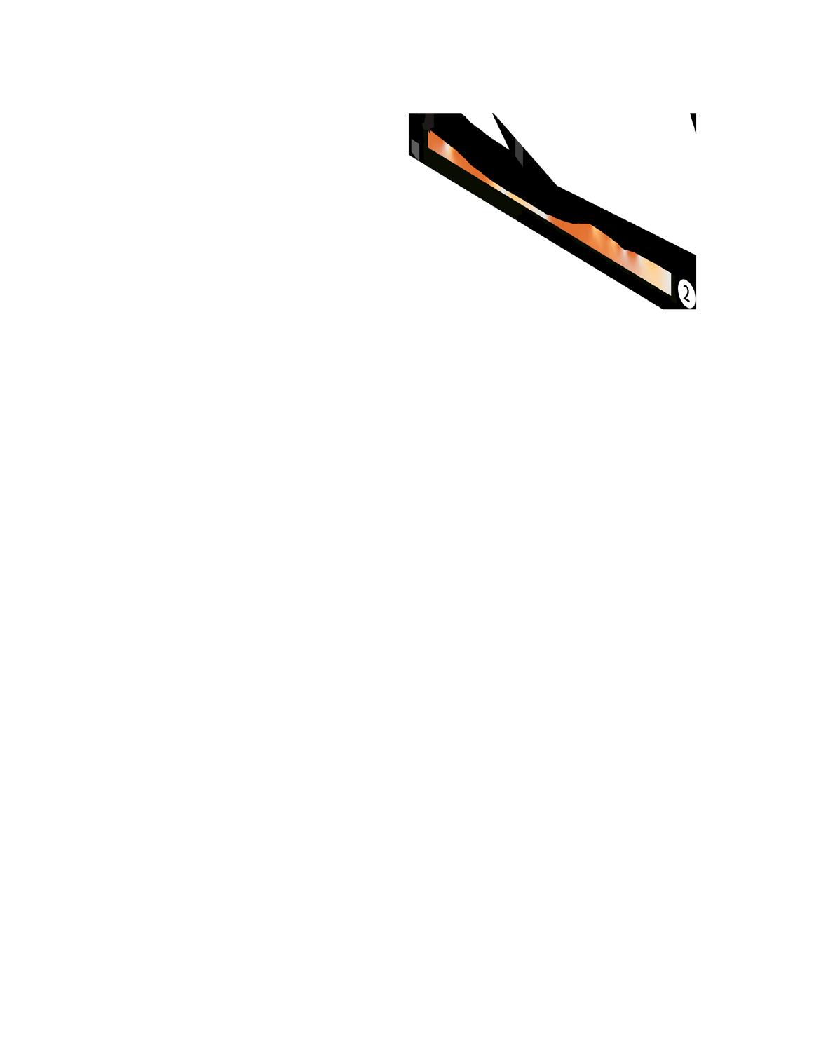


Navigational Challenges
The park is hard to navigate while fully sighted, but people with visual impairments would have added challenges walking through the park. Blindness is a spectrum and visual cues can help most people (Kleck, 2024). These stairs lack necessary contrast lines. And there are no tactile guides along the paths. Unlevel surfaces also present tripping hazards.


Fully Sighted
Cataracts
Cortical/Cerebral Visual Impairment
Macular Degeneration Glaucoma
Design Opportunities
Key Insights
There are many possible interventions to make McMinnville City park safer and easier to navigate for everyone.
• Simple fences with top rails or rope would discourage people from climbing through the brush while providing a tactile line for navigation with limited sight.
• Include accessible pathways where possible (minimum one path across the park) and lookouts over the lower park
• Pathways that weave back and forth across the steep slopes would provide an accessible route to the lower park .
• Accessible pathways would improve park navigation for everyone and make it possible for more people to use the space.
• Lookouts would also put eyes on the lower park.

People with cognitive disabilities need more graphic information displayed throughout the park.


Priority Area for Accessibility Upgrades
Possible Lookout Areas
Possible Sensory Garden
Primary Path

Trail at the North River Wildlife Sanctuary
Lookout at the New Forest National Park in England
People Fall Through Holes
People Experiencing Homelessness - Point in Time Count in McMinnville, OR
January 29th, 2020
Precariously Housed
2.6% of the McMinnville population was on the edge of literal homelessness in 2020.
1.5% were actively experiencing homelessness.
Point in time counts paused for years due to the pandemic.
“Precariously housed” means couch surfing or living “doubled up.” It’s a gray area between housed and homeless.
Seeking
There are many reasons people may either be uncomfortable or unable to sleep in a shelter. It’s hard to know anyone’s individual circumstances, but there’s a reason people have ended up sleeping in the park.
We need to find a solution that shows compassion for all users but recognizes that a park can’t patch the holes people in need fall through.
We need to balance welcoming everyone with creating a safe environment in the park.


Key Insights
• Ensure the park has at least one accessible path to include the full spectrum of mobile ability.
• Incorporate clear signage throughout the park to improve navigation for users with cognitive disabilities.
• Connections with local history can be added within the park, such as a native land acknowledgement.
• Enhanced park programming can promote physical exercise, mental well-being, and stress relief.
• Utilization of CPTED principles and better lighting design can reduce crime and deter unwanted behaviors.


Research Questions
EN1:“How could this site facilitate greater habitat connectivity to wildlife corridors?
EN2: “How can greater connectivity support wildlife diversity?”
-Rachel Benbrook

EN3a-3b: “How do the creek and floodplain influence the site? What are the opportunities for activation?
-Clark Frauenglass
EN4a-4b: “How might the site be understood in terms of biomes in both plan and section?”
What are the programmatic constraints of working within a regulatory floodplain?
-Liam Sobie
EN5: “What is the baseline health of City Park on a site and city scale?”
EN6: “How can we determine the extent of the tree canopy at City Park?”
EN6: “How can we determine the value of trees on site based on quantifiable characteristics?”
-Cassandra Lanson
Research Question
How could this site facilitate greater habitat connectivity to wildlife corridors? How can greater connectivity support wildlife diversity?
Geoprocessing
Reclassification, Weighted Overlay
Data Sources
Oregon Department of Fish & Wildlife, Oregon
Conservation Strategy, Oregon Biodiversity Information Center, Multi-Resolution Land Characteristics
Consortium

Literature
A. Gastón, S. Blázquez-Cabrera, C Ciudad, Mateo-Sánchez, M. C., Simón, M. A., & Saura, S. (2019). The role of forest canopy cover in habitat selection: insights from the Iberian lynx. European Journal of Wildlife Research, 65(2). https://doi.org/10.1007/s10344-019-1266-6
Arnold, C. L., & Gibbons, C. J. (1996). Impervious Surface Coverage: The Emergence of a Key Environmental Indicator. Journal of the American Planning Association, 62(2), 243–258. https:// doi.org/10.1080/01944369608975688
LaPoint, S., Niko Balkenhol, Hale, J., Sadler, J., & Rodney. (2015). Ecological connectivity research in urban areas. Functional Ecology, 29(7), 868–878. https://doi.org/10.1111/1365-2435.12489
Oregon Agriculture Natural Disaster Briefing Paper. (2021). https://www.oregon.gov/oda/AboutUs/ Documents/Board%20of%20Agriculture/09-21/OFB_Oregon%20Agriculture%20Natural%20 Disaster%20Briefing%20Paper%209.13.pdf
Professors explain the social cost of carbon. (2021). Stanford.edu; Stanford University. https://news. stanford.edu/stories/2021/06/professors-explain-social-cost-carbon#:~:text=The%20short%20 answer%3A%20When%20calculating,human%20health%20and%20labor%20productivity.
Rathert, D., White, D., Sifneos, J. C., & Hughes, R. M. (1999). Environmental correlates of species richness for native freshwater fish in Oregon, U.S.A. Journal of Biogeography, 26(2), 257–273. https://doi.org/10.1046/j.1365-2699.1999.00274.x
Resasco, J., Haddad, N. M., Orrock, J. L., Shoemaker, D., Brudvig, L. A., Damschen, E. I., Tewksbury, J. J., & Levey, D. J. (2014). Landscape corridors can increase invasion by an exotic species and reduce diversity of native species. Ecology, 95(8), 2033–2039. https://doi.org/10.1890/140169.1
S. Braaker, Moretti, M., Boesch, R., J. Ghazoul, Obrist, M. K., & F. Bontadina. (2014). Assessing habitat connectivity for ground‐dwelling animals in an urban environment. Ecological Applications, 24(7), 1583–1595. https://doi.org/10.1890/13-1088.1
Salviano, I. R., Gardon, F. R., & Santos. (2021). Ecological corridors and landscape planning: a model to select priority areas for connectivity maintenance. Landscape Ecology, 36(11), 3311–3328. https://doi.org/10.1007/s10980-021-01305-8
Willamette Valley Ecoregion
Most Urban Ecoregion in Oregon
The Oregon Conservation Strategy defines ecoregions as “portions of the state with similar climate and vegetation.” (Oregon Conservation Strategy, 2024)
Cupped by the Coastal Range to the west and the Cascade Range to the east, the Willamette Valley is the most urban out of Oregon’s ecoregions. Roads and other development create barriers to wildlife movement.
Habitat fragmentation is a major concern for conservation.
Movement through connected areas enhances biodiversity by providing access to resources, recolonization of patches where populations have disappeared, and increased genetic diversity. Connectivity provides more flexibility for species to respond to changing conditions like climate change. Well connected populations are more resilient to disturbances. (Beckman et al., 2010)
Protecting endangered species and cultivating biodiversity ensures that wildlife and natural areas are maintained. Beyond the ecosystem services provided, this can also benefit industries that can take advantage of pristine and diverse natural areas, like tourism.

Oregon Conservation Strategy Ecoregions

Habitat Loss in the Willamette Valley Past vs. Present
Prior to colonizanition in the latter part of the 1800’s, riparian forest, open prairie, and oak savannah dominated the valley floor. Today, less than 10% of these historic habitat range remains.

Developed for Human Use
Prairie
Shrubland
Oak Savannah
Wetlands
Open Water
Mixed Woodland
Upland Conifer Forest
Riparian Forest
Rachel Benbrook / REIMAGINING McMINNVILLE CITY PARK
Oregon Biodiversity Information Center, Portland State University, ODFW, 2015
GLO Surveys 1850-1910, ODSL, Oregon Community Foundation, EPA, City of Portland Bureau of Environmental Services, ODFW, USDA Forest Service, The Nature Conservancy, Metro, Lower Columbia River Estuary Program

Rare & Common Oregon Wildlife Potential Users
These species have been identified as potential users of a habitat site like McMinnville City Park. because of their range and habitat requirements. Species highlighted with a dark circle are listed as Oregon Conservation Strategy Species. These species are important native species that are considered threatened or endangered.
Black-tailed Deer Odocoileus hemionus
American Beaver Castor canadensis
Western Bluebird Sialia mexicana
Raccoon Procyon lotor
Western Painted Turtle Chrysemys picta
Garter Snake Thamnophis sirtalis
Northern Red-legged Frog Rana aurora
Camas Pocket Gopher Thomomys bulbivorus
Yellow Warbler Setophaga petechia
Western Gray Squirrel Sciurus griseus
Gray Fox
Urocyon cinereoargenteus
Red-shouldered Hawk Buteo lineatus
White-breasted Nuthatch Sitta carolinensis
$8.9 billion in damages related to the Pacific Northwest heatdome in 2021
Costs of a Damaged Biosphere
Value of Ecosystem Services
Why does biodiversity matter? Beyond the aesthetic and moral value of preserving the environment, the services an ecosystem provides can be economically fruitful.
$19 billion in costs related to wildfires in the US in 2020
$4.3 billion in costs related to water pollution in the US annually
$34.7 billion spent on healthcare in Oregon in 2022
Biodiverse ecosystems are more healthy, and therefore store more carbon and are more effective at helping regulate the climate, which can mitigate costs associated with wildfires, agricultural loss, and damages from excess heat or severe storms.
Healthy ecosystems are more attractive and inviting, bringing more tourism, which is an industry that is critical to the economy of McMinnville.
Healthy ecosystems are more effective at filtering water and capturing runoff, reducing the costs of filtering drinking water, managing stormwater, and repairing flood damage. Clean water is also integral for productive fisheries.
Healthy ecosystems impart health benefits to the surrounding community, reducing public costs for medical care and facilities.
Protecting and nurturing biodiverse ecosystems is a preventative strategy to avoid incurring greater costs down the road.

Priority Wildlife Conservation Areas Habitat Networks
The Oregon Connectivity Assessment and Mapping Project analyzes and identifies existing wildlife habitat connectivity throughout the state for a wide diversity of species. McMinnville is positioned directly between two connectivity areas.

Regions are areas identified as the highest value habitat for facilitating species movement. These areas are large and contiguous, high quality and relatively undisturbed. (OCS, 2022)
Connectors are optimal pathways between Regions. Connectors may pass through undisturbed habitat as well has the best remaining marginal habitat in developed or degraded areas. (OCS, 2022)
Steppingstones are remnant areas of habitat in otherwise developed landscapes. These areas can act as refuges, allowing species to reach other areas. (Saura et al., 2013)
McMinnville City Limit City Park
What makes a good habitat corridor?
Shelter, Water, Food
City Park’s location and proximity to other open green areas could be an opportunity to expand habitat connectivity through McMinnville. We examined several factors determine City Park’s suitability as a habitat corridor.
Assessment Factors:
Habitat Type
Fish Access
Tree Canopy
Permeable Surface Area
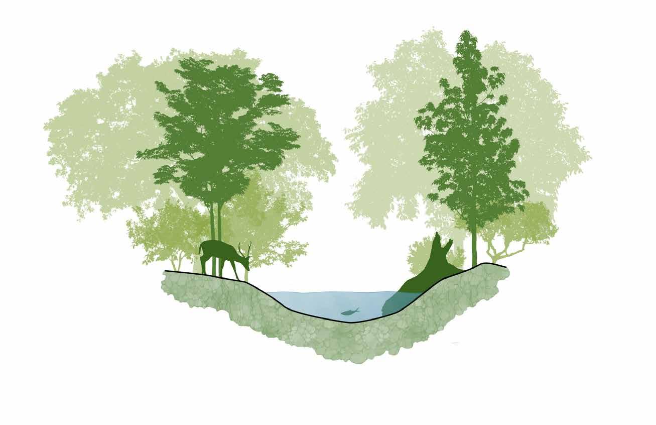
Tree Canopy
Riparian Area with gentle banks
Pervious Surface
Slow moving water connected to other channels without obstructions
Habitats in McMinnville
Riparian Area in City Park
Riparian areas are one of the most suitable habitat types to prioritize for ecological corridors. Riparian areas are typically less threatened by encroaching development because of inconsistent water levels and their valuable ability to filter stormwater.
The streams and rivers running through riparian areas are already natural pathways through the landscape, enforcing connectivity.


Barriers to
Flow of Water Fish Access
the
Fish Passage is a key indicator of habitat connectivity. If stream networks are disconnected, it is likely there are also barriers for terrestrial species.
In the US, aquatic species are the most threatened species group. Without access to a connected network of streams and water bodies, it is impossible for fish to colonize different areas and grow their populations. Many species depend on connected streams and high-quality habitat to survive. Removing obsolete barriers to fish passage can eliminate flooding hazards, improve climate reslience, and restore river ecosystems.
McMinnville is essentially a desert for fish, despite having several forks of Cozine Creek running through town towards the Yamhill River.
What is a barrier?
A barrier is anything that prevents or reduces the ability of aquatic species to move to different areas. (US Fish & WIldlife Service, 2024)
Types of Barriers
• Culverts
• Dams
• Levees
• Increased Sediment
• Abnormal Fluctuations of Water Temperature
• Water Diversions
• Extremely High or Low Water Velocity
• Poor Water Quality
Shelter, Shade, Food Tree Canopy
Parks, gardens, and yards are important structural components of urban habitat connectivity.
Tree canopy is an important indicator of habitat usefulness for woodland species.
Trees provide homes for small prey animals and birds, cover from predators, and often trees are important food sources. Tree cover also creates shade, keeping temperatures down for aquatic and terrestrial species, an important resource during high temperatures made more frequent by climate change.

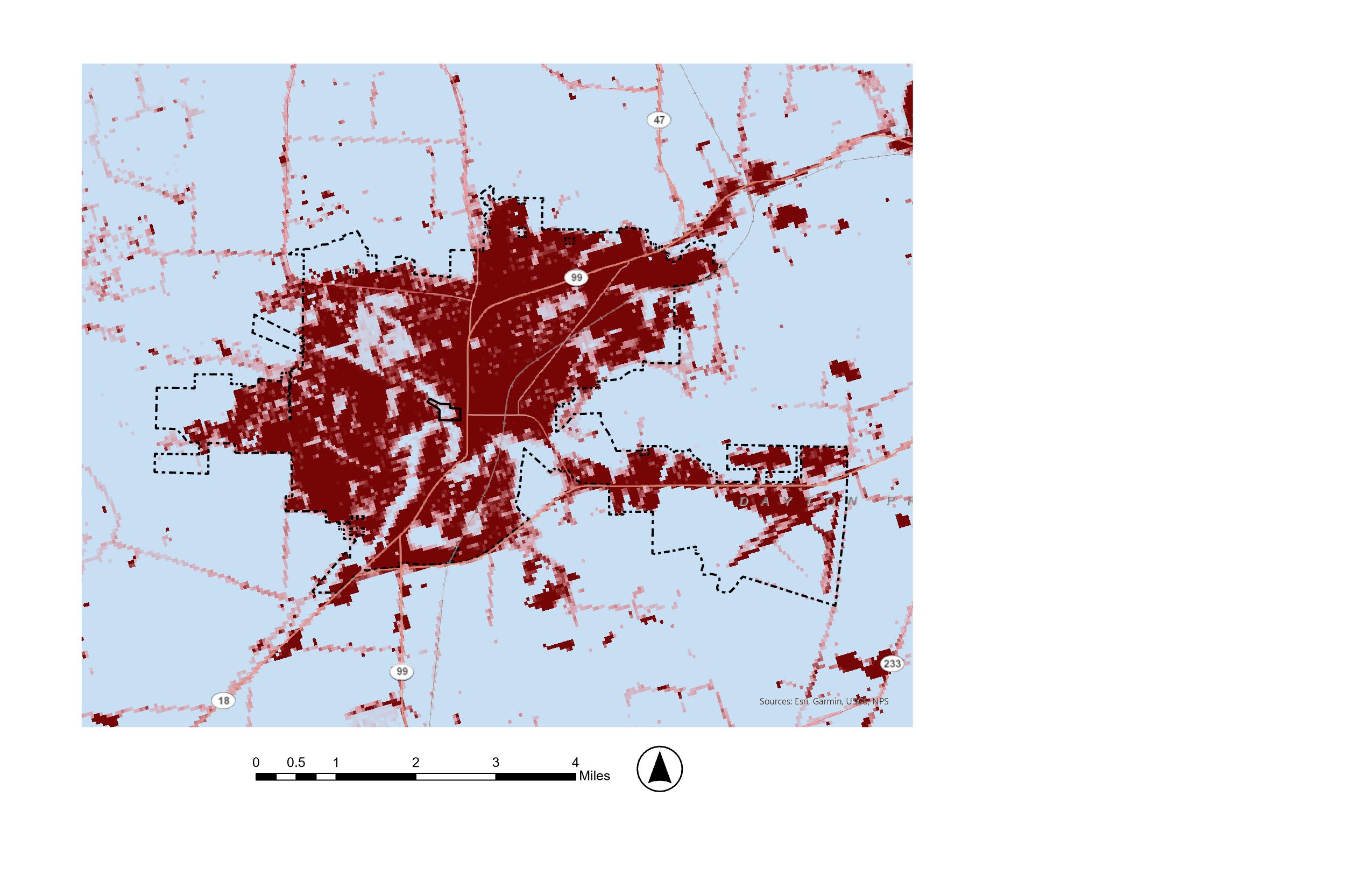
McMinnville
Soil vs. Concrete Surface Permeability
Surface permeability is a useful indicator of urban habitat quality. Highly developed areas will naturally have less available plant material. Percentage of impermeable surface has direct impacts on water quality and stormwater runoff for local streams and drainage networks. The more impermeable surface area, the more stormwater accumulates instead of naturally soaking into the earth. This leads to increased water velocity, which increases erosion. Runoff causes elevated water temperatures, as black asphalt roads warm precipitation before it runs off. Runoff includes heavy metals, rubber particles, oil, engine fliuds, and other pollutants, reducing water quality. Excess runoff is taxing to civil storm systems, increasing maintenance costs.
When storm runoff can flow into planted areas, it can be filtered and cooled by plants and soil before returning to waterways.
Analysis
Reclassify & Overlay Habitat Factors
Each factor map is made of values that correspond to features that map is depicting. These feature values were reclassified on a scale of 1-3, least suitable to most suitable.
The Habitats map was reclassified assuming riparian areas would be most suitable (1), all other natural habitats areas medium suitable (2), and developed areas least suitable (3).
The Fish Access map was reclassified with areas that have the highest flow potential as most suitable (1), medium flow as medium suitable (2), and slow or no flow areas as unsuitable (3).
The Tree Canopy map was reclassifed with areas with the most tree cover (+70%) as most suitable (1), medium tree cover (20-70%) was medium suitable (2), and little or no tree cover (0-20%) as unsuitable (3).
The Surface Permeability map was reclassified as areas with more than 70% permeability as most suitable (1), areas with 30-70% permeability as medium suitability (2), and areas with less than 30% permeability as unsuitable (3).


Identifying Potential Steppingstones Habitat Suitability
The reclassified factor maps were combined in a weighted overlay to produce a suitability map (top).
When overlaid with the previous Priority Wildlife Connectivity Areas map from page 8 (below), City Park’s potential as a stepping stone between important habitat regions and connectors is clear.


Yamhill River Habitat Region
Yamhill Oaks Habitat Connector
City Park as a Steppingstone
Possible Travel Corridors

Research Question
How do the creek and the floodplain influence the site? What are the opportunities for activation?
Geoprocessing
Select by location
Data Sources
USGS National Map Viewer, Fema Flood Hazard Maps, on
site water quality testing, City of McMinnville, GIS, Esri
Database


Literature
Angier, M., Delima, T., Hopkins, H., Hulsman, L., Leis, J., Musser, M. K., Prodzinski, J., Ramos, C., & Wan, J. (n.d.). Examining water quality and vegetation along cozine creek senior capstone ENVS 460: Fall 2020. Retrieved October 16, 2024, from https://www.linfield.edu/assets/files/envs/Cozine-Creek-Water-Quality_Fall-2020-FINAL.pdf
Counties, P. (n.d.). Lower Yamhill Watershed Assessment. gywc.org. https://gywc.org/wp-content/uploads/2021/03/Lower-Yamhill-River-Watershed-Assessment.pdf
Greater Yamhill Watershed Council. (2024). Strategic action plan. Greater Yamhill Watershed Council. https://gywc.org
Neale, M. W., & Moffett, E. R. (2016). Re-engineering buried urban streams: Daylighting results in rapid changes in stream invertebrate communities. Ecological Engineering, 87, 175–184.
Nguyen, H., Radhakrishnan, M., Huynh, T. T. N., Baino-Salingay, M. L., Ho, L., Steen, P., & Pathirana, A. (2017). Water quality dynamics of urban water bodies during flooding in Can Tho city, Vietnam. Water, 9, 260.
Tillamook Estuaries Partnership (Director). (2021, August 17). Removing Barriers: Converting Culverts to Bridges for People & Wildlife [Video recording]. https://www.youtube.com/watch?v=ps0tY805Bzk
Yamhill watershed
The Big Picture
• The city of McMinnville is located in the Greater Yamhill River Basin, one of the largest watersheds in the Willamette River Valley.
• The city limits straddle both North Yamhill Watershed, and the Lower Yamhill Watershed.
• Most of the city, including our site, is situated in the Cozine Creek/ South Yamhill sub-watershed.
• The watershed is managed by the Greater Yamhill Watershed Council (GYWC).


Cozine Creek
Fragmented by Culverts
• Undersized, damaged, and aging culverts can limit access to important stream habitat for fish and other aquatic organisms
• Catastrophic failure can seriously impact the road above, cutting off people from emergency services and egress routes.
• Replacing a culvert with a larger, more suitable structure like a bridge is a win-win for fish, water quality, transportation, and the economy.
“Ultimately a bridge is going to provide the most area for passage, the most clearance over a stream, to provide biological benefit.”
- David Harris, Tillamook Estuaries Project, 2021
3 ECOLOGICAL NETWORK
City Park
An Isolated Island
The North Branch of Cozine Creek enters and exits the park through narrow culverts (24” diameter on the north end and 36” on south).
Culverts create a wide variety of problems for fish trying to swim upstream, and they also block access for other wildlife as well, forcing them to access the park by crossing busy roads effectively cutting off this area of potential habitat from most users.


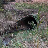


Barriers to Fish
The problem with culverts

Culvert blocks fish access
Road blocks wildlife access
Annual Flooding
Opportunities and Constraints
Floods create temporary opportunities for recreation
Severe constraints on built infrastructure and planting design.
Flooding within the regulatory floodway submerges existing infrastructure.
Regulatory Floodway
Allows space for Cozine Creek to spill out of its regular channel durring periods of winter rain.
Culverts create a bottleneck, creating a lingering pond up to 15 feet deep in places.
Insufficient Infrastructure
Infrastruture and amenties are not geared toward the level of flooding experianced by the site.
Paths, picnic tables and shelters are innundated, rendering them innaccesible to most park users.
Amenities are vulnerable to damage from flooding events leading to safety concerns even after the water has subsided.


Formalizing Informal Uses

“It floods every year! We’ve even seen people kayaking
out there!”

• It’s exciting to imagine what it might look like to embrace and formalize unsanctioned uses engaged in by local residents and urban adventurers.
• Urban kayaking is an ephmeral winter recreation activity that could draw more users to the park durring the off season.
• A reloctaed picnic shelter could serve as a pop-up renatal kiosk to check out paddling equipment.
• The library could facilitate lessons and workshops on water saftey and flash flood safety.
Kayaker enjoying a paddle through City Park
Clark Frauenglass / REIMAGINING McMINNVILLE’S
Water Quality
Marginal Habitat
Cozine Creek was once salmon spawning habitat. Young salmonoids require specific environmental conditions in order to survive and thrive.
The desired water quaility standards set forth by the Greater Yamhill Watershed Council includue a pH of 6.5-8.5, an average temp below 18 °C, and a dissolved oxygen content no less than 8.0 mg/L.
Water quality samples collected on site on 10/18/2024 are listed below.
Dissolved Oxygen –Nitrate –
Temperature –Electrical Conductivity –pH –
7.7 mg/L
2.76 mg/L 12.8 °C
764 µS/cm 7.3
These samples were compared to data from a long term water quality monitoring study conducted by students at Linfield University to produce the graph on the next page.


Indicator Species
What’s Bad For The Salmon is Bad For Us Too


Problems identified by the GYWC
• Water temperatures in the summer and early fall exceed what is healthy for fish and other organisms.
• Naturally low water flows in the summer and early fall, exacerbated by water withdrawals from agricultural, municipal, and other uses.
• Road stream crossings, and permanent and seasonal dams can be barriers to fish movement
• Contaminated water from poor urban stormwater management and runoff from inadequately maintained roads and other land use practices contribute to poor water quality.
• Reduced large wood in streams, limits on width and quality of stream-side vegetation, and disconnected floodplains, contribute to low-quality habitat
Riparian Vegetation
Native Non-Native Invasive


A Picture of Neglect
Plants fond on site are characteristic of disturbed and degraded riparian ecosystems throughout the Willamette Valley. Some particularly concerning species are Yellow Flag (Iris pseudacorus) and Water
Primrose (Ludwigia spp.). Both spread monotypically crowding out other aquatic plants, and water primrose forms dense mats, slowing or even stopping the flow of water.
Acer circinatum
Acer macrophyllum
Alnus rhombifolia
Chamaecyparis lawsoniana
Corylus cornuta v. californica
Fraxinus latifolia
Polystichum munitum
Prunus avium
Pseudotsuga menziesii
Rubus ursinus Salix spp.
Symphoricarpus albus
Aesculus hippocastanum
Betula spp.
Populus spp.
Acer platanoides
Ailanthus altissima
Crataegus mongyna
Hedra helix
Iris pseudacorus
Ludwigia spp.
Melissa officinalis
Phalaris arundinacea
Rubus armeniacus
Rununculus repens
Solanum dulcamara
Equisetum spp.
Hypericum calycinum

Research Question
How might the site be understood in terms of “biomes” in both plan and section? What are the programmatic constraints of working within a “regulatory floodplain”?
Geoprocessing
DEM, Slope, Aspect, Hill shade, SSURGO Soils
Data Sources
USDA Web Soil Survey, NOAA LIDAR


https://www.ecfr.gov/current/title-44/chapter-I/subchapter-B/part-60/subpart-A/section-60.3
https://www.fema.gov/sites/default/files/2020-07/fema_ tb_2_flood_damage-resistant_materials_requirements. pdf https://www.nature.com/articles/s41467-020-19188-9
https://www.sciencedirect.com/science/article/abs/pii/ S0022169417301373?via%3Dihub
https://www.sciencedirect.com/science/article/pii/ S0013935117316602?via%3Dihub#f0005
Site Biomes
Based on Observations
During the site visit, we observed McMinnville City Park and took note of the characteristics in each area of the site. From this data, we will be able to determine problem areas and later designate certain places for redevelopment.
Zoning Criteria:


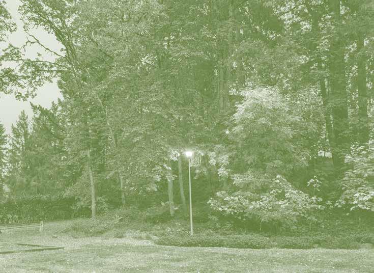


Biome Realignment
Observations and GIS data


Suitability Insights
Synthesis of data
edge 3.9 25%
Hosts pickleball courts and play structure, lots of flat open area, and densely forested hilly areas.
Potential reimagination area near pickleball area. Lower city park 1.1 7%
Lots of unused space, mostly filled with conifers with little ground cover.
Lots of open spaces, benches, and covered areas. Some wooded areas.
Potential reimagination area, would require removal of trees for structures.
Potential reimagination area, no structures for flood, good for designed planting.
Unlikely reimagination zone due to dense planting and steep slope
Lots of open area, library, aquatic center, dragon park Potential reimagination area, lots of space to build and plant in.
City Park has many areas with heavy ground and
City Park has a lot of spaces that could be transformed by social/ecological/spatial interventions.

Current site Site Model


4 Design Precedents

Research Questions

Research Question
DP1a-1b:“How might we repurpose the material from the dragon playground and give it new life?
How can we respect the community who built and designed the playground?”
How can we repurpose the material from the dragron playground and give it a new life
-Macie Kelley
How can we respect the community who built and designed the playground?
Research Question
EN2a-2b: “What are the key principles of a successful nature play area?”
What are the key principles of a successful nature play area?
EN3: “Where are the areas throughout the site that might be suitable for new play/active areas given their slope, aspect, and soils?”
-Minh Nguyen
Where are the area throughout the site that might be suitable for new plays/ active area given their slope/aspect/soil?


Dragon Playground
The large playground at City Park is known as “Dragon Playground”. This 10,000 square foot park was built in the 1970’s by the people of McMinnville. To remember these individuals who participated in the building and funding of the park their names were memorialized on the fence around the perimeter of the playground.


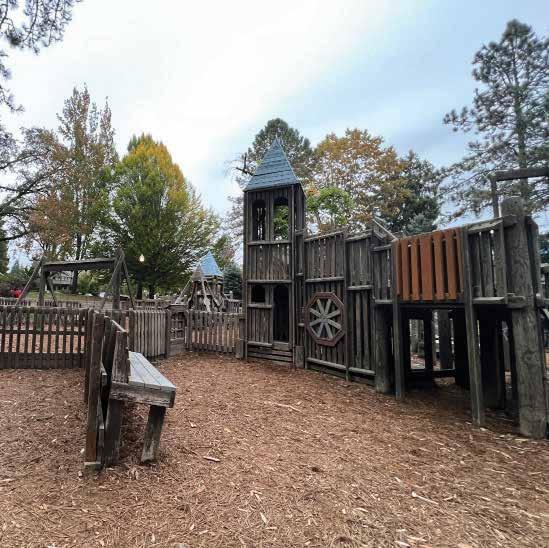
Current Conditions
Wear and tear
The play structure has lost some of the original equipment and these features have not been replaced. Major areas made by missing equipment that pose safety risks have been patched up by wood, but other small missing parts are left missing.


Recycling
How can we save the timber?
To reduce the hazards of the creosote treated timber the wood needs to be either sealed with a stain or a paint. This will help contain the chemical and prevent it from spreading into the surrounding environment. Sealing the wood will allow us to reuse the timber and create a new feature for City Park.
Dragon Playground
Reduce Hazards
Reuse Timber
Recycle Material


Project: Breaker
By: Adam Kuby
Location: Aberdeen Washington
Description: *Breaker*, by artist Adam Kuby, is a striking public art installation that features salvaged large basalt stones arranged to evoke the image of waves breaking along a shoreline. Installed along the Columbia River in Vancouver, Washington, the piece reflects the power and movement of water, inviting viewers to contemplate the relationship between natural forces and the urban environment.


Project: Capturing Resonance
Location:
Description: “In Capturing Resonance, Park and Topel have fused visual and sonic elements in a sensorial environment that captures the dynamic interactions between light, sound, and human presence. Transforming an already architecturally in-between space, Park and Topel filter the non-physical conditions of the site – light and movement – through sculptural and aural forms.

Project:


Project: Pergola in Luotuowan Village
Location: Hebei, China
Description: The LUO studio constructed a pergola in a renovated Chinese village using leftover materials from the renovation process, showcasing sustainable building practices. This thoughtful structure provides locals with a shaded gathering space, blending traditional aesthetics with resourceful design.
Project: Treedom
Location:
Description: Tanabe Chikuunsai IV’s Recycled Bamboo Installations* are intricate, sitespecific sculptures made from inter woven bamboo, creating dynamic, organic forms that respond to their surroundings. These installations, crafted from recycled bamboo, highlight traditional Japanese weaving techniques while emphasizing sustainability and the beauty of natural materials.


Location: 2015 Sziget Festival in Budapest
Description: Treedom by Atelier YokYok, in partnership with Sammode, is an enchanting light installation that transforms outdoor spaces with tree-inspired structures that glow from within. These artistic, tree-like forms are equipped with integrated lighting, creating a magical environment that invites people to gather and experience a whimsical blend of art and nature.
Project: The Re-Emerge Pavilion
Location: Bedford Square, London 2021
Description: The Re-Emerge Pavilion, designed by EmTech/AA in collaboration with Hassell, is an innovative structure that uses advanced digital fabrication and sustainable materials to create a responsive, shelter-like space. Its organic form and modular construction reflect a focus on adaptability and resilience, offering a glimpse into the future of ecofriendly architecture.
By: Spencer Topel
By: Tanabe Chikuunsai IV
By: EmTech/AA and Hassell
By: Atelier YokYok and Sammode
By: LUO Studio
(deconstruct)

(inventory + treat) (reconfigure)


Research Question
What are the key principles of a successful nature play area?
Where are the area throughout the site that might be suitable for new plays/ active area given their slope/aspect/soil?
Geoprocessing
Slope, Aspect, Polygon to Raster, Reclassify, Weighted Overlay
Data Sources
Fjørtoft, Ingunn & Sageie, Jostein. (2000). The natural environment as a playground for children: Landscape description and analyses of a natural playscape. Landscape and Urban Planning. 83-97.
Betti, G., Tartarini, F., Nguyen, C, Schiavon, S. CBE Clima Tool: A free and open-source web application for climate analysis tailored to sustainable building design. Build. Simul. (2023). https://doi.org/10.1007/s12273-023-1090-5. Version: 0.8.17

Literature
Betti, G., Tartarini, F., Nguyen, C, Schiavon, S. CBE Clima Tool: A free and open-source web application for climate analysis tailored to sustainable building design. Build. Simul. (2023). https://doi.org/10.1007/s12273-023-1090-5. Version: 0.8.17
Zuo, Kaidi & Wei, Lihua & Cong, Yanguo. (2020). Exploration of Natural Playgrounds in Urban Parks: Promoting Children’s Health. Urban and Regional Planning. 5. 122. 10.11648/j.urp.20200504.14.
Smith, S. J. (1998). Risk and our pedagogical relation to children: On the playground and beyond. New York, USA: State University of New York Press.
Pirkko, H., & Marjaana, K. (2007). From bogey mountains to funny houses: Children’s desires for play environment. Australian Journal of Early Childhood, 32 (3), 39-47.
Sargisson, R. J., & Mclean, I. G. (2012). Children’s use of nature in New Zealand playgrounds. Children, Youth & Environments, 22 (2), 144-163.
Appleton, J. (1996). The experience of landscape. New York, USA: John Wiley.
Moore, R. C., & Cosco, N. G. (2007). What makes a park nclusive and universally designed? A multi-method approach. In C. W. Thompson, & P. Travlou (Eds.), Open space: People space (pp. 85-110). London, UK: Taylor & Francis.
Bao, L. Q. (2013). Naturalizing design of children’s outdoor playgrounds. Journal of Chinese Urban Forestry, 11 (3), 38-40.
Fjørtoft, Ingunn & Sageie, Jostein. (2000). The natural environment as a playground for children: Landscape description and analyses of a natural playscape. Landscape and Urban Planning. 83-97.
Current Playground: Traditional Playground
Tradtional Playground vs Ecological-Based Playground
The current playground is a traditional playground, typical of 19th-century park playground design. There are benefits in traditional design playgrounds that offer unique developmental benefits. However, as more research on child psychology and motor development has been done, natural playgrounds (also known as ecological-based playgrounds) have been proven to provide better results for well-rounded children’s development. Therefore, as the park proposes a new playground, we believe that creating an ecologicalbased playground that uses natural play and area topography will benefit communities more positively than recreating a modern traditional playground as a replacement.
Traditional facilities tell children what and how to play, while natural playgrounds usually provide more open spaces. They use terrain and vegetation to stimulate and create opportunities for spontaneous interaction and different types of play. They are also designed for more physical challenges than traditional playgrounds. Children’s acceptance of natural playgrounds is higher than conventional playgrounds. The patterned equipment in traditional playgrounds limited children’s nature of free running and creative play, as the natural playground was created against those principles. With a deepening understanding of the positive role of nature play, designers began to attach important factors to children’s playgrounds and developed a further concept of “ natural playgrounds.”

Definition of Natural Play on Natural Playground
What are different benefits that natural play can contribute on children overall health?
Researchers have given multiple interpretations of the concept of natural play, from the broad to the narrow. Most interpretations concentrate on the theoretical perspective of how it correlates to children’s psychology when children spend more time in nature. Over time, the theory started to be applied to design principles as people desired an effective playground for their community.
Many theories show that nature play brings many physiological, psychological, cognitive, and social benefits to human beings. Nature has become the top priority for children as it is considered the” perfect park” due to its positive impact on children’s health. The Children & Nature Network organization defines “nature play” as outdoor free play in natural areas. It combines children’s experiences of happiness and self-guidance in natural places with imagination, constructive play, rich senses, and cooperation.
Source: Zuo, Kaidi & Wei, Lihua & Cong, Yanguo. (2020). Exploration of Natural Playgrounds in Urban Parks: Promoting Children’s Health. Urban and Regional Planning. 5. 122. 10.11648/j.urp.20200504.14.
Figure 1: Diagram indicate the interpretation of “Natural” and “Play” in Landscape Desgin
Landscape Ecology Interpretation
Understand the benefit of natural play, how can different topography elements provide different benefits on children development?
Well-designed natural playspaces can support the development of physical and movement skills in children, including fitness, endurance, coordination, and fine motor control. Natural environments that have dynamic and rough landscapes that challenge can help to improve motor activities in children. Intuitively, children will use their surround environment for physical challenges and play - therefore, they will perceive functions of the landscape toppgraphy and use them for play appropriately. By altering the natural playground to fit with site effective topography, designer can effectively produce ecological based playground that can achieve high-level of motor fitness. Moreover, understanding the environmental features and conditions of playspaces that can prompt and scaffold high-quality play experiences can help inform children’s (re)design of stimulating, health-promoting playscapes.


Active moving on rough grounds or natural elements such as climbing tree and jumping rock enhance children motor fitness. Loose parts (natural or man-made)with no instructions can be incoporated through repurposed. Open-ended materials can be moved, combined and stacked together through children’s creativity.

Open ground (flat, relatively smooth surface) create opportunities for running, walking and creative games.


Playing area with “cliffs” and edges of different height encourage positive “risky play” that can enhance children risk-assessments abilities by pushing themselves out of their comfort zone.


Sloping terrains provide affordances for rolling, sliding, and clambering.. Implement slope in playground enhance children level of physical activities.
Case Study: Precdents of Different Type of Nature Plays
Precedents Research


Design Consideration for Natural Playground

Correlation Between Design Consideration and Children’s Need
Children’s Favorite Elementes in Play and Design Consideration
Figure 2: Table display correlation between children’s preffered element and design consideration.
Source: Zuo, Kaidi & Wei, Lihua & Cong, Yanguo. (2020). Exploration of Natural Playgrounds in Urban Parks: Promoting Children’s Health. Urban and Regional Planning. 5. 122. 10.11648/j.urp.20200504.14.

Summary Diagram: Proposed Playground

Pre-Analysis: Data Research
Before the analysis, various data were collected to understand the site context and climate, which can be categorized under slope, aspect, and soil map. There are many different types of natural playgrounds, and each has different standards to succeed. For this research, we will generalize average data for each category to find what average topography can affordance a versatile natural playground. By assessing different research papers and standard conditions for successful natural playgrounds, all of the values for successful general natural playgrounds will be used during the reclassified process in ArcGis.

Natural Playground Characteristics Related to Landscape Characteristics


Soil Rating Map for Public Park in McMinville
Sun Diagram for McMinville Area
Source: Soil Surrvey Geographic Database (SURRGO)
Source: Fjørtoft, Ingunn & Sageie, Jostein. (2000). The natural environment as a playground for children: Landscape description and analyses of a natural playscape. Landscape and Urban Planning. 83-97.
Source: Betti, G., Tartarini, F., Nguyen, C, Schiavon, S. CBE Clima Tool: A free and open-source web application for climate analysis tailored to sustainable building design. Build. Simul. (2023). https://doi.org/10.1007/s12273-023-1090-5. Version: 0.8.17
Land Analysis
Reclassify and Overlay Topography
The site was analyzed through ArcGis, focusing on slope, aspect, and soil map. The main objective was to find and evaluate topography for which area is the best candidate for future natural playgrounds by rating landscape affordances for versatile play.
• Slope was reclassified based on these criteria:
• 1: 3% - 8% - Highly affordance for many natural play activities and path
• 2: 9%- 18% - Good to low affordances as not many play activities cannot be applied
• 3: 18%-38% - Hardly to no affordance
• Soil map was reclassified based on these criteria:
• 1: Not limited - highly suitable for many design uses in natural playgrounds ( along with enduring a good amount of foot traffic)
• 2: Somewhat limited - medium suitability as it could still be used but not to its full potential and low likelihood of hazard
• 3: Very limited - no suitability as it is low-quality play uses and highly dangerous
• Aspect was reclassified based on these criteria:
• 1: Suitable - Received high amount of sunlight or flat area
• 2: Somewhat suitable - Low to moderate amount of sunlight
• 3: Not suitable - No sunlight

Suitability Analysis
Choosing suitable area for natural playground

Suitability analysis: area evaluation


Project: Colegio Maya
By: Learning Landscapes
Location: Guatamala City, Guatamala
Description: This playground showcases various nature play themes while considering the diverse community and its needs. This park is grouped into multiple sections including: a sensory play zone with sand, water and childrens garden, a play building zone with platforms and loose pieces, a large motor activity zone with forts, log climbing, ropes and multiple slides.


Project: Oxbow Adventure
By: Learning Landscapes
Location: Gresham, Oregon
Description: This park explores nature themes in a controlled and safe environment. Oxbow adventure park has multiple different areas of interest for kids to pick their “next adventure”. They introduce kids to water, animals and climbing and encourage kids to have handson experiences within the park.


Project: Tree Trunk Funk
Location: Denmark
Description:Tree Trunk Park by MBYland is an innovative green space where large, repurposed tree trunks serve as playful and artistic installations for visitors. The park combines nature and design, inviting people to connect with natural materials in an urban setting.


Project: River Park
By: DTJ Design and Earthscape
Location: Breckenridge, Colorado
Description: River Park, designed by Earthscape and DTJ Design, is an engaging outdoor space inspired by the flow and forms of natural waterways. Featuring interactive play structures, water-themed sculptures, and lush landscaping, the park encourages exploration and connection with nature through innovative design.


Project: Roger Williams Park
By: Earthscape and Providence Parks Department
Location: Providence, Rhode Island
Description: Roger Williams Park, designed by Earthscape, is a thoughtfully crafted play space that combines natural elements with imaginative structures inspired by Rhode Island’s local wildlife and landscapes. The park offers unique climbing structures, slides, and sensory play areas that foster creative exploration and a deeper connection with nature.


Project: The Land of The River Monsters
Location: Tulsa, Oklahoma,
Description: The Land of River Monsters Park by MONSTRUM is a whimsical play space where children can explore giant, imaginative river monster sculptures inspired by folklore. Designed with vibrant colors and intricate details, the park invites adventurous play and storytelling, blending fantasy with safe, creative structures.

By: MBYland
By: MONSTRUM

Project: Weigall Oval
Location: Adelaide, South Australia
Description: Weigall Oval Park, designed by JPE Design Studio, is a community-focused green space that integrates modern play areas, sports fields, and gathering spots within a sustainable landscape. The park encourages active lifestyles and social connection, featuring eco-friendly design elements that blend seamlessly with the natural surroundings.


Project: Claremont Park

Project: Burrus Old Mill Park


By: Duncan and Grove By: Fleetwood and Spiire By: JPE Design Studio By: Landscape Structures
Location: London, England
Description: Claremont Park in London, England, is a vibrant community park featuring expansive green lawns, flower gardens, and shaded walking paths that create a serene atmosphere for visitors. With a wellequipped playground, sports courts, and seating areas, the park offers diverse recreational options for families, fitness enthusiasts, and anyone seeking a quiet escape in nature.

Project: Westmoreland Park


Description: Burrus Old Mill Playground, located in Blue Springs, Missouri, and designed by Landscape Structures, is a thoughtfully crafted play space inspired by the area’s history. The playground incorporates millthemed structures, slides, and climbing elements, offering children an engaging and educational environment that encourages active play and exploration.


Project: Gramery Boulevard Playground
Location: Victoria, British Columbia
Description: Gramercy Boulevard Playground, designed by Fleetwood, is a modern community playground located in Victoria, British Columbia. The playground features innovative play equipment, vibrant landscaping, and accessible spaces, creating an engaging environment for children and families to explore and enjoy outdoor activities.

Location: Blue Springs, Missouri By: Greenworks
Location: Portland, Oregon
Description: Westmoreland Park in Portland, Oregon, designed by Greenworks, is a dynamic urban park that blends natural beauty with recreational amenities. Featuring wetlands, meandering trails, and a variety of play spaces, the park offers a tranquil environment for wildlife observation, outdoor activities, and community engagement.


Project: Liberty Park
By: Landscape Structures
Location: Westminster, CA
Description: Liberty Park in Westminster, Canada, is a welcoming public space offering a mix of green lawns, playgrounds, and sports facilities for local residents. With its spacious picnic areas, walking paths, and community atmosphere, the park serves as a popular spot for recreation, relaxation, and outdoor activities.