
Hertsmere Borough Council
Hertsmere Local Plan Draft Regulation 18 Consultation Document
[Cover page to be inserted]
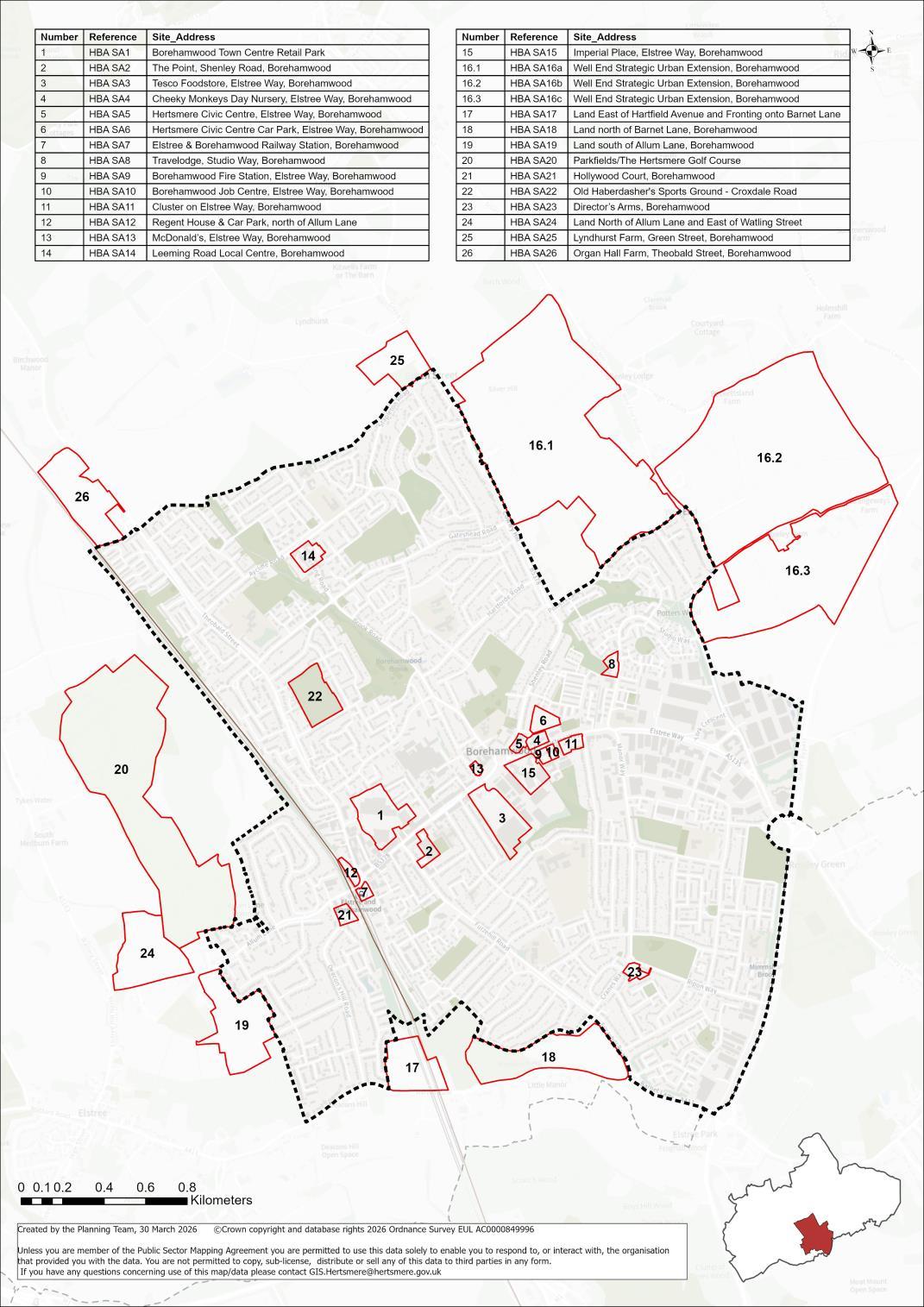
Borehamwood Area Sites
Hertsmere Borough Council
Hertsmere Local Plan Draft Regulation 18 Consultation Document
List of candidate sites:
HBA SA1 Borehamwood Town Centre Retail Park, Borehamwood
HBA SA2 The Point, Shenley Road, Borehamwood
HBA SA3 Tesco Foodstore, Elstree Way, Borehamwood
HBA SA4 Elstree Way Clinic, Cheeky Monkeys Nursery and former Library, Elstree Way
HBA SA5 Hertsmere Civic Offices, Elstree Way, Borehamwood
HBA SA6 Hertsmere Civic Offices Car Park, Elstree Way, Borehamwood
HBA SA7 Elstree & Borehamwood Railway Station, Borehamwood
HBA SA8 Travelodge, Studio Way, Borehamwood
HBA SA9 Borehamwood Fire Station, Elstree Way, Borehamwood
HBA SA10 Borehamwood Job Centre, Elstree Way, Borehamwood
HBA SA11 Cluster on Elstree Way (comprised of office building, Shell Garage and Kwik Fit), Borehamwood
HBA SA12 Regent House & Car Park, north of Allum Lane and west of Theobald Street, Borehamwood
HBA SA13 McDonalds, Elstree Way, Borehamwood
HBA SA14 Leeming Road Local Centre, Borehamwood
HBA SA15 Imperial Place, Elstree Way, Borehamwood
HBA SA16 Well End Strategic Urban Extension, Borehamwood
HBA SA17 Land East of Hartfield Avenue and Fronting onto Barnet Lane, Elstree
HBA SA18 Land north of Barnet Lane, Borehamwood
HBA SA19 Land South of Allum Lane, Elstree
HBA SA20 Parkfields/The Hertsmere Golf Course
HBA SA21 Hollywood Court, Borehamwood
HBA SA22 Old Haberdasher's Sports Ground, Croxdale Road, Borehamwood
HBA SA23 Directors Arms, Borehamwood
HBA SA24 Land North of Allum Lane and East of Watling Street, Elstree
Hertsmere Borough Council
Hertsmere Local Plan Draft Regulation 18 Consultation Document
HBA SA25 Lyndhurst Farm, Green Street, Borehamwood
HBA SA26 Organ Hall Farm, Theobald Street, Borehamwood
Hertsmere Local Plan Draft Regulation 18 Consultation Document
HBA SA1 Borehamwood Town Centre Retail Park, Borehamwood
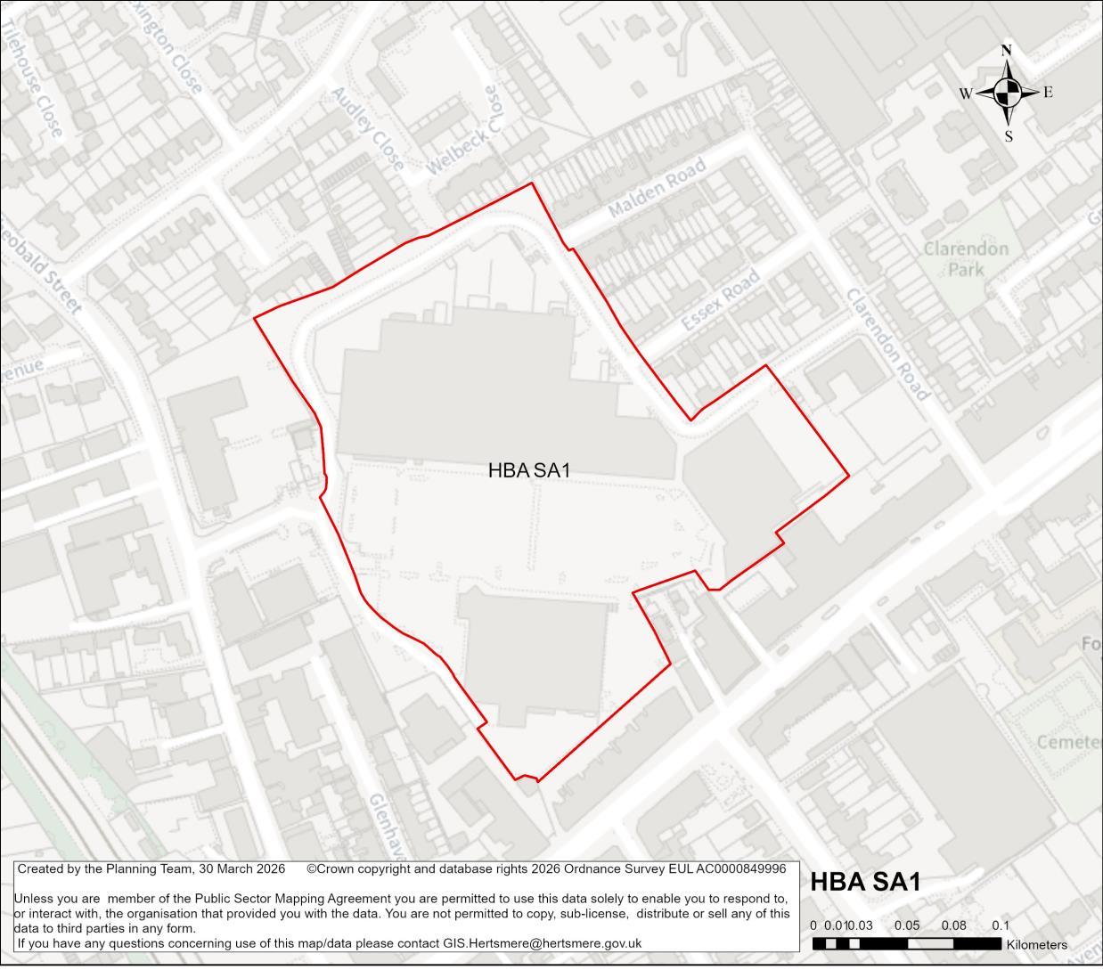
Site Address Borehamwood Town Centre Retail Park, Borehamwood
Site Details Town centre retail park located behind the main shopping street. Shares a boundary with two storey housing to the north and east, commercial and industrial units to the west, and main town centre uses to the south. Including about 20,000 sqm of main town centre uses; mostly retail but including The Grove Surgery and Anytime Fitness gym.
Hertsmere Borough Council
Hertsmere Local Plan Draft Regulation 18 Consultation Document
Planning Designations and Site Considerations
Strategic Urban Site. Comprehensive mixed-use redevelopment comprised of main-town centre uses (at ground and lower levels) and residential above. Public realm and open space.
Culverted watercourse (Main River) runs beneath the existing car park area. Reservoir flooding.
Planning Status No recent relevant planning history.
Timeframe for Delivery
Indicative Development Capacity
Years 1 – 5
Net Residential Units
501 dwellings
Years 6 –10 Years 11 –15 Beyond 15 Years
Gross Non-Residential Floorspace
To be confirmed – anticipated to include an appropriate level of re-provision of main town centre uses.
This central site is in the heart of Borehamwood’s town centre and is currently principally comprised of large retail units that make inefficient use of this sustainable location. In response a comprehensive mixed-use redevelopment is proposed, which will contribute towards wider town centre regeneration and make more efficient use of this sustainable location. This will comprise compatible main town centre, commercial, community and residential uses. The regeneration of the site will all secure new and improved transport infrastructure including road realignment and walking routes and cycleways. Public realm and environmental enhancements, including new public open space and planting The proposal will need consider any opportunity to resurface and naturalise the culverted watercourse (Borehamwood Brook), bearing in mind the constrained nature of the site and the need to prevent any potential flooding further downstream
The proposal will secure a higher quality townscape and built form that will ensure that Borehamwood Town Centre continues to meet the Borough’s main town centre use needs. The delivery of a comprehensive mixed-use development that includes higher intensity residential accommodation aligns with the spatial strategy proposed for the Borough This is a suitable location for tall buildings. The nature of this opportunity
Hertsmere Borough Council
Hertsmere Local Plan Draft Regulation 18 Consultation Document
suggests that it is likely to come forward for comprehensive redevelopment later in the plan period.
Developers will be required to prepare comprehensive proposals that deliver the mix and at least the quantum of development specified in the site allocation policy. As a strategic urban regeneration site, future proposals must be supported by masterplans, and design codes (if multiple phases are required) evidencing inclusive design. Landowners will be required to demonstrate that they are working positively in partnership to deliver development across the site.
Hertsmere Borough Council
Hertsmere Local Plan Draft Regulation 18 Consultation Document
HBA SA2 The Point, Shenley Road, Borehamwood
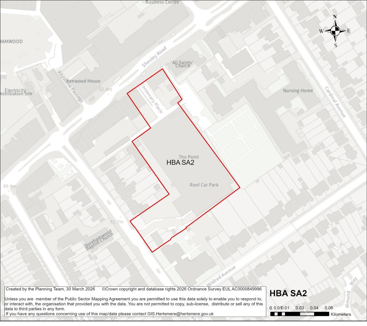
Site Address The Point, Shenley Road, Borehamwood
Site Details Town centre site consisting of a single-storey building containing leisure uses (cinema, gym and bingo hall), with rooftop public car parking.
Site Characteristics Site Size ha 1.02 ha Setting Central Urban Ownership Public (HBC) Current Use Town centre leisure uses (cinema and gym) and public surface car parking.
Planning Designations and Site Considerations
Strategic Urban Site. Comprehensive mixed-use redevelopment comprised of main-town centre uses (at ground and lower levels) and residential (with vertical intensification).
Hertsmere Borough Council
Hertsmere Local Plan Draft Regulation 18 Consultation Document
Consideration should be given to the reprovision of the existing public (local authority) car parking and leisure uses (cinema and gym), either onsite or elsewhere within Borehamwood Town Centre.
The site is within the setting of a Locally Listed church and adjoins its cemetery.
Planning Status No recent relevant planning history.
Timeframe for Delivery
Indicative
Years 1 – 5
Years 6 –10
Net Residential Units 51 dwellings
Gross Non-Residential Floorspace
Years 11 – 15
To be confirmed – the site has potential for compatible and complementary main town centre uses at the ground floor.
A comprehensive mixed-use redevelopment is proposed, which will contribute towards wider town centre regeneration and make more efficient use of this sustainable location. This will comprise compatible main town centre and residential uses, as well as reprovide the existing public parking. The existing leisure/community uses will ideally be relocated elsewhere as part of comprehensive redevelopment on the town centre, for example within the redeveloped Borehamwood Retail Park site (HBA SA1).
Redevelopment of the site will improve the relationship with the public realm and the nearby locally listed All Saints Church and cemetery and include appropriate levels of residential amenity space and parking.
The delivery of a comprehensive mixed-use development that includes higher intensity residential accommodation aligns with the spatial strategy proposed for the Borough. This is a suitable location for tall buildings, but development must consider the neighbouring two storey residential houses on Mildred Avenue.
Hertsmere Borough Council
Hertsmere Local Plan Draft Regulation 18 Consultation Document
Developers will be required to prepare comprehensive proposals that deliver the mix and at least the quantum of development specified in the site allocation policy. A site allocation will require that future proposals must be supported by masterplans evidencing inclusive design and demonstrate that landowners are working positively in partnership to deliver development across the site.
Hertsmere Borough Council
Hertsmere Local Plan Draft Regulation 18 Consultation Document
HBA SA3 Tesco Foodstore, Elstree Way, Borehamwood
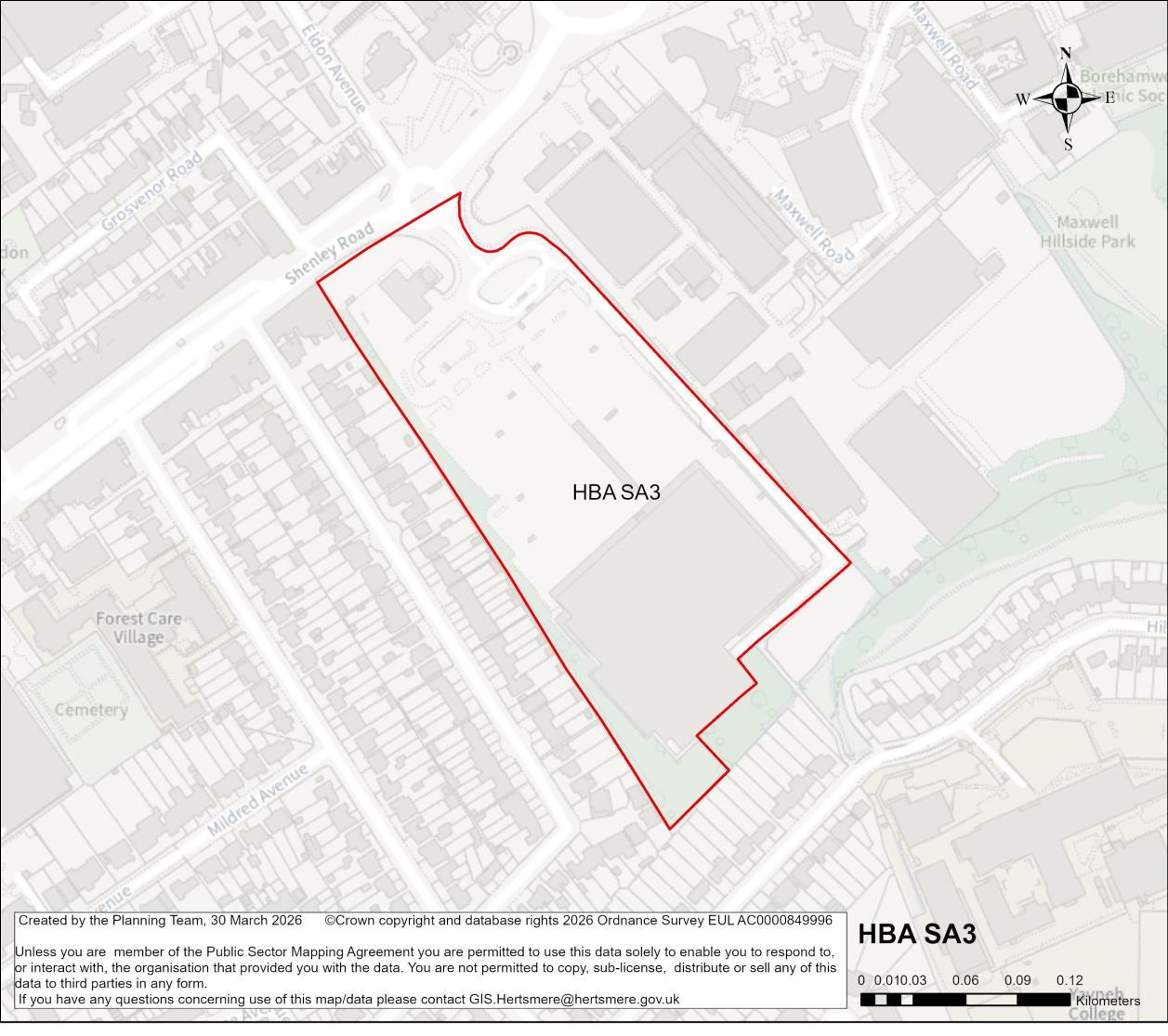
Site Address Tesco Foodstore, Elstree Way, Borehamwood
Site Details Town centre site containing a foodstore, surface-level car park and petrol filling station. The site abuts two storey housing, a public open space and commercial film studio site.
Site Characteristics Site Size ha 4.68 ha Setting Central Urban Ownership Private Current Use
Planning Designations and Site Considerations
Supermarket and surfacelevel car parking
Strategic Urban Site; comprehensive mixed-use redevelopment comprised of main-town centre uses (at ground and lower levels) and residential above (with vertical intensification).
Proximity to Yavneh College & Elstree studios as sensitive neighbours. Group Tree Preservation Order to the south-west corner of the site. Flood zone 2 and 3 near the site access. Surface water flood risk on the site.
Hertsmere Borough Council
Hertsmere Local Plan Draft Regulation 18 Consultation Document
Planning Status No recent relevant planning history.
Timeframe for Delivery Years 1 – 5 Years 6 –10 Years 11 – 15
Indicative Development Capacity
Beyond 15 Years
Net Residential Units
468 dwellings
Gross Non-Residential Floorspace
To be confirmed – comprehensive redevelopment could include the relocation and re-provision of the foodstore within the site (fronting Elstree Way).
A comprehensive mixed-use redevelopment is proposed, which will contribute towards wider town centre regeneration and make more efficient use of this sustainable location and ensure that Borehamwood Town Centre continues to meet the Borough’s main town centre use needs. This approach aligns with the spatial strategy proposed for the Borough
Development will comprise compatible main town centre and residential uses, including the potential reprovision of the supermarket and car parking in a format more suited to the town centre location. This is a suitable location for tall buildings that could exceed ten storeys.
The regeneration of the site will secure new and improved transport infrastructure including a public transport hub, potential road realignment, walking routes and cycleways. The site will be permeable to pedestrians and cyclists, and public realm and environmental enhancements will include new public open space, retention of the through-link to Hillside Avenue, Maxwell Park and Yavneh College, and planting that employs suitable local species to link through with Maxwell Park open space and enhance the ecological network within the town centre.
The development must consider sensitive uses on neighbouring sites including; potential overlooking to the commercially sensitive Elstree Studios backlot; the relationship with Maxwell Park public open space, the relationship with natural environments and biodiversity; and retaining the privacy and residential amenity of the existing 2-storey houses on Whitehouse Avenue and Hillside Avenue.
Hertsmere Borough Council
Hertsmere Local Plan Draft Regulation 18 Consultation Document
The introduction of any harmful town centre uses, such as hot food takeaways, betting shops, vape shops or amusement arcades, should be considered in the light of the proximity to the Hillside Avenue entrance to Yavneh College secondary school and sixth-form college.
Developers will be required to prepare comprehensive proposals that deliver the mix and at least the quantum of development specified in the site allocation policy. As a strategic urban regeneration site, future proposals must be supported by masterplans and design codes (if phasing is required) evidencing inclusive design. Proposals will also be required to demonstrate that landowners are working positively in partnership to deliver development across the site (in accordance with Policy DM3 Masterplans and Comprehensive Development).
Hertsmere Borough Council
Hertsmere Local Plan Draft Regulation 18 Consultation Document
HBA SA4 Former Library and Health Centre, Elstree Way, Borehamwood
Elstree Way Clinic, Cheeky Monkeys Nursery and former Library, Elstree Way
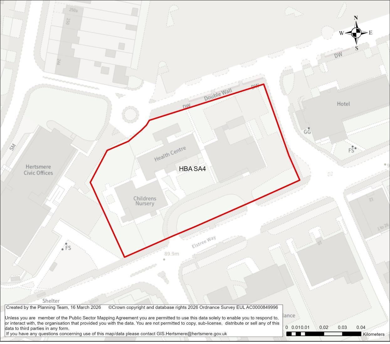
Site Address Elstree Way Clinic, Cheeky Monkeys Nursery and former Library, Elstree Way
Site Details The site consists of several single-storey buildings, in varying use including a children’s nursery, an NHS clinic and a community shop. Site
Borough Council
Hertsmere Local Plan Draft Regulation 18 Consultation Document
Planning Designations and Site Considerations
Urban Site: Comprehensive mixed-use redevelopment comprised of social/ community infrastructure (at ground level) and residential above (with vertical intensification).
Scope for comprehensive redevelopment of the area comprising sites HBA SA4, HBA SA5 and HBA SA6.
Surface water flood risk and Flood Zones 2 and 3 on the site.
Planning Status No recent relevant planning history. Timeframe
Gross Non-Residential Floorspace
To be confirmed – the site has potential for compatible and complementarysocial infrastructure uses at the ground floor.
The delivery of a comprehensive mixed-use development that includes higher intensity residential accommodation will secure a higher quality townscape and built form which aligns with the spatial strategy proposed for the Borough. This is a suitable location for tall buildings. Redevelopment would potentially include re-provision of the existing social and community infrastructure (NHS clinic, day nursery and community pantry) at ground/lower levels if necessary, and high-density residential above. The designled approach and masterplanning process will require that future development integrates with the evolving townscape across Elstree Way.
To secure comprehensive regeneration the site should be brought forward in conjunction with the neighbouring sites (HBA SA5 and HBA SA6) to provide a highquality comprehensive redevelopment of the area, in particular the public realm, and to enable high quality re-provision of existing uses where needed.
Hertsmere Borough Council
Hertsmere Local Plan Draft Regulation 18 Consultation Document
Developers will be required to prepare comprehensive proposals that deliver the mix and at least the quantum of development specified in the site allocation policy. As an urban regeneration site, future proposals must be supported by masterplans, and design codes (if multiple phases are required) evidencing inclusive design. Landowners will be required to demonstrate that they are working positively in partnership to deliver development across the site.
Hertsmere Borough Council
Hertsmere Local Plan Draft Regulation 18 Consultation Document
HBA SA5 Hertsmere Civic Offices, Elstree Way, Borehamwood
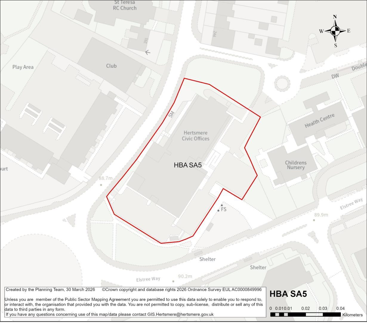
Site Address Hertsmere Civic Offices, Elstree Way, Borehamwood
Site Details Local authority offices, police station and NHS clinic. The site occupies a key location on the Shenley Road/Elstree Way/Brook Road roundabout and adjoins the Elstree Way Clinic site (HBA SA4).
Site Characteristics
Planning Designations and Site
Considerations
Site Size ha
0.48 ha Setting Central Urban Ownership HBC Current Use Council offices, police station, NHS clinic
Urban Site: Comprehensive mixed-use redevelopment comprised of social/ community infrastructure (at ground level) and residential above (with vertical intensification).
Scope for comprehensive redevelopment of the area comprising sites HBA SA4, HBA SA5 and HBA SA6.
Surface water flood risk and Flood Zones 2 and 3 on the site.
Planning Status No recent relevant planning history.
Hertsmere Borough Council
Hertsmere Local Plan Draft Regulation 18 Consultation Document
Timeframe for Delivery
Indicative Development Capacity
Years 1 – 5 Years 6 –10 Years 11 – 15
Net Residential Units
95 dwellings
Gross Non-Residential Floorspace
Beyond 15 Years
To be confirmed – the site has potential for compatible and complementary main town centre/ social infrastructure uses at the ground floor.
The delivery of a comprehensive mixed-use development that includes higher intensity residential accommodation will secure a high-quality townscape and built form which aligns with the spatial strategy proposed for the Borough. This is a suitable location for tall buildings so vertical intensification will be expected to make efficient use of the site The design-led approach and masterplanning process will require that future development integrates with the evolving townscape across Elstree Way.
The development should enhance the overall townscape, making the most of this key gateway to the town centre. Walking and cycling improvements will be sought to the Elstree Way/Shenley Road/Brook Road roundabout, which is a key link with the town centre and station This site should be brought forward in conjunction with the neighbouring sites (sites HBA SA4 and HBA SA6) to provide a high-quality comprehensive redevelopment of the area, in particular the public realm, and to enable high quality re-provision of existing uses where needed.
Developers will be required to prepare comprehensive proposals that deliver the mix and at least the quantum of development specified in the site allocation policy. As an urban regeneration site, future proposals must be supported by masterplans, and design codes (if multiple phases are required) evidencing inclusive design. Landowners will be required to demonstrate that they are working positively in partnership to deliver development across the site.
Hertsmere Borough Council
Hertsmere Local Plan Draft Regulation 18 Consultation Document
HBA SA6 Hertsmere Civic Offices Car Park, Elstree Way, Borehamwood
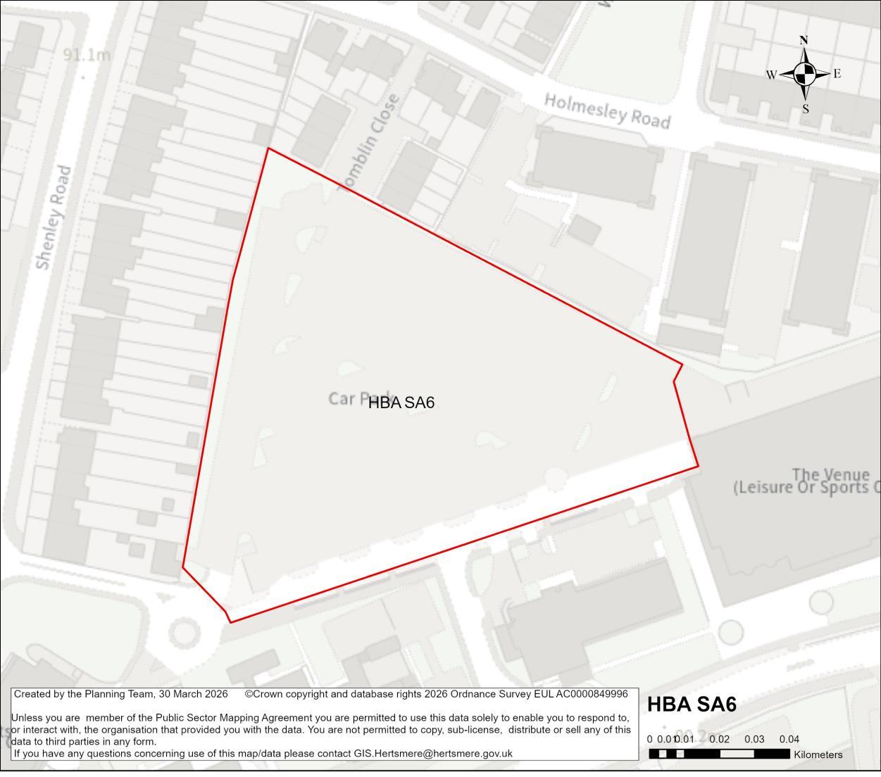
Site Address Hertsmere Civic Offices Car Park, Elstree Way, Borehamwood
Site Details The site comprises of a large car park area, with minimal landscaping features. Boundaries are shared with residential properties to the north and west of the site.
Site Characteristics Site Size ha 1.15 ha Setting Central Urban Ownership HBC Current Use Public car park
Planning Designations and Site Considerations
Urban Site; Comprehensive redevelopment comprised of residential, open space and public realm (with vertical intensification).
Scope for comprehensive redevelopment of the area comprising sites HBA SA4, HBA SA5 and HBA SA6.
Small area of Flood Zone 2 on the western edge of the site.
Planning Status No recent relevant planning history.
Timeframe for Delivery Years 1 – 5 Years 6 –10 Years 11 – 15 Beyond 15 Years
Hertsmere Borough Council
Hertsmere Local Plan Draft Regulation 18 Consultation Document
Indicative Development Capacity
Net Residential Units
115 dwellings
Gross Non-Residential Floorspace
To be confirmed – the site has potential for compatible and complementary main town centre/ social infrastructure uses at the ground floor.
A comprehensive redevelopment is proposed, which will contribute towards wider regeneration along Elstree Way and make more efficient use of this sustainable location, and will primarily comprise of residential uses. The regeneration of the site will secure walking and cycling routes, as well as public realm and environmental enhancements.
The proposal will secure high quality townscape and built form that will ensure that this area contributes positively to the Borehamwood town centre, and meeting the area’s needs. The delivery of a higher intensity residential accommodation aligns with the spatial strategy proposed for the Borough. This is a suitable location for tall buildings. The design-led approach and masterplanning process will require that future development integrates with the evolving townscape across Elstree Way.
This site should be brought forward in conjunction with the neighbouring sites (HBA SA4 and HBA SA5) to provide a high-quality comprehensive redevelopment of the area, in particular the public realm, and to enable high quality re-provision of existing uses where needed.
Developers will be required to prepare comprehensive proposals that deliver the mix and at least the quantum of development specified in the site allocation policy. As an urban regeneration site, future proposals must be supported by masterplans, and design codes (if multiple phases are required) evidencing inclusive design. Landowners will be required to demonstrate that they are working positively in partnership to deliver development across the site.
Hertsmere Borough Council
Hertsmere Local Plan Draft Regulation 18 Consultation Document
HBA SA7 Elstree & Borehamwood Railway Station, Borehamwood
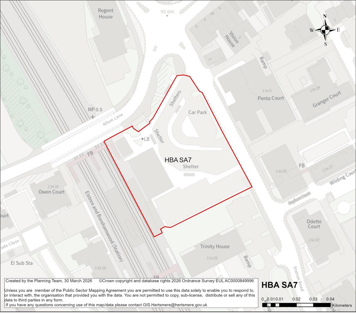
Site Address Elstree & Borehamwood Railway Station, Borehamwood
Site Details The site includes a Railway Station, bus stops, and car park.
Site Characteristics Site Size ha 0.43 ha Setting Central Urban Ownership Public (Network Rail, leased to train operator)
Planning Designations and Site Considerations
Current Use
Railway station and forecourt area
Urban Site; Comprehensive mixed-use redevelopment comprised of sustainable travel network infrastructure (at ground level) and residential above (with vertical intensification).
Small area of surface water flood risk and Flood Zone 2 near the site access. Development has the potential to impact the setting of Grade II listed building Manor House.
Planning Status No recent relevant planning history.
Hertsmere Borough Council
Hertsmere Local Plan Draft Regulation 18 Consultation Document
Timeframe for Delivery Years 1 – 5 Years 6 –10 Years 11 – 15
Indicative Development Capacity
Beyond 15 Years
Net Residential Units
43 dwellings
Gross Non-Residential Floorspace
To be confirmed – the site could include a complementary main town centre uses at the ground floor (as part of new public transport hub).
A comprehensive redevelopment is proposed, which will contribute towards wider town centre regeneration and make more efficient use of this sustainable location, and will primarily comprise of residential uses. The regeneration of the site will secure an enhanced station concourse and improved public realm at ground level, alongside travel infrastructure (bus station, taxi rank, cycle parking and passenger drop-off/pickup) and disabled parking.
The proposal will secure high quality townscape and built form that will ensure that this area contributes positively to the Borehamwood townscape in this strategic location. The delivery of a higher intensity residential accommodation aligns with the spatial strategy proposed for the Borough. This is a suitable location for tall buildings.
Developers will be required to prepare comprehensive proposals that deliver the mix and at least the quantum of development specified in the site allocation policy. As an urban regeneration site, future proposals must be supported by masterplans, and design codes (if multiple phases are required) evidencing inclusive design. Landowners will be required to demonstrate that they are working positively in partnership to deliver development across the site.
Hertsmere Borough Council
Hertsmere Local Plan Draft Regulation 18 Consultation Document
HBA SA8 Travelodge, Studio Way, Borehamwood
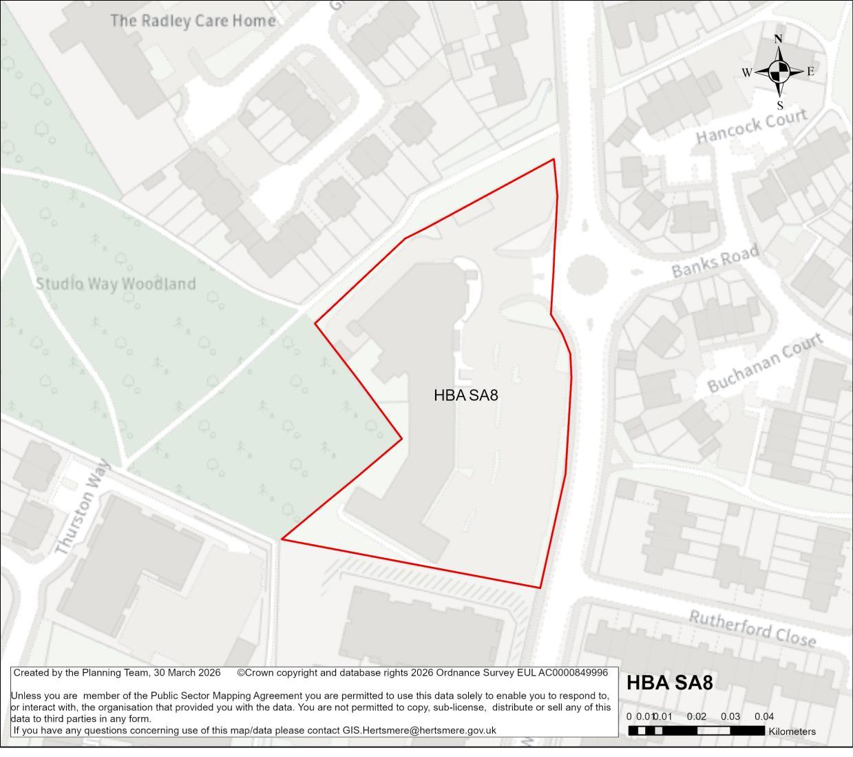
Site Address Travelodge, Studio Way, Borehamwood
Site Details The site currently comprises of the Travelodge and attached Toby Carvery. The site is in proximity to residential properties.
Site Characteristics
Planning Designations and Site Considerations
Urban Site; Comprehensive redevelopment comprised of residential, open space and public realm (with vertical intensification).
The site is in proximity to a large Tree Preservation Order. No other constraints identified on the site.
Planning Status No recent relevant planning history.
Hertsmere Borough Council
Hertsmere Local Plan Draft Regulation 18 Consultation Document
Timeframe for Delivery Years 1 – 5 Years 6 –10 Years 11 – 15
Indicative Development Capacity
Beyond 15 Years
Net Residential Units
33 dwellings
Gross Non-Residential Floorspace
To be confirmed – the site could deliver modest convenience retail provision at ground floor level.
A comprehensive redevelopment is proposed, which will contribute towards wider urban regeneration across Borehamwood and make more efficient use of this sustainable location, and will primarily comprise of residential uses. The regeneration of the site will secure walking and cycling routes, as well as public realm and open space provision. The development will preserve and enhance the ecological value of the adjoining Studio Way Woodland, through improvements to ecological networks and Biodiversity Net Gain
Redevelopment needs to address the juncture between the higher-density central urban area on Elstree Way and lower density 2-storey residential development of Studio Way Estate.
The proposal will secure high quality townscape and built form that will ensure that this area contributes positively to Borehamwood’s townscape, and meeting the area’s needs. The delivery of a higher intensity residential accommodation aligns with the spatial strategy proposed for the Borough.
Developers will be required to prepare comprehensive proposals that deliver the mix and at least the quantum of development specified in the site allocation policy. As an urban site, future proposals must be supported by masterplans, and design codes (if multiple phases are required) evidencing inclusive design. Landowners will be required to demonstrate that they are working positively in partnership to deliver development across the site.
Hertsmere Borough Council
Hertsmere Local Plan Draft Regulation 18 Consultation Document
HBA SA9 Borehamwood Fire Station, Elstree Way, Borehamwood
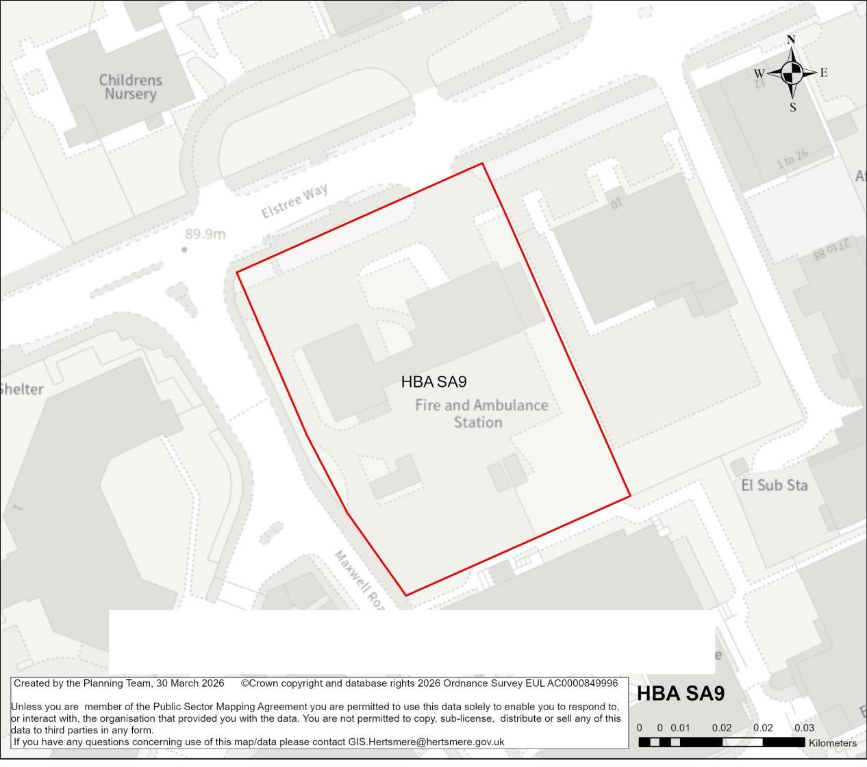
Site Address Borehamwood Fire Station, Elstree Way, Borehamwood
Site Details The site currently comprises of the fire station on Elstree Way, which is a single storey building. It is located immediately adjacent to SA10.
Site Characteristics Site Size ha 0.36ha Setting Central Urban Ownership Public Current Use Fire Station
Planning Designations and Site Considerations
Urban Site; Comprehensive mixed-use redevelopment comprised of social/ community infrastructure (at ground level) and residential above (with vertical intensification).
Where possible this site should be brought forward alongside site HBA SA10.
Relocation of the Fire Station would be required to suit service requirements. Area of Flood Zone 2 near the site access.
Planning Status No recent relevant planning history.
Hertsmere Borough Council
Hertsmere Local Plan Draft Regulation 18 Consultation Document
Timeframe for Delivery Years 1 – 5 Years 6 –10 Years 11 – 15
Indicative Development Capacity
Beyond 15 Years
Net Residential Units
36 dwellings
Gross Non-Residential Floorspace
To be confirmed – the site has potential for compatible and complementary main town centre/ social infrastructure uses at the ground floor.
A comprehensive redevelopment is proposed, which will contribute towards wider regeneration along Elstree Way and make more efficient use of this sustainable location, and will primarily comprise of residential uses. The regeneration of the site will secure walking and cycling routes, as well as public realm and environmental enhancements.
The redevelopment of the candidate site provides an opportunity to secure high-quality townscape and built form that will ensure that this area contributes positively to Borehamwood’s townscape, and meeting the area’s needs. The delivery of a higher intensity residential accommodation aligns with the spatial strategy proposed for the Borough. This is a suitable location for tall buildings. The design-led approach and masterplanning process will require that future development integrates with the evolving townscape across Elstree Way.
Social and community infrastructure should be incorporated within the development if required, at ground floor level in consultation between the Council and local groups, considering the nearby Maxwell Park Community Centre. It may be an option for development on this site to provide enhancements to Maxwell Park Community Centre in place of community provision on-site, depending on how best to meet community needs and to make efficient use of the land. The site should address the public realm along Elstree Way, but also on Maxwell Road, enhancing the public access to Maxwell Park public open space.
Developers will be required to prepare comprehensive proposals that deliver the mix and at least the quantum of development specified in the site allocation policy. As an urban regeneration site, future proposals must be supported by masterplans, and
Hertsmere Borough Council
Hertsmere Local Plan Draft Regulation 18 Consultation Document
design codes (if multiple phases are required) evidencing inclusive design. Landowners will be required to demonstrate that they are working positively in partnership to deliver development across the site.
The redevelopment of the site is dependent upon the existing use being relocated to an appropriate new home. It is understood that blue light services no longer to have a requirement to secure public facing accommodation, and alternatives can include relocation to highly accessible industrial employment sites. The Council will work with blue light service providers to identify appropriate accessible provision.
Hertsmere Borough Council
Hertsmere Local Plan Draft Regulation 18 Consultation Document
HBA SA10 Borehamwood Job Centre, Elstree Way, Borehamwood
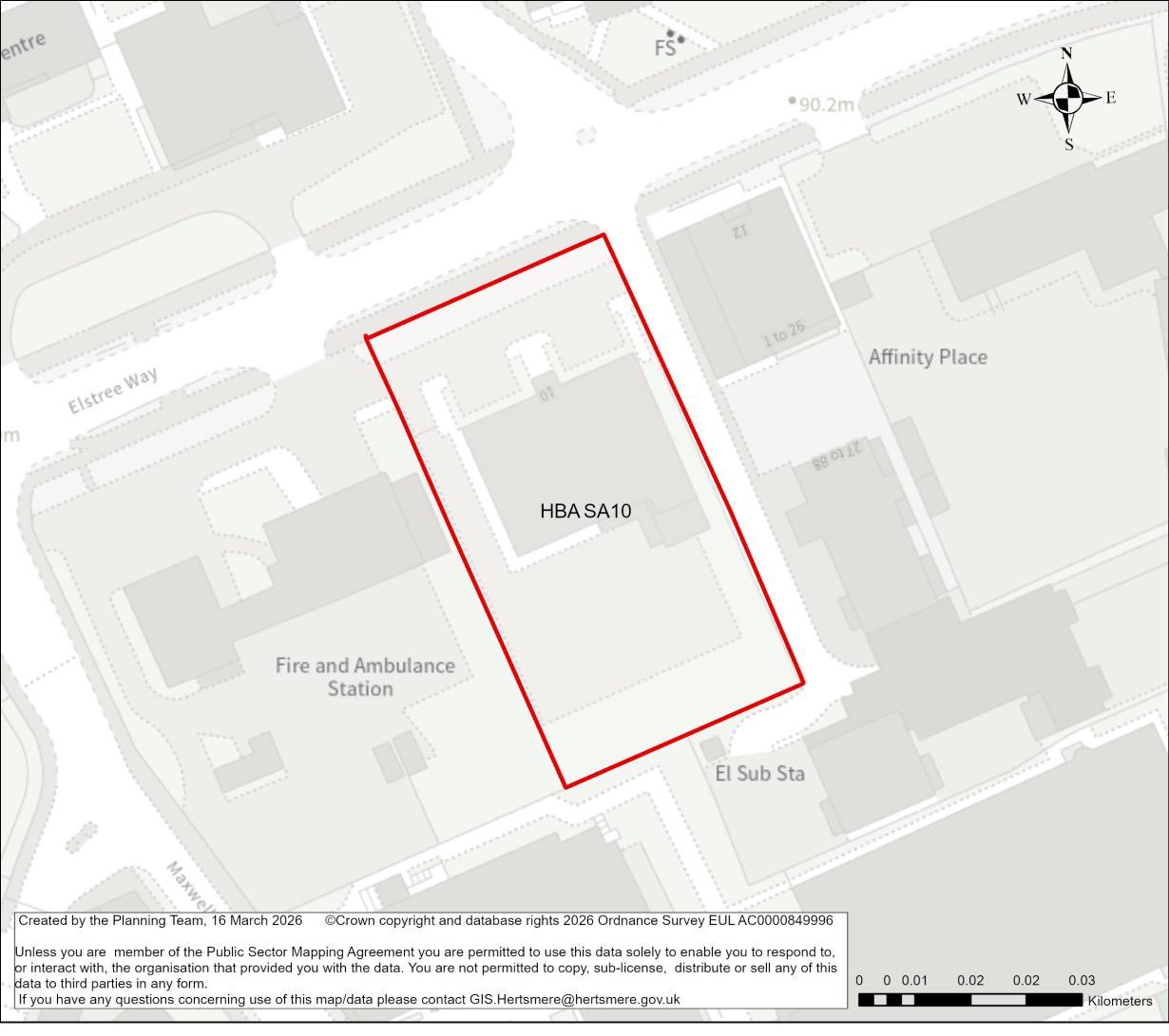
Site Address Borehamwood Job Centre, Elstree Way, Borehamwood
Site Details The site currently comprises of the job centre on Elstree Way, which is a single storey building. It is located immediately adjacent to SA9.
Site Characteristics Site Size ha 0.27 ha Setting Central Urban Ownership Public Current Use Job Centre
Planning Designations and Site Considerations
Urban Site; Comprehensive mixed-use redevelopment comprised of social/ community infrastructure (at ground level) and residential above (with vertical intensification).
Where possible this site should be brought forward alongside Site HBA SA9
Area of Flood Zone 2 near the site access.
Planning Status No recent relevant planning history.
Timeframe for Delivery Years 1 – 5 Years 6 –10 Years 11 – 15 Beyond 15 Years
Hertsmere Borough Council
Hertsmere Local Plan Draft Regulation 18 Consultation Document
Gross Non-Residential Floorspace
To be confirmed – the site has potential for compatible and complementary main town centre/ social infrastructure uses at the ground floor.
A comprehensive redevelopment is proposed, which will contribute t towards wider regeneration along Elstree Way and make more efficient use of this sustainable location, and will primarily comprise of residential uses. The regeneration of the site will secure walking and cycling routes, as well as public realm and environmental enhancements.
The redevelopment of the candidate site provides an opportunity to secure high quality townscape and built form that will ensure that this area contributes positively to Borehamwood’s townscape, and meeting the area’s needs. The delivery of a higher intensity residential accommodation aligns with the spatial strategy proposed for the Borough. This is a suitable location for tall buildings. The design-led approach and masterplanning process will require that future development integrates with the evolving townscape across Elstree Way.
Social and community infrastructure should be incorporated within the development if required, at ground floor level in consultation between the Council and local groups, considering the nearby Maxwell Park Community Centre. It may be an option for development on this site to provide enhancements to Maxwell Park Community Centre in place of community provision on-site, depending on how best to meet community needs and to make efficient use of the land. The site should address the public realm along Elstree Way, but also on Maxwell Road, enhancing the public access to Maxwell Park public open space.
Developers will be required to prepare comprehensive proposals that deliver the mix and at least the quantum of development specified in the site allocation policy. As an urban regeneration site, future proposals must be supported by masterplans, and design codes (if multiple phases are required) evidencing inclusive design.
Hertsmere Borough Council
Hertsmere Local Plan Draft Regulation 18 Consultation Document
Landowners will be required to demonstrate that they are working positively in partnership to deliver development across the site.
Hertsmere Borough Council
Hertsmere Local Plan Draft Regulation 18 Consultation Document
HBA SA11 Cluster on Elstree Way (comprised of office building, Shell Garage and Kwik Fit), Borehamwood
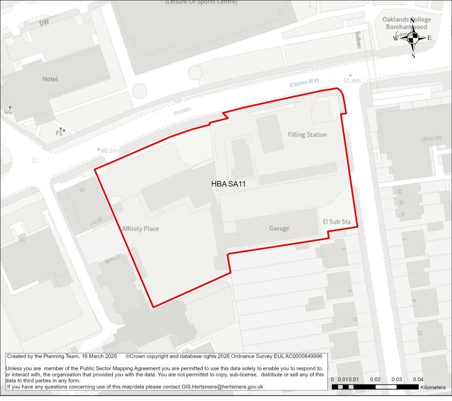
Site Address Cluster on Elstree Way (comprised of office building, Shell Garage and Kwik Fit), Borehamwood
Site Details The site comprises of the former police station, the Shell petrol station, and the Kwik Fit garage. These are primarily single storey buildings. The former police station comprises of a taller building in poor condition.
Site Characteristics Site Size ha 0.74 ha Setting Central Urban Ownership Private Current Use Various uses including car repair garage, petrol filling station and offices.
Planning Designations and Site Considerations
Planning Status
Urban Site; Comprehensive mixed-use redevelopment comprised of main town centre / employment uses (at ground level) and residential above (with vertical intensification).
Areas of Flood Zone 2, and surface water flood risk.
20/0057/OUT: Demolition of the former police station and construction of 1 seven storey and 1 eight storey building containing 96 flats, with associated bin and bike storage, car parking. (Outline Application to include access, appearance, layout & scale, with landscaping matters reserved.)
25/1394/FUL: Demolition of existing sales building and erection of a new sales building with associated works. [Shell petrol stations]
Hertsmere Local Plan Draft Regulation 18 Consultation Document
Timeframe for Delivery Years 1 – 5 Years 6 –10 Years 11 – 15
Indicative Development Capacity
Beyond 15 Years
Net Residential Units
74 dwellings
Gross Non-Residential Floorspace
To be confirmed – comprehensive redevelopment of the site could include a mix of complementary main town centre and employment uses (as defined under Class E), could be delivered at ground floor level.
A comprehensive redevelopment is proposed, which will contribute towards wider regeneration along Elstree Way and make more efficient use of this sustainable location, and will primarily comprise of residential uses, with employment uses at ground floor. The regeneration of the site will secure walking and cycling routes, as well as public realm and environmental enhancements.
The redevelopment of the candidate site provides an opportunity to secure high-quality townscape and built form that will ensure that this area contributes positively to Borehamwood’s townscape, and meeting the area’s needs. The delivery of a higher intensity residential accommodation aligns with the spatial strategy proposed for the Borough. This is a suitable location for tall buildings. The design-led approach and masterplanning process will require that future development integrates with the evolving townscape across Elstree Way.
Developers will be required to prepare comprehensive proposals that deliver the mix and at least the quantum of development specified in the site allocation policy. As an urban regeneration site, future proposals must be supported by masterplans, and design codes (if multiple phases are required) evidencing inclusive design. Landowners will be required to demonstrate that they are working positively in partnership to deliver development across the site.
The candidate site has a live consent. It forms part of the Borough’s committed fiveyear housing land supply. The principle of it providing a source of supply that delivers growth is established. On that basis it will become a site allocation.
Hertsmere Borough Council
Hertsmere Local Plan Draft Regulation 18 Consultation Document
As a live consent that contributes towards the Borough’sfive-year housing land supply, the Council considers it reasonable to assume that the site will commence and begin to deliver growth and meet needs in a timely manner38. Consents that fail to deliver and consequently require renewal will in the future be assessed against the new Local Plan. Should that arise, the Council may consider measures that secure greater certainty of timely delivery.
38 To make a meaningful contribution to Housing Delivery performance consented housing schemes must deliver within three years of receiving consent.
Hertsmere Borough Council
Hertsmere Local Plan Draft Regulation 18 Consultation Document
HBA SA12 Regent House & Car Park, north of Allum Lane and west of Theobald Street, Borehamwood
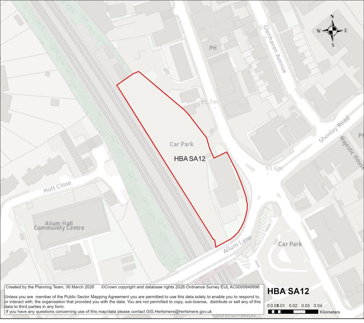
Site Address Regent House & Car Park, north of Allum Lane and west of Theobald Street, Borehamwood
Site Details The site comprises of Regent House, a three-storey office building on the corner of Allum Lane and Theobald Street, and the car park to the rear.
Site Characteristics
Planning Designations and Site Considerations
Site Size ha
0.55 ha Setting Urban Ownership
Private (office buildings) and Public (car park)
Current Use
Office buildings, and car park to the rear serving railway station
Urban Site; Comprehensive redevelopment comprised of residential and public realm (with vertical intensification).
Potential development impact on the setting of Grade II listed building Manor House.
Hertsmere Borough Council
Hertsmere Local Plan Draft Regulation 18 Consultation Document
Planning Status No recent relevant planning history.
Timeframe for Delivery Years 1 – 5 Years 6 –10 Years 11 – 15 Beyond 15 Years
Indicative Development Capacity
Net Residential Units
55 dwellings
Gross Non-Residential Floorspace
To be confirmed – comprehensive redevelopment of the site could include a mix of complementary main town centre and employment uses (as defined under Class E), to be delivered at ground floor level.
A comprehensive redevelopment is proposed, which will contribute towards wider town centre regeneration and make more efficient use of this sustainable location, and will primarily comprise of residential uses. The regeneration of the site will secure walking and cycling routes, as well as public realm and environmental enhancements.
The redevelopment of the candidate site provides an opportunity to secure high-quality townscape and built form that will ensure that this area contributes positively to Borehamwood’s townscape at this prominent location, and meeting the area’s needs. The delivery of a higher intensity residential accommodation aligns with the spatial strategy proposed for the Borough. This is a suitable location for tall buildings. The design-led approach and masterplanning process will require that future development integrates with the town centre’s wider townscape.
Developers will be required to prepare comprehensive proposals that deliver the mix and at least the quantum of development specified in the site allocation policy. As an urban regeneration site, future proposals must be supported by masterplans, and design codes (if multiple phases are required) evidencing inclusive design. Landowners will be required to demonstrate that they are working positively in partnership to deliver development across the site.
Hertsmere Borough Council
Hertsmere Local Plan Draft Regulation 18 Consultation Document
HBA SA13 McDonalds, Elstree Way, Borehamwood
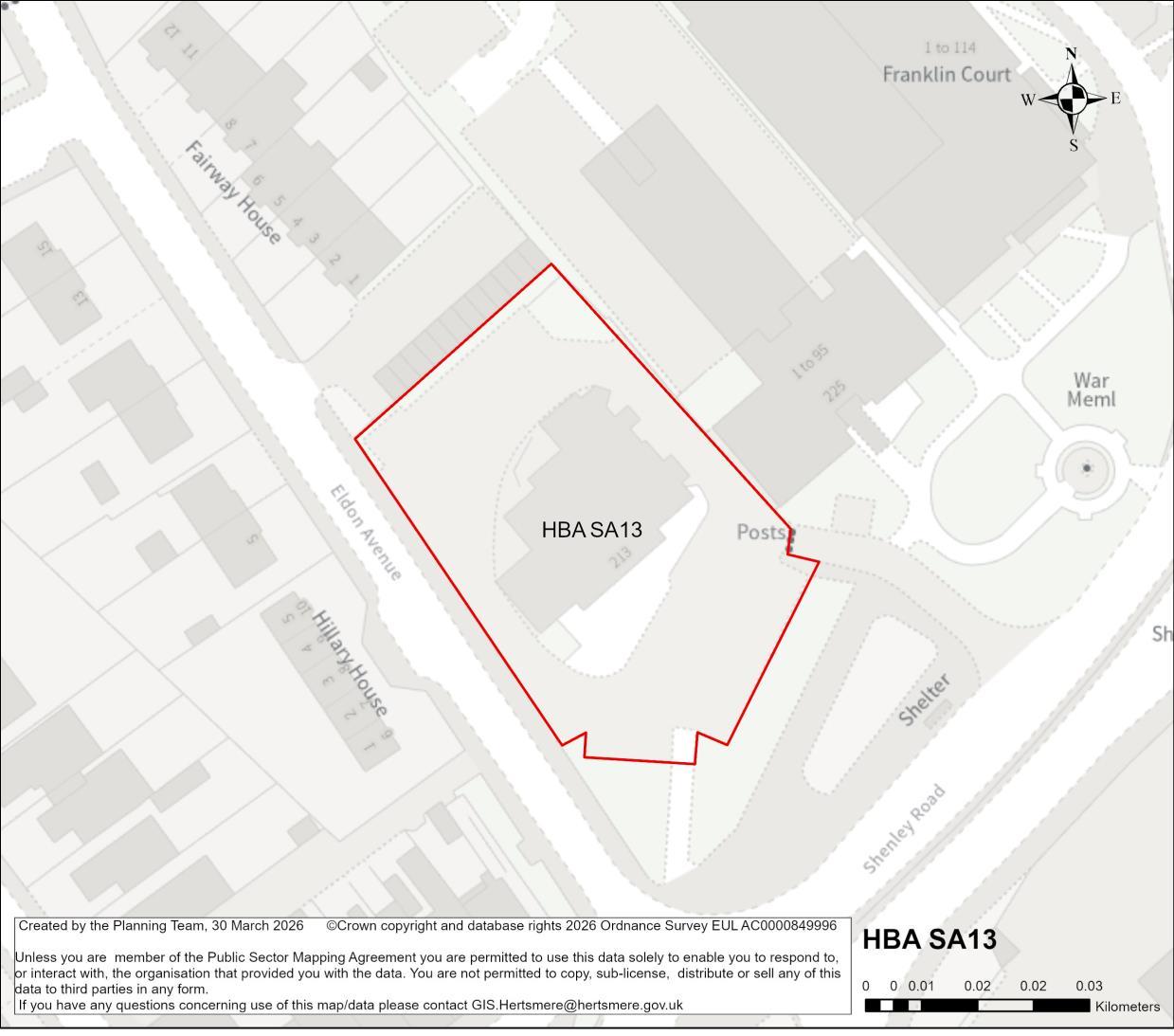
Site Address McDonalds, Elstree Way, Borehamwood
Site Details The site contains a fast-food outlet, with associated parking and drive-thru facilities.
Site Characteristics
Planning Designations and Site
Considerations
Site Size ha 0.26 ha Setting Central Urban Ownership Private Current Use Fast food restaurant and associated parking/drive-thru
Urban Site; Comprehensive mixed-use redevelopment comprised of main town centre/ employment uses (at ground level) and residential above (with vertical intensification).
The building on site is a locally listed building, and presumption against demolition of locally listed buildings applies. Flood Zone 2 and 3, as well as surface water flood risk near the site access. Potential intensification of remaining site.
Hertsmere Borough Council
Hertsmere Local Plan Draft Regulation 18 Consultation Document
Planning Status No recent relevant planning history.
Timeframe for Delivery Years 1 – 5 Years 6 –10 Years 11 – 15 Beyond 15 Years
Indicative Development
Capacity
Net Residential Units
26 dwellings
There is potential for the re-provision of appropriate new main town centre uses, as defined under Class E, across the ground floor.
A comprehensive redevelopment is proposed, which will contribute towards wider town centre regeneration and make more efficient use of this sustainable location, and will primarily comprise of residential uses. The regeneration of the site will secure walking and cycling routes, as well as public realm and environmental enhancements.
The redevelopment of the candidate site provides an opportunity to secure high-quality townscape and built form that will ensure that this area contributes positively to Borehamwood’s townscape at this prominent location, and meeting the area’s needs. The delivery of a higher intensity residential accommodation aligns with the spatial strategy proposed for the Borough. This is a suitable location for tall buildings. The design-led approach and masterplanning process will require that future development integrates with the town centre’s wider townscape.
Whilst the site includes a locally listed building, the opportunities for urban regeneration and intensification present across other neighbouring sites suggest that it merits consideration through the plan-making process under Regulation 18.
Hertsmere Borough Council
Hertsmere Local Plan Draft Regulation 18 Consultation Document
Developers will be required to prepare comprehensive proposals that deliver the mix and at least the quantum of development specified in the site allocation policy. As an urban regeneration site, future proposals must be supported by masterplans, evidencing inclusive design. Landowners will be required to demonstrate that they are working positively in partnership to deliver development across the site.
Hertsmere Borough Council
Hertsmere Local Plan Draft Regulation 18 Consultation Document
HBA SA14 Leeming Road Local Centre, Borehamwood
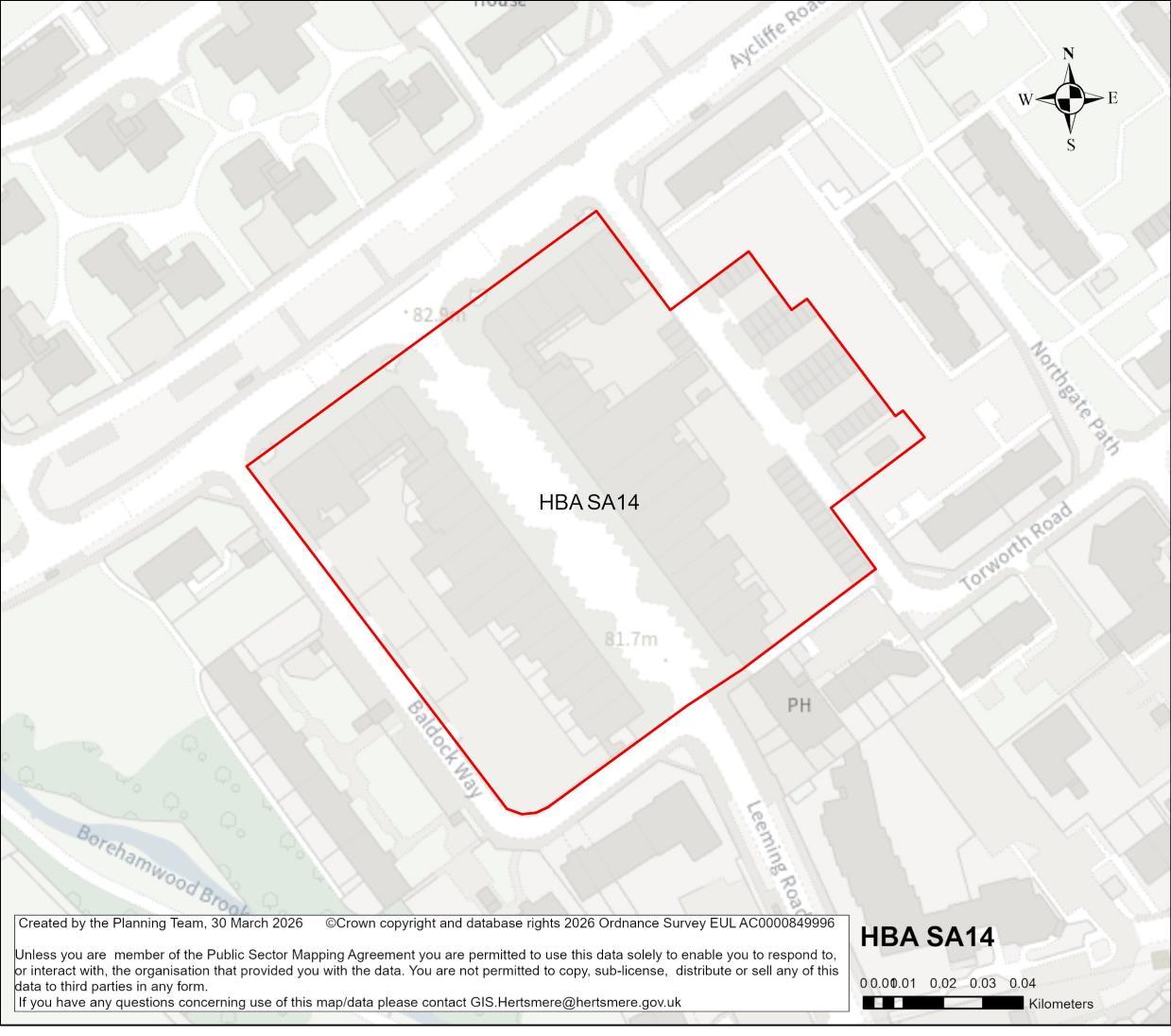
Site Address Leeming Road Local Centre, Borehamwood
Site Details The area comprises of ground floor retail units with some flatted accommodation above.
Site Characteristics Site Size ha 1.42 ha Setting Urban Ownership Public – HBC Current Use Mixed use –shopping parade with residential above
Planning Designations and Site
Considerations
Urban Site; Comprehensive mixed-use redevelopment comprised of main town centre/ employment uses (at ground level), public realm and residential above (with vertical intensification).
Reprovision of designated local shopping centre. The site is adjacent to a public right of way. Some surface water flood risk near the site.
Hertsmere Borough Council
Hertsmere Local Plan Draft Regulation 18 Consultation Document
Planning Status No recent relevant planning history.
Timeframe for Delivery Years 1 – 5 Years 6 –10 Years 11 – 15
Indicative Development Capacity
Beyond 15 Years
Net Residential Units
71 dwellings (net)
Gross Non-Residential Floorspace
It is anticipated that the existing main town centre uses will be re-provided on a like-for-like basis across the redeveloped site.
A comprehensive redevelopment is proposed, which will contribute towards wider town centre regeneration and make more efficient use of this sustainable location, and will primarily comprise of residential uses, and provision of retail units at ground floor.
The regeneration of the site will secure walking and cycling routes, as well as public realm and environmental enhancements.
The regeneration of the site could secure high-quality townscape and built form that will ensure that this area contributes positively to Borehamwood’s townscape at this prominent location, and meeting the area’s needs. The delivery of a higher intensity residential accommodation aligns with the spatial strategy proposed for the Borough. The site may be capable of accommodating higher density development in the form of mid-rise buildings. Proposals for tall new buildings will be required to demonstrate that the surrounding townscape has sufficient capacity for them to be accommodated.
Developers will be required to prepare comprehensive proposals that deliver the mix and at least the quantum of development specified in the site allocation policy. The re-provision of the existing main town centre uses provide an opportunity to improve the quality available across the site. This will benefit both existing and future communities.
Hertsmere Borough Council
Hertsmere Local Plan Draft Regulation 18 Consultation Document
As an urban regeneration site, future proposals must be supported by masterplans, and design codes (if multiple phases are required) evidencing inclusive design. Landowners will be required to demonstrate that they are working positively in partnership to deliver development across the site.
Hertsmere Borough Council
Hertsmere Local Plan Draft Regulation 18 Consultation Document
HBA SA15 Imperial Place, Elstree Way, Borehamwood
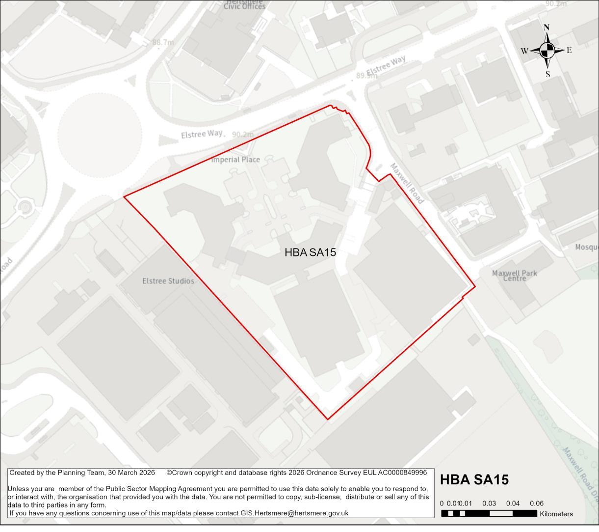
Site Address Imperial Place, Elstree Way, Borehamwood
Site Details The site comprises of office buildings and associated multi-storey car park.
Site Characteristics Site Size ha 2.3 ha Setting Central Urban Ownership Private Current Use Offices
Planning Designations and Site Considerations
Urban Site; Comprehensive mixed-use redevelopment comprised of main town centre/ employment uses (at ground level), public realm and residential above (with vertical intensification).
Site is adjacent to existing public right of way. Culverted water course on the eastern boundary of the site. Existing multi-storey car park is in Flood Zones 2 and 3, while much of the site is covered by surface water flood risk.
Planning Status No relevant recent planning history.
Timeframe for Delivery Years 1 – 5 Years 6 –10 Years 11 – 15 Beyond 15 Years
Gross Non-Residential Floorspace
To be confirmed – comprehensive redevelopment of the site could include a mix of complementary main town centre and employment uses (as defined under Class E), to be delivered at ground floor level.
A comprehensive redevelopment is proposed, which will contribute towards wider town centre regeneration and make more efficient use of this sustainable location, and will primarily comprise of residential uses, and provision of retail units and main town centre uses at ground floor. The regeneration of the site will secure walking and cycling routes, as well as public realm and environmental enhancements.
The redevelopment of the candidate site provides an opportunity to secure high-quality townscape and built form that will ensure that this area contributes positively to Borehamwood’s townscape at this prominent location, and meeting the area’s needs. The delivery of a higher intensity residential accommodation aligns with the spatial strategy proposed for the Borough. This is a suitable location for tall buildings. The design-led approach and masterplanning process will require that future development integrates with the evolving townscape across Elstree Way.
Consideration should be given to the sensitivity of the neighbouring Elstree Studios in terms of overlooking. Proposals should seek to improve public realm along Elstree Way, while creating connections and increasing access to Maxwell Park.
Developers will be required to prepare comprehensive proposals that deliver the mix and at least the quantum of development specified in the site allocation policy. As an urban regeneration site, future proposals must be supported by masterplans, and design codes (if multiple phases are required) evidencing inclusive design.
Landowners will be required to demonstrate that they are working positively in partnership to deliver development across the site.
Hertsmere Borough Council
Hertsmere Local Plan Draft Regulation 18 Consultation Document
HBA SA16 Well End Strategic Urban Extension, Borehamwood
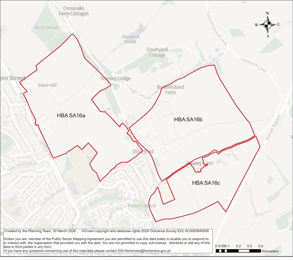
Site Address Well End Strategic Urban Extension, Borehamwood
Site Details This allocation relates to three sites: land to the north of Hertswood Academy (east of Cowley Hill and west of Well End Road); land to the north of Rowley Lane and south of Buckettsland Lane; and land to the south of Rowley Lane. The three sites are comprised of undeveloped land
Planning Designations and Site Considerations
Strategic Urban Extension; Comprehensive strategic development, comprised of higher density residential, social/ community infrastructure, open spaces, main town centre and complimentary employment uses.
Development of these sites has the potential to impact the setting of various listed buildings: The Thatched Lodge (Grade II); two listed buildings at Pursley
Hertsmere Local Plan Draft Regulation 18 Consultation Document
Farm (Grade II); Tomten (Grade II); Wheatsheaf Farm House (Grade II); Buckettsland Farm House and Barn (Grade II); two buildings at High Canons Farm House (Grade II); Barnet Lodge (Grade II); Nelson Cottage (Grade II); Barn south west of Rowley Farm House (Grade II).
Sites near Local Wildlife Sites. A public right of way passes through SA17a and SA17b. Limited surface water and flood zone 2 and 3 areas.
Planning Status HBA SA17c: 22/1526/FULEI: Development of a film and television production studio (Use Class E(g)(ii)) with ancillary floorspace, backlot, new access arrangements, car parking, landscaping, infrastructure and associated works. Appeal allowed. Permission expiring 22 Sep 2028.
Timeframe for Delivery Years 1 – 5 Years 6 –10 Years 11 – 15 Beyond 15 Years
Indicative Development Capacity
Net Residential Units
a 1,523
b 1,425
c 802
Total: 3,750 dwellings
Gross Non-Residential Floorspace
It is anticipated that the comprehensive development of the site as a new strategic urban extension will incorporate an appropriate mix of main town centre, social infrastructure and employment uses. The scale of non-residential uses will be informed through by the master planning of the site.
A strategic urban extension is proposed, which would make efficient use of land and contribute towards meeting the Borough’s housing needs. The development of this site will secure new and improved transport infrastructure, including walking routes and cycle ways, as well as public realm and environmental enhancements, including new public open space and planting.
The development of the candidate site provides an opportunity to secure high-quality townscape and built form that will ensure that this area contributes positively towards Borehamwood’s needs. Proposals in this location would seek to deliver comprehensive strategic development, comprised of higher density residential, social/community infrastructure, open spaces and town centre uses. The delivery of the above aligns with the spatial strategy proposed for the Borough.
Developers will be required to prepare comprehensive proposals that deliver a mix of compatible and complementary uses, and at least the quantum of development specified in the site allocation policy. The delivery of a mix of main town centre, social
Hertsmere Borough Council
Hertsmere Local Plan Draft Regulation 18 Consultation Document
infrastructure and employment uses as an integrated part of the strategic urban extension will ensure that this new place will be partially self-sustaining. Strong infrastructure network connections with Borehamwood will ensure that this becomes a successful and sustainable place. The delivery of a mix of complementary main town centre uses, as defined under Class E, will create a new centre for residents and communities. It is anticipated that this will include compatible and complementary main town centre uses to serve the new community; as defined under Class E (g) (i) (ii) and (iii).
As a strategic site, future proposals must be supported by masterplans, and design codes (if multiple phases are required) evidencing inclusive design. Landowners will be required to demonstrate that they are working positively in partnership to deliver development across the site.
It is anticipated that this strategic urban extension could secure a sustained housing land supply that contributes towards meeting the Borough’s needs across the plan period. Strategic opportunities such as those provide by this candidate site will be necessary for the emerging Local Plan to be found sound when it is subject to examination.
The candidate site has a live consent. It forms part of the Borough’s committed fiveyear housing land supply. The principle of it providing a source of supply that delivers growth is established. On that basis it will become a site allocation.
As a live consent that contributes towards the Borough’sfive-year housing land supply, the Council considers it reasonable to assume that the site will commence and begin to deliver growth and meet needs in a timely manner39. Consents that fail to deliver and consequently require renewal will in the future be assessed against the new Local
39 To make a meaningful contribution to Housing Delivery performance consented housing schemes must deliver within three years of receiving consent.
Hertsmere Borough Council
Hertsmere Local Plan Draft Regulation 18 Consultation Document
Plan. Should that arise, the Council may consider measures that secure greater certainty of timely delivery.
Hertsmere Borough Council
Hertsmere Local Plan Draft Regulation 18 Consultation Document
HBA SA17 Land East of Hartfield Avenue and Fronting onto Barnet Lane, Elstree
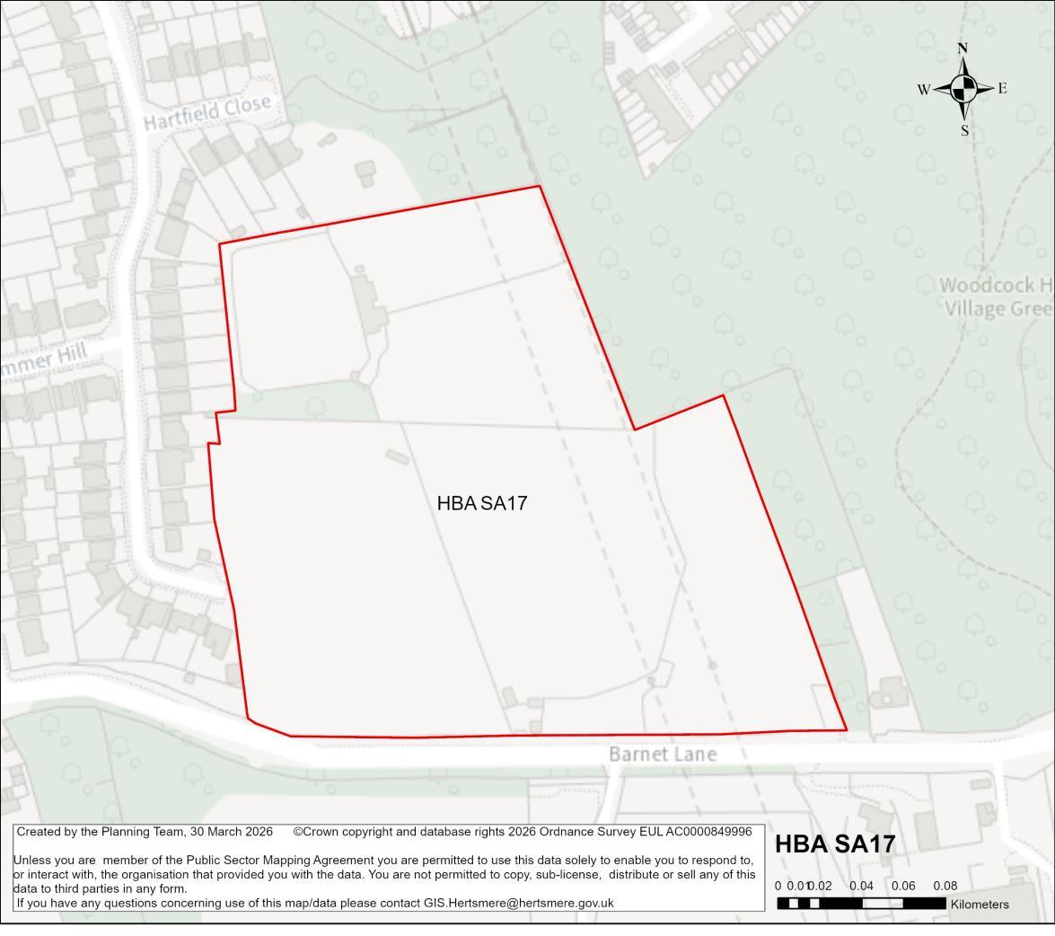
Site Address Land East of Hartfield Avenue and Fronting onto Barnet Lane, Elstree
Site Details The site comprises of undeveloped land to the south of Elstree/Borehamwood and contains part of a newly registered village green.
Site Characteristics Site Size ha 5.77 ha Setting Urban Ownership Private Current Use Open land
Planning Designations and Site Considerations
Urban extension; Development comprised of higher density residential and open space uses
Site is partially above railway tunnels. Local Wildlife Site covering over 50% of the site. A group Tree Preservation Order is partially contained within site. The site contains the registered village green that would be retained and protected as part of this allocation.
Planning Status 23/0053/OUT: Residential development of up to 74 dwellings, with associated landscaping, amenity space, Self-Build plots, sustainable urban drainage
Hertsmere Local Plan Draft Regulation 18 Consultation Document
(SuDs), and associated works. (Outline Application to include Access, with all other matters Reserved).
Appeal allowed. Permission expiring on 25 Mar 2027.
25/1122/REM: Application for the approval of reserved matters relating to layout, scale, appearance and landscaping (including details required conditions 3, 6, 7, 8, 9, 10, and 27), for a residential development of 73 dwellings, with associated landscaping, amenity space, custom and self-build housing plots, sustainable urban drainage (SuDs), and associated works, pursuant to outline planning permission 23/0053/OUT.
Live application pending determination.
Timeframe for Delivery Years 1 – 5 Years 6 –10 Years 11 – 15
Indicative Development Capacity Net Residential Units
74 dwellings based on existing consent
Beyond 15 Years
An urban extension is proposed, which would make efficient use of land and contribute towards meeting the Borough’s housing needs. The development of this site will include walking routes and cycle ways, as well as public realm and environmental enhancements, including new public open space and planting.
The development of the candidate site provides an opportunity to secure high-quality townscape and built form that will ensure that this area contributes positively towards Borehamwood’s needs. Proposals in this location would seek to deliver comprehensive development, comprised of residential development, and open space uses. The delivery of the above aligns with the spatial strategy proposed for the Borough.
Developers will be required to prepare comprehensive proposals that deliver the mix and at least the quantum of development specified in the site allocation policy. As an urban extension site, future proposals must be supported by masterplans, and design codes (if multiple phases are required) evidencing inclusive design. Landowners will be required to demonstrate that they are working positively in partnership to deliver development across the site.
Borough Council
Hertsmere Local Plan Draft Regulation 18 Consultation Document
The candidate site has a live consent. It forms part of the Borough’s committed fiveyear housing land supply. The principle of it providing a source of supply that delivers growth is established. On that basis it will become a site allocation.
As a live consent that contributes towards the Borough’sfive-year housing land supply, the Council considers it reasonable to assume that the site will commence and begin to deliver growth and meet needs in a timely manner40. Consents that fail to deliver and consequently require renewal will in the future be assessed against the new Local Plan. Should that arise, the Council may consider measures that secure greater certainty of timely delivery.
40 To make a meaningful contribution to Housing Delivery performance consented housing schemes must deliver within three years of receiving consent.
Hertsmere Borough Council
Hertsmere Local Plan Draft Regulation 18 Consultation Document
HBA SA18 Land north of Barnet Lane, Borehamwood
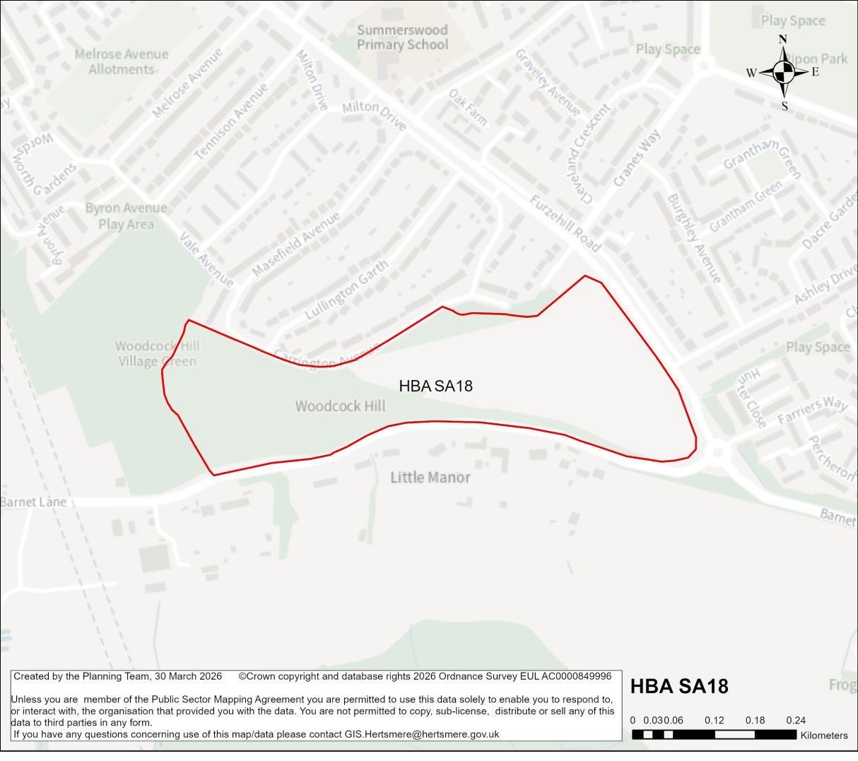
Site Address Land north of Barnet Lane, Borehamwood
Site Details The site comprises a combination of semi improved natural grassland, broad leaved woodland, scrub and amenity/ managed grassed areas.
Site Characteristics Site Size ha 12.55 ha Setting Urban Ownership Private Current Use Pastureland and woodland
Planning Designations and Site Considerations
Urban extension; Development comprised of higher density residential and open space uses (inclusive of retained woodland).
Site encompasses Local Wildlife Site and part of the Woodcock Hill Village Green, which should not be included within the developable area of the site. Large areas of group TPOs. Public right of way exists through the site. Small pockets of surface water flood risk.
Planning Status 23/0937/OUT: Outline planning application for the erection of up to 220 dwellings, including 50% affordable housing, self-build/custom-build plots, green infrastructure (including public open space, play area, landscape planting and
Hertsmere Borough Council
Hertsmere Local Plan Draft Regulation 18 Consultation Document
sustainable drainage systems), ecological enhancements to Woodcock Hill Village Green, new multi-modal vehicular access from Furzehill Road, emergency, pedestrian and cycle access from Carrington Avenue, and associated works and development. Appeal allowed. Permission expiring 27 Nov 2027
25/1554/REM: Application for the approval of reserved matters relating to details of appearance, landscaping, layout and scale pursuant to outline planning permission 23/0937/OUT (granted under APP/N1920/W/24/3346928) for the erection of 220 dwellings and associated open space, hard and soft landscaping, car parking and other infrastructure.
Live application pending determination
Timeframe for Delivery Years 1 – 5 Years 6 –10 Years 11 – 15
Indicative Development Capacity
Net Residential Units
220 dwellings [based on consent]
Beyond 15 Years
An urban extension is proposed, which would make efficient use of land and contribute towards meeting the Borough’s housing needs. The development of this site will include walking routes and cycle ways, as well as public realm and environmental enhancements, including new public open space and planting. The existing woodland on the site will be retained.
The redevelopment of the candidate site provides an opportunity to secure high-quality townscape and built form that will ensure that this area contributes positively towards Borehamwood’s needs. Proposals in this location would seek to deliver comprehensive development, comprised of residential development, and open space uses. The delivery of the above aligns with the spatial strategy proposed for the Borough.
Developers will be required to prepare comprehensive proposals that deliver the mix and at least the quantum of development specified in the site allocation policy. As an urban extension site, future proposals must be supported by masterplans, and design codes (if multiple phases are required) evidencing inclusive design. Landowners will be required to demonstrate that they are working positively in partnership to deliver development across the site.
Borough Council
Hertsmere Local Plan Draft Regulation 18 Consultation Document
The candidate site has a live consent. It forms part of the Borough’s committed fiveyear housing land supply. The principle of it providing a source of supply that delivers growth is established. On that basis it will become a site allocation.
As a live consent that contributes towards the Borough’sfive-year housing land supply, the Council considers it reasonable to assume that the site will commence and begin to deliver growth and meet needs in a timely manner41. Consents that fail to deliver and consequently require renewal will in the future be assessed against the new Local Plan. Should that arise, the Council may consider measures that secure greater certainty of timely delivery.
41 To make a meaningful contribution to Housing Delivery performance consented housing schemes must deliver within three years of receiving consent.
Hertsmere Borough Council
Hertsmere Local Plan Draft Regulation 18 Consultation Document
HBA SA19 Land South of Allum Lane, Elstree
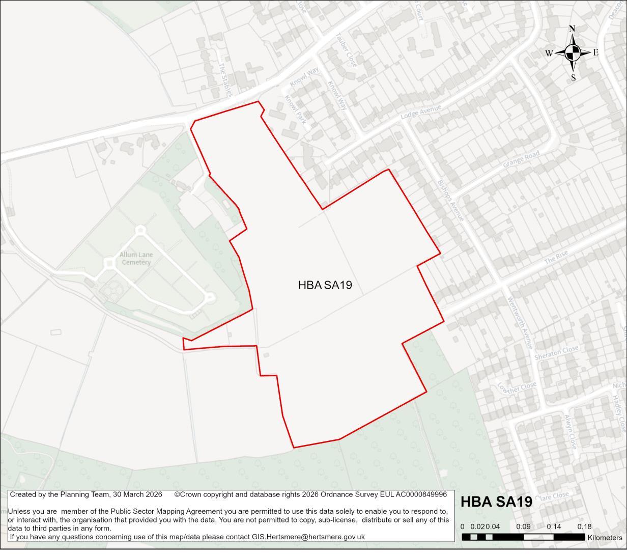
Site Address Land South of Allum Lane, Elstree
Site Details Undeveloped land.
Site Characteristics Site Size ha 10.46 ha Setting Urban Ownership Private Current Use Open land
Planning Designations and Site Considerations
Urban extension; Development comprised of higher density residential and open space uses (inclusive of retained trees, and hedgerows).
Public right way across the site. Tree Preservation Orders present near the edges of the site. Proximity to Archaeological Site (ARCH-17). Development has the potential to impact the setting of two Grade II listed buildings at Nicoll Farmhouse. Limited areas of surface water flood risk, and Flood Zone 2 near the eastern edge of the site.
Planning Status 24/0442/FUL: Development of an Integrated Retirement Community (IRC) including the erection of a retirement living complex (comprising apartment, bungalows and an associated facilities building) a doctors surgery, hard and soft
Hertsmere Borough Council
Hertsmere Local Plan Draft Regulation 18 Consultation Document
landscaping, sustainable drainage systems, highways works including a new access off Allum Lane, and all associated works.
Live application pending determination.
Timeframe for Delivery Years 1 – 5 Years 6 –10 Years 11 – 15
Indicative Development Capacity Net Residential Units 241 dwellings
Non-residential Floorspace
Re-located and re-provided NHS GP Surgery.
Beyond 15 Years
An urban extension is proposed, which would make efficient use of land and contribute towards meeting the Borough’s housing needs. The development of this site will include walking routes and cycle ways, as well as public realm and environmental enhancements, including new public open space and planting. The existing woodland on the site would be expected to be retained.
The redevelopment of the candidate site provides an opportunity to secure high-quality townscape and built form that will ensure that this area contributes positively towards Borehamwood’s needs. Proposals in this location would seek to deliver comprehensive development, comprised of residential development, and open space uses. The development of the candidate site could secure the re-location and reprovision of the NHS GP Shopwick Surgery from Elstree Village. The delivery of the above aligns with the spatial strategy proposed for the Borough.
Developers will be required to prepare comprehensive proposals that deliver the mix and at least the quantum of development specified in the site allocation policy. As an urban extension site, future proposals must be supported by masterplans, and design codes (if multiple phases are required) evidencing inclusive design. Landowners will be required to demonstrate that they are working positively in partnership to deliver development across the site.
Hertsmere Borough Council
Hertsmere Local Plan Draft Regulation 18 Consultation Document
HBA SA20 Parkfields/The Hertsmere Golf Course
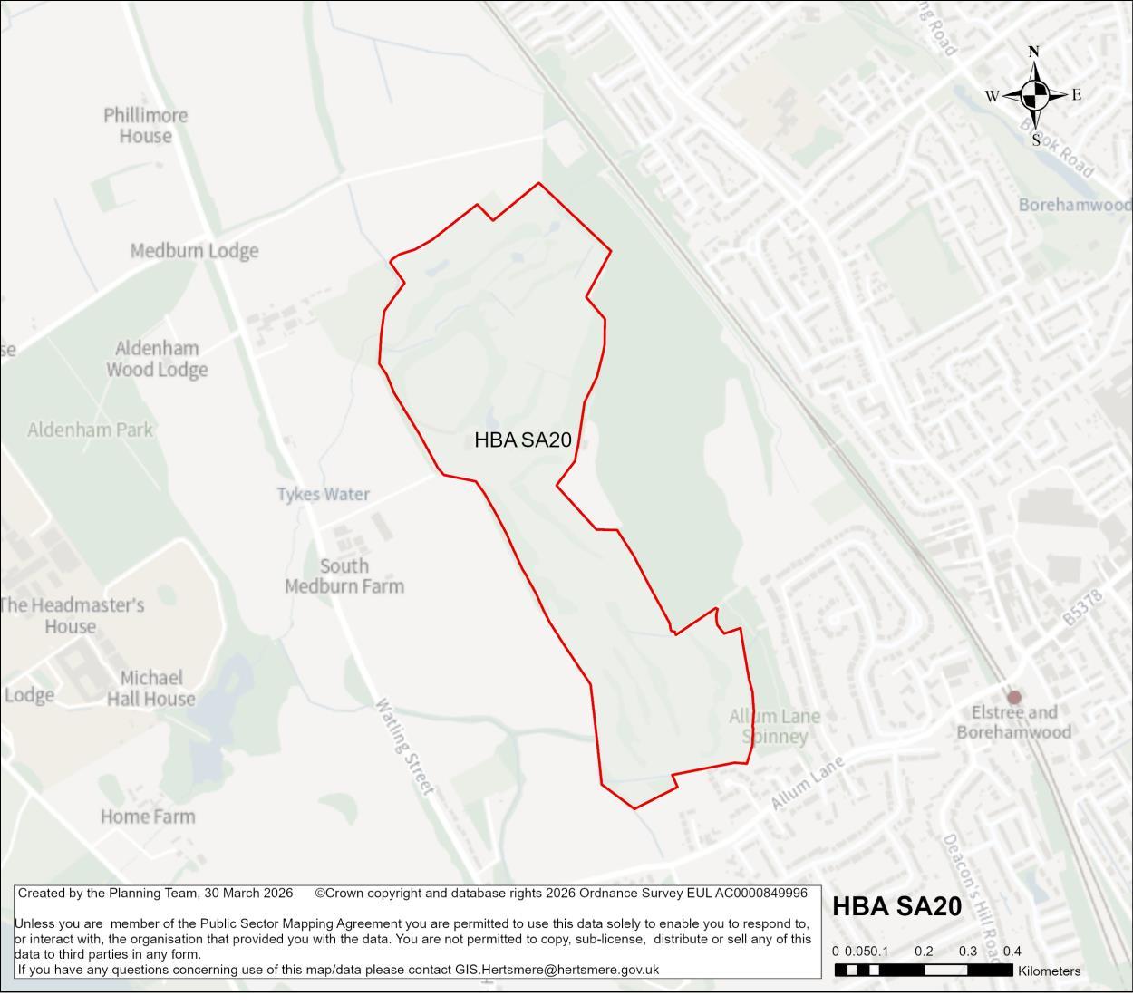
Site Address Parkfields/The Hertsmere Golf Course
Site Details Golf course and parkland
Site Characteristics
Planning Designations and Site Considerations
Site Size ha 46.65 ha Setting Edge of urban area Ownership Public – HBC and Private Current Use Public park/open space and golf course
Urban Extension; Comprehensive strategic development, comprised of higher density residential, social/ community infrastructure, open spaces, and main town centre uses.
Public right of wayacross the site. Individual and group Tree Preservation Orders present. Adjacent to Local Wildlife Site. Pockets of surface water flood risk and limited areas of Flood Zone 2. Proximity to The Waggon and Horses Public House (Grade II listed); South Medburn Farm (Grade II listed); Nicoll Farm (two
Hertsmere Local Plan Draft Regulation 18 Consultation Document
Grade II listed); Allum House (Grade II listed) although separation distances might mitigate impacts. Ecology and Open Space considerations.
Planning Status No recent relevant planning history.
Timeframe for Delivery Years 1 – 5 Years 6 –10 Years 11 – 15
Indicative Development Capacity
Beyond 15 Years
Net Residential Units 1073 dwellings
Gross Non-Residential Floorspace
It is anticipated that the comprehensive development of the site as a new strategic urban extension will incorporate an appropriate mix of main town centre, social infrastructure and employment uses. The scale of non-residential uses will be informed through by the master planning of the site.
A strategic urban extension is proposed, which would make efficient use of land and contribute towards meeting the Borough’s housing needs; comprised of higher density residential, social/community infrastructure, open spaces, and main town centre uses. The development of this site will secure new and improved transport infrastructure, including walking routes and cycle ways, as well as public realm and environmental enhancements, including new public open space and planting.
The development of the candidate site provides an opportunity to secure high-quality townscape and built form that will ensure that this area contributes positively towards Borehamwood’s needs. Proposals in this location would seek to deliver comprehensive strategic development, comprised of higher density residential, social/community infrastructure, open spaces and town centre uses. The delivery of the above aligns with the spatial strategy proposed for the Borough.
Developers will be required to prepare comprehensive proposals that deliver the mix and at least the quantum of development specified in the site allocation policy. As a strategic urban extension, future proposals must be supported by masterplans, and design codes (if multiple phases are required) evidencing inclusive design. Landowners will be required to demonstrate that they are working positively in partnership to deliver development across the site.
It is anticipated that this strategic urban extension could secure a sustained housing land supply that contributes towards meeting the Borough’s needs across the plan period. Strategic opportunities such as those provide by this candidate site will be
Hertsmere Borough Council
Hertsmere Local Plan Draft Regulation 18 Consultation Document
necessary for the emerging Local Plan to be found sound when it is subject to examination.
Hertsmere Borough Council
Hertsmere Local Plan Draft Regulation 18 Consultation Document
HBA SA21 Hollywood Court, Borehamwood
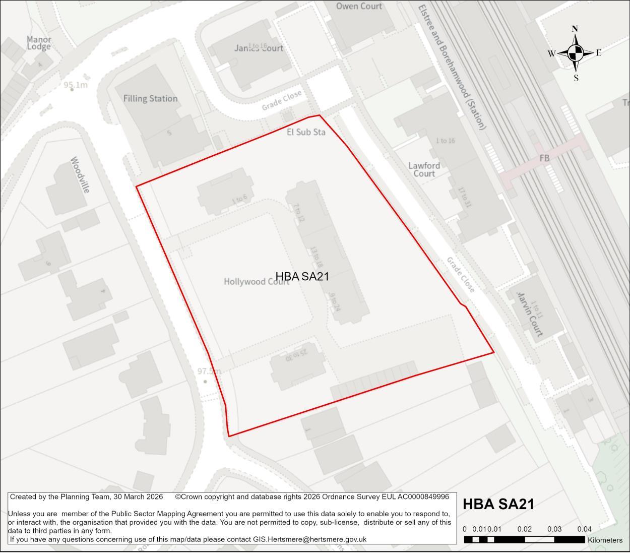
Site Address Hollywood Court, Deacons Hill Road, Elstree
Site Details Existing residential apartments on the site.
Site Characteristics Site Size ha 0.71 ha Setting Urban Ownership Private Current Use Residential flats
Planning Designations and Site Considerations
Urban Site; Comprehensive redevelopment comprised of residential uses (with vertical intensification).
Complicated by potential for individual flats to be in separate leasehold ownerships. Proximity to group Tree Preservation Order. Development has the potential to impact the setting of Grade II listed Manor House.
Planning Status No recent relevant planning history.
Timeframe for Delivery Years 1 – 5 Years 6 –10 Years 11 – 15 Beyond 15 Years
A comprehensive redevelopment is proposed, which will make more efficient use of this sustainable location, and will primarily comprise of residential uses. The regeneration of the site will secure walking and cycling routes, as well as public realm and environmental enhancements.
The redevelopment of the candidate site provides an opportunity to secure high-quality townscape and built form that will ensure that this area contributes positively to Borehamwood’s townscape, and meeting the area’s needs. The delivery of a higher intensity residential accommodation aligns with the spatial strategy proposed for the Borough. This is a suitable location for tall buildings. The design-led approach and masterplanning process will require that future development integrates with the town centre’s wider townscape.
Developers will be required to prepare comprehensive proposals that deliver the mix and at least the quantum of development specified in the site allocation policy. As an urban regeneration site, future proposals must be supported by masterplans, and design codes (if multiple phases are required) evidencing inclusive design. Landowners will be required to demonstrate that they are working positively in partnership to deliver development across the site.
Hertsmere Borough Council
Hertsmere Local Plan Draft Regulation 18 Consultation Document
HBA SA22 Old Haberdasher's Sports Ground - Croxdale Road, Borehamwood
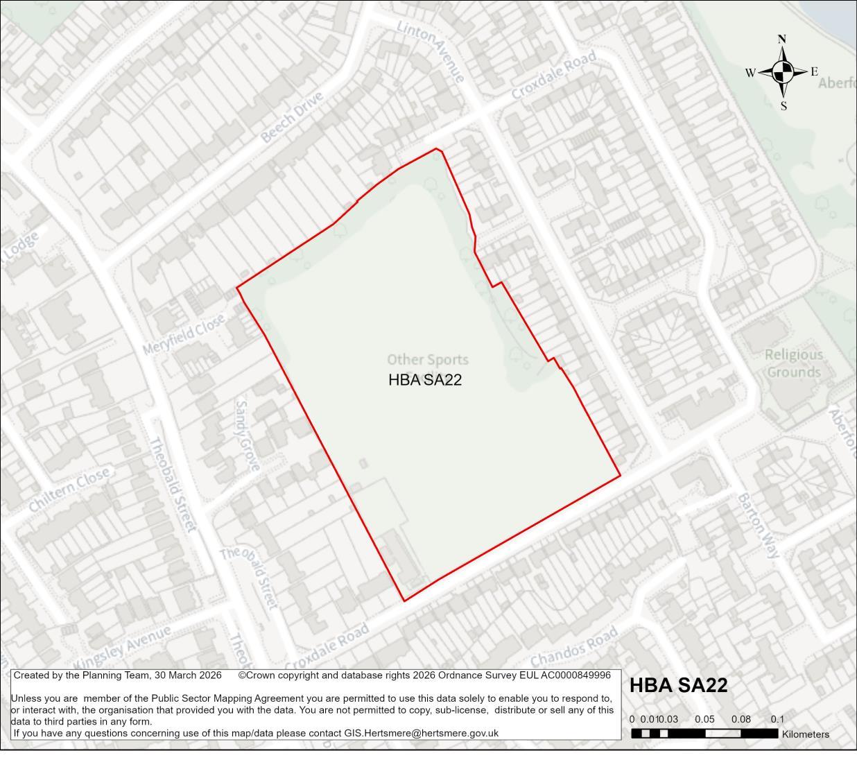
Site Address Old Haberdasher's Sports Ground, Croxdale Road, Borehamwood
Site Details
Site Characteristics
Planning Designations and Site
Considerations
Private sports ground in residential area, characterised by terraced houses and flats.
Urban Site; Comprehensive redevelopment comprised of residential uses (with vertical intensification).
Hertsmere Borough Council
Hertsmere Local Plan Draft Regulation 18 Consultation Document
An alternative site for sports provision might be required. Limited number of individual Tree Preservation Order trees on the site. Some area of surface water flood risk on the north-east corner of the site.
Planning Status 16/0341/FUL 170 residential units (WITHDRAWN)
Timeframe for
Years 1 – 5 Years 6 –10
A comprehensive redevelopment is proposed, which will make more efficient use of this sustainable location, and will primarily comprise of residential uses. The regeneration of the site will secure walking and cycling routes, as well as public realm and environmental enhancements.
The development of the candidate site provides an opportunity to secure high-quality townscape and built form that will ensure that this area contributes positively to Borehamwood’s townscape, and meeting the area’s needs. The delivery of a higher intensity residential accommodation aligns with the spatial strategy proposed for the Borough. This is a suitable location for higher density residential, which may include mid-rise new buildings. Proposals for tall new buildings will need to demonstrate that the surrounding townscape has sufficient capacity for them to be accommodated.
Developers will be required to prepare comprehensive proposals that deliver the mix and at least the quantum of development specified in the site allocation policy. As an urban regeneration site, future proposals must be supported by masterplans, and design codes (if multiple phases are required) evidencing inclusive design. Landowners will be required to demonstrate that they are working positively in partnership to deliver development across the site.
Hertsmere Borough Council
Hertsmere Local Plan Draft Regulation 18 Consultation Document
HBA SA23 Directors Arms, Borehamwood
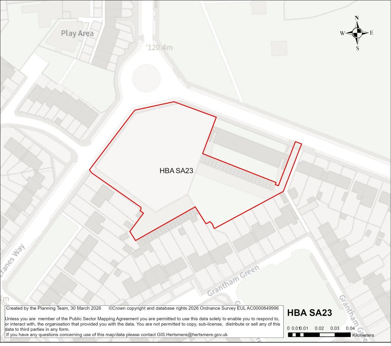
Site Address Directors Arms Public House, Ripon Way, Borehamwood
Site Details Site of former public house, now demolished.
Site Characteristics Site Size ha 0.58 ha Setting Urban Ownership Public – HBC Current Use Vacant (former public house)
Planning Designations and Site Considerations
Urban Site; Comprehensive redevelopment comprised of residential uses (with vertical intensification)
One Tree Preservation Order on the site. No other constraints.
Planning Status 25/0227/FUL: Demolition of 38 garages and redevelopment of the site to provide 29 dwellings and community floor space (Use Class F2) with
Hertsmere Borough Council
Hertsmere Local Plan Draft Regulation 18 Consultation Document
associated landscaping, car and bicycle parking, access and other associated works.
Timeframe for Delivery Years 1 – 5 Years 6 –10 Years 11 – 15
Indicative Development Capacity
Beyond 15 Years
Net Residential Units 29 dwellings
Gross Non-Residential Floorspace
Community use across ground floor
A comprehensive redevelopment is proposed, which will make more efficient use of this sustainable location, and will primarily comprise of residential uses. The regeneration of the site will secure walking and cycling routes, as well as public realm and environmental enhancements.
The redevelopment of the candidate site provides an opportunity to secure high-quality townscape and built form that will ensure that this area contributes positively to Borehamwood’s townscape, and meeting the area’s needs. The delivery of a higher intensity residential accommodation aligns with the spatial strategy proposed for the Borough.
Developers will be required to prepare comprehensive proposals that deliver the mix and at least the quantum of development specified in the site allocation policy. As an urban regeneration site, future proposals must be supported by masterplans, and design codes (if multiple phases are required) evidencing inclusive design. Landowners will be required to demonstrate that they are working positively in partnership to deliver development across the site.
The candidate site has a live consent. It forms part of the Borough’s committed fiveyear housing land supply. The principle of it providing a source of supply that delivers growth is established. On that basis it will become a site allocation.
Hertsmere Borough Council
Hertsmere Local Plan Draft Regulation 18 Consultation Document
As a live consent that contributes towards the Borough’sfive-year housing land supply, the Council considers it reasonable to assume that the site will commence and begin to deliver growth and meet needs in a timely manner42. Consents that fail to deliver and consequently require renewal will in the future be assessed against the new Local Plan. Should that arise, the Council may consider measures that secure greater certainty of timely delivery.
42 To make a meaningful contribution to Housing Delivery performance consented housing schemes must deliver within three years of receiving consent.
Hertsmere Borough Council
Hertsmere Local Plan Draft Regulation 18 Consultation Document
HBA SA24 Land North of Allum Lane and East of Watling Street, Elstree
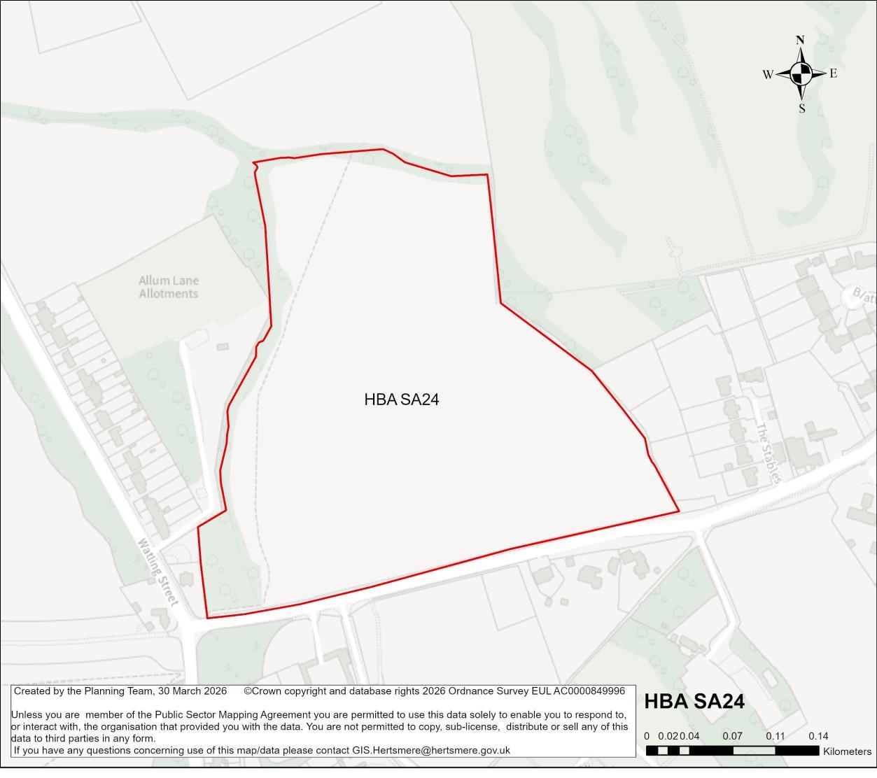
Site Address Land North of Allum Lane and East of Watling Street, Elstree
Site Details Undeveloped land.
Site Characteristics Site Size ha 8.63 ha Setting Edge of urban area Ownership Private Current Use Open land
Planning Designations and Site Considerations
Urban extension; Development comprised of higher density residential and open space uses
A public right of way exists across the site. Proximity to existing Allum Lane allotments Surface water flood risk through the site. Development potential to impact the setting of two Grade II listed buildings at Nicoll Farm.
Planning Status 26/0318/OUT: Outline planning application (with all matters reserved except access) for residential development of 136 dwellings, including affordable housing (Class C3), associated parking, infrastructure, landscaping and open
Hertsmere Borough Council
Hertsmere Local Plan Draft Regulation 18 Consultation Document
space including allotments, and creation of new vehicular access from Allum Lane.
Live application pending determination.
Timeframe for Delivery Years 1 – 5 Years 6 –10 Years 11 – 15
Indicative Development Capacity Net Residential Units 198 dwellings
Beyond 15 Years
An urban extension is proposed, which would make efficient use of land and contribute towards meeting housing needs. The development of this site will include walking routes and cycle ways, as well as public realm and environmental enhancements, including new public open space and planting.
The development of the candidate site provides an opportunity to secure high-quality townscape and built form that will ensure that this area contributes positively towards Borehamwood’s needs. Proposals in this location would seek to deliver comprehensive development, comprised of residential development, and open space uses. The delivery of the above aligns with the spatial strategy proposed for the Borough.
Developers will be required to prepare comprehensive proposals that deliver the mix and at least the quantum of development specified in the site allocation policy. As an urban extension site, future proposals must be supported by masterplans, and design codes (if multiple phases are required) evidencing inclusive design. Landowners will be required to demonstrate that they are working positively in partnership to deliver development across the site.
Hertsmere Borough Council
Hertsmere Local Plan Draft Regulation 18 Consultation Document
HBA SA25 Lyndhurst Farm, Green Street, Borehamwood
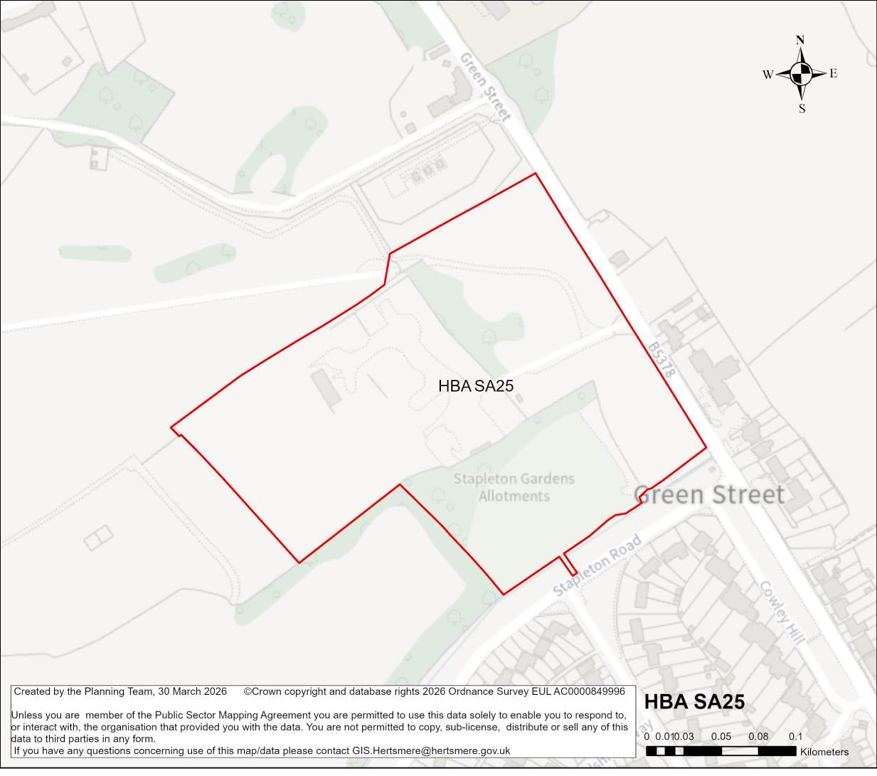
Site Address Lyndhurst Farm, Green Street, Borehamwood
Site Details The site is comprised of existing allotments with associated structures and area of open land.
Site Characteristics Site Size ha 5.27 ha Setting Edge of urban area Ownership Private Current Use Open land and partial allotments area
Planning Designations and Site
Considerations
Urban extension; Development comprised of higher density residential and open space uses.
Area adjacent to Local Wildlife Site. Public Rights of Way present to the south of the site. Gas mains to the north of the site adjacent to the boundary. Limited surface water flood risk and Flood Zone 2 and 3 near the southern boundary of the site. Development has the potential to impact the wider setting of Grade II listed Lyndhurst.
Hertsmere Local Plan Draft Regulation 18 Consultation Document
Planning Status 24/0451/FUL: Full planning application for 186 dwellings, community building, associated parking, landscaping and open space, with vehicle and pedestrian access from Green Street and a separate pedestrian access from Stapleton Road.
Planning permission granted. Permission expiry: 31.03.2028. Construction has commenced on the site.
Timeframe for Delivery Years 1 – 5 Years 6 –10 Years 11 – 15 Beyond 15 Years
Indicative
An urban extension is proposed, which would make efficient use of land and contribute towards meeting housing needs. The development of this site will include walking routes and cycle ways, as well as public realm and environmental enhancements, including new public open space and planting.
The development of the candidate site provides an opportunity to secure high-quality townscape and built form that will ensure that this area contributes positively towards Borehamwood’s needs. Proposals in this location would seek to deliver comprehensive development, comprised of residential development, and open space uses. The delivery of the above aligns with the spatial strategy proposed for the Borough.
Developers will be required to prepare comprehensive proposals that deliver the mix and at least the quantum of development specified in the site allocation policy. As an urban extension site, future proposals must be supported by masterplans, and design codes (if multiple phases are required) evidencing inclusive design. Landowners will be required to demonstrate that they are working positively in partnership to deliver development across the site.
The candidate site has a live consent. It forms part of the Borough’s committed fiveyear housing land supply. The principle of it providing a source of supply that delivers growth is established. On that basis it will become a site allocation.
Hertsmere Borough Council
Hertsmere Local Plan Draft Regulation 18 Consultation Document
As a live consent that contributes towards the Borough’sfive-year housing land supply, the Council considers it reasonable to assume that the site will commence and begin to deliver growth and meet needs in a timely manner43. Consents that fail to deliver and consequently require renewal will in the future be assessed against the new Local Plan. Should that arise, the Council may consider measures that secure greater certainty of timely delivery.
43 To make a meaningful contribution to Housing Delivery performance consented housing schemes must deliver within three years of receiving consent.
Hertsmere Borough Council
Hertsmere Local Plan Draft Regulation 18 Consultation Document
HBA SA26 Organ Hall Farm, Theobald Street, Borehamwood
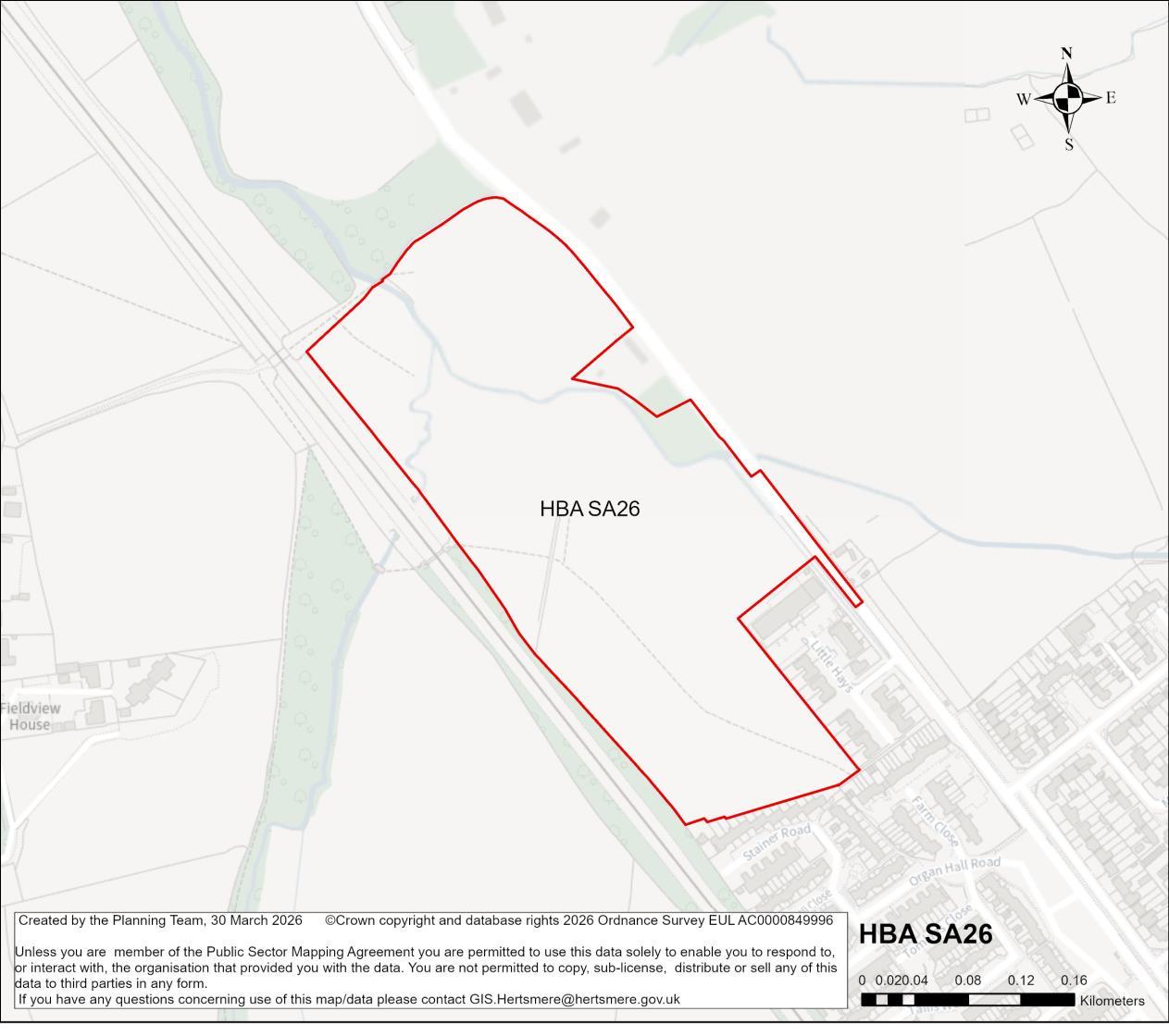
Site Address Organ Hall Farm, Theobald Street, Borehamwood
Site Details The site is comprised of existing allotments with associated structures and area of open land.
Site Characteristics
Planning Designations and Site
Considerations
Urban extension; Development comprised of higher density residential and open space uses.
Flood Zones 2 and 3 flood risk. Public right of way through the site. Gas mains through the site.
Planning Status 22/2149/OUT: Erection of up to 110 dwellings, a medical centre (Use Class E(e)), associated infrastructure, parking, landscaping, open space, earthworks and access from Theobald Street and a change of use of the land edged green
Hertsmere Borough Council
Hertsmere Local Plan Draft Regulation 18 Consultation Document
on Drawing no. 221.1511.103 to provide landscaping and Public open space. (Outline Application to include Access, with all other matters Reserved)
Permission granted. Application expiry date: 02.10.2025
25/1412/REM: Application for the approval of reserved matters relating to layout, scale, appearance and landscaping, for a residential development of 102 dwellings, with medical centre, associated landscaping, amenity space, custom and self-build housing plots, sustainable urban drainage (SuDs), and associated works, pursuant to outline planning permission 22/2149/OUT.
Live application pending determination.
Timeframe for Delivery Years 1 – 5 Years 6 –10 Years 11 – 15 Beyond 15 Years
Indicative Development Capacity
Net Residential Units
110 dwellings
An urban extension is proposed, which would make efficient use of land and contribute towards meeting local housing needs. The development of this site will include walking routes and cycle ways, as well as public realm and environmental enhancements, including new public open space and planting.
The development of the candidate site provides an opportunity to secure high-quality townscape and built form that will ensure that this area contributes positively towards Borehamwood’s needs. Proposals in this location would seek to deliver comprehensive development, comprised of residential development, and open space uses. The delivery of the above aligns with the spatial strategy proposed for the Borough.
Developers will be required to prepare comprehensive proposals that deliver the mix and at least the quantum of development specified in the site allocation policy. As an urban extension site, future proposals must be supported by masterplans, and design codes (if multiple phases are required) evidencing inclusive design. Landowners will be required to demonstrate that they are working positively in partnership to deliver development across the site.