HDN2 – Land south of Five Heads Road LAA Reference Site Size (Ha) Existing Use Proposed Future Use Proposed Number of Homes
HD-004 6.0 ha Agriculture Housing 118
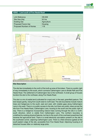
Site Description The site lies immediately to the north of the built-up area of Horndean. There is a public right of way immediately to the south, which connects Catherington Lane to Bridle Path and Five Heads Road. The settlement of Catherington lies to the northwest. A small group of houses borders the site to the northeast, along Five Heads Road. The site is a mix of arable land (cultivated for crops) and, in the east, greenfield pasture. The land slopes gently, rising from south-west to north-east. The site boundaries include mature trees and hedgerows to the south, east and west, with notable gaps along Catherington Lane in the west. There is no public access to the site, but there are public views across the site from Five Heads Road, Catherington Lane, housing to the south and the public right of way. There is a hedgerow incorporating mature trees running through the site in a northsouth direction, which is visible from Catherington Lane. The northern boundary is undefined by existing physical features, but lies to the south of the overhead powerlines that traverse the agricultural land. There is a small electricity sub-station present on the site in the southwest corner, adjoining Catherington Lane. There is a field entrance (gated) at the south-eastern edge of the site, accessible from Five Heads Road. Adjoining housing is of detached houses often on relatively large plots.
Page 397