TRAIL SAFETY TIPS
• Always tell someone when and where you are going.
• Bring maps, along with a compass or GPS device.
• Wear appropriate footwear and clothing, and bring sufficient food and water.
• Carry identification (including name, phone number, and pertinent medical information).
• Bring a portable phone or other communication device, along with pertinent phone numbers.
The way you hike, bike, or ride today shapes the trail access for tomorrow.
Do your part to preserve and enhance by observing the following rules of the trail. These rules are recognized around the world as the standard code of conduct for trail users.
1. Ride on open trails only Respect trail and road closures (ask if uncertain); avoid trespassing on private land; obtain permits or other authorization as may be required. The way you use the trails will influence trail management decisions and policies.
2. Leave no trace. Be sensitive to the dirt beneath you. Recognize different types of soils and trail construction. Wet and muddy trails are more vulnerable to damage.This also means staying on existing trails and not creating new ones. Don’t cut switchbacks. Be sure to pack out at least as much as you pack in.
3. Control your vehicle. Inattention for even a second can cause problems. Obey all speed regulations, guidelines and recommendations.
STOP INVASIVE SPECIES IN YOUR TRACKS
• REMOVE plants, animals and mud from bikes, boots, gear, pets and vehicles.
• CLEAN your gear before entering & leaving the recreation site using BOOT BRUSH provided.
• STAY on designated trails.
4. Always yield to others on the trail. Let fellow trail users know you’re coming. A friendly greeting or bell is considerate and works well; don’t startle others. Show your respect when passing, by slowing to a walking pace or even stopping. Anticipate other trail users around corners or in blind spots.Yielding means slow down, establish communication, be prepared to stop and pass safely.
5. Never scare animals. All animals are startled by an unannounced approach, a sudden movement, or a loud noise. This can be dangerous for you, others, and the animals. Give animals extra room and time to adjust to you. When passing horses use special care and follow directions from the horseback riders (ask if uncertain). Running cattle and disturbing wildlife is a serious offense. Leave gates as you found them, or as marked.
6. Plan ahead. Know your equipment, your abilities, and the area in which you are traveling. Prepare accordingly. Be selfsufficient at all times, keep your equipment in good repair, and carry necessary supplies for changes in weather or other conditions.
JANUARY THRU DECEMBER Trails on Crown Lands are within
• All persons using these trails do so at their own risk
• All persons should wear highly visable clothing
• All persons should keep to the main trails
• Make noise when approaching a curve or uphill climb
• Avoid animal carcasses
• Make dogs visible
Use at your own risk.
• Many trails are NOT MAINTAINED – USE AT YOUR OWN RISK
• Many trails are accessible by ACTIVE or DEACTIVATED LOGGING ROADS requiring 4WD or high clearance vehicles. 2-way radio communication is recommended. Be aware these roads may be closed at certain times.
• PETS! Keep on a leash and clean up after them.
• WATCH FOR WILDLIFE and avoid areas showing recent signs of black bears, grizzly bears, and cougars.
• BEFORE heading out, check with local contacts to make sure the trails and roads are safe.
• BACK-COUNTRY: Check conditions at avalanche.ca
BEWARE! YOU ARE IN BEAR COUNTRY
The Columbia Shuswap Regional District assumes no responsibility for the safety of any persons, animals or equipment when using the trails listed in this guide.
Salmon Arm & Area
Sxwetsméllp means “soopolallie bush” in Secwepemctsín (Secwépemc language) and refers to the area around the confluence of the Salmon River and the southern end of Shuswap Lake within Secwepemcúľecw (territory). Salmon Arm – the area’s largest community – sits in this rolling, fertile valley boasting impressive, thickly forested mountains rising in all directions. It is a splendorous natural setting for a city that retains a rich small-town charm.
1. Aroundthe HillLarch Hills
DISTANCE: 2.5 km (one-way) or 6.5 km (loop)
DURATION: 2+ Hours
ELEVATION GAIN: Moderate
One of the few remaining older growth cedar stands in Larch Hills. The delicately moist mossy forest floor of the Around the Hill trail through old growth cedar/hemlock is for walking only. No bikes or horses. The full Around the Hill Loop links Hemlock Glide, Afterthought, White Pine Walk, and a small section of The Greenway with the Ida View section of the Larch Hills Traverse.
ACCESS: From the Larch Hills Nordic Trails’ North Hub on the Larch Hills FSR west of Cec’s Cabin via White Pine Walk, from the Rubberhead Muffin Top trailhead via
Half Baked, or alternately as part of an extended trip from the South Canoe trailhead via the Ida View Trail on the Larch Hills Traverse.
Wilderness backcountry trail; be prepared and watch for bears. Stay on the designated trail to protect sensitive habitat
2.BADGER PARK
DISTANCE: 700 m
DURATION: Short
ELEVATION GAIN: Minimal
Short trails lead through fir trees to a hidden basketball court tucked behind the houses in this neighbourhood park. A good shortcut for dogwalking to sidestep the busier 20 Ave SE.
ACCESS: Four trail access points: two on 15 St SE, one on 18 Ave SE, and the last on 18 St SE.
8. KLE7scÉñ (MOUNT IDA)
These trails are currently under review as part of comprehensive stewardship planning led by Secwépemc First Nations leadership. The iconic Kle7scén (meaning funny coloured rock in Secwepemctsín and called Mt. Ida by European settlers) towers above Sxwesméllp (meaning soopolallie bush referring to the area called Salmon Arm Bay by settlers). It is an important cultural and sacred area in Secwepemcúĺecw (territory). Leadership from the Secwépemc communities are working with provincial land managers, tenure holders, and local trail stewards to prepare a plan that guides future trails and recreational access, protects sensitive cultural and environmental sites, and engages everyone in taking care of the mountain.
Visit shuswaptrails.com for updates on this important effort of reconciliation.
9. LARCH HILLS
DISTANCE: 170 km (various)
DURATION: 0.5 - 3+ Hours (various)
ELEVATION GAIN: Varies with route
The region’s premier nordic ski area provides 170 km of ski trails (57 km trackset, and 6.5 km lit for night skiing), over 17 km of snowshoe trails,
and is a great destination for hiking, mountain bikes and equestrian riding spring through fall.
Multiple trail options include visits to old growth forest, an interpretative nature loop surrounding one of the area’s many wetland fens, spectacular views over the surrounding valleys on the higher trails, and visits to the South Hub, and Cec’s Cabin just south of Larch Lake. Several longdistance cross-country options for mountain bikers and well-prepared skiers can link routes from the nordic centre. These include connections with Salmon Arm on Metford FSR, the Rubberhead Mountain Bike Network and 110 FSR, or the Larch Hills Traverse to Sicamous.
During the summer a beautiful 4 km forest hiking loop through parts of the Upper Violet Provincial Park links the Moose Trail, Lost in the Woods, and Interpretive Loop snowshoe trails starting at the main chalet. Equestrians will appreciate the large parking and staging area with corrals. Non-winter trail stiles have been added to protect the Upper Violet Provincial Park protected area. skilarchhills.ca
ACCESS: East of Salmon Arm on Hwy 1 turn south on Hwy 97B and drive 8.7 km and then turn left (east) onto Grandview Bench Rd (watch for
the Larch Hills Nordic sign). After approx 5.4 km turn left (north) onto Edgar Rd. After another 3 km, keep left at the junction and travel another 3 km to the Larch Hills ski area parking lot.
Alternate access: Turn north onto Grandview Bench Rd off Hwy 97A west of Grindrod. After approx 3.2 km turn north onto Edgar Rd. Watch for logging vehicles during non-winter months. Many of the Larch Hills Trails are multi-use. Watch for ORVs. Avoid soft wet areas until the ground dries.
10. LARCH HILLS TRAVERSE
DISTANCE: 40 km (one-way)
DURATION: 4 - 10 Hours (one-way) bike; 11 - 14 Hours (one-way) backcountry ski; shorter loop options possible ELEVATION GAIN: Sustained
The Larch Hills Traverse was the first section of the wider Shuswap Trail System to be completed, and is still evolving as new single track trail sections get added, and new loop options are created.
It’s an epic 40 km highland crosscountry romp through the forests, fens, and dramatic lake vistas of the Larch Hills, linking the communities of Salmon Arm and Sicamous, as well as linking into the South Canoe
KARI WILKINSON PHOTO LINDA BUCHANAN PHOTO
#9 Larch Hills
#9 Larch Hills to to
Mountain Bike Trail system, the Hyde Mountain Lookout, the Sicamous Greenway trail system, and the Shuswap North Okanagan Rail Trail. Simply put - it’s the backbone connecting a whole lot of good trail karma in the Shuswap.
The traverse is a four-season challenge, with variations in the winter where more obvious lines open up under snow cover. It’s doable in a very long day by mountain bikers or nordic ski tourers. Overnight option — especially for through hikers.
A series of shorter circuit trips can be linked along the extended route. Together they can be collected over time to build a complete traverse.
You can reserve overnight stays to the Larch Hills Nordic Society’s main Chalet or Cec’s Cabin. Visit skilarchhills.ca for booking info.
SALMON ARM (WEST) TRAILHEAD
ACCESS: Park at the South Canoe trailhead east of Salmon Arm at the end of 10 Ave SE (turn east on 10 Ave SE at the crosswalk on Hwy 97B) and look for the Larch Hills Traverse kiosk at the north end of the parking lot.
SICAMOUS (EAST) TRAILHEAD
ACCESS: See Larch Hills TraverseSicamous Trailhead for details.
LARCH HILLS (SOUTH)
TRAILHEAD: See Larch Hills access to the main Larch Hills Nordic Chalet Parking area.
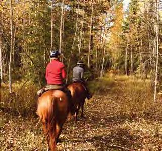
EQ ACCESS: The best access and trailer parking for equestrian riders is at the Larch Hills and South Canoe trailheads.
Careful preparation, adequate food, water, gear, and knowledge of backcountry travel and navigation are essential. Plan accordingly.
11. LARCH HILLS TRAVERSE - IDA VIEW
DISTANCE: 6 - 16+ km (various)
DURATION: 1 - 6+ Hours (various)
ELEVATION GAIN: Sustained
The newest addition to the Larch Hills Traverse also serves as an excellent day hike, snowshoe, cross-country mountain bike, or equestrian ride from Salmon Arm. It is designed as a shared use trail so watch for horses. The trail climbs through the forested slopes past viewpoints looking toward Kle7scéń (meaning funny coloured rock in Secwepemctsín and called Mt. Ida by European settlers) and out over the Sxwesméllp bay area (which means soopolallie bush in Secwepemctsín referring to the area called Salmon Arm Bay by European settlers).
The trail links into Around the Hill, Larch Hills trails, and the upper Rubberhead trail system creating even more creative long distance trail loop options. Or just go for it and continue on to Sicamous (see Larch Hills Traverse).
ACCESS: Start at the South Canoe Trailhead crossing the new East Canoe Creek trail bridge. (See South Canoe Trail System).
12. LITTLE
MOUNTAIN PARK
DISTANCE: up to 8 km (various)
DURATION: 0.5 - 2 Hours (various)
ELEVATION GAIN: Low - Moderate (varies with route)
8 km of wide, smooth, forested
nature trails appropriate for families, and a variety of figure 8 loop options and difficulty levels, including a short climb on Summit trail to the Secwépemc Landmark sculpture, where there are views of Salmon Arm, Salmon Arm Bay, Fly Hills, Kle7scéń (Mt. Ida), and spring wildflowers along the west facing bluffs.
ACCESS: Three trailheads: the east end of Okanagan Ave off 30 St SE in Salmon Arm, the southwest corner of Little Mountain Fieldhouse parking lot on 30 St SE, or just south of 37 St SE on 10 Ave SE. Additionally, there are trails connecting to adjacent neighborhoods.
13. McGUIRE LAKE PARK
DISTANCE: 800 m (around the lake)
DURATION: 0.25 - 0.5 Hour
ELEVATION GAIN: Minimal
A wheelchair accessible, paved path, picnic tables, and plenty of opportunity for waterfowl viewing surround this little lake. Watch for the painted turtles out soaking up the sun on hot days, and visit the Japanese Friendship Gate, a gift from Inashiki, Japan, Salmon Arm’s sister city.
Extend your walk with a visit to the Marine Peace Park and Nature Bay trails via the pedestrian stairway north of the BDO building, or link east to Turner Creek Trail, the Rec Centre, and Little Mountain Park.
ACCESS: Downtown Salmon Arm, east end of Hudson Ave NE, north of Hwy 1.
South Canoe Kid’s
Loop
14. Necalclánk (FLY HILLS) ROTARY SKYVIEW LOOKOUT
DISTANCE: 0.5+ km (various)
DURATION: 0.5 - 2+ Hours
ELEVATION GAIN: Moderate
A short walk to a viewpoint provides outstanding views of Salmon Arm, Shuswap Lake and Salmon River Valley, wildflowers, birds and the extent of the 1998 fires across on Kle7scén (Mt Ida). Learn Secwepemctsín place names at the Necalclánk Secwépemc Landmark sculpture. A loop is possible back to the parking area. Necalclánk (Chase eastern dialect) or Nclcahl (Splatsin dialect) means “Steep Hillside” in Secwepemctsín.
ACCESS: Via Fly Hills FSR #170 west of Salmon Arm off Salmon River Rd. After climbing the FSR steeply through six switchbacks for approx 7.5 kms watch for the parking landing on your left.
Watch for oncoming forestry traffic and ORV use. Winter use is managed by the Snowblazers Snowmobile Club and limited to snowmobile traffic only.
15. PARK HILL TRAIL SYSTEM
DISTANCE: 5 km (various)
DURATION: 0.5 - 1.5+ Hours
ELEVATION GAIN: Moderate
Park Hill offers trail users a variety of singletrack loops for hikers, mountain
bikers, and snowshoers on both the west and east side of Park Hill Rd above Canoe Beach. In the winter, bring your snowshoes or ice cleats. Once everything’s packed down these make great fat-bike loops.
Link to Canoe Beach, the Paddle Centre, boat launch, or ball diamonds at William Baker Park. The Salmon Arm Rowing and Paddling's Paddle Centre is right at Canoe Beach. Link a Blueway paddle with a Greenway hike. shuswaprowingandpaddling.com
ACCESS: Four main access points – one in the overflow parking above Canoe Beach just before the bottom of Park Hill Rd in Northeast Salmon Arm, another halfway up Park Hill Rd at the blue pump house, or start right at the Canoe Beach parking lot (trailhead across the road), or to the east at the Canoe Ball Diamonds.
16. PETER JANNINK NATURE PARK
DISTANCE: 500 m (various)
DURATION: 0.25+ Hour
ELEVATION GAIN: Minimal
A short, pleasant walking loop with shortcut connectors overlooking the wetlands. A packed gravel path makes this trail accessible for all ages. There is a lawn area perfect for picnicking in the summer months. Connect a longer walk with the Salmon Arm wharf, nature trail, walkways, and Foreshore Trail.
ACCESS: Across the railroad tracks from downtown Salmon Arm, follow Beatty Avenue west to Narcisse St NW. Turn right, passing Churches Thrift Store, and park at the end of Narcisse St. Park entrance clearly signed. Alternate access from the end of Hudson St NW.
17. PILEATED WOODS
DISTANCE: 2 km (various)
DURATION: 0.3 - 1.0 Hour
ELEVATION GAIN: Moderate
Part of Salmon Arm’s growing greenway network maintained by residents who live around the park. Handmade interpretive signs have been created by one of the region’s noted biologists and provide a glimpse into the forest ecology.
Look for the Owls Prowl town connector trail for mountain bikes and walking between Auto Rd near the junction with 10 St SE through to Old Auto Rd at 7 St SE.
ACCESS: Travel south along Shuswap St SE from Hwy 1 in Salmon Arm. Turn left/east on 10 Ave SE and watch for the park entrances on the left just past 6 St SE and at the left bend where 10th turns into Auto Rd. Other entrances can be found on the south side of Old Auto Rd.
18. RJ HANEY HERITAGE PARK NATURE TRAIL
DISTANCE: 2 km (round trip)
DURATION: 0.5+ Hour
ELEVATION GAIN: Minimal
Easy to walk, especially for families with strollers and assisted wheelchair exploration. A forest nature trail with interpretive signs, ravine, creek, small bridges, wildflowers, picnic tables, museum, and heritage village. salmonarmmuseum.org
ACCESS: East of Salmon Arm on Hwy 1, turn south at the Hwy 97B junction; entrance on your right.
SAEDS PHOTO
#13 McGuire Lake Park to
19. RUBBERHEAD MOUNTAIN BIKE TRAIL SYSTEM
DISTANCE: 30+ km (various)
DURATION: 1 - 3+ Hours (various)
ELEVATION GAIN: Sustained
Rubberhead started off as a single mountain bike trail that has now expanded into a network of trails including a climbing trail that can be ridden up to the 7 km mark on the FSR #110 via the Rubberhead Traverse, or to the top of the Half Baked trail using the Larch Hills Traverse Ida View section.
The area offers a variety of downhill mountain bike options for intermediate to advance riders. From steep and rooty to open and flowy, this system has something for everyone. The trail system is looked after by the Shuswap Cycling Club. shuswapbike.com
ACCESS: East of Salmon Arm on Hwy 1 approx 4 km past the Canoe Mill, turn onto 110 FSR. The trailhead parking area is 2.5 km on the left. Watch for the kiosk sign.
Use at your own risk. These trails are designed as freeride downhill mountain bike trails; trails may be steep and difficult. Pay attention to signs and difficulty ratings. Hikers should use extreme caution. Always watch for active logging activities.
BIRD HOT SPOTS
The Foreshore Trail, Peter Jannink Nature Park and Pileated Woods provide several viewpoints to watch bird and waterfowl species.
20. SALMON ARM NATURE TRAIL & INTERPRETIVE CENTRE
DISTANCE: 0.2 - 4 km (various)
DURATION: 0.5 - 2+ Hours (various)
ELEVATION GAIN: Minimal
Discover one of the province’s premier migratory estuaries and nesting area of the western grebe.
The bird blind and osprey nest viewing trail is on the west side of the boat launch in front of the Prestige Harbourfront Resort and links to the West Walkway. North America’s longest wooden inland wharf extends out into the estuary and offers numerous vantages for viewing wildlife - watch for the family of otters living under the docks. Spend time better understanding this place within Secwepemcúĺecw at the Sxwetsméllp Secwépemc Landmark sculpture. Extend your walk west by adding a visit to Peter Jannick Nature Park, or east to the Foreshore Trail.
Stop by the SABNES Nature Centre during the summer months and check the bulletin boards yearround for local bird counts and sighting updates. sabnes.org
ACCESS: Park at the Salmon Arm Marine Peace Park on Marine Park Drive in downtown Salmon Arm, on the north side of the railroad tracks (east of the Prestige Inn Resort).
Sensitive riparian habitat — stay on the designated trail. Respect seasonal closures for nesting or flooding.
DOGS: Allowed only on the main trail, on a short leash (max. 2m).
• Not allowed on viewing decks or Christmas Island.
• Not permitted on the main trail from May 1–June 30 (nesting season).
21. SALMON ARM GREENWAYS
DISTANCE: Various
DURATION: 0.25 - 2+ Hours
ELEVATION GAIN: MinimalModerate (varies with route)
Along with the city’s feature trail systems, like the Turner Creek Rotary Trail, Foreshore Trail, Park Hill, Coyote Park, South Canoe, Pileated Woods, and Little Mountain, new greenway links continue to be added throughout the community. These trail corridors create interesting outings and loops for walking and cycling. Watch for the greenway trail signs.
ACCESS: Visit shuswaptrails.com for trail locations, maps and updates.
22. SALMON ARM MEMORIAL CEMETERY TRAILS
DISTANCE: 4.4 km (various)
DURATION: 0.5 - 1+ Hours
ELEVATION GAIN: Minimal- Moderate
Formally established when the new Memorial Cemetery development closed off a popular walking area established when the area was owned by the Department of Defense. You still see the occasional trail marker from those days. The area is now part of the City parks system and features a little pond hidden within the forest.
ACCESS: Find the trailhead entrance on 20 Ave SE south of Auto Rd SE.
Watch for bears. This is a living greenway connector for wildlife.
SABNES PHOTO
NORTH SHUSWAP
Immerse yourself in authentic stories of a rural and resilient existence. This is home to the incomparable Sockeye Salmon run at Tsútswecw Provincial Park (many rivers) and the Adams Lake, Skwlàx te Secwepémcúĺecw (Little Shuswap Lake), and Neskonlith who together are the Yucwmenlúcwu (caretakers) of the area. You’ll find an unpretentious, quirky North Shuswap culture welcoming visitors all yearround. Pebble beaches, acres of lake, miles of back-country trails, amazing waterfalls and some really good homestyle cafés and bakeries.
28. ALBAS FALLS
DISTANCE: 350 m (one-way to beach); 3.7 km (waterfall loop)
DURATION: 1 Hour (round trip)
ELEVATION GAIN: Moderate
This Shuswap Lake Marine Park loop trail follows both sides of Celista Creek through a series of five impressive waterfalls. bcparks.ca
ACCESS: Approx 32 km north of St Ives on the Seymour Main FSR to Seymour Arm, watch for the Albas Provincial Park sign on the right. Turn right down the rough FSR. 1.6 km down this road, stay right and park where the road widens. Access the trail from the lake at Steamboat Bay and take the trail up to the loop.
Steep, rough sections with sharp drop-offs. Children should be closely supervised and pets kept on a leash. Serious injuries and deaths have occurred.
29. copper island
DISTANCE: 3 km (round trip)
DURATION: 1 Hour (round trip)
ELEVATION GAIN: Moderate
This loop trail to the summit of the sole island in the Shuswap Lake provides panoramic views of the lake and Blind Bay. bcparks.ca
ACCESS: Take the SquilaxAnglemont Rd exit off of Hwy 1 and follow for approx 18 km to Scotch Creek to Shuswap Lake Provincial Park. Copper Island is located 2 km offshore. Boat to the east side of the island to a small beach and trail signs. Steep cliffs. No camping or fires permitted on the island. Water access only.
NORTH
30. crowfoot mountain and mobley lookout
DISTANCE: 5.5+ km from top of Sheep Track to Crowfoot Meadows; additional 6 km from Crowfoot Meadows to Mt Mobley
DURATION: Hiker: 2+ hours (one-way) from top of FSR to Crowfoot Meadows; additional 2 hours (one-way) to Mt Mobley.
ELEVATION GAIN: Sustained
This is a historic route important to the Secwépemc communities, that became an access route to the Big Bend Goldrush, sheep herders, foresters, and, more recently, recreational enthusiasts. Managed in the winter by the Crowfoot Snowmobile Club under authorization of Recreation Sites and Trails BC, the route leads to the rolling subalpine meadows on Crowfoot and Mobley Mountains. In the summer it makes an outstanding hike or mountain bike to views of the surrounding Shuswap highlands.
ACCESS: 2 km east of Celista on Squilax-Anglemont Rd, turn north onto Beguelin Rd. Turn right at the stop sign at the end of Beguelin Rd onto Line 17, then take the next left onto Garland Rd. Proceed 2.6 km until Garland Rd becomes 730 FSR at the first turn and set odometer
to zero. Watch for logging trucks. Follow the main road for approx 1.7 km, then take the right fork. At 2.2 km cross a bridge and continue up the hill staying on the main road for another 8 km climbing high above the lake until a “Deactivated Road” sign signals the junction with the 4WD Sheep Track at 11 km. Park here for a walk up to the meadows and back (11+ km return), or a crosscountry mountain bike ride up to Mobley Lookout and back (approx 20 km return).
NOTE: Protect the delicate flora and fauna of this area by staying on established tracks. Area is a popular ATV destination in the summer.
Be well prepared - this is remote backcountry with grizzly habitat. There is a range license in the area. Avoid disruption to cattle herds. Watch for forestry activity on the lower access.
31. EVELYN FALLS
DISTANCE: 3 km (round trip)
DURATION: 2+ Hours (round trip)
ELEVATION GAIN: Moderate
A little out-and-back trail that explores the North Shuswap forest above Anglemont and leads to a hidden waterfall. Link your visit to a picnic and swim at Lakeview Park.
ACCESS: Approx 41.6 km north of Hwy 1 on Squilax-Anglemont Road, turn north onto Golf Course Rd. Trailhead parking is just past the Fire Hall on the right. Please only use the marked trail. Access through the private air strip is prohibited.
Stay on the trail. Do not climb around the falls. Slippery rocks, steep ledges & sensitive habitat.
32. FARRELL’S FIELD
DISTANCE: Varioius
DURATION: 0.25 + Hour
ELEVATION GAIN: Minimal
A series of nature trail loops hidden in the forest beside the skating rink above Celista next to Hlina Creek. Watch for old interpretive nature signs.
ACCESS: From Squilax-Anglemont Rd at the North Shuswap Elementary School in Celista, turn north onto Meadow Creek Road. Watch for the skating rink and trailhead on your right 2.2 km up Meadow Creek Rd.
SHUSWAP TRAIL ALLIANCE PHOTO
37. seymour river falls
DISTANCE: 200 m
DURATION: 0.5 Hour
ELEVATION GAIN: Minimal
Old growth cedar forest, spectacular falls and a canyon.
ACCESS: Follow the Celista-Seymour FSR past the Seymour Arm townsite. At the 15 km marker cross the Seymour River and stay left at the intersection on the other side of the bridge. Approx 200 m past the bridge, park at the wide spot in the road. Look for the mini map and markings on the west side of the road and follow the short trail down to the falls.
Exercise extreme caution and stay back from edges.
38. shuswap lake provincial park
DISTANCE: 5.2 kms (various)
DURATION: 0.5+ Hour
ELEVATION GAIN: Minimal
Numerous trails in the park, including an interpretive trail and strolls along the lakeshore. Link up with the Scotch Creek Greenway. Many of these trails are suitable for cross-country skiing and snowshoeing when there’s enough snow. bcparks.ca
ACCESS: Find the park entrance 18 km north of Hwy 1 on the SquilaxAnglemont Rd in Scotch Creek.
39. TSúTSWECW provincial park
DISTANCE: 6.4 km (various)
DURATION: 0.5 - 1 + Hours
ELEVATION GAIN: Minimal - Moderate (Varies with route)
A network of trails along the Adams River, located between Adams Lake and Shuswap Lake. River views, forest, wildflowers, mosses, ferns, wildlife, interpretive trails and site of the world-famous four year sockeye salmon run celebrated with the Salute to the Sockeye festival.
Tsútswecw means place of many rivers in Secwepemctsín, referring to the tributaries that make this such a fertile salmon spawning area. It is a significant area for Secwépemc communities and their caretaker relationship to the lands and waters. Please stay on designated trails and respect directional and interpretive signage.
The Lower Trail System encompasses all the trails south of SquilaxAnglemont Rd and provides access to the viewing areas during the October salmon runs. Of special interest are the interpretive centre and Secwépemc Landmark sculpture, the universal access walkway and viewing deck, and the story trail created by Secwépemc youth working with elders. QR coded posts link mobile phones to brief audio interpretive stories.
Unfortunately, the upper trail system and sections of the lower trail system were severely damaged during the 2023 wildfires and are closed. Visit shuswaptrails.com
and bcparks.ca for updated closure information.
For more information, visit bcparks. ca and salmonsociety.com.
ACCESS: Approx 5 km north of Hwy 1 on Squilax-Anglemont Rd. The main day-use parking is across the bridge 1 km on the right. The Wade Road and Upper Flume parking areas are closed due to wildfire damage.
Wildfire hazards persist in fire-affected areas of the park, in particular west of the plaza parking lot, and these areas remain closed to public access. Danger trees, landslides, rock falls, damaged trails, increased water runoff, flooding, and damaged facilities can be expected.
BIRD HOT SPOTS
Tsústwecw Provincial Park trails provide several viewpoints to watch bird and waterfowl species interact in nature.
VIKTORIA HAACK PHOTO
#39 Tsútswecw Provincial Park
CHASE & AREA
From Chase, you can explore Little Shuswap Lake, Neskonlith, Chase Creek, Turtle Valley, the South Thompson River Valley and the Adams Lake areas. Authentic Secwépemc culture excursions start here. Take in a pow wow, taste the food, and go on a canoe journey, or experience a healing ceremony in a sweat lodge. The Village of Chase blooms with seasonal flower baskets, specialty stores, art and culture venues. Stop into a café for a latté, a bannock taco or pick up fresh bread and treats for a picnic.
40. chase creek falls
DISTANCE: 237 m (one-way)
DURATION: 0.25 Hour (round trip)
ELEVATION GAIN: Minimal
A short, accessible trail to dramatic falls. Rest under sweeping cedars while you admire the falls and learn about Secwépemc culture at the Stelteglxús Secwépemc Landmark sculpture. Look for Rocky Mountain bighorn sheep on the slopes above. For a longer walk, connect across the bridge to the Scenc ckwimeméws (Scatchard Mtn) Trails.
ACCESS: Traveling west on Hwy 1 to Chase, turn right (north) onto Shuswap Ave. Turn left (southeast) on Coburn St, then left (north) onto Poquette Rd. Directly after crossing the bridge, park at the trailhead on the right. The trail passes under the highway bridge.
41.
chase
your visit with a trip up the historic Scatchard Mountain Switchbacks and a visit to the beach.
ACCESS: Traveling west on Hwy 1 to Chase, turn right (north) onto Shuswap Ave and drive to the Museum at the corner of Okanagan Ave. Ask for a copy of the Chase Historic Walking Tour brochure. Alternatively, drive through town and enquire at the Visitor Centre on the west end of Shuswap Ave.
42. neskonlith meadows
DISTANCE: Various DURATION: Various ELEVATION GAIN: Moderate
HISTORIC WALK
DISTANCE: Various
DURATION: Various
ELEVATION GAIN: Minimal
A walk back in time through the colourful history of Chase. Combine
Early spring floral displays along a rolling grassland bench above the mouth of the South Thompson River. The Neskonlith Meadows are within Adams Lake First Nations lands. Access is regulated by permit only. Permits are available at the Adams Lake Band Office (see access description) or adamslakeband.org. Seasonal closures apply.
ACCESS: From downtown Chase, follow Pine St north across the South Thompson Bridge. Turn right just
after the bridge and up to the Adams Lake Band Offices immediately on the right. Enquire at the reception office regarding seasonal closures, to purchase a permit, and for directions to the meadows.
43. nIskonlith lake PRoVINCIAL PARK
DISTANCE: Various
DURATION: Various
ELEVATION GAIN: Minimal
Enjoy the beauty of this tranquil lake. Walk along the shore in the Provincial Campground and find some hidden trails through the forest. Also, a lovely place to paddle and watch osprey fish. bcparks.ca.
ACCESS: From Downtown Chase follow Pine St across the tracks and the bridge. Travel west along this gravel road for 3 km where you will come to a fork. Take the right fork
NISKONLITH or NESKONLITH?
Niskonlith is the spelling used on BC Parks provincial maps. Neskonlith is the local Secwépemc spelling of the area.
NORTH
onto Loakin-Bear Creek Rd. You will be rewarded here with a spectacular view of Little Shuswap Lake, the villages of Chase and Adams Lake First Nations, and the South Thompson River. Stay on this road for approx. 3 km. Watch for the park entrance on your left. Another 2 km brings you to the lake and campground.
44. senc ckwimemÉws - scatchard mountain switchbacks
DISTANCE: 4.5 km (one-way)
DURATION: 1+ Hour (one-way)
ELEVATION GAIN: Moderate
This historic switchback trail follows the old road from the southeast corner of the Chase Cemetery and climbs to viewpoints overlooking Chase, Chase Creek Canyon, and further on to Chase Creek Rd. Watch for Rocky Mountain bighorn sheep across the canyon on the slopes above Chase Creek.
Scenc ckwimeméws (meaning rocky narrow path in Secwepemctsín) is a side trail developed with Secwépemc leadership to showcase ongoing Secwépemc and European settler history in the area and is found approx 350 m up the old road on the right (west). It passes over an old, abandoned, roadbed hand-built in the 1900’s from large rocks with many discarded settler artifacts – inviting reflection on the path of reconciliation ahead within Secwepemcúľecw and the challenge to take better care of the land.
Further up the trail, hikers are rewarded with views over Little Shuswap Lake and the Village of Chase. Take a side trail to Odin’s Lookout to search the opposite hillsides for glimpses of bighorn sheep. Another side loop follows the original switchbacked road known as Attila’s Lane. Return the way you came, or, for a loop, drop down Chase-Falkland Rd to Hwy 1 and return to Chase.
ACCESS: Start in the Safety Mart parking lot on the north side of Hwy 1 in Chase and walk through the new underpass below the highway. Alternately, drive on Brooke Dr to the trailhead parking by the cemetery. Watch for a new access path from the Chase Creek Falls trailhead over the bridge.
45. skmana lake trails
DISTANCE: 14 km (XC ski); 3.5 km (snowshoe)
DURATION: 0.5 - 2+ Hours (round trip)
ELEVATION GAIN: Moderate
A series of Nordic ski loop trails and a growing series of snowshoe trails maintained by the Skmana Ski Club surrounding beautiful wetlands and intimate twin lakes. There are 14 km of cross-country ski trails and 3.5 km of designated snowshoe trails. A winter warming hut provides a cozy place to gather pre and après ski. Trail use fee: by donation to the Skmana Ski Club at the trailhead kiosk map just in from the parking area. For more information visit ski-skmana.com.
In the summer, visit for hiking, mountain biking, horseback riding, and camping. Equestrians should avoid trails around the lake as they get wet in the summer.
Visit the Skméne Secwépemc Landmark sculpture by the lake any time of year to learn nearby Secwepemctsín place names.
ACCESS: From Downtown Chase, follow Pine St across the tracks and the bridge. Travel west along this gravel road for 3 km then take the right fork onto Loakin-Bear Creek Rd. Stay on this road for another 10 km until you pass under the B.C. Hydro transmission lines. Watch for the Skmana Ski signs on the left and park at the Recreation Site.
Travelling from the east, turn left onto Squilax-Anglemont Rd and continue 3.9 km, crossing the Squilax bridge, and turn left onto Holding Road. Continue for 4.3 km then turn left on Loakin-Bear Creek Rd and drive another 10 km. Watch for the Skmana Ski signs on the right and park at the Recreation Site.
For detailed maps...
Get a copy of the Shuswap Nordic Map available at local visitor centres, or online at shuswaptourism.ca
SHUSWAP TRAIL ALLIANCE PHOTO #44 Senc ckwimeméws / Scatchard Mountain Switchbacks to
falkland & AREA
Come relax in the small, tranquil communities straddling the overlapping territories of Secwépemc and Syilx/Okanagan Nations, where life is full and the pace is deliciously relaxed. It’s recognized as a farming and ranching community, home to the century old Falkland Stampede, but roadside pathways, forested grassland trails, rocky vistas, and cycle touring routes through the peaceful rural setting are all part of the story here.
46. estekwalen MOUNTAIN
DISTANCE: 7+ km (round trip)
DURATION: 4 - 5 Hours (round trip)
ELEVATION GAIN: Sustained & Exposed
A rigorous wilderness trail for fit, experienced hikers. Several exposed areas require comfort with scrambling, heights, and using ropes to descend loose trail. The trail is approx 7 km round trip (including the lookout spur trails), with an additional 3 km of wilderness routes in the alpine. The trail starts in the forest then climbs into the alpine with wildflowers, steep cliffs, and tremendous views of Paxton Valley and the Monashee Mountains to the east. Along the lower forestry roads there may be cattle in the area, so please remember to leave cattle gates as you find them.
For maps and more information visit vernonoutdoorsclub.org
ACCESS: From Falkland, drive 1 km west on Hwy 97. Just past the Falkland Stampede grounds, turn right onto Wetaskawin Rd headed towards the landfill. Stay left above the landfill site on Rob Roy FSR. At 2.7 km stay left. Continue up switchbacks, going uphill for the next 7 km. The incline can be very slippery when wet, even for 4WD vehicles. At 7.2 km a sign indicates parking and the trailhead on your right.
Wilderness Trail. Route finding is required on the upper slopes, ridge, and descent, with some exposed scrambling. The weather can change quickly so bring extra clothing and be prepared for wilderness travel.
NORTH
47. glenemma TRAILS
DISTANCE: 11+ km (various)
DURATION: 1 - 3+ Hours (various)
ELEVATION GAIN: Moderate - Sustained
Explore drier south facing Interior Douglas fir forests at the newest authorized, signed, and maintained trail system. A multi-use trailhead staging area for motorized and nonmotorized recreational users features dedicated ORV loading and a novice ORV play area. Signed motorized access routes up into the Kelly Mtn area are currently being planned. Hikers, mountain bikers, and equestrian trail users are directed to a series of established non-motorized trail loops south of the trailhead staging area. A dedicated nonmotorized equestrian trail up into the Kelly Mountain area helps to manage ORV/equestrian access in and out of the trailhead.
ACCESS: North of Hwy 97 off Salmon River Rd, take Yankee Flats Rd west at the junction with Heywood Armstrong Rd, then turn left (south) off the second switchback onto McTavish Rd. At approx 750 m turn right (north) up Kelly Main FSR to the trailhead staging area approx 200 m on your right (north side of the FSR).
Important cattle range land and sensitive interior
Douglas fir grassland habitat. Stay on designated trails, roads, and tracks, stay out of wet areas, follow all etiquette signage, avoid disturbing cattle, limit use during high fire seasons. Prevent invasive plants by cleaning your boots, hooves, and tires at the trailhead.
48. HAINES creek
DISTANCE: Various
DURATION: Various
ELEVATION GAIN: Sustained
Multi-use recreational trails are maintained primarily by local offroad motorbike trail riders and for access to the region’s main climbing crags. Forest and creek views, plus good vistas over Salmon River from the climbing crags higher up. This is also the southern end of the Silver Creek Greenway.
ACCESS: From Salmon Arm, head west on Hwy 1 to Salmon Valley Rd. Follow for 18.5 km, past the Silver Creek store and the 7th Day Adventist Church. Turn left at the community playing field /park, just before the Silver Creek Fire Hall. At the ‘T’ intersection by the gravel pit, turn left and travel 3 km
This is a popular off-road area. Watch for motorcyclists and ATVs.
49. lisa road trail
DISTANCE: Various
DURATION: 1.5 Hours (round trip)
ELEVATION GAIN: Moderate
Old logging road that leads up for approx 60 minutes to a serene environment. Terrific views of the surrounding hills, valleys, and fields, wildflowers, berries, small pond.
ACCESS: From Falkland travel approx 12 km northwest on ChaseFalkland Rd to just past (north) of Pillar Lake Resort’s main entrance, then turn right (east) onto Lisa Creek FSR, cross the cattle guard and turn back and park along the fence to the trail. Yellow ribbons mark where to turn left and then it dead ends.
DETAILED MAPS & TRAILHEAD ACCESs
Access detailed maps, trailhead directions, GPS downloads and trail updates @ shuswaptrails.com
SHUSWAP TRAIL
PHOTO
PHOTO
#47 Glenemma Trails
#48 Haines Creek
50. silver creek greenway
DISTANCE: 3.5 km (one-way)
DURATION: Walk 1.5+ Hour (round trip); Bike 0.5 Hour (round trip)
ELEVATION GAIN: Minimal
A beautiful rural parallel greenway path along Salmon River Rd connecting the Silver Creek Store, library, school, and community centre on the north to the Silver Creek Community Park ball diamonds, picnic area, equestrian ring, and ice-skating rink to the south. The path is asphalt surfaced making it wheelchair friendly and ideal for family strolls and bicycles. (Also see Haines Creek).
ACCESS: The best trailhead parking is at Silver Creek Community Park 15 km south of Salmon Arm (3.5 km south of the Silver Creek Store) on Salmon River Rd.
51. tuktakamin mountain
DISTANCE: 4.7 km (round trip)
DURATION: 5 - 6 Hours (round trip)
ELEVATION GAIN: Sustained
A circuit route of mixed forests, ridgelines, vistas, and wildflowers overlooking Falkland.
The trail starts on the left (north) side of the maintenance road, climbing steeply up through the forest to emerge on the open ridgeline, climbs eastward toward the obvious summit of Tuktakamin with its array of radio towers, then loops down a roughly flagged trail found by exploring the western slope below the towers. It drops through the trees steeply and meets the maintenance road continuing a short walk further down the road where it climbs another ridge before dropping steeply back into the forest. Watch for occasional blaze markers. The trail emerges onto the maintenance road just below (west) of the starting point. A short walk back up the road returns you to your vehicle. For maps and more information visit vernonoutdoorsclub.org
ACCESS: 10 km west of Falkland on Hwy 97 turn left (south) onto Old Pinaus Lake Rd, a deactivated logging road. After climbing approx 4 km turn left (east) towards Tuktakamin Mtn and follow signs to the trailhead partway up the maintenance road on the left. The maintenance road can be driven to the top of the mountain and lookout.
ALTERNATE ACCESS: 14 km west of Falkland on Hwy 97 turn left (south) onto Ingram Creek FSR. Drive approx 6.5 km on this active logging road, then left onto Will Lake FSR, following signs to the trailhead. Scrambling on open ridges. Route finding required.
SHUSWAP TRAIL ALLIANCE PHOTO
ROGER BEARDMORE PHOTO
#49 Silver Creek Greenway
#46 Estekwalen Mountain
SOUTH SHUSWAP
Surrounded on three sides by water in the heart of the Lakes region of Secwepemcúĺecw (territory) of the Secwépemc people, the South Shuswap is a lake destination and more. In the summer, there are lake views, highland vistas, boat launches, beaches, and trails to enchanting cliffs, creeks, and waterfalls. In the winter, enjoy snowshoeing, sleigh rides, and ice fishing. Don’t forget to explore the burgeoning cultural scene; visit awardwinning cool climate wineries, preserved railway era buildings, and waterfront dining.
BIRD HOT SPOTS
White Lake, Skimikin Lake, and Loftus Lake provide several viewpoints to watch bird and waterfowl species.
52. BALMORAL TRAIL SYSTEM
to
DISTANCE: 0.5 - 4 km round trip
DURATION: 1 + Hours round trip
ELEVATION GAIN: ModerateSustained; varies with route
A great place for shorter loop options that weave up through forests to the old growth fir tree and Balmoral Bluffs viewpoint. Also, the Balmoral Trail System connects with the Blind Bay Bluffs and the White Lake Traverse trail systems for longer traverse hikes over to White Lake (8 km one-way) or to Blind Bay Bluffs lookout (6 km one-way).
ACCESS: Approx 9.3 km east of Sorrento, or approx 24 km west of Salmon Arm, turn north onto Balmoral Rd. Follow for 1.5 km; watch for the large trailhead parking lot on the right (east) just before Alpen Paradies subdivision.
Trails beyond the Balmoral Trail Loops take you to hiking routes requiring additional preparation, including water.
53. Blind bay BLUFFS
DISTANCE: 6.5 km (one-way)
DURATION: 2.5 Hours (one-way)
ELEVATION GAIN: Sustained
A mix of smooth singletrack and ORV shared doubletrack that leads through quiet forests with peek-a-boo views up to a ridgeline of bluffs with a series of spectacular western vistas.
From the Balmoral Trail System trailhead, head up the Ridge Trail to the Balmoral Bluffs viewpoint, then continue up the Upper North trail, staying left at the trail intersections.
Watch for signs for Blind Bay Lookout at key junction points as the singletrack trail meets and leaves sections of shared ORV trails. Return the way you came or make a shuttle trip by leaving a vehicle at the McArthur Heights trailhead (8 km one-way from McArthur Heights to Balmoral trailheads).
ACCESS: See Balmoral Trail System. Steep bluffs. Stay clear of edge. Wilderness trail, be prepared. Make noise for Bears.
SOUTH SHUSWAP
LINDA BUCHANAN PHOTO
#67 Skemíke Trails
70. WHITE LAKE LOOKOUT
DISTANCE: 2.5 km (one-way)
DURATION: 0.5+ Hour (one-way)
ELEVATION GAIN: Sustained
Originally built as a downhill mountain bike trail - it is a short, steep hike to a lookout with views of White Lake, Little White Lake, Tappen Valley, and Mt Ida in Salmon Arm. The total trail length is 2.5 km long, but the best viewpoint is only 1 km from the bottom of the trail.
At the first lookout, take a moment at the memorial plaque placed in honour of Jonathan Halper, a local mountain biker who loved this trail, and be sure to sign the locally maintained trail register. Watch for chocolate lilies, glacier lillies, and arnica in the spring.
For a longer mountain bike loop (9 km), take the ORV route on the White Lake FSR above John Evdokimoff Park, staying right at first FSR junction and continuing approx 3.8 km. At the junction take the skid road to the right climbing to a ridge line for another approx 2.8 km to the forestry landing and viewpoint knoll. From here ride the White Lake Lookout trail downhill to complete the loop.
ACCESS: See John Evdokimoff Park.
Steep narrow sections. Watch for other trail users. Mountain bikers check your speed.
71. WHITE LAKE PROVINCIAL PARK
DISTANCE: 1.2 km (one-way)
DURATION: 0.5+ Hours (one-way)
ELEVATION GAIN: Minimal
A footpath west along White Lake allows walkers to savour the natural beauty on the edge of this ecologically important area. Stay on the trail to protect the delicate foreshore habitat. bcparks.ca.
ACCESS: North of Hwy. 1 at the Balmoral Rd. junction, turn right immediately onto White Lake Rd. (behind Balmoral Store), continuing approx 7 km before turning left on Parri Rd at the west end of White Lake. Turn east here and drive approx 3 km watching for the White Lake Provincial Park sign on your right. Park near the boat launch and look for the trail onto an old gated road bed just behind the camping area to the west along the lake.
72. white lake trAVERSE
DISTANCE: 7.4 km (one-way)
DURATION: 2+ Hours (one-way hike)
ELEVATION GAIN: Sustained
This beautiful flowing trail immerses travelers in the tranquility of the forest between Blind Bay and White Lake.
From the Balmoral Trailhead, the trail climbs to the Tappen Lookout – aka K9 Summit – (2 km one-way) with vistas south and west toward Tappen and Notch Hill. A great turnaround destination, or rest stop before continuing to follow signs to the White Lake trailhead at John Evdokimoff Bike Park and (7.4 km one-way).
ACCESS: See Balmoral Trail System and John Evdokimoff Park.
Wilderness trail. Be prepared, make noise for bears.
73. WILD ROSE BAY PARK
DISTANCE: 400 m - 1.1 km
DURATION: 0.5+ Hour (round trip)
ELEVATION GAIN: Moderate
A short, forested trail down to the lake featuring low flat rocky outcrops into the water, plus two short loop options back to the trailhead parking area. A good road cycling or picnic destination along Eagle Bay Rd. Explore the lakeside loop trail featuring beautiful rocky outcrops draped with mosses.
ACCESS: Turn north off Hwy 1 at Balmoral Rd (5 km west of Carlin School) and continue straight. The road becomes Eagle Bay Rd. Travel approx 29 km. Look for the Wild Rose Bay Regional Parks sign and parking area on your left.
#70 White Lake Lookout
#73 Wild Rose Bay
ENDERBY & AREA
Amazing clifftop vistas, festivals and museums, wineries and farmers markets, drive-in movies, live music, and spectacular trail systems (including the new rail trail) make this area a delight to all the senses. Splatsin te Secwépemc are the primary Yucwmenlúcwu (caretakers) of this area of responsibility within Secwépemcúľecw. Splatsin’s rich culture and tradition shape the community and is shared through many community events. The area overlaps with Syilx/Okanagan Nation territory to the south.
74. ENDERBYSPLATSIN GREENWAYS
DISTANCE: Various
DURATION: Various
ELEVATION GAIN: Minimal - Moderate Enderby and Splatsin continue to expand their active transportation network for walking and bicycles with pathways adjacent to Salmon Arm Dr and Cliff Dr, connector paths at Norleen Lane, the MV Beattie Trail, the west side path on Hwy 97A to Splatsin, recreational trails on the Knoll at the top of Johnston Ave, the Jim Watt Trail Heritage Riverwalk along the riverside, and the Enderby-Splatsin section of the rail trail. The rail trail, once completed, will connect north to Sicamous and south to Armstrong, include a side pathway to the Splatsin Centre, and feature the Splatsín Secwépemc Landmark sculpture in downtown Enderby across from Belvidere Park. In addition to greenways, there are three hand launch sites to paddle the Shuswap River. Make it an overnight trip with camping at Enderby’s Riverside Park or Splatsin’s Quilakwa RV & Campground.
ACCESS: Find the Visitor’s Centre at Belvidere Park just south of Cliff Ave on Railway St in Enderby.
75. GRINDROD PARK TRAIL
DISTANCE: 750 m (loop)
DURATION: 0.5 Hour
ELEVATION GAIN: Minimal
This gravel surfaced pathway circles Grindrod Park along the banks of the Shuswap River, with views of Tplaqín (Enderby Cliffs). A great staging spot for local road cycle touring, as well as access to the Shuswap North Okanagan Rail Trail, once completed, one block north. Look for the path below the bridge that links to the restaurant, pub, and grocery store on the south side of the highway.
ACCESS: Drive 10 km north of Enderby on Hwy 97A to Grindrod (4 km north of the 97B junction to Salmon Arm). The park entrance is on the north side of the highway next to the bridge on the west side of the river. Watch for traffic behind you when turning off the hwy.
76. HIDDEN LAKE
DISTANCE: 4.3 km (various)
DURATION: Various
ELEVATION GAIN: Minimal
A provincial Recreation Site nestled in the forested hills east of Enderby. A popular fishing spot and campsite with a trail along the lake. Excellent bird, wildlife, and wetland nature viewing. Park at the entrance to the
#77 Jim Watt Heritage River Walk NORTH
The two main trails, Aspen and Centennial, join to make a 4.84 km loop, with alternate side loops off each creating options for extended trips and access to Mt Rose and Mt Swanson summits. A trail map is posted at the trailhead and each junction. Trail development in the area is ongoing by the Armstrong Spallumcheen Trails Society. For maps and more information visit astrailssociety.com.
ACCESS: Head west on Salmon River Rd out of Armstrong for 4 km to Hallam Rd, turn left and continue for approx 2 km. Look for Chamberlain Rd heading south on your left, make the sharp turn back onto Chamberlain continuing south for approx 2 km staying left at the fork. The parking area is on the left a few hundred metres further on.
Note: Equestrian riders, there is limited parking at the trailhead for trailers.
82. splatsin te secwépemc - shuswap north okanagan rail Trail
DISTANCE: 50 km (one-way)
DURATION: Various options
ELEVATION GAIN: Minimal
Check the description in the Sicamous/East Shuswap Section on the new legacy rail trail corridor linking all the communities between Sicamous and Armstrong. Enderby and Area access points include Grindrod, Enderby, Splatsin Centre, Stepney X Road, and Armstrong. In Enderby, the rail trail will also include a side pathway to the Splatsin Centre and feature the Splatsín Secwépemc Landmark sculpture downtown across from Belvidere Park. Check shuswapnorthokanaganrailtrail.ca for progress updates.
83. THOMAS HAYES ECOLOGICAL PARK
DISTANCE: 4.5 km (various)
DURATION: 1+ Hour
ELEVATION GAIN: Moderate
A series of loop trails through a protected park of interior Douglas fir forest habitat surrounded by Spallumcheen farmlands. This is Syilx/Okanagan territory with trails maintained by the Armstrong Spallumcheen Trails Society. Maps and information at astrailssociety.com
ACCESS: South of Armstrong and east of Otter Lake Cross Rd on Thomas Hayes Rd travel 1.1 km to the trailhead parking area on the left (west) side of the road.
84. TPLAQĺN (ENDERBY CLIFFS)
DISTANCE: 6.5 km (one-way)
DURATION: 2+ Hours (one-way)
ELEVATION GAIN: Sustained
Splatsin te Secwépemc, BC Parks, and the Shuswap Trail Alliance continue working together to improve access to this iconic trail, reducing erosion issues and protecting an important Splatsin te Secwépemc sacred area. This trail offers views high above the town of Enderby with a unique perspective of the Shuswap and North Okanagan. Please stay on the trail to protect this sensitive ecosystem and avoid damaging erosion cutoffs. bcparks.ca
ACCESS: Turn east in downtown Enderby (follow signs to Mabel Lake), cross the Shuswap River Bridge onto Mabel Lake Rd. Continue for 2 km east on Mabel Lake Rd (across the river) and a left turn onto Brash Allen Rd heading north. Stay right at the fork in the road at 1.4 km and follow the road for 1.6 km to the parking area.
Steep edges. Stay clear and keep children well back. This is a narrow and exposed trail with sections of loose dirt and rock. Slippery when wet. Use at own risk.
85. FLOAT THE SHUSWAP RIVER
DISTANCE: 50 km (various)
DURATION: Mid-summer / fall tube float times 1 - 6+ Hours (various)
ELEVATION GAIN: Minimal
Tube floating, kayaking or canoeing the Shuswap River is a very popular activity. However, it also poses certain dangers. Educate yourself about safe practices and how to spot potential hazards. Be aware of your situation while on the water at all times. Ensure a fun-filled and safe experience on the Shuswap River. For maps, details and information visit: shuswapriverambassadors.com
Spring and early summer during high water is dangersous and not recommended. Always wear a PFD.
SHUSWAP TRAIL ALLIANCE PHOTO
#82 Shuswap North Okanagan Rail Trail to
SICAMOUS & AREA
Long a meeting point within Secwepemcúľecw, this is the gateway to waterways east into the interior Monashee Mountain range, south into the Okanagan valley, and west into the great river systems to the Pacific Ocean. Sicamous and its neighbours — Malakwa, Eagle Valley, Craigellachie and Three Valley Gap — share an astounding natural backdrop for life on the water and the land. From cabins to canoeing, camping to snowmobiling, alpine hiking to houseboating and everything inbetween – including km 0.0 of the rail trail to Armstrong – the area has an energy all its own.
86. CARIBOU LAKE TRAIL
DISTANCE: 1.2 km (one-way)
DURATION: 0.5 Hour
ELEVATION GAIN: Moderate
This short 1.2 km trail leads to a pristine subalpine mountain lake with good fishing. See Mt Griffin Park at bcparks.ca
ACCESS: Take Hwy 1 approx 16 km east of Sicamous to the Malakwa Loop Rd. Turn right (south) then right on Oxbow Frontage Rd. Take the first left onto Yard Creek Loop Rd and go 2.5 km to the end where the Yard Creek FSR begins. Take this road for 10.6 km to a junction, stay to the left and stay on the main road for another 14.4 km
The FSR can be very rough. 4WD with high suspension is recommended.
87. CINNEMOUSUN NARROWS PROVINCIAL PARK
DISTANCE: 1.5 km
DURATION: 0.5+ Hour (round trip)
ELEVATION GAIN: Moderate
Situated where the four arms of Shuswap Lake meet, this marine access only park has a camping area and beach area. A popular area in the summer.
On the south side of the narrows, Haven Point is an easy 1.5 km walk with good views of both Seymour and Anstey Arms. On the north side, Brock Point trail goes around the lake and past a lighthouse. See Shuswap Lake Marine Park at bcparks.ca
WATER ACCESS ONLY.
NORTH
88. CRAZY CREEK WATERFALLS
DISTANCE: 1.5 km
DURATION: 0.5 Hour
ELEVATION GAIN: Minimal
This hike offers a 73 m suspension bridge 26 m above the falls, with excellent views of waterfalls, unique deep water polished rock funnels, wildflowers, ferns and mosses. Includes interpretive signs for the historic village of Taft.
ACCESS: Approx 31 km east of Sicamous on Hwy 1, parking area is on the east side of the bridge over Crazy Creek. Admission fee applies. Visit crazycreekwaterfalls.com for more info.
89. CUMMINS LAKE
DISTANCE: 1 km (one-way)
DURATION: 0.3+ Hour (one-way)
ELEVATION GAIN: Minimal
This short 1 km trail leads to a remote subalpine lake with fishing and a usermaintained recreation site.
ACCESS: Take Hwy 1 approx 16 km east from Sicamous to the Malakwa Loop Rd. Turn south and then immediately right on Oxbow Frontage Rd. Take the first left onto Yard Creek Loop Rd and go 2.5 km to the end the road where the Yard Creek FSR begins. Take this road for 10.6 km to a junction. Stay to the right and continue for another 5.8 km
to the Cummins Lake Forest Service campsite sign. Park at the sign. Trail is to the right.
Do not attempt to drive to the lake after the sign as the final 1 km has severe ruts.
90. EAGLE PASS MOUNTAIN
DISTANCE: 6.3 km (various); 4.1 km (one-way) to Eagle Pass Mtn Lookout
DURATION: 2.5 Hours (one-way) to Eagle Pass Lookout
ELEVATION GAIN: Sustained
The Eagle Pass Lookout is one of the region’s most loved alpine hikes. The trail contours east around the south slopes below the mountain, climbing quickly up into the alpine. Continue to follow the obvious line toward the summit. The final climb to the site of the historic Dominion Fire Lookout remains is a steep and narrow scramble with exposure. Route finding increases with lingering snow; best in mid-summer to avoid snow and/or wet conditions. A second rigorous trail to Twin Lakes (1.7 km one-way) branches east at the bridge with side routes to additional viewpoints.
ACCESS: Travel 29 km east of Sicamous on Hwy 1. Approx 1.9 km past the Perry River Bridge, turn left (north) off Hwy 1 onto Crazy Creek
FSR. Reset your odometer. Follow the directional signs on posts at road intersections. Turn left at 8.7 km where you will see a sign: Eagle Pass Mt Hiking Trail 5 km. Drive to the trailhead at the end of the road (approx 14 km from Hwy 1). A 4WD may be necessary depending on road conditions. . Be well prepared; remote backcountry with grizzly habitat and rapidly changing weather. Stay on trail to avoid damaging delicate alpine habitat.
91. EAGLE RIVER NATURE PARK
DISTANCE: 6 km (various)
DURATION: Various
ELEVATION GAIN: Minimal
A series of loop trails in Yard Creek Provincial Park explore the old growth cedar and hemlock forest along Eagle River. Includes boardwalk, interpretive signs, and picnic area. Look for salmon running up Yard Creek at the east end of the trails in September. Link these trails with a visit to the trails on the south side of the highway. bcparks.ca.
ACCESS: Approx 12 km east of Sicamous on Hwy 1 at the west end of the 4-lane section near Malakwa, turn left (north) off the highway at the Luoma Rd exit, then turn right (east) on Luoma Rd. Continue
#90 Eagle Pass Mtn
#91 Eagle River Nature Park
Initially, the trail follows the creek, then crosses, and continues along a tight valley bottom with willow and avalanche slopes on both sides. Plus, lots of bear signs, so make noise! Hike past a little lake still following the tight valley bottom and watch for a junction in the trail where you turn right for Joss Mountain. The faint trail that continues straight connects to Greenbush Lake and the headwaters of the Shuswap River. Taking the clearer trail to the right, begin to climb and traverse the west slope of the valley.
At the first open area below a cliff face, the trail climbs up to the right (north). Watch for intermittent signs of the trail and rock cairns climbing steadily up into the meadows and talus slopes beyond.
On a clear day, the summit is obvious to the north as the trail weaves its way upward. Eventually, the rebuilt Dominion Forestry Lookout becomes evident at the summit. Return the way you came.
ACCESS: Visit shuswaptrails.com for full access description.
Access is via steep FSR, 4WD recommended. This is a serious alpine backcountry hike in grizzly country requiring experience in wilderness preparation, travel, and navigation.
96. KAY FALLS
DISTANCE: 100 m (one-way)
DURATION: 0.2 Hour
ELEVATION GAIN: Minimal
Look for the trail on the right (east) side of the falls. The rough trail leads up to a viewpoint at the base of the falls.
ACCESS: 36.4 km east of Sicamous on Hwy 1, park on the south/eastbound lane side of the Hwy immediately after the bridge. The falls are visible from the highway.
Crossing Hwy 1 is dangerous. Park well off the highway.
97. LARCH HILLS TRAVERSESICAMOUS TRAILHEAD
DISTANCE: 40 km (one-way to Salmon Arm)
DURATION: Various
ELEVATION GAIN: Sustained
This is the Sicamous (east) trailhead of the epic cross-country highland trail linking Salmon Arm and Sicamous over Larch Hills. It’s also a lovely trail for a shorter stroll through the forests up the Sicamous Switchbacks, or a day hike to Hyde Mountain Lookout with views over Mara Lake. See the Salmon Arm & Area section for a description of the full Larch Hills Traverse, and see the Hyde Mountain Lookout trail description above.
ACCESS: Access to the trailhead may be unavailable during the R.W. Bruhn Bridge construction project (fall 2024 -late 2027). Visit shuswaptrails. com for updates on trailhead access and drivebc.ca for updates on road closures. Alternate parking is available at Sicamous public beach 2.4 km from the trailhead. Walk or cycle west to the “Welcome to Sicamous” sign 1 km west of the Sicamous Narrows Bridge on Hwy 1. The trailhead is 400 m up the short access road. Hwy 1 is dangerous, take care when crossing the bridge and travelling along the highway.
Wilderness Trail. This is not for the faint of heart.
Careful preparation, adequate food, water, gear, and knowledge of backcountry travel and navigation are essential. Plan accordingly.
KARI WILKINSON PHOTO
SHUSWAP TRAILS PHOTO
#99 Malakwa Suspension Bridge
#97 Larch Hills TraverseSicamous Trailhead
101. MARBLE POINT TRAIL
DISTANCE: 1 km (one-way)
DURATION: 0.5 Hour
ELEVATION GAIN: Minimal
to cedar/hemlock forest high above the Perry River canyon. The big snowpack usually means excellent snowshoeing in the winter but watch for dangerous cliff edges.
A trail through lush forest, carpeted in deep moss, links the north and south camping areas. Visitors can see an abandoned mineshaft, and relax on the sand and pebble beach with unusual marble/limestone outcroppings. For maps and more information see Marble Point in Shuswap Lake Marine Park at bcparks.ca.
WATER ACCESS ONLY: Midway between Sicamous and Cinnemousun Narrows on the east side of Shuswap Lake. The trailhead is just inside the trees at the north camping area.
102. NORTH FORK WILD
DISTANCE: 2- 5 km (various)
DURATION: 1+ Hours
ELEVATION GAIN: Moderate
A 21-hectare conservation park adjacent to the Perry River in the East Shuswap. A network of natural trails, boardwalks, and bridges loop through the park linking several unique ecological communities. Watch for the interpretive signs. The historic 1924 Pack Trail connects to the north of the park, where it is part of the Lower Loop in spectacular old growth
This is a dedicated Conservation Park, please stay on designated trails to minimize erosion to the sensitive forest understory.
ACCESS: Travel approx 28 km east of Sicamous on Hwy 1 and turn left (north) on Avoca Rd (just west of the Perry River bridge). Turn left onto the Perry River FSR and drive another 800 m to the upper trailhead parking area. Or continue straight on Avoca Rd to the lower trailhead parking area.
Watch for other traffic on the FSR. Off trail
winter exploration should only be done by experienced wilderness snowshoers. Stay away from steep cliff ledges above Perry River.
103. OLD SICAMOUS HIGHWAY
DISTANCE: 6 km (one-way); 7.4km (one-way from beach) DURATION: 1.5 Hours (one-way) ELEVATION GAIN: Minimal
An easy, level trail with cool shade and excellent views of Shuswap Lake, wildflowers, and birds. This trail follows the old highway bed. It starts paved, becomes a gravel roadbed, then becomes a singletrack trail for the final 2 km. The trail ends where it meets with Hwy 1. Return the way you came.
ACCESS: Access may be affected by the R.W. Bruhn Bridge construction project (fall 2024-late 2027). Visit shuswaptrails.com for updates on trailhead access and drivebc.ca for updates on road closures. Parking is limited at the trailhead. Alternate parking is available at Sicamous public beach 1.4 km from the trailhead. From Sicamous beach, travel west on Hwy 1 across the bridge and turn right (north) onto the Old Sicamous Hwy Rd. At the intersection with Bruhn Rd
stay left (west). This is the trailhead. At approx. 3.6 km find a trail sign where the old roadbed turns into a trail.
Use extreme care when entering or exiting Hwy 1.
104. owlhead bike park
DISTANCE: 3.1 km (various)
DURATION: Various
ELEVATION GAIN: Moderate
A new District of Sicamous mountain bike specific trail system for all skills and fitness levels. Easily accessible from town, the trailhead is at the bottom of the Owlhead FSR. The trails traverse rocky hillside through well-spaced cedar/fir forest with views over Sicamous and educational Secwepemc interpretive signs. The trail system will feature easy climbing trails and a variety of downhill options. With natural rock features, dirt jumps and rollers, built TTFs, and challenging downhill corners, this area will have something to interest any mountain biker. This project is nearing completion of the first phase of development; visit shuswaptrails. com for updates on construction progress, trail openings, and next phases of development.
ACCESS: From Hwy 1, exit south onto McLean-McPherson Rd (at A&W) and head east. The trailhead is at the end of McLean-McPherson Rd and start of Owlhead FSR.
105. QUEEST MOUNTAIN
DISTANCE: Various
DURATION: 2+ Hours (one-way)
ELEVATION GAIN: Sustained
Superb views, alpine meadows, avalanche slopes, wildflowers, and Forest Service camp site. Full day or overnight stay. See descriptions below for good parking locations to start your journey. Once up to South Queest Rec. Site and forestry tower, the track through the alpine can be followed to North Queest summit to
with plenty to explore. Be prepared, this is remote alpine wilderness requiring experience, preparation, and navigation skills.
ACCESS: Visit shuswaptrails.com for full access description.
These logging roads can be rough and may be actively used by logging trucks. 4WD vehicle recommended with good clearance. Be well prepared; this is remote backcountry with grizzly habitat.
106. SPLATSIN TE SECWéPEMC SHUSWAP NoRTH oKANAGAN RAIL TRAIL
DISTANCE: 50 km
DURATION: Various
ELEVATION GAIN: Minimal
Construction of the legacy rail trail corridor has begun under the collaborative leadership of the Splatsin te Secwépemc First Nation, Columbia Shuswap Regional District, Regional District of North Okanagan, and all the member municipalities, with support from the Province of BC, the Government of Canada, and hundreds of donors and sponsors. The rail trail links all the communities between Sicamous and Armstrong.
The 50 km rail trail greenway travels along spectacular Mara Lake, the Shuswap River, and Fortune Creek passing through forests, lake vistas, farmland, and a series of rural communities. It is home of the Splatsin te Secwépemc First Nation who are working with all the communities along the corridor to build relationships and unfold the true story of its place within Secwépemc First Nation Territory.
Supporting the Secwépemc Landmarks project by using carved trailhead posts and featuring the Splatsín Secwépemc Landmark sculpture in downtown Enderby is one part of how the rail trail is sharing Secwépemc oral history and Secwepemctsín place names
Check the website for updates as new sections open to the public. Recreational users of the trail must obey all signage and avoid closed sections. shuswapnorthokanaganrailtrail.ca
ACCESS: Look for trailheads in Sicamous, Grindrod, Enderby, Splatsin Centre, Stepney X Road, and Armstrong.
107. RIVERFRONT (alver holm)
NATURE PARK
DISTANCE: 2 km
DURATION: 0.5+ Hour (various)
ELEVATION GAIN: Minimal
Pleasant loop trail near the mouth of the Eagle River in Sicamous. River and lake views, giant cottonwood trees, and wildlife. Wet in spring. Travel slowly as bird life is abundant to those who wait and watch. Link your walk into the wider Sicamous Greenway Trail System by following the trail signs at Sicamous Beach Park.
ACCESS: Turn north off Hwy 1 just east of the Sicamous Narrows bridge, at the Houseboat Info kiosk, and turn left onto Silver Sands Rd. Access and parking are at the end of Silver Sands Rd. Alternatively, start from Sicamous Beach Park and walk north across the footbridge and along the beach to the park.
108. SICAMOUS CREEK FALLS
DISTANCE: 0.7 km - 2 km (round trip)
DURATION: 0.5 - 1+ Hours (round trip)
ELEVATION GAIN: Moderate
The scenic Waterfall Trail (70 m oneway) slopes down to a viewing area of the impressive falls. Respect signage and stay within the guardrails; the falls are very dangerous. The Creek Trail (150 m one-way) goes down to the creek and a picnic area below the falls. A good spot to observe the aftereffects of a flood event in the canyon. To extend your walk, head up the Switchbacks to the Upper Loop trail for a 2 km round trip.
For the upper loop, take the Switchbacks trail and climb the switchbacks up the hillside. Stay right at the top of the Switchbacks trail starting on the Upper Loop trail, then turn left at the FSR. Follow the FSR downhill for 460 m and watch for the trail sign and short boardwalk on the left to connect the loop and bring you back to the top of the Switchbacks trail. Take the switchbacks back down to the parking lot. Refrain from cutting across the switchbacks as the steep, loose hillside is prone to erosion.
ACCESS: Travel approx 3.6 km south of Sicamous on Hwy 97A along the east side of Mara Lake. Turn left onto Two Mile Rd and go 400 m to the parking lot on the right. A kiosk sign with a map is in the parking area.
JACOB BRETT PHOTO
#105 Shuswap North Okanagan Rail Trail