• •
•
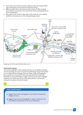
Storm drains: Storm drains have been added to reduce the impact of flood water entering the main channel from Harberton Stream. Riffles and pools: Due to the extensive work a system of riffles and pools were created to maintain the river’s natural flow whilst providing habitats for macro-invertebrates. New culvert: A new culvert to allow water to flow under the main road was installed to relieve pressure on the existing drainage network.
figure 1.41 Plan of the Harbertonford flood defence scheme.
Flood hazard mapping Food hazard mapping is used to identify areas that are susceptible to flooding when the discharge of a stream exceeds the bankfull stage. Using historical data on river stages and the discharge of previous floods, along with topographic data, maps can be constructed to show areas expected to be covered with floodwater for various discharges or stages. They can also be used to highlight properties and infrastructure at risk, which allows planners and insurance companies to produce cost benefit analysis.
now investigate 1
Suggest reasons why a hydrograph for one location will experience changes over time.
2
Suggest reasons why two hydrographs in adjacent catchments may show different characteristics for the same rainfall event.
Hydrology and fluvial geomorphology 37