A NOAA Center of Excellence for Operational Ocean and Great Lakes Mapping
The Center of Excellence has been established by NOAA with designated funding from Congress to address significant unmet needs in NOAA’s statutory and treaty-based hydrographic and ocean and Great Lakes mapping responsibilities.
“
Working in unison with and leveraging existing capabilities, including the Joint Hydrographic Center, the Center shall work across NOAA Line Offices, including NOS, OAR, and the Office of Marine and Aviation Operations (OMAO), to support and grow the Nation’s deep water, shallow water and coastal mapping capabilities and data holdings, in partnership with industry.”
(https://www.congress.gov/117/cprt/HPRT50347/CPRT-117HPRT50347.pdf)
Vision
The Center of Excellence will serve as NOAA’s unified approach to provide:
• A focal point for activities transitioning developments in mapping platforms, sensors, and concepts of operations into operations.
• A focal point for applied training for mapping and surveying operations, to grow and diversify the pool of well-qualified talent in this expanding field.
• An agency-wide capability to provide technical support for ocean mapping technologies to operators in the field on an increasingly diverse set of platforms.
• A mechanism to leverage public-private partnerships in advancing the nation’s ocean and Great Lakes mapping goals.
Goals and Benefits
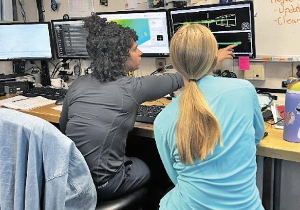
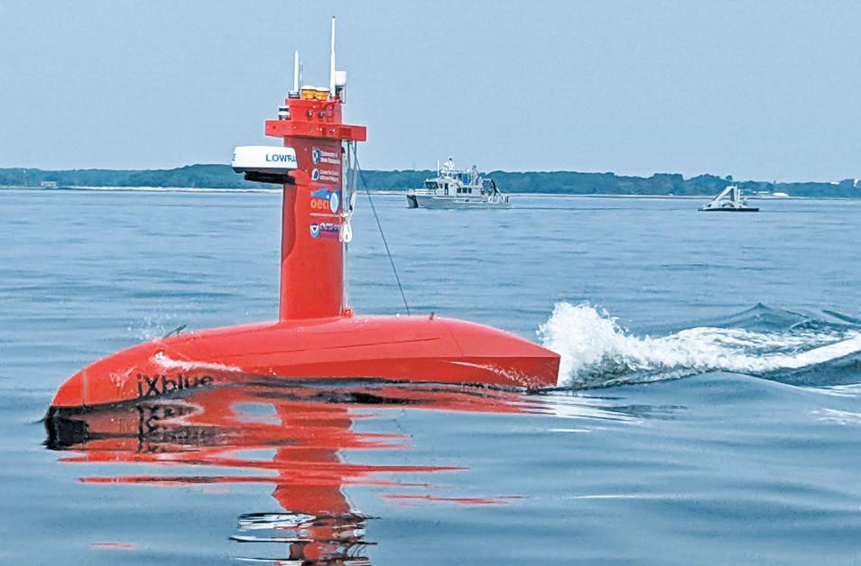
Support to Operators in the Field—The Center of Excellence will provide technical expertise and systems support for NOAA’s Ocean and Lake mapping operations on an increasingly diverse set of platforms, including new ships and uncrewed survey vessels. The CoE will serve as a bridge between NOAA’s Office of Marine and Aviation Operations (OMAO), Ocean Exploration and Research (OAR), and Coast Survey, streamlining resources and leveraging expertise to support hydrographic survey assets and serve as a liaison with private industry representatives providing training and system support for NOAA ocean and lake mapping missions. The CoE will build a cohort of technical support experts across NOAA programs, identifying what technical support the ships need and how to best provide those services to the NOAA fleet.
A fully staffed and equipped ocean/lake mapping system support program will ensure that NOAA’s diverse set of mapping-capable ships and platforms will operate effectively and produce mapping data that meet primary mission goals and can be readily shared for maximum value across other NOAA programs.
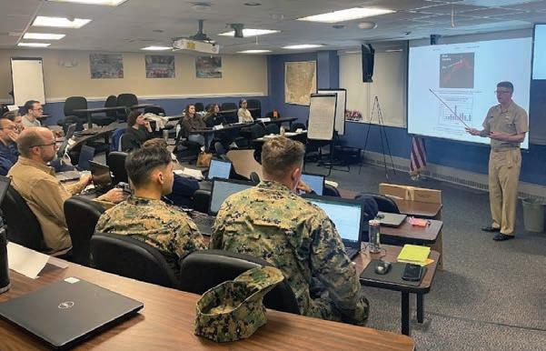
Applied Training and Growing the Pool of Talent
—The Center of Excellence will create a NOAA ocean, coastal and lake mapping competency structure to describe and build core competencies across NOAA offices and platforms, complementing the International Federation of Surveyors/ International Hydrographic Organization/International Cartographic Association hydrographic education and training standards,, and THSOA certification requirements.
Certification of competency will assure that NOAA personnel are qualified to perform and oversee the complex tasks associated with producing authoritative hydrographic surveys and ocean/lake mapping products. Access to certification programs will enhance career development opportunities for NOAA’s workforce and retain institutional knowledge.
Through the training structure, the Center of Excellence will serve as the primary resource within NOAA program offices and the external hydrographic community for the delivery of hydrographic survey and ocean/lake mapping training.
A full-time dedicated training organization and facility will provide an optimum learning environment and will foster the maintenance of a fully professional hydrographic and ocean/lake mapping workforce across NOAA line offices and in NOAA’s private sector hydrographic partners.
The training program will provide undergraduate internships and work-study programs to develop to the next generation utilizing DEIA principles as a pathway for greater and more diverse participation.
Research to Operations
—The Center of Excellence will serve as a hub to leverage the research conducted at the Joint Hydrographic Center (JHC), Center for Coastal and Ocean Mapping (CCOM), Center for Ocean Mapping and Innovative Technologies (COMIT)and elsewhere and integrate this into practical operational equipment implementation and procedures. This role will complement and extend the Office of Coast Survey’s existing hydrographic technology group who support the assessment of specific products for suitability of field implementation among NOAA hydrographic survey units.
A dedicated and staffed program for transitioning research developments into operations will result in more effective implementation of new technology on NOAA and private sector mapping platforms, minimizing the risk of failure, and reducing the loss of productivity often associated with the introduction of new systems and software.
Public Private Partnerships—The Center of Excellence will leverage public-private partnerships to support each of these primary objectives and to foster a strong relationship between NOAA hydrography and ocean/ lake mapping programs and the private sector. Through the CoE, NOAA will continue to build relationships with professional societies including THSOA, with UNH and other academic institutions, and their industry partners focusing on hydrography, and will serve as a hub for the full set of industry partners driving technological innovations.
A robust program to leverage public private partnerships will result in improved productivity, enhanced national ocean and lake mapping capabilities, and maximum value for US users of hydrographic and ocean/lake mapping data and products.
Leveraging the Joint Hydrographic Center—In meeting its technical support, training, research to operations and public private partnership goals, the Center of Excellence will leverage the substantial capabilities of the Joint Hydrographic Center in all those activities. Among other capabilities, the Joint Hydrographic Center:
• Provides ocean mapping system technical support to the national academic research fleet
• Offers internationally-recognized, graduate-level advanced education in hydrography and ocean mapping
• Operates the world’s foremost ocean mapping research Center
• Through its UNH component, maintains impressive industrial partner program that engages most of the leading private sector firms and many non-government organizations in the hydrographic and ocean/lake mapping profession
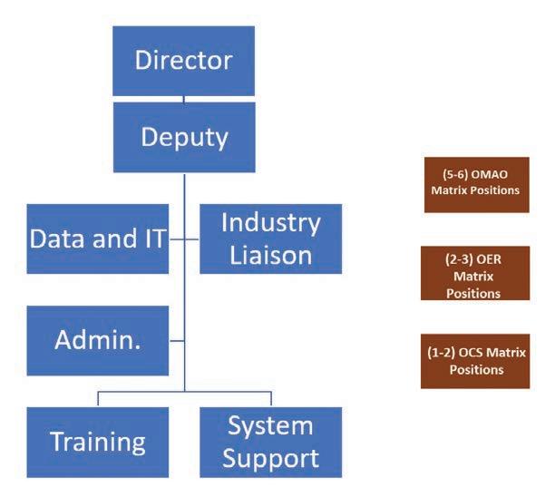
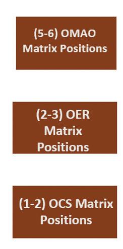
Structure and Staffing
The CoE is led by a NOAA hydrographer and staffed with a startup team based at the Joint Hydrographic Center at the University of New Hampshire, in Durham, New Hampshire. Once fully realized the CoE will be housed in new, dedicated facilities at UNH, and will accommodate approximately 20 employees consisting of a mix of federal civil service employees, NOAA Corps Officers, NOAA contract affiliates, and matrixed NOAA staff from other line offices and OCS divisions whose duties complement the mission of the CoE. Additionally, the new facility may provide office and collaboration space to other NOAA employees in ocean mapping related duties as “tenants.”
Implementation
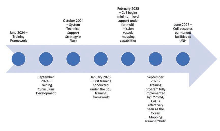
A phased approach is being used to stand up the CoE. The 1st phase, underway beginning in late FY 23 comprises minimal staffing needed to stand up the Center. The initial staff provide oversight of the FY 23-25 construction grant to the University of New Hampshire, coordination and collaboration across line offices, management of existing OCS training programs and the execution of hiring actions to adequately staff and manage all aspects of the CoE. Existing NOAA piecemeal ocean mapping training will evolve into a centralized, and standardized curriculum that will be instrumental in ensuring a well-trained and competent mapping workforce within the agency and among industry partners.
The 2nd phase of implementation is for the CoE to become the epicenter of technical expertise to support the NOAA mapping community, comprising a skilled group of experts who provide training, technical support and who can leverage research into practical operational systems and procedures. The CoE will provide technical expertise and systems support for NOAA’s mapping operations on an increasingly diverse set of platforms, including new ships and uncrewed survey vessels.
Action to Date and Milestones
In the final implementation phase, the CoE will be fully staffed and will have the physical infrastructure in place to support all mandated activities. The Ocean Mapping facility at the UNH campus will include state-of-the-art instructional spaces to carry out the newly developed career-based training program.
For system support and transition to operations, the facility will provide experts and tailored space for shipping and receiving, assembly and staging of equipment, indoor and outdoor working and storage space, and proximity and availability of vessel support to fully support testing of data acquisition systems and platforms, including UxS.
• September 2023: Award of 3-year, $20M Construction Grant to UNH for an Ocean Mapping Center of Excellence Facility on the UNH campus
• Development of priorities–guided by Congressional direction
• Development of Stakeholder Engagement Strategy-ongoing
• Transfer of ocean mapping training management and expenses to the Center of Excellence:
• 2023 Advanced Hydro Training
• 2024 Basic Hydro School
• 4 individuals in Full-time University Training
• 2 NOAA students to Shallow Water Multibeam course
• NOAA Ship Nancy Foster 2023 student research cruise (students from UNH, USF, College of Charleston)
• Development of Staffing Requirements
The CoE has ambitious and meetable milestones for full operational capability.