


CLAIRE.Q.MO ARCHITECTURE CV 2011


 Site Diagrams - Viewing spots, Public/ open plazas
Parti Models - Courts, and Projecting Frames
Final Concept Model
Revit Model fitted in Site Model
Sections - Galleries NS, EW
Site Diagrams - Viewing spots, Public/ open plazas
Parti Models - Courts, and Projecting Frames
Final Concept Model
Revit Model fitted in Site Model
Sections - Galleries NS, EW


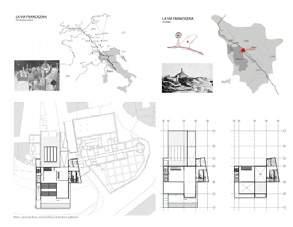
The San Miniato museum is located at a strategic site on the route of trading, La Via Francigena in Tuscany. This is at a charming town that’s overgrown with residential establishment. It’s urbanism is at the hill, the landscape of the town includes the up and down framing of the city fabric, with one icon and gathering site being the bell tower. The proposed design is inspired by the linear town layout and framing perspective to mimic the context by following an established sequence and ‘story board’ to dedicate a place of celebrating the local culture, by going through the musem program and navigate through the building to be the beginning and end of the town. Precedents of the project includes James Turrel and Richard Sierra’s framings by plane and masses.


 Approach Perspective
Elevations - Urban Facade, Hillside Facade
Approach Perspective
Elevations - Urban Facade, Hillside Facade


The Underarmour Headquarters Office Building locates in the tip of North End Boston, Mansechussets. In addition to its unusual triangular site shape, its location has many cultural and environmental challenges. It faces the brutalist government garage, half of the site is under its shadow. The narrow streets on the west brings heavily poluted air from traffic. How does this office building maximize lighting, preserve energy and contribute interests to the commercial surrounding?

The Design propose a high performance steel construction with an ‘travel’ atrium, to passively ventilate the office spaces in the building, It devides the public programs towards the south-east streetfront and private open office towards the north. Along with glazing on avtive programs, the atrium contribute to bring natural light deep into every floor. The back street facade pressures the air from street level up to the buidling via a louver system that purifies intake ventilation.


The public enters from the triangular front, and able to access the store and gallery of first four floors. The auditorium is floating away from the floor plates creating an relaxation island, with dynamic lounge/ cafe under, and an ourdoor garden above. The elevator cores are pushed at the two ends of the envelop, maximize the circulation flexibility. Behind the core at the back, there are individual private offices facing a seve floors high green wall.


Program Model
Transverse Section


The Sustainable Superstore is an invention of reconstructing what forms a traditional big box suburban strip mall. Part one of the program study is documenting the experience of traveling to a mall location from a bus station, traveling, arriving at the parking lot and go get the items, hop in & out. The proposed program each students picks a topic and I selected the vatious
food processing and preservation methods, which will be held at each various units at the periphery of the store, serving as education component as well as functioning for proper farm to table servings. The store is powered by solar panels and geothermal technologies and is self-serving for all costomers. It’s an utopian approach to a future state of store prototype without surveilance.


The Downtown Parking Lot project is based on 3-part-briefs: first, mapping an existing parking lot in downtown Syracuse, utilize the surrounding traffic pattern moniforing of 24 hours, regardless of weather, to choose an ‘action verb’ for next steps of formal exploration both digitally and physically. Through site surveying, an irregular shaged inter-street lot was chosen as it sits on the only diagonal street downtown, it presented opportunites to break the traditioanl square sites. A close verb associated with site movement is ‘interlock’; secondly, based on the verb through trials and series of digital models, with ‘continuity and interlocking spaces’ in mind, a singular module was further explored; thirdly, a 2-stories motel module were developed, where lower level is designed for communal programs such as galleries, conference rooms, classrooms, upper levels are compact living quaters.


The John Lennon Music Center sits on a fictional corner site reference a typical New York street block. At the long side of this 50ft x 100ft property there is a 12ft raise slop on the street. On the elevated back of propety it links to a semi private community garden that only has access through each building on the same street. How does this compact site address a music center that attracts the local community in its program and turns the corner of street creatively in architecture? And How to mingle the Music and a Library?
The John Lennon Music Center adapts the street block rhythem of verticality on its facade and “sheer” the circulation in its parti to feed the visiters in the main volumn of program. It’s a juxtaposition to ballance the music scene and library dedicated to John Lennon. The concert attracts public all the wall to its back on ground floor and vertically extends on the back of two more floors to serve the need of being in the music, while the library stays in front of the building occupies double stories of major space to house the collection of publication and CDs for this legend.


 Front Elevation
Side Elevation
Concert Hall Library
Outdoor Performance
Front Elevation
Side Elevation
Concert Hall Library
Outdoor Performance
The House as Site Site as House project sits on a Lake Front property with 20ft drop in elevation from the road to the water level. This is the first semester project after learned the primary architectural language from the Architecton and Painting analysis. Learning the Modern architecture through designing a vocation house for a writer. How to design a house that takes advantage of the site as well as blur the boundary between indoor and outdoors.
The Program of this project is single person vocation house. The design concept want to maximize the view towards the lake, and have clear spatial arrangement to have a sequence leading from the most public to the private, while visually emphasis the most important program which is the study for the whiter, from first approach to the site at any point on the property that’s the first piece to see. The major living quarters is linked to the private by the louvered “bridge” it links the programs, the courtyard, and pool with the lake.


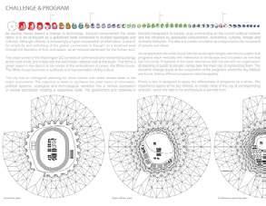
Analyze the existing site constraints and uncover the layers of movement patterns between traffic, public pedestrains, and white house employees and residents
Analyze the designed program and project 10 x larger to accomodate future expansion and associated roles currently unable to be on site due to space constraints, Indicating a public to proviate smooth transition.
Site Plan with parking
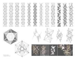
Materials studies: Tensigrity and Trusses


 Exploded Axon:
Top: Glazing
Right: PV panels on east facade
Bottom: Site structure mimic building geometry
Exploded Axon:
Top: Glazing
Right: PV panels on east facade
Bottom: Site structure mimic building geometry


Materials studies: Tensigrity morphing scales

“Yet it remains embryonic in each design of the new architecture: there is only a great, invisible space in which relations and interpretations, rather than boundaries, reign”.
By Sigfried Gierion


The London Urban Studio was tutored by two Designers from the Special Modeling Group of Foster and Partner’s office. Each team were to propose a transportation intervention that could be built with rapid-prototyping technologies. My team has surveyed various London Transportation system and decide to propose a defined, interactive Traffic Island by bring in the headlights of each car driving by to have an transient experience for pedestrians to enrich the time spent crossing streets.


The London city scape is nothing like a city grid. Through its development in history, city streets had grown into organic curves. The left over spaces of traffic island are in a significant amount. It barries between cars and pedestrians, and is the most passive space, on it, people do nothing. We propose a parametrically designed typology that using the shape of each island and the traffic surrounding to bring car light into pedestrian spaces to make away of the urban surrounding by being part of it.


 Island Overall Mock up
Concrete Tiles with Exploded Glass Cover System
Pedestrian Performance
Individual Brick with Mirror edge
Island Overall Mock up
Concrete Tiles with Exploded Glass Cover System
Pedestrian Performance
Individual Brick with Mirror edge


The Light Vessel Fabrication project started with the concept of being an individual module able to apply to multiple functionality such as filtering light and holding plants. The design is a 12”x16” curved ‘light brick’ that flips direction adjacently and upside down that forms a continuous surface. It’s made of transparent, translucent and chrome plastic with a painted pattern that visualize its curvature. By connecting two walls, it’s able to stand, and hold LED lights in between. By inserting a ‘water pocket’ that the ‘brick’ could also hold plants.


Population
Residential Density


Nan Lian Garden (2006) 3.5 Hectares | Kowloon
Hong Kong Park (1991) 8 Hectares | Hong Kong Island
Aviary: Conservatory: Sports Center: Squash Center: Children’s Playground: Clock Tower: Central Garden: Olympic Square: Vantage point: Tai Chi Garden: Conservation Center:
Badminton Basketball Netball Courts
Volleyball Courts Multi-purposes Table Tennis Tables Fitness Room
| 30m tall
Kowloon Park (1970s) 13.3 Hectares | Kowloon
Mini-Soccer Pitch: Fitness Trail:
Children’s Playground:
Discovery Playground: Maze Garden:
Sculpture Walk+ Garden:
Color Garden:
Chinese Garden:

Roof Gardens: Piazzas: Loggias:
Viewing Cone:
x1 (7-a-sided) 500m with 8 Fitness Stations
40x20m2
(capacity of 880)
Tennis Courts: Bowling Green:
(1957) Swimming Pool Complex:
Soccer Pitches:

Basketball Courts:
Fitness Station+Jogging Trail:
Children’s Playground:
Model Boat Pool:
Bandstand:
Central Lawn:
Pebble Waling Trail: Resturant:
Fast Food Kiosk:
x14 (Seating Capacity of 3607)
x2 Lawn with 12 Arti cial Turf Lanes
1x 50mx5 Lane (capacity of 1100 swimmer+1700 spectator)
x6 (7-a-sided pitches)
x4
625m long + 6 Practice Stations
x5
954m2 (0.32 m deep)
228m2 (100 Seating)
2 Hectares

Among the ranges of domestic helpers, the Philipinos have the best reputation, even, they are rated as “ The most Professional Domestic Helpers of the whole


(Continue at P25)


World”


In the Morning, the Maid isstressed as the Masters are getting ready for work, she had to prepare clothes and food with any additional accidents


Daily Chores are including Laundry, Cleaning, taking care of the pet etc


During Lunch Hours Young Masters come home for Lunch, activities stay in the living room


Early Afternoon is the most tranquile time for Maids, there are time for a short break for TV and reading books
Dinner time sometimes the Female Master will join the Maid to prepare Dinner, and after cleaning-up, it is the maid ‘s job to Tutor English to the Kids
After Everyone Else went to Bed, Maid will only have time for herself to be in her room

Advisors : Anne Munly, Clare Olsen
Author: Qiong (Claire Mo), 2011

Tensile Structure and Roof, location for lanterns during festivals

Locations for Signage, storage of equipment
Park Level with mild slope for areas created for groups sitting facing each other
Balconies for semiprivate group events
Level 2-4 circulation
Level 2 circulation level with group seating at periphery, ‘hilly zones’ for parklike activities
Site Section - Across reclaimed waterfront up the hills through mid-sections to residential districts
Singular design that can ‘travel’ from waterfront all the way up the hills is based on simple idea of a pedestrian bridge, like the roads, remains simple yet adaptable.


