
Gladesville Heritage
Trail
2nd Edition
About this book
The Gladesville Heritage Trail Book is a project of the City of Ryde with the Ryde Heritage Advisory Committee and the Ryde Heritage Working Group 2022-2024. The updating of the Heritage Trail booklets was produced with the support of Heritage NSW through the 2023-25 Community Heritage Grant (23-25CH068) –Our City of Ryde: Interactive Heritage Walking Trails. We acknowledge and appreciate the funding provided, which has contributed to the promotion and preservation of our local heritage. We hope to produce additional booklets in the future and would appreciate feedback from readers. Please contact: cityofryde@ryde.nsw.gov.au

Language Assistance
We are committed to providing accessible services to people within our community and customers from culturally and linguistically diverse backgrounds. If you have difficulty understanding this book, please call the Translating and Interpreting Service on 131 450.
Gladesville Heritage Trail Online
Interactive Map
To view the online interactive map visit www.ryde.nsw.gov.au/ GladesvilleHeritageTrail or scan the QR code

Acknowledgement of Country
The City of Ryde would like to acknowledge the Traditional Custodians of this land, the Wattamattagal (or Wallumedegal) clan of the Darug nation.
The City of Ryde would also like to pay respect to Elders both past, present and emerging, and extend that respect to other Aboriginal and Torres Strait Islander people.

2025.
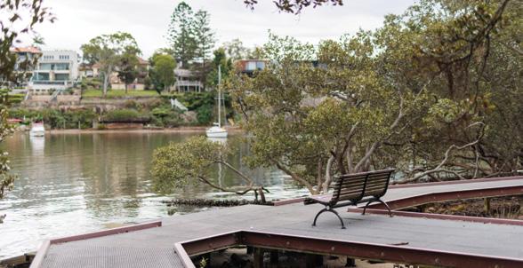
Looking Glass Bay,
Preface
This booklet, produced by the City of Ryde as a guide to discovering and rediscovering our local history, covers heritage sites west and south of Victoria Road in the village of Gladesville. This is a 2025 edition of the booklet. The sites can be visited in any order and a complete loop is just over 5km. Access is on formed paths but as there are a number of steps and steep gradients, not all of the route is suitable for a wheelchair or pram. Buses run frequently along Victoria Road, free car parking is available under Gladesville Shopping Village (2 hours), in Jordan Street (2 hours) and at Banjo Paterson Park (unlimited). Public toilets are located on the corner of Jordan Street and Victoria Road, in the Shopping Village, and in Banjo Paterson Park. Some of the places along the walking trail are not listed items of heritage significance, however, they been included for their historical, architectural, social or aesthetic importance to the locality. A few sites are within the Municipality of Hunters Hill.
When viewing sites, please respect private property. Be aware that churches are not always open, and that entry to school grounds is prohibited other than to authorised visitors.
Much of the information in this booklet has been summarised and updated from Council’s database of heritage listed sites available through the Department of Climate change, Energy, the Environment and Water: www.hms.heritage.nsw.gov.au/App/ Item/SearchHeritageItems
For additional information see the following:
• Blaxell G. 2009. The River: Sydney Cove to Parramatta. Halstead Press.
• Emery L. 2011. Pictorial History. Hunters Hill. Kingsclear Books
• Geeves P. 1970. A Place of Pioneers. The centenary history of the Municipality of Ryde. Ryde Municipal Council.
• Levy M.C.I. 1947. Wallumetta. A history of Ryde and its districts 1792-1945. W.E. Smith, Sydney.
• Martin M. 1 998. A pictorial History of Ryde. Kingsclear Books.
• McAndrew A. 2004. Glimpses of Gladesville Past and Present.
• Ryde District Historical Society 2015. Ryde Goes to War 1914-1918. RDHS.
• Shaw K. (Ed.) 2002. Historic Ryde. A guide to some significant heritage sites in the City of Ryde. Ryde District Historical Society.
• Smith K.V. 2005. Wallumedegal: An Aboriginal History of Ryde. Sydney, City of Ryde Council.
Photo source: Ryde District Historical Society.
About Gladesville
At the time of European settlement this area was occupied by the Wallumudegal who had lived along the river for about eight thousand years since sea level reached its present height after the last Ice Age.
Traces of these original inhabitants may be seen in middens, rock shelters and rock engravings.
Shortly after the First Fleet arrived a smallpox epidemic ravaged all nearby Aboriginal groups and, consequently, we know very little about their numbers and lifestyle. The best known local Aboriginal person was Woollarawarre Bennelong who was a Wangal man from the south side of the river. Bennelong later became the leader of a composite group of survivors known as the Kissing Point Tribe in the first decade of the 19th Century.
In 1824 the visiting French surgeon and pharmacist Rene Primavere Lesson wrote: ‘the tribes today are reduced to fragments scattered all around Port Jackson, on the land where their ancestors lived and which they do not wish to leave.’
European settlement began with land grants in 1792 on the ‘Eastern Farms’ and from 1795 in the Gladesville and Tennyson Point areas. A noted convict artist John Doody, received a grant in 1795 as a reward for his paintings of Norfolk Island plants however, he never lived there and it was reallocated to Ann Benson in 1796. Another convict settler, John Glade used that land as an extension of his 1802 grant and purchased it in 1817. The district slowly became a rural farming and dairy area supplying the Sydney market, but it was isolated, with the only access being along the Parramatta River.
Isolation was reduced when the Great North Road opened in 1832. Planned by Major Thomas Mitchell in 1825 it first carried traffic when the punt crossed the river between Abbotsford and Bedlam Point. The road (now Victoria Road) ran along the ridge to Ryde and eventually to the Hunter Valley and Newcastle.


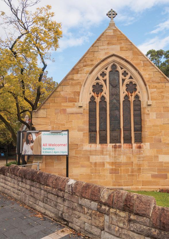
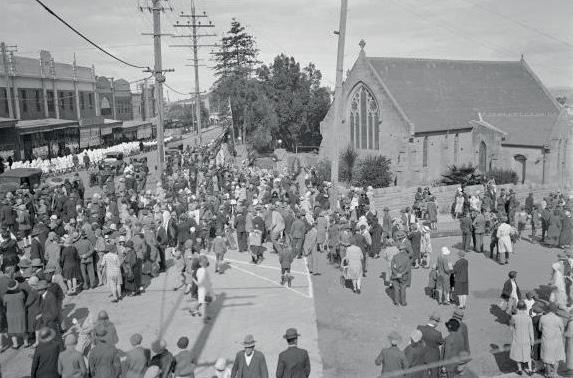
Anglican Christ Church, 2025.
The first attempt at urban subdivision was made in 1841 when Thomas Stubbs tried to sell Battersea in small lots west of the Great North Road to the edge of Doody’s grant. The 1840s was a bad time for land speculation as the colony was almost bankrupt and the subdivision failed. John Glade died in 1848 and his expanded property along with Battersea was obtained by a Sydney solicitor and developer William Billyard, who offered it for sale from November 1855, as the Glades Ville Estate. This development included a wharf to enable better access and to overcome the difficult task for passengers of alighting in midstream from the regular Parramatta River steamers onto the Bedlam Punt to be conveyed to shore. Sales continued slowly over thirty years but it was this subdivision which defined the present roads and many property boundaries. Subdivision of other large estates continued into the 1920s.
The first hotel in Gladesville was The Flagstaff Inn, licensed to John Worthington in 1856. Several wharves and ferry services were established. From 1861 residents were petitioning for improved road access to Sydney which was obtained after 1874 when land was released from the Field of Mars Common and funds became available to construct bridges at Gladesville (1881, replaced by the present concrete-arch bridge in 1964), and Iron Cove (1882).
The small settlements at Bedlam Point (Tarban Creek) and Flagstaff Hill became the village of Gladesville by the 1870s. The post office moved from Wharf Road to the crest of the hill near the Flagstaff in 1867. Sydney’s first Protestant Hall was built in the same year, the Anglican Church opened in 1877, and Gladesville Public School began classes in 1879.
Map and Key
Map and Key

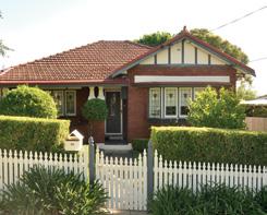
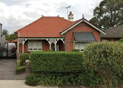
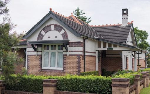
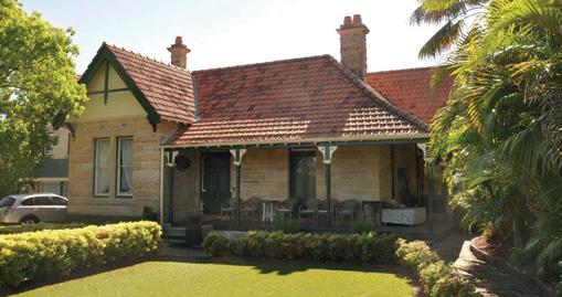
St Andrews Presbyterian Church 1
LOCATION 265A Victoria Road, Gladesville
STYLE LATE Sandstone Victorian Rustic Gothic
YEAR 1886-1887
ARCHITECT Mr. John Symonds
BUILDERS J.W Park and J.J. Dakin
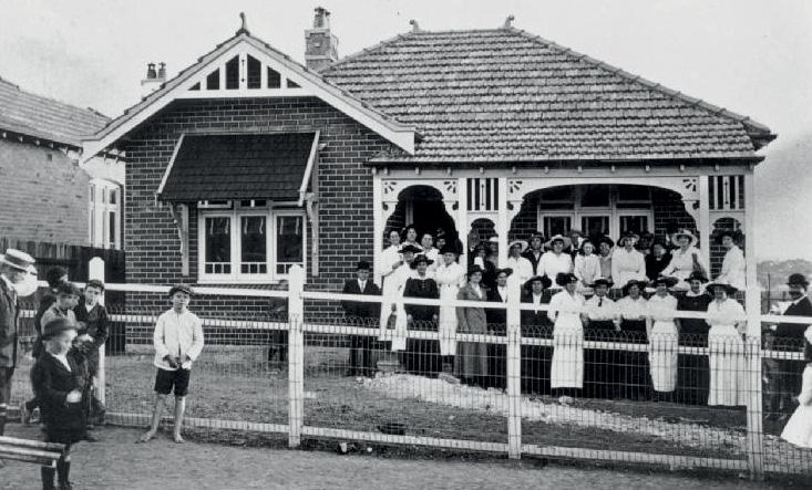
St Andrews Presbyterian Church was the first Presbyterian Church in the district. Planning began in 1886 and until 1887 Presbyterian meetings were conducted in Euroma, a cottage on Wharf Road (Item 18a). The first sermon was delivered in 1887 in the shared Protestant Hall on the Christ Church site (Item 5). In 1887 part of
Harriet Miller’s Sunnyside property was donated for the church. The remainder of Sunnyside was later purchased and used as the manse until the 1930s.
The building cost £2,768 and seated 270 people. It officially opened in July 1889. Throughout the years, various works were undertaken such as the addition of a classroom in 1917 which James Wallace Park and his wife Catherine donated in memory of their son Wallace, killed at Lone Pine on the Gallipoli Peninsula (Item 7e). In 1931 the porch and stone wall were relocated when Victoria Road was widened.
An honour roll of WWI church members, including the Elliot brothers (Item 7b), may be seen on the south façade. The red brick War Memorial Hall in Pittwater Road was opened in February 1955.
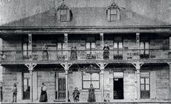
View of St Andrews Presbyterian Church c1930 prior to the widening of Victoria Road and the removal of the front entrance porch. Photo source: Ryde Library.

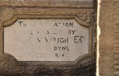
The foundation stone which was laid in 1888. William Wright was a merchant and Island trader who opened a shipping agency in Auckland in 1843, built an impressive house on the Drummoyne Estate, and was a benefactor of several churches, including Balmain, Hunters Hill and Gladesville.
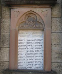
St Andrews Presbyterian Church –WWI Honour Roll on the southern façade. Photo source: Ryde Library.
St Andrews Presbyterian Church, 2025.

2 Gladesville Shops
Victoria Road (Great North Road) forms part of the boundary between Ryde and Hunters Hill Councils. Buildings in the street are typical of retail development from the late 19th Century to the present day but cafes, restaurants, lawyers, and health care services have replaced butchers, green grocers, pharmacists, mercers (dealer in textiles) and hardware stores. Today, commercial strip development is challenged by supermarkets and the need for car parking.
After the Gladesville Bridge was opened in 1881, Victoria Road became an important route connecting Ryde to the city and was serviced by horse-drawn buses and then electric
trams between 1908 and 1949. The journey from Circular Quay to Top Ryde was part of the longest tram route in Sydney and took one hour to complete. Many of the earlier buildings were demolished and redeveloped in the 1930s as part of the widening of Victoria Road.

View of Victoria Road and Gladesville shops c1930. Photo source: Ryde Library.
Victoria Road and Gladesville shops, 2025.

2a. Wilsons Corner
LOCATION 263 Victoria Road, Gladesville
STYLE Federation Free Style
YEAR c.1900

Wilsons Corner building, 2025.
One of the oldest remaining commercial buildings is on the corner of Pittwater and Victoria Roads and is easily recognised as a former butcher shop by the bullock’s head on the parapet. The building is defined by its red brick walls with horizontal rendered white bands.
This shop was first operated by Bob Woolley then taken over by Jack Wilson in 1924. Jack was followed by his son Ray, and grandson Trevor until the retail business closed in 1988. The family also had a ham and bacon factory in Boronia Park that continued for another four years.
Wilson’s Corner building 1916. Photo source: Ryde District Historical Society.
2b. Former Commonwealth Bank of Australia
LOCATION 219 Victoria Road, Gladesville
STYLE Inter-War Art Deco
YEAR 1920, 1937
ARCHITECTS Ross and Rowe (1920)
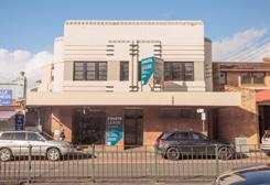
This is the only true art deco building in Gladesville and is similar to many other Commonwealth Bank buildings of the same age.
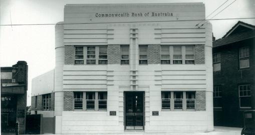
The bank was formerly a branch of the Government Savings Bank built by Alexander Simpson and Sons under the architects Ross and Rowe in 1920. The Government Savings Bank merged with the Commonwealth Bank in 1931 and in 1937 the building was refurbished with a new façade constructed by Hogden Brothers.
An awning and a new street face were added in 1992 so today only the upper level reflects the art deco detailing. It is best viewed from Trim Place (Item 3). This branch of the bank closed in 2023 and the future of the building is unknown.
Former Commonwealth Bank of Australia, 2025.
The Commonwealth Bank of Australia in 1937. Photo source: Ryde Library.
2c. Gladesville Hotel / Betars’ Building
LOCATION 177-181 Victoria Road, Gladesville
STYLE Inter-War Federation Free Style and Victorian Filigree
YEAR c.1885 and c.1910-1920
Betars’ Building was constructed between 1910 and 1920 by Frederick and Nicholas Betar. It is a typical example of shop-top housing from the early 20th Century and has interesting architectural detailing including the circular tower on the corner. In 1932 the building contained a music shop, a mercer, a cake shop, and a hairdresser. The former Gladesville Hotel is located on the corner of Junction Street and Victoria Road and is the earliest of the extant hotels in the Hunters Hill/Ryde area. The building was constructed in stages between 1856 and the 1870s and originally had a frontage to Junction Street. In 1889 the proprietor was J. Eyles who advertised ‘First-class accommodation to scullers’ along with the facility of a boatshed. Professional sculling on the river was very popular at that time. The hotel ceased to operate in 1918 but, surprisingly, the building is still intact although the façade is hidden behind retail shops at the base of Betars’ Buildings. Evidence of the original sandstone wall is visible internally. The hotel building may incorporate parts of the earlier establishment, The Flagstaff Inn. Today that name seems odd but there is also a Flagstaff Street


and a Flagstaff Car Park off Cowell Street. All derive their names from the fact that there was a flagstaff relay station (telegraph) on the crest of the hill from about 1826 that was used to relay government messages between Sydney and Parramatta.
Betars’ Building, 2025.
Gladesville Hotel in 1878, still present but hidden behind Betars’ Building. Photo source: Ryde Library.
Gladesville Hotel, undated. Photo source: Ryde District Historical Society.

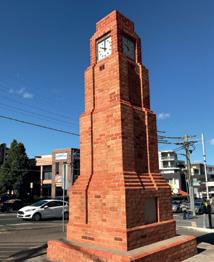
2d.
Sheridan Memorial Clock
LOCATION At the intersection of Wharf Road and Meriton Street, Gladesville
STYLE Inter-War Functionalist
YEAR 1941
ARCHITECTS J.C. Sutherland
This clock tower is a landmark on Victoria Road. Originally planned as a traffic separation structure designed by Ryde Council Engineer J.C. Sutherland, it was constructed in 1941.
In October of that year, popular Ryde Alderman James York Sheridan of 36 Tyrell St., Gladesville (Item 7) died at the age of 53 and Council decided to dedicate the memorial to him. A red granite plaque on the base of the tower pays testament to Alderman Sheridan. Some restoration was done on the tower in 1969 and 2017 damaged bricks were replaced. The top of the tower was reinstated according to the original plan. The Sheridan family were guests at a rededication ceremony chaired by the Mayor of Ryde
The age of the white building behind the clock tower in the 1990 photo is not known but in 1903 it was purchased by Joseph Kramer and called Kramer Hall. From 1913 in the era of silent films it was the first movie theatre in Gladesville operated by Gus Bowe, a Drummoyne grocer who became the ‘picture show man’ in Ryde. It later had a chequered history being used as a boat factory, roller skating rink, wartime camouflage net factory, and a production facility for Festival Records. In the 1990s it was a Fashion Warehouse known as the Green Door. The building was demolished in 2015.
The origin of the name of Meriton Street is not known, however, the street was the inspiration for the naming of Harry Oscar Triguboff’s business Meriton, the largest property developer in Australia. In 1968 Triguboff built his second block of units Elizabeth Court, at 20 Meriton Street. The company has since built more than 77,000 units in Australia.
View of the Sheridan Memorial Clock facing towards Wharf Road and Meriton Street c1990. Photo source: Ryde Library.


The Sheridan Memorial Clock. Photo source: Ryde Library.
The clockface of the Sheridan Memorial Clock, prior to restoration.
Sheridan Memorial Clock, 2025.

Bayview Hotel


LOCATION 166-170 Victoria Road, Gladesville
STYLE Inter-War Free Classical style YEAR 1879, 1928-1934 (additions)
The original Bayview Hotel was the third hotel in Gladesville and was constructed in 1879 on land granted to John Doody. The present building replaced the much altered original between 1928 and 1934 when this part of Victoria Road was widened. It is a two storey Inter-War Free Classical Style hotel which adjoins a two storey shop to the east and a plaza (Trim Place Item 3) to the west. Built to the new road alignment, the hotel displays a high degree of symmetry through its central balcony with arched openings and parapet walls on either side.
The Bayview Hotel, 2025.
The Bayview Hotel in 2012.
Photo source: Ryde Library.
The original Bay View Hotel in 1906. Photo source: Ryde Library. 2e.
3 Gladesville Public School

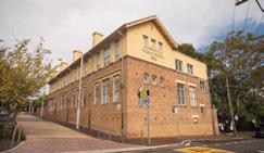
5075092 Ryde Library.
LOCATION Victoria Road, Gladesville
STYLE 1879 teacher’s residence Victorian Georgian. c1920 and c1927 school buildings utilitarian Inter-War period with some Inter-War Georgian revival features
YEAR 1879, 1920 and 1927
ARCHITECTS Government Architect
G. Allan Mansfield (1879 building), Education Department (1927)
Gladesville Public School was the first school in the emerging village and the site retains evidence of its sequential development. The original teacher’s residence and the 1920 and 1927 school buildings are all significant and reflect the growth of education facilities over more than 146 years.
When the school opened there were 56 pupils taught by Mr Bayliss. By late 1895 the enrolment at the school was 180 despite the school facilities only accommodating up to 100 students.
By May 1917 population growth was posing such problems that a new building was necessary. Constructed on the corner of Coulter and Linsley Street at a cost of £13,560, it was occupied in July 1920.
As the new building reduced the playground area, six parcels of land were acquired for school use, including a portion of Orr Street which was closed to public access. Some houses on the acquired land were retained and rented out by the school.
In 1927 another new school building was constructed at the end of Orr Street, at a cost of £34,000.
In January 1944 Gladesville Public School became a central school, catering for pupils up to 14 years of age. It reverted to a primary school in January 1956, after the opening of the Meadowbank Junior Technical High School. In 1963 amalgamation of the separate girls’ and boys’ departments started and by 1966 the school had become co-educational.
Gladesville Public School building, 2025.
Gladesville Public School, 1904. Photo reference:
3a. Trim Place
The school originally had a frontage to Victoria Road but after road widening a remnant section became a small public park, now Trim Place, with a magnificent camphor laurel that was already a mature tree in 1943. During WWII air raid trenches were excavated beneath this tree.
Trim Place is named after James (Jim) Trim, a popular teacher who taught at the school from 1915 to 1959. Within the park is a Seiko civic clock on a tall stand. Beneath it is a time capsule, buried in 1986 and to be opened in 2036.

Trim Place showing the Seiko Clock and location of buried time capsule at the base of the clock.
4

Jordan Hall
LOCATION 6-8 Western Crescent, Gladesville
STYLE Inter-War Free Classical
YEAR 1938, redeveloped 2023/25


2025.
Jordan Hall replaced the nearby 1867 Protestant Hall and was opened in 1938 as a popular place for entertainment with light-music and ballroom dancing. There may also have been a baby health centre there for some time. It was a good example of a community hall of the period with embellished architectural features, most evident in the Art Deco detailing of the parapet and the dual-tone brickwork.
The interior of the main hall was simply decorated with exposed painted brick walls and steel roof trusses. The building was used as the centre for RSL Youth Club activities for many decades and it neatly terminated the view down Jordan Street. Gladesville RSL is developing the site for residential apartments with the façade of Jordan Hall being retained.
Jordan Hall,
Art Deco influenced detailing to the parapet wall.
Jordan Hall c1938. Photo source: Ryde Library.
5 Anglican Christ Church and Rectory
LOCATION 220 Victoria Road, Ryde
STYLE Victorian Rustic Gothic
YEAR 1878, 1885, 1910, 1962
ARCHITECTS Albert Bond (1877) Cyril and Arthur Blackett, sons of Edmund Blackett (1885)
BUILDERS Peter Hall and Mr Albury (1877), John Morrison (1881-1885)
The Rectory, 2025.

Anglican Christ Church, 2025.
Anglican services began in Gladesville in the 1867 Protestant Hall, erected by the Royal Orange Lodge but shared by several denominations. This hall was purchased by Christ Church in 1935, demolished during road widening and its function replaced by Jordan Hall (Item 4). In 1988 a new hall, now used as a pre-school, was built on the original footprint.
In 1877 land for Christ Church was purchased from Mrs Coulter. Peter Hall was engaged as the stonemason and Mr Albury as the carpenter at a cost of £1,742. The eastern leadlight window is by Lyon and Cottier and was installed in 1885, other leadlight windows were designed by Falconer & Ashwin, a Sydney firm who are strongly represented in NSW churches. The first service was held on 17 November 1878 by the Dean of Sydney, the Very Reverend William Macquarie Cowper. Archdeacon King was appointed rector and was succeeded by Reverend William Lumsdaine in 1881. Lumsdaine resided in Ellora in Wharf Road (Item 14a).
The original church building forms the chancel of the existing building and was extended in 1885/6 by J. Morrison of Burwood at a cost of £3,400. Further extensions occurred in 1962. The three stages can be clearly seen inside the building by looking at the differing wood and decorations on the ceiling. In 1911 the rectory in Jordan Street was completed by Mr Pouley at a cost of £4,140.

Anglican Christ Church, 2025.
Anglican Christ Church, Gladesville, 1930. Photo source: National Library of Australia.

6 War Memorial Gates
LOCATION 220 Victoria Road,
Gladesville
STYLE Inter-War Gothic Revival
YEAR 1926
Constructed in 1926, the War Memorial Gates are dedicated to members of the Christ Church congregation who served in WWI. The gates were first erected at the corner of Victoria Road and Jordan Street but were moved after the widening of Victoria Road after 1931. They feature four sandstone pillars, ornate wrought iron double gates and six bronze memorial plaques. The gates are a testament to the local impacts of WWI on part of the Gladesville community and have played an important role during annual Anzac day services.
The War Memorial Gates, 2025.

Christ Church Memorial Gates in their original position in 1926.
Photo source: Australian War Memorial Permalink: http://cas.awm.gov.au/item/H17951item/H17951

Memorial service at Christ Church, Gladesville, 26th April 1926: Crowd gathered to witness the unveiling of the memorial gates by the Governor-General
in the
Baron Stonehaven. The tall building
background across Jordan Street is the Palace Theatre de Luxe. Photo source: Ryde Library.
7 Tyrell Street Character Area
– BOTH SIDES
Tyrell Street was declared a ‘Character Area’ by Council in 2006 because the streetscape demonstrates the traditional preference of Australians for single family houses, providing a diverse range of house styles and sizes predominantly single storey dwellings. Two properties have been listed as of local heritage significance and other properties exhibit particular characteristics or have a special history as described below.
The area around Tyrell Street was part of 60 acres granted to Mrs Hannah Mary Thompson (nee Russell) by Governor Bourke in 1835. Hannah (1801-1881), a free settler arriving on the Northampton in 1815, married convict Thomas Thompson in 1828. The couple had 13 children.
The land changed in ownership multiple times and in 1877, the title passed to Edward Harte Acres (1829-1892), a grazier of Baulkham Hills. Acres subdivided the land as
Gladesville Park in 1886. Tyrell Street was named after William Tyrell (Tyrrell) a First Fleet convict who arrived on the Alexander and was granted land nearby in 1792. Tyrell served seven years for the theft of lead from a Crown building in England. In 1810 his house and barn were struck by lightning and burned down. His partner Ann Sandell was paralysed by the strike. In later years, he worked as a carpenter and a labourer.
The subdivision was first auctioned by Hardie and Gorman on 31 July 1886 but there was little interest, and it was subsequently offered for sale again in 1896 and 1899.
Gladesville was by then well established as a village centre and had road access to Sydney via the Gladesville and Iron Cove Bridges. However, the development of land was slow with building works in Tyrell Street not commencing until the arrival of the tram service along Victoria Road in 1910.
By 1909 there was one house in the street, increasing to 13 by 1915, and 27 by 1924. No street numbers were used until 1929 and 19 of the houses were named. The last block was not built on until the 1980s when land, formerly used as a plant nursery by Truscott’s, a Gladesville florist, was sold. Subsequently, several original weatherboard houses have been replaced by modern structures.
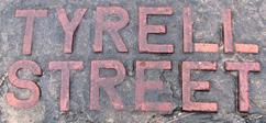
The street name is displayed within the pavement.
Photo source: Ryde Library.

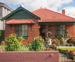
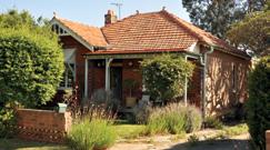
7a. 3 Tyrell Street
LOCATION 3 Tyrell Street, Gladesville
STYLE Federation Queen Anne
YEAR c.1910-1915
The first owner of the house was John Holcombe (Halcombe), a plasterer from Balmain who apparently moved in after his marriage to Vera May Pride in 1916. The house still carries an embossed copper name plate, Corelli, and it remained in Holcombe family ownership until 1981. The façade has a
circular leadlight feature window. The origin of the name is not known. One may ask if it was named after the Italian composer and violinist Arcangelo Corelli (1653-1713). If so, what was the connection?
This house is associated with politician Rodney Mark Cavalier, elected to the State seat of Fuller (later redrawn as Gladesville), representing the Labor Party in 1978. He was Minister for Education from 1984 to 1988 in the Wran and Unsworth governments and resided here for a few years.
3 Tyrell Street.
7b. 19 Tyrell Street
LOCATION 19 Tyrell Street, Gladesville
STYLE Federation
YEAR c.1912
Sometimes our heritage is lost when we look only at what is presently on the site.
Sometimes our heritage only survives in the archives.
A simple weatherboard home, Tyrone on this block was one of the earliest constructed in the street and occupied from 1912 by John and Lucy Elliot and their three boys: twins Jack James and Sidney Johnson, and younger brother Lance William. All three sons enlisted in WWI in 1916 and 1917. They served in Egypt and France. Sid was wounded twice and the others contracted malaria but all returned safely to Gladesville. No trace of this house remains but the boys’ service is remembered.

Elliot brothers welcome home to No 19 Tyrell Street in 1919. Photo source: Ryde Library.
7c. 42 Tyrell Street
LOCATION 42 Tyrell Street, Gladesville
STYLE Federation Weatherboard cottage
YEAR 1918
A modest single storey weatherboard house dating from 1918. The house is set on a sloping landscaped allotment, bounded at the street by a low masonry wall that was originally the foundation for a fence, possibly of woven wire. The house retains an intact form and displays architectural features that are typical of an early 20th Century cottage. A striking feature is the front verandah which is integrated into the main roof form covered with terracotta shingles.
Lot 25E (part of which is now occupied by this house) and six other lots were purchased by Charles Miekleham in 1901. In 1918 the Public Trustee sold Lot 25E to Augusta Ellacott the wife of Frederick William Ellacott who was a foreman carpenter and probably the builder of the house. Sands Directory lists William Ellacott as the occupant in 1920 and 1924. At that time the house was named Devon.
The original allotment had frontage to both Tyrell St and Western Crescent. The Western Crescent side was an orchard. In 1948 this was subdivided and two fibro-cement cottages were constructed in Western Crescent (one since replaced). Between 1926 and 1949 the property was owned by members of the Peel family who operated a dairy farm from Tennyson Road and across Peel Park from the 1920s to 1950 when John F. Peel sold his land to Ryde Council for a Council housing scheme.
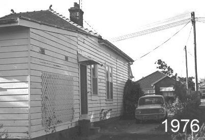


42 Tyrell Street, 2025.
Terracotta shingle tiles roof cladding.
42 Tyrell Street, 1976. Photo source: Ryde Library.
42 Tyrell Street, 1984. Photo source: Ryde Library.
7d.
40 Tyrell Street
40 Tyrell Street, Gladesville.
LOCATION 40 Tyrell Street, Gladesville
STYLE Inter-War Californian Bungalow
YEAR c.1924
This house originally named Salamis, was first occupied by Hector Bates and family. It is of solid brick construction with an attractive façade that is characteristic of the early Inter-War period Californian Bungalow style.
7e.
36 Tyrell Street
LOCATION 36 Tyrell Street, Gladesville
STYLE Inter-War Californian Brick Bungalow
YEAR c.1920
The property Cleetha was originally occupied by the Sheridan family (Item 2d).
36 Tyrell Street, Gladesville.
Newly finished house at 22 Tyrell Street on the handover day in August 1917. Note the woven wire fence which was then common. Members of the Gladesville Volunteer Workers Association are proudly standing on the front porch and pathway.
source: Ryde Library.
LOCATION 22 Tyrell Street, Gladesville
STYLE Late Federation / Californian Brick Bungalow
YEAR 1916
During WWI the Voluntary Workers’ Association was established in several states. In NSW they were organised under the Voluntary Workers (Soldiers’ Holdings) Act 1917, with the objective: ‘To provide homes for disabled soldiers or for soldiers’ widows or dependants.’ Groups were organised within local government areas, Crown Grants were available and the houses were financed by donations of land, goods, money and labour.
This house, one of more than 100 built by this organisation in Sydney, was completed for the widow (Ida May) and family (two children) of Private Albert Besanvalle, 4th Battalion Infantry who was killed at Lone Pine between 6 and 9 August 1915. Albert was buried in a mass grave of about 250 men that he may share with Wallace Park who was killed in the same action. Wallace was the son of Gladesville stonemason James Park and his wife Catherine. This link is expressed in the name of the house in mirrored glass on the front door.
Photo
7f. 22 Tyrell Street WALLACE PARK
22 Tyrell Street
From The Cumberland Argus and Fruitgrowers Advocate Saturday 28 October 1916.
‘The Gladesville Voluntary Aid Association have arranged to build a brick house with a stone foundation, on an allotment in Tyrell Street, Gladesville, and present it free of cost to Mrs. Besanville [sic], a soldier’s widow. The building and fencing are estimated, to cost £450, a good proportion of which is already in hand. On Saturday about 60 men were helping, and the fencing and the foundations were completed. Carpenters have completed the making of the door and window frames, and the brickwork has since, been started.’
Very few Voluntary Workers houses remain intact in Sydney although one other, which is a mirror image of this property remains in Earl Street, Hunters Hill.
Ida remarried in 1926 and lived in the house until moving to a son’s home in Putney in her 70s and then to another son and family on Flinders Island where she died in 1967.
18Tyrell Street, 2025.
LOCATION 18 Tyrell Street, Gladesville
STYLE Late Federation / Californian
brick bungalow
YEAR c.1910
The home of the parents of Ida May Besanville nee Nicholls (Item 7e).
22 Tyrell Street.
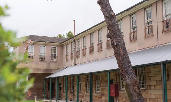
8 Gladesville Hospital
(TARBAN CREEK LUNATIC ASYLUM)
Gladesville Hospital, 2025.
LOCATION Victoria Road, Gladesville
STYLE Various
YEAR 1837
This is the oldest purpose-built asylum in Australia. The first building was erected in 1837, and the complex continued to grow until the 1970s when there was a steep decline in the number of patients. It officially closed in 1997 when inpatients were moved to Macquarie Hospital at North Ryde. Buildings were designed by many noted Government architects including Mortimer Lewis, Edmund Blacket, James Barnet and Walter Liberty Vernon. The landscaped grounds are surrounded by extensive stone walls, most constructed by Irish stonemasons from Hunters Hill. Today the 25-hectare site is owned by the NSW Department of Health and most
buildings are occupied by health service agencies and other services.
A former gate house on Victoria Road houses the museum of the Society for Preservation of the Artefacts of Surgery & Medicine (SPASM).
The gate house adjacent to the Police Station in Punt Road was built in 1874.
The Gladesville Mental Hospital site is of considerable historical importance and tours are organised by the Friends of Gladesville Hospital.

Gladesville Hospital, 2025.

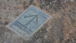
9 Great North Road
Looking toward the river on Great North Road circa 1935-1940, Rockend on the right. Photo reference: 5678498 Ryde Library.
LOCATION Punt Road, Gladesville

Punt Road is a small part of the original Great North Road, a 240km convict-built road of national significance constructed between 1826 and 1836 to link Sydney to the Hunter Valley and Newcastle.
Surveyor General Major Thomas Mitchell ordered surveyor Henage French to identify a line of road from Bedlam Point to Ryde in 1828 but crossing the Parramatta River was not achieved until a punt was installed in 1832.
From the Bedlam Point Wharf (Item 12) the road climbed up the hill to the Government Flagstaff and continued north-west, running along the line of today’s Victoria Road to St Annes Church, Ryde. Beyond the church the road turned north to travel through Eastwood and on to Pennant Hills and another road followed the line of present-day Victoria Road to Parramatta.
Great North Road trail marker.
Punt Road, 2025.
10 Rockend
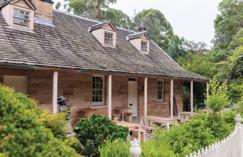
2025.
The land on which Rockend sits was purchased by John Terry Hughes in 1836 but was repossessed by the Bank of Australia in 1843 when Hughes went bankrupt during the 1840s depression. From 1850, the land passed through various owners and was eventually subdivided by Sydney Solicitor W.W. Billyard. Lot 47 was sold to builder John Crotty in March 1857 and he built the cottage.
The design with two doors onto the front verandah, and its proximity to the Great North Road, suggests it was originally built as an inn, a recommendation that had been made by Thomas Mitchell in 1830 but apparently not followed. After Crotty’s death in 1859, the property was offered for sale, being described as ‘a substantial stone-built family residence, containing seven rooms and kitchen’.
Emily Mary Barton (1817-1909) purchased the property in August 1866 and renamed it Rockend. Her grandson the poet and author, Andrew Barton (Banjo) Paterson, lived with her
LOCATION 40 Punt Road, Ryde
STYLE Victorian Georgian
YEAR c.1860s
BUILDER John Crotty

Rockend about 1910.
Photo source: Ryde Library.
for a number of years whilst attending Sydney Grammar School. In 1869 and 1891, she purchased four adjoining lots.
In 1922 the five-acres of land, including Rockend was purchased by Harold Meggitt for the construction of a linseed oil mill. The cottage was used as offices and substantially modified. The mill operated in what is now Banjo Paterson Park (Item 11) until 1974 when business closed. High-rise development was proposed but the land was acquired by the State and passed to Ryde Council for open space in 1978. The restored cottage was leased in 1986 and used as a restaurant.

Rockend about 1980 prior to restoration. Photo source: Ryde Library.
Rockend,

11 Banjo Paterson Park
LOCATION Punt Road, Gladesville

Guests at the official opening of Harold Meggitt’s linseed oil mill, Punt Road
Gladesville in November 1923 Foster, Arthur Ernest, c.1879-1958, photographer.

In 1922 this land was held by Harold Meggitt (1881-1949) who operated a vegetable oil extraction plant (Halmeg), producing linseed oil for industrial uses (mainly paint), oil cake for cattle fodder, later safflower, sunflower and canola oil for the edible oil industry. Harold Meggitt was a pioneer employer in establishing a profit-sharing scheme with his employees. When the factory closed in 1974 the site was proposed for construction of 174 townhouses.
Agitation from the local community encouraged the State Government and Ryde Municipal Council to acquire the land and create a waterfront park in 1978. The factory was demolished but the company office was retained and later restored (Item 10).

Halmeg Ltd linseed oil mill, Punt Road Gladesville around 1945. Photo source: Ryde Library.
Harold Meggitt’s linseed oil mill.
Photo source: Ryde Library.
Banjo Paterson Park, 2023.

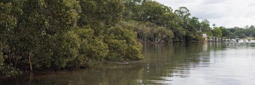
Banjo Paterson Park, with views to Looking Glass Bay and the Parramatta River, is an attractive riverside parkland retaining some of the natural shoreline which is an uncommon feature along the river. The concrete base of the site is in the shape of an Aboriginal rock engraving of a whale and the plaque is mounted on bricks from Vernals Farm in Hampshire, once the home of Governor Phillip.
In the garden beds on the north side of Rockend a flagpole marks one of Ryde’s lesser-known memorials.
Engraved on a sandstone outcrop under a large fig tree just past the end of Punt Road are the initials, A. K., and the words, DE MORTIOUS (sic) NIL NISI BONUM which translate as ‘Of the dead nothing but good is to be said.’ Adjacent to this are the Roman numerals XVII.X1. (sic).
Many people have puzzled over this inscription and the numerals are often taken to be a date, alternatively it may be a Bible reference – John 17:11. On the vertical face of the same rock another, but perhaps more weathered inscription, refers to the death of someone who apparently only lived for four years. It remains a mystery.


12 Bedlam Point Wharf
LOCATION Punt Road, Gladesville (end)
YEAR c.1832
Accessed by a constructed and signposted track to Bedlam Bay from opposite Rockend, these wharf remains are within the boundary of Hunters Hill Municipality. They are usually described as the foundations of a wharf used in the operation of ferry services at Bedlam Point from 1833 to 1884 servicing the Great North Road. The ferryman’s cottage stood on the rock above the landing place. The first puntman was Robert Bateman who later lived in Batemans Road Gladesville. Robert was the brother of John Batman (1801-1839) who was involved in the Black Wars in Tasmania and who negotiated the dubious treaty with the Kulin people used in the foundation of Melbourne.
The puntman, who was on call at all hours as well as taking travellers across the river, also met steamers in mid-stream to transfer passengers. In 1834 charges were 1/6d for a fourwheeled wagon, 1/- for 24 sheep or pigs, and double rates on Sunday.
The original nature of this wharf is uncertain as the structure was used for other purposes when the punt was
Ship at Bedlam Point, end of Punt Road 1892. Photo source: Ryde District Historical Society.

Beadlam Wharf’s remains. Photo source: Ryde Library.
discontinued after the opening of the Gladesville Bridge. The foundation stones may date back to the time of the punt but other layers exposed in the eroded face include a tar sealed surface which was not available in Ryde until 1887. Recent work between this wharf and the modern wharf in Banjo Patterson Park revealed foundations of another structure and early 20th Century maps depict two wharves on Bedlam Point with this one being known as the coal wharf that serviced the mental hospital.
In 1915 electricity was connected to the north shore via two 52m towers on either side of the harbour at Abbotsford and Bedlam Point. Large iron rings embedded in the sandstone close to the site of the puntman’s cottage were used to stay one of these towers.
13 Stone Alignment Marker
LOCATION Corner of Ashburn Place and Wharf Road
The marker is 300mm square with a domed top and is composed of quartz sandstone. It is one of about 20 stone markers known within the Ryde LGA. The markers were used to establish the alignments of major roads and as surveyors’ reference points for subdivision boundaries. It was probably installed when the Herring Estate, including the homestead Bracondale (Item 14a), was surveyed for sale in 1919.

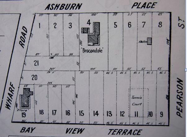
The stone markers were important in setting out the boundaries for subdivision such as the one shown. Photo source: Ryde Library.
Stone marker, corner of Ashburn Place and Wharf Road, Gladesville.
Wharf Road Properties
WALKING FROM ASHBURN STREET
Wharf Road was the central spine of William Billyard’s Glades Ville Estate of 1855. It connects the Great North Road (Victoria Road) with the river and is the second oldest official road in Gladesville.
Large blocks suitable for ‘villa residences’ were sold but building was slow. Over time further subdivision occurred but a number of properties retain their original style, and the street contains an interesting mix of architecture right through to recent constructions.
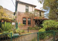
14a.
Ellora
LOCATION Corner of Wharf Road and Amiens Street (formerly Bay View Terrace) 54 Wharf Road / 19A Amiens Street, Gladesville
STYLE Victorian Georgian
YEAR 1865
The dwelling Ellora, opposite Woodstone (Item 18c) was built circa 1865. It is a substantial weatherboard house situated on a prominent corner site with a mature garden.
Ellora occupies Lot 58 of Billyard’s subdivision. It is associated with a number of prominent local people and their families – well-known solicitor and Alderman Thomas Salter, for whom the house was built and Mr. Gerrard Edgar Herring, Under Secretary for Lands and Mayor of Ryde in 1874, 1876 and 1880-1884, who was the owner from 1870. By 1876 the Herrings had built a second house of a similar size at the opposite end of the property,
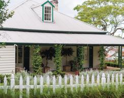
Ellora, 2025.
naming it Bracondale which became the Herrings’ family home while Ellora was tenanted by a Mr Folkard and later by the Reverend William Lumsdaine, Rector of Christ Church, Gladesville (item 5), who resided here from 1884-1902.
Not much is known on the occupants of Ellora after 1905 when the new rectory was completed at Christ Church; then in 1916/1919 after Gerrard Herring’s death one of his sons Sydney C.E. Herring subdivided and auctioned the Herring Estate including both houses.
Amiens Street was renamed after WWI to commemorate one of the 1916 battlefields on the Somme, France.

14b. Avondale
LOCATION 76 Wharf Road, Ryde
STYLE Late Victorian period house YEAR 1888
Once part of John Glade’s grant of 1802, the property went through various owners after 1838 and eventually, in 1887, was purchased by Sydney solicitor, Edwin Sandys Lumsdaine, the son of William Lumsdaine (Items 5 and 14a).
Lumsdaine oversaw the house being built in 1888 and named it Blanerne after family property in Berwickshire in Scotland. A later owner of the house, Alfred Edwin Knibbs named the house Ercildoune. It was named Avondale more recently.
2025.
The property has had several modifications over the years. The stables have been converted to a self-contained guesthouse and a swimming pool has been added. According to a 2012 real estate description, Edwin Lumsdaine had a small chapel built within the house, now used as a study.
Avondale,
Avondale, undated. Photo source: Ryde District Historical Society.
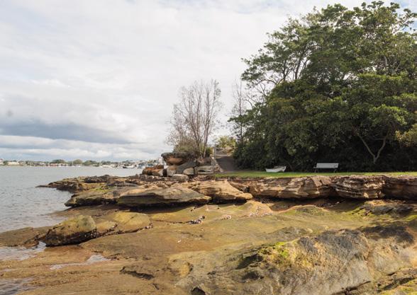
15 Meditation Park
LOCATION End of Wharf Road, Looking Glass Bay
In Meditation Park, adjacent to the boat house, a 1979 plaque commemorates this site as the probable location of the first meeting between Europeans and a local Aboriginal man of the Wallumudegal on 15 February 1788. The name of the Aboriginal man is not recorded but Governor Phillip and Lt W. Bradley came ashore near here and presented the Aboriginal man with a hatchet and a looking glass (mirror).

Plaque commemorating the landing by Governor Arthur Phillip. Photo source: Ryde Library.
16 First Post Office Site and Boat House
LOCATION Near the end of Wharf Road, Gladesville
YEAR 1861
Gladesville’s first post office was built at the end of Wharf Road in 1861, with William Billyard being responsible for construction. The first Postmaster was Mr Buckingham at a salary of £24 per year plus a commission on stamp sales. The Post Office later operated from Hannah Cowell’s cottage on the Great North Road near Batemans Road between 1867 and 1904. It then moved to a purpose built two storey brick building on the present site at 217 Victoria Road adjacent to the now closed Commonwealth Bank (Item 2b) from about 1914.
In 1940, the River Sailing Club was founded. It later became the Parramatta River Sailing Club following
its amalgamation with the Parramatta River Yacht Club. In 1952 members planned a new club house and acquired the c1920s crib room from the AGL Mortlake Gasworks (a major local employer located across the river). The building was relocated to the present site by floating it across the Parramatta River, where it was converted it into a new club house. New ramps, decks and space for boats were added.
The Boat House, 2025. Memorial plaque.

17 Gladesville Wharf
LOCATION At the end of Wharf Road, Gladesville YEAR 1859
The Glades Ville Estate developer, William Billyard, saw the need to connect his properties with river transport and he constructed a wharf at the end of his main road in 1859. At first it may have been a private facility ‘reserved for the use of the public upon the property’, but it functioned as a public wharf within a few years.

In the later 19th and early 20th Centuries the wharf would have been a good place from which to view the very popular professional sculling races along the river that ran just over 5km from the Meadowbank Railway Bridge to a finishing line at Searle’s monument on Three Brothers Rocks at Henley. The original timber structure where ferries berthed has been demolished.


Location of the former Wharf.
View of the wharf c1900. Photo source: Ryde Library.
18 18a. Wharf Road Properties WALKING
TO ASHBURN STREET

LOCATION 55 Wharf Road, Ryde
STYLE Victorian Italianate
YEAR c.1880
BUILDER Thomas Pidding
This land was once part of John Glade’s grant of 1802 and later became Lots 19 and 20 of the Glades Ville Estate.
Purchased by William Lowther on 9 October 1877, on 31 October 1879 the land was transferred to Thomas Smedley Pidding, who was a telegraph inspector, an Alderman on Ryde Municipal Council (1889-1891) and Mayor in 1896.
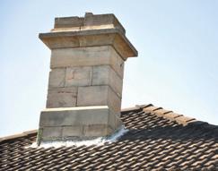
By April 1880 there was a house on the property known as, Euroma Cottage in 1883. Prior to the Presbyterian Church (Item 1) being built, meetings were conducted in this cottage. Pidding occupied the house until his death in 1922, and his wife, Jane O’Donnell Pidding stayed until her death the following year. The house displays an interesting variety of architectural detailing. Euroma, 2025.
Detailed view of the sandstone chimney.
Photo source: Ryde Library.
18b. Wimberdale and St Elmo
LOCATION 43-45 Wharf Road, Gladesville Wimberdale (No.43) and St Elmo (No.45)
STYLE Federation Queen Anne
YEAR 1914
Wimberdale, 2025.
St Elmo, 2025.
These two dwellings were built in 1914 on re-subdivision of an area first subdivided in 1876 and originally part of John Glade’s 1802 grant.
Both houses display architectural characteristics attributed to the Federation Queen Anne style of the early 20th Century, though there are a number of modifications.

18c. Woodstone
LOCATION 39 Wharf Road
STYLE Victorian Georgian
YEAR 1867, 1889 (modifications)

Historical Society.
Woodstone is associated with Walter Scott Campbell the son of Dr Francis Campbell, superintendent of the Gladesville Psychiatric Hospital. Walter grew up in Gladesville and recorded much of the local history including a great many Aboriginal rock engraving sites around Sydney. He was Chief Draftsman of the Department of Mines, later Chief Inspector of Agriculture, an Alderman in the first Ryde Council in 1871, and he contributed to the construction of Christ Church (Item 5).
W.S. Campbell constructed a four-room cottage with an attic on this site in 1867. This was extended by Edwin R. Mackenzie in 1889, sold to Frederick A. Elgood a dental surgeon in 1925, then to Malcolm H. Pike who added a mansard roof to the upper storey. In 1985 attempts were made to return the dwelling to its original form and in 1990 it was leased to the University of Technology, as the Vice Chancellor’s residence. The property was purchased by a private buyer in 2002 for residential use.
Woodstone, 2025.
Woodstone, 1996. Photo source: Ryde District
18d. The Pines and Speen
LOCATION 37 Wharf Road, and 36 Ashburn Place, Gladesville
STYLE Early Federation style
YEAR c.1890s
BUILDER E.R Mckenzie
The Pines stands on land that has been through various owners beginning with Lewis Gordon in 1836 and becoming part of the 1855 Glades Ville Estate. Edwin Robert Mackenzie who resided at Woodstone (now 39-41 Wharf Road, (Item 13b) reputedly built The Pines and the adjacent house Speen (36 Ashburn Place) for his two daughters in the early 1890s. The Pines was first occupied by Mabel Dalrymple Mackenzie.
Constructed of sandstone, it is a fine example of a single storey dwelling from the late 19th Century and is situated within a large, landscaped setting, now
partly screened from Wharf Road. It has been substantially modified in the 20th Century.
In the 1860s the Mackenzie family held grazing property in New England, and it seems that they retired to Gladesville. Edwin Robert Mackenzie died in 1896 and the properties at Gladesville were held in trust for his widow, Emma Louisa Mackenzie. After her death in 1907, the property remained in her name until 1923. Her son-in-law resided at The Pines until 1908, then moved into Woodstone.
The Pines. Photo source: Ryde Library.

19 Amiens Street
GROUP OF FEDERATION QUEEN ANNE STYLE DWELLINGS
LOCATION 23 – 31 Amiens Road, Gladesville
STYLE Federation Queen Anne YEAR c.1915-1920
The house belonging to John Glade, a third fleet convict after whom Gladesville is named, was located close to the present corner of Meriton and Amiens Streets. He had another near George Street.
Glade had been sentenced to seven years transportation for theft from a dwelling house of goods worth little more than six shillings. This land was originally 30 acres granted to John Doody who sold it to Marine Richard Paterson who put Glade in charge of developing a farm.
Glade was a good farmer and had 13 acres under wheat and maize growing
here by 1802 and was supporting three people ‘off stores’, meaning that they did not depend on the Government for provisions. By 1828 he held 140 acres with 40 acres cleared and six acres under cultivation. John Glade died in 1848 and is buried in St Annes Churchyard, Ryde.
A group of five houses (originally six) built between 1915 and 1920 probably by the same builder.
The group of dwellings each display similar architectural detailing which reinforces the early 20th Century period housing character of the street.
Amiens Street, 2025.

Amiens Street, 2025.
Amiens Street, 2025.
20 Glades Bay Park and Wulaba Track
LOCATION Accessed from Delmare Parade, Ashburn Place, York Street and Glades Avenue, Gladesville. A boardwalk extends around the waterfront to Bill Mitchell Park.

In 1969, the National Trust reported that ‘Glades Bay Reserve was an example of a foreshore area retaining sufficient elements of ‘naturalness’ to warrant retention and restoration’.
They recommended that, ‘every effort should be made to maintain, restore and accentuate the natural qualities of this reserve’. After considerable public discussion, Council established the Glades Bay Native Gardens as part of the Ryde Centenary Celebrations in 1970.

Monument commemorating the Ryde Centenary Celebrations in 1970.
Photo source: Ryde Library. Aboriginal rock carving depicting a wallaby.
The concept was that the park would be developed as an Australian wildflower garden. In 1943 natural vegetation in this area was sparse with exposed sandstone and patches of clearing. Mangroves were scattered along the shoreline. In the development of the ‘Native Garden’ sandstone lined garden beds were constructed and apparently planted with Australian species, but these were not of local stock. These beds may still be traced but the present ‘bush’ has regenerated from the mid-20th Century cover and some of the planted species. Dense mangroves, some Phragmites reed swamp, and small patches of saltmarsh now line the riverbank.
Half of this land was in the Doody/ Benson grant of 1795/96 and the remainder was in John Glade’s grant of 1802.


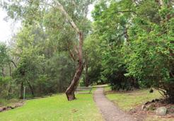
It is also one of the few places in Gladesville where evidence remains of the original inhabitants – the Wallumedegal. Their sites are interpreted along a newly refurbished walkway that goes through the park and along the river’s edge, past the site of Glades Bay Baths to Bill Mitchell Park. First constructed as the Wulaba Track in 2002 by Ryde Council in consultation with the Metropolitan Local Aboriginal Land Council, the track has a number of interpretive signs.
