Technical Memorandum
To: Eric Holder, Independence Power & Light
From: Andrea Collier and Tony Schroer, Barr Engineering Co.
Subject: 2021 Blue Valley Facility CCR Impoundment Groundwater Monitoring Report
Date: January 28, 2022
Project: 25491019 .00
c: James Barry, Independence Power & Light Rob Morrison, Barr Engineering Co.
1.0 Introduction
On behalf of the Independence Power and Light (IPL), Barr Engineering Co. (Barr) has prepared this 2021 Groundwater Monitoring Report for the IPL Blue Valley Power Plant Facility located at 21500 East Truman Road in Independence, Missouri (Site) (Figure 1 in Attachment A).
Project activities conducted in September and November 2021 included routine groundwater monitoring and well inspections. This report presents the field data and analytical results for the Third and Fourth Quarter 2021 monitoring events

1.1 Site Background
The Facility was constructed in 1958 as a tri-fuel steam electric power plant that burned coal, diesel, and natural gas until 2015, when it ceased power production from coal and diesel and was converted to a natural gas facility. Two of the original CCR impoundments, the south fly ash pond, and bottom ash pond were built in 1978. The north fly ash pond was constructed in 1989. The Facility sluiced bottom ash and fly ash into the ponds until 2015. Upon the discontinuation of ash sluicing into the CCR impoundments, the former impoundments became “inactive surface impoundments” subject to the requirements of the Federal CCR Rule, 40 CFR 257.100, Subpart D. The Notice of Closure Completion for all three former impoundments was submitted to MDNR in December 19, 2017
The Site is located approximately seven miles south of the Missouri River in the north central portion of Jackson County at 21500 East Truman Road in Independence, Missouri in Section 3, Township 49N, and Range 31W. Figure 2 displays the Site location and impoundment boundary. The Site is located within the Central Irregular Plains Ecoregion of west central Missouri. Potential natural vegetation of this ecoregion includes a mix of grassland and forest, with forested areas particularly located along streams (Purdue, 2020). Land use adjacent to the Site, displayed on Figure 2 (Attachment A), is primarily industrial and agricultural, with industries located north, south, and west of the Site and agricultural land located to the east. An isolated residential area is also located north of the Site.
Regional topography is characterized by hills and associated dendritic drainage patterns with approximately 150 feet of relief within one mile of the Site. Hills north and west of the Facility have
To: Eric Holder, Independence Power & Light
From: Andrea
Collier andAndrea
Collier and Tony Schroer, Barr Engineering Co.Subject: 2021 Blue Valley Facility CCR Impoundment 2021 Blue Valley Facility CCR Impoundment Groundwater
Monitoring Report
Date: January 28, 2022
Page: 2
elevations as high as 900 feet above mean sea level (MSL) The Site has features with elevations that range from approximately 750 to 800 feet above MSL and slope from the northwest to southeast (Figure 1 in Attachment A). A topographic divide, located in the southwest portion of the Site, separates the Little Blue River and Burr Oak-Creek-Little Blue River subwatersheds (Hydrologic Unit Code 12).
1.2 Regional Geology
The surficial soils of the region and portions of the Site outside the former impoundments consist primarily of unconsolidated alluvial sediments known as the Sibley Silt Loam series According to the Soil Survey of Jackson County, Missouri (1984) developed by the United States Department of Agriculture (USDA), the Sibley Silt Loam is a friable, moderate permeability soil with naturally high fertility (USDA, 1984). The surface layer is generally dark brown, the middle sections can be dark brown to grey, and the lower sections are generally more clayey and dark yellowish-brown with various mottles.
Based on the report, City of Independence, Missouri, Blue Valley Generating Station Ash Pond Addition and Other Improvements (Burns and McDonnell, 1977), the subsurface soil in the proximity of the former impoundments consists primarily of silty clay with interbedded seams of fine-grained, uncompacted sandy silt. The report provides descriptive logs for 27 borings drilled in a grid pattern encompassing the area of the former fly ash and bottom ash ponds. The borings ranged in depth from 10 feet to 64 feet bgs
The bedrock underlying the region and Site consists of Pennsylvanian aged shales, limestones, sandstone, and siltstones with interbedded coal seams. The Pennsylvanian-aged shales overly older Mississippian aged formations (MDNR, 1997).
The Pennsylvanian-aged Pleasanton Group is the first bedrock unit encountered in the region, located approximately 25 feet bgs. The Pleasanton Group is predominantly a thick unit of shale with limestone and a basal unit of siltstone or very fined-grained sandstone Two additional sandstone units, which combined are known as the Warrensburg Sandstone, are sometimes present in the upper half of the group depending on the location. The base of the Pleasanton Group marks a break in the depositional sequence occurring in the Pennsylvanian time. This break in the depositional sequence forms a regional disconformity. Underlying the Pleasanton Group bedrock unit is the Marmaton Group. The Marmaton Group is comprised mainly of thick shales with intervening thin layers of limestone and sandstone.
1.3 Regional Hydrogeology
The hydrogeology in the area of the Site is represented by the Missouri River alluvium and Lake City alluvium, two groundwater subprovinces of the West-Central groundwater province. The Site is primarily located within the Missouri River alluvium, which borders the Lake City alluvium just east of the Site near the Little Blue River. Information describing the West-Central groundwater province and each subprovince is provided below.
To: Eric Holder, Independence Power & Light
From: Andrea Collier and Andrea Collier and Tony Schroer, Barr Engineering Co.Subject: 2021 Blue Valley Facility CCR Impoundment 2021 Blue Valley Facility CCR Impoundment Groundwater Monitoring Report
Date: January 28, 2022
Page: 3
The West-Central groundwater province is bounded by the Missouri River to the north, the Springfield Plateau groundwater province to the south and east, and the Kansas state boundary to the west. The greatest potential for groundwater yield within this province is from the alluvial deposits along the northern edge of the province, which include the Missouri River alluvium and Lake City alluvium, further described below. Pennsylvanian-aged formations comprise the bedrock surface units for most of this groundwater province, specifically the Pleasanton and Marmaton Groups in the area of the Site The Pleasanton and Marmaton Groups in the region have low recharge potential due to their extremely low horizontal and vertical permeabilities and are not considered to be water bearing; the Pleasanton Group is considered to be less productive than the Marmaton Group (MDNR, 2021). Of the small amounts of groundwater that may potentially be drawn from these groups, the groundwater is expected to be of poor quality.
The Missouri River alluvium province is located at the northern portion of the West-Central groundwater province and extends for the entire length of the Missouri River throughout the state with an aerial extent of approximately 440 square miles in the vicinity of the Site. The Missouri River alluvium formed from glacial meltwater runoff during the Pleistocene epoch (Ice Age); the melt water transported a significant amount of sediments that ranged in size from clay particles to boulders, which carved a river channel much wider than the channel occupied by the Missouri River today. Following the Pleistocene epoch, over-bank flooding of present-day rivers has deposited additional alluvium on river floodplains. The Missouri River and the Missouri River alluvium province experience delayed recharge; studies of wells within the alluvium indicated a delayed response of several days between river stages and groundwater levels. Under normal flow conditions in the Missouri River, groundwater gradients in the Missouri River alluvium are toward the river (MDNR, 1997).
In the report Groundwater Resources of Missouri (MDNR, 1997), the Missouri River alluvium is divided into four segments from the Iowa border to St. Charles, prior to the Missouri River and Mississippi River confluence. For the purpose of this project, the portion of the Missouri River alluvium province discussed in this section is the Kansas City to Miami, Missouri segment. The Missouri River alluvium in this segment composed primarily of fine sand, silt, and clay with coarse sands and gravels comprising the deeper portions of the alluvium. The alluvium has a maximum thickness of 140 feet and an average thickness of 85 to 90 feet. The average saturated thickness of the alluvium is approximately 75 feet for this area. Groundwater from wells within the Missouri River alluvium supplies a majority of the potable water in the Kansas City area. Yields from the Missouri River alluvium may reach 1,000 to 1,500 gallons per minute (gpm) in the more permeable areas of the alluvium (MDNR, 1997).
The Lake City alluvium groundwater subprovince is a 16-mile-long, 1-2-mile wide channel that begins at the southern edge of the Missouri River alluvium in central Jackson County near the town of Atherton, extends southeast to Lake City, and then trends northeast until it again intersects with the Missouri River alluvium in northeastern Jackson County near the town of Levasy. The Lake City alluvial channel likely formed as a result of an ice damming event on the ancestral Missouri River, which forced the river south
To: Eric Holder, Independence Power & Light
From: Andrea Collier and Andrea Collier and Tony Schroer, Barr
Engineering Co.Subject: 2021 Blue Valley Facility CCR Impoundment 2021 Blue Valley Facility CCR Impoundment Groundwater Monitoring Report
Date: January 28, 2022
Page: 4
of the existing channel and eroded the new channel, which currently serves as the river valley for the Little Blue River from Lake City to the Missouri River. The Site is located on the western edge of the Lake City alluvium channel. A study of this alluvium aquifer at the Lake City Army Ammunition Plant in the early 1940s estimated the alluvium’s thickness to 80 to 90 feet with a depth to water of 15 to 20 feet bgs. Well pumping rates during this study reached 300 to 400 gpm (MDNR, 1997).
2.0 Hydrogeologic Data and Monitoring
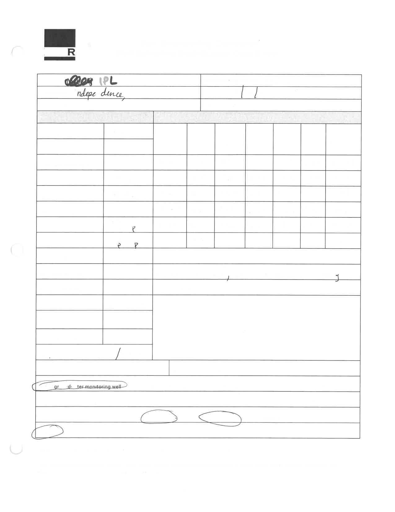
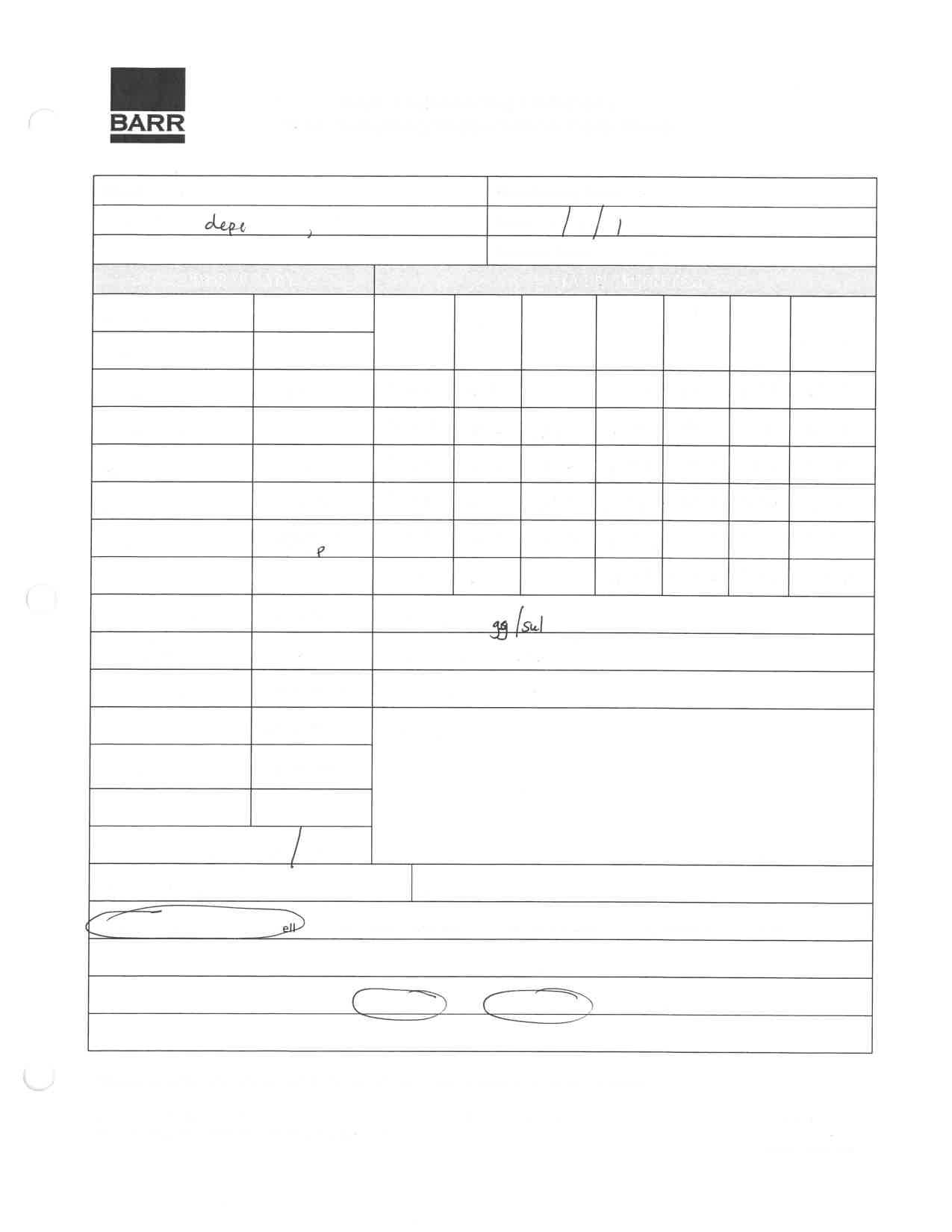
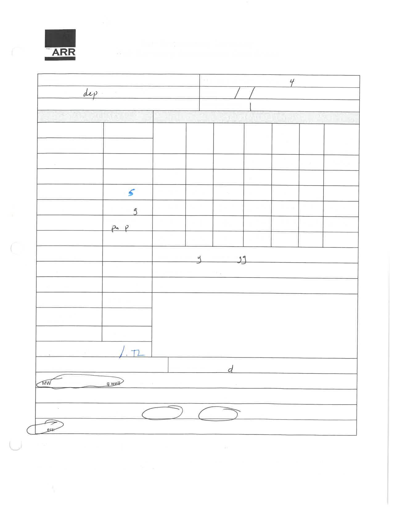
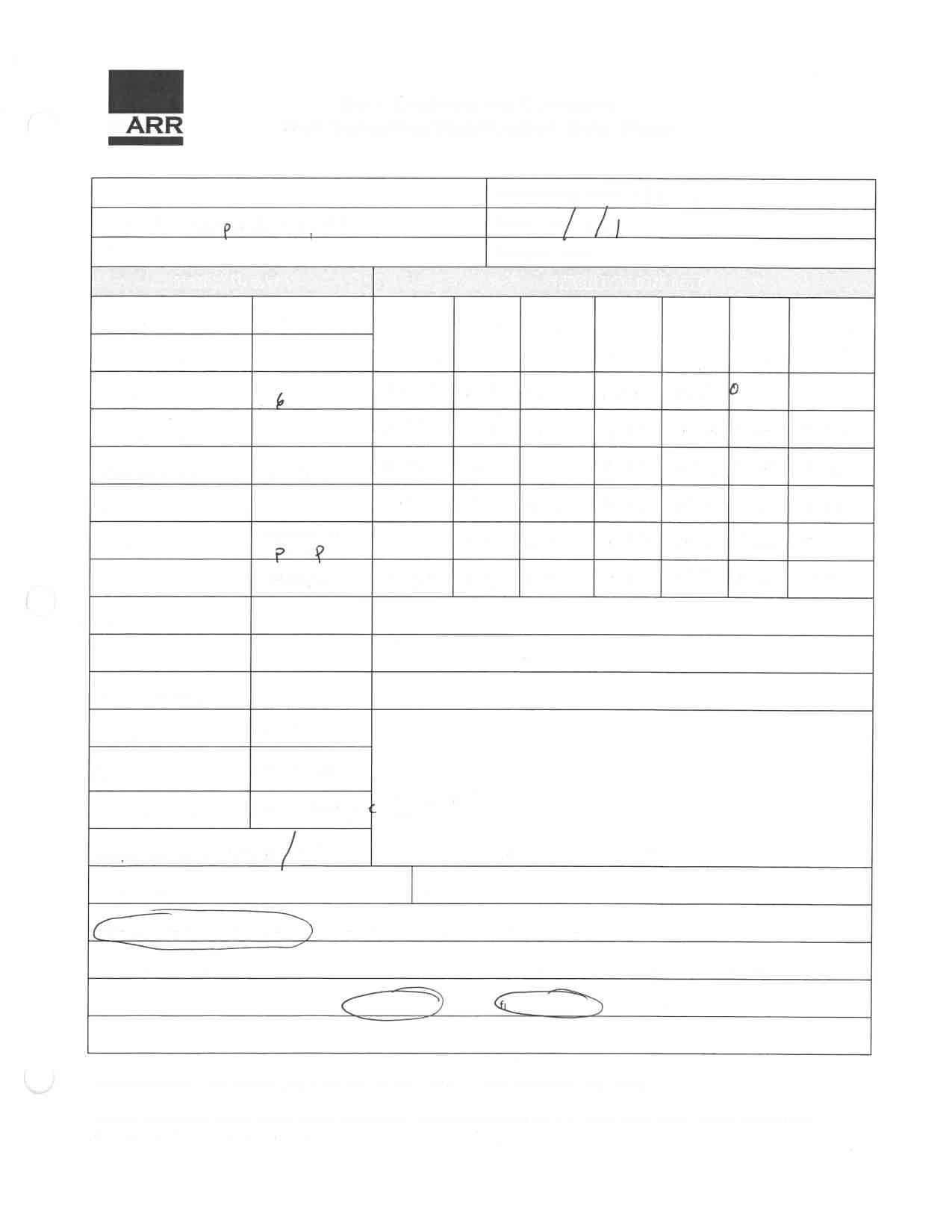
Hydrogeologic monitoring at the Site includes the collection of groundwater elevation data from Site monitoring wells. The monitoring well locations at the Site are shown on Figure 3 (Attachment A) and well construction information is located in Table 1 (Attachment B)
2.1 Potentiometric Surface Measurements
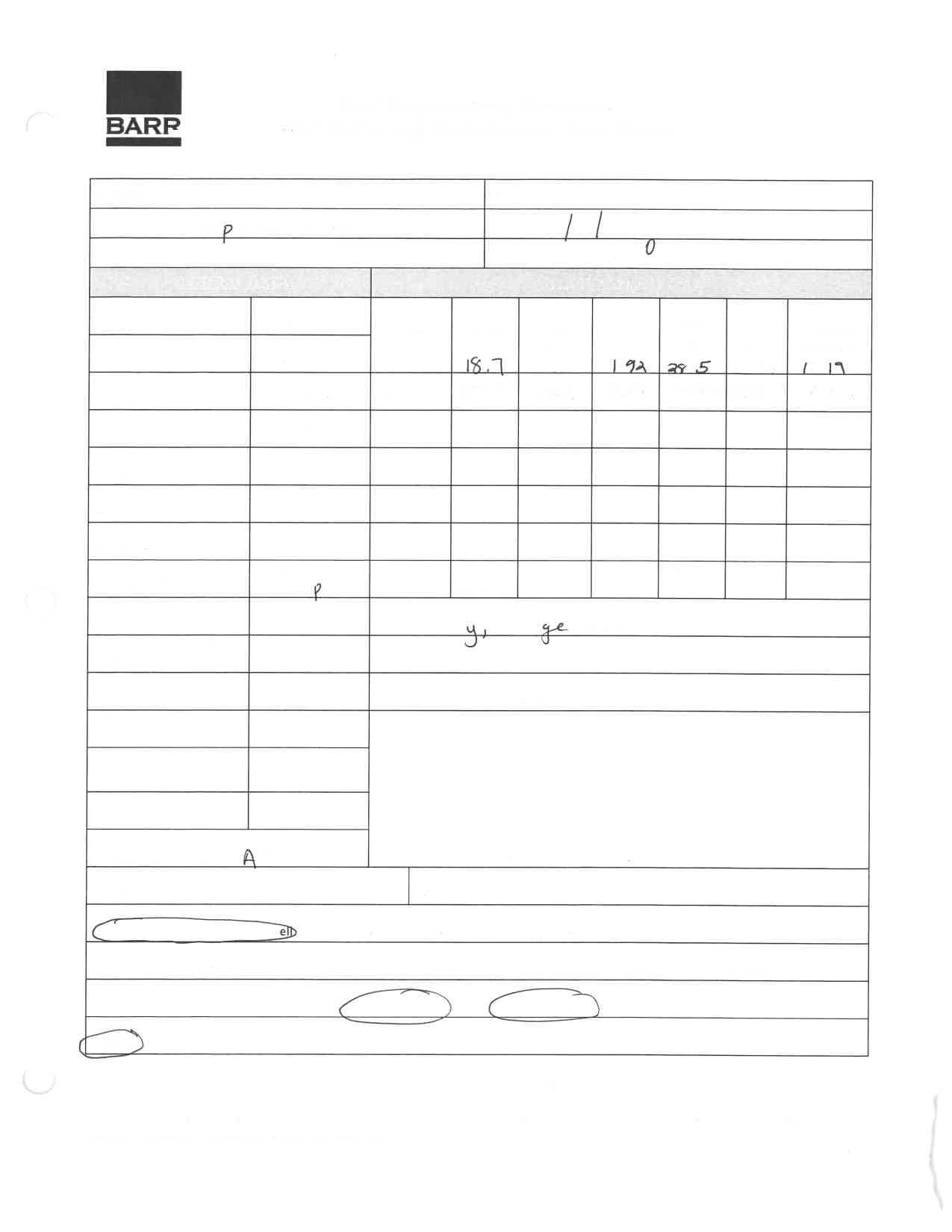
During the Third and Fourth Quarter 2021 monitoring events, water-levels were collected from the eight (8) routinely scheduled groundwater monitoring wells. The resultant elevation data were used to develop a flow map, assess flow direction, and calculate gradients for the shallow groundwater. A summary of all groundwater elevation data is included as Table 2.
2.2 Groundwater Flow Direction and Gradient
The groundwater elevation data from the Site’s shallow monitoring wells were contoured to construct a potentiometric surface map (Figures 4 and 5). As graphically illustrated on Figures 4 and 5, groundwater flows towards the east which is consistent with historic water elevation data for the Site.
The calculated hydraulic gradient for the Third and Fourth Quarter 2021 monitoring events is approximately:
Horizontal gradients measured across the Site range from -0.006 to 0.02 (range for gradients from three different areas of the Site.) for the Third and Fourth Quarter 2021 groundwater elevation data (Table 2Attachment B). The horizontal gradient measured across the northwestern portion of the Site (MW-6 to MW-8) was calculated to be -0.01 for September 2021 and -0.006 to November 2021. The horizontal gradient measured across the northeastern portion of the Site (MW-1 to MW-8) was calculated to be 0.02 for September 2021 and -0.0067 to November 2021. The horizontal gradient measured across the central portion of the Site (MW-7 to MW-4) was calculated to be 0.014 for September 2021 The water level measured for MW-7 during the November sampling event was not utilized for hydraulic gradient
To: Eric Holder, Independence Power & Light
From: Andrea Collier and Andrea Collier and Tony Schroer, Barr Engineering Co.Subject: 2021 Blue Valley Facility CCR Impoundment 2021 Blue Valley Facility CCR Impoundment Groundwater Monitoring Report
Date: January 28, 2022
Page: 5
measurements because the well was purged two weeks prior to sampling and the water level had not restabilized.
The average hydraulic gradient is towards the east with a slope of approximately 0.008 for September and 0.0003 for November across the entire Site. This slope is relatively shallow as compared to previous years (2019 and 2020) likely due to the varying water elevations in the upgradient monitoring wells An approximate average interstitial velocity across the Site has been estimated to range from 3 42 x 10-3 feet/day to 1.24 x 10⁻² feet/day (i.e. 1.25 to 4.5 feet/year) for September 2021 and 1.28 x 10⁻⁴ feet/day to 4.66 x 10⁻⁴feet/day (i.e. 0.047 to 0.17 feet/year) for November 2021 as calculated by the following equation and input data:
v = Ki/n, where
v = average interstitial velocity
K = hydraulic conductivity (ranges from 0.388 to 0.171 feet/day)
i = average hydraulic gradient across the Site (0.005)
n = effective porosity (estimated to range from 0.25 to 0.4)
2.3 Groundwater Hydrographs
Overall, groundwater elevations measured in wells during the Third and Fourth Quarter 2021 monitoring events were relatively consistent with the data from the measurements taken during the previous events (Barr, 2020).
Due to the relatively higher recharge rates the downgradient well groundwater elevations have not changed significantly from previous monitoring periods. The greatest difference of water levels observed in the downgradient wells is approximately 3.74 feet in monitoring well MW-5. This groundwater elevation change represents measurements with seasonal flux and significantly drier/wetter periods.
The groundwater elevation changes in the upgradient wells are significantly more prominent than the changes observed in the downgradient wells. The groundwater elevations for the upgradient wells have been observed to change up to 8.8 feet (MW-8) after stabilization of the water levels within the wells. Currently, the cause of the significant differences in the upgradient water levels is unknown, but it is likely due in part to the fine-grained material in the subsurface in that part of the Site.
Groundwater levels for active monitoring wells are presented in Table 2 (Attachment B).
2.4 Groundwater Monitoring Network
No modifications have been made to the monitoring network since well installation in 2019
To: Eric Holder, Independence Power & Light
From:
Andrea Collier and Andrea Collier and Tony Schroer, Barr Engineering Co.Subject: 2021 Blue Valley Facility CCR Impoundment 2021 Blue Valley Facility CCR Impoundment Groundwater Monitoring Report
Date: January 28, 2022
Page: 6
3.0 Groundwater Sampling and Field Activities
The field methods for the collection of the samples are described in the Groundwater Monitoring Sampling and Analysis Plan (GMSAP) (Barr, 2021)
3.1 Well Inspections
During the Third and Fourth Quarter 2021 monitoring events, the sampling crew measured the static water levels in each of the eight active monitoring wells at the site and visually inspected each well’s condition. Any evidence of well damage was documented in the field documents (Attachment C). Table 1 (Attachment B) contains a summary of the monitoring well construction including well number designation, measured total depth, elevation for top of screen, and the measured static water level for each well.
3.2 Sample Collection
Groundwater samples were collected at two quarterly sampling events (September 2021 and November 2021) from the eight active monitoring wells at the Site. Groundwater sampling was conducted using passive and low stress (low flow) methodology in compliance with the GMSAP (Barr, 2021). For the wells sampled via low stress (low flow) methodology, a submersible pump was lowered into the well screen and pumped at the lowest possible rate until measurements of temperature, pH, specific conductivity, dissolved oxygen, turbidity, and ORP stabilized. These parameters can be found on the field logs in Attachment C. The low flow sampling was performed in compliance with Section 3.0, Section 4.0, and Appendix D of the GMSAP.
For the wells sampled via passive sampling methodology, Snap Sampler columns were placed in the wells at least two weeks prior to the sampling events. During the sampling event the Snap Sampler releases were triggered, and the sample column was removed from the wells. The passive sampling was performed in compliance with Section 3.0, Section 4.0, and Appendix D of the GMSAP.
For quality control (QC) purposes duplicate samples were collected during each sampling event. During both the September and November 2021 sampling events, duplicate samples were collected from downgradient well MW-5.
4.0 Groundwater Analytical Results
4.1 September 2021
Groundwater samples were collected at all monitoring wells installed at the Site. Table 3 (Attachment B) summarizes the groundwater concentration data from the wells and compares the concentrations against EPA’s MCLs (40 CFR 141.62 and 257.95). Groundwater samples from the September 2021 sampling event that exceeded EPA’s MCLs are shown on Figure 6 (Attachment A).
To: Eric Holder, Independence Power & Light
From: Andrea Collier and Andrea
Collier and Tony Schroer, Barr Engineering Co.Subject: 2021 Blue Valley Facility CCR Impoundment 2021 Blue Valley Facility CCR Impoundment Groundwater Monitoring Report
Date: January 28, 2022
Page: 7
Groundwater concentration exceedances of the EPA MCLs for dissolved/total arsenic and dissolved/total lithium were identified in some of the samples. The following list summarizes the exceedances for each constituent:
• Dissolved and total arsenic: Groundwater concentrations exceeded the arsenic MCL of 10 µg/L at monitoring wells MW-3, MW-4, MW-7, and MW-8. Dissolved arsenic concentrations at these four wells ranged from 10.8 to 12.3 µg/L and total arsenic concentrations at the wells ranged from 15.5 to 48.8 µg/L.
• Dissolved and total lithium: Groundwater concentrations at upgradient wells MW-6 MW-7, and MW-8 exceeded the lithium MCL of 40 µg/L. Dissolved lithium concentrations at these three wells ranged from 300 to 478 µg/L and total lithium concentrations at the wells ranged from 58.5 to 426 µg/L.
4.2 November 2021
During the November 2021 sampling event, groundwater samples were collected from all eight monitoring wells installed at the Site. Groundwater samples from the November 2021 sampling event that exceeded EPA’s MCLs on Figure 7 (Attachment A).
Groundwater concentration exceedances of the EPA MCLs for dissolved and total arsenic and dissolved/total lithium were identified in some of the samples. The following list summarizes the exceedances for each constituent:
• Total arsenic: groundwater concentrations exceeded the arsenic MCL of 10 µg/L at downgradient monitoring wells MW-1, MW-3, and MW-4. Total arsenic concentrations at these three wells ranged from 20.2 to 42.1 µg/L
• Dissolved and total lithium: Groundwater concentrations at upgradient wells MW-6 and MW-8 exceeded the lithium MCL of 40 µg/L. The dissolved and total lithium concentrations at well MW-8 were 558 µg/L and 361 µg/L, respectively. The concentration of dissolved lithium at well MW-6 (47.6 µg/L) also exceeded the 40 µg/L MCL.
5.0 Conclusions and Recommendations
The results of the 2021 groundwater sampling events at the Site have been summarized in the previous sections and the conclusions and recommendations based on those results are outlined in the following paragraphs.
5.1 Site Groundwater
Upgradient and downgradient groundwater sample concentrations indicate that the groundwater contains metals concentrations. The metals concentrations for arsenic and lithium exceed the MCLs in some of the upgradient and downgradient wells. As discussed in the Site Characterization Report (Barr, 2020), the native materials at the Site contain concentrations of metals that exceed the MRBCA Default
To: Eric Holder, Independence Power & Light
From:
Andrea Collier and Andrea Collier and Tony Schroer, Barr Engineering Co.Subject: 2021 Blue Valley Facility CCR Impoundment 2021 Blue Valley Facility CCR Impoundment Groundwater Monitoring Report
Date: January 28, 2022
Page: 8
Target Levels and are naturally-occurring metals in the native materials that are typically associated with CCR material. Therefore, the native soil around the former impoundments are likely to be a source for metals in the groundwater.
As a result, groundwater monitoring in compliance with the proposed GMSAP will be utilized to continue monitoring these and other parameters to identify their potential source and representativeness in the shallow groundwater.
5.2 Groundwater Flow
Results of the Site Characterization Report (Barr, 2020) indicates that the shallow groundwater underlying the site migrates slowly due to the fine-grained nature/low permeability of the unconsolidated units underlying the former impoundments.
The groundwater data continues to be consistent with previous observations made regarding groundwater flow and direction. The groundwater flow at the Site is primarily to the east/southeast and groundwater underlying the former impoundments migrates primarily through the sand layers in the unconsolidated units.
Since groundwater contact with the impoundment material is limited, it is unlikely that leaching of metals from CCR materials is occurring via lateral groundwater movement through the former impoundment. In addition, to date, groundwater elevations measured from groundwater wells do not indicate that groundwater is migrating through CCR materials in the northwest corner of the impoundment area. Therefore, the potential for COCs to migrate is primarily via vertical leaching of the low volumes of meteoric water that have infiltrated through the engineered cap.
6.0 References
Barr, 2021. Blue Valley Coal Combustion Residuals Impoundment Groundwater Monitoring Sampling and Analysis Plan, Independence Power and Light Blue Valley Power Plant, Independence, Missouri. July 2021
Barr, 2020 Blue Valley Coal Combustion Residuals Impoundment Site Characterization Report, Independence Power and Light Blue Valley Power Plant, Independence, Missouri. May 2020.
Burns and McDonnell, 1977 City of Independence, Missouri, Blue Valley Generating Station Ash Pond Addition and Other Improvements, May 1977.
Freeze, R. A. and J. A. Cherry, 1979. Groundwater, Prentice-Hall, Inc., Englewood Cliffs, New Jersey, 604p.
Missouri Department of Natural Resources, 2021. Geosciences Technical Resources Assessment Tool Website, URL: https://dnr.mo.gov/geology/geostrat.htm. Accessed January 2020.
To: Eric Holder, Independence Power & Light
From: Andrea Collier and Andrea Collier and Tony Schroer, Barr Engineering Co.
Subject: 2021 Blue Valley Facility CCR Impoundment 2021 Blue Valley Facility CCR Impoundment Groundwater
Monitoring Report
Date: January 28, 2022
Page: 9
Missouri Department of Natural Resources Division of Geology and Land Survey, 1997. Groundwater Resources of Missouri, Don E. Miller, 1997.
Purdue University, 2020. Primary Distinguishing Characteristics of Level III Ecoregions of the Continental United States Website, URL: https://hort.purdue.edu/newcrop/cropmap/ecoreg/descript.html#40 Accessed July – September, 2019.
US Department of Agriculture, 1984. Soil Survey of Jackson County, Missouri. September 1984
Attachments
Attachment A – Figures
Attachment B – Tables
Attachment C – Field Data
Figures
Perennial
Intermittent
Property

Freshwater
Freshwater
Freshwater
North Fly Ash Impoundment (Closed)
Earley Machine LLC Earley Machine LLC

HEMCO Corporation HEMCO Corporation
Independence Independence School District School District Transportation Complex Transportation Complex
South Fly Ash Impoundment (Closed) Bottom Ash Impoundment (Closed)
Bottom Ash Impoundment (Clean Closure and Converted to a Sedimentation Basin)
Midwest Directional Midwest Directional Services Services
Continental Continental Manufacturing Manufacturing Watco Manufacturing Co. Watco Manufacturing Co.
Metal Sale Metal Sale Manufacturing Corporation Manufacturing Corporation
Barbour Concrete Company Barbour Concrete Company
Note:
Property boundary obtained from Jackson County parcel dataset, MO GIS Department.
Imagery: Nearmap, September 2021
Note:
Property boundary obtained from Jackson County parcel dataset, MO GIS Department.
Imagery: Nearmap, September 2021
Groundwater Elevation Summary - September and November 2021