Issued Prepared for City of Canada Bay Sydney Metro West Planning Study Stage
Final Report Urban Design Framework Stage 3 - Post exhibition final - May 2023 City of Canada Bay SJB Urban Level 2, 490 Crown Street Surry Hills NSW 2010 Australia T. 61 2 9380 9911 architects@sjb.com.au sjb.com.au
3:
We create amazing places
Version: 05
Prepared by: KC, FS, LV
Checked by: FL, JK
Contact Details:
SJB Urban Level 2, 490 Crown Street Surry Hills NSW 2010 Australia
T. 61 2 9380 9911 architects@sjb.com.au sjb.com.au
SJB Architecture (NSW) Pty Ltd
ABN 20 310 373 425
ACN 081 094 724
Adam Haddow 7188 John Pradel 7004
Issued Draft for review 28.05.2021 Draft for review 16.05.2021 Draft for exhibition 01.07.2021 Post exhibition draft 23.12.2022 Post exhibition draft 07.02.2023 Post exhibition final 26.05.2023
At SJB we believe that the future of the city is in generating a rich urban experience through the delivery of density and activity, facilitated by land uses, at various scales, designed for everyone.
Contents 1 Report Overview 4 1.1 Executive summary 4 1.2 Approach to Stage 2 - The Framework 5 1.3 Approach to Stage 2 - Outcomes 6 1.4 Key moves 7 2 The Context 8 2.1 Strategic drivers 8 2.2 Sydney Metro West 9 2.3 Overarching urban design principles 11 3 Five Dock 13 3.2 Challenges 14 3.3 Opportunities 15 3.4 Vision 16 3.5 Five Dock preferred structure plan 19 3.6 Five Dock - design recommendations 20 3.7 Five Dock potential built form massing 21 3.8 Open space, public domain and community framework plan 23 3.9 Movement and access framework plan 24 3.10 Land use and activity framework plan 27 3.11 Built form and heritage framework plan 28 4 Concord 30 4.1 Challenges 31 4.2 Opportunities 32 4.3 Vision 33 4.4 Concord preferred structure plan 36 4.5 Concord - Design recommendations 37 4.6 Concord potential built form massing 38 4.7 Open space, public domain and community framework plan 40 4.8 Movement and access framework plan 41 4.9 Land use and activity framework plan 43 4.10 Built form and heritage framework plan 44 5 North Strathfield 47 5.1 Challenges 48 5.2 Opportunities 49 5.3 Vision 50 5.4 North Strathfield preferred structure plan 53 5.5 North Strathfield - Design recommendations 54 5.6 North Strathfield potential built form massing 55 5.7 Open space, public domain and community framework plan 57 5.8 Movement and access framework plan 58 5.9 Land use and activity framework plan 60 5.10 Built form and heritage framework plan 61
Overview
1.1 Executive summary
The Purpose
The purpose of this report is to provide City of Canada Bay (CCB) with a study of the opportunities created by the delivery of Sydney Metro West. The study focuses on strategic issues which can be used in collaboration and discussion with Sydney Metro and other government agencies.
The key objectives of the planning study are to:
Identify a strategic vision for North Strathfield, Concord and Five Dock unlocked by Sydney Metro and ensure that this vision is reflected in public domain, land use and built form outcomes
· Identify opportunities for new and/or improved areas of open space and social infrastructure within and around new Metro locations
Identify opportunities for and facilitate improvements to the public domain to maximise pedestrian amenity, movement and experience
Established preferred land uses within and around new Metro locations, addressing established character and heritage buildings
· Ensure that employment functions around station locations are supported and enhanced Establish preferred built form outcomes and building typologies within and around new Metro locations.
North Strathfield
A strategic interchange connecting the existing suburban station of the T9 Northern Line allowing for faster connections from Sydney’s north to Parramatta and Sydney CBD through a quick and easy transfer between suburban and metro services. This connection has the opportunity to be anchored around a vibrant hub.
Concord
The Concord Precinct will build on the visions and aspirations of the PRCUTS whilst creating new linkages and connections to service the Burwood Town Centre and the residential population to the north of the new station. The location of the precinct will also support nearby regional sporting and employment functions.
Five Dock
As an origin and destination precinct, Five Dock has a well established retail and residential character, well serviced by bus routes. A new metro station will service this existing centre and can be a catalyst to further unlock opportunities within this precinct.
4 City of Canada Bay SJB
Report
1
FIVE DOCK Concord PARRAMATTA RIVER Queen Elizabeth Park Massey Park Golf Course Concord Golf Course St Lukes Park 800m 800m 800m 400m 400m 400m Concord Oval Barnwell Golf Course NORTH STRATHFIELD
The Study Precincts
Parramatta Road Great North Road Concord Road GippsStreet Queens Road
1.2 Approach to Stage 2 - The Framework
The Process
The process included collaborative workshopping of ideas and built form testing with Council’s strategic planning team to ensure that the vision for each Precinct aligns with aspirations envisaged by Council’s existing strategic planning documents. The study is divided into two stages:
Stage 1: Background Report and Project Visioning
A review and summary of the key strategic documents to examine opportunities to integrate the key visions and objectives from transport infrastructure and land use planning to support the delivery of the Sydney Metro West and its impact to the surrounding context.
Stage 2: Final Report - Urban Design Framework
Preparation of an urban design framework for each Precinct that integrated the findings of Stage 1 to test into a future plan for each precinct this includes;
A structure plan (overall vision)
An urban design framework:
· Open Space, Public Domain and Community facilities
· Movement and Access
Land Use and Activity
Built Form and Character
A series of options were developed testing a range of development scenarios to inform the preferred plan.
The framework outlined below illustrates how the vision has been identified, refined and referenced throughout the design process. The framework also focuses on meeting the objectives of the precincts, which includes significant employment targets, improving amenity and strengthening local character.
1. - Understand Place and Future Vision 2. - Create a Structure Plan
The first step in the Structure Plan process was to recognise the places, goals, aspirations and objectives articulated by a vision. The vision seeks the creation of a resilient, liveable, responsive, equitable and integrated environment that builds on existing place making qualities.
The second step was to identify the key factors that have informed our understanding of the key opportunities and challenges. Key challenges include lack of open space and provision of future commercial floor space. The creation of a Structure Plan, which has been informed by a vision incorporating existing and future character elements, public domain, built form, movement and access. The Structure Plan identifies priority actions and directions to ensure the vision is achieved.
3. - Refine through Framework 4. - Design Testing
The third step was to refine the Structure Plan with Framework Plans that convey how the priorities for the Plan can be achieved by addressing key issues through responsive principles and criteria.
The fourth step entailed built form testing outcomes to be tested against the design principles outlined in the framework plans to establish a preferred approach to built form that aligns with the vision and principles.
5. - Finalisation of Plans
From the process of the built form testing, updates are made to finalise the Structure Plan and Urban Design Frameworks to reflect the feasibility of the preferred options.
5 City of Canada Bay SJB Report Overview
Baseline mapping Character statement Site analysis Vision Opportunities & Challenges Principles Vision Structure Plan Open space & Public domain Land use & Activity Movement & Access Framework Built Form Controls Typology Testing Recommendations Principles Statements Finalisation Built Form & Character
1.3 Approach to Stage 2 - Outcomes

The following is a representation of the structure of the outcomes for each Precinct:


Principles & Vision
A workshop was held early in the study process to gain a better appreciation of the challenges, opportunities and aspirations of each Precinct and to summarise this vision through a brainstorming exercise.
Structure Plan
Structure Plans were produced as a synthesis of the principles and visioning exercise as well as information analysed in the baseline documentation of the background reports in Stage 1. The Plans shown within this report are the preferred options, other options were developed as part of an iterative process with Council, these options are found in the Appendix. The Structure Plan is the basis for the Urban Design Framework.
Design Testing


Opportunities to test the built form recommendations ensured that the Structure Plans had veracity and are aligned to Council’s future vision. Built form testing allows for future population, commercial floorspace and dwelling targets to be calculated.
Urban Design Framework

The Structure Plan is distilled into the following Framework:
Structure Plan


Open Space, Public Domain and Community Framework Movement and Access Framework


Built Form, Heritage and Development Framework
Land Use and Activity Framework

6 City of Canada Bay SJB Report Overview
1.4 Key moves
The following are the key moves for each Precinct based on the understanding of each Metro station’s role within the corridor as identified in Stage 1.
Five Dock
Role within the Metro corridor
An origin and destination precinct with a strong retail and residential character. It is a centre that is a wellconnected attractor and place to both live and work.
Existing condition
Strong focus on the town centre spine along Great North Road but disconnected to the surrounding area.
Concord
· Role within the Metro corridor
An employment and sporting destination hub which integrates the visions and aspirations of the PRCUTS within the broader transport network.
Existing condition
Constrained by Parramatta Road and limited connectivity north/south. Lack of facilities and services north of Parramatta Road (mostly located south in neighbouring Burwood).
North Strathfield
Role within the Metro corridor
A strategic interchange allowing for faster connections from Sydney’s north to Parramatta and Sydney CBD through a quick and easy transfer between suburban and metro services at a vibrant hub.
Existing condition
Heavily constrained by existing rail corridor and Parramatta Road and limited connectivity east to west.
Proposed key moves
Create links and permeability throughout the precinct and improve connectivity with links and a proper interface with the visions and aspirations of the PRCUTS’s Kings Bay Precinct.
Proposed key moves
Unlock north/south connectivity with Burwood. Create a local heart aligned with the new metro and expand opportunities to the north.
Proposed key moves


Unlock east/west connectivity within the precinct and the surrounds. Create a local heart aligned with the new metro.

7 City of Canada Bay SJB Report Overview Existing precinct structure
Existing key moves
Existing precinct structure Existing key moves Proposed key moves
Existing key moves Proposed key
Existing precinct structure
moves
Western Sydney AirportBadgerys Creek Aerotropolis

PRCUTS
Economic Corridor
Place-based
Infrastructure Compact (PIC) Area
Western City District Area
Strategic Centre
Health and Education
Precinct
Metropolitan Centre Metropolitan Cluster
Light Rail
Sydney Trains
Sydney Metro
Planned Sydney Metro
Future Sydney Metro

Harbour CBD Bondi Junction Randwick Kogarah Green Square Campsie Bankstown Sutherland Narellan Leppington Liverpool Glenfield Fairfield Greater Parramatta
Burwood
Sydney Olympic Park Rhodes
St Leonards
Macquarie Park
Epping
Hornsby Castle Hill Norwest
Rouse Hill Blacktown
Mt Druitt
St Marys Greater Penrith
Marsden Park
RichmondWindsor
Mona Vale Chatswood Manly
BrookvaleDee Why
Frenchs Forest Mascot Hurstville North Strathfield Concord
EastgardensMaroubra Junction Five Dock Regional context and strategic plan
Key
Canada Bay Council
2.2 Sydney Metro West
A key strategic driver in Greater Sydney Commission’s A Metropolis of Three Cities is the Sydney Metro West, a metro system to provide fast and frequent connection between Greater Parramatta and the Harbour City.


In October 2019, the State Government announced eight new stations as part of the Sydney Metro West. Of them, three stations - North Strathfield, Concord and Five Dock - are located within the LGA. These eight stations will aim to service the 3.2 million people expected to live in Western Sydney by 2036, which is 50% of Sydney’s population. More than 300,000 new jobs will be created in the Parramatta to Sydney corridor by 2036. with 420,000 people expected to move into the corridor.
The three proposed new metro station locations have been identified within the LGA with different roles:
North Strathfield: A local centre - New metro platforms would sit alongside the existing station and entry to the station would be from a new entrance on Queen Street to provide relief to the T9 Northern Line (formerly T1 line).
Concord: A strategic centre - The proposed Concord Station would be located at the corner of Burwood and Parramatta Roads, with entrances on both the north and south sides of Parramatta Road. Potential of an intermediary metro station in the vicinity of the intersection of Parramatta Road and Burwood Road.
Five Dock: A local centre - The proposed Five Dock Station would be located off Great North Road, between East Street and then at the corner of Second Avenue and Waterview Street. The station entrance would be located at the civic plaza, Fred Kelly Place. It is a place of origin and destination, with an opportunity to increase amenity densities and work opportunities.
The design of the Sydney Metro West will also include safeguards to allow for future extensions to the southeast of the Sydney CBD via Zetland, serving the Green Square Town Centre, and west beyond Westmead and potentially the Western Sydney Airport.
9 City of Canada Bay SJB The Context
Investigation corridor for Sydney Metro West Source: NSW Government Sydney Metro 2018
10 City of Canada Bay SJB The Context Acquisition boundaries and metro sites Concord Five Dock Key Precinct boundary 400m catchment Metro site Acquisition boundaries Indicative metro direction Burwood Road StanleyStreet Loftus Street Broughton Street Parramatta Road GippsRoad Harris Road Queens Road Lyons Road West Park Road Great North Road North Strathfield Concord Road Hillier Street Princess Ave Powells Creek Parramatta Road Argonne Street George Street
2.3 Overarching urban design principles
2.
Density and land use hubs
1. Delivery of Metro Station
2. Density and land use hubs
1. Support Transport Orientated Development (TOD)
2. Density and land use hubs
2. Density and land use hubs
2. Street activation and strengthening of activity hubs
3. Retention of character and reduce impact of new
3. Retention of character and reduce impact of new development on heritage items
3. Retention of character and reduce impact of new development on heritage items
3. Retention of character and reduce impact of new development on heritage items
3. Retention of character and reduce impacts of new development on heritage items and character areas
4. Preservation of Tree Canopy
4. Preservation of Tree Canopy
4. Preservation and expansion of tree canopy
4. Preservation of Tree Canopy
Density is focused towards the Metro station, reflecting the principles of Transit Oriented Development (TOD). Taller buildings are to be located within 150-200m of the station, and transition in height outwards.
5. Expand open space network and protect amenity
The height, bulk, activation and grain of development within each centre represents the commercial and civic role of the precinct.
6. Improve accessibility


Heritage items and character areas are to be treated as special areas to be protected and maintained. Proposed developments are to ensure adequate transition, minimal overshadowing, and avoid unreasonable visual impact to these areas.
7. Reinforcing the Precinct with a high street
Increase the quantity of trees and the quality of the tree canopy. Measures must be taken to ensure that this is not lost when development takes place. Ensure trees are maintained within lots and that street trees are protected within streetscapes.
8. Active cycle links and green street networks
Find opportunities to provide additional open space in the Precincts as civic spaces and in areas where there is an under supply. Overshadowing to any key existing or proposed public open spaces is to be avoided.
The porosity of the urban blocks can be refined to enable greater pedestrian movement throughout the Precincts. Encourage mid-block links where possible.
The suitability of a proposed development should consider its relationship with the surrounding context and urban grain. Reinforce the high street with improved accessibility through appropriate frontage treatment, the provision of laneways and enhanced public domain.
Provide opportunities for active transportation connections, linking to key destinations both within and surrounding the precinct. These connections should have appropriate shading, street planting and lane dedication for user safety and comfort.
11 City of Canada Bay SJB The Context
400m 800m Metro
Station
Delivery of Metro Station
400m 800m
development on heritage items
Reinforcing the high street 5. Expand Open Space Network and Protect Amenity 6. Breaking down movement barriers 8. Active cycle links
green street networks 400m 7. Transition between Character Areas 8. Fine Grain Approach
Reinforcing the high street 5. Expand Open Space Network and Protect Amenity 6. Breaking down movement barriers
400m 7. Transition between Character Areas 8. Fine Grain Approach
Reinforcing the high street 5. Expand Open Space Network and Protect Amenity 6. Breaking down movement barriers
Active
networks 400m 7. Transition between Character Areas 8. Fine Grain Approach
Reinforcing the high street 5. Expand Open Space Network and Protect Amenity 6. Breaking down movement barriers
Active cycle links and green street networks 400m
Transition between Character Areas 8. Fine Grain Approach
7.
and
7.
8. Active cycle links and green street networks
7.
8.
cycle links and green street
7.
8.
7.
overarching themes serve as
and
to synthesise the
drivers identified
1.
The following
guiding principles that inform the approach to each Precinct
aims
main
in Stage
Precincts
The three precincts of North Strathfield. Concord, Five Dock are presented in this section.
Key challenges and opportunities that were identified in Stage 1 are represented to highlight key issues that the vision, principles and structure plan address.
This is followed by the urban design framework which is the distillation of the vision and principles into a single structure plan detailed by a series of framework plans that identify how the structure plan can be delineated.
Five Dock 3
3.2 Challenges
The key findings from the site analysis and distillation from the baseline review have been summarised into the following key points:
1. Significant areas with existing medium density, difficult to redevelop
2. Limited connectivity and way-finding to water
3. Precinct bounded by busy roads, especially Parramatta Road
4. Lack of open space provision within the area bounded by Lyons, Harris, Queens and Great North Roads
5. Identified problematic intersections
6. Existing development has an appropriate interface with heritage items and conservation areas
7. If unconstrained, there could be a bleeding of density towards Kings Bay Precinct which could blur the character of the two precincts.
400m catchment
High street
Busy traffic road
Major traffic road (barrier)
Inaccessible foreshore
Kings Bay PRCUTS boundary
Existing medium density
Education facility
Character areas under investigation
Heritage item
Dangerous crossing
Open space
14 City of Canada Bay SJB
Halliday Park Five Dock Park Domremy College Rosebank College Five Dock Public School Timbrell Park Barnwell
Great N Rd First Ave LyonsRd FairlightSt Second Ave Garfield St Queens Rd Arlington St Kings Rd RamsayRd ParramattaRoad
Precinct
Golf Club
Key
boundary Metro site
PARRAMATTA RIVER
4 5 6 1 2 3 1 3 BarnstapleRd 7 3
400m Newcastle St RoddSt RoddLn ServiceLn RoddSt Harris Rd School Ln West St East St Trevanion St Waterview St Sutton St Jersey Ln Park Rd Cross St Scott St Elizabeth St
Key challenges in Five Dock
3.3 Opportunities
1.4 Opportunities map
1. Opportunities to strengthen links and way-finding to the Parramatta River and to existing open spaces and provide additional spaces with active transport and green links
Maintain
1. The local heart of the precinct is to be maintained and the character of the streetscape protected. Maintain the ‘village character’ of the town centre along Great North Road through fine grain ground floor retail, consistent street wall heights, active street frontages and street planting.
2. Areas within 400m of a significant Metro have the potential for density uplift
3. Opportunity to improve the gateway entry into Five Dock at the intersection between Queens Road and Great North Road.
2. Maintain the character of the built form in low density areas. In areas where infill development can be accommodated it must complement the existing form and scale of the locality.
4. First Ave to be transformed into a ‘calm street’ - bus only access to improve pedestrian amenity with priority for pedestrians and cyclists as envisioned by Five Dock Town Centre Urban Design Strategy.
Enhance

5. Improve connectivity with through-site links, mid-block connections along long blocks and transformation of laneways into exciting and active public spaces.
3. Strengthen links and way-finding to the Parramatta River and to existing open spaces. Provide green streets with active transport connecting schools, public transport and open spaces.
6. Strengthen Great North Road high street character with mid-block permeability and pedestrian connectivity on high street
4. Areas within 400m of the Metro station can accommodate infill development that complements the existing character and built form of the local area.
7. Facilitate pedestrian free movement and crossing along Great North Road maintaining parking and access on the laneways
8. Consolidate ground level carparking
9. Improve the interface with Kings Bay precinct


5. Enhance and expand Fred Kelly Place and a new plaza on the easter n side of Great North Road to define the civic focal point in the town centre to strengthen the ‘heart’ of Five Dock.
6. Encourage more alfresco dining and continue to accentuate the sense of Italian identity and food culture in Five Dock.
10. Extend Fred Kelly Place and open space on the eastern side of Great North Road to define the civic focal point in the town centre to strengthen the ‘heart’ of Five Dock.
Key Precinct boundary
Change
7. Improve the gateway experience of Great North Road and Five Dock village at the Queens Road intersection in the south and Lyons Road intersection in the north.
Metro entry
Car park opportunity site
Street planting Green spine
8. Improve connectivity with through-site links, mid-block connections along long blocks and transformation of laneways into exciting and active public spaces.
Metro above ground infrastructure
New link
9. Consolidate ground level carparking into a single multistorey facility that is peripheral to the town centre.
Strengthen existing cycleway
Street calming (bus only access)
College
10. Increase densities and improve streetscaping at interface with changes to Kings Bay Precinct (PRCUTS).
Opportunity to improve pedestrian crossings
Proposed cycleway
Active street frontage
Civic plaza
Opportunity for mixed use
Opportunity for medium density
Education facility
Opportunities to introduce new open space area
Heart of the precinct
Open space
Kings Bay PRUCTS boundary
Civic plaza
15 City of Canada Bay SJB Five Dock 7 Five Dock SJB Introduction
Five Dock Park Domremy College Five Dock Public School Barnwell Golf Club G r eat N Rd BarnstapleRd First Ave LyonsRd Lyons Rd FairlightSt Second Ave Garfield St Henry St Lancelot St Scott St Elisabeth St Queens Rd Arlington St Kings Rd RamsayRd ParramattaRoad PARRAMATTA RIVER Key opportunities in Five Dock Rosebank
400m DRAFT
Halliday Park
Timbrell Park
2 3 3 4 5 7 1 1 1 9 6 10 2 2 Key opportunities in Five Dock Newcastle St RoddSt RoddLn ServiceLn BarnstapleRd Harris Rd School Ln West St East St Trevanion St Waterview St Sutton St Jersey Ln Park Rd Cross St
There are several public and private schools within walking distance to the new metro station. This brings with it a younger generation of commuters that activate the local area at key times of the day. Local elders in the community enjoy the amenity along the main street throughout the day and keep a close eye on the goings-on of their beloved Five Dock. Revitalisation of local streetscapes will continue to create spaces for people to linger and all ages to co-exist.
Future green spines will weave together the open spaces, the foreshore, GNR and local schools. These threads will be verdant spaces with broad tree canopy and lush garden beds at eye level. Even and wide pavements will encourage walkability and safe cycle paths will support greater uptake of active transport modes.
CONNECTION TO WATER
PEDESTRIAN FRIENDLY
CONNECTIVITY
LIVEABILITY M

SCHOOLS
POTENTIAL NEW GATHERING SPACES
KINGS
PRECINCT
OPPORTUNITIES TO BEAUTIFY LANEWAY
BAY
FRED KELLY PLACE
IDENTITY & CHARACTER
CREATE FINEGRAIN MID-BLOCK CONNECTIONS


AFFORDABILITY & DIVERSITY
FIVE DOCK
GREAT NORTH ROAD
ACTIVE TRANSPORT M
CBD FUTURE CONNECTION TO NEW AIRPORT BADGERYS CREEK PARRAMATTA CBD OLYMPIC PARK
NEW OPEN SPACES to address lack of provision in the area GREATER CONNECTIVITY
CATALYST FOR DEVELOPMENT WITHOUT LOSING VILLAGE FEEL
VILLAGE FEEL + HIGH STREET
MAINTAIN LOVELY STREETSCAPE
VIBRANT MAIN STREET
16 City of Canada Bay SJB Five Dock
CO-LOCATED COMMUNITY USES FIVE DOCK LIBRARY DENSITY NEAR STATION
OPEN SPACE
ENABLING
Parramatta
3.4 Vision
Five Dock is an urban village that hums with culture and life. The community come together in their main street, Great North Road (GNR), and enjoy the amenity of their local parks and foreshore areas around at its margins.
Five Dock is known for its strong town centre that is based along GNR. It is vibrant and lively with fine-grain street level retail, social events, community facilities and an active public realm. GNR also hosts public events like the annual Italian Ferragosto Festival. New public plazas and open spaces along GNR will further strengthen Five Dock as a place with a strong sense of community and identity.
Vision objectives
The new metro station will support growth in both residential and employment opportunities within the precinct that builds upon fine-grain village vibrancy of the centre.
Five Dock is an established centre adjacent to the Kings Bay precinct (identified in the PRCUTS) and will provide complementary retail and housing opportunities that are distinct to the existing character of the area.

There are opportunities to improve Five Dock’s connectivity to water with it’s proximity to Parramatta River as well as surrounding open spaces. Five Dock will be strengthened as a truly connected, mixed use, fine-grain precinct. It will respond to its surrounding context and be defined by it’s integrated yet unique character areas.
The following are a number of high-level objectives that have informed the vision for the future of Five Dock area. These objectives have been taken from the vision statement. The principles that underpin the delivery of the vision objectives are explored in detail over the following pages.
1. Reinforce Great North Road as the retail spine and the heart of Five Dock. Strengthen high street character with mid-block permeability and pedestrian connectivity.

2. Provide a new open space of at least 0.3ha west of Great North Road to address the lack of facilities within this area. Potential to include high quality children’s play within the park.
3. A strong community heart: extend Fred Kelly Place as the focal civic centre to Five Dock. Activation of public spaces around the centre and near the metro station.

4. Opportunities to create a better pedestrian experience by introducing mid-block connections along long urban blocks at more frequent intervals.
5. Maximise activation of the ground plane and create spaces for people to linger and gather throughout the day and into the evening, including more opportunities for on street dining.


6. Create ‘places for people’ in the street network with wide footpaths and pedestrian zones within the town centre and other key locations, such as the identified green links.
7. Encourage development that responds to its local context. Retain generous setbacks to developments to encourage growth of mature trees.

8. Town Centre heights of max. 7 storeys with 4 storey street wall to maintain the village feel, with taller heights set back one block from the retail spine.

17 City of Canada Bay SJB Five Dock
Five Dock has been divided into eight (8) separate future local character subprecincts based on the feedback from the community and site analysis, as well as considerations for strategic drivers of change (such as the Town Centre Urban Design Study and a new Metro Station). This is a summary of the findings from the Local Character Statement:
Town Centre Core
Great North Road will be the heart of the local area and maintain its village feel. Future development will complement the existing scale of the street, with heights between four (4) and seven (7) storeys and the levels above the existing street wall will be setback.
Transition sub-precinct
The new development will remain at the present controls of ive (5) storey and unlock pedestrian connectivity between the public school and the Metro station. High quality developments will activate the local streets with at grade terrace housing and local cafés that complement the residential nature of the area.
Kings Bay Interface
Strategic changes to the Kings Bay Precinct under the PRCUTS strategy with evolve the character of the local area. Interfacing streets will accommodate buildings up to four (4) storeys and provide transition away from this higher density area into a more suburban neighbourhood.
6 Medium density residential
This sub-precinct is unlikely to change significantly due to strata ownership and the challenge to redevelop with multiple owners. Any infill development of remaining standalone houses should be of a high quality.
School and residential sub-precinct
The school’s heritage items are strengthened and showcased and future building projects should activate the street. Infill development around the school is encouraged with low-rise residential apartment buildings up to two (2) storeys, or 9m (3 storeys) where multi-dwelling housing (terraces) are provided in accordance with LEP will be permitted.
Low density residential (west)
This character sub-precinct will maintain a mixture of low density 1-2 storey residential detached dwellings.
7 Low density residential (south-west)
This character sub-precinct has some beautiful examples of federation style development, including two dwellings that are heritage listed. This subprecinct will maintain it’s existing character with minor improvements to the amenity with street trees and other public realm improvements.
8 Residential
This character sub-precinct would will maintain the character of the streetscape and include significant landscape setbacks from the street for any future infill development up to four (4) storeys. Mature trees should be maintained and further planting to improve the street canopy and walkability.
18 City of Canada Bay SJB Five Dock Fairlight Street Harris Road Queens Road Lyons Road West Park Road Garfield Road Great North Road Future local character sub-precincts in Five Dock 1
1 2 3 4 5 6 7 8
sub-precinct character
Summary desired
2
3 4
5
Scott Street Elizabeth St Kings Rd Henry Street Lancelot Street Newcastle St West Street East Street First Ave Second Ave RamsayRd RoddRd BarnstapleRd RoddLn ServiceLn School Ln Trevanion St Waterview St Sutton St Jersey Ln
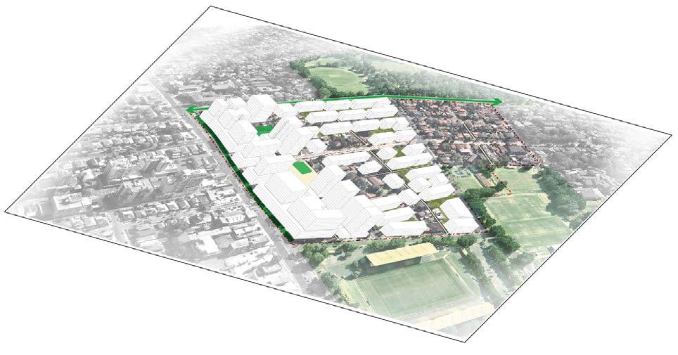
3.5 Five Dock preferred structure plan


The following are the key elements of the Structure Plan which syntheses the urban design frameworks for Five Dock:
Key elements

1. Incorporate the strategic moves of the Five Dock Town Centre Urban Design Study.


2. Additional residential density to be located one block behind the retail high street to protect the fine grain character along Great North Road.
3. Medium density generally within 400m from the Metro station.
4. The remaining areas to remain low residential with transition in height towards the periphery of the Precinct.
5. Green spine streets along Queens Road, Great North Road, Garfield Street and Second Ave as key connection routes.


Note: The draft locations of parks and laneways is a concept only and subject to change. The method of delivery of this infrastructure is yet to be determined however it is likely that they will be required to be provided over time when the land is redeveloped, with no loss to development potential.

19 City of Canada Bay SJB Five Dock Halliday Park Five Dock Park Domremy College Timbrell Park Barnwell Golf Club Great N Rd BarnstapleRd First Ave LyonsRd FairlightSt Second Ave Garfield St Queens Rd Arlington St Kings Rd RamsayRd ParramattaRoad
PARRAMATTA RIVER
3 5 1 2 5 3 4 5 5 Harris Rd Scott Street Elizabeth St Park Road Lyons Road West RoddRd Trevanion Street Henry Street Lancelot Street Cross Street 0.44ha Key Proposed precinct boundary New pedestrian link Primary connections Pedestrian crossing Plaza Solar controls for plaza Strengthen existing cycleway from on road to dedicated Active street frontage Upgrade intersection Metro acquisition boundary Metro entry Education facility Street planting Green spine Heritage items up to 3 storey residential up to 5 Storey residential up to 7 storey residential 400m catchment
Five Dock Structure Plan Five Dock Public School Rosebank College Newcastle St West Street East Street RoddLn ServiceLn BarnstapleRd School Ln Waterview St Sutton St
3.6 Five Dock - design recommendations
Have podium respond to scale in
The following are the design recommendations specific for Five Dock to ensure that the vision of the Precinct is achieved:
Provide landscape setback in residential
Allow for permeability through blocks
20 City of Canada Bay SJB Five Dock
1. Provide landscape setback in residential zone of 5m and 8m along priority green streets.
2. Preserve tree canopy within residential zone with deep soil provided to reduce urban heat.
3. Prioritise through-site links and permeability on long urban blocks for improved connectivity.
4. Sensitive development around Five Dock School with generous setbacks
5. Respond to fine-grain of cadastral lots and create a distinctive streetscapes.
6. Shop top housing along Great North Road, maintaining fine grain with residential uses above. Activity focused on the streets as a place for community and people particularly on Great North Road.
7. Sensitive transition of scale and height to areas with no change/heritage items.
8. Protect solar amenity to existing and future open spaces, especially the upgraded Fred Kelly Place.
Focus activity on the street
9. Amalgamation of lots for developments over 3 storeys with minimum lot sizes of 1,800m².
zone
edges of conservation area
3.7 Five Dock potential built form massing
Built form testing of the Structure Plan ensures that the design recommendations are achievable and enables proposed future populations to be calculated:
Note: This diagram is a general concept only and is not intended to specify development potential or open space associated with any specific site.

21 City of Canada Bay SJB Five Dock
Queens Road Garfield Street Second Ave Newcastle Street Kings Road Lyons Road West Great North Road Lyons Road Rodd Road Barnstaple Road HarrisRoad Park Road Waterview St Sutton St Coronation Ave Trevanion St Fairlight St First Avenue RamsayRoad GreatNorthRoad ScottStreet ElizabethStreet East Street West Street CrossStreet Kings Road Henry Street Five Dock Park Five Dock Public School Domremy College Parramatta River ParramattaRoad ArlingtonRoad Rosebank College Key Precinct boundary Metro site up to 7 storeys up to 5 storeys up to 4 storeys
houses
Multi-dwellings/terrace
Illustrative streetscape - Great North Road looking south

22 City of Canada Bay SJB Five Dock
New Civic Plaza Extension
street to slow vehicles
Street Parking + Tree Planting
Fred Kelly Place
Elevated
5-7 storey setbacks above 4 storey street wall
5-7 storey setbacks above 4 storey street wall Expand
existing green edge
The civic heart of Five Dock is the high street on Great North Road adjacent to the new Metro station and civic plaza, below is an illustrative sketch of the public domain:
3.8 Open space, public domain and community framework plan


Key moves
1. Great North Road, Queens Road, Garfield Street and Second Avenue are green spine streets consistent with Sydney metropolitan Green Grid network

2. Connect key open spaces with direct green cycle routes and pedestrian friendly streets to create a green network
3. Expand greening of Great North Road aligned with the Five Dock Town Centre Urban Design Study recommendations
4. Street planting along streets which have been identified with low tree canopy cover
5. Extension of the existing civic plaza (Fred Kelly Place) to the east aligned to Five Dock Town Centre Urban Design Study recommendations
6. Potential to use Five Dock Public School for weekend markets and public events (subject to approval).


7. Potential location for a new community facility, Five Dock will need 1,256m2 by 2036 of new multi-purpose community centre as stated by the CCB’s Social Infrastructure Community Strategy (CRED 2019)
Pedestrian crossing/ pedestrian area Metro site 400m catchment from open space
Heritage street trees Education facility within the study area
Potential location for multipurpose community center
23 City of Canada Bay SJB Five Dock
Halliday Park Five Dock Park Domremy College Five Dock Public School Timbrell Park Barnwell Golf Club Great N Rd BarnstapleRd First Ave LyonsRd FairlightSt Second Ave Garfield St Queens Rd Arlington St Kings Rd RamsayRd ParramattaRoad PARRAMATTA RIVER Harris Rd Scott Street Elizabeth St Park Road Lyons Road West RoddRd Trevanion Street Henry Street Lancelot Street Cross Street West Street 0.31ha
Precinct
New
Cycleway
Green
Tree
cover to be
Key
boundary Metro site
pedestrian link
network
spine Major vehicular road
canopy
increased
tree canopy cover over 40%
Established street
Civic space / plaza
Fred Kelly Place
Waterview Street Newcastle St East Street 400m 1 1 1 2 3 4 5 6 7 RoddLn ServiceLn BarnstapleRd Waterview St Sutton St
Five Dock open space and public domain framework
Rosebank College
3.9 Movement and access framework plan
Key moves
1. Future Transport Strategy 2056 classification to be used to delineate different streets to perform different functions (see definitions on page 24)
2. Great North Road to be developed as ‘Vibrant street’ this is pedestrian friendly and aligned with the Five Dock Town Centre Urban Design Study recommendations
3. Improved crossing of Great North Road connecting the east and west portion of the Fred Kelly Place made by paving and elevated street to focus on pedestrian amenity
4. Main vehicular movement to be redirected along the periphery of the precinct (Harris Road and Lyons Road)
5. All major and minor local roads intersections with Great N Road to be developed as ‘Place for People’
6. First Avenue as a calm street with a raised bus only or shared zone street to simplify the intersection and opportunity to create a new public open space, highlighting historic buildings and offering ‘spill-out’ spaces
7. Through-site links to provide safe fine grain pedestrian routes connecting residential areas to civic plaza, Metro station and retail street.
8. New improved pedestrian crossing at the intersection of Rodd Road and Great North Road
9. Establish fine grain pedestrian friendly lanes to connect residential to civic plaza
24 City of Canada Bay SJB Five Dock
Halliday Park Five Dock Park Domremy College Five Dock Public School Timbrell Park Barnwell Golf Club Great N Rd BarnstapleRd RoddLn ServiceLn First Ave LyonsRd FairlightSt Second Ave Garfield St Queens Rd Arlington St Kings Rd RamsayRd GreatWesternHwy PARRAMATTA RIVER Harris Rd Scott Street Elizabeth St Park Road Lyons Road West RoddRd Trevanion Street Sutton st Waterview St Henry Street Lancelot Street Cross Street
Rosebank College Key Precinct boundary Movement corridor Vibrant street Place for people Local street (major) Local street (minor) Education facility 5 minute walking catchment from Metro 10 minute walking catchment from Metro Crossing to be improved Gateway crossing 400m catchment New pedestrian link West Street Newcastle St East Street
Five Dock movement and access framework - vehicular
Priority streets - recommendations
A. Places for People (Great North Road)


Create a pedestrian environment by expanding footpath upgrades from Lyons Road West to Queens Road (through dedication and kerb alignment) to allow for outdoor dining/seating and deep soil planting for mature street trees. Expand calm street with paving treatment
· New tree street planting in between parking bays to increase shading


Allow opportunities for easy pedestrian crossing along the street
B. Transition Street (Queens Street)
Street to provide interface between the vision of the PRCUTS south of Queens Road and the medium scale development north of the street
· Add dedicated two-way cycle lane to southern side of the street and increase shading through street planting along the verge to improve pedestrian and cycling experience
Upgrade on-street carparking on southern side to allow for pockets of deep soil planting in between parking bays
C. Green Street / Local Street (Garfield Street)

Add dedicated two-way cycle lane to northern side of the street and increase shading through street planting along the verge to improve pedestrian and cycling experience
· Upgrade on-street carparking on southern side to allow for pockets of deep soil planting in between parking bays

Generous street setbacks for deep soil planting on private lots

25 City of Canada Bay SJB Five Dock 2m 9m 2m 3m 3m 3.5m 3.5m 24m 4m 3m 2m 7m 7m 3m
Built Form 1.5m 1.5m 7m 2.5m 2.5m 8m 20m 12m 4m 4m 8m 1m 1m 1.5m 1.5m Setback Setback Street Reserve Residential Lot Residential Lot Carriageway 2 x Traffic Lanes Property boundary Property boundary 2 Cycle Carparking & Planting Verge Path Path Verge Footpath & Verge Footpath & Verge Built Form
Street Reserve Carriageway 1 x Traffic Lane Property boundary Property boundary 1 Traffic Lane Verge Built Form Built Form Pedestrian zone Pedestrian zone Seating Seating Footpath Seating Footpath 2.5m 1.5m 7m 2.5m 2.5m 2.5m 1.5m 5m 20m 12m 4m 4m 5m Street Reserve Carriageway 2 x Traffic Lanes Residential Lot Residential Lot Pedestrian zone Pedestrian zone Cycling Path Verge Verge Path Street Setback Built Form Carparking & Planting Street Setback Built Form Property boundary Property boundary A B C
Active and cycle framework plan
Key moves
1. New improved pedestrian crossing at the intersection of Rodd Road and Great North Road
2. Establish fine grain pedestrian friendly lanes to connect residential to civic plaza

3. New on road cycleway along Great North Road finishing at the civic plaza with an end of trip facility to promote active transport to reach Metro station from residential areas
4. Improvements of existing on-road cycleway within the boundary to dedicated cycleways which connect and are consistent with the proposed Concord cycleway network.
Key
Precinct boundary
Metro site
Existing cycleway
LSPS future on road cycle route
PRCUTS future on road cycle route
Upgrade to dedicated cycle lanes
New pedestrian link
Pedestrian priority street
Education facility
Fred Kelly Place extension
5 minute walking catchment from Metro
10 minute walking catchment from Metro
New pedestrian crossing
End of trip facility
Rosebank College
26 City of Canada Bay SJB Five Dock Halliday Park Five Dock Park Domremy College Five Dock
School Timbrell Park Barnwell
Great N Rd BarnstapleRd First Ave LyonsRd FairlightSt Second Ave Garfield St Queens Rd Arlington St Kings Rd RamsayRd GreatWesternHwy PARRAMATTA RIVER Harris Rd Scott Street Park Road Lyons Road West RoddRd Trevanion Street Henry Street Lancelot Street Cross Street West Street
Public
Golf Club
Revitalised alleyway at Evans Alley Bridge, Denver
Five Dock movement and access framework - active and cycle
400m RoddLn ServiceLn Sutton st Waterview St Elizabeth St
3.10 Land use and activity framework plan


Key moves
1. Upgrade and extension of Fred Kelly Place as an important civic plaza for the Town Centre
2. Activity hubs focused around the existing civic plaza and new extension where the Metro station is proposed
3. More activity opportunities to extend along Great North Road from Lyons Road and Queens Road
4. Passive recreation activities could be located along the laneways where a more calm environment is created by the reduced vehicular movement. Opportunities for laneway activation and public activities (such as popup events).
Key Precinct boundary


Metro site
Mixed use
Residential density transition
Active street
Active frontage
Secondary frontage activation


Heritage
New open space

27 City of Canada Bay SJB Five Dock
Halliday Park Five Dock Park Domremy College Five Dock
School Timbrell Park Barnwell
Club Great N Rd BarnstapleRd First Ave LyonsRd FairlightSt Second Ave Garfield St Queens Rd Arlington St Kings Rd RamsayRd GreatWesternHwy PARRAMATTA RIVER Harris Rd Scott Street School Ln Park Road Lyons Road West RoddRd Trevanion Street Henry Street Lancelot Street Cross Street West Street East Street
Public
Golf
Rosebank College 400m RoddLn ServiceLn BarnstapleRd Waterview St Sutton St
Five Dock land use and activity framework
3.11 Built form and heritage framework plan
Key moves
1. Built form to provide transition from low scale, low density residential toward the higher densities along Great North Road
2. Heights concentrated along Great North Read with up to 7 storeys mixed use developments. Heights transitioning down to 4 to 5 storey residential apartment buildings and 1 to 3 terrace houses and dual occupancy typologies
3. Interface between mixed use and residential densities to be approached through the provision of lanes and through site links.
Key
Precinct boundary
Mixed use
Residential density transition
Residential and mixed use interface
Heritage
Open space
New pedestrian link
28 City of Canada Bay SJB Five Dock
Halliday Park Five Dock Park Domremy College Five Dock Public School Timbrell Park Barnwell Golf Club Great N Rd BarnstapleRd First Ave LyonsRd FairlightSt Second Ave Garfield St Queens Rd Arlington St Kings Rd RamsayRd GreatWesternHwy PARRAMATTA RIVER Harris Rd Scott Street Park Road Lyons Road West RoddRd Trevanion Street Henry Street Newcastle St Lancelot Street Cross Street West Street School Ln
Rosebank College 400m 2 1 3 RoddLn ServiceLn Sutton st Waterview St Elizabeth St
Five Dock built form, heritage and development framework
Building heights
Setbacks
Key moves
1. Heights reflecting Five Dock Town Centre Urban Design Study recommendations with maximum heights of 7 storeys with 4 storey street walls along Great North Road
2. Up to 5 storey height for residential development for areas east and west of Great N Road
3. Up to 4 storeys for the blocks bounded by Scott Street, Cross Street, Lyons Road, Queens Road, Fairlight Street and Trevanion Street as a transition area to surrounding existing low density areas.
4. No change for the blocks between Scott St and Harris Road
Key moves
1. Setbacks to respond to and reflect the structure plan and built form typology and building heights as well as the Five Dock Town Centre study recommendations
2. 0m setback along Great North Road block to encourage street activation along the high street
3. Green spine streets delivered through 8m street setback to promote increased tree canopy and landscaped interfaces with the street
4. 5m setback along areas earmarked for residential redevelopment
5. 3m setback along laneways one block from Great North Road to allow for pedestrian connectivity
6. 1m setback along all existing laneways
7. Retain existing setback controls for areas unchanged.
29 City of Canada Bay SJB Five Dock
Halliday Park Five Dock Park Domremy College Five Dock Public School Timbrell Park Barnwell Golf Club Great N Rd BarnstapleRd First Ave LyonsRd FairlightSt Second Ave Garfield St Queens Rd Arlington St Kings Rd RamsayRd GreatWesternHwy PARRAMATTA RIVER Harris Rd Scott Street Elizabeth St Park Road Lyons Road West RoddRd RoddRd Trevanion Street Henry Street Lancelot Street Cross Street West Street East Street East Street Halliday Park Five Dock Park Domremy College Five Dock Public School Timbrell Park Barnwell Golf Club Great N Rd BarnstapleRd First Ave FairlightSt Second Ave Garfield St Queens Rd Arlington St Kings Rd RamsayRd GreatWesternHwy PARRAMATTA RIVER Harris Rd Scott Street Park Road Lyons Road West Henry Street Newcastle St Lancelot Street Cross Street West Street
Key Precinct boundary Metro site up to 2 storeys up to 3 storeys up to 4 storeys up to 5 storeys up to 7 storeys X Storey height Key Precinct boundary Metro site No street setback 1m street setback 3m street setback 5m street setback 8m street setback
Sutton Street Waterview St Five Dock recommended building heights Five Dock recommended setbacks Rosebank College Rosebank College 400m 400m 3 2 4 4 5 7 RoddLn RoddLn ServiceLn ServiceLn Waterview St Sutton St Trevanion Street LyonsRd
Concord 4
4.1 Challenges
The key findings from site analysis and distillation from the baseline review have been summarised into the following key points:
1. The vision identified in PRCUTS needs to be implemented into the structure plan however it is split across two LGAs - Canada Bay and Burwood - and could limit cohesive delivery of the vision
2. Precinct is bounded between major road traffic barriers in particular Parramatta Road acts a north-south barrier especially with active transport and pedestrian connectivity.
3. Identified problematic intersections
4. Existing new developments have poor interface with heritage items and conservation areas.
Key Precinct boundary
400m catchment
PRCUTS boundary
Busy traffic road
Major traffic road (barrier)
Dead-end road
Pedestrian paths
Character areas under investigation
Existing medium density
Education facility
Heritage item
Dangerous crossing
Open space
Golf course
31 City of Canada Bay SJB
St
Park Concord Oval Queen
Burwood Park Wangal Park Barnwell Golf Club GippsSt CraneSt StanleySt LyonsRd Queens Rd Parramatta Rd Burwood Rd Burwood Rd Loftus St Lansdowne St Broughton St BroughtonSt David St DavidSt Burton St Neich Parade
Lukes
Elizabeth Park
PARRAMATTA RIVER
4 3 1 2 3 3 5
400m Concord Primary
Concord
Key challenges in Concord
School
High School
1.4 Opportunities map
Opportunities
1. Opportunity for increased mixed use whilst still retaining enterprise corridor uses on the ground level.
Maintain
1. Maintain the incredible landscape setting of the area and the connection with local parks and the foreshore area.
2. Areas within 400m of a significant Metro have the potential for density uplift.
2. Maintain an area of 1-2 storey detached dwellings that interfaces with the school and strengthen the pedestrian friendly low scale streetscape.
3. Creating new laneways and through-site links to improve the permeability of long blocks
4. Upgrade streets with tree planting, better pedestrian crossings and calming of traffic area areas of high pedestrian volume.
Enhance
5. Opportunity for Gipps Street and Broughton Street to become green spines connecting to open space
6. Potential for additional new pocket parks/plazas.
3. Enhance the amenity around the local schools and integrate spaces for the community to linger before and after drop-off times.
7. Clear vision on how developments interface with Parramatta Road.
8. Burton Street upgraded to local centre with active street frontage.
4. Enhance the medical uses in this area with other related industries and create a connection to the community facility
5. Upgrade Concord Oval as a truly vibrant community hub with co-location of uses and facilities to revitalise key nodes and create hubs of activity with good connections to key open spaces/facilities.
9. Improve gateway entry into precinct at Burwood Road and to provide an additional pedestrian crossing.
10. Improve pedestrian crossing across Parramatta Road to strengthen the significant transport interchange with Burwood Station (located 1.5km south)
Change
6. Redevelop the existing single storey community centre building and co-locate with other community facilities/ uses and improve the streetscaping and connectivity
7. Increase density with infill development especially in areas located close to the new Metro. Ensure that new quality developments integrate with the existing tree canopy, considers the landscape setback and unlocks pedestrian connectivity
entry
8. Breakdown pedestrian barriers created by Parramatta Road, allow for more opportunities to safely cross the arterial road towards Burwood Town Centre without further congestion.
Metro above ground infrastructure
9. Improve walkability in the area with additional through site links.
New link
10. Facilitate a range of building heights and densities across the precinct in accordance with PRCUTS.

Strengthen existing cycleway
Proposed cycleway Active street frontage
Co-located community facilities Street planting Green spine
Opportunity to improve pedestrian crossings
Landscape gateway
Open space
Opportunity for mixed use
Opportunity to introduce new open space
Key opportunities in Concord
32 City of Canada Bay SJB Concord 7 Concord/Burwood North SJB Introduction
St Lukes Park Concord Oval Queen Elizabeth Park Burwood Park GippsSt CraneSt StanleySt LyonsRd Queen Rd Parramatta Rd Burwood Rd Burwood Rd Loftus St Lansdowne St Lansdowne St Burton St Neich Parade PARRAMATTA RIVER Key opportunities in Concord/Burwood North 400m Concord Primary School Concord High School DRAFT
Wangal Park Barnwell Golf Club DavidSt Broughton St BroughtonSt Queens Rd Key Precinct
Metro
boundary
Connections
Education
Opportunity for medium density
facility
2 3 4 6 7 7 1 2 8 5 6 9 10
4.3 Vision

Concord is a precinct located within the suburb of Concord and is strategically positioned to support Burwood town centre to the south and the predominantly residential population to the north.

The precinct will be an attractive destination with high quality buildings, retail opportunities, community facilities and public spaces that serve the wider community who use the Metro Station. The local area has access to many significant amenities such as local community facilities, schools and the abundance of public open space.
Concord will be a vibrant mixed use centre with height focused along Parramatta Road, transitioning to the low density residential areas to the north. The built form will be sensitive to it’s context, with an appropriate interface to the noise and pollution created by Parramatta Road. Pocket parks, activated through site links and a station plaza will be screened from the main road and the amenity of the local streets will be protected by the built form and trees.
Burton Street, Burwood Road and the laneways that intersect them will be ‘places for people.’ The community will be able to enjoy the intimate scale of a retail street with on street dining and graband-go opportunities for future commuters.
BUILT FORM
33 City of Canada Bay SJB Concord CONCORD ENABLING ACTIVE TRANSPORT CREATE STREET ACTIVATION VISION OF PRCUTS DOMINANCE OF PARRAMATTA RD ST LUKES PARK CINTRA PARK HOCKEY NETBALL CONCORD OVAL RUGBY UNION SOCCER 20,000 CAPACITY 1987 RUGBY WORLD CUP HERITAGE WANGAL INDIGENOUS PEOPLE AFL CONCORD GIANTS CRICKET LITTLE ATHLETICS WATERWAY REHABILITATION RECREATION FACILITY NRL WEST TIGERS NEW COMMUNITY FACILITIES CBD ON RIDGE VIEWS 3,600 MEMBERS FUTURE CONNECTION TO NEW AIRPORT BADGERYS CREEK PARRAMATTA CBD OLYMPIC PARK DENSITY NEAR STATION RELIEVE VEHICULAR PRESSURE & CONGESTION CONNECTIVITY CREATING A CENTRE
PRECINCT
SPORTING
CHARACTER & IDENTITY
THE LOCAL SPORTING HEART BETTER CONNECTIVITY NORTH & SOUTH OVER PARRAMATTA RD
YOUTH ENGAGEMENT CONNECTION TO PUBLIC SPACES CONVICT HISTORY LARGE FLOORPLATE RETAIL ALONG PARRAMATTA RD M
PUBLIC TRANSPORT
Vision objectives
Concord is known as the ‘Parklands Suburb’ of the Inner West, and offers a unique opportunity to be the local sporting and physical health precinct for the LGA. Reinforced by the new metro, Concord can offer a supporting role to Sydney Olympic Park’s facilities by hosting a variety of sporting events, building upon the existing amenities provided in the area and reinforced as a centre with connectivity to the greater Sydney metropolitan area.
The PRCUTS incorporates Concord within the BurwoodConcord Precinct and identifies transformation areas to create a significant transport interchange with Burwood Rail Station (approximately 1.5km south) and improving active transport connections to regional recreation and open space facilities, reinforcing the vision of an active and vibrant sporting precinct.
Not only will Concord precinct continue to service the area with regional sporting facilities and attract exciting and new sporting events, other significant employment opportunities such as sports and health related services (such as Concord Private Hospital and Orthosports Physiotherapy and Sports Injuries Centre) will also be enhanced and expanded. This precinct provides the opportunity to locate a range of housing typologies within close proximity to the significant recreational amenities.
The following are a number of high-level objectives that have informed the vision for the future of Concord area. These objectives have been taken from the vision statement. The principles that underpin the delivery of the vision objectives are explored in detail over the following pages.
1. Ensure public domain around public transport facilities are attractive, pedestrian friendly and offer a convenient transfer between different modes of transport and better pedestrian connections.

2. Breakdown pedestrian barriers created by Parramatta Road, allow for more opportunities to safely cross the arterial road towards Burwood Town Centre without further congestion.
3. Upgrade Concord Oval as a truly vibrant community hub with co-location of uses and facilities to revitalise key nodes and create hubs of activity with good connections to key open spaces/facilities.


4. Allow for shared zones and break out spaces around transport infrastructure. Create spill out spaces for events which are activated and pedestrian friendly.


5. Create ‘places for people’ ensuring retail along Parramatta Road is suitable with its location and purpose with finer grain retail and food offering along Burton Street.

6. Maximise activation of the ground plane. Support greater development intensity and a broader mix of land uses within close proximity to the station and areas of high pedestrian footfall.
7. Increase the variety of housing and building types on offer by encouraging more low-rise, and medium density urban typologies. Development should respond to queues from the natural environment.

8. Increase building heights around the Metro site to improve legibility and create a landmark/gateway presence to the precinct. Towers should be of appropriate scale to the area with good street interface and setbacks.

34 City of Canada Bay SJB Concord
Summary desired sub-precinct character
Concord has been divided into six (6) separate local character sub-precincts based on the feedback from the community, the varied urban form that observed on site, and alignment with strategic changes in the local area. This is a snapshot taken from the local character statement.
Parramatta direct interface
The Parramatta Road sub-precinct will be transformed from the one to two storey shop top housing with commercial/retail uses into a high density mixed use precinct. Building heights will range from 3- 17 storeys. The pedestrian amenity along the street will be improved with design and interface strategies to mitigate the heavy vehicular traffic and congestion of Parramatta Road. New spaces for public domain will be made available on the northern edge of the core, shielded from the noise of the main road. Streets and lane-ways will be activated by retail and the integrated transport hub will add to the destination-al nature of this precinct. The future of this area will be consistent with the vision of the PRCUTS and to improve the public domain and streetscaping.
Infill area residential (south of Gipps Street)
Infill development should maintain the exist character and in particular the heritage trees on Landsdowne Street. More broadly, the heritage items throughout the area will be protected and augmented through public realm upgrades, including tree planting, upgrades to verges to protect existing trees and new cycle paths. This space will operate as a transition buffer from higher densities focussed along Parramatta Road to low density residential in the northern part of the study area and broader Concord. Development of new buildings up to five (5) storeys will be mindful of the existing condition, with change evolving in a manner that continues to complement the existing conditions.
Infill area residential (north of Gipps Street)
Sub-precinct five (5) will maintain it’s existing residential character with a maximum five (5) storey building height consistent with PRUCTS. Development of new buildings up to five (5) storeys will be mindful of the existing condition, with change evolving in a manner that continues to complement the existing character. Existing uses other than residential can remain.
This precinct operates as a primary interface between St Luke Park and the wider precinct, new developments and additions to this sub-precinct should provide view-lines or through-site links from Burwood Road to the public open space.
High density residential and plazas
Infill development that is sensitive to the surrounding built form will continue to diversify housing options in Concord. Building heights will range from 12-24 storeys with the he future of this area to be consistent with the vision of the PRCUTS. Interfaces with streets and public spaces will add to the vibrancy of the local area with activation and passive surveillance from local residential dwellings and ground floor retail. The proximity to the station will make this a great space for urban commuters to live with public transport options, diverse housing choices and the amenity of local parks right at hand.
Low density residential (north of Gipps Street)
This sub-precinct will accommodate up to two (2) storeys, (or 9m/3 storeys) where multi-dwelling housing (terraces) are provided in accordance with LEP, in a manner that is complementary to the existing dwelling typology of 1-2 storeys stand alone dwellings. There are key opportunities to enhance heritage items with the low density infill development that is of a sensitive scale to the surrounding context and improve the streetscape. Tree planting and cycle paths will add to the amenity of the local area.
Stanley Street interfaces with the local primary school and should be a particular focus for upgrades, including improvements to road crossing, street trees, bench seats and bicycle lanes.
6
St Luke’s Anglican Church sub-precinct
This local character sub-precinct is a residential neighbourhood anchored by St Luke’s Anglican Church, which is a mix of Gothic/Romanesque style church built in 1861. The heritage nature of the building should be maintained, while opportunities to enhance the environs with better public interface through improved streetscaping should be encouraged.
Medium density development will be permitted ranging from five (5) storeys up to twelve (12) with building to boundary and active frontages encouraged on the southern edge (Burton Street).
35 City of Canada Bay SJB Concord
Burwood Road StanleyStreet Loftus Street Broughton Street Parramatta Road Burton Road GippsStreet 1 2 3 4 6 Character Precincts in Concord 5
1
2
3 4
5
Street DavidSt David St
Lansdowne
4.4


The following are the key elements of the Structure Plan which synthesizes the urban design frameworks for Concord:
Key elements
1. Incorporate the strategic moves of the PRCUTS along Parramatta Road. Strengthen the local centre with mixed use development along Parramatta Road
2. High residential density within 200m of the station and along the park edge
3. Low rise residential density concentration along Broughton and Gipps Streets within 400m from the Metro Station and to frame St Lukes Park
4. The remaining areas to remain a three storey residential area and transition in height towards Queen Elizabeth Park, the periphery of the Precinct and the earmarked Character Area in the Local Housing Strategy
5. Provide new streets for better connections from the station to the upgraded community precinct and St Lukes Park
6. Provide an open space/plaza within the Metro development
7. Unlock permeability throughout the Precinct with key new connections.
*Note: The draft locations of parks and laneways is a concept only and subject to change. The method of delivery of this infrastructure is yet to be determined however it is likely that they will be required to be provided over time when the land is redeveloped, with no loss to development potential.

36 City of Canada Bay SJB
Key Proposed precinct boundary Metro site New pedestrian link Primary connections Plaza Open space Strengthen cycleway to dedicated lane Proposed cycleway Active street frontage Heritage Metro site Improved streetscape Character Area Street planting Green spine Up to 3 Storeys residential Up to 5 Storeys residential Up to 24 Storeys residential Up t 12 Storeys mixed use
GippsSt CraneSt StanleySt Queens Road Parramatta Rd Burwood Rd Burwood Road Loftus Street Lansdowne Street Burton Street Neich Parade Broughton Street Broughton Street David St DavidSt 0.2ha 0.2ha St Lukes Park Concord Oval Queen Elizabeth Park 3 5 6 1 2 2 3 3 4 7 Concord Structure Plan Concord Primary School Concord High School 400m
Concord preferred structure plan
4.5 Concord - Design recommendations
The following are the design recommendations specific for Concord to ensure that the vision of the Precinct is achieved:
Respond to height and scale of conservation area
Have podium respond to scale in edges of conservation area
Provide landscape setback in residential zone
Allow for permeability through blocks
1. Ensure sensitive interface with heritage item is provided through setbacks and height transition.
2. Provide landscape setback in residential zone of 3m and 8m along priority green streets.
40m seperation for towers greater than 25 stories
3. Preserve tree canopy within residential zone with deep soil provided to reduce urban heat.
Above Podium Setback
4. Prioritise through-site links and permeability on long urban blocks for improved connectivity.
5. Passive surveillance to St Luke’s Park. Opportunity to remove back fences and provide laneway to provide street frontage to park.
Allow for interim screened above ground parking that could later be retrofitted into commercial use
Amalgamation of lots for developments over 3 storeys with minimum lot sizes of 1,800m². Minimum lot size of 1,800m² with podium setback above 4 storeys to provide a continuous street wall and reduce scale from street level.
Building separation between towers to be ADG compliant at a minimum.
Prioritise height at key intersections and nodes as gateway sites.
Protect solar amenity to existing and future open spaces and plazas.
Parking preferably underground, where not possible, above ground carparking should be sleeved with active uses or green walls.
37 City of Canada Bay SJB Concord
*
4.6 Concord potential built form massing
Built form testing of the Structure Plan ensures that the design recommendations are achievable and enables proposed future populations to be calculated:
Note: This diagram is a general concept only and is not intended to specify development potential or open space associated with any specific site.
Proposed open space
Multi-dwellings/terrace houses

38 City of Canada Bay SJB Concord
ParramattaRoad Concord
Broughton
StanleyStreet
Key Precinct
Metro
Plaza 15+
up
up
Oval St Lukes Oval
Street Goddard Park Queen Elizabeth Park
GippsStreet BurtonStreet BurwoodRoad LoftusStreet BurwoodRoad David St
boundary
site
storeys
to 14 storeys
to 5 storeys
Illustrative streetscape - Burwood Road looking south Burwood Road is a key vibrant street which connects north to Parramatta River and south to Burwood Town Centre, it is also adjacent to the new Metro station, below is an illustrative sketch of the public domain:

39 City of Canada Bay SJB Concord
Cafe + Activity New Metro Civic Plaza
Street Parking + Tree Planting
Street Parking + Tree Planting
4.7 Open space, public domain and community framework plan


Key moves
1. CCB’s Social Infrastructure (Open Space and Recreation) Strategy and Action Plan (CRED 2019) indicates that there is a sufficient provision of open space within this Precinct.
2. Gipps and Broughton Streets green spine streets consistent with the vision of the metropolitan Sydney Green Grid network
3. Connection of the key open spaces of Queen Elizabeth Park and St Lukes Park along Gipps Street through improved pedestrian and cycle experience
4. Vision of the PRCUTS along Parramatta Road reducing the dominance of vehicular traffic to a multi-modal street with an integrated bus rapid lane and clear access and connections to the Metro station
5. Improve pedestrian and cycle mobility north to south especially crossing Parramatta Road. This includes street level intersections, pedestrian bridges and underground connections through the Metro station. These links should connect with the broader regional cycle network and green streets
6. Additional tree planting to reduce heat island effect and provide 40% tree canopy across the entire precinct.
Character


40 City of Canada Bay SJB 4
GippsSt CraneSt StanleySt Queens Road Parramatta Rd Burwood Rd Burwood Road Loftus Street Lansdowne Street Burton Street DavidStreet Neich Parade Broughton Street Broughton Street Burwood Road 0.2ha 0.2ha St
Concord Oval
Lukes Park
Key Precinct boundary New pedestrian link Cycleway network Green spine Major vehicular road Tree canopy cover to be increased
street tree canopy cover over 40% Metro site Metro acquisition boundary 400m catchment from open space
street trees
Queen Elizabeth Park
Established
Heritage
area
investigation
under
Concord open space and public domain framework
400m
Concord Primary School Concord High School
4.8 Movement and access framework plan
Key moves
1. Future Transport Strategy 2056 classification to be used to delineate different streets to perform different functions. Promote clear types of functions and street hierarchy to prioritise each street type (see definitions on page 24)
2. Main vehicular movements focused on the periphery along Parramatta Road and Broughton Street. This allows for local movements within the precinct.
3. Improve pedestrian connections from metro to Concord Primary and High School with streetscape upgrades and footpath widening
4. Integration of the PRCUTS vision to provide bus rapid transport lanes along Parramatta Road to further promote public transport movement with servicing laneways away from pedestrian focused streets.
5. Promote Burwood Road as vibrant street thus redirecting vehicular movement along Broughton Street to allow for activation and pedestrian friendly environment.
6. Mid-block through site links to break down urban blocks, promote porosity, connectivity and safe routes for pedestrians.
7. Opportunities to increase pedestrian and cycle accessibility and safety through streetscape improvements along Parramatta Road.
8. Connect open spaces through a green spine and cycleway network along Gipps Street.
9. Provide on road cycle way along Burton Street up to the civic plaza with a end of trip facility to promote active transport to the Metro station.
10. Provide new lane access for commercial uses.


41 City of Canada Bay SJB Concord DavidStreet
GippsSt CraneSt StanleySt Queens Road Parramatta Rd Burwood Rd Burwood Road Loftus Street Lansdowne Street Burton Street Neich Parade Broughton Street Broughton Street Burwood Road 0.2ha 0.2ha St Lukes Park Concord Oval Queen Elizabeth Park
Concord
framework - vehicular and active Key Precinct boundary Metro site Movement corridor Vibrant street Place for people Local street (major) Local street (minor) Existing cycleway LSPS future on road cycle route PRCUTS future on road cycle route 5 minute walking catchment from Metro 10 minute walking catchment from Metro Crossing to be improved Gateway crossing New pedestrian link Proposed open space End of trip facility 400m Concord Primary School Concord
movement and access
High School
Priority streets - recommendations
A. Movement Corridor (Parramatta Road)
Align with the vision of PRCUTS, converting one lane into a bus rapid transit lane with weather protection bus shelters
· Expand footpath through setback controls for potential outdoor dining


· Generous street setbacks to allow deep soil planting to achieve optimum tree outcomes


Places for People (Burton Street & Neichs Lane)
Realign Neichs Lane to allow seamless transition into the Metro Civic Plaza from the Metro Entry and increase outdoor dining and planting
· Creation of Metro Civic Plaza as a community space, potential for seating, popup markets and outdoor cinema etc.
· Add dedicated two-way cycle lane to southern side of Burton Street and increase shading through street planting
42 City of Canada Bay SJB Concord
6m 6m 3.5m 3.5m 2.5m 2.5m 3m 3m 6m 19m 24m 6m M M Footpath & Outdoor Dining Bus Stop & Planting Footpath Dining Carriageway Street Reserve Built Form Built Form 1 x Bus Lane 1 x Bus Lane Bus Stop & Planting Footpath & Outdoor Dining 2 x Traffic Lanes 2 x Traffic Lanes Mixed Use Lot Mixed Use Lot Property Boundary Property Boundary M 5m 5m 1m 11.5m 2m 6.5m 2.5m 2m 3m 5m 2.5m 2m 20m 3.5m 3m Dining Metro Civic Plaza Carriageway Built Form Walkway Public Community Space Street Reserve Planting Planting Planting Burton Street Property Boundary Property Boundary Property Boundary Residential Lot x Bike Lanes 2 Traffic Lane Carpark Planting Footpath Footpath & Planting Street Setback Built Form Mixed Use Lot Metro Civic Plaza Street Setback A B
4.9 Land use and activity framework plan

Key moves
1. Street activation through ground level fine grain retail and non-residential uses focused along areas where higher levels of pedestrian traffic is anticipated around the mixed use areas between Parramatta Road and Burton Street
2. Improved connections of Burwood Road south and north of Parramatta Road as a continuous retail spine, strengthening this street as a vibrant corridor
3. Active frontage and retail to face Parramatta Road, service laneway to remove servicing off Parramatta Road. Opportunity to realign laneway not to conflict with the seemless connection of the new Metro station entrance.
Precinct boundary


Metro site
Mixed use
High density residential
Residential density transition
Active street
Active frontage
New open space
Heritage item
43 City of Canada Bay SJB Concord
GippsStreet CraneSt StanleySt Queens Road Parramatta Rd Burwood Rd Burwood Road Loftus Street Lansdowne Street Burton Street Neich Parade Broughton Street Broughton Street Burwood Road 0.2ha 0.2ha St Lukes Park Concord Oval Queen Elizabeth Park Burwood Park
Key
Concord land use and activity framework 400m Concord Primary School Concord High School DavidStreet
4.10 Built form and heritage framework plan
Key moves
1. Built form transition from low scale, low density residential north of Stanley Street to taller development along Parramatta Road in line with the PRCUTS vision of heights up to 24 storeys.
2. Built form to face new pocket parks and civic plazas to create active frontages and provide passive surveillance
3. Ensure that solar amenity is maintained to proposed and existing public domain
4. Residential developments from Stanley Street to Burton Street. Mixed use along Parramatta Road with commercial uses in the podium and residential above
5. Lot amalgamation with a minimum 1,800m² size to facilitate larger developments and height to ensure proper deep soil planting and improved public domain interface.
Key
Residential
Heritage
Open space
New pedestrian link
44 City of Canada Bay SJB Concord
GippsSt CraneSt StanleySt Queens Road Parramatta Rd Burwood Rd Burwood Road Loftus Street Lansdowne Street Burton Street Neich Parade Broughton Street Broughton Street Burwood Road 0.2ha 0.2ha St Lukes Park Concord Oval Queen Elizabeth Park
Precinct boundary
Mixed use
Residential density transition
and mixed use interface
400m Concord Primary School Concord High School DavidStreet
Concord built form, heritage and development framework
Key moves
1. Heights reflecting PRCUTS recommendations with maximum heights of 42m (13 storeys) for the blocks between Burton Street and Parramatta Road.
2. Heights of 38m (12 storeys) for the block along Loftus Street and overlooking Concord Oval and creating an edge to the precinct
3. 4-5 storey height for residential development for all blocks between Burton Street and Gipps Street and the block between Stanley Street and Gipps Street facing St Lukes Park
4. 1-2 storeys or 9m (3 storey) for the blocks bounded by Gipps Street, Stanley Street, Burwood Road and Broughton Street as a transition to existing low density areas to the north.
Key
1. Setbacks to respond to and reflect the structure plan and built form typology and building heights as well as the PRCUTS recommendations
2. 6m setback along Parramatta Road as recommended by PRCUTS
3. Green spine delivered through 8m street setback to promote increased tree canopy and landscaped interfaces with the street
4. 3m setback along all new lanes and connections
5. 3m setback in areas with residential density uplift to promote deep soil planting to interface with the streets
6. Retain existing setback controls for areas unchanged.
45 City of Canada Bay SJB Concord
Setbacks GippsSt DavidSt CraneSt StanleySt Queens Road Parramatta Rd Burwood Rd Burwood Road Loftus Street Lansdowne Street Burton Street Neich Parade Broughton Street Broughton Street Burwood Road St Lukes Park Concord Oval Queen Elizabeth Park GippsSt CraneSt StanleySt Queens Road Parramatta Rd Burwood Rd Burwood Road Loftus Street Lansdowne Street Burton Street Neich Parade Broughton Street Broughton Street Burwood Road St Lukes Park Concord Oval Queen Elizabeth Park Key Precinct boundary Metro site up to 3 storeys up to 5 storeys 6-11 storeys 12+ storeys X Storey height Key Precinct boundary Metro site No street setback 3m street setback 4.5m street setback 6m street setback 8m street setback
Building heights
moves
Concord
building
Concord recommended setbacks 400m 400m 3 5 5 5 2 7 5 12+ 12+ DavidSt
recommended
heights


46 City of Canada Bay SJB Concord PARRAMATTARD ADA ST DALY AVE MERYLA ST COMER ST PARK RD NEICH PDE BRITANNIA AVE GRANTHAM ST SHAFTESBURY RD ARCHER ST ESHER ST LUKE AVE LUCAS RD CRANEST FINCHAVE EVELYNAVE BURWOODRD BURWOOD RD BURWOOD RD DAVIDST SALISBURYST BROUGHTONST LOFTUSST WENTWORTH RD PHILIP ST MOSELY ST SWAN AVE MASON RD ROBERTS ST COLES ST MELBOURNE ST JOHN ST PARK AVE BURTON ST MILTON ST NEW ST GIPPSST STANLEYST CRANEST ADDISONAVE PATTERSON ST ALEXANDRA ST ROWLEY ST COOPERST Precinct Boundary Frame Boundary Land Use Medium Density Residential Neighbourhood Centre Mixed Use Enterprise Corridor Infrastructure R3 B1 B4 B6 SP2 Figure 8.12: Burwood-Concord Recommended Land Uses R3 R3 R3 R3 R3 B4 B4 B4 B4 B6 B6 B1 B1 R3 R3 SP2 SP2 163 Parramatta Road Corridor | Planning and Design Guidelines PARRAMATTARD PARRAMATTA RD ADA ST DALY AVE MERYLA ST COMER ST PARK RD NEICH PDE BRITANNIA AVE GRANTHAM ST SHAFTESBURY RD ARCHER ST ESHER ST LUKE AVE LUCAS RD CHELTNHAM RD ROYCE RD WALKER ST CRANEST FINCHAVE EVELYNAVE BURWOODRD BURWOOD RD BURWOOD RD DAVIDST SALISBURYST BROUGHTONST LOFTUSST TAYLOR ST WENTWORTH RD PHILIP ST MOSELY ST SWAN AVE MASON RD ROBERTS ST COLES ST MELBOURNE ST JOHN ST PARK AVE BURTON ST MILTON ST NEW ST GIPPSST STANLEYST CRANEST ADDISONAVE PATTERSON ST ALEXANDRA ST ROWLEY ST COOPERST Precinct Boundary Frame Boundary Height of Buildings 8.5m 12m 17m 21m 24m 32m 40m 42m M P R S U W1 W2 0 Figure 8.13: Burwood-Concord Recommended Building Heights P P P P P P R M M R I I U U U U U W2 W2 R M S S R R R R S S P S S S P W1 S P P P P P P P P Parramatta Road Corridor | Planning and Design Guidelines
Land Zoning Height of Buildings
PRCUTS (reference)
North Strathfield 5
5.1 Challenges
The key findings from site analysis and distillation from the baseline review are summarised into the following key points:
1. Train line disconnects east-west precinct
2. Flooding issues limits development potential to the west
3. The creek line results in dead end roads (limits vehicular and pedestrian connectivity)
4. Heritage items scattered throughout the precinct as single lots
5. Education facilities (McDonald College and Our Lady of the Assumption Catholic Primary School) and existing medium density located in close proximity to the existing station limits the potential for new development
6. Precinct is bounded by major traffic roads which creates barriers for connectivity
7. Identified problematic intersections
8. New development to interface with heritage items (scale, transition, material and architectural language) and appropriately transition in height from the conservation areas
9. Lack of open space within the precinct
10. Lack of community centre facilities within the precinct.
Cul-de-sac
Pedestrian paths
Character areas (under investigation)
48 City of Canada Bay SJB
Bressington Park Central Park Allen St Reserve Bill Boyce Reserve Henley Park George St Queen St Concord Rd Wellbank St Shipley St Nelson Rd WesternMotorway UnderwoodRd Pomeroy St Malta St Warsaw St Lorraine St Gracemere St Beronga St CorreysAve Davidson Ave Consett St McKenzie St Hamilton St Lemnos St Key Precinct boundary
catchment
traffic
Metro site 400m
Busy traffic road Major
road (barrier)
NORTH STRATHFIELD Waratah St Brussels St Mena St Argonne St Hillier St Napier St Nelson Rd Princess Ave Allen St 1 2 3 4 5 6 6 7 7 8 7 7
Existing medium density Flood affected land Education facility Heritage item Dangerous crossing Open space
Key challenges in North Strathfield
North Strathfield
North Strathfield
5.2 Opportunities
1.4 Opportunities map
Maintain
1. Protect identified Character area with minimal changes to streetscape and nature of built form.
1. To deliver a new public open space of at least 0.2ha (+ approximately 0.1ha public domain) to address shortfall identified by CRED findings and to accommodate the growth in population


2. The local heart of the character area is to be maintained and the streetscape protected. Taller buildings should be set back from the street to allow the historic buildings to be more prominent.
2. Expand the B1 Neighbourhood centre and increase retail offerings to create an attractive local centre
3. Potential for a new landscaped gateway from Parramatta Road as a clear way-finding vehicular entrance into the precinct
Enhance
3. Existing medium/high density development, the streetscape is to be improved on the norther n end of George Street.
4. Potential for George Street south of Pomeroy Street to be transformed into a pedestrian priority street
5. Potential for Pomeroy Street to be transformed into a green spine with active transport links
6. Better pedestrian connections along Wellbank Street to existing shops along Concord Road from station
4. Expansion of the Bakehouse Quarter to Parramatta Road to improve the interface into the precinct and increase retail offerings to create an attractive local centre.
7. New street and new pedestrian connection over the creek corridor at Lorraine Street to connect to open space. Expand the existing pedestrian connection along the Creek towards Bakehouse Quarter
5. Improve pedestrian connection over the creek corridor at Lorraine Street to connect to open space. Expand the existing pedestrian connection along the Creek towards Bakehouse Quarter
8. Identified areas which can support medium density sites
6. Expand open space provision with a playground on both sides of the railway line.
7. Increase connectivity over train line for pedestrians.
9. Expansion of the Bakehouse Quarter to Parramatta Road to improve the interface into the precinct
10. Create public gathering spaces and co-locating community centre within a strengthened and expanded retail core with street frontage.
8. Activate and improve on Queen street retail area, add medium density redevelopment opportunities to incentivise renewal while maintaining the street grain and facade.
9. Continue to improve the safety and amenity of the Powells Creek Corridor and draw the amenity of the open space into the precinct.
Change
10. Upgrade George Street south of Pomeroy Street to be transformed into a pedestrian priority street and revitalise the streetscape,
11. Areas that can support medium density residential development.
Strengthen
12. Create a gateway from Parramatta Road as a clear way-finding vehicular entrance into the precinct.
13. Problematic intersections to be improved with active transport prioritised.
14. Pomeroy Street, Queen Street, George Street and Correys Avenue to be transformed into a green spine with active transport links
15. New development to be sensitive to heritage items (scale, transition, material and architectural language) and appropriately transition in height from the conservation areas.
16. Provide a new integrated community centre and related facilities within the precinct.
Key opportunities in North Strathfield
49 City of Canada Bay SJB
7 North Strathfield SJB Introduction
Bressington Park Allen St Reserve Bill Boyce Reserve George St Consett St Mackenzie St Concord Rd Queen St Concord Rd Wellbank St Shipley St Parramatta Road UnderwoodRd Pomeroy St Malta St Warsaw St Lorraine St Gracemere St CorreysAve Beronga St Hamilton St Lemnos St Waratah St Brussels St Mena St Argonne St Hillier St Napier St Nelson Rd Princess Ave Allen St
DRAFT
Central Park Henley Park 1 2 3 4 5 7 7 6 9
1 8 8 Key Precinct boundary Metro site
catchment New pedestrian connection
400m
existing cycleway
cycleway Active street frontage
to strengthen Retail core (B1
for mixed
Proposed
Opportunity
and B4) Opportunity
use
medium density Education facility Green Grid opportunities Street planting Green spine Opportunity to integrate community facilities Opportunity to improve pedestrian crossings Landscape gateway Open space Opportunity to introduce new open space Heart of the precinct Crossing improvement 10 10 Key opportunities in North Strathfield McDonald College
Opportunity for
5.3 Vision
North Strathfield is a flourishing young community made up of people from diverse cultural heritage. The local area has a walkable village feel with a strong connection to its manufacturing history.
North Strathfield is defined by it’s long streetscapes of single storey Federation style houses and Inter-War bungalows. It is also known for its active public spaces, amenity and it’s close proximity to regional open spaces.
With a nod to the past, the Bakehouse Quarter is the vibrant retail and employment precinct of the area. The redevelopment of the heritage listed Arnott’s biscuit factory has transformed the local area into a creative, co-working commercial hub.
The proposed interchange at the heart of the precinct offers an opportunity for increased development and will transform the existing local centre into an active and lively precinct. The proposed density will be focused around the station and transition sensitively to local character areas and heritage items.
The rejuvenation of Powells Creek has created a strategic connection between the built form and natural environment that the community cherish. It was a once extensive salt marsh that flowed into the mangrove-lined streams in Bicentennial Park that remains part of the life-blood of North Strathfield.
OPEN SPACE
ACTIVE OPEN SPACE
TRANSFORMATIVE GREEN STREET (Pomeroy Street)
LIVEABILITY
GREEN CORRIDOR along Powells Creek
Sydney Olympic Park
AFFORDABILITY & DIVERSITY
ENABLING
ACTIVE TRANSPORT GREEN CYCLE LINK TO SYDNEY OLYMPIC PARK
Create links + WALKABLE
CONNECTIVITY

Better connectivity east & west over the railway line
Relieve vehicular pressure + congestion


PUBLIC TRANSPORT
NORTH STRATHFIELD
“THE MEETING SPOT” THE INTERMODEL TRANSPORT HUB
NEW OPEN SPACES to address lack of provision in the area WORK
Celebrate heritage items Powells Creek
IDENTITY
Distinct east + west precincts
Celebrate a new entry way into precinct from Parramatta Road
INTERMODAL TRANSPORT HUB
GREATER CONNECTIVITY M FUTURE
SYDNEY CBD
CO-WORKING SPACES
50 City of Canada Bay SJB
North Strathfield
Bakehouse Quarter DENSITY NEAR STATION
REINVIGORATE LOCAL RETAIL ALONG HIGH STREET
BAKEHOUSE QUARTER
OFFICES
RETAIL
ENTERTAINMENT
CONNECTION TO NEW AIRPORT BADGERYS CREEK
Hornsby Epping
PARK M
Strathfield Central PARRAMATTA CBD OLYMPIC
North Strathfield
Vision objectives
North Strathfield offers a unique opportunity to play a strategic role within the Sydney metropolitan area as the new metro station provides an important interchange opportunity with the existing T9 train line. The increased connectivity will support growth in both residential and employment opportunities within the precinct, building upon the existing retail and amenities provided in the area.
The PRCUTS incorporates North Strathfield within the Homebush Precinct which identifies a transformation of the areas into an active and varied hub blending higher density housing with a mix of uses that integrate with the existing character of the area and is supported by a network of green links that tie into the surrounding context.
Building on the vibrancy and character of the Bakehouse Quarter, North Strathfield has an opportunity to provide unique employment opportunities, supported by established retail, and with a diverse range of commercial offerings. The village environment of the Bakehouse Quarter has the opportunity to serve as major gateway into the precinct from Parramatta Road.
The following are a number of high-level objectives that have informed the vision for the future of North Strathfield area. These objectives have been taken from the vision statement. The principles that underpin the delivery of the vision objectives are explored in detail over the following pages.
1. Breakdown pedestrian barriers created by the train line and improve east-west connectivity with green links and cycle paths. New connections over creek along Lorraine Street and green link along Pomeroy Street.

2. Create a town centre ‘heart’ and high street adjacent to the station. Encourage commercial and retail uses at key locations to improve access to conveniences and activate spaces throughout the day and into the evening.


3. Extension of the naturalised Powells Creek. Prioritise access to public open spaces by creating more links and opening up the edges of parks to the street.


4. Provide a public domain as part of the new metro development to address the lack of facilities within this area. Opportunity to include high quality children’s play in the new open space.

5. Promote active community plazas and the co-location community facilities (libraries, clinics and community centres) in accessible locations to revitalise key nodes and create hubs of activity especially near the transportation hub.
6. Improve integration with the Bakehouse Quarter to the south to strengthen and improve the interface into the precinct from Parramatta Road and improve connections to the metro station.

7. Increase the variety of housing and buildings types on offer by encouraging more low-rise, and medium density urban typologies whilst preservation of the natural environment and addressing flooding issues.
8. Improve the green grid and create cycle links throughout the local centre by adding dedicated cycle lanes to key destinations (i.e. open space, local retail and public transportation).

51 City of Canada Bay SJB
North Strathfield
Summary desired sub-precinct character
North Strathfield has been divided into ten (10) separate Future Character Areas based on the feedback from the community and site analysis, as well as considerations for strategic drivers of change (such as PRCUTS and a new Metro). This is a summary of a broader section taken from Local Character Statement.
Mixed use sub-precinct
There is an opportunity to strengthen and increase the activity within this precinct in accordance with recommendations in the Parramatta Road Corridor Urban Transformation Strategy with heights up to eight (8) storeys. Improvements to and activation of George Street
Residential (lower west)
This local character sub-precinct will accommodate medium to high density development up to five (5) storeys that will interface with the mixed use Bakehouse Quarter. It will also contribute to the amenity and safety of the of the Powells Creek Corridor and bring the verdant green space into the precinct.
Character Area (LSPS)
1-2 storey Federation and Inter-War bungalows with mature streetscapes, identified in CCB’s Local Housing Strategy as an area to be maintained, protecting the established character of the existing neighbourhood.
Residential (east)
This character sub-precinct will sensitively integrate a mix of housing typologies. Missing middle product up to three (3) storeys is appropriate in this location.
School District
This character area can be improved upon with future development providing a better interface with the street and providing more amenity on George Street. Any redevelopment should improve connections to the station and provide a plaza/civic space. Up to eight (8) storeys will be permitted.
Low density residential (upper west)
This local character sub-precinct will maintain its low density character, with increasing heigh up to Three (3) four (4) storeys. Infill development and missing middle product would be appropriate, so long as it complements the neighbouring character, including setbacks, street grain and dwelling envelopes.
High density residential (upper west)
This sub-precinct has existing four (4)- six (6) storey residential flat building developments. It is unlikely that the built form will change significantly in the future. For this reason, public realm improvement is the priority.
Town Centre Core
Shop top housing could be transformed into medium density mixed use developments of up to four (4) storeys that retain the existing façades and the fine grain nature of the street. This will revitalise the Queen Street shops and form a civic heart through its relationship to the train station and station plaza.
Land potentially subject to flooding
Land in the vicinity of flood planning lots will need to have appropriate separation and transition down to the two storey low density residential flood lots. Existing planning controls will be maintained.
52 City of Canada Bay SJB
1
2
3
4
6
7
8 9
5 Concord Road Hillier Street Princess Ave Powells Creek Parramatta Road Argonne Street Conway Ave Rothwell Ave George St George Street 8 9 7 5 1 2 3 4 Future local character sub-precincts in North Strathfield 6 Queen St Consett St MacKenzie St Tenterfield St Queen St Wellbank St Shipley St Pomeroy St Malta St Warsaw St Lorraine St Gracemere St CorreysAve Beronga St Hamilton St Lemnos St Brussels St Mena St Napier St Nelson Rd Allen St
North Strathfield
5.4 North Strathfield preferred structure plan
The following are the key elements of the Structure Plan which syntheses the urban design frameworks for North Strathfield:
Key elements

1. Increased density and mixed use opportunities at Bakehouse Quarter
2. Extend the mixed use north towards the Rail Station.
3. Strengthen the local centre by extending mixed use/ retail offerings along Queen Street from Beronga Street to Shipley Avenue
4. Medium density largely within 400m from the Metro Station.
5. Areas to remain low density residential.
6. Unlock permeability throughout the Precinct with key new connections


7. Provide an open space/plaza within the Metro development
8. Expand existing open spaces to increase quantum within the Precinct.
Note: The draft locations of parks and laneways is a concept only and subject to change. The method of delivery of this infrastructure is yet to be determined however it is likely that they will be required to be provided over time when the land is redeveloped, with no loss to development potential.

Key Precinct boundary


New pedestrian link


Primary connections Plaza Pedestrian crossing
Strengthen existing cycleway from on road to dedicated
Active street frontage
Metro site
Metro acquisition boundary Education facility
Conservation Area under investigation (1-2 storeys)
Heritage items
Proposed open space on Metro site
Proposed
53 City of Canada Bay SJB
Bressington Park Central Park Allen St Reserve Bill Boyce Reserve Henley Park George St Queen St Concord Rd Wellbank St Shipley St WesternMotorway UnderwoodRd Pomeroy St Malta St Warsaw St Lorraine St Gracemere St Beronga St CorreysAve Davidson Ave Consett St MacKenzie St Hamilton St Lemnos St Waratah St Brussels St Mena St Argonne St Hillier St Napier St Nelson Rd Princess Ave Allen St 4 4 8 1 2 7 3 5 5 6 0.2ha 0.2ha
up
up
up
open space Street planting Green spine up to 3 storey residential up to 4 storey residential
to 5 storey residential
to 5 storey mixed use
to 8 storey mixed use Upgrade intersection 400m catchment
7
North Strathfield Structure Plan
McDonald College
North Strathfield
5.5 North Strathfield - Design recommendations
The following are the design recommendations specific for North Strathfield to ensure that the vision of the Precinct is achieved:
Have podium respond to scale in edges of conservation area
Provide landscape setback in residential zone
Maintain fine grain with above podium setback
Allow for permeability through blocks
54 City of Canada Bay SJB
1. Heritage items and character areas under investigation to be maintained and enhanced with generous setbacks to reduce visual impact.
2. Provide landscape setback in residential zone of 4m on local streets and 8m along priority green streets.
3. Preserve tree canopy within residential zone where possible and provide deep soil setbacks for tree planting
5. Shop top housing along Queen Street, maintaining fine grain with above residential uses.
6. Prioritise through-site links and permeability on long urban blocks for improved connectivity.
7. Sensitive development with above podium setbacks on top of heritage items at Bakehouse Quarter.
4. Adjacent developments to provide passive surveillance and ground level activation to parks.
North Strathfield
5.6 North Strathfield potential built form massing
Built form testing of the Structure Plan ensures that the design recommendations are achievable and enables proposed future populations to be calculated:
Note: This diagram is a general concept only and is not intended to specify development potential or open space associated with any specific site.
Metro site Character Area under investigation (1-2 storeys) up to 8 storeys up to 5 storeys up to 4 storeys
Proposed open space Multi-dwellings/terrace houses

55 City of Canada Bay SJB
George Street WA McInnes Reserve Concord Road Wellbank Street ShipleyAve Nelson Rd Pomeroy Street Malta Street Hamilton Street Lemnos Street Allen Street George Street Bakehouse Quarter Princess Avenue NapierSt Queen Street Argonne Street Mena Street Brussels Street Lorraine Street Warsaw Street M4 Motorway
Key
boundary
North Strathfield built form massing
Precinct
Parramatta Road Gracemere Street Beronga Street waratha Street Concett Street MacKenzie St Queen Street
North Strathfield

56 City of Canada Bay SJB
Illustrative Streetscape - Queen Street looking north
New Metro Civic Plaza
2-3 storey setback above street wall
New Pocket Park
Waterplay Feature New Cycleway
Shared Zone
Dining Parklets, Car Parking + Tree Planting
The focal point for the community of North Strathfield is the high street on Queen Street adjacent to the new Metro station, below is an illustrative sketch of the public domain:
North Strathfield
5.7 Open space, public domain and community framework plan
Key moves
1. CCB’s Social Infrastructure (Open Space and Recreation) Strategy and Action Plan (CRED 2019) indicates a need for a 0.2ha of open space + approximately 0.1ha public domain with new play space required for the Precinct west of the train line
2. Provide new open spaces with different activities to create a various and rich outdoor program open to all, including:
Opportunity for wild play park to integrate with Powells Creek naturalised channel (A)
Activate public spaces and civic plazas, encourage social interaction and gathering (B)
3. Opportunity to connect key open spaces with direct green cycle routes and pedestrian friendly streets to create a green network
4. Protecting solar amenity to existing and future open spaces
5. Additional street planting along streets which have been identified as low tree canopy cover
6. Delivery of new community facility that are inclusive and adaptable in particular North Strathfield will need 1,101m2 by 2036 of new multipurpose community centre as stated by the CCB’s Social Infrastructure Community Strategy (CRED 2019)
Key Precinct boundary


New pedestrian link
Green spine


Potential overpass over railway corridor
Main connections
Powells Creek walking track extension
Tree canopy cover to be increased
Established street tree canopy cover over 40%
Pedestrian crossing
Metro site
Metro acquisition boundary
400m catchment from open space
Civic space
Heritage street trees
Existing open space
Proposed open space on Metro site
Education facility
Character area under investigation
Possible location for multipurpose community centre
Potential open space
North Strathfield open space and public domain framework
57 City of Canada Bay SJB
Bressington Park Central Park Allen St Reserve Bill Boyce Reserve Henley Park George St Queen St Concord Rd Wellbank St Shipley St WesternMotorway UnderwoodRd Pomeroy St Malta St Warsaw St Lorraine St Gracemere St CorreysAve Davidson Ave MacKezie St Consett St Beronga St Hamilton St Lemnos St Waratah St Brussels St Mena St Argonne St Hillier St Napier St Nelson Rd Princess Ave Allen St 0.2ha 0.2ha
A A B
400m McDonald College
North Strathfield
5.8 Movement and access framework plan
Key moves
1. Future Transport Strategy 2056 classification used to differentiate streets to perform different functions: Movement corridor: Places that provide safe, reliable and efficient movement of people and goods between regions and strategic centres
· Vibrant streets: Places that have a high demand for movement as well as place with a need to balance different demands within available road space
Places for people: Streets with a high demand for activities and lower levels of vehicle movement. They create places people enjoy, attract visitors and are places communities value
2. Improve east to west connectivity by unlocking opportunities to cross the railway line including the peanut intersection at Pomerory/Beronga Streets and improving pedestrian access at the Metro station


3. Prioritise assessment of crossings that require improvements and increase pedestrian/cycle safety and accessibility to reach the transport interchange
4. Reduce speed limits around pedestrian zones in local centres and civic spaces


5. Deliver mid-block through-site links to break down urban blocks, promote porosity, connectivity and safe routes for pedestrians.
6. Integrate dedicated cycle paths into key green streets with adequate tree planting and shading to improve pedestrian and cycle experience
58 City of Canada Bay SJB
Bressington Park Central Park Allen St Reserve Bill Boyce Reserve Henley Park George St Queen St Concord Rd Wellbank St Shipley St
UnderwoodRd Pomeroy St Malta St Warsaw St Lorraine St Gracemere St Beronga St Hamilton St Lemnos St Waratah St Brussels St Mena St Argonne St Hillier St Napier St Nelson Rd Princess Ave Allen St
WesternMotorway(overpass)
Parramatta Road
Key Precinct boundary Metro site Movement corridor Western motorway overpass Vibrant street Place for people Local street (major) Local street (minor) New vehicular road LSPS future cycle route PRCUTS future on road cycle route Education facility 5 minute walking catchment from Metro 10 minute walking catchment from Metro Crossing to be improved Gateway crossing New pedestrian link New pedestrian crossing Proposed new open space on Metro site End of trip facility 400m McDonald College CorreysAve Davidson Ave MacKezie St Consett St
North Strathfield movement and access framework - vehicular and active
Priority streets - recommendations
A. Places for People (George Street - Bakehouse Quarter)


Strengthen pedestrian friendly street by expanding footpath upgrades from Allen Street to Parramatta Road (through dedication and kerb alignment) to allow for outdoor dining/seating and deep soil planting for mature street trees. Expand shared zone with paving treatment
· New tree street planting in between parking bays to increase shading
Allow opportunities for easy pedestrian crossing along the street.

B. Places for People (Queen Street)
Create a new civic plaza as part of the integrated Metro development. Add a dedicated cycle lane along civic plaza
· Provide double row of deciduous street trees on western side of the street for shading and as a natural buffer to the street


Upgrade on-street carparking on eastern side to allow for pockets of deep soil planting and outdoor dining opportunities
Shared zone street adjacent to Metro plaza through paving treatment.
C. Green Street (Pomeroy Street)
Add dedicated two-way cycle lane to southern side of the street and increase shading through street planting along the verge to improve pedestrian and cycling experience.
· Upgrade on-street carparking on northern side to allow for pockets of deep soil planting in between parking bays. Generous street setbacks to allow deep soil planting within private properties.
59 City of Canada Bay SJB
North Strathfield
3m 6m 8m 20m 3m 5m 9m 3m Footpath Carriageway Footpath, Planting & Outdoor Dining Parking & Planting Footpath Dining & Planting 2 x Traffic Lanes Street Reserve Property boundary Property boundary Built Form Built Form 7m 3m 2.5m 3.5m 12.5m 19m 3m Property boundary Footpath Carparking, Planting & Dining Carriageway Street Reserve x Cycle Footpath Waterplay Area Built Form x Traffic Lanes Shaded Seating Property boundary Metro Civic Plaza
1.5m 1.5m 7m 2.5m 2.5m 8m 20m 12m 4m 4m 8m 1m 1m 1.5m 1.5m Built Form Setback Setback Street Reserve Residential Lot Residential Lot Carriageway 2 x Traffic Lanes Property boundary Property boundary Carparking & Planting Cycle Path Path Verge Built Form A B C Footpath, Cycle & Verge Footpath, Cycle & Verge Verge Cycle Carparking & Planting
North Strathfield
5.9 Land use and activity framework plan


Key moves

1. Three (3) distinct local centres with different characters and activity hubs have been identified:
Urban services along Concord Road: larger scale bulky services (such as local supermarket)
· Local centre along Queen Street: fine-grain boutique cafés and retail with an attractive high street


Heritage destination hub (commercial, food & beverage precinct) at the Bakehouse Quarter: opportunity for larger anchor tenancies as attractors (such as breweries and restaurants)
2. Improve connectivity to the different hubs by clear way-finding, pedestrian access and streetscaping
3. Active frontages to create streets as places for people along the high streets
4. Increase activity supported by increased footfall through increased density and investment in Metro development
5. Transport interchange to be the main activity hub supported through the creation of a new civic heart adjacent to the station.
site
Mixed use
Residential density transition
Active street
Active frontage
New open space
Character area under investigation


Heritage

60 City of Canada Bay SJB
Argonne St Bressington Park Central Park Allen St Reserve Bill Boyce Reserve Henley Park George St Queen St Concord Rd Wellbank St Shipley St WesternMotorway UnderwoodRd Pomeroy St Malta St Warsaw St Lorraine St Gracemere St Beronga St Hamilton St Lemnos St Waratah St Brussels St Mena St Hillier St Napier St Nelson Rd Princess Ave Allen St 0.2ha
Key Precinct boundary Metro
A A B B C C
400m McDonald College CorreysAve Davidson Ave MacKezie St Consett St
North Strathfield land use and activity framework
North Strathfield
5.10 Built form and heritage framework plan
Key moves
1. Retain fine grain retail along local streets and Bakehouse Quarter to maintain the established character
2. Establish clear neighbourhood character through scale, density and consistency in the architectural elements (setbacks and street wall heights)
3. Integration of existing strata development into new urban morphology with mix of building typology, variety of uses, and diversity of users
4. Sensitive development around heritage items
5. Clear interface between residential and mixed use areas

6. Transition of scale from high density to low density and parklands. In particular, a sensitive built form transition north towards the Character Area identified in CCB’s Local Housing Strategy (2019)
7. Lot amalgamation with a minimum 1,800m² size to facilitate larger developments and height to ensure proper deep soil planting and improved public domain interface.
Precinct boundary
Metro site
Mixed use
Residential density transition
Residential and mixed use interface
Heritage
Heritage item in Bakehouse Quarter
Education facilities
Open space
New pedestrian link
Character area under investigation
61 City of Canada Bay SJB
Bressington Park Central Park Allen St Reserve Bill Boyce Reserve Henley Park George St Queen St Concord Rd Wellbank St Shipley St WesternMotorway UnderwoodRd Pomeroy St Malta St Warsaw St Lorraine St Gracemere St Beronga St Hamilton St Lemnos St Waratah St Brussels St Mena St Argonne St Hillier St Napier St Nelson Rd Princess Ave Allen St 0.2ha
Key
400m McDonald College CorreysAve Davidson Ave MacKezie St Consett St
North Strathfield built form, heritage and development framework
North Strathfield
Building
Setbacks
1. 4 storey street wall and 8 storey heights concentrated within the Bakehouse
2. 2 storey street wall and up to 5 storeys within 400m catchment from the Metro station and main local centres
3. 1 to 3 storeys localised in transition area to interface parklands and character areas currently under investigation
Key
1. Setbacks to respond to and reflect structure plan, building heights and building typology
2. Green spine streets delivered through 8m street setbacks to promote increasing tree canopy and landscaped streetscapes
3. 6m setback along Parramatta Road as recommended by PRCUTS
4. Active streets have 0m setbacks on street frontages and where possible, utilise service lanes to move service vehicles off pedestrian streets
5. 5m setback along Concord Road to promote deep soil planting to interface with the vehicular dominant street
6. 4m setback in areas with residential density uplift
7. Retain existing setback controls for areas unchanged.
62 City of Canada Bay SJB
Bressington Park Central Park Allen St Reserve Bill Boyce Reserve Henley Park George St Queen St Concord Rd Wellbank St Shipley St WesternMotorway UnderwoodRd Pomeroy St Malta St Warsaw St Lorraine St Gracemere St Beronga St Hamilton St Lemnos St NORTH STRATHFIELD Waratah St Correys Ave Davidson Ave MacKezie St Consett St Brussels St Mena St Argonne St Hillier St Napier St Nelson Rd Princess Ave Allen St 0.2ha 0.2ha 0.2ha
heights Bressington Park Central Park Allen St Reserve Bill Boyce Reserve Henley Park George St Queen St Concord Rd Wellbank St Shipley St WesternMotorway UnderwoodRd Pomeroy St Malta St Warsaw St Lorraine St Gracemere St Beronga St Hamilton St Lemnos St NORTH STRATHFIELD Waratah St Brussels St Mena St Argonne St Hillier St Napier St Nelson Rd Princess Ave Allen St
moves
Key
Quarter
moves
Key Precinct boundary Metro site Character areas under investigation 1-2 storeys up to 3 storeys up to 4 storeys up to 5 storeys up to 8 storeys X Storey height Key Precinct boundary Metro site 0m street setback 4m street setback 5m street setback 6m street setback 8m street setback North Strathfield recommended building heights North Strathfield recommended setbacks 400m 400m 3 4 4 5 8 Correys Ave Davidson Ave MacKezie St Consett St
PRCUTS (reference)


63 City of Canada Bay SJB
North Strathfield
Land Zoning Height of Buildings
SJB Urban
sjb.com.au
We create spaces people love. SJB is passionate about the possibilities of architecture, interiors, urban design and planning. Let’s collaborate.
Level 2, 490 Crown Street
Surry Hills NSW 2010 Australia
T. 61 2 9380 9911
architects@sjb.com.au
sjb.com.au
