
Issued Prepared for City of Canada Bay Local Planning Study North Strathfield Metro Precinct City of Canada Bay Council Stage 3 - Post exhibition final - May 2023 SJB Architects Level 2, 490 Crown Street Surry Hills NSW 2010 Australia T. 61 2 9380 9911 architects@sjb.com.au sjb.com.au
We create amazing places
Ref: #6308
Version: 09
Prepared by: KC, LV
Checked by: FL, MG
Contact Details:
SJB Architects
Level 2, 490 Crown Street Surry Hills NSW 2010 Australia
T. 61 2 9380 9911 architects@sjb.com.au sjb.com.au
SJB Architecture (NSW) Pty Ltd
ABN 20 310 373 425
ACN 081 094 724
Adam Haddow 7188 John Pradel 7004
Issued Draft for review 11.03.2021 Draft for review 20.04.2021 Draft for review 20.05.2021 Draft for review 02.06.2021 Draft for review 18.06.2021 Draft for review 01.07.2021 Draft for exhibition 05.07.2021 Post - exhibition draft 23.12.2022 Post exhibition draft 07.02.2023 Post exhibition final 26.05.2023
At SJB we believe that the future of the city is in generating a rich urban experience through the delivery of density and activity, facilitated by land uses, at various scales, designed for everyone.
Contents 1 Introduction 4 1.1 Purpose 4 1.2 Process 5 1.3 Snapshot on a page 6 1.4 Opportunities map 7 2 Character, Culture and Context 8 2.1 Character and culture 8 2.2 Context analysis 10 2.3 Identified sub-precinct character 12 3 Community Feedback 13 3.1 Community feedback and values 13 3.2 Priorities for improvement 14 3.3 Special places map 15 4 Local Character Area Statement 16 4.1 Desired future character 16 4.2 Desired sub-precinct character 19
Introduction
The Local Character Statement (LCS) was developed as a result of the proposed new Sydney Metro West (SMW) station in North Strathfield. This study accounts for the strategic significance of new transport infrastructure that previous studies had not considered.
The LCS sits within a suite of documents that were developed concurrently; the “Stage 1: Background and Strategic Context Review,” the “Sydney Metro West Station Precincts - Local Character Statements Engagement Summary Report,” the “Local Character Statement” and the “Stage 2: Draft Final Report Urban Design Framework” The LCS builds upon an initial study that provides a thorough analysis of the local context and strategic policy drivers. The LCS uses this analysis and the community feedback to create a “Future Character Statement.”
Parramatta Road Urban Transformation Strategy
North Strathfield Announced as location for Sydney Metro West Station
Canada Bay Council LSPS Canada Bay Council - Sydney Metro community consultation round 1
· Local Character Statement
· SMW Planning Study - Stages 1 and 2
· SMW Engagement Summary Report
· Canada Bay Council - Sydney Metro community consultation round 2
Post exhibition amendments
Planning Proposal including relevant studies and draft LEP and DCP amendments
· Completion of North Strathfield Station and Sydney Metro West
4 City of Canada Bay Local Planning Study SJB
1
2013 2019 2020
2021-2022
year
years
1.1 Purpose
Present
>1
>8
1.2 Process
The Local Character Statement (LCS) consists of a description of an area’s existing character and details its desired future character. The process of assessing the character of the local area involved hearing from the local community, researching the demographics of the local area, the history, and mapping the context. The strategic significance of the Parramatta Road Corridor Urban Transformation (PRCUTS) is also embedded in the desired future character statement.
Snapshot on a page
The Snapshot is a summary of the findings undertaken over the following pages and the subsequent plan identifying the opportunities to “Change, Maintain and Enhance” the local area.
Character, Culture and Context
This section consists of an overview of the local area and the community that resides in North Strathfield. It also provides a sense of the local history and the present day experience in North Strathfield.
Community feedback and values
This section is a summary of the engagement with the local community. It synthesis of insights provided by the community and gains a sense of the changes that the community believe are appropriate and needed.
Future Local Character Statement
This section consists of a set of principles that come under the heading of Movement, Built Form, Landscape, Land Use, and Character and Culture. Each of these categories aligns with sub-sections of the DPIE Character Wheel. The adjacent diagram shows how they align.
Each of the character areas identified within North Strathfield is identified and the future character defined.
5 City of Canada Bay Local Planning Study SJB Introduction SAFETYPUBLICSPACE OPOGRA HY TREECANOPY ACT VE TRANSPORT COMFORT OPENSPACEINTERFACE HEIGHT AND DENS ITY P U B L C / P R V A T E D O M A N ACCESS LE I SURE HOUS I NG EDUCATION COMMUNITYFACILITIESHERITAGEANDCULTURE PUBLICTRANSPORT ROAD N TWORK PARK NG LOCALECONOMYEMPLOYMENT RETAIL CONFIGUATION
DPIE Place and Character Wheel Culture and Character Education Community Facilities Community Facilities Leisure Leisure Comfort Comfort Retail Heritage and Culture Safety Safety Landscape Topography Tree Canopy Public/ Private Domain Open Space Public Space Configuration Local Economy Employment Retail Housing Built Form Height and Density Private and Public Domain Interface and Transition Heritage and Culture Education Community Facilities Retail Land use Local Economy Parking Configuration Height and Density Private and Public Domain Open Space Housing Leisure Movement Active Transport Configuration Road Network Parking Public Transport Safety Access
1 2 3
1.3 Snapshot on a page


North Strathfield is a flourishing young community made up of people from diverse cultural heritage. The local area has a walkable village feel with a strong connection to its manufacturing history.
North Strathfield is defined by it’s long streetscapes of single storey Federation style houses and Inter-War bungalows. It is also known for its active public spaces, amenity and it’s close proximity to regional open spaces.
With a nod to the past, the Bakehouse Quarter is the vibrant retail and employment precinct of the area. The redevelopment of the heritage listed Arnott’s biscuit factory has transformed the local area into a creative, co-working commercial hub.
The proposed interchange at the heart of the character area offers an opportunity for increased development and will transform the existing local centre into an active and lively precinct. The proposed density will be focused around the station and transition sensitively to local character areas and heritage items.
The rejuvenation of Powells Creek has created a strategic connection between the built form and natural environment that the community cherish. It was a once extensive salt marsh that flowed into the mangrove-lined streams in Bicentennial Park that remains part of the life-blood of North Strathfield.
NEW OPEN SPACES to address lack of provision in the area
OPEN SPACE LIVEABILITY
TRANSFORMATIVE GREEN STREET (Pomeroy Street)
GREEN CORRIDOR along Powells Creek
Create links + WALKABLE
Better connectivity east & west over the railway line
AFFORDABILITY & DIVERSITY
Celebrate heritage items Powells
ENABLING
ACTIVE TRANSPORT GREEN CYCLE LINK TO SYDNEY OLYMPIC PARK
NORTH STRATHFIELD
“THE MEETING SPOT” THE INTERMODEL TRANSPORT HUB
CONNECTIVITY IDENTITY
Distinct east + west precincts
Celebrate a new entry way into precinct from Parramatta Road
Relieve vehicular pressure + congestion
PUBLIC TRANSPORT
6 City of Canada Bay Local Planning Study SJB Introduction
CBD
SYDNEY
ACTIVE OPEN SPACE
Sydney Olympic Park Bakehouse Quarter
STATION
LOCAL RETAIL ALONG HIGH STREET
TRANSPORT HUB
DENSITY NEAR
REINVIGORATE
INTERMODAL
Creek
BAKEHOUSE QUARTER
CO-WORKING SPACES
WORK RETAIL OFFICES ENTERTAINMENT
CONNECTIVITY M FUTURE CONNECTION TO NEW AIRPORT BADGERYS CREEK
Epping
Central PARRAMATTA CBD OLYMPIC PARK M
GREATER
Hornsby
Strathfield
Character, Culture and Context 2
2.1 Character and culture
Overview
The North Strathfield character area is bounded by a number of major corridors including Parramatta Road and the overpass of the M4 Motorway to the south, Powells Creeka canal recently transformed into a natural waterway to the west, Concord Road to the east and is divided through the centre by the T9 rail line. Significant open space surrounds the precinct with Mason Park Wetlands, and the sporting facilities of Bressington Park, Bicentennial Park and Sydney Olympic Park (west) and Concord Golf Club (east) as well as Allen St Reserve along Powells Creek.
The character area features a mix of uses ranging from low scale residential, some of which is identified as a local character area in the LSPS, medium density housing on both sides of the rail, to the commercial and retail core at the Bakehouse Quarter. There are two schools within the precinct that are adjacent to the station.
Population profile
The age profile of North Strathfield is quite young compared with the wider Canada Bay average, with significantly more adults in the 20-35 age bracket and fewer above 60 years. This does not correlate to a significantly higher number of children and may suggest that there will be an increase in coming years.
The overall population is approximately 5200 residents (2020), which is less than half of Five Dock but it has a higher population density of 54p/ha due to the small area 97 hectares.
At least 50% of residents were born overseas with a similar number that speak a language other than English at home. Chinese (22%), Korean (9.5%), and Indian (7.9) were the highest identified cultural heritage after Australian/English. The representation of each ethnic group is higher the metropolitan average
Residents in North Strathfield proportionally have a higher level of education than Greater Sydney. This includes a larger percentage of persons with Bachelor or Higher degrees (38.6% compared to 28.3%) and a smaller percentage of persons with vocational qualifications or no qualifications.
1,834
TOTAL
82ha
TOTAL PRECINCT AREA
5,168 POPULATION OF NORTH STRATHFIELD
31
AGE
31.1% SPEAK LANGUAGES OTHER THAN ENGLISH SPOKEN AT HOME
TOP LANGUAGES: MANDARIN KOREAN CANTONESE
8 City of Canada Bay Local Planning Study SJB
Country of birth, (top 5 in 2016) % of the population Birthplace, 2016 North Strathfield Greater Sydney China South Korea India UK Philippines 0 1 2 3 4 5 6 7 8 9 10 11 12 13 NS Country of Birth (top 5 in 2016) Percentage of population Percentage of population Age range Age Profile: Top Countries of Birth : North Strathfield Sydney Metro Area North Strathfield Sydney Metro Area
Age group (years) % of total people Age structure five year age groups, 2016 Total persons North Strathfield City of Canada Bay 0-4 5-9 10-14 15-19 20-24 25-29 30-34 35-39 40-44 45-49 50-54 55-59 60-64 65-69 70-74 75-79 80-84 85+ 0 10 5 15 NS
Source: ABS 2016
MEDIAN
HOUSEHOLDS
DWELLINGS
Definitions: Study Area North Strathfield Suburb Area Combined Statistical Area 1 (SA1) Concord Concord
Sydney
Homebush Strathfield
West
Olympic Park
Character, Culture and Context
Character and culture
Aboriginal History
The City of Canada Bay is part of the traditional lands of the Wangal clan, one of the 29 tribes of the Eora nation. The Wangal people inhabited what is now known as the City of Canada Bay for thousands of years prior to European settlement. The Wangal people held a deep connection to the land and landscape of the City of Canada Bay. In nearby Sydney Olympic Park an area has been named the Wangal Woodland.
Post-colonial History
Historically North Strathfield was split into two suburbs along the train line. The western side was originally part of Homebush, while the eastern side of the suburb was part of Concord. The name “North Strathfield” came from the station which was established in 1918. When the station was built it took its name from neighbouring suburb of Strathfield to the south because Concord West Station already existed.
Easy access to a railway station, and to Parramatta Road, as well as to Parramatta River made it an appealing place for industry to be based. Arnott’s Biscuits moved its factory to the suburb in 1908. The factory expanded to the western side of George Street with the two warehouses linked by a bridge. By 1933 the number of employees peaked at 2,500 and annual production exceeded 10,250 tons, which was shipped across the world. The local community grew up around the factories with a new suburb forming out of the influx of workers living in the area.

The Present Day Context
Industry began moving out in the late 20th century and the local area became increasingly residential and gentrified. The suburb was not officially named “North Strathfield” until 1993. This has given the suburb its own sense of identity separate to Homebush and Concord. The Arnott’s factory moved out in 1997 and the former factory site was redeveloped into the “Bakehouse Quarter.” More recently, medium and high density residential developments have replaced former industrial sites on the West side of the railway line.
Efforts will need to be made to create a united North Strathfield that it not divided by the trainline. The history and evolution of the two sides of the trainline have been linked but have evolved from very different urban morphology and
land uses. This would be mitigated by greater pedestrian connectivity across the trainline and ensuring that there are attractions for the local community in both sides.
Culture
The local community are from diverse ethnic origins. There is an opportunity to celebrate the diverse cultures through the street art, music, dance and food. Festivals and culture sharing opportunities can be integrated into the local calendar of event. A new community centre could offer education programs and language specific courses will add to the flourishing of local subcultures.
Leisure
The local community identified outdoor activities and active recreation as their primary leisure activities. They are happy with the local access to relevant amenities, but would like to continue seeing upgrades to recreation spaces, particularly in regard to access and lighting along the Powells Creek Corridor.
There are other pay-on-entry leisure activities available within the Bakehouse Quarter, such as bowling and children’s entertainment. Cinemas, aquatic centres and other forms of leisure are available in neighbouring suburbs.
Local Economy
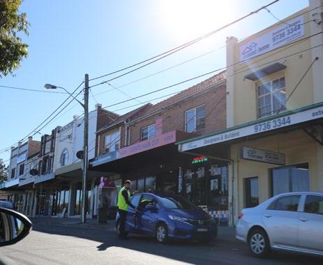
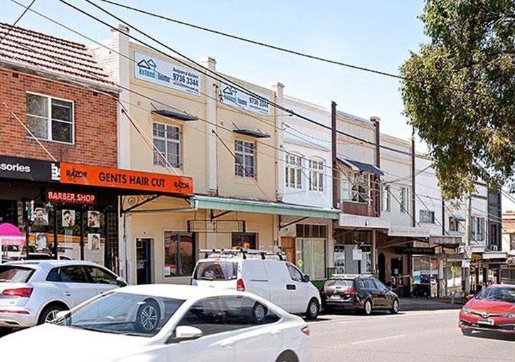
North Strathfield economy includes a range of retail, commercial, educational institutions and light industrial operating within the suburb. A small collection of restaurants and cafés are located on Queen Street opposite the North Strathfield railway station. Nearby, on Concord Road is the “North Strathfield Shopping Village” it has a larger row of shops that offer a range of services, including a small supermarket. The amenity of these shops is impacted by the volume of traffic on Concord Road. Both sets of shopping strips have lovely federation façades that should be maintained, but require revitalisation and further activation.
The site of the former Arnott’s Biscuits factory in George Street has been redeveloped as the ‘Bakehouse Quarter’ and features office space, restaurants, cafés, supermarkets and shops. Aldi, Fitness First and Outback Steakhouse are major tenants here. The head office and main call centre of NRMA Motoring and Services is also located in the former factory.
9 City of Canada Bay Local Planning Study SJB
Historic aerial of North Strathfield with the Arnotts Factory in the forefront.
Character, Culture and Context
2.2 Context analysis


The following context analysis has been take from the Stage 1: Background and Strategic Context Review that sits in parallel to this document. This is a snapshot with key findings that contribute to the character of the local area. Further background and analysis can be found in the Stage 1 report.
· Commercial, retail, food and beverage is located in the Bakehouse Quarter and is a well established entertainment precinct
There are small pockets of RE1 land within the precinct. The vast majority of the precinct is zoned for medium density residential (R3) and low density residential (R2).
· A block of neighbourhood centre (B1) is located along Queen Street directly across the train station. Commercial and retail activity is located at the edges of the precinct with limited amenity provided in the B1 centre on Queen Street.
Key findings
Directly south of the study area is Parramatta Road and M4 Motorway which are regional east-west vehicular arteries, connecting Western Sydney to Sydney CBD. Concord Road and George Street provide the main vehicular access into the precinct. These run north-south and create barriers for pedestrian movement with few
crossings and congested streets.
Pomeroy Street is the only east-west vehicular connection over the railway corridor, it is also congested and a pedestrian barrier,
· Access within the precinct is also restricted by the railway line and Powells Creek to the west.

10 City of Canada Bay Local Planning Study SJB
George St Queen St Concord Rd Wellbank St Shimpley St ParramattaRd UnderwoodRd Pomeroy St Malta St Warsaw St Lorraine St Gracemere St Beronga St Hamilton St Lemnos St Bressington Park Allen St Reserve Bill Boyce Reserve NORTH STRATHFIELD Waratah St Brussels St Mena St Argonne St Hillier St Napier St Nelson Rd Princess Ave Allen St M4Motorway CorreysSt POWELLS CREEK Key Precinct boundary 400m catchment Private roads Local roads Major roads
cycle routes
cycle routes
cycle routes
for future
for
Bus stop Dangerous crossing Open space Key Precinct boundary 400m catchment
- Low density residential R3 - Medium density residential Heritage
- Enterprise Corridor NI1 - Light industrial B1 - Neighbourhood centre B3 - Commercial core Open space
On-road
Off-road
Future
opportunities
connections Places
people
R2
B6
George St Queen St Concord Rd Wellbank St Shimpley St Waratah St WesternMotorway UnderwoodRd Pomeroy St Malta St Warsaw St Lorraine St Gracemere St MacKenzie St MacKenzie St Consett St Consett St Beronga St Hamilton St Lemnos St Bressington Park Allen St Reserve Bill Boyce Reserve NORTH STRATHFIELD Brussels St Mena St Argonne St Hillier St Napier St Nelson Rd Princess Ave Allen St
Key findings
Land use and activity
Movement and access
Character, Culture and Context
Context analysis
Open space, public domain and community
Very low levels of tree canopy* Low levels of tree canopy** Potential green link
Residential
built form and character
Key
· There are limited open spaces within the precinct with open space primarily to the west of the rail line. For recreational purposes the precinct relies on Allen Street Reserve along Powells Creek and Bressington Park on the western side, whilst the eastern side has access to Central Park and Henley Park in Concord.
· The naturalisation of the northern section of Powells Creek is attractive and successful, but reverts back to a concrete
Potential green link
Bressington Park Allen St Reserve Bill Boyce Reserve
Mena St
Brussels St
*Identified in the Canada Bay Urban Tree Canopy Strategy as a road with the fewest trees per 100m (Lowest 20% in the LGA)
**Identified in the Canada Bay Urban Tree Canopy Strategy as a road with the a low number of trees per 100m (Lowest 40% in the LGA)
Lack of community centre within the precinct.
UnderwoodRd
Warsaw St
Pomeroy St Malta St
Waratah St
Lorraine St Gracemere St CorreysAve CorreysAve Beronga St Hamilton St Lemnos St
Argonne St Hillier St Napier St
Wellbank St Shipley St WesternMotorway
NORTH STRATHFIELD
Allen St BAKEHOUSE QUARTER
The most prominent typology within the precinct is single detached houses.
Nelson Rd Princess Ave
Key George St Queen St Concord Rd
Key Precinct boundary 400m catchment Single detached house Duplex Townhouse Apartment building Shop-top housing Open space Heritage items
· Limited shop-top housing has been delivered on the B1 Neighbourhood centre zone where it is permissible.
· The Bakehouse Quarter is a significant area of heritage in which industrial buildings have been converted into an office, entertainment and retail precinct.
11 City of Canada Bay Local Planning Study SJB
George St Queen St Queen St Queen St Consett St Consett St Tenterfield St MacKenzie St MacKenzie St Concord Rd Wellbank St Shipley St WesternMotorway UnderwoodRd Pomeroy St Malta St Warsaw St Lorraine St Gracemere St Beronga St Hamilton St Lemnos St Bressington Park Allen St Reserve Bill Boyce Reserve NORTH STRATHFIELD Waratah St Brussels St Mena St Argonne St Hillier St Napier St Nelson Rd Princess Ave Allen St Key Precinct
400m catchment
boundary
Open
Community
Outdoor fitness Dog parks Cricket Athletic
Significant habitat
space Playground
garden Skate-park
findings
· There is a scattering of duplex or town house development primarily to the east of the train line. Apartment blocks are concentrated one block west along the railway corridor along George Street. findings
channel south of Lorraine Street. Bressington Park features extensive sections of significant habitat.
Character, Culture and Context
2.3 Identified sub-precinct character
Character is the intrinsic qualities which define an area. Within North Strathfield nine (9) existing distinct local character sub-precincts have been identified:


1 Bakehouse Quarter
An industrial heritage subprecinct redeveloped into a vibrant retail and commercial core. This is one of the local attractions and areas of high amenity.

2 Character Area (LSPS)
1-2 storey Federation and Inter-War bungalows with mature streetscapes, identified in Canada Bay Councils Local Housing Strategy as an area to be protected to retain diversity of housing types and neighbourhoods.
3 Town Centre Core Two storey shop top housing across from the railway station. There are opportunities to improve the streetscape and retail offering to make it a more attractive retail sub-precinct and civic heart.
6
5 School District
McDonald College and Our Lady of the Assumption Catholic Primary School characterised by bulky two storey buildings, courts and at grade car parks.
Low density residential (east) Area with mature streetscapes and a mixture of low density 1-2 storey residential detached dwellings and walk-ups with a disparate array of heritage houses scattered throughout the area.


7 Low density residential (west)
1-2 storeys of varying development quality, some of the area is identified as flood prone and connecting streets end in cul-de-sacs.
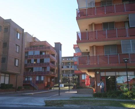
4 High density residential (west)
4-6 storey Residential Flat Buildings developments along the rail line. There is an opportunity to improve the streetscape and pedestrian connectivity within this subprecinct.

8 9
Parramatta Road Interface
Underutilised area predominantly of surface car parking and single storey buildings that are wedged between the Western Motorway overpass to the south and the railway line to the east.

Land potentially subject to flooding
Land in the vicinity of flood planning lots will need to have appropriate separation and transition down to the two storey low density residential flood lots.
12 City of Canada Bay Local Planning Study SJB
Concord Road Hillier Street Princess Ave Powells Creek Parramatta Road Argonne Street George Street 8 9 7 5 1 2 3 4 4 6
Queen St MacKenzie St Consett St Tenterfield St Queen St Queen St Wellbank St Shipley St Pomeroy St Malta St Warsaw St Lorraine St Gracemere St CorreysAve Beronga St Hamilton St Lemnos St Waratah St Brussels St Mena St Napier St Nelson Rd Allen St
Identified local character sub-precincts in North Strathfield
Community Feedback 3
3.1 Community feedback and values
A total of 112 people completed the online survey and 28 pins were dropped on the protect & celebrate map during the consultation process.
Comparison between age profile of survey respondents and suburb age profile indicates that a significantly higher proportion of 35-54 year old people responded to this survey. Under represented groups in the survey are 18- 34 year old who are likely to be a young working population and students, as well as elderly people (75+). 71% of survey participants have lived in the area for over 10 years.
The presence of the Bakehouse Quarter, the Powells Creek Corridor, Mason Park Wetlands and its walkability were some of the top attributes that were identified by the local community. They have a strong sense of who they are and what they would like to become in the future. The community would like to further celebrate the history of the local area, including Aboriginal history, and who they are today.
There is apprehension to new development because the community want their neighbourhood to retain the qualities that they love about it now (including being family friendly, strong community spirit, presence of heritage and federation homes, good access and connections) and ensure that any new apartment building has high quality finishes and is an appropriate scale. There is concern that North Strathfield will lose its local character and become a similar environment to neighbouring high density suburbs that have recently undergone an urban renewal process.
Survey respondents hope that the North Strathfield of the future is a place for everyone. They want places for people, with a public realm that is walk-able and high quality streets that lead to incidental encounters with one another. Enhancing the village feel and keeping the area as family friendly are key priorities.
Top attributes that describe the current North Strathfield place character:
Presence of the Bakehouse Quarter heritage precinct Walkable and easy to get around
· The local parks, creeks and foreshore areas
· Powell’s Creek Canal and its walkway/cycleway

· The connection to Sydney Olympic Park.
Stakeholders spoke about the area’s current character as being family friendly, green, quiet and walkable, with a strong sense of community and industrial history.
Top attributes of the desired future place character of North Strathfield:

Pedestrian friendly/easy to get around High quality buildings, streets and public spaces
· A local village feel
· Green and sustainable
· Safe and welcoming for everyone
Some stakeholders spoke about wanting to maintain the area’s current character as being family friendly and a place for locals, rather than becoming more of a destination.
The top 5 reasons for visiting this precinct were:
· live here
To go to the shops/retail
For the restaurants, cafes and bars
To catch the bus/public transport
To access services e.g. post office, medical
“Cater to diverse interests, make the precinct interesting and foster community interaction.”
- Survey Respondent
“We already have housing diversity. It’s a very inclusive area and we already have townhouses duplexes and units that go up to two to three levels.”
- Stakeholder Interview
Appetite for change
Participants hold mixed views about height in North Strathfield. Some are open to more height near the future metro station, while others don’t want to see buildings any more than 3-4 storeys anywhere in the precinct.
45% am OK with some future change throughout the precinct, provided that those changes complement our local character and protect our special places.
38% would like to see the precinct transition to a completely different look and feel.
15% Even though I understand that the precinct will likely change in the future, would prefer the precinct to stay exactly as it is now.
3% We shouldn’t worry about the character of the precinct. People should be free to do their own thing with their own property.
13 City of Canada Bay Local Planning Study SJB
Example of an existing 3-4 storey building on George Street with a green setback to the street and deep soil planting supporting mature trees (screening the building)
Powells Creek Corridor and bike path
3.2 Priorities for improvement
Housing Activities Public Space Access
According to survey respondents, priorities for improving activities in North Strathfield included; ‘outdoor dining and places to eat (37%)’; and ‘a number of things to do and see along the shopping street (36%).’
Survey respondents
· A number of participants highlighted the need for more outdoor dining and beautification in the precinct in George Street, Concord Road and Queen Streets. There is consensus that these retail precincts have a lot of potential, but require assistance to be flourishing neighbourhood centres.
· The possibility of North Strathfield becoming more of a retail hub or ‘destination’ brings up mixed emotions. While some would like to see this as a reality, others are more opposed to any change.
Some residents would like to see a better selection of restaurants and bars available in the local area. They would like dining to become a drawcard for North Strathfield. Others are more content with the local area remaining a quiet family centric neighbourhood.
There is a desire to celebrate cultural diversity in the community through the use of arts, and particularly recognise aboriginal people and culture.
Opportunities for gallery and exhibition spaces, community facilities, and music venues will support the local arts scene.
There is strong support for public art in this precinct to help connect people and soften hard spaces like under the M4 Western Motorway and along the Powells Creek corridor.
Stakeholder responses
Would like to continue to see the area as a family friendly place
According to survey respondents, priorities for improving access included; ‘traffic congestion (54%)’; and ‘walking and cycling connections across train lines and/or major roads (42%).’
Survey respondents
· There was particular concern that the volume of traffic would increase congestion if there was to be future development. Some participants identified one of the challenges being lack of through streets and connectivity.
There were a number of specific comments about better connecting George Street and addressing traffic congestion on Pomeroy and George Streets.
There is support for traffic calming, slower, more shaded and safer streets
Need to explore solutions for commuter car parking introducing timed parking in some areas to reduce commuters parking in local streets and adequate drop off/ pick up zones as part of the new metro station.
Strong support for increased quality and safety of cycle and pedestrian routes through the precinct and that link to the future metro station. This includes ensuring that the precinct is safe and accessible for people with a disability being able to easily move around.
· Strong support for improved safety of pedestrian crossings throughout the precinct (at grade and over the railway line).
Stakeholder responses
Narrow roads and a lack of connectivity were identified as contributing factors to existing congestion, while at the same time the cul-de-sacs (leading to Powell’s Creek) were viewed as a feature that should be protected.
According to survey respondents, priorities for improving public space included; ‘access to quality public spaces and parks (59%)’; ‘street trees for shade and comfort on the streets (53%)’; ‘feeling of safety (46%)’; and activities and play for children and families (43%)
Survey respondents
· Strong support for more trees, tree lined streets and paths and shade throughout the precinct.
Support for improved lighting in streets, along Powell’s Creek Canal and for people walking home from the train station generally.
· Improved accessibility of public spaces.
· More activities and spaces for children and families. Improved maintenance of parks and wayfinding signage.
A significant number of participants identified the need for improved lighting in streets, along Powell’s Creek Canal and for people walking home from the train station generally.
Opportunities to beautify and increase the level of activity along the George Street shopping strip.
Opportunities to share the place history including First Nations Peoples and Arnotts factory stories.
Stakeholder responses
Importance of protecting and celebrating heritage in the area including less obvious items like the heritage garden on the Queens Street side of North Strathfield Station and Arnotts Factory dedication plaques on local bench seats.
Survey respondents made some key observations around housing and future density:
Some people were of the view that North Strathfield already caters for housing diversity with various housing types and densities existing already. Conversely, others identified the need for a greater mix and the opportunity to provide the “missing middle” housing stock and affordable options, including key worker housing.
A need for sustainable, well designed homes and apartment buildings was identified, unlike what survey participants had seen in neighbouring suburbs.
Survey participants want to protect the sense of local history and items of heritage significance.
· Survey participants hope that the pace of residential development will be matched with local infrastructure improvements at the cost of the developer.
There was strong opposition to high rise apartment buildings. Some respondents welcomed medium or high density development, particularly west of the train line, close to the Metro station.
Terraces / town houses (44%) and 6-8 storey mid-rise apartments (42%) were the top two preferences for housing immediately surrounding the metro station.
· Houses (46%) and terraces / town houses (46%) were the top two preferences for housing within a 5 minute walk from the metro station.
65% of respondents believe that future development should be concentrated around the station.
14 City of Canada Bay Local Planning Study SJB Community Feedback
Survey respondents identified the places that they most value in and around North Strathfield.

The most valued spaces within North Strathfield (that received more than one comment) were primarily clustered around the Bakehouse Quarter on George Street and the intersection of Queen and Wellbank Streets including the North Strathfield Train Station. These locations are two pockets in the local area that have considerable existing amenity and historic significance. These spaces are special to the community and present an opportunity for further improvements in the public realm.

The community of North Strathfield clearly love the outdoors and value their public open spaces. Survey respondents highlighted the Powell’s Creek Corridor, Bicentennial Park, and Central Park as some of their favourite local places. None of these public open spaces are within a 400m walk from the proposed Metro location, or within the boundary of the study area. It is important that the community have high quality open space in their local walking catchment.

15 SJB Community Feedback
6 13 8 14 11 1 4 3 5 2 9 7 10 12 Map ref Location of Interest Number of responses 1 Bakehouse Quarter (36) 2 Powell’s Creek Corridor (27) 3 North Strathfield Station (27) 4 Arnott’s Biscuit Factory (21) 5 George Street (7) 6 Bicentennial Park (7) 7 Concord Road Shops (4) 8 Majors Bay Road (4) 9 Wellbank Street (3) 10 Queen Street (2) 11 Central Park (2) 12 Allen Street (2) 13 Sydney Olympic Park (2) 14 Yeralla Estate (2)
3.3 Special places map
10 2
Special places key - places with 2 or more nominations Queen
Powells Creek Corridor 1
Identified special places in North Strathfield
Street shops
Queen St Consett St MacKenzie St George St Queen St Concord Rd Wellbank St Shipley St Pomeroy St Malta St Warsaw St Lorraine St Gracemere St CorreysAve Beronga St Hamilton St Lemnos St Waratah St Brussels St Mena St Argonne St Hillier St Napier St Nelson Rd Princess Ave Allen St
The Bakehouse Quarter
Local Character Area Statement 4
4.1 Desired future character
The ‘Local Character Statement’ consists of a set of principles that come under the heading of Movement, Built Form, Landscape, Land Use, and Character and Culture.
Each of these categories aligns with sub-sections of the DPIE Character Wheel. Within each subset of principles is a diagram that shows how they align to the Wheel. For instance, the subheading ‘Movement’ considers the elements of ‘safety and access,’ ‘active transport and configuration,’ road network and parking’ from the DPIE Character Wheel. There can be overlap within the subcategories or principles taken from the wheel.
The principles articulate the opportunities to ‘Change, Maintain and Enhance’ aspects of the study area, using language that is synonymous with these terms.
Following on from the principles is a break down of future character areas identified within North Strathfield - a high level statement about each neighbourhood and the specific aspects of that location that make it unique.
Character and Culture
Enhance heritage and culture by celebrating the local community and its diversity through community education, public arts, and culturally relevant festivals.
Create high quality public spaces for the community life to flourish. Empower the social life of the neighbourhood with high quality streets, parks , plazas and community facilities. Provide places that bring people together, where people can linger, children can play and friends can meet.
Enhance the retail environment that caters for the local population and brings vibrancy to the streets of North Strathfield.
Identify spaces of cultural significance to the Wangal people, the original custodians of the land, and recognise their heritage and culture through art and signage.
· Celebrate the manufacturing heritage of North Strathfield and ensure that the historic Arnott’s factory buildings are maintained.
Enhance the opportunities for leisure activities within North Strathfield.
· Support the local economy and employment by diversifying the retail opportunities adding commercial office space in the mixed use areas.
Maintain and enhance safety and comfort in the public realm where the community comes together.
16 City of Canada Bay Local Planning Study SJB
SAFETYPUBLICSPACE TOPOGRA HY TREECANOPY ACT VE TRAN POR COMFORT OPENSPACEINTERFACE HEIGHT AND DENS ITY P U B L C / P R V A T E D O M A N ACCESS LE SURE HOUS I NG EDUCATION COMMUNITYFACILITIESHERITAGEANDCULTURE PUBL CTRANSPORT UB C RANS O T PARKING LOCALECONOMYEMPLOYMENT RETAIL RETAIL Culture and Character
Land Use and Activation
Create a vibrant mixed-use precinct around the Bakerhouse Quarter with outdoor dining and civic spaces for the community to gather along George Street.
Promote the co-location of active high order community facilities (clinics and community centres) in a highly accessible location to revitalise key nodes to create hubs of activity near the Bakehouse Quarter.
Revitalise the Queen Street shopping strip into a vibrant little village centre.
Support the growth of educational uses in the centre of the suburb.
· Provide a high quality public open space in a short walking distance of residential areas. At a minimum, there should be one on either side of the train line.
Maintain the character area as a low density residential area.
Movement
Enhance the local village feel in North Strathfield by prioritising walkability and other modes of active transport.
Enhance pedestrian safety by providing safer connections, raised zebra crossings, or signalised pedestrian crossings in key locations.
Improve accessibility throughout the entire suburb with consistent kerb ramps and pavements that are even, continuous and wide.
Enhance the safety of evening commuters and enable active recreation after hours by improving street lighting in key locations.
Ensure connectivity and interchange at the North Strathfield Station and enhance local access to the station with more local public transport connections, end of trip facilities and walkable access.
· Alleviate congestion on the local road network; reducing car dependency and minimising incentives for shorter trips; improve drop off/pick up zones for schools and the station; and changing configuration of the road network and permeability, namely exit points onto major roads.
Continue to improve connectivity to and along the Powells Creek to facilitate and active transport corridor.
Build a safe, connected and integrated cycling network that is supported with the necessary infrastructure (such as end of trip facilities).
17 City of Canada Bay Local Planning Study SJB Local Character Area Statement SAFETYPUBLICSPACE TO OGRAPH TREECANOPY ACTIVE TRANSPORT COMFORT OPENSPACEINTERFACE HEIGHT AND DENS TY C / P R I V A T E D O M A N ACCESS LE I SURE HOUS NG EDUCATION COMMUNITYFACILITIESHERITAGEANDCULTURE PUBL CTRANSPORT ROAD N TWORK PARK NG LOCALECONOMYEMPLOYMENT RETAIL CONFIGURATION Movement
SAFETYPUBLICSPACE OPOGRA HY TREECANOPY ACT VE RAN PORT COMFORT OPENSPACEINTERFACE HEIGHT AND DENS TY P U B C / P R V A T E D O M A N ACCESS LE I SURE HOUS NG EDUCATION COMMUNITYFACILITIESHERTAGEANDCULTURE PUBL CTRANSPORT PU L TRANS O T PARK NG LOCALECONOMYEMPLOYMENT RETAIL CONFIGURATION Landuse
Desired future character
Desired future character
Landscape
Enhance the tree canopy in the public domain by planting additional street trees throughout North Strathfield.
· Implement the objectives and utilise the measures and benchmarks of the GA NSW’s Green Grid, Greener Places documents and Draft Connecting with Country.
Create a network of smaller public spaces, with local parks, plazas, community gardens and play spaces for children within the local 5 minute walking catchment.
Provide safe and comfortable spaces for the community, where all ages can participate.
· Be mindful of the topography and flooding risks around Powell’s Creek.
Open space is to be fit for purpose, reflecting community desires and cultural use of space. Provide access to appropriate recreation facilities and amenities, such as toilets, barbeques, and bins.
Public spaces are to be well maintained and upgraded as they age, with particular care for landscaping and facilities.
· Access to higher order leisure and recreation facilities in neighbouring suburbs and foreshore walks should be prioritised.
Continue to enhance and develop the amenity of the Powells Creek corridor and improve its accessibility and safety.
Built Form
Protect and maintain the heritage and conservation areas of North Strathfield from future redevelopment.
Create appropriate transition building height from low density into higher density areas.
Ensure a high quality of design and materiality for new developments that reflects the desired character of the area.
Revitalise areas with poor amenity in the south and west of the rail corridor with higher density development.
Increase the variety of housing and buildings types on offer by encouraging more low-rise medium density urban typologies (terraces and integrated low-rise apartments) that interface with Powells Creek and close to the station.
· Change the urban configuration and provide greater permeability near the train line with through site links that connect with future crossing points.
Maintain the family friendly nature of North Strathfield and ensure that the new development offers dwelling diversity with sufficient offer of 3+ bedrooms and a mix of affordable housing options.
· Integrate retail, commercial, residential and a community facility with sensitivity to local residential areas in the mixed used areas.
18 City of Canada Bay Local Planning Study SJB Local Character Area Statement
SAFETYPUBLICSPACE OPOGRA HY TREECANOPY ACT VE RANSPORT COMFORT OPENSPACEINTERFACE HE GHT AND DENS ITY P U B L C / P R V A T E D O M A N ACCESS LE I SURE HOUS NG EDUCATION COMMUNITYFACILITIESHERITAGEANDCULTURE PUBLICTRANSPORT PUB C TR N POR PARK NG LOCALECONOMYEMPLOYMENT RETAIL RETA L
space
Open
SAFETYPUBLICSPACE TOPOGRA HY TREECANOPY ACT VE TRANSPORT COMFORT OPENSPACEINTERFACE HEIGHT AND DENS ITY P U B L C / P R V A N ACCESS LE SURE HOUS I NG EDUCATION COMMUNITYFACILITIESHERTAGEANDCULTURE PUBL CTRANSPORT PUB C TRAN POR PARK NG LOCALECONOMYEMPLOYMENT RETAIL CONFIGURATION Built Form
Desired sub-precinct character
North Strathfield has been divided into nine (9) separate future character subprecincts based on the feedback from the community and site analysis, as well as considerations for strategic drivers of change (such as PRCUTS and a new Metro).


Mixed use sub-precinct

Bakehouse Quarter
The Bakehouse Quarter is an industrial heritage precinct that was redeveloped into a vibrant retail and commercial core in the 1990s after the closure of the Arnott’s Factory. There is an opportunity to strengthen and increase the activity within this precinct in accordance with recommendations in the Parramatta Road Corridor Urban Transformation Strategy with heights up to eight (8) storey with a permitted height of 32m as per PRUCTS. Adding mixed uses, including apartment buildings will bring more activity to the precinct, while retaining the heritage nature of the Bakehouse Quarter. A network of streets and laneways will weave through the sub-precinct to create an intimate spaces and vibrant retail precinct.
Parramatta Road interface
The underpass area will also be upgraded into a new public open space that is activated by retail at lower levels and provided ample lighting. The fundamental structure of the interface will remain the same, as it will always be wedged between the Western Motorway overpass and Parramatta Road to the south and the railway line to the east. For this reason appropriate acoustic treatment will be important on any residential development.
George Street public realm upgrades

The public realm along George Street will be upgraded be a more vibrant and active space. Orienting the retail and alfresco dining onto a comfortable, high amenity street. Adding in soft landscaped spaces, tree canopy, plazas and prioritising pedestrian spaces will continue to lift the character support spaces where people want to linger.


19 City of Canada Bay Local Planning Study SJB Local Character Area Statement
Concord Road Hillier Street Princess Ave Powells Creek Parramatta Road Argonne Street Conway Ave Rothwell Ave George St George Street 8 9 7 5 1 2 3 4 Future local character
in North Strathfield 1 6
sub-precincts
Acoustic measures to minimise impact of rail and freeway noises.
Significant landscape upgrades to George Street with pedestrian priority streets.
Warehouse facade preservation and sympathetic integration of new development.
Provide a safe new open space under the M4 Western Motorway.
A new community facility integrated into new development.
Queen St Consett St MacKenzie St Tenterfield St Queen St Wellbank St Shipley St Pomeroy St Malta St Warsaw St Lorraine St Gracemere St ConreyAve Beronga St Hamilton St Lemnos St Brussels St Mena St Napier St Nelson Rd Allen St
The activation on George Street and the retail offer at the Bakehouse Quarter to be improved.
4.2
Desired sub-precinct character
3 Residential (lower west)
This sub-precinct will accommodate medium density development up to five (5) storeys that will interface with the mixed use Bakehouse Quarter. It will also contribute to the amenity and safety of the of the Powells Creek Corridor and bring the verdant green space into the sub-precinct. Flooding constraints will inform the intensity of development in this sub-precinct.
The interface with George Street should be active, with retail provision at the lower levels and public realm upgrades to encourage walking and the prioritisation of active transport modes in general.
School District
The school district is integral to the community life of North Strathfield. This character area can be improved upon with future development providing a better interface with the street and providing more amenity and character along George Street.


A change of land use or future redevelopment should facilitate improved pedestrian connections to the metro/train station and the provision of a plaza/civic space. Up to eight (8) storeys (32m) will be permitted for new development and it should also seek to ensure that significant trees are retained on site. Student drop off and pick up times also need to be managed to mitigate congestion at peak hours.
Low density residential (upper west)
This sub-precinct will accommodate medium density development with three (3) and four (4) storeys products, so long as it complements the neighbouring character, including setbacks, street grain and dwelling envelopes.


The connection with Powells Creek Corridor is important and greater connection should be encouraged. The provision of a new public open space and a children’s park will address the current deficit of open space and provide for the young population moving into North Strathfield.


20 City of Canada Bay Local Planning Study SJB Local Character Area Statement
2 4
Boulevard streetscapes with seating and tree canopy on George Street and Queen Street
A new/improved park and playground for children. If land use were to change, the School District sub-precinct should provide high quality mixed use development, a high quality plaza and improved connection to the station.
Integrate the natural landscape into development and provide passive surveillance of public spaces, particularly the Powells creek corridor.
Improvement of drop-off and pick up areas.
School interface should be vibrant and interactive with the street. Shared amenities for use by the wider community.
Desired sub-precinct character
6 High density residential (upper west)
This sub-precinct has existing 4-6 storey residential flat building developments along the rail line. The recent nature of the strata development indicates that it is unlikely that the built form will change significantly in the future.


Improvement of the streetscape and pedestrian connectivity along George Street within this precinct will lift the amenity in this area. Encouraging greater activity on the street from existing retail offer, providing soft landscaping and adequate lighting will support safety and comfort in the street, adding to the vibrancy of the northern section of George Street.
Character area (LSPS)
1-2 storey federation and inter-war bungalows with mature streetscapes, identified in CCB’s Local Housing Strategy as an area to be maintained, protecting the established character of the existing neighbourhood.

The streets and public realm can continue to be improved upon, complementing the low density context with bicycle lanes, additional street trees and time limited parking for vehicles that do not belong to local residents. Crossings and better connectivity across Concord Road will also make it safer for students walking to North Strathfield Primary School.


Residential (east)
This character sub-precinct will undergo some change by integrating a greater mix of housing typologies. This area will be intensified due to it’s strategic location and the existing development that has already taken place. Some sections will remain low density 1-2 storey residential detached dwellings and walk-ups.
Heritage items will be protected with interfacing development sensitive to the urban form. Missing middle product is appropriate in this location up to two (2) storey or three (3) storeys up to 9m, where multi-dwelling housing (terraces) are provided in accordance with LEP.

Upgrading Pomoroy Street and the network of roads that connect into Concord Road with better pedestrian and bicycle infrastructure will significantly improve this area. In particular, the rail crossing, the peanut shaped roundabout and the Gacemere Street roundabout require better pedestrian/bicycle crossing points.

21 City of Canada Bay Local Planning Study SJB
Local Character Area Statement
5 7
Encourage active frontage in existing retail outlets. Deepen the landscape planting interfacing with the street. Improve the pedestrian experience around the roundabout of Pomery Street.
Area to be maintained according the CCB’s housing strategy with mature street trees and federation and inter-war bungalows.
Encourage greater tree canopy with road centre verges on wide streets
Protect and enhance the existing tree canopy.
Two storey multi residential building that compliments the stand alone nature of neighbouring development.
Create a boulevard along George Street with public realm upgrades that focus of walkabilty and places for the community to comfortably linger.
Local Character Area Statement
Future local character sub-precincts
Town centre core
The shop top housing that is situated opposite the railway station is to maintain its central role in the community and retail presence at street level. There are opportunities to improve the streetscape and retail offering to make it a more attractive precinct and form a civic heart through its relationship to the train station and station plaza.


Shop top housing could be transformed into medium density mixed use developments of up to four (4) storeys that retain the existing façades and the fine grain nature of the street. This will revitalise the Queen Street shops and enable preservation of the local character.

9
Land potentially subject to flooding
Existing planning controls will be maintained. Land in the vicinity of flood planning lots will need to have appropriate separation and transition down to the two storey low density residential flood lots.
22 City of Canada Bay Local Planning Study SJB
8
Shop top housing with existing facade maintained - not reflecting proposed heights.
Small scale wine bars and boutique attractions.
Station forecourt and plaza on Queen street to be upgraded and expanded.
SJB Architects
sjb.com.au
We create spaces people love. SJB is passionate about the possibilities of architecture, interiors, urban design and planning.
Let’s collaborate.
Level 2, 490 Crown Street
Surry Hills NSW 2010 Australia
T. 61 2 9380 9911
architects@sjb.com.au sjb.com.au