
Case Studies In Urban Housing
Planning, Regulation, Design
CHRISTOPHER M. PIZZICase Studies in Urban Housing
Work by undergraduate architecture students at Academy of Art Univeristy in San Francisco, in the Fall of 2016.
Malak Bellajdel
Jiajun Cao
Meng Fan
Oskar Frick
Xiaohuan Gao
Nhat Huynh
Tommy Lan
Fabio Lemos
Fang Liu
Brianna Lorn
Benjy Michel
Vy Nguyen
Hussein Saleh
Alexandria Santori
Qiaoyu Zheng
Christopher Pizzi Instructor, Site Design + Mapping Academy of Art Univeristy, San Francisco
Figure Eight
Copenhagen, Denmark
www.big.dk/#projects-8
Project Data
Location / Address: Richard Mortensens Vej, 2300 København S, Copenhagen, Denmark
Designer(s):Bjarke Ingels Group architects
Overview
Figure 8 is a mixed used developement built as an 8 shape. It is located in Orestad, the edge of Copenhagen city, Denmark. The project was designed by the Danish architect Bjarke Ingels in 2010. The building sits on 61000 m2 site and offers various dwelling units ( apartments, row houses, penthouses) , retail and of fices.
Instead of spreading each program into blocks, the bow-tie building characterised itself by stacking different horizantal layers. To benefit from the view, sunlight and fresh air, residential units are stacked on the top layers while the commercial program unfolds at the bottom layers to blend with the city. The southwest corner is pushed down to allow air and light to the southern courtyard. Even though the layers seem seperate from one another as a program, they are connected by a pathway and a cycle track that reaches all the way up to the10th floor. The building is penetrated by a 9m wide public path connecting the park area to the west and the channel area to the east.


Softscape Area: 2000 m2

Building Heights10 Stories, 30 m
Total Floor Area Of All Buildings45,000 SF
Floor Area Ratio (F.A.R.):0.97 Dwelling Units and Types476
Bellajdel Malak
The Figure 8 utilizes its large site to create a sense of community using gardens, courtyards and pathways. It also offers every unit in the building a nice view, a good amout of natural light and ventilation. In order to relate the project to its site and the surrounding farms, two sloping green roofs were strategecilly placed totalling over 1700 m2. The green roofs reduce the heat island effect and absorb the polluting particles.
The project is a good example of horizantal social connectivity and interactions through the series of ramps and paths provided. It is also a meeting point where the suburban life blurs with the energy of the city and where the commercial and the residential co-exist.
" 8 House is our second realized example of architectural alchemy - the idea that by mixing traditional ingredients, retail, row houses and apartments in untraditional ways - you create added value if not gold. The mix allows the individual activities to find their way to the most ideal location within the common framework - the retail facing street, the of fices towards northern light and the residences with sun and views to the open spaces." Bjarke Ingels, BIG
Else Alfelts way Otto Baches St Train Railroad Robert Jacobsens St Robert Jacobsens School 8-Tallet Tanya Olsen
Concepts Richard Mortensens St Parking Parking KanonWay EjlirBellisWay KalvebodSt Parking Parking Else Alfelts way Richard Mortensens St Robert Jacobsens St KalvebodSt Train Railroad Otto Baches St Connecting the east side to the west Light/ view study Lowering the southwest corner
Catring
Year Completed2010 Land Uses: Residential/ Of fices/ Retail Dimensions: 230 m2 X 110
Site Area:
m2
62000 m2 Building Footprint Area:60300 Hardscape Area: 25300 m2
dwelling units Density32 Dwelling Units per Acre (DU/Ac) Parking Provided:0 Spaces In Structured Garage 64 Spaces Surface Parking Parking Ratio: 0.14 Spaces per Dwelling Unit Open Space: 5 Acres Parks 2 Acres Landscaping 0 100' 200' 300' 500' 1" = 100' at full size (24" x 36")
240 / Fall 2016 / Project 2
ARH
Horizantal stacked layers
MIRADOR APARTMENTS

SANCHINARRO, MADRID, SPAIN
Project Data
Location / Address: Sanchinarro, Madrid, Spain
Designer(s):MVRDV

Overview
emphersizing different classes/ functions of units. While modern architects tends to eliminate the difference of units of each apartments.
MvRdv and Blanca Lleo was commissioned in the northeast outskirts of Madrid Paul de Sanchinarro build a large collection of homes, this is a low-rise building a horizontal direction of the inner court, then
And this will create the Mirador residential neighborhood along its side of the platform; residential construction has become a stacked dwelling units; streets will accordingly become the vertical transport space.
Floor Area Ratio (F.A.R.):2.94
Dwelling Units and Types156 Stacked Flats
This was originally designed from MvRdv on the "three-dimensional city" concept accessibility, space and function program, and functional plan mixing four parts. Through the "density" of the limits of the maximization and optimization of use of land in limited objective conditions, thereby improving the uneven density distribution architecture, building land irrational status quo, where the density does not mean the plane occupy a greater area but extends to the entire 3D space, the pursuit of the expansion of space capacity and functional capacity building under limited conditions. Mirador residential use of the realization MvRdv's "threedimensional city" concept of the operating practices of the "Flip (Flip)" mode.


Dimensions: 450'
Site Area: 5.68 Acres (247,570 SF)
Footprint Area: 34,659 SF (14% Of Site Area) (A) Hardscape Area: 148,542 SF (60% Of Site Area)
Softscape Area: 64,368 SF (26% Of Site Area) (C) Building Heights21 Stories, 120,899 SF From Grade
Acres
Year Completed2005 Land Uses: Residential
X 550'
(A+B+C) Building
(B)
Total Floor Area Of All Buildings16.7
Spaces Surface Parking
Ratio: 0.41Spaces per Dwelling Unit Open Space: 2.3 Acres Parks 1.75 Acres Landscaping Setbacks: 236'Front, 80’ Side, 236' Back 0 100' 200' 300' 500' 1" = 100' at full size (24" x 36") Jiajun Cao
240 / Fall 2016 / Project 2
Density27.46 Dwelling Units per Acre (DU/Ac) Parking Provided:64
Parking
ARH
Justus van Effen Complex
Spangen, Rotterdam, Holland
Project Data

Location / Address: Justus van Effen Complex, Spange, Rotterdam, Hollan


Designer(s):Michiel


Overview
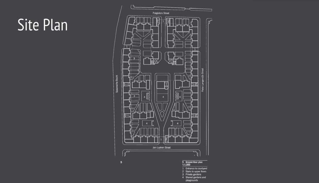
Justus van Effen Complex is a modern style multi-family housing on the Justus of Effenstraat in Rotterdam, Spangen designed by architect Michiel Brinkman between 1919 to 1922 and rebuilt in 2010 and the courtyard redesigned by the designer Michael van Gessel. It is also renamed as Justuskwartier now.
The building is near a harbour so there are a lot of labour workers living in this building. Because of this is a residential four storey apartment complex, the and progressiveness. For the building itself, it including 264 apartments counts are galleries. For every units, it including a living room, three bedrooms, kitchen, bathroom and central heating system. For the perimeter and central units including directly go to the ground and every entrance to the dwellings are made from the semi-private courtyards.
The building is built face to north-south side. Because of the location of the building and also the opening of the interior it will catch more natural light into the building. And the designer painted the wall which is facing to the courtyard to a lot of tall trees and shrubs to create the shadows and it can also shade lower level apartments.
As we know, the building got rebuilt in 2010 by Miller & Co architects and architects Hebly Theunissen, and their goal to do that is restore and return the building to its original value. So, they keep the original design but they merged original 264 units into 164 units with different layout and sizes. After Michael van Gessel redesigned the landscape, there is no private property, but as many green as collective use. And the bathhouse is not only for showers and also has space for people to do the laungry and drying. Also, the building and courtyard are opening to the public to allow poeple to visit and relax.
Uses: Multi-Family Housing Residential Dimensions: 3,648 × 2,736 meters
Site Area: 3.27 Acres (142,272 SF) (A+B+C) Building Footprint Area: 53,535 SF (37.6% Of Site Area)
Hardscape Area: 50,287 SF (35.4% Of Site Area) (B) Softscape Area: 38,450 SF (27% Of Site Area) (C) Building Heights264 Units, 50 M eters From Grade Total Floor Area Of All Buildings569,088 SF Floor Area Ratio (F.A.R.):1.0 Dwelling Units and Types264 Units of Single-Family House - Basement 277.7 SF - Ground Floor 734.1 SF - 1st Floor 612.5 SF - 2nd Floor 612.5 SF Density80.73 Dwelling Units per Acre (DU/Ac) Parking Provided:80 Spaces Surface Parking Parking Ratio: 5.0 Spaces per Dwelling Unit Open Space: 2.0 Acres Landscaping Setbacks: 7'-0" Front, 10’-0" Side, 15’-0" Back 0 100' 200' 300' 500' 1" = 100' at full size (24" x 36") Meng Fanvv ARH 240 / Fall 2016 / Project 2
Brinkman Year Completed1922, Rebuilt in 2010 Land
(494 x 288 Feet)
(A)
Drawing byMeng Fan BELLAMYSTRAAT AAGJE DEKENSTRAAT BETJE WOLFFSTRAAT MATHENESSERDIJK MATHENESSERDIJK POTGIETERSTRAAT PIETER LANGENDIJKSTRAAT SPAANSEBOCHT JANLUYKENSTRAAT PIET PAALTIJENSPLEIN VANHARENSTRAAT VAN LENNEPSTRAAT VAN LENNEPSTRAAT BILDERDIJKSTRAAT MATHENESSERDIJK SCHAEPMANSTRAAT SPAANSSEWEG TJALKLAAN BARKASSTRAAT BAARDSESTRAAT 494’-0” 288’-0”
Java-eiland
Amsterdam, North Holland, Netherlands
Project Data
Overview
Java Island or Java-eiland in Dutch is a human-made island located northeast of downtown Amsterdam, Netherlands. The buildings on the site were constructed on 2002 until 2006. The island is connected to the KNSM Island, which was built in 1903. KNSM stands for the Royal Dutch Steamboat Shipping Company. Docks and headquarter were located on KNSM Island. In 1977 the shipping industry left the island when KNSM emerged with other shipping companies to become Nedlloyd. After the 1977 KNSM Island became a place for poor and homeless people. In the 90’s residential developing projects emerged, and a bit later the Java Island took shape. The method they used to create the island was by dredging water. Dredging water is digging up sediments from shallow water and disposing of it somewhere else. Dredging water is used to create islands or making waterways, since major parts of Netherlands is sub-sea level and about 17% of the country’s area is human-made islands.
The Master plan was designed by Sjoerd Soeters, a well know post-modernist four 20’ wide canals. The concept was applied onto the façade of all the building, and the diverse forms the window design are set at varying distances from each other. As a result, it creates an attractively varied frontage, incorporate with a contemporary interpretation of the traditional ornamental architecture (Java Eiland Amsterdam). The residential apartments on the islands were developed by a lot of young and talented architects. The reason for allowing many architects designed the neighborhood was to get the variety similar to the canal frontages in Amsterdam. There are only residential housing on Java Island, while KNSM Island both have commercials and residential buildings. The master plan prioritizes the use of bikes as transportation. Amsterdam is known for the density of bicycle
Although, there are plenty of parking spots for cars in the streets and subsurface garages.
"Java Eiland Amsterdam [NL]." Visuals. N.p., n.d. Web. <http://www.kcap.eu/en/ projects/v/java_eiland/>.
/ Address: Sumatrakade, Amsterdam, Netherlands
Soeters, KCAP
Completed2006 Land Uses: Residential Dimensions: 475’ X 430’ Site Area: 4.707 Acres (205,027 SF) (A+B+C) Building Footprint Area: 67,551 SF (32.9% Of Site Area) (A) Hardscape Area: 89,104 SF (43.5% Of Site Area) (B) Softscape Area: 48,372 SF (23.6% Of Site Area) (C) Building Heights4-8 Stories, 96' From Grade Total Floor Area Of All Buildings374,331 SF Floor Area Ratio (F.A.R.):1.825 Dwelling Units and Types200 Stacked Flats Density40.5 Dwelling Units per Acre (DU/Ac) Parking Provided:132 Parking Garage Underneath Building 68 Spaces Surface Parking Parking Ratio: 1.0 Spaces per Dwelling Unit Open Space: 0.11 Acres Parks 940' Waterfront Setbacks: 17'-0" Front, 0’ Side, 6’ Back 0 100' 200' 300' 500' 1" = 100' at full size (24" x 36")
Location
Designer(s):SJ.
Year
240 / Fall 2016 / Project 2
Oskar Frick ARH
Jan Schaeferbrug Javakade Brantasgracht Lamonggracht Sumatrakade Site Boundary 430' 475' IJhaven Amsterdam Java-eiland Regional location map Canal system in Java Island Bike parking at the waterfront
ARMSTRONG PLACE SENIOR HOUSING
San Francisco -California -USA
Project Data


Overview

Armstrong Place Senior Housing was designed by David Baker & Partners in 2011. The building was named based on it's own location, standing at the corner of Armstrong Avenue and 3rd Street in San Francisco. The building was designed into two areas of housing: Stacked townhouses and Mendell townhomes. Each unit of Stacked townhouses has two sections of townhouses stacked upside down on top of each other. Users of lower units access the living space before accending to sleeping spaces while users of upper units do in the opposite way: sleeping spaces then living spaces. This design has two functions: keeping keeping sleeping units from affected by living space activities. Mendell townhomes has ten units of 3 stories townhouses with private garages along Mendell street.
The targets of Armstrong Place housing are to provide a high-quality housing for seniors and affordable living expense for growing families within the industrial/

David Baker & Partners got the painted wall and windows design from the concept of African-American classical culture and traditional texture as well as skin. There is a symbol of African tribal which is called Ashanti tribal placed in the courtyard at the center of plan project. This symbol constitutes hope, unity, love, power, wisdom and security for the Ashanti tribal.
The building also completed LEED goals as well as innovative building technology to provide the friendly living environment. Some of the newest updated technologies are storm water treatment, solar arrays ( using to heat water and light up space), natural materials as well as furniture.
To both maximize access to surrounding area and equally maintain the views for every apartment unit, the architect designed the landscaped pathway into mews path throughout the site and within the building.

Every family townhouse is designed with equal private courtyard shared. The large center public courtyard above the parking lot level is the highlight of Armstrong Place . Outdoor activities are encouraged such as seating, gardens relaxing area or picnic. This is also the location of stormwater treatment methods. Sources: http://www.dbarchitect.com/ http://www.archdaily.com/

/ Address: 5600 3rd St, San Francisco, CA 94124
Baker & Partners Year Completed2011 Land Uses: Residential Dimensions: 707 x 218 (Ft) Site Area: 159,783 SF/ 3.46 Acres Building Footprint Area: 69,702 SF/ 1.6 Acres (44%) Hardscape Area: 52,502 SF/ 1.2 Acres (33%) Softscape Area: 37,579 SF/ 0.9 Acres (23%) Building HeightsAbout 55 Ft with 5 Stories and 45 Ft with 3 Stories Total Floor Area Of All Buildings278,808 SF/ 6.4 Acres
Area Ratio (F.A.R.):1.7
Units and Types Density34 Dwelling Units per Acre (DU/Ac) Parking Provided:124 parking units Parking Ratio: 1 (Cars per units) Open Space: About 30,000 SF of landscape Setbacks: 40' Front, 10’ Side, 20’ Back 0 100' 200' 300' 500' 1" = 100' at full size (24" x 36") Nhat Huynh ARH 240 / Fall 2016 / Project 2
Location
Designer(s):David
Floor
Dwelling
The center courtyard sketchSection of each stacked townhouses
Fabric concept from African-American culture
Hufeisensiedlung
Berlin, Germany
Project Data
Location / Address: 12359 Berlin, Germany
Designer(s):Bruno Taut
Year Completed1933
Land Uses: 263,400 ft 2 Dimensions: 537 ft by 574 ft
Site Area: 263,400 ft 2
Building Footprint Area:61,840 ft 2

Hardscape Area:31,160 ft 2
Softscape Area:170,400 ft 2
Building Heights42 ft
Total Floor Area Of All Buildings247,360 ft 2

Floor Area Ratio (F.A.R.):0.94

Dwelling Units and Types
Density59.54 DU/Acre
Parking Provided:100 Street Parking Parking Ratio: 2.5 spaces per 1,000 ft 2

Overview
Hufeisensiedlung is a housing project also known as the “Horseshoe Estate“. The estate was build to help the shortage of real estate resources after the World War I. commerical using; those facing the garden is dwelling units just like the 2nd and 3rd
suround the open garden, in order to creat a open space for the residents. There is also a pond in the center of the green garden. The shape of the path and the pond of the green scape is also mimicing the shape of the building, this design decision not only harmonizes the building and the green space, but also highlights the idea of the “Horseshoe”. This project has 360 units which holds over 1000 residents. In year 2008, the Hufeisensiedlung is awarded “World Heritage Site” by the United selected as the garden monument by the Berlin goverment.

Open
0 100' 200' 300' 500' 1" = 100' at full size (24" x 36") Tommy Lan ARH 240 / Fall 2016 / Project 2
Space: 201,560 ft 2 Setbacks: 8 ft
Pilotengasse Housing

Vienna, Austria
Project Data
Overview
The Pilotengasse housing project by Herzog and de Meuron, was constructed in 1992 in Vienna Austria. Designed with a residential purpose, this building complex possess 200 terraced houses and free standing units. Taking the site of this project was planned around a central convex space.
The architects, designed this complex with the idea of three different unit program by enclosing the outside gardens by the one and half story studio. The second type of unit is the rectangular layout. This one contains the majority of its services on the right side of the unit. On the left there is a winding staircase that

The distribution of the low-rise houses and the crossing passages were done details to the terraced houses and creates an atmosphere that emphasized the unity of the project.
The site layout and the project’s design was really successful. The architects focused on the connections between the units and a harmonious circulation created on a grid kind of formation. The relationship between the site and the complex design presents its self in an organized planned form.

Hausfeldstrasse
PropertyLine50'X70' PilotengasseSt.
St. Hausfeldstrasse St.
Josef Frank Gasse
Josef Frank Gasse
ReglergasseSt.
Location / Address: 1220 Wien, Vienna, Austria Designer(s):Herzog & de Meuron Year Completed1992 Land Uses: Residential Dimensions: 1,000’ X 700’ Site Area: 14.7 Acres (642,067 SF) (A+B+C) Building Footprint Area: 157,185.4 SF (25% Of Site Area) (A) Hardscape Area: 64.2 SF (10% Of Site Area) (B) Softscape Area: 417.3 SF (65% Of Site Area) (C) Building Heights2 Stories, 20’ From Grade Total Floor Area Of All Buildings314,370.8 SF Floor Area Ratio (F.A.R.):2.0 Dwelling Units and Types200 Terrace Houses Density13.6 Dwelling Units per Acre (DU/Ac) Parking Provided:200 Spaces Surface Parking Parking Ratio: 1.0 Spaces per Dwelling Unit Open Space: 2.0 Acres Parks 3.0 Acres Landscaping Setbacks: 11'-0" Front, 3’ Side, 11’ Back 0 100' 200' 300' 500' 1" = 100' at full size (24" x 36") Fabio Lemos ARH 240 / Fall 2016 / Project 2
Makuhari Housing
Chiba, Japan
Project Data
Overview
The Makuhari Housing, designed by architect Steven Holl, was built in 1992. Located in Chiba, Japan, the Makuhari Housing was built for mixed residential and commercial use. This building contains a total of 190 apartment units, small shops, and some public rest areas. This project consists of six


House), South Court House: Public Meeting Room( House of the Blue Shadow), West Gate House( House of Fallen Persimmon), South Gate House: Public Observation Deck( House of Nothing). Each of these buildings has their own names, which refer to the feelings the architect had. The primary concept of the Makuhari Housing is the differentiation between lightweight and heavyweight. This language was translated as activists and sounds as well as bracketing concept by using concrete to fabricate the wall facades. This represents weight and silence. He also used different materials, and colors, also free forms to represent the lightness.


parameters of a strict site, which is the reason this project is really successful. Also, based on the overall concept, the rectangular pool that is located at the the language of lightweight and heavyweight. We also know that water is an componenet that contains a certain quality and quantity of mass but is perceived as a transparent and light element. Because the pool of water is the focal point of the courtyard, the Makuhari Housing is organized around it as apart of the signifcance and conceptual meaning to the programmatic spaces which surround it.

/ Address: 261-0023 Chiba Prefecture, Chiba, Mihama Ward, Nakase, 2-1 Designer(s):Steven Holl Year Completed1992-1996 Land Uses: Residential Dimensions: 329’ X 220’ Site Area: 1.66 Acres (72,380 SF) (A+B+C) Building Footprint Area: 46,264 SF (64% Of Site Area) (A) Hardscape Area: 15,032 SF (21% Of Site Area) (B) Softscape Area: 11,084 SF (15% Of Site Area) (C) Building HeightsAverage height is 84 ft Total Floor Area Of All Buildings323,848 SF Floor Area Ratio (F.A.R.):4.5 F.A.R Dwelling Units and TypesTotal of 190 residential and commercial units Density91 Dwelling Units per Acre (DU/Ac) Parking Provided:200 Spaces In Structured Garage 0 Spaces Surface Parking Parking Ratio: 1.58 Spaces per Dwelling Unit Open Space: 0.07 Acres Parks 0 Acres Landscaping Setbacks: 44' Front, 38’ Side, 23’ Back 329' 220'
SITE PLAN AXONOMETRIC 0 100' 200' 300' 500' 1" = 100' at full size (24" x 36") http://www.stevenholl.com/projects/makuhari-housing http://www.stevenholl.com/projects/makuhari-housinghttp://www.stevenholl.com/projects/makuhari-housing
Fang Liu ARH 240 / Fall 2016 / Project 2
Location
ValentineDori ValentineDori ValentineDori
https://en.wikiarquitectura.com/index.php/File:02_CR_Makuhari.jpg
Drawing by Fang Liu
TRAUMHAUS FUNARI
Mannheim, Germany
SiteBoundary
Project Data
Overview
Traumas Funari is a residential project designed in 2015 by an MVRVD partnered with Traumas. MVRVD was offered to create the current state of modern day suburbia and the village to become a part of the redevelopment of former Us Amry Barracks in Mannheim, Germany (Architizer). The site has 27,000 square meters. This residential project is a low-cost, high-quality house that based on standard elements with houses, garden, and public spaces. The village has a collection of dwelling, gardens, and parks; each designed responses to a different type of household and demographic (MVRDV). MVRDV tries to combine and blend the community where individuality and quality become a whole.


provides dwelling for tradition family, retired couples, young couples, individual, large or small family, urban farmers, students, elderly, and handicapped. Traumas Funari also has many types of the house for the resident choices. Such as apartment house, elevated house, loft house, tall and low house, roof terrace house, and traumas house.
“The collaboration incorporates tradition with extravaganza, experience with experimentation, quality with quantity, sharing the ideal of variety and universal access to innovation and realization (MVRDV).” MVRDV calls it’s “the fully pedestrianized village,” Each household has their garden, for the residents to create an outdoor living area to suit their personal style. Although the area is far from the transitfree lifestyle, the entire project will provide a subterranean parking facility and have access to emergency vehicles (Gintoff). Funari is where they bring the diverse neighborhood, creating an affordable housing with a quality housing where a diverse community can be connected. Either they are students, elderlies, or individuals, MVDRV’s design will accomplish their needs. Pedestrian convenience has been fully thought through this entire project, but the residents also have no issues accessing their dwelling space by car because the parking spaces are provided underneath the site. “The ground level remain safe, green and family friendly (MVRDV). " However, residents could also access to the tram line which runs parallel to the site.

Work Cited:
Architizer. "Traumhaus Funari." Architizer. N.p., n.d. Web. 21 Oct. 2016.
"MVRDV - Traumhaus Funari." MVRDV - Traumhaus Funari. N.p., n.d. Web. 21 Oct. 2016.

Gintoff, Vladimir. "MVRDV Partners with Traumhaus to Reinvent Affordable Living in the Suburbs." ArchDaily. N.p., 14 Apr. 2016. Web.

/ Address: Bensheimer, Mannheim, Germany
partnered with Traumhaus Year Completed2015+ Land Uses: Residential Dimensions: 911'X420' Site Area: 6.67 Acres/ 290,626 Square Feet Building Footprint Area:75,118 Square Feet (26% Of Site Area) Hardscape Area:3,754 Square Feet (1%Of Site Area) Softscape Area:211,754 Square Feet (73% Of Site Area) Building Heights76.77 Feet, 36.74 Feet,23.62 Feet (4.0,2.0,1.5 Stories) Total Floor Area Of All Buildings226,435 Square Feet Floor Area Ratio (F.A.R.):0.78 F.A.R Dwelling Units and Types139 Multi Unit Housing, Private Houses Density20.83 Units/Acre Parking Provided:80 Spaces In Structured Garage 0 Spaces Surface Parking Parking Ratio: 0.57 Spaces per Dwelling Unit Open Space: 0.36 Acres Parks 4.8 Acres Landscaping Setbacks: 24'-0" Front, 19’-0" Side, 23'-6" Back 0 100' 200' 300' 500' 1" = 100' at full size (24" x 36") BESHEIMER ST. BIRKENAUERST. WASHINGTONST. AXONOMETRIC SITE PLAN
Location
Designer(s):MVRDV
HTTPS://WWW.MVRDV.NL/EN/PROJECTS/TRAUMHAUS-FUNARI
ARH 240 / Fall 2016 / Project 2
Brianna Lorn
420' 911'
Holly Court
West parkside, London, UK
Project Data
Location / Address: John Harrison Way & West Parkside, Greenwich, London
Designer(s):Ralph Erskine, Matthew & Tovatt Architects
Year Completed2002
Land Uses: Residential, Mixed-Use

Overview
Holly Court is part of phase 1 of Greenwich Millennium Village and it comprises of 166 units of the 2,900 units proposed for the whole project. The project got prosed in 1997 by English associations, which will see around 10,000 residential water utilization, transport, building defects, Keeping the environment clean of all hazardous contaminants and safety at the location. In accordance with these objectives, the lodging at GMV is of modern, environmentally-friendly design, and the development means to cut down the most essential energy use by 80%, contrasted with customary advancements of comparative size, utilizing low-energy building strategies and renewable energy innovations. The most important aspect about the project is to decrease auto reliance that pollutes the environment by allowing cyclists and people on foot to have priority.
Building Heights5 to 10 Stories,
Total Floor Area Of All Buildings267,370 SF
Floor Area Ratio (F.A.R.):1.7
Dwelling Units and Types166 Stacked Flats

Density161 Dwelling Units per Acre (DU/Ac)

Greenwich Millennium Village was designed from the earliest starting point as a Multi-use environment joining living residences, retail, and business and recreation spaces. Stage 1 of the development comprises of blocks of pods 8-10 stories high, encompassing courtyards, with two stories of parking structures underneath. Greenwich Thousand Millennium Village was designed by Ralph Erskine to be a cutting edge urban town in which holly court is incorporated, consolidating highthickness private units with green open spaces and giving chances to relaxation exercises and shopping. The town square is situated close to the focal point of the development, strategically placed inside strolling separation of private units with the goal that occupants can undoubtedly direct shopping treks and errands by bicycle or by walking. The utilizations in the town square incorporate a little market, a drug store and a few bistros.
At last, Holly court is located at the intersection on of John Harrison way and West Parkside. West Parkside separates the building site, while Southern Path divides from West Parkside halfway through the building site and runs southward. A twopath devoted busway, which begins at North Greenwich station, goes through the town along West Parkside, turning onto Southern Way. The busway is isolated
3,659
13,527
Dimensions: 257’ X 171’ Site Area: 43,923 SF Building Footprint Area: 21,474 SF (60.9% of Site Area) Hardscape Area:
SF (8.3% Of Site Area) Softscape Area:
SF (30.8% Of Site Area)
0.7
13,527
6'-0" Front, 6'-0" Side 0 100' 200' 300' 500' 1" = 100' at full size (24" x 36")
Parking Provided:268 Residential Parking Spaces Parking Ratio:
Spaces per Dwelling Unit Open Space:
SF landscape Setbacks:
JohnHarrisonway WestParkside
WestParkside
Millennium
JohnHarrisonway
Way Millennium Way ChandlersAve PilotBusway
Benjy Michel ARH 240 / Fall 2016 / Project 2
PilotBusway
Proposed Site Plan
Struture Diagram
Robin Hood Gardens

London, United Kingdom
Overview
Project Data
Density28.5 du/A (Dwellings per acre) / 142 persons per acre
(K) Parking Provided:143 Garages

(L) Parking Ratio: 143 : 214 Open Space: 6.1 Acres (268,700 SF) Park/ Playground , Courtyard
ARH
Robin Hood Gardens is a social housing complex designed by architects Alison and Peter Smithson in 1972 in the residential area of Poplar, East London. Despite its history and its curiosities, the area of Poplar had long been considered a slum. Previous residential housing complexes at the site were demolished due to overcrowded and deteriorating living conditions. As a result, architects Alison and Peter Smithson were given the task to design a new home for 1,200 people by the Greater London Council.
The concrete building was a symbol of progress after the war in post-war Britain. Design with low cost and easily available materials was the Smithson's way of designing modern architecture, each building was designed according to its location and its program. The Brutalist building consists of two unconnected slab blocks, running north-south along, the longer slab is located on the West side, 7 stories high and the shorter one is located on the East, 10 stories high. Together they act as a barrier against the busy surrounding each block to bend almost half-way, corresponding to the roads' curve. Built with panels of pre-cast concrete featuring 214 apartments of both one and two-storey apartments. On the apartments. The garden in the heart of the building complex was built intending to improve residents' lives through design. Thus it was the Smithson's intention to create an oasis of calm. It was seen as the two residential blocks were built to shield the garden away from The urban garden in a rising hill shape, built from the remaining from construction. Every third level of the buildings has a big concrete balcony jutting towards the center of the site forming what the Smithsons' believe to be the "streets in the sky."

Bedrooms and kitchen were placed along the garden's side while living rooms were located on the outer, facing the noisy roads. This did not work out well since the area where residents wanted to spend most of their time while awake hours was obviously the living area. What made Robin Hood Gardens' "street in the sky" unsuccessful were that the streets were so cramped and narrow in which it could not allow anything wider than a bicycle to pass through. Additionally, low ceilings projecting on cantilevers over the streets acted as wind funnels, created an unpleasant claustrophobic atmosphere. The streets in the sky to the residents were nothing but disaster. They were not so appealing or safe, yet failed to give away a sense of a community or privacy.
Crime and anti-social behaviour correlated more closely to poor design rather than other social factors, proven by a series of studies by the Design Disadvantagement Team of Land Use Research Unit at King's College. Consequently, Robin Hood Gardens had been called for immediate demolition several times by both critics and politicans. Regardless, one cannot deny the fact that Robin Hood Gardens has been and always will be a great sample of monument of British modernism and without doubt an important piece of Great Britain's architectural history.

Rb.fzz. Robin Hood Gardens. Digital image. Flickr, 16 Dec. 2009. Web. 22 Oct. 2016. Rous, Amanda Vincent. Robin Hood Gardens, Poplar, E14. Digital image. Flickr, 12 Mar. 2011. Web. 22 Oct. 2016. Sofia Balters. "AD Classics: Robin Hood Gardens / Alison and Peter Smithson" 18 Aug 2011. ArchDaily. Accessed 20 Oct 2016.
Location / Address: 129 Robin Hood Gardens, Woolmore St, London E14 0HG, United Kingdom Designer(s):Alison and Peter Smithson Year Completed1972 Land Uses: Residential Dimensions: Site Area: 7.5 Acres (326,700 SF) (A+B+C) (B) Building Footprint Area: East (24,500 SQ) + West (33,500 SQ) = 58,000 SF (17.8% Of Site Area) (A) (C) Hardscape Area: 112.307 SF (34.4% Of Site Area) (B) (D) Softscape Area: 156,393 SF (47.9% Of Site Area) (C) (E) Building HeightsEast Building (10 Stories, approx. 100' tall) & West Building (7 Stories, approx. 70' tall) (F) Total Floor Area Of All Buildings5 Acres (217,800 SF) (G) Floor Area Ratio (F.A.R.):0.67 (H) Dwelling Units and Types214 Units (J)
0 100' 200' 300' 500' 1" = 100' at full size (24" x 36")
Vy Nhat Nguyen
240 / Fall 2016 / Project 2
Site Boundary
Via 57 West
New York City, New York, USA
Project Data
Overview
2012, and development started a year after. There was more than 30 architects in the design process collaborating with engineers, and interior designers.
The main design concept comes from a hybrid way of living where they brought the European perimeter block and mixed it with the traditional Manhattan high-rise. It was built for a residential housing that offers studios, one, two, three and four bedroom units. By keeping three corners of the building low and lifting the north east corner up towards a 450 feet peak. The reason for this was to work with the site and the design around it. One of their main diagraming process was taking a solid rectangle and either subtracting from it or adding to in, in the case up to 60,000 gallons of water a day. The main material used was forest wood that was sustainably sourced.
surrounding building. It works so well because when building they didn’t only think focusing on the four core elements, water, air, earth and energy. Not only is it a luxury apartment building but it also offers 142 affordable housing units to those who don’t make enough to live in the area.

Location / Address: 625 W 57th St, New York, NY Designer(s):Bjarke Ingels Group (BIG) Year Completed2016 Land Uses: Residential Dimensions: 200’ X 500’ Site Area: 2.54 Acres (110,458 SF) (A+B+C) Building Footprint Area: 9,458 SF (9% Of Site Area) (A) Hardscape Area: 78,875 SF (71% Of Site Area) (B) Softscape Area: 22,125 SF (20% Of Site Area) (C) Building Heights34 Floors, 467’ From Grade To Tip Total Floor Area Of All Buildings1,027,040 SF Floor Area Ratio (F.A.R.):9.3 F.A.R Dwelling Units and Types709 Apartment Dwelling Units Density279 Dwelling Units per Acre (DU/Ac) Parking Provided:285 Spaces In Structured Garage Parking Ratio: 3.0 Spaces per Dwelling Unit Open Space: 1.0 Acres Parks 0.5 Acres Landscaping Setbacks: 17'-0" Front, 30’ Side, 25’ Back 0 100' 200' 300' 500' 1" = 100' at full size (24" x 36") W57thSt W58thSt W59thSt W56thSt W55thSt W58thSt W59thSt W60thSt W61thSt W57thSt 11th Ave 11th Ave 12th Ave 12th Ave Joe Dimaggio Hwy JoeDimaggio Hwy Hudson River Greenway - Via 57 West - Helena 57 West Clinton Cove Pier 96 Pier 97 Pier 98 12th Ave 11th Ave Hussein Saleh ARH 240 / Fall 2016 / Project 2

Aquarius Block
Vancouver, BC, Canada
Marinaside Crescent
Overview

The Aquarius Block is a residential and commercial architecture which is extending from Davie Street to the Cambic Bridge. The Aquarius was designed by James KM Cheng and it was built from 1999 and completed in 2000. The entire site area is 147,700 square feet. The Aquarius is an urban neighborhood along the False Creek waterfront. This create a waterfront lifestyle that enrich every Aquarius III and Aquarius Villas. A landscaped inner garden courtyard exist in the center of the Aquarius which is accessible to two residential towers.
Aquarius I is a skyscraper which has 38 levels and 189 units. It was built of concrete, alumnus, glass and brick which is a rain-screened building because of the wet climate in Vancouver, this will avoid the water enter into the area between of the whole site.
Aquarius II, a rain-screened building, which is modernism style building built
Aquarius III is a 17 level tower with 84 units residential building. The Aquarius similar with Aquarius II. But the difference between Aquarius III and other building

The forth building, Aquarius Villas, has 23 luxury residential rooms. It range from 1850 to 2050 square feet and high ceiling and open balconies that give people advantage of breathtaking.

Qiaoyu Zheng
Aquarius Mews Fountain DavieSt Boathouse Mews Parking lot Project Data Location / Address: 1199 Marinaside Crescent, Vancouver, BC Designer(s):James KM Cheng Year Completed2000 Land Uses: Residential & Commercial Dimensions: 1042' X 603' Site Area: 3.39Acres (147,700 SF) (A+B+C) Building Footprint Area:62,435 SF (42% Of Site Area) (A) Hardscape Area:Aquarius I & II 520 - 1400 SF / unit Aquarius Villas 1850 - 2050 SF / unit Aquarius Townhomes 1400 - 2400 SF / unit 116,575 SF (37% Of Site Area) (B) Softscape Area:31,125 SF (21% Of Site Area) (C) Building HeightsAquarius I - 33 Stories above grade, 3 Stories below grade, 324 ft Aquarius II - 29 Stories, 298 ft Aquarius III - 13 Stories, 121 ft Aquarius Villas - 12 Stories, 117 ft Aquarius Townhomes - 2 Stories Total Floor Area Of All Buildings45,000 SF Floor Area Ratio (F.A.R.):1.0 Dwelling Units and TypesAquarius I - 189 units, skyscraper Aquarius II - 169 Aquarius III - 84 units, residential Aquarius Villas - 23 units, Aquarius Townhomes - 15 units, residential Total - 480 units Density141.598 Dwelling Units per Acre (DU/Ac) Parking Provided: Spaces In Structured Garage Spaces Surface Parking Parking Ratio: Spaces per Dwelling Unit Open Space: 50 Acres of Lush Parkland 10 Acres of Luscious Parkland Setbacks: 20'-0" Front, 15’ Side, 30’ Back 0 100' 200' 300' 500' 1" = 100' at full size (24" x 36") Fitness Spa Courtyard Garden Business Center & Billiard Lounge Expo Blvd
ARH 240 / Fall 2016 / Project 2
2016