

The return of
Chris Murphy
Professors: Meagan
Yellott & Melissa
Guerrero
Cal
Poly Pomona
Introduction
Many public schools across the nation experience a lack of green space and comfortable amenities catered toward learning and early development. Metal fences are designed to create barriers, asphalt paving defines schoolyards at low cost, and windowless modular boxes are cheap and easy. Many public schools within the Los Angeles Unified School district align with these trends due to a lack of funding and pressure to reduce maintenance.
In addition, students across the country are experiencing record levels of mental health disorders. These are exacerbated when access to “nature or deep sense of belonging that they need for well-being” is limited because of socio-economic factors (Schools that Heal 10).
This data is evidence that we need to design schools with mental health in mind. This statement is reinforced by researcher Roger Ulrich’s study in the 1980’s which found that hospital patients recover faster when given views of nature and spurred a movement toward therapeutic gardens and environments within hospitals, which should be applied to public school campuses as well.
In addition to designing for mental health, schoolyards are an ideal place for stormwater management and multi-beneficial infrastructure that can be connected to habitat creation and curriculum. Schoolyards represent the larger urban landscape and can be seen as miniature watersheds. They have all the same components of our cities: building footprints, asphalt, pathways…etc.
The rule of thumb for stormwater runoff is that in a 1-inch storm event, 1,000 square-feet of impervious surface area generates about 600 gallons of runoff. This water picks up pollution as it travels to the ocean, creates erosion, and floods urban areas. Greening schoolyards to slow, spread, and sink runoff through just simply adding more trees can intercept 30% of rainfall, provide shade on hotter days, and create habitat for native species. So, how can we create schoolyards to dynamically accommodate multiple solutions through providing more nature on public school campuses?

Figure 1: Schools That Heal cover


Research + Context
Location and Context
Current
The Baldwin Hills Elementary School is in the Culver City neighborhood of Los Angeles, California and is within the Los Angeles Unified School District (LAUSD) Boundary. The LAUSD is the second largest school district in the nation serving over 600,000 student k-12 at over 1,000 schools (UCLA-Kaiser Permanente Center for Health Equity). The LAUSD has a total budget for the 2023/24 school year of $18.8 billion with $16.8 million reserved for operations and maintenance. As part of their Expanded Learning Opportunities Program (ELOP), the LAUSD has allocated $39,500,000 for installing trees and greening for before, after, and summer school programs.

Location and Context
Historic
Prior to European colonialism and the mass urbanization that followed, there was an extraordinarily diverse landscape within the Ballona Watershed. Early surveyors between 1850-1890 named the 7,012 acres of land from present day Hollywood to Present Day Inglewood “La Cienega”
due to the dynamic expanse of wetlands. Freshwater ponds, vernal pools, wet meadows, freshwater marshes, and numerous springs were found throughout the Ballona Watershed.

The pre-urbanization hydrology of the Ballona Watershed saw water from inland streams sink into porous soil, travel above and below the surface, and spread into large wetlands, such as the area surrounding the site at the base of the Baldwin Hills.
A large freshwater marsh existed at the base which primarily consisted of the California sage scrub plant community. This wetland complex was seasonally
flooded from rainfall which would create a dynamic watershed.
The Ballona Creek prior to being channelized was a meandering freshwater stream lined with willow woodlands. Both the creek and wetland areas would drain freshwater into the Santa Monica Bay and Ballona Lagoon.
Figure 2: Regional Context Map
Figure 3: Historic Watershed Map and Collage
Environmental Justice Mapping
The following maps are my contributions to a group research project. Our class was divided into various groups to conduct background research on specific topics pertaining to our site. Our group looked at environmental justice issues. I contributed research and mapping on existing oil drilling activities, traffic impacts, impaired waterbodies, and active cleanup sites surrounding Baldwin Hills Elementary School. Water Quality

The Ballona Creek was once a thriving habitat for many plants and animal species and a resource for the Tongva people but is now channelized and polluted.
The Ballona Creek leads directly into the Santa Monica Bay, and especially after a rain, brings harmful pollutants with it. Fishing in these areas is popular among low-income communities and communities of color, who are more susceptible to consuming these pollutants. According to CalEnviroScreen, the Ballona Creek and Santa Monica Bay are considered “impaired.”
The pollutants found in the Ballona Creek include Copper, Trash, Cyanide, Zinc (cadmium), Lead, Viruses (enteric), Toxicity, and Indicator Bacteria (CalEnviroScreen).

Los Angeles is known for its oil industry and sits on rich oil reserves. The map to the left shows many hot spots with a high density of active oil wells. One of these hotspots is the Inglewood oil field within proximity of Baldwin Hills Elementary. The Inglewood oilfield is the 18th-largest oil field in California, second most productive oil field in the LA Basin. Since its founding in 1924, it has produced 400 million barrels with approximately 30 million remaining. There are approximately 900 new active or idle wells with a long legacy of spills and leaks. It is the largest urban oil field in the U.S. covering 1,000 acres and has over one million residents living within 5 miles of it. According to Stanford News, oil and gas wells emit toxic particulate matter (PM2.5), carbon monoxide, nitrous oxide, ozone and volatile organic compounds (VOCs) causing adverse health impacts such as preterm birth, asthma and heart disease for surrounding or downwind residences, historically low-income or neighborhoods predominantly non-white. In 2022, Senate Bill 1137 was signed by Governor Newsome which prohibits oil wells and drilling activity within 3,200 feet away from residential land uses, schools, and parks. Currently, there are 3 oil wells within 3,200 feet of Baldwin hills elementary school.
Transportation Impacts

The site sits along two major roadways, Obama Boulevard and Jefferson Boulevard. According to CalEnviroScreen, traffic related impacts are 74 percent higher than the rest of the state of California.
Chris Murphy


Community Outreach
Community Engagement Plan
Each group worked together to develop an engagement plan for various Baldwin Hills Elementary classes and grades. This helped the teams reach a diverse audience, gaining input across multiple age groups, as well as faculty.
The plan included instructions and objectives for 2-3 activities to be conducted over the course of two outreach sessions. Each group then consolidated the data and reported the findings. The information received from outreach will help influence designs later in the project.
Activities for a Class of Second Graders
In order to effectively understand the landscape and the needs of Ms. Pharris’s second grade students at Baldwin Hills Elementary School, the team plans to engage students with three different activities. The activities are designed and will be administered in order to do the following:
• Reveal the students’ observations and feelings for different areas of the school pertaining to
• emotional and sensory responses
• Plant and animal observations
• Allow students to visualize and communicate what types of design elements and factors to recognize and consider throughout this project.
Activity 1 Emotional, sensory, and environmental observations
Guide the class on a tour of the school, stopping at four key locations: the entrance, the classroom area, the playground, and the cafeteria.
• At each of these sites, engage the students in a three-part inquiry designed to gather comprehensive data on their sensory, emotional, and biological observations.
• Prepare questions for students to respond to in each of the four aforementioned spaces:
• How do you generally feel in this space?
• What kind of sensations do you experience here?
• What types of plant or animal life do you usually observe in this area?
To facilitate the students’ responses, the team will provide boxes containing an assortment of small cards, each representing different options related to the questions.
The team will encourage each student to select the card that best represents their feelings and observations. The card will then be dispensed into a corresponding container designated for that particular space.
• Emotion card choices: happiness, anger, sadness, or excitement
• Sensory card choices: cold, hot, noisy, or peaceful
• Biological card choices: ants, lizards, trees, flowers, bees, etc.
This process will be repeated at the subsequent locations. After concluding the activity, the team will open each box to understand the emotional and sensory dynamics of the spaces, as well as to identify the types of animals or insects students commonly see around the school.
Activity 2: Draw your playground
After the students have had a chance to reflect on emotional, sensory and biological observations, the teamwill provide them with drawing materials and a worksheet so that the students can create their ideal playground. Make sure to allow them the opportunity to fully access their imagination so that the subsequent design truly reflects the students’ vision.
Activity 3: Design Buffet
The students will be broken up into small groups and provided with a simple site plan of the school. Note: Depending on how many students are in the class, each designer, teacher, or volunteer will guide their own group of students and provide them necessary materials. Each group will have at least one adult to guide them through the activity.
Students will be provided with paper images of various design elements such as plants/trees, play structures, gardens, paths, benches/seating, and more. This will allow students to to choose and paste onto the base plan. Be sure to also include drawing utensils such as markers and pens for students to write or draw on the plan.
At the end of the activity, allow each group the opportunity to present their schoolyard vision to the class and design team. Make sure to plan time slots ahead of the presentation to easily guide the children through their presentation while providing enough time for each group to feel equally represented.
Stakeholder/Focus Group Questions:
LA’s Best Focus Group
1. What extracurricular activities do you believe have the most positive impact on students’ well-being and learning?
2. From your perspective, how could the physical spaces of the school be improved to support or expand the activities of the LA’s Best program?
Focus Group of Principals, Teachers, and Staff
1. What are the biggest challenges the school community faces in terms of climate resilience and physical and mental well-being?
2. How could the school’s indoor and outdoor spaces be redesigned to improve the educational experience and the well-being of the students?
Focus Group of the City of LA Recreation and Parks / Baldwin Hills Recreational Center
1. For Ryan Carpio: When developing park needs and access conclusions for the City of Los Angeles, do you take into account factors like level of comfort for pedestrians and cyclist/active transportation infrastructure in place to accompany the half mile/15 minute walk threshold used to determine park accessibility? And if so, how do these findings correlate to demographic and social aspects of communities aside from just park access (in distance and walk-time analysis)?
2. How do Baldwin Hills’ recreational facilities integrate with the needs and activities of the local school?
3. What opportunities do you see to improve or expand the recreational facilities to directly benefit the school community?
School Board Focus Group
1. What are the current priorities of the school board in terms of infrastructure and learning environment?
2. How do you believe community and student participation can influence the school board’s decisions related to landscape and architectural design?
Baldwin Hills Elementary School Facility Manager / Baldwin Hills Elementary School Tour
1. What are the main challenges of maintenance and sustainability of school facilities you are currently facing?
2. Does the school often take the students to the park? How does it work?
Results
Below are summaries of the results from each activity.
Activity 1
Entrance
In general, students felt hungry and sleepy here, observed mostly squirrels, birds, and trees, and a vast majority viewed this area as too hot.
Play ground
Students felt mostly happy here, while the second most voted emotion was frustration. Students observed mostly trees and ants, and a vast majority viewed this area as too hot, but an adequate place to play.
Cafeteria
Students felt mostly happy here. Some voted hungry. Students almost equally observed trees, squirrels, bees, flies and lizards. At the cafeteria, students felt too hot and that it was too loud.
Library
Students mostly felt happy here, however some voted frustrated. Trees, squirrels, and ants were the most viewed species here. Students almost equally voted that they felt this was a quiet space but also that it is too loud. It was also noted as being too hot.


Activity 2
Students drew slides, swings, basketball, climbing activities, trees, sand, and even a bakery to illustrate their dream playground. This could mean that in general they want more play space, green space or natural areas, and more or improved food options.
Activity 3
During activity three, students explained what they wanted on their campus and where. Here were some of the main takeaways:
• More trees and plants by the road, on the playground, and by the cafeteria
• Places to relax by a field but buffered by trees.
• More flowers on the playground.
• Places for cultural importance – students noted the importance of the Black Lives Matter movement.
• Basketball.
• Music next to classrooms, on the playground and opportunities for dancing.
• More playground space on the yard.
• Gardens around the perimeter.
• Green roof/soccer field on roof.
• Playground/trees over the parking lot.
• A pool.
• Shade.


Figure 8: Activity 1 Results by
Figure 10: Activity 1
Figure 9: Activity 1 Results summary
Figure 11: Activity 2 Drawings
Figure 12: Activity 3
Figure 14: Summary Map
Figure 13: Activity and Results


Site Analysis

A community and site scale site analysis were conducted to understand factors that have significant influences on site conditions. This will help inspire design solutions later on in the project. More Specific analysis is on the following pages.

Community Connections
The map above looks more closely at some specific connections the site has with the Ballona Watershed and the existing community regarding park connectivity at the community scale. The site is located just over half a mile from the Ballona Creek which is major tributary to the Santa Monica Bay. The Ballona Creek is designed to discharge approximately 71,400 cubic feet per second into Santa Monica Bay from a 50year frequency storm event (Ballona Creek Watershed Management Plan (Chapter 2) 31). According to Hydroscope, and online mapping tool which shows how stormwater moves through various Los Angeles watersheds, massive amounts of stormwater runoff coming from upper parts of the Ballona Watershed near Downtown LA, as well as areas south of the Baldwin Hills near Inglewood flow down slope and converge along the two major roads adjacent to the site. Obama Blvd and Jefferson Blvd can be seen as tributaries to the Ballona Creek.


In Addition to being a crucial connection within the Ballona Watershed, the site is also situated near high and moderate park need areas and is located in-between the west side neighborhood park. With a network of powerline corridors running from the westside gateway park, adjacent to the site, and along the Baldwin Hills, there is an opportunity to create new connections. The back entrance of the site is currently a locked gate, which can be opened and connect Jefferson Boulevard with the rec-center, and on to the Baldwin Hills. According to the Climate-Smart Cites Los Angeles online mapping tool by the Trust for Public Land, a new trail system connecting surrounding parks (pink arrows on the map) can create a 10-minute walk to a park for over 9,500 residents and over 3,500 households.
Student and vehicular circulation was observed during our site visit. One noteworthy observation about student circulation is that students left class and went straight to the play-ground, however students never utilized the large lawn on the southern end of the campus. Noteworthy vehicular patterns observed were the pickup in the back parking near the rec-center, the drop of traffic jam on Ridgely Drive, and the high traffic volumes along Obama Boulevard.
There were a few significant view sheds on campus. Specifically, the Hollywood sign to the north, the (W)rapper Tower to the west, and the Baldwin Hills to the south. These were easily viewable from the middle of the school yard and can inform location of future site design.

Water flows south down the site which has an average of about 4% slope (Trust for Public Land). After flooding in multiple spots near the kindergarten classrooms, it takes off on obama blvd where it either drains into storm drains or makes its way to Ballona Creek and eventually, the Santa Monica Bay.
On its way there, it picks up pollutants likecopper trash, cyanide, zinc, lead, viruses (enteric), toxicity, and indicator bacteria. This designates the Ballona Creek and Santa Monica Bay as impaired water bodies according to CalEnviroScreen.

Vegetation on site consists of more dense tree canopy near the lawn area and classrooms, with sparse/no trees on the yard and empty tree wells. The Rec Center Site Consists of mainly lawn for the baseball fields, with a cluster of trees in the northwest corner. The most common trees observed were Brazilian Pepper trees and Callistemon’s.
Urban land-Biscailuz-Pico complex soils make up most of the rec-center parcel (USDA Soil Survey). This soil very high soil permeability (KSAT > 0.75 and slope > 3%). Additionally 40% of upper site is impervious. High permeable soil is something to take into account regarding green infrastructure since the site is entirely in a liquefaction zone. According to the City of Los Angeles Department of Building and Safety, Storm water infiltration is not allowed on any site within a liquefaction zone (City of Los Angeles Department of Building and Safety).

Figure 16: Community Connections Figures 17-19: Powerline Corridors north, adjacent and south of site
Figure 20: locked gate
Figure 21: back entrance Figure 25 and 26: Hydroscope Runnoff Maps - Ballona Watershed
Figure 22: Circulation and Views Site Analysis Figure 23: Water Flows Site Analysis Figure 24: Vegetation and Soils Site Analysis


Concept Design
Concept Design
The concept phase is the first step in design. This is where we synthesized all of our background research, outreach findings, and site analysis into coming up with ideas and seeing how they work and fit on the site. In the CHILE studio, analyzing opportunities and constraints as well as conducting precedent analysis were crucial while conceptualizing our future project. The following chapter will highlight opportunities and constraints, case studies, the projects initial goals, objectives, and design ideas, and initial concept plan. Opportunities and Constraints

Goal 1: Stormwater
The foundation of stormwater and green infrastructure planning on site is rooted in the natural watershed conditions prior to mass urbanization. This entails stormwater site design inspired by the historic Ballona Watershed conditions. This effort will be conducted through creating a mini watershed or watersheds that mimic the hydrology of the Ballona watershed prior to urbanization. This will provide a healthier connection with the Ballona creek and the Santa Monica Bay.
high
1.4 acres of play ground space requirement
73% of site is impervious surface adjacent to a nursery downspouts
tricky access from jefferson ballona creek conncection wsn park conncection adjacent to high parkneed areas baldwin hills and keneth hahn conncection powerline corridors watershed focal point locked gate existing baseball fields high soil permeability site slopes at an average of 4%
Because the site cannot incorporate any infiltration systems due to liquefaction, capture and use will be the second priority of BMP selection. According to the City of LA LID manual, infiltration is the first priority in BMP selection. If not feasible (i.e. liquefaction zone), the next BMP will be prioritized.

The stormwater concept on site also looks back at historic watershed conditions. In the ‘La Cienega Region’ Vernal pools were a common ecosystem (Historic Ecology of the Ballona Creek Watershed, 23). According to the California department of Fish and Wildlife, “Vernal pools are depressions in areas where a hard underground layer prevents rainwater from draining downward into the subsoils.” Vernal pools will be incorporated on site as a way to capture stormwater while creating a seasonal habitat.
In addition, other stormwater elements will be incorporated such as:
• Rain Gardens (image: Victory Boulevard Elementary)
• Pond/Vernal Pools – (image: Kesennuma Shiritsu Omose Primary School)
• Downspouts and planters (image: webster middle school)
• Lined trees to stop water flow (image: eagle rock elementary)
• Interactive stormwater channel (image: Green School Yards America Lecture Series - unknown school, Taiwan).
Figure 27: Opportunities and Constraints
Figure 28: Stormwater Concept
Goal 2: Play, Restore, Collaborate
This concept is inspired by Bryony Roberts Studio’s concept for their Restorative Ground project in NYC. The project is a temporary public space installation that provides play and relaxation for different user needs. The project will provide opportunities for students to play actively, collaboratively, and curiously, as well as areas for students to relax. Our studio learned from Ms. Jackie walker during our initial meeting that many students have burdens outside of school and that there needs to be more places to rest.

In addition, Eagle Rock Elementary incorporates stumps, logs, and mulch areas for students to engage in a more alternative, creative types of play, and engage with their classmates and natural environment more deeply (Schools that Heal, 60). Incorporating design elements that inspire creative play will be incorporated into the design. Design elements will include:
• Calm spaces in hallways – (image: Santa Fe Middle School Monrovia, CA)
• green/social space inside track (image: refloh2o)
• different types of play (image: Bryony Roberts Studio – Restorative Ground)
• Play mounds (image: KDI - Nuestro Lugar)
• Natural Playground (image: Green School Yards America Lecture Series - unknown school, Berlin, Germany)
Goal 3: Ecological Restoration and Education
Outdoor educational opportunities – with natural ecosystems and an understanding of indigenous land stewardship and how they used the land as a natural resource, the school can utilize the opportunity to incorporate this as well as local ecology into their curriculum. We also learned about teachers and staff needs that many teachers would like to expand the way they teach through outdoor learning opportunities. In addition, many students perform better in outdoor learning environments, especially those who struggle to learn from the traditional lecture style form of teaching. Lisa Strong, a Cal Poly Pomona MLA student conducted an outdoor learning intervention with 19 teachers and found that 50 percent of the teachers answered that outdoor learning could help struggling students become more engaged while the other 50 percent responded it could sometimes help. Additionally, 78 percent answered that outdoor learning could help students be more engaged, while 22 percent answered sometimes (Schools that heal, 18).

The objective for the ecological restoration and education goal would be to create new habitats from stormwater interventions, providing an opportunity to learn about these ecosystems. For example, vernal pools serve as stormwater infrastructure by capturing stormwater, create habitats for San Deigo Fairy Shrimp and the Western Spadefoot toad, spill into wet meadows which can include plants such as Juncus textilis which was used by the Tongva people for basket weaving. This provides opportunity to teach students and park visitors about the ecological and ethnobotanical significance of each habitat and plant.
Figure 29: Play Concept
Figure 30: Ecological Goal
The figures to the right depict early thought processes’ and bubble diagramming to understand where the project goals are going to live, how they will look, and how they will function.
Diagramming

Figure 32: Concept Plan
Chris Murphy


Schematic Design
Schematic Design

Vision Statement
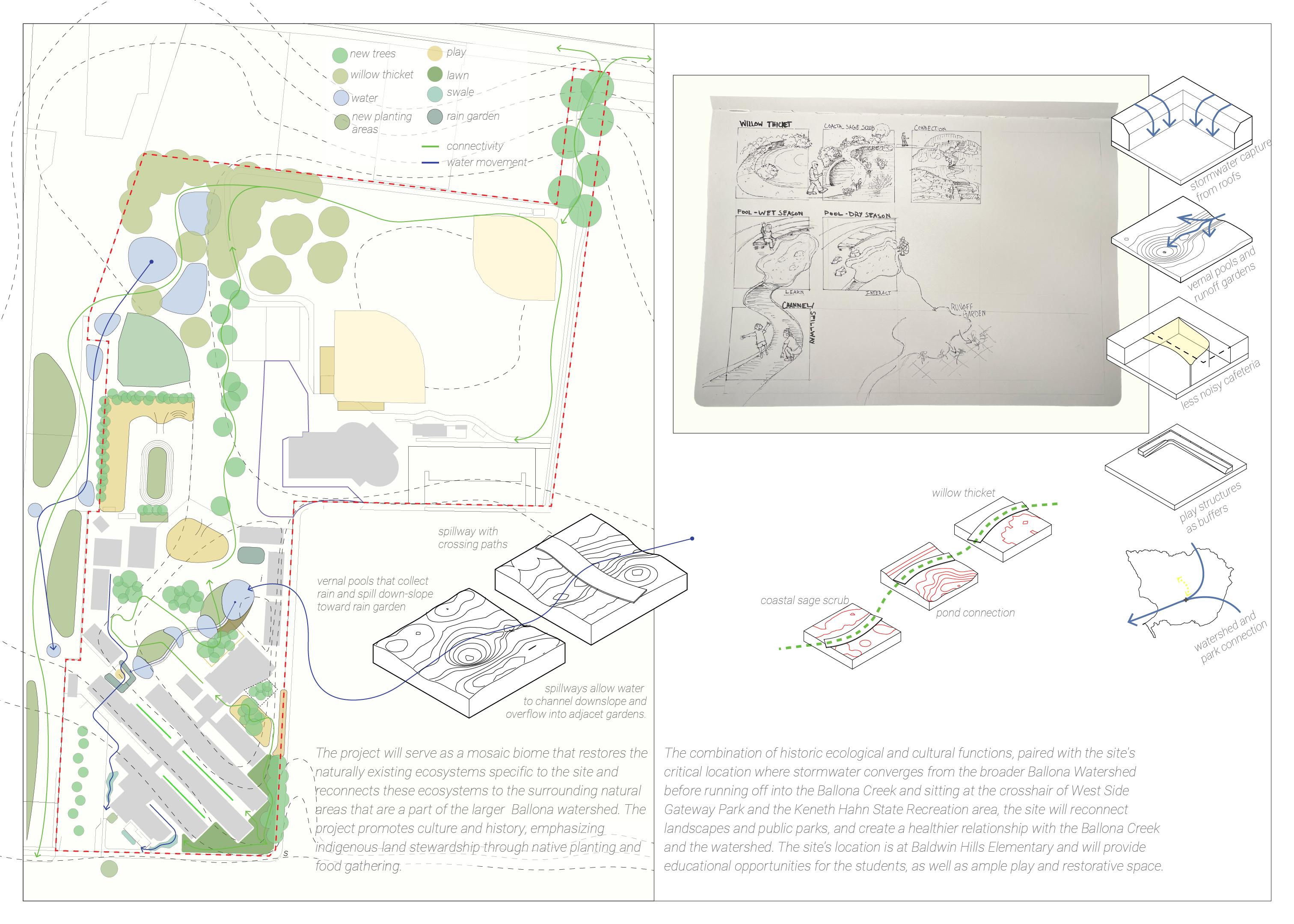
The ‘Return of La Cienega’ project is a schoolyard greening project rooted in watershed restoration. The name is inspired by the historic watershed conditions and ecology prior to European colonization and the mass urbanization that followed. What is now Culver City used to be a massive freshwater wetland mosaic with freshwater ponds, vernal pools, wet meadows, willow thickets and more. These wetlands were formed from ancient hydrological conditions where water would flow down stream from the Santa Monica Mountains, seeping through coarse soils, and travel above and below ground, settling at the base of the Baldwin hills.
The project attempts to mimic these watershed conditions by breaking the site up into multiple smaller watersheds, where water will flow into vernal pools, eventually spilling into a retention basin ‘wet meadow’ and captured by a cistern. Cisterns are located below mounded earth, mimicking the Baldwin hills where water flows and settles.
Project Goals
The goals of the project are layered:
1. Stormwater management
2. Habitat creation
3. Play, relax, learn
4. Community connection
The stormwater managment on site has been designed per City and County LID standards. The vernal pools will accomodate 35,734 cubic feet of water. This is used for both water capture and habitat creation. This leaves 96,418 cubic feet of water to be accomodated by cisterns which are located below mounded earth on site.
In addition, the project adds an additional mile of pedestrian pathway and two new entry points to the rec-center. This will create a 10 minute walk to a park for thousands of residents within surrounding high and moderate park need areas.
1. New entry from Jefferson Blvd 2. Vernal pools 3. Play mound/ground 4. Themed gardens
Yard pools 6. Lawn path/space
Oak woodland 8. Stormwater mound 9. Swales/play
Play mound
Adjacent path connection
Outdoor learning
Stormwater planters
cuts

To begin planning for site specific stormwater volumes, the project starts by fracturing the site into multiple watersheds based on the contour lines to calculate the Stormwater Quality Design Volume (SWQDv). According to the LA County LID Manual, the design storm is calculated using 0.75-inch, 24-hour storm event or 85th percentile, 24-hour storm event, whichever is bigger. The Manual suggests using HydroCalc, a stormwater volume software to calculate the site drainage basin(s) stormwater volume. HydroCalc, among other research was used to calculate the stormwater volume for a 100-year storm event (the maximum storm event on HydroCalc) for each watershed on site.


The Diagram above shows how the vernal pool and wet meadow system would work. The storm event flow path runs from the high point to the pools at the low point, filling up the forebay. The forebay was designed to accrue a 5 percent sediment intake per the LA County LID Manual. The remaining stormwater spills through a permeable gabion check dam into the main constructed pool. Depending on the stormwater volume calculated for a given watershed, there may be multiple pools to accommodate the design storm. The remaining water then overflows into a retention pond, or ‘wet meadow’ which filters through the soil, gravel and to a pipe. This water is then either directed to a cistern to use for irrigation or directed to the existing stormwater conveyance system. Each pool is designed with a wetland bench to accommodate wetland species (see full plant list in the appendix) and are designed per LA County and City LID Manual’s.
Cistern
stormwater carried to conveyance north of the site
Figure 33: Site Watershed Diagram
Figure 34: Hydrology Diagram


fairy shrimp Branchinecta sandiegonensis
Cat-eyed Western spadefoot toad Spea hammondii impermeable clay layer geomembrane liner
Figure 35: Section of Vernal Pools on the Field
Figure 36: Section of Vernal Pools on the Schoolyard

Oak Woodland
Vernal Pool
Wet Meadow Pollinator Garden
Vernal Pool Dry Season
Herb Garden


Wet Meadow Pipe
Figure 38: Oak Woodlands Perspective Section
Figure 39: Oak Woodlands Bloom Diagram


Pogogyne abramsii
Downingia cuspidata
Lupinus bicolor
Lasthenia californica
Psilocarphus brevissimus
Crassula aquatica
Distichlis spicata
Isoetes howellii
Eriophyllum confertiflorum
Carex praegracilis
vernal pool
Figure 40: Vernal Pools on Field Seasonality Render
Figure 42: Rec Center Playmound and Plaza Render
Figure 41: Vernal Pools Bloom Diagram
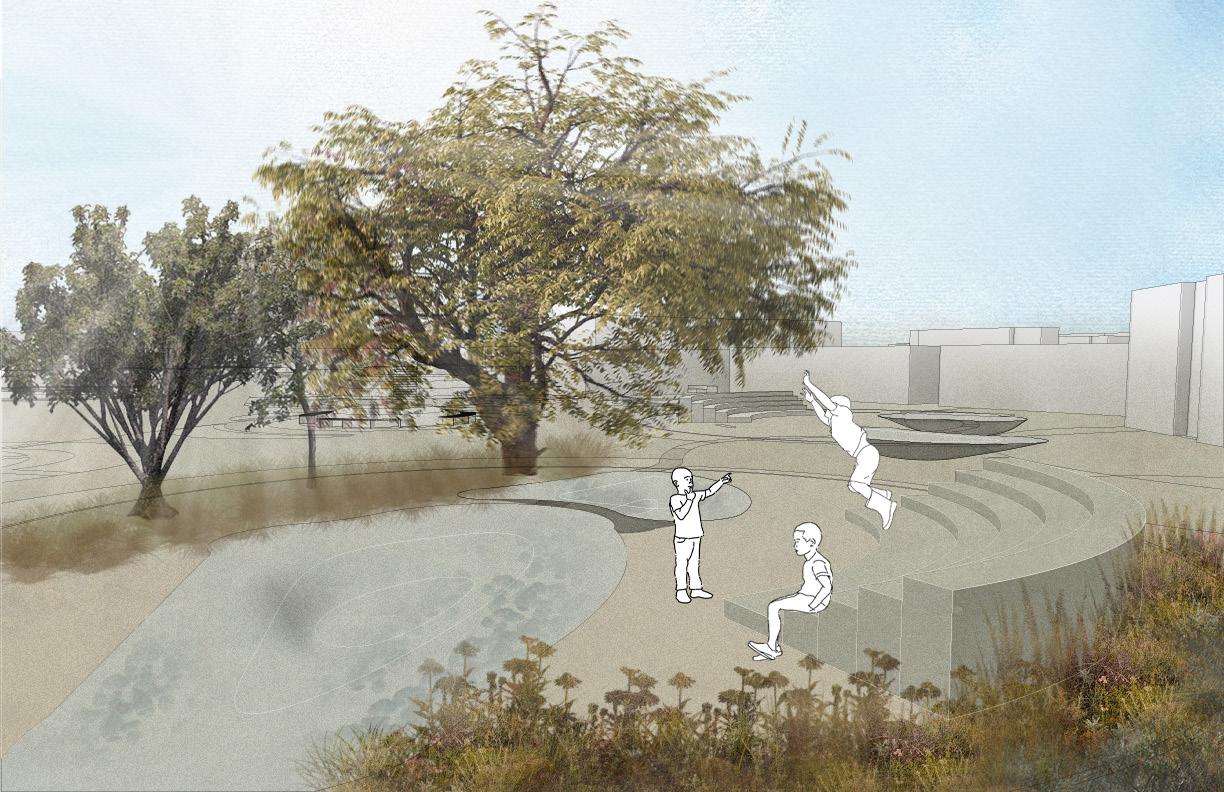

Figure 43: Schoolyard Render
Figure 44: Schoolyard Render

Appendix - Planting Pallet
Planting Pallet
Oak Woodlands
Coast Live Oak - Quercus agrifolia
• The most bio-diversity occurs when there is both multiple levels of vegetation heights and varied spacing between vegetation to create complex habitat structure both vertically and horizontally because there are more places for species that live in different layers of the vegetation.
• Coast Live Oak and California Walnut dominate the denser (over 30% cover), widespread woodland of the Coast Live Oak phase. Generally, this phase is found on the moister slopes, along fault lines, and by riparian areas within the district.
• California natives, such as Toyon and Manzanitas, are good “understory” plants for the Coast Live Oak. Fallen oak leaves provide natural mulch for the tree. Additionally, Oaks amend the soil over time with their own leaves and build the natural mycorrhizal fungus in the soil they need to thrive. Gradually, they provide natural fertility and improve the health of the nearby plants.
• Oak canopies can intercept 20-30 percent of annual rainfall
• The most diversity occurs when there is both multiple levels of vegetation heights and varied spacing between vegetation to create complex habitat structure both vertically and horizontally because there are more places for species that live in different layers of the vegetation.
• Low Density to allow annual native grasses to thrive
• grasses form in between oaks where there are shallower soils (creating vernal pools)
• Southern California Black Walnut (Juglans californica) (located closer to riparian areas/flow paths Understory or companion plants:
• Coyote Bush
• California Buckwheat
• Hummingbird Sage (frequently grows as an understory plant to native oaks and on grassy slopes in the southern oak woodland plant community)
• Coast Sagebrush
• Toyon
• California Coffeeberry
• Woolly Bluecurls
• Snapdragon Penstemon
• Fuchsiaflower Gooseberry
• California Wild Rose
• Manzanita sp.
• Ceanothus thyrsiflorus
• Sticky Monkey Flower
• Golden yarrow at opening
• Purple Needlegrass (Stipa pulchra) – helps baby oaks grow
• Holly Leaf Cherry
• Poppy sp.
• Chinese Houses
Wetland/ponds & pools (Based off San Diego Vernal Pool Region)
Dramatic, species-rich displays of wildflowers occur only where there are mild wet winters and hot dry summers. They occur in grasslands, woodlands, chaparral, and scrub. Plants that survive in vernal pools have special adaptations that allow them to endure the annual cycle of flood and drought. One of these adaptations is early germinations after fall rainstorms. Later, when the pool is inundated, some plants have the ability to pipe air to their roots through long, hollow stems or leaves. Others produce floating leaves which absorb enough air for the entire plant. The showy flowers—with species blooming in mass synchrony—attract a diverse abundance of pollinators. Fairy Shrimp survive here in summer drought by producing resting eggs or “cysts.” (Fremontia Journal Of The California Native Plant Society).
Annual Herbs and Wildflowers During Dry Season
• San Diego Mesa Mint
• Downingia cuspidata.
• Lupinus bicolor goldfields (Lasthenia)
Aquatic Plants
• Callitriche marginata
• astilleja campestris
• Crassula aquatica
• Distichlis spicata
• Howell’s Quillwort
Wet meadows/retention rain gardens
Plants for bottom of meadow
• Yerba Mansa
• Creeping Wild Rye
• Psilocarphus brevissimus var. brevissimus
• Trifolium variegatum
• meadowfoam (Limnanthes) (Likes the edge of the pool)
• popcornflowers (Plagiobothrys)
• button celery (Eryngium)
• Common Spikerush
• Clustered field sedge
• Basket Rush (Juncus textilis) (used by Tongva for basket weaving)
Plants for mid slope
• Distichlis spicata
• Clustered field sedge
• Mexican Rush
• Spiny Rush Yerba Buena
Plants for Top Slope
• Helianthus nuttallii
• Hummingbird sage
• Fragrant Pitcher Sage
• Common Yarrow (pollinator)
• California Polypody
• California Wildrose
• Eriogonum parvifolium
• Mugwort (indigenous use)
• California fuchsia (pollinator)
• Sticky monkey flower (pollinator)
• Scarlett monkey flower
• Blue Elderberry
Pollinator Garden Trees
• Holly leaf Cherry
• Blue Elderberry Shrubs
• Sticky Monkey Flower
• California Buckwheat
• Chaparral Mallow
• White Sage
• Bush Sunflower Herbs
• Scarlett Monkey Flower
• California Fuscia
• Golden Yarrow Herb Garden
• Chia Salvia columbariae
• Hummingbird sage
• White sage
• Woolly Bluecurls
• Artemesia Californica
• Common Yarrow
• Blueblossom Ceanothus Ceanothus thyrsiflorus


Bibliography
Latané, C. (2021). Schools that heal: Design with mental health in mind. Island Press. 2023 final report. Los Angeles Landscape History. (2023, November 15). https://lalandscapehistory.org/2023final-report/
Native plants of the Baldwin Hills Scenic Overlook. (n.d.). https://www.parks.ca.gov/pages/612/files/native_ plants_of_the_baldwin_hills_scenic_overlook.pdf
The southern oak woodland. California Southern oak woodland exists in many areas of inland Southern California. (n.d.-b). https://www.laspilitas.com/nature-of-california/communities/southern-oak-woodland
A Planner’s guide for Oak Woodlands. (n.d.-a). https://anrcatalog.ucanr.edu/pdf/3491E.pdf
Low impact development manual for Southern California: (n.d.-b). https://socalsmc.org/wp-content/ uploads/2019/07/SoCal-LID-Manual-2019-Update-2019-05-31.pdf
Vernal pools: Liquid sapphires of the Chaparral. Blog Page. (n.d.). https://californiachaparral.org/chaparral/ vernal-pools/
Artemisia: A journal by the California Native Plant Society. California Native Plant Society. (2023, November 24). https://www.cnps.org/publications/scientific-journal
CNPS. (n.d.). https://vegetation.cnps.org/
Coastal california rain gardens - anr catalog. (n.d.-b). https://anrcatalog.ucanr.edu/pdf/8531.pdf
California native herbs used for their medicinal, savory or aromatic qualities in gardens. California native plants used in herb gardens. (n.d.). https://www.laspilitas.com/classes/herbs.htm
Culbert, J. E. (2011, July 16). Native American uses of Southern California Vernal pool plants. tDAR. https://core. tdar.org/document/312432/native-american-uses-of-southern-california-vernal-pool-plants
Department of parks and recreation. Trails. (n.d.). https://trails.lacounty.gov/Trail/59/92-trail/ WhatYouMightSee/1035/toyon
Low impact development standards manual county of los ... (n.d.-d). https://dpw.lacounty.gov/ldd/lddservices/ docs/Low_Impact_Development_Standards_Manual.pdf
Low impact development standards manual county of los ... (n.d.-d). https://dpw.lacounty.gov/ldd/lddservices/ docs/Low_Impact_Development_Standards_Manual.pdf
Final budget 2023-24. (n.d.-c). https://www.lausd.org/cms/lib/CA01000043/Centricity/Domain/123/2023-24 Final Budget Book - 06.26.23.pdf
Historical ecology of the Ballona Creek watershed. (n.d.-d). https://www.urbanwildlands.org/Resources/TR_671_ Ballona%20Historical%20Ecology.pdf
YouTube. (2024, March 14). Schoolyard forest design lecture series 5: Stormwater schoolyards. YouTube. https://www.youtube.com/watch?v=e6vOX58buLA&t=1018s