
Urban Design Portfolio


Resume
Contact Information


912-996-1745
LinkedIn Profile Full Portfolio
chad.sharp1745@gmail.com
802 5th Ave N Seattle, WA 98109
Education
Kennesaw State University
College of Architecture and Construction
Five Year NAAB Accredited Bachelor of Architecture
2016-2023 Graduation
Work Experience
SharpSquared Photography Agency
Role: Lead Photographer, Client Consultant
Reference: Brandon Sharp 912-996-3116
2018-Present
Two Cameras and a Brush Event Agency
Role: Assistant Photographer
Reference: Taegen Dawkins 770-862-4766
2016-2019
Community Involvement
National Organization of Minority Architecture Students
2016-Present
Canvass for Stacey Abrams
Georgia House 89th District
2021-2022
Canvass for Raphael Warnock
Georgia Senator 117th Congress
2021-2022
Canvass for Representative Becky Evans
Georgia House 83rd District
2019-2020
Canvass for Representative Park Cannon
Georgia House 58th District
2019-2020
linkedin.com/in/ chad-sharp-architecture
Academic Awards
https://issuu.com/ chadsharparchitecture
First Place Urban Design Certificate of Merit Studio Competition 2022
Presented by Sizemore Group + Kennesaw State University
Research and Design Collaborative
Academic References
Ameen Farooq (Studio Professor)
Professor of Architecture at Kennesaw State University
Email: afarooq1@kennesaw.edu
Phone: 470-578-7263
Ermal Shpuza (Thesis Advisor)
Professor of Architecture at Kennesaw State University
Email: eshpuza@kennesaw.edu
Phone: 470-578-5134
Digital Skills
Photoshop
Illustrator
InDesign
Lightroom
AutoCad
Revit
Lumion
Enscape
Rhino
Sketchup
Grasshopper
Microsoft Office


Project I
Building Unity
Design Framework for Inclusive New Urbanism
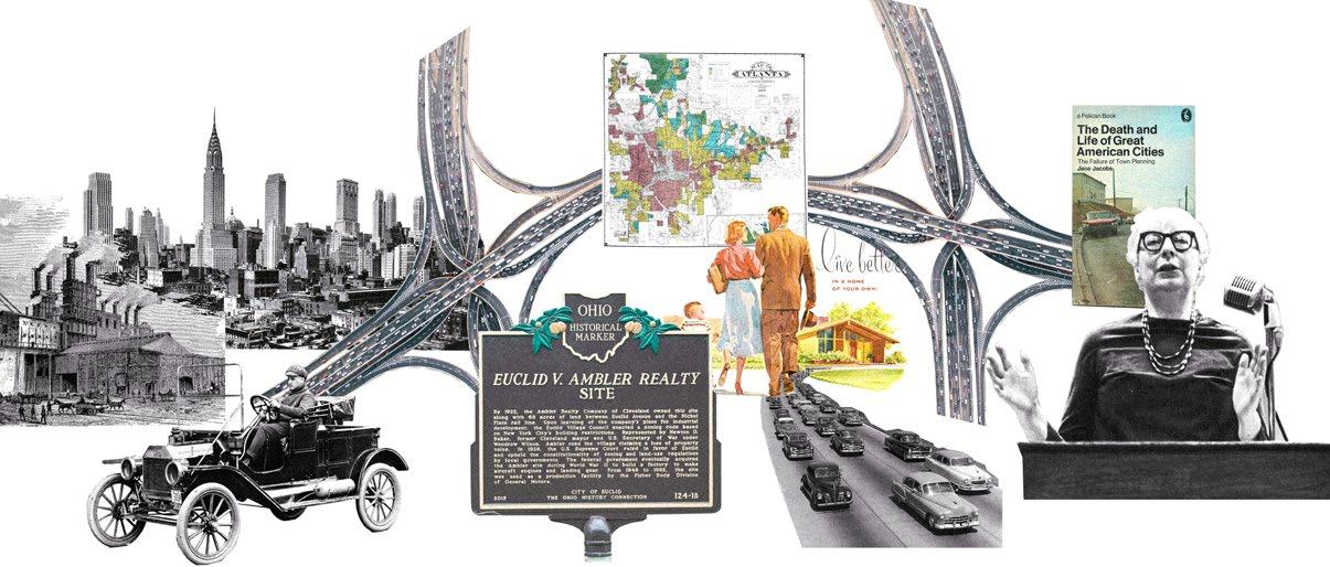
The City of Atlanta has historically embraced isolated growth over integrated density, which has contributed to the city’s limited inventory of inclusive urban centers. This divisive approach to urban design has helped facilitate a city of extremes, with regional concentrations of wealth and poverty. This circumstance is reinforced by the city’s inherently exclusive transportation network and isolated residential development patterns. As Atlanta continues to grow and densify, it is crucial to adopt planning and design models that prioritize high-density, mixed-use residential developments in equitable locations with easy access to public transportation. To account for the failures of property filtering and the rise of rapid gentrification, innovative design solutions should incorporate higher-density apartments that offer temporal flexibility in size through sub-division and merging. In her influential work, “The Death and Life of Great American Cities,” Jane Jacobs emphasized the crucial role of diversity in creating vibrant urban centers. Building upon her conceptual framework, and adapting it for today’s socio-economic context, future proposals should prioritize designs that promote an equitable, diverse, and ultimately more vibrant urban landscape.

Atlanta’s Exclusive and Inefficient Transportation Network
The Connectivity and Efficiency of Private and Public Transportation Options
Atlanta’s transportation system is inherently exclusive as car ownership and time become real barriers to entry for many of its most vibrant activity centers. Private Transportation is incomparably more efficient than public transportation both inside and outside the perimeter, and activity centers are not well connected to public transport.
Atlanta’s Isolated and Homogeneous Development Patterns


The Location and Diversity Score of New Residential Developments
Diversity Score Calculation
Minimum Value - Maximum Value
Maximum Value
Most new residential developments in the Atlanta metropolitan area are poorly integrated into the public transportation network. They also tend to score low on the diversity metric which assigns a score based on the value between the least and most expensive housing options in a singluar development.
“The Death and Life of Great American Cities” by Jane Jacobs
Jane Jacobs’ Conditions for Diverse Urban Centers
Condition I - Mixed Uses
Mixed Functional Uses
Mixed Temporal Uses
Eyes on the Street
Sidewalk Ballet
Mixed uses supply a continuous stream of locals and visitors that assure safety for everyone.
Condition III - Old Buildings
Variable Age
Variable Condition
Property Filtering
Organic Changes
Variable buildings should promote a greater degree of economic diversity among residents.
Condition II - Small Blocks
Small Size
Integrated
Orientation
Walkability
Circulation
Hierarchy
Small blocks and frequent streets with the proper orientation make for walkable neighborhoods.
Condition IV - Density
Density
Vibrant Culture
Vibrant Economy Concentration and density should promote a vibrant culture that supports the local economy.
The Conceptual Framework of the Jacobs Curve and Property Filtering
Diversity & Wealth Maximization
Conceptual Framework of the Jacobs Curve
Wealth
The “Jacobs Curve” illustrates the relationship between wealth and the diversity of households of various incomes. It is based on the assumption that spatial concentrations of either too little or too much wealth is unhealthy for urban centers. The idea is to create spaces where both wealth and diversity are optimally maximized.
Supports Lower Income Households and Businesses
New Construction (More Expensive)
Conceptual Framework of Property Filtering
Aged Buildings (More Affordable)
Supports Higher Income Households and Businesses
The primary way that cities acquire a variety of affordable housing options is through a process called property filtering, which dictates that as properties age, they tend to become comparatively less expensive than newer construction. In theory, this cycle naturally provides space for lower-income households within urban centers.
Updates for the Modern Context
The Failure of Property Filtering and Rapid Gentrification in Metropolitan Atlanta

This diagram reveals that like many other metropolitan areas in North America, Atlanta also follows a pattern where property in the city center filters upward, while the suburbs filters downwards. This process facilitates a city of extremes, with growing concentrations of wealth and poverty. Jane Jacobs work does not account for the rise of rapid gentrification which has prevented downward property filtering. Her framework must be updated for the modern context.
Original Concept
Modern Adaptation
Comprehensive Design Goals
As Atlanta continues to grow and densify, it is crucial to adopt planning and design models that prioritize high-density, mixed-use residential developments in equitable locations with easy access to public transportation. To account for the failures of property filtering and the rise of rapid gentrification, innovative design solutions should incorporate higher-density apartments that offer temporal flexibility in size through sub-division and merging.
Site Selection and Context Analysis


Building Unity; Design Framework for Inclusive New Urbanism
Compliment Existing Activity Nodes with New Connections
Create Sense of Place with Curvilinear Corridor Design
Unite People with Centralized Corridors, Parks, and Plazas
 Goal I
I
Goal III
Goal IV
Goal I
Goal II
Goal III
Goal IV
Bankhead’s New Walkable Mixed-Use District near Public Transit

Major Pedestrian Corridor Connects the Microsoft Campus and BeltLine Developments

Foster Community by Connecting People to Place
Districts Implement Regional Customization of Vernacular Aesthetics
The design proposal is characterized by two axes and four districts. Each district embraces an overarching theme that works to provide each region of the neighborhood with a variably distinct yet cohesive sense of place.


Foster Community with Quality Shared Spaces
Central Riverwalk Park and Plazas Unites People in Nature


While the East-West axis serves as a connective shopping corridor between the BeltLine and Microsoft Campus, this North-South axis works to center the proposal around Proctor Creek and the Bankhead MARTA Station.

Support Low Income Households with Flexible and Adaptive Design
Flexible Framework
Project III
Port City Redevelopment
Beirut, Lebanon
In the wake of tragedy this project looks to the design principles of historic Beirut to inform the path forward. By balancing economic and social aspirations the proposal successfully modernizes port operations while also affording city residents a more walkable and restorative lifestyle.


Context and Analysis
Neighborhoods Surroundings
Surrounding neighborhoods are culturaly diverse and have a wide array of architectural identities.

Boundaries of the site are met by three distinct regions of variable height, scale, and cultural dynamic.

Explosion Shockwave
Explosion was felt city-wide but damage was concentrated in the southeast. Concrete silos protected much of the southwest.
Urban Sprawl

Dendritic layout is a departure from historic planning strategies. It developed organicallly overtime with heavy reliance on vehicles.
Context and Analysis
Cultural Boundaires
‘Green Line’ historically divides the city between Muslims and Christians, marking a cultural boundary for locals.

Physical Boundaires
Large elevated highway and steep topological shift creates a potential access boundary to the site.
Access to the Coastline
Yellow marks loss of access to the coastline due to privitization. This creates an opportunity for access expansion.
Access to the Green Space
Orange marks loss of access to green space primarily due to rapid densification in the face of an ongoing housing crisis.

Southwest Context
Primarily mid to high rise commercial and mixed use developments. Wider avenues, larger block sizes, and an tall vertical condition.
Design Strategy
South Context
Primarily low to mid rise residential developments with a boundary marked by a wide vehicular highway and steep elevation change.
Southeast Context
Heavily damaged infrastructure. Unused industrial parks and landfills offer potential for expansion without penetrating urban space.
Southwest Response
Complementary extension to exsisting downtown region. Integration of new public amenities with the addition of shared streets.
South Response
Use historic urban planning strategies that prioritize density at a human scale. Mixed used residential developments with shared streets.


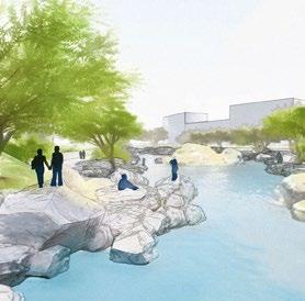
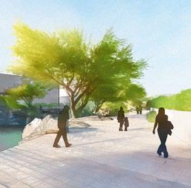
Unifying Waterfront Promenade
Southeast Response
Localize port operations with safety buffers at its edges. Expand operations to the meet growing capactiy needs of 21st century.
design scheme adapts to its surroundings and varies across the site to reinforce a optimally variable yet cohesive experience

Design Strategy and Proposal


Design Realization
Maintaining a 90-degree angle across the irregular coastline was a key design constraint in order to optimze block geometry for developers. Regions where the grid scheme warped became opportunities for integrating public amenities such as parks and civic spaces. Historic urban design strategies are implemented through the scale and geometry of the new grid. In the central district, 45-degree angle sub-divide typical blocks to create pedestrian corridors. These corridors converge at activity nodes along the coastline. The coast is activated with public amenities such as parks, beaches, and a unifying waterfront promenade.
 Memorial Park Event Stadium Dowtown Waterfront Park
Unifying Waterfront Promenade
Cruise Ship Terminal
Interior Linear Park
Waterbreaker Park Extension Sailboat Marina Beach Activities
Memorial Park Event Stadium Dowtown Waterfront Park
Unifying Waterfront Promenade
Cruise Ship Terminal
Interior Linear Park
Waterbreaker Park Extension Sailboat Marina Beach Activities
Creating Neighborhoods


Development outlook would ideally distribute essential public amenities within each block cluster to afford its residents a walkable lifestyle. The design scheme estabishes an thoughtful framework on which the city can develop itself. The culmination of integrated green and civic spaces are complimented by a clear street heirarchy. Pedestrian corridors become areas for walkability, leisure, and merchant operations. Healthcare, education, and shopping facilities should aim to be within walking distance.

Connection to the Coastline


Beachfront Waterfront


