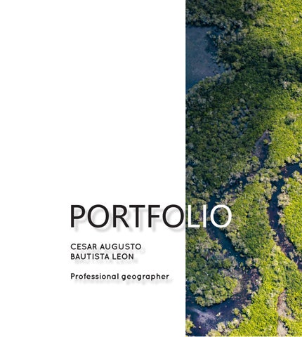
César Augusto Bautista León Professional Geographer
Curriculum Vitae
WORK EXPERIENCE
2023 December - 2024 December
GIS researcher in the Deforestation Drivers Analysis, Law Enforcement and Traceability team of the Foundation for Conservation and Sustainable Development (FCDS). Compilation and structuring of geographic information on the dynamics of cattle ranching, illicit crops and oil palm plantations, as well as their environmental impacts on connectivity, fragmentation and forest degradation.
Bogotá D.C., Colombia.
2022 January - 2023 October
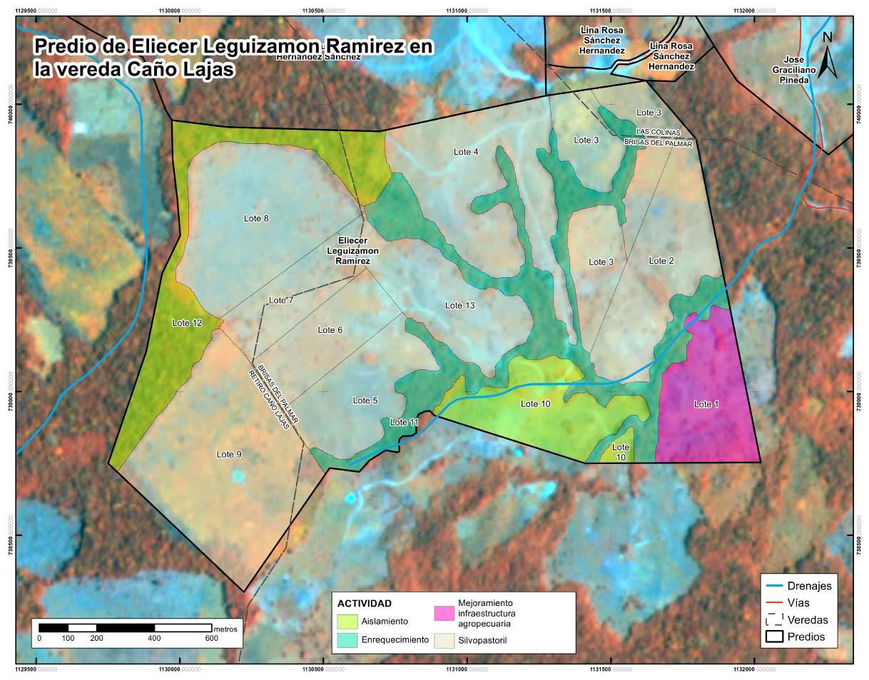
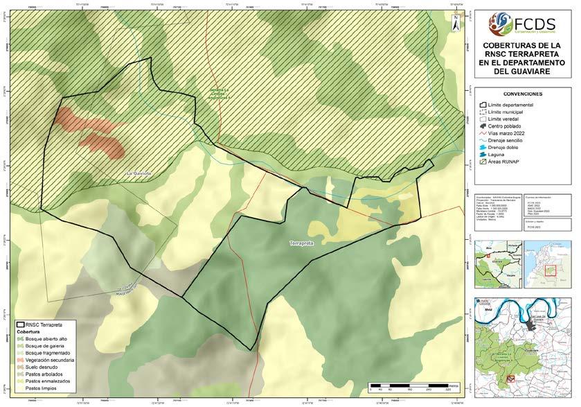
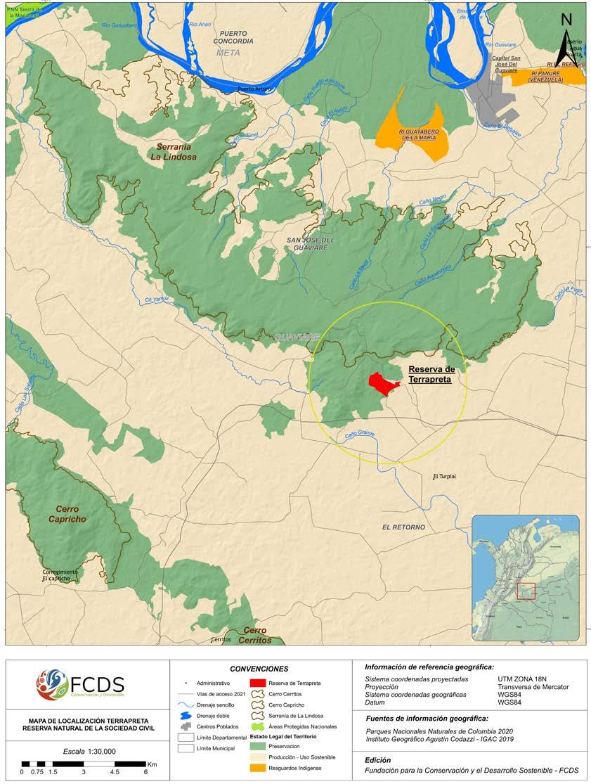
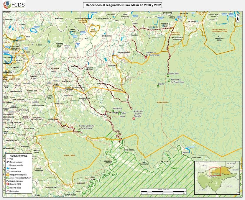
GIS professional in the Community Forestry Program of the Foundation for Conservation and Sustainable Development (FCDS), department of Guaviare. Monitoring of forest restoration and conservation projects, analysis of ecological connectivity in land owned by rural families, support for initiatives to reintegrate the Nukak indigenous community to their reservation and support to formulation of the Terrapreta Natural Reserve and its respective ecological restoration strategies.
San José del Guaviare, Guaviare, Colombia.
2022 December - 2023 January
GIS professional in TERRASOS, Habitat Bank of the Matarredonda Civil Society Natural Reserve, department of Meta. Thematic cartography, defining the project area, identifying potential areas for the presence of the Seje palm (Oenocarpus bataua), delimitation of land involved in the project area and potential areas for connectivity and ecological restoration.
San Martín, Meta, Colombia
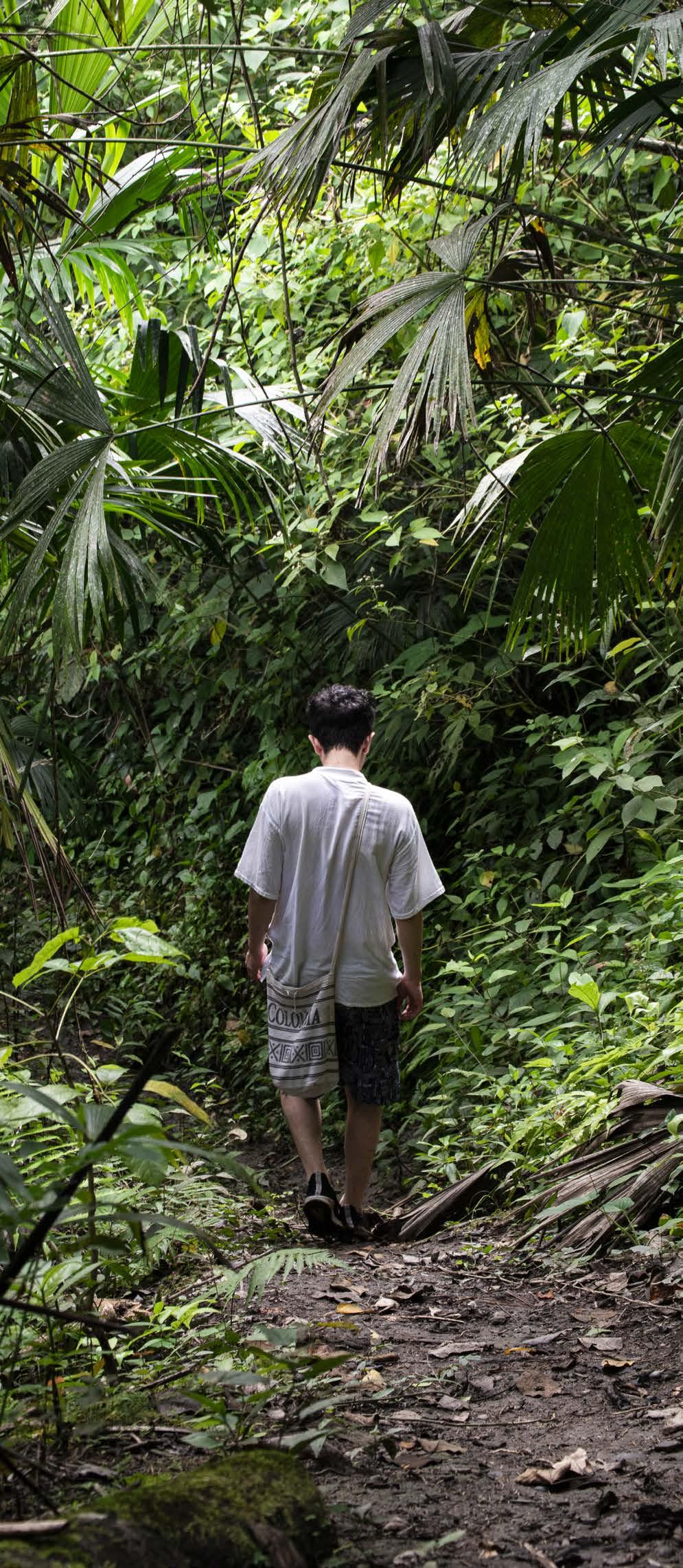
La Vega, Cundinamarca, Colombia, taken by Angie Camacho, 2021
2021. February - December
GIS professional at the Foundation for Conservation and Sustainable Development (FCDS), Bogotá. Structuring and creation of geographic information and territorial analysis of environmental pressures on the Colombian Amazon National Parks, analysis of ecological connectivity for focal species of the Colombian Amazon Rainforest, Support to the formulation of the Green Road Infrastructure guidelines with the pilot project in the department of Guaviare. Bogota, Colombia.
2020 April - July, 2020 September – November Bogota Spatial Data Management Assistant. Structuring of geodatabases, analysis of mobility networks of Bogota and spatial analysis of crime and residential complexes in the city of Bogota, within an academic research of Angie Carolina Camacho Gutiérrez, Architect and Master in Integrated Urbanism and Sustainable Design.
Bogota, Colombia.
BACHELOR’S DEGREE
2015 - 2020. Geography. National University of Colombia. Bogota, Colombia.
OTHER COURSES
2024. Mapping with R: From static to dynamic Virtual course of 34h at Pontificia Universidad Javeriana. Bogota, Colombia.
2020. Local Climate Change Mitigation and Adaptation. Short virtual course at the National Training Service (SENA). Bogota, Colombia.
2019 Climate Change. Virtual course at the Centre for Climate and Resilience Research (CR)2 at the University of Chile, University of Concepción and Austral University of Chile. Bogota, Colombia.
2018 Conceptual bases of the Forest and Carbon Monitoring System (SMByC) as a support for information management on Colombia’s natural forests. Virtual course of the Institute of Hydrology, Meteorology and Environmental Studies (IDEAM). Bogota, Colombia.
2008 – 2013
High school. District Educational Institution Villemar el Carmen. Bogota, Colombia.
LANGUAGES
Spanish Native language
English C1 according to TOELF score (96) French A2 noncertified
SOFTWARE
Microsoft Office Suite Word
Adobe Creative Suite
Photoshop
InDesign
Geographical Information Systems GIS
ArcGis
QGis
Fragstats
MaxEnt
R Studio
Others
KoboCollect
PERSONAL INTERESTS
Environmental geography, ecology and conservation of tropical ecosystems, geographic information systems, spatial analysis and modelling. Nature photography, hiking, cultural exchanges.
Deforestation Drivers Analysis and Traceability Team. 2024
The Deforestation Drivers Analysis, Law Enforcement and Traceability Team is a research group of the Foundation for Conservation and Sustainable Development (FCDS for its acronym in Spanish) that seeks to analyze how productive activities, whether legal or illegal, directly or indirectly contribute to deforestation and land use change in the Colombian Amazon and other environmentally important regions of the country, in order to subsequently support decision-makers on issues of conservation of the Colombian environment.
The research carried out by this team is developed within different spaces and methods of approach. As an analyst and researcher of the geographic component, I have participated in the analysis of the impacts of livestock production in the forest of the departments of Meta, Guaviare and
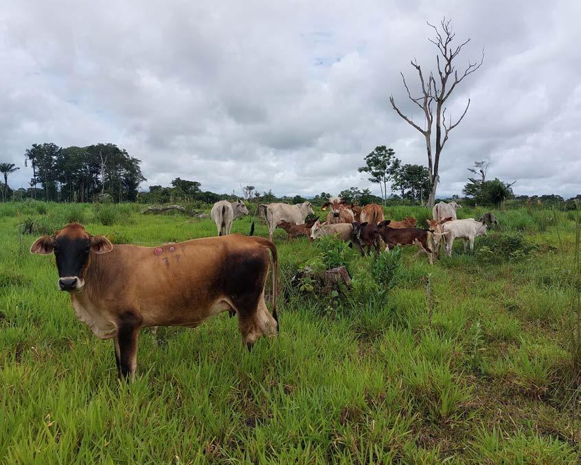
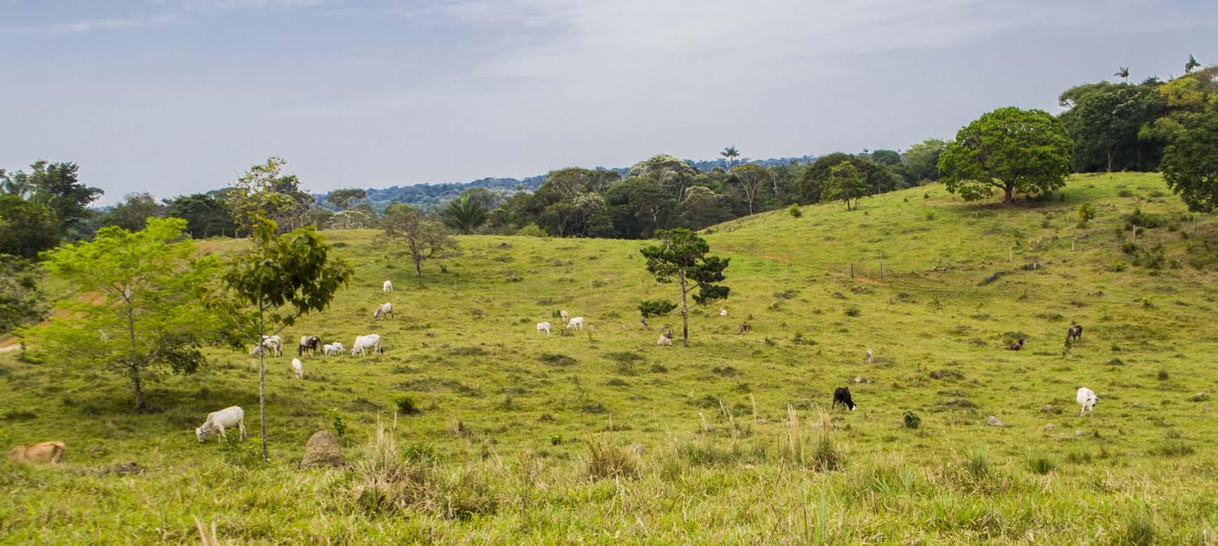
Cattle near the Serranía de Chiribiquete National Natural Park in the department of Guaviare.
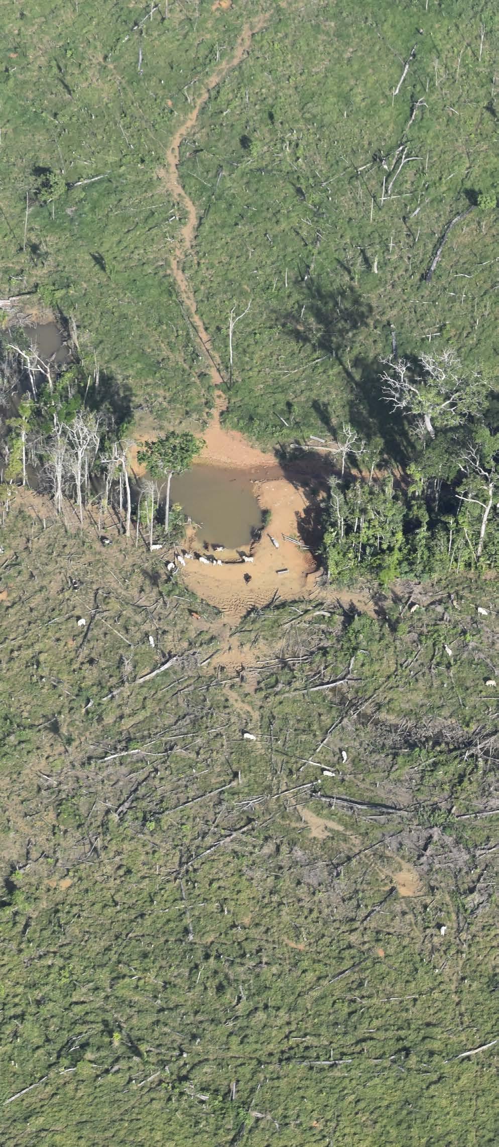
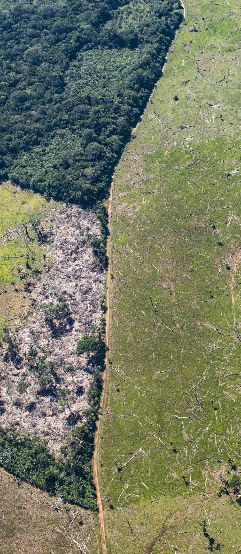
Deforestation due to livestock activities in Guaviare taken by Cesar Bautista, 2022
Caquetá; the impact of coca crops on the National Natural Parks of Colombia and the implementation of European Initiative on Deforestation-free Value Chains.
Recent research by the Deforestation Drivers Analysis Team with support from the UK Embassy entitled Cattle Ranching as a Driver of Deforestation: Enabling Conditions and Territorial Dynamics in Guaviare shows how deforestation of Amazon forests is closely related to cattle ranching practices, land grabbing and income from illegal economies. The research focused on four zones in the department of Guaviare that stand out for their deforestation and cattle numbers near areas of special environmental importance. The results of this research were presented in the debates in the Senate of the Republic on the law project that aimed to guarantee deforestation-free cattle ranching in Colombia.
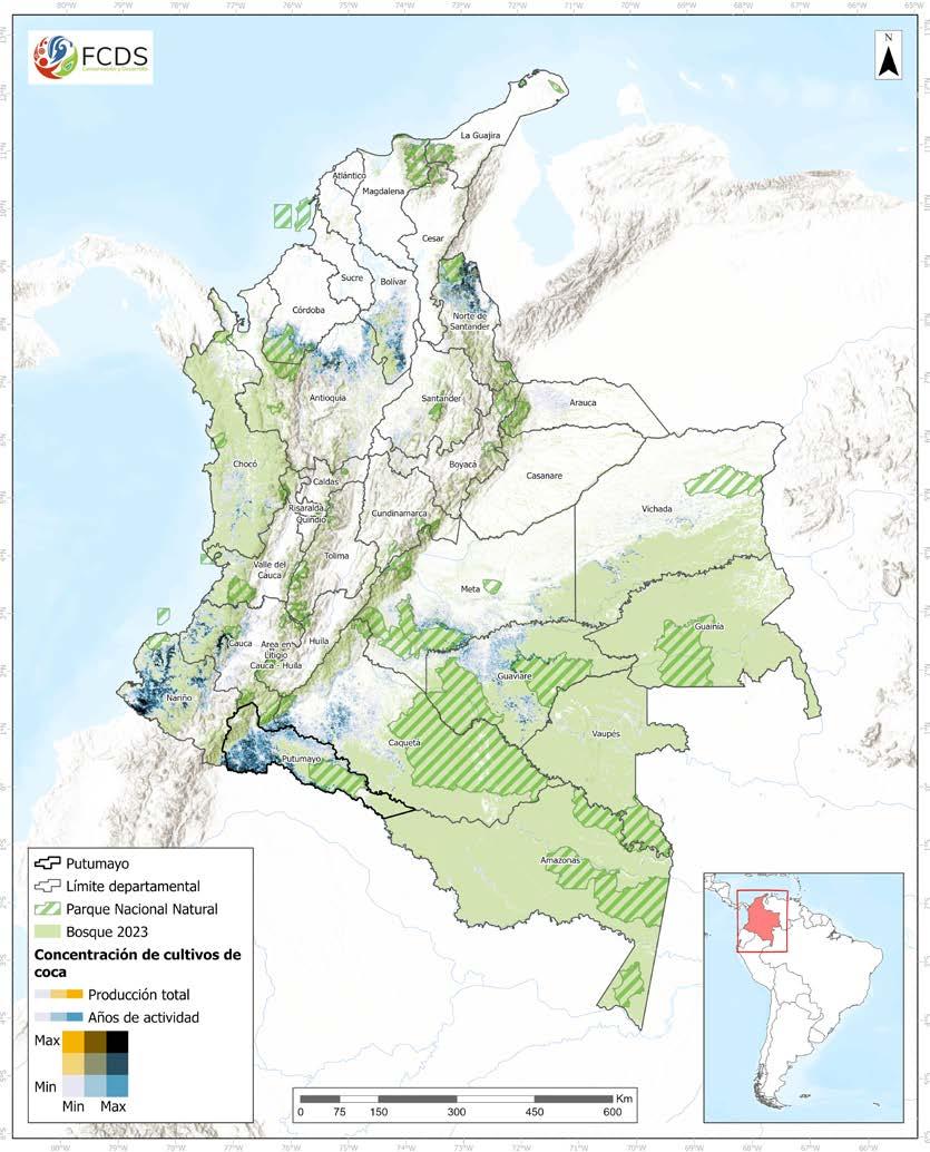
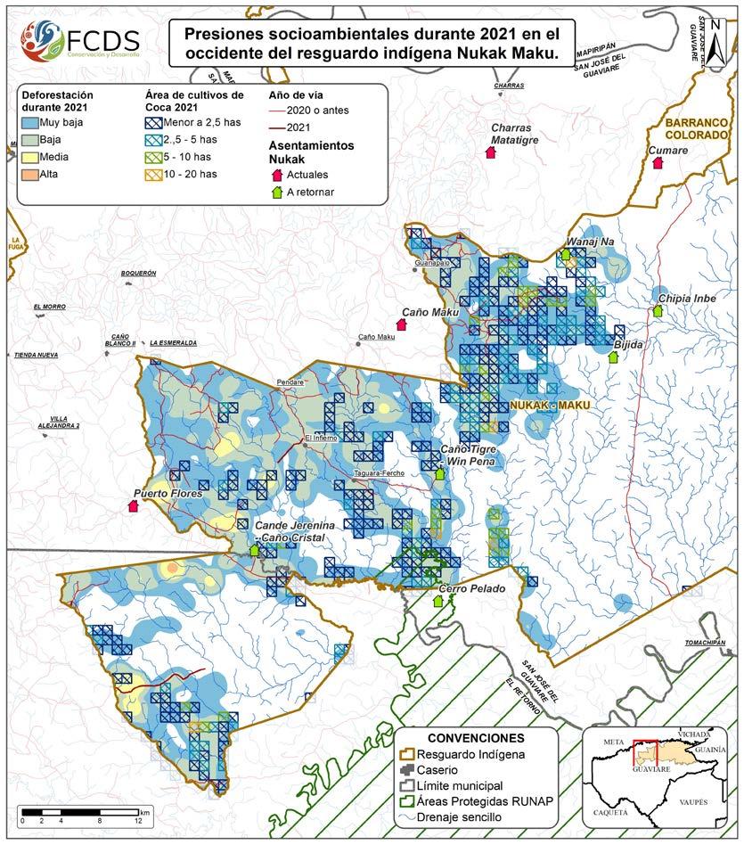
On the other hand, the Colombian Amazon is home to several hotspots of coca cultivation in the country, associated with La Paya National Park, Sierra de la Macarena National Park and the Nukak National Nature Reserve. Although the coca activity has presented an economic crisis in recent months, these hotspots do not seem to cease their activity and represent a long-term risk: with the socio-political
pressures of substitution and eradication of the plant, farmers and producers migrate to other economies such as livestock or mining, impacting even more on the Colombian natural ecosystems. In that sense, this research team seeks to contribute valuable information about forest transformation, the impact on connectivity and fragmentation of these protected areas to the management and protection organizations of Colombia’s National Natural Parks.
Finally, we have accompanied socialization exercises and advice to various social and business associations that want to comply with the Europe Initiative on Deforestationfree Value Chains for the Meat, Milk, Cocoa and Coffee value chains, since the investigations of the team have made it a reference for monitoring the impacts of these and other economies.
Coca crops in the Nukak National Nature Reserve , Guaviare
Spatial relation between illicit coca cultivation and deforestation in Colombia.
Foundation for Conservation and Sustainable Development - FCDS
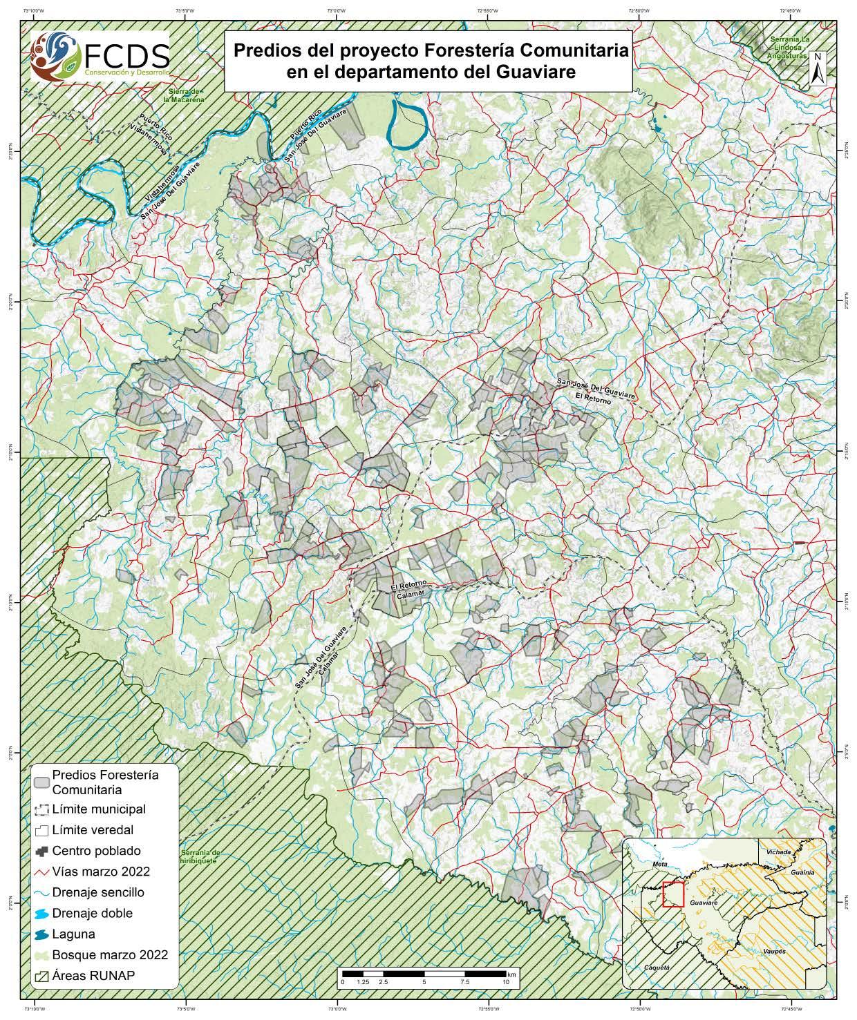
Community Forestry Program. 2023
The Community Forestry Program is developed in direct influence of the Serranía de Chiribiquete National Natural Park (PNN) with funding from the Norwegian Embassy and the United States Agency for International Development (USAID). The program currently has more than 300 users located in 32 villages, grouped in three sectors: Asocapricho, Cristalina and Guayabero. The program is carried out in the department of Guaviare in conjunction with the Community Action Boards of each community. The Community Forestry program includes the Productive Forest Initiative (IBP by its Spanish initials), which
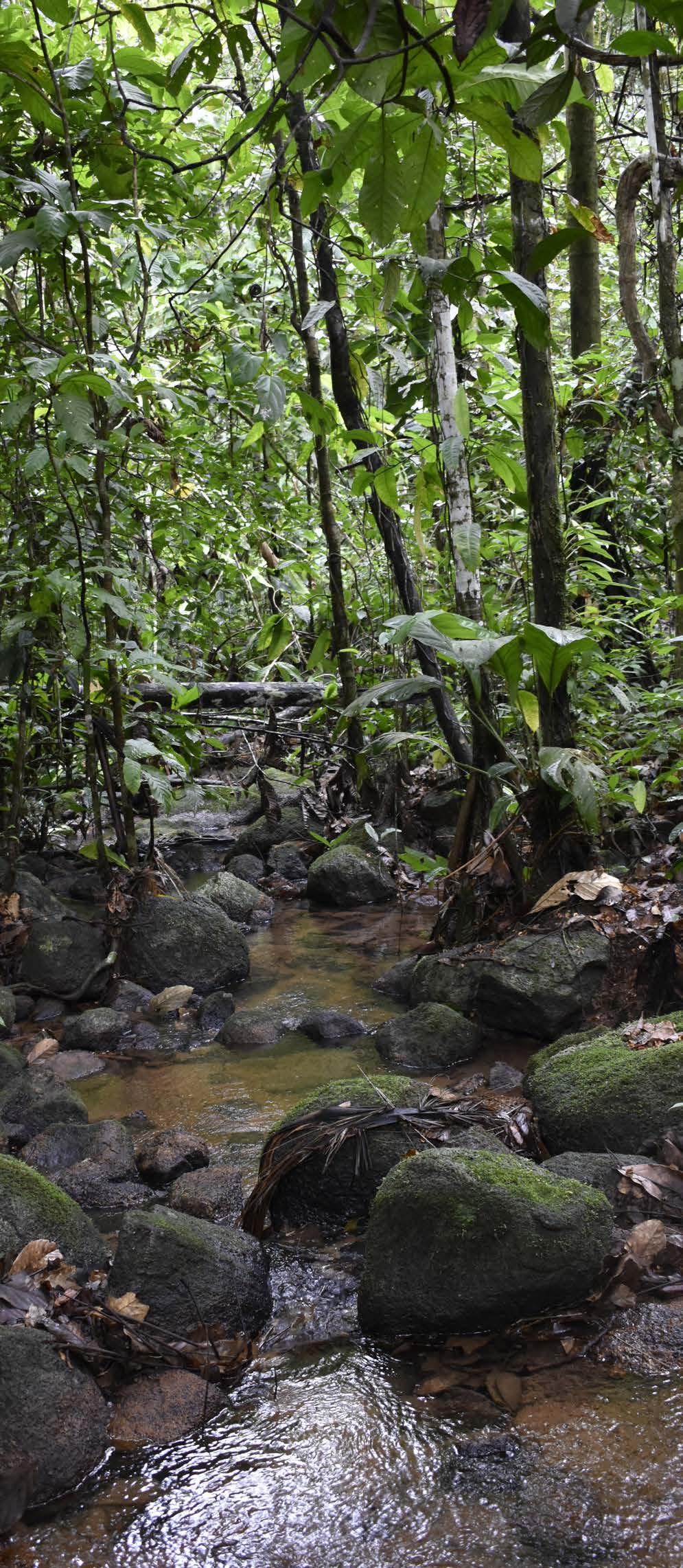
Stream on beneficiaries land from Community Forestry, Guaviare taken by Cesar Bautista, 2022
User lands of Community Forestry project in the department of Guaviare.
seeks to improve the ecological conditions of the properties of peasant families and thus generate economic benefits based on the conservation and restoration of the forest. This initiative consists of family projects to enrich the forest with native species, division of pastures with fences with fruit species also called living fences, agricultural plots for food safety, support for agroforestry systems, community nurseries, community ecotourism, and beekeeping with stingless bees.
For the efficient development of the project in the Guaviare department, the Sustainable Land Planning strategy (PPS by its initials in Spanish) decreed by the Guaviare Governor’s Office was adopted. This strategy consists of characterizing the lands and families in the rural areas of the region to implement territorial planning based on the needs of the families, the characteristics of the property and the areas with conservation potential, all for a period of twelve years.
The Community Forestry program seeks to expand the proper management of natural resources through a comprehensive intervention and the reconversion of productive systems that reduce deforestation processes and promote the use of forest and non-forest resources. In this way, the PPS is a platform where Community Forestry can be integrated into the life plan of its beneficiaries,
thus involving women and young people in the management and improvement of their land.
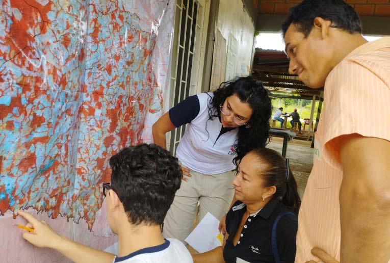
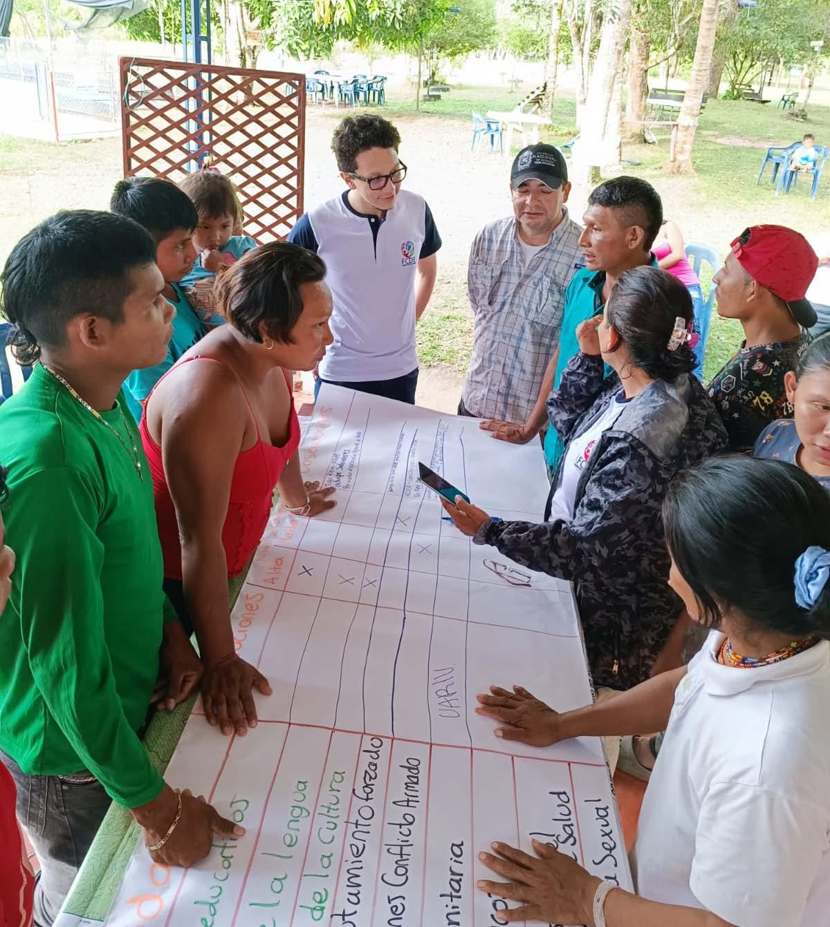
Among the most significant contributions to the Community Forestry program from the management of Geographic Information Systems (GIS) are the consolidation of a unified database of the Productive Forest Initiative (IBP) projects and their follow-up within the properties, for which the technical team was trained in the use of mobile data collection tools such as Kobo Collect and Avenza. Likewise, for the PPS strategy, social mapping workshops were held to complement the information on property boundaries and coverage, which was enriched with information on land use, potential use of the land and zoning of the property in accordance with the action plan agreed upon by the landowners.
Finally, an evaluation of environmental factors was conducted in the properties that are part of the Management Plan and Forest Use of Asai (Euterpe precatoria) and Seje (Oenocarpus bataua) in El Capricho Village in San José, as well as an analysis of the potential distribution of Inchi Cacay (Caryodendron orinocense) in the 32 villages.
Sustainable Land Planning workshop with peasant families in Calamar, Guaviare
Sustainable Land Planning cartography of a Community Forestry project user land.
Foundation for Conservation and Sustainable Development - FCDS
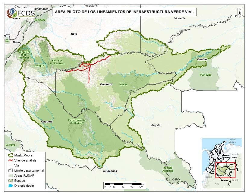
Green Infrastructure Guidelines for Roads (LIVV). 2022
The Interministerial Environmental Agenda established by the Ministry of Environment and Sustainable Development and the Ministry of Transportation includes in its action plans the prevention and management of conflicts between road infrastructure and the conservation of biodiversity and its ecosystem services through general regulations that can be adopted in the development of green infrastructure, the Green Infrastructure Guidelines for Roads (LIVV by its Spanish initials).
In order to define these guidelines in road infrastructure planning, an analysis and implementation pilot was developed in the Guaviare department, specifically in four important road axes in that area: San José- El Retorno - Calamar Road, San José - Charras road, San José - Puerto Cachicamo road, Perimetral de la Lindosa road.
Deforestation related to roads in Guaviare, Colombia, taken by César Bautista, 2021
Pilot area for Green Infrastructure Guidelines for Roads.
These roads were selected because they are axes of regional mobility that allow connectivity between villages and the capital, in addition to being related to important conservation areas such as La Fuga savannas, the National Natural Parks (PNN by its Spanish initials) Serranía de Chiribiquete and Sierra de la Macarena, among others. To identify the sections of potential intervention to improve the ecological connectivity of these roads, a connectivity corridor model was developed for an area larger than Guaviare, covering the entirety of the Serranía de Chiribiquete, Sierra de la Macarena and Tinigua PNNs, as well as the border of the Amazon biome in southern Meta and part of the Yarí savannas in the region of Caquetá.
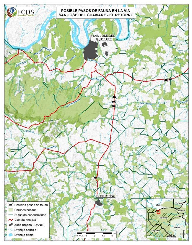
The analysis was based on surveys and collection of samples of ten focal species of fauna, which allowed us to define the parameters of the connectivity model based on the habitat requirements of the species. Thus, based on the frequented coverage, distribution, and habitat area of each species, three groups were defined for the model, which included the creation of variables such as biomass index, fragmentation index, distances to cover and strategic areas, population density, among others.
The implementation of tools and strategies based on Geographic Information Systems
(GIS) made it possible to carry out a highvalue study for the analysis of ecological connectivity in Guaviare. With this input it was possible to define important points on the roads to establish wildlife crossings. Both civil organizations and government agencies have made use of this information to include it in territorial management plans and exercises, giving the study a great social and institutional scope.
On the other hand, including connectivity analysis and studies of this type is a crosscutting element in the LIVVs, which is already part of the early stages of road connectivity projects. In this sense, during the last stage of the project, the results of the connectivity assessment were laid out and delivered to the communities involved in the project and to the ministries that are beginning to adapt the LIVVs in the planning of their projects.
Socialisation of connectivity corridors in La Carpa village, San José del Guaviare.
Potential wildlife crossings on the San José del Guaviare - El Retorno road.
National University of Colombia
Cattle
ranching in the Amazonian agricultural frontier and greenhouse gas emissions, case of the Guaviare department, Colombia. 2020
Degree thesis presented by César Bautista to obtain the degree of Geographer. Directed by José Daniel Pabón Caicedo PhD. The Guaviare department is located in the north of the Colombian Amazon, where cattle ranching has contributed to deforestation, making Guaviare the department with the third highest rate of forest loss in the country, a problem that has worsened since 2016 after the peace agreement that led to the disappearance of territorial control exercised by the armed group Revolutionary Armed Forces of Colombia – People’s Army (FARCEP by its initials in Spanish) and subsequently to the arrival of large land grabbers due to the lack of state presence. However, this problem goes beyond and is framed in the global context of Climate Change.
To understand this, an analysis of the cattle activity of Guaviare department and mainly its capital municipality, San José, has been carried out, in which issues such as the arrival of cattle in the region, the current cattle system, its contribution to deforestation and forest conversion, the consequent emissions of greenhouse gases and possible measures at the hand of the State and the population to address this growing phenomenon have been addressed. This research was developed as an undergraduate thesis for the degree of Geographer at the Universidad Nacional de Colombia (Bogotá) and was directed by Professor José Daniel Pabón Caicedo,
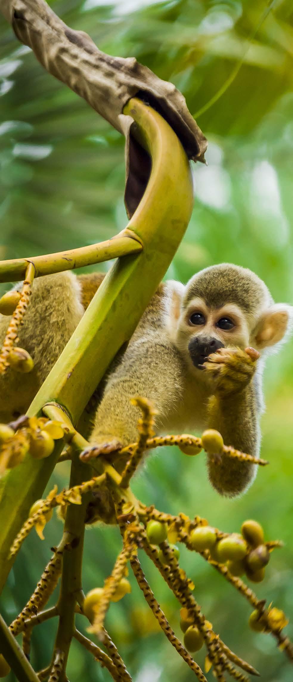
Squirrel Monkey, in Guavaire, Colombia taken by César Bautista, 2020
PhD. The development of the research was characterized by a mixed methodology, in which quantitative and qualitative techniques were used. Thus, processing and interpretation of spatial data, analysis of historical figures, correlation between different variables, among other exercises performed, are framed in quantitative methods. On the other hand, exercises such as the analysis of the relationship among the different communities with cattle ranching and with the Amazon biome, based on the review of background information and interviews with the different actors, in addition to the compilation of information found in the different reports and media that have addressed related topics, make up the qualitative strategy.
The research consisted of five stages: historical and social recognition of Guaviare, economic and population related activities,
fieldwork in rural areas of the department, identification of the cattle system and environmental problems related to cattle, estimation of GHG emissions associated with cattle, and formulation of proposals for climate change mitigation.
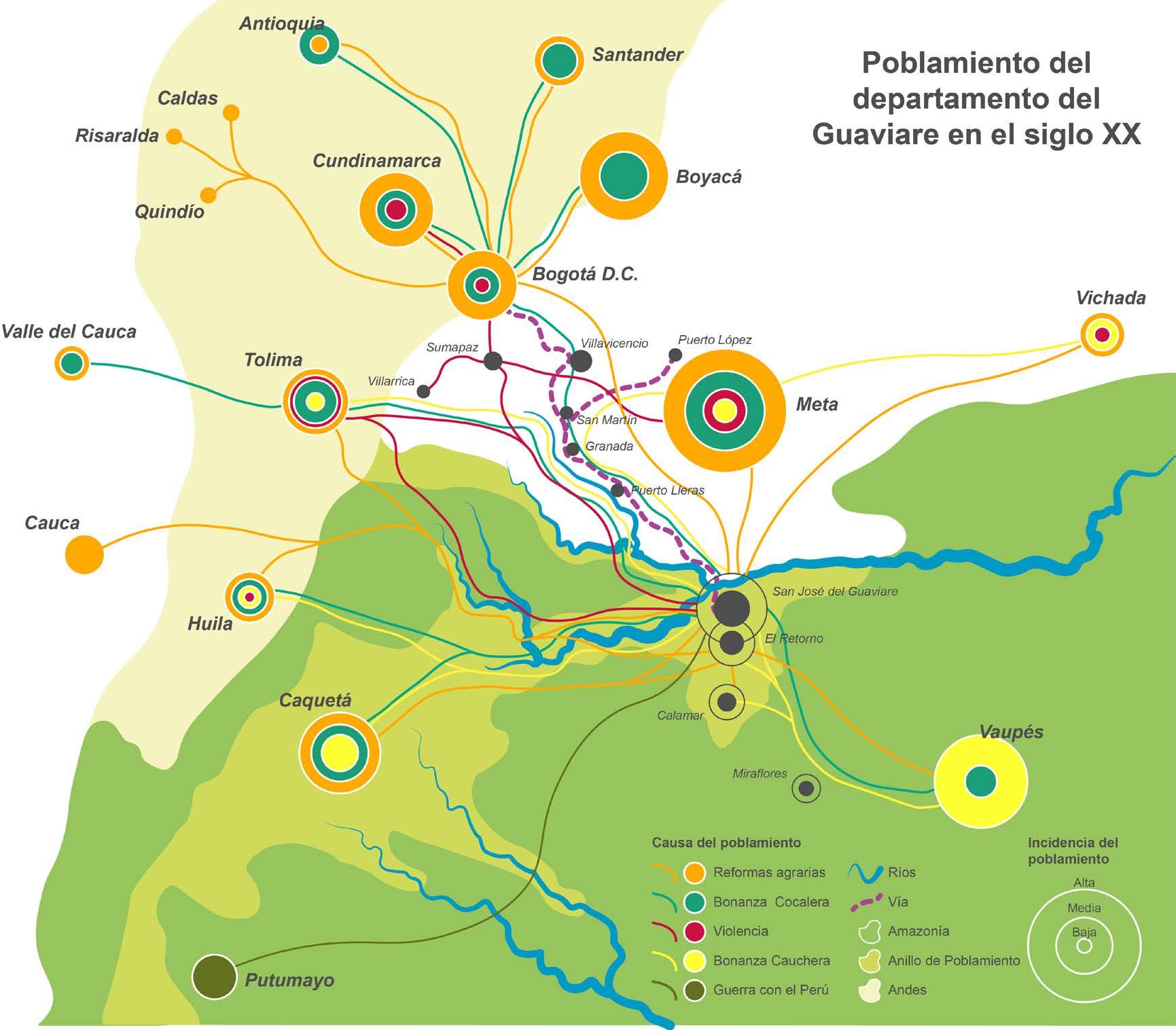
Initially, the historical recognition was focused on the analysis of the region’s population. The predominant economic activities throughout the last decades and a brief list of the actors involved in these activities were presented, which allowed identifying four causes of the settlement in the region of Guaviare: rubber exploitation from the beginning of the 20th century until the 1940s,”La Violencia” (The Violence period) between the 1940s and the 1970s, agrarian reforms from the 1930s to the 1980s, and illicit crops from the 1970s to the beginning of the 21st century.
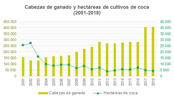
Since the arrival of coca cultivation in Guaviare in the 1980s, the region has become a major producer of this illicit crop. From 2000 to 2002, Guaviare went from 17,619 hectares to 27,381 hectares of coca cultivation, thus increasing the area at the national level from 10.8% to 26.8%. This
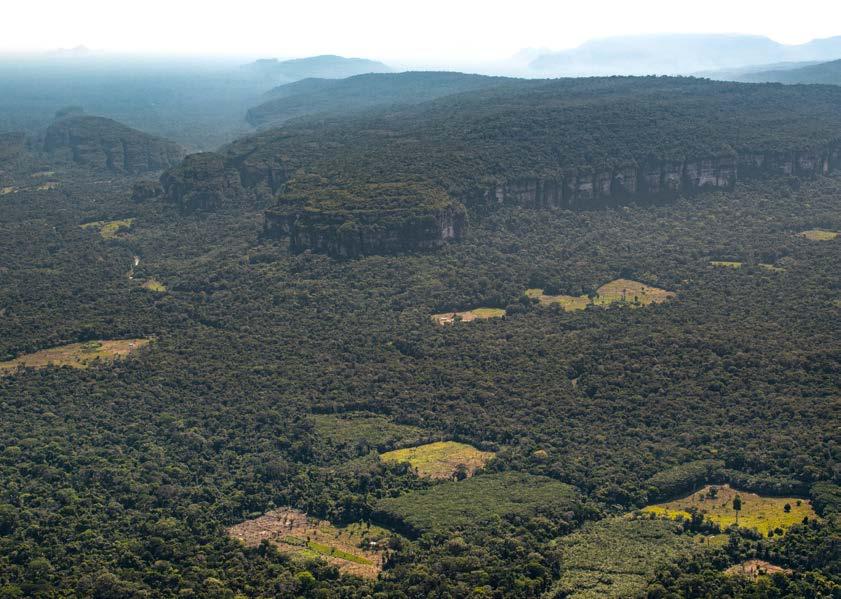
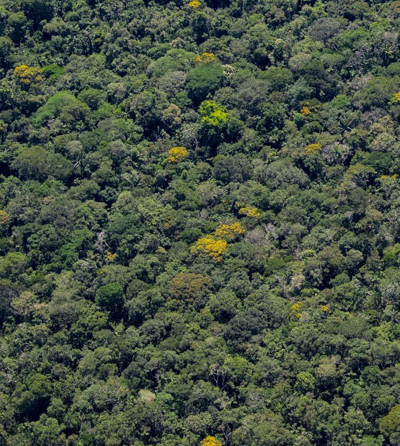
Amazon forest in Guaviare departament.
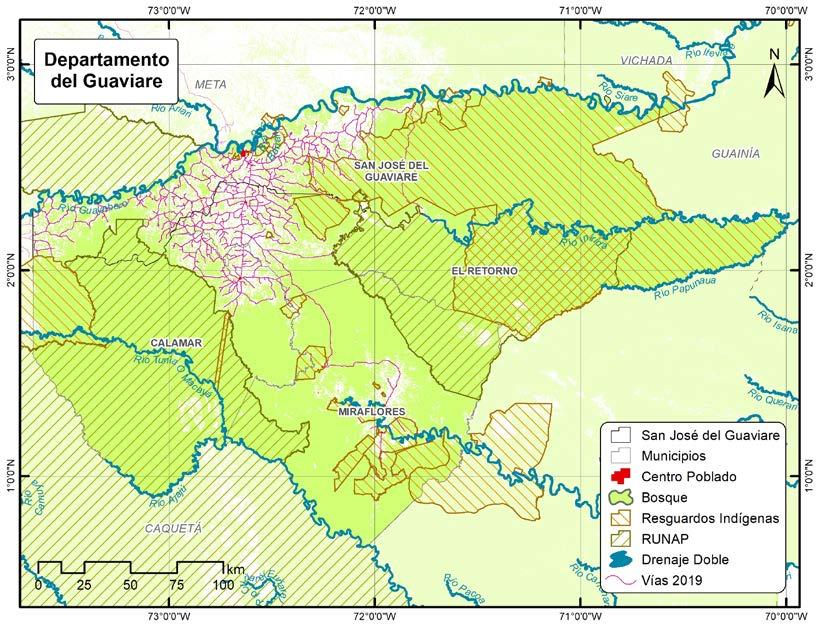
Guaviare department, in the north of the Colombian Amazon.
increase was caused by the displacement of production from the region of Putumayo, where a strong eradication campaign by aerial spraying was carried out. In the following years, production of these crops moved to regions such as Nariño, Cauca, Norte de Santander. Crop reduction programs through voluntary and forced eradication as well as the Program for the
Eradication of Illicit Crops with Glyphosate were present in Guaviare; Gladis Romero recalls how in the mid-2000s this program indirectly boosted the increase of cattle in San José del Guaviare:
Gladis Romero: “From the coca we already had a little bit of cattle and since we had pasture, our friends who had a lot of cattle
Settling of Guaviare department in the 20th century.
also started to give us cattle from the increase and to stop cultivating the crops it was because they sprayed with the airplanes and we had to finish Guaviare because there the airplanes came to spray and burn the pastures, so they burned the pasture and the yuca and the plantain and all that”.
Since the increase of glyphosate spraying in San José, and the rest of the region, cattle ranching has become the main economic activity, although coca crops are still present and continues to attract some settlers.
Once we understood the settlement and the arrival of cattle ranching in Guaviare, we chose to understand the dynamics and system of this activity today. The deeprooted culture left by coca production and cultivation is still present in the inhabitants of Guaviare, who state that the purchasing power generated by the income resulting from that illicit production is not compared to the current income generated by cattle ranching. Most of the Guaviare farmers interviewed stated that the income from coca cultivation allowed them to buy cattle, after the spraying projects caused damage to crops that provide them with livelihoods.
John Bermúdez: “Farmers made their transformation from illicit to licit, in that transformation there was a lot of hunger, there was a shortage of money, [...] from the farmer arriving and receiving two, four, six million pesos for the sale of coca crops to receiving three or four hundred thousand pesos for the sale of cheese, because they began to live off cheese, it was difficult, it was a difficult transformation but it happened, as of today the farmer here lives mostly from cattle”.
Although cattle ranching has been present in the region since the last century, it has
increased in the last two decades; the scarcity caused by spraying to eradicate coca crops is one of the situations that intervened in the increase and indirect establishment of cattle ranching during the 2000s.
These figures highlight the increase in the number of head of cattle in 2017 and cattle ranches in 2018, the two years following the signing of the peace agreement. The signing of the agreements resulted in the opportunity to exploit areas that could not be accessed previously or were not allowed because of the controls on deforestation
and freedom of movement in the territory imposed by the FARC-EP. Once the feasibility of extending cattle ranching activities was assured, it became necessary to open and create pastures to accommodate the new and growing number of cattle. The farmers, even in the absence of the state, expanded
Cattle and hectares of coca cultivation (2001 - 2010). ICA, OCDE.
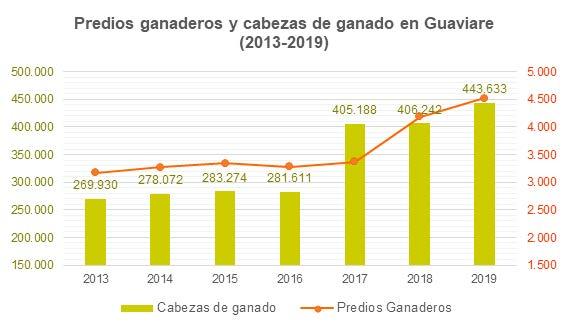
Cattle farms and cattle (2013 - 2019). ICA.
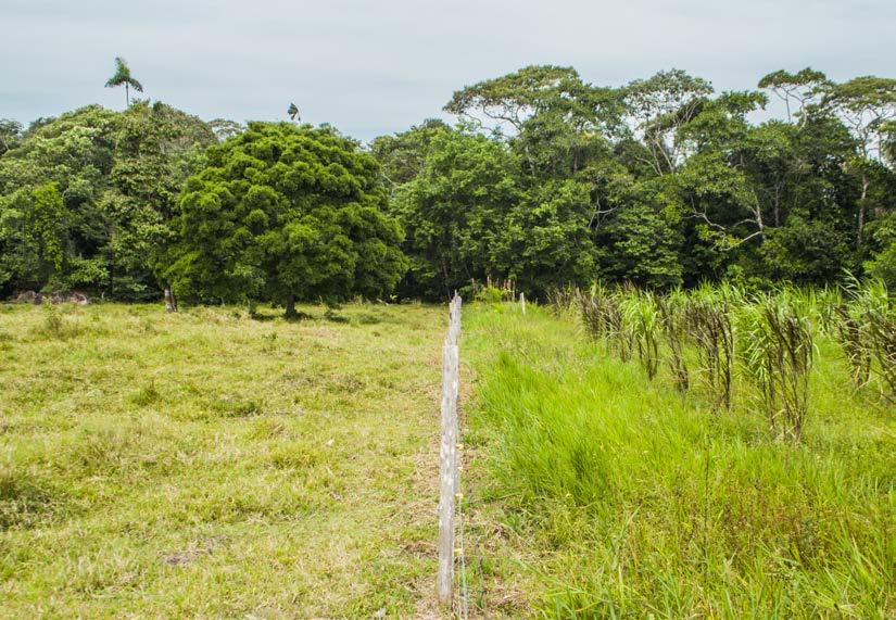
their pastures by at least one hectare per year, taking land away from the forest. Similarly, given that many members of FARC-EP left Guaviare, land grabbing by landowners with a large purchasing power increased, which allowed them to buy farms from small farmers, who still maintained part of their property with Amazonian Forest.
The creation of large pastures from areas of forest that have been deforested (forest conversion) is also related to some of the inhabitants of Guaviare, since, according to several of those interviewed, the activity of clearing the forest and cutting down trees is part of the work that generates income for several families in that region.
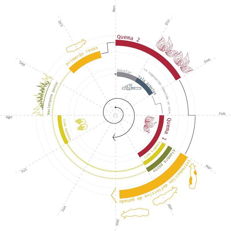
According to farmers, the process of forest conversion lasts one year and is linked to certain characteristics of the environment. It
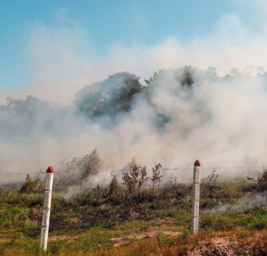
begins between November and December, removing plants and weeds from the forest or from the stubble. After that, trees are cut down using a chainsaw. From the moment this method began to be used, the felling capacity per person has drastically increased. According to farmers, felling one hectare of forest takes one person one day. In the month of February and until the beginning of March, when the cut plants are dry, they start burning what has been cut down.
This is done during this period because temperatures are at their highest and rainfall is the lowest of the year. Once the controlled burns have been carried out, corn and grass are planted in March. Corn is harvested between July and August and grass is left intact.
According to testimonies, the grass flourishes in August, but it is not until September or October that the first cattle are put in. Since the first newly born grass is not useful, the objective of these first cattle is to compact
Fires in grasslands in San José del Guaviare, Guaviare.
Process of praderisation of the forests of Guaviare.
the soil by stomping. In November and December grass is burned again so that it flourishes once more with the compacted soil, so that the cattle can be introduced again and an area that only a year ago was occupied by forest is then considered “converted”.
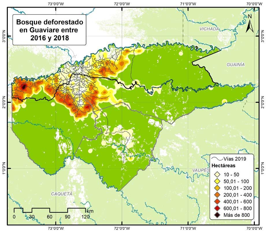
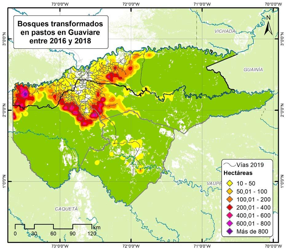
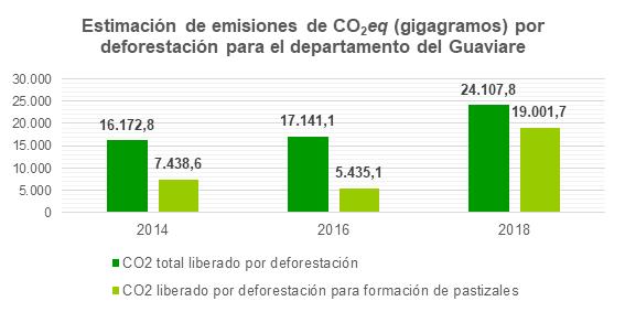
Density maps were made from the information on land cover in the Colombian Amazon developed by the Amazon Scientific Research Institute (SINCHI by its Spanish initials), which identifies land cover between 2012 and 2018 in two-year periods. This information also shows the areas where changes in land cover occurred, such as the decrease and increase of forests and pastures.
Between 2016-2018 forests in the region of Guaviare went from 4,544,466 hectares to 4,495,519 hectares, the loss of forest was 52,689 hectares with an increase of 3,742 hectares. This phenomenon was concentrated in the kilometers close to the agricultural frontier with a greater action on the western
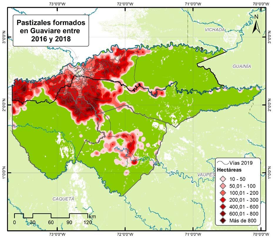
flank in the western villages of San José del Guaviare and the northeastern villages of the municipality of Calamar. On regards to the formation of new pastures in the region, they went from occupying 425,544 hectares in 2016 to occupying 508,329 hectares in
Extensive livestock farms, San José del Guaviare
Deforestation in Guaviare department between 2016 and 2018, made with SINCHI data.
2018 increasing by 19.5%. During that period there was a formation of 110,470 hectares of new pastures with a loss of 27,685 hectares giving a net increase of pastures of 82,785 hectares in those years.
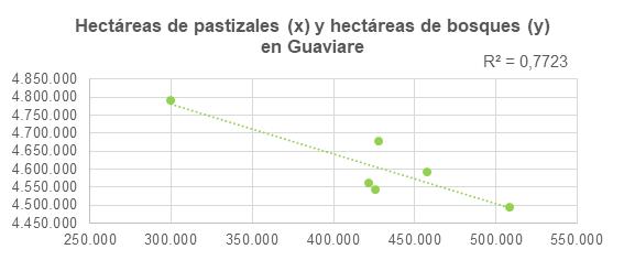
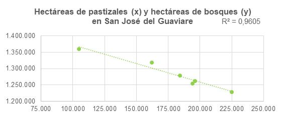
To verify this relationship between the increase in pasture cover and the decrease in forest cover, a scatter plot with a simple regression between the number of hectares of each cover was chosen.
In the municipality of San José del Guaviare there is a very high correlation equal to 96% between the increase of grasslands represented on the X axis, and the decrease
of forest represented on the Y axis, from 2002 to 2018. This developed from the information obtained from the coverages generated by the SINCHI Institute.
In the case of Guaviare for the same period, the correlation between the increase of pastures and the decrease of forest, represented in the same axes, is lower with a value of 77%, but there is still a relationship.
The above is not directly related to the cattle raising activity, although it is known that the pastures present in the Guaviare region are generally used for cattle raising, there is not enough information to confirm
Hectares of grassland (X) and hectares of forest (Y) in Guaviare.
Hectares of grassland (X) and hectares of forest (Y) in San José del Guaviare.
Grasslands created in the Guaviare department between 2016 and 2018. Forests converted to grasslands in the Guaviare department between 2016 and 2018.
how many hectares of pastures are used for that activity, so the grasslands identified by the SINCHI Institute are assumed to be used for cattle raising.
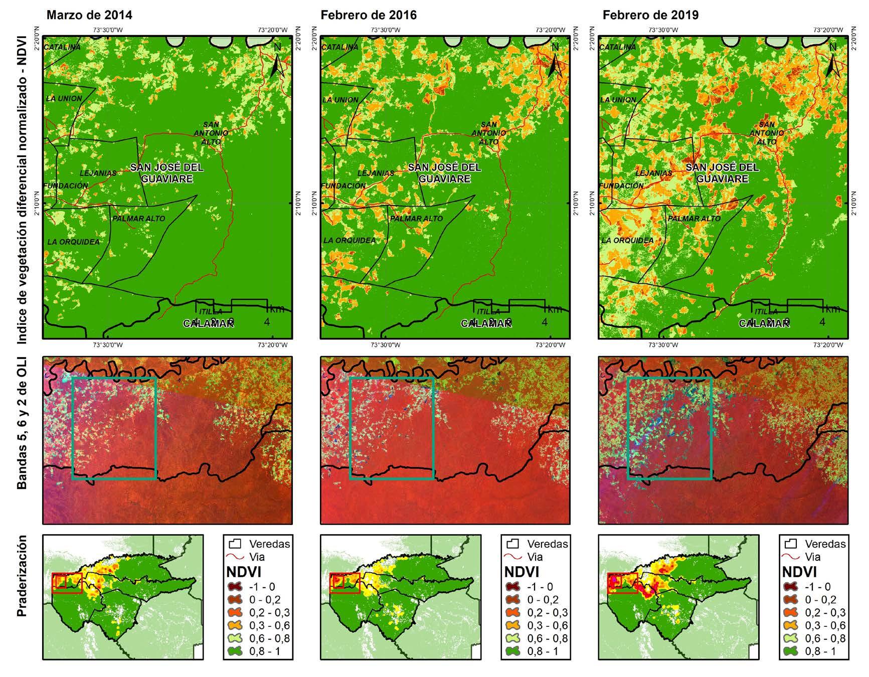
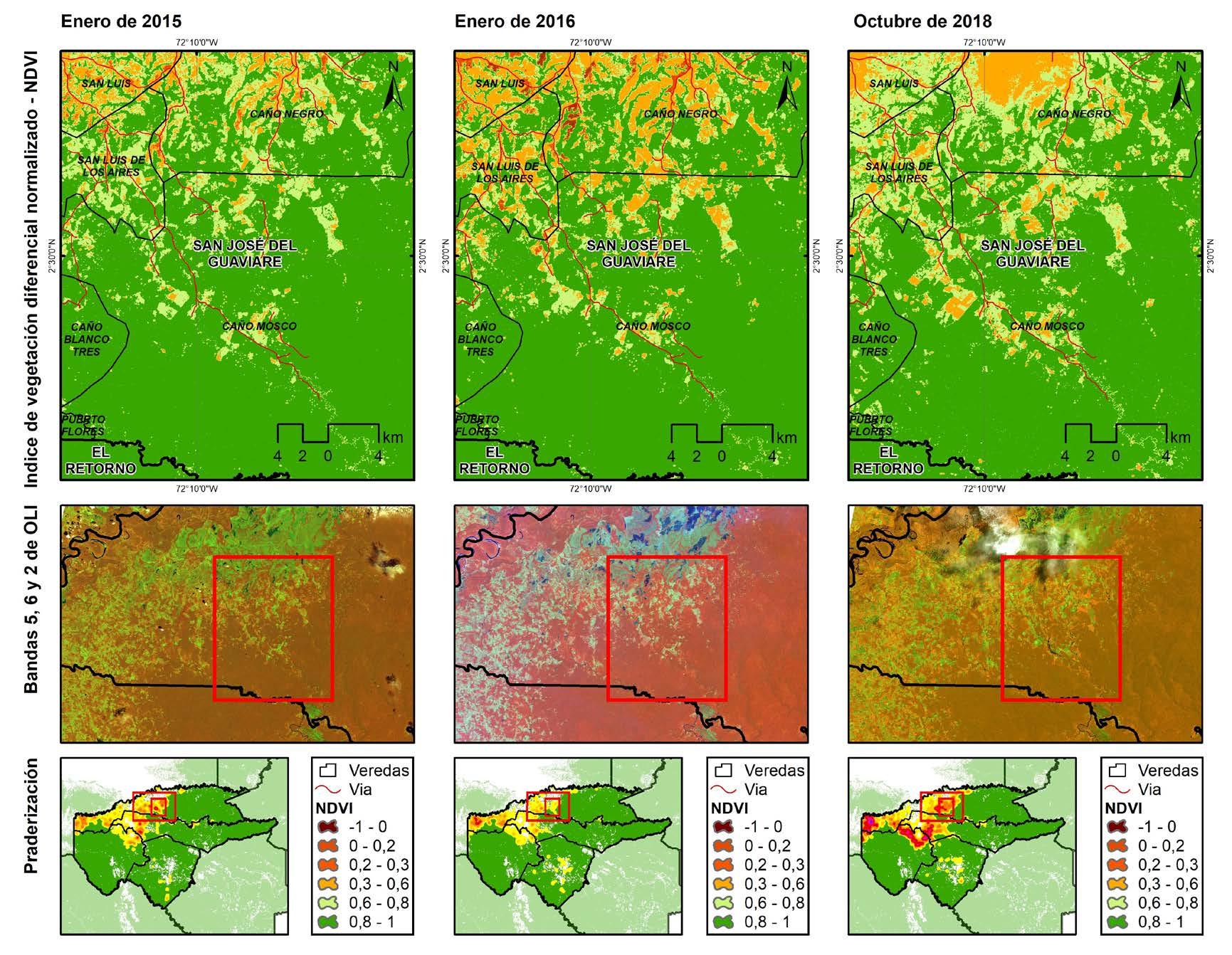
The Normalized Difference Vegetation Indexes (NDVI) made from LandSat 8 satellite images show the advance of deforestation in two fronts where there is the greatest transformation of forest into pastureland, both areas are located in the municipality of San José del Guaviare close to the agricultural frontier.
The western front, with the largest grassland area, is driven by several road axes including the Marginal de la Selva highway that sought to connect Meta with Caquetá departments, and on a large scale Venezuela with Ecuador. This project began in the 1960s but after decades of inactivity was resumed in 2012.
In Guaviare this road drove deforestation and informal economies uncontrollably, which led to the questioning of the project and its subsequent cancellation in 2018. It is not possible to assure that all of the pastures formed, or forests transformed into
Main deforested areas in the Guaviare department.
pastures are the result of deforestation for cattle ranching, however, once again we have opted for a simple linear regression to correlate the loss of Amazonian forest with the increase in the cattle herd in Guaviare. The impact of deforestation, whether to introduce pasture or another activity other than cattle ranching, goes beyond an
Main deforested areas in the Guaviare department.
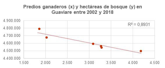
Cattle ranches (X) and hectares of forest (Y) in Guaviare between 2002 and 2018.
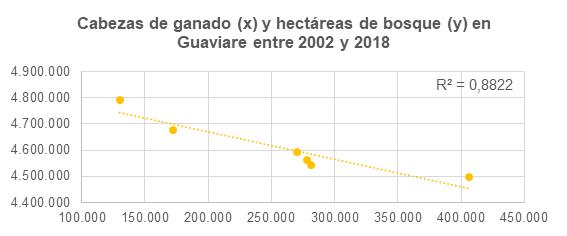
Cattle (X) and hectares of forest (Y) in Guaviare between 2002 and 2018.
ecosystemic impact; cattle ranching and deforestation are among the main causes of methane (CH4) and carbon dioxide (CO2) emissions, respectively.
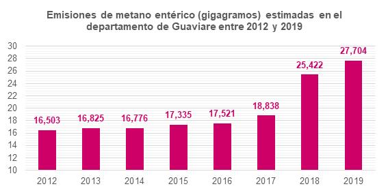
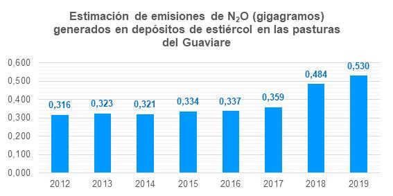
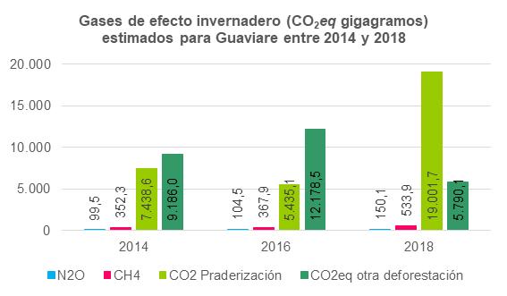
Using the Intergovernmental Panel on Climate Change (IPCC) Tier 1 methods for greenhouse gas (GHG) emission estimates, enteric methane and nitrous oxide emissions were estimated. For this purpose, the amount of cattle was obtained from the Colombian Agricultural Institute (ICA by its Spanish initias), as well as the standard figures developed by the Food and Agriculture Organization of the United Nations (FAO) for Latin America in values such as CH4 emission factor, N2O emission factor, excretion rate,
among others. Both enteric methane and nitrous oxide emissions present a drastic increase after 2016. Emissions of enteric methane and nitrous oxide are closely related to cattle activity, since their origin, being the organism of the cattle itself, catalogs them
as the gases most closely related to cattle, mostly enteric methane.
On the other hand, according to the Institute of Hydrology, Meteorology and Environmental Studies (IDEAM by its Spanish initials), tropical rainforests in Colombia have the capacity to store 132.1 tons of carbon per hectare, carbon that is released into the atmosphere when the forest is cut down, and further increasing emissions when the biomass is burned. Just as enteric methane and nitrous oxide emissions respond directly to cattle numbers, carbon dioxide emissions figures respond to deforestation figures.
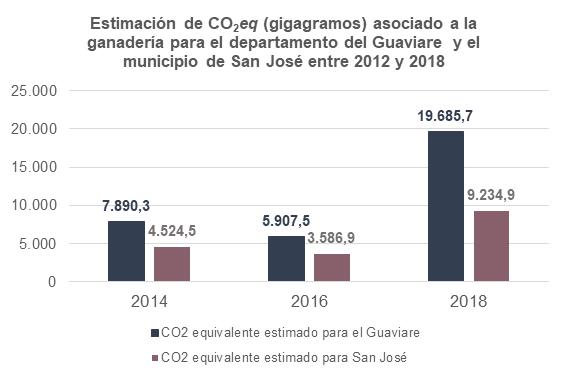
The conversion to carbon dioxide equivalent for a period of 100 years for CH4, N2O and C allows estimating the total emission of greenhouse gases related to cattle. For
this estimate the values of carbon dioxide equivalent for enteric methane, nitrous oxide and carbon dioxide from transformation to pasture were added up. This last gas was equivalent to 95.3% of the region’s total emissions and 94.3% of the municipality’s total emissions, while enteric methane and nitrous oxide represent about 3.7% and 1% of San José’s total emissions respectively, and about 4.5% and 1.3%, respectively, of the region’s total emissions.
Estimated enteric methane emissions (Gigagrams) in the Guaviare department between 2012 and 2019.
Estimated emissions of CO2 eq (Gigagrams) generated by deforestation for the Guaviare department.
Estimation of N2O eq emissions (Gigagrams) generated by manure deposits in pastures in the Guaviare department.
It is evident how in the period after the signing of the peace agreement, both the increase in cattle and the arrival of deforestation agents, influenced not only the conversion from forests to pastures for a presumed cattle objective, but these dynamics in the number of heads of cattle and land conversion
have repercussions on the global climate dynamics. The emissions that may reach the atmosphere will contribute to global warming bringing socio-environmental consequences that have already been widely publicized.
To counteract this, several plans, projects, and proposals have been put forward in Colombia from different positions in order to reduce greenhouse gas emissions caused in different sectors of the economy.
Silvopastoral systems represent one of the best options for climate change mitigation and ecosystem restoration in areas where there has been forest conversion. It consists of the incorporation of individual trees to generate some agricultural or wood products by interaction with pastures for cattle. These trees can be introduced as live fences that divide the paddocks as well as separate cattle from roads and nearby water sources.
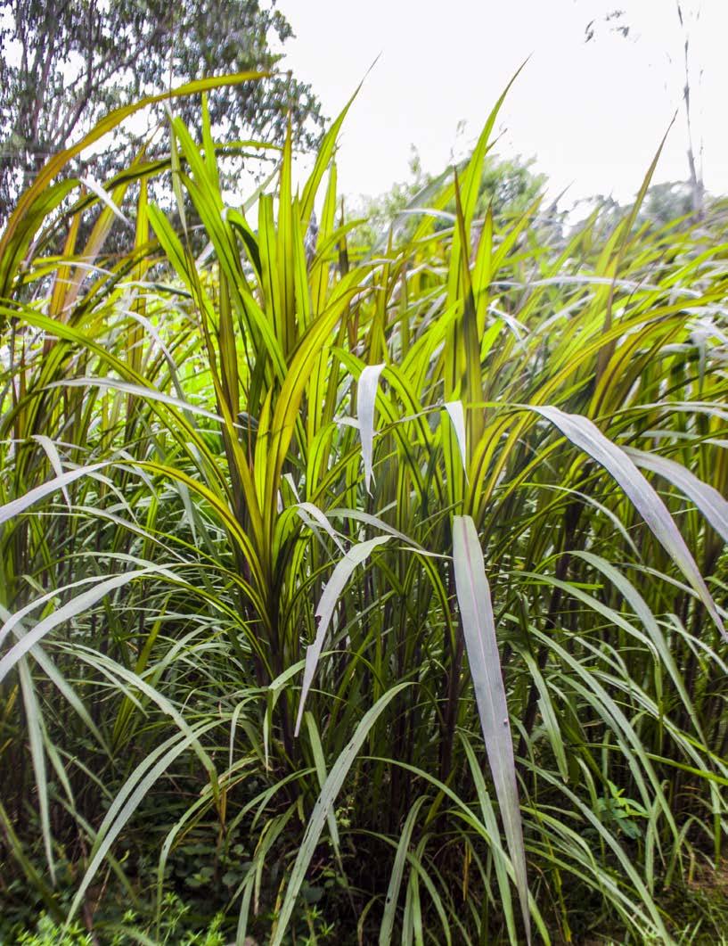
In addition, new ways of raising cattle are beginning to emerge. The increasingly constant use of corrals has meant that the areas destined for shepherding are smaller, thus reducing forest clearing, which is improved with a diet using fast-growing grasses, further reducing the area of clearing and increasing dairy production. In this way,
Fast-growing Grass used in cattle systems in Guaviare.
Estimated CO2 eq (gigagrams) associated with cattle ranching for the department of Guaviare and the municipality of San José between 2012 and 2018.
Estimated greenhouse gases (CO2eq gigagrams) for Guaviare department between 2014 and 2018.
farmers see benefits such as economic gains and reduced deforestation.
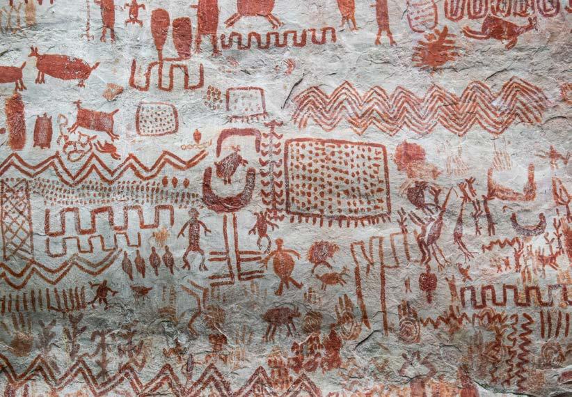
Finally, the activation of other sectors of the economy, such as ecotourism, has been proposed in the Guaviare department because it has areas of high cultural and ecological value that were inaccessible years ago due to the conflict. Nowadays, Guaviare has been rediscovered and tourism has been proposed as an activity that shows a new face of the region and that rural inhabitants have chosen to have an extra income. Tourist attractions such as the 12 thousand year old pictographs found in
the Serranía de la Lindosa and the Serranía de Chiribiquete have earned the latter a UNESCO World Heritage Site designation. Similarly, scenic attractions such as Ciudad de Piedra, Trankilandia or the Guaviare River itself, are promoted by the tourism agencies and offices located in San José.
Division of pastures in cattle ranches in Guaviare department.
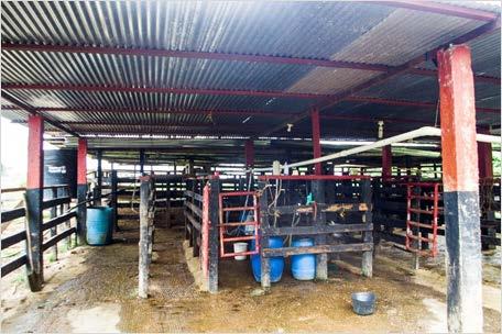
Milking system on cattle farm in Guaviare.
Pictographs of Cerro Azul in the Serranía de la Lindosa, San José del Guaviare
Aquatic plant Macarenia clavigera (Rhyncholacis clavigera) endemic to Serrania de la Macarena (Meta department), and Serrania de la Lindosa (Guaviare department).
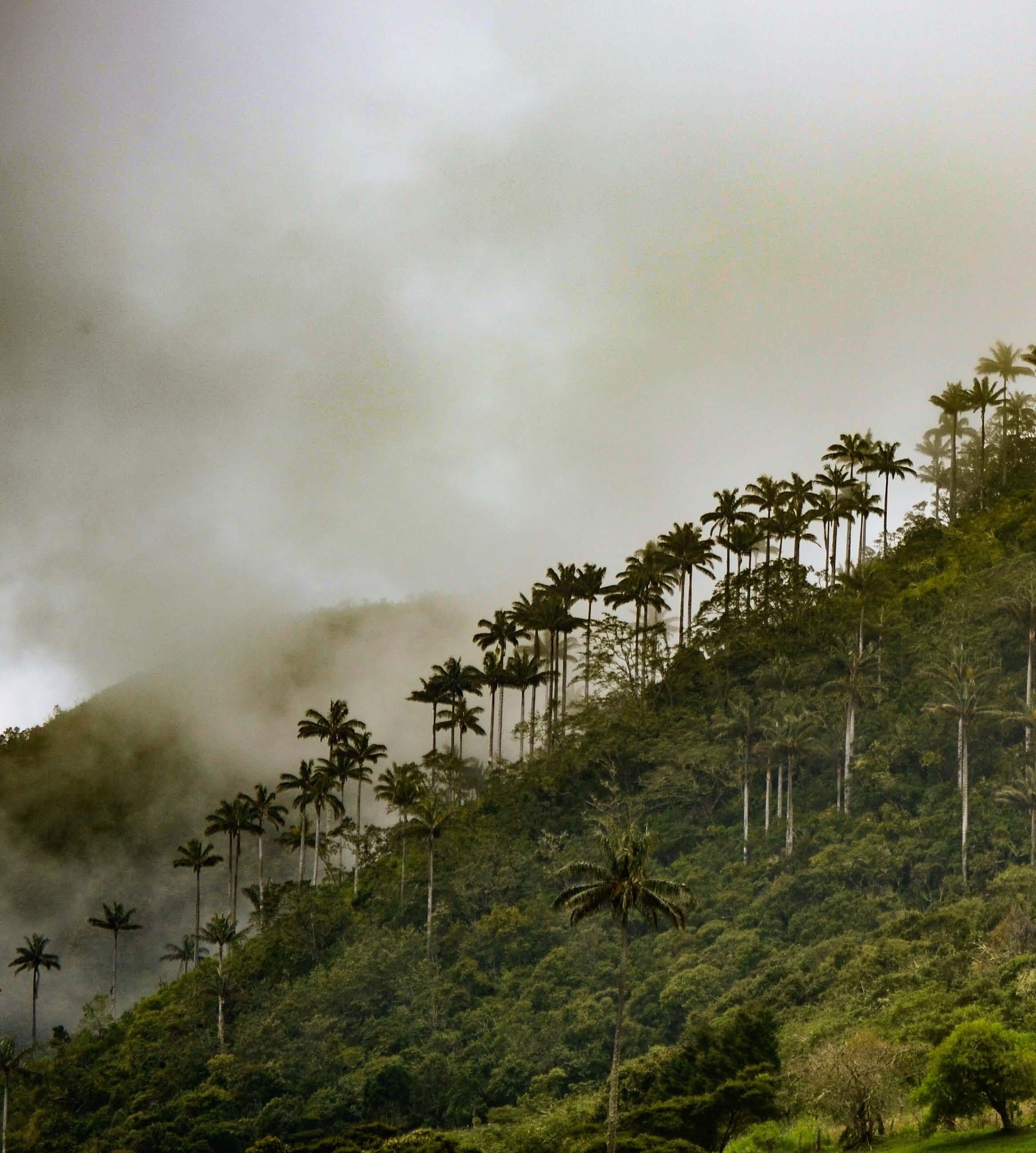
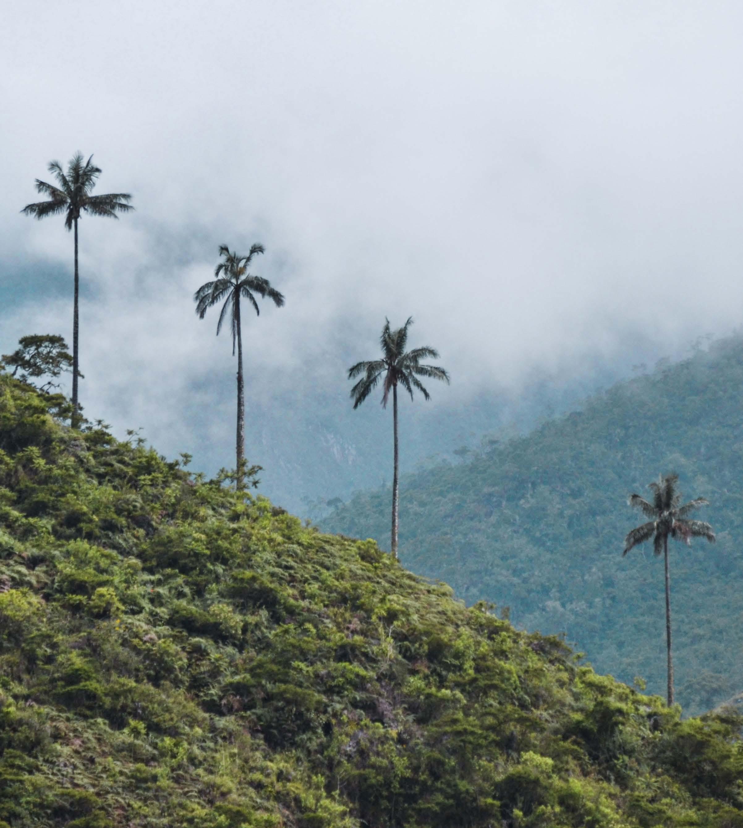
Wax palms in Toribio, Cauca, Colombia
taken by César Bautista, 2017