ALEXANDRA CANAL PRECINCT
BAEN3002 500587595
CONTENTS COVER CONTENTS SITE CONTEXT STRATEGIC CONTEXT SITE ANALYSIS LANDMARKS GREEN COVER SWOT VISION STRUCTURE PLAN STRUCTURE PLAN KEY STEPS PRECEDENT STUDIES p. 1 p. 2-3 p. 4-7 pp. 8-11 p. 12-13 pp. 14-15 pp. 16-17 p. 18-23 p. 24-27 pp. 28 pp. 29 p. 30-35
MASTERPLAN CONCEPT MASTER PLAN DESIGN ILLUSTRATIVE MASTER PLAN KEY SPACES CONNECTING WITH COUNTRY DESIGN GUIDELINES: GENERAL pp. 36-39 pp. 40-41 pp. 42-73 pp. 75-87 PP. 88-89
PROJECT CONTEXT
OVERVIEW
The Alexandra Canal Site is located in the southern section of the City of Sydney. Greater Sydney is currently in the process of planning for the growing population and changing needs of the population. Infrastrucutre, liveability and sustainailbity are the focus of the new ‘Metropolis of Three Cities’ planned for the Greater Sydey Area.
The south eastern portion of the Harbour CBD will continue to be an important hub of strategicly located enterpise and economic area due to its proximity to Sydney Aiport and to Botany Bay. Key high value sectors in this district includ transport and logistics and manufacturing to professional and creative services.
Nonetheless, this area also contains key residential areas and services for those residents. Gentrification continues to be a serious problem for both residents and industry. Any proposed solution must take these potential issues into account.
CANADA BAY
INNER WEST
SYDNEY
RANDWICK
WAVERLY WOOLAHRA
BAYSIDE
EXISTING SITE
LGA: CITY OF SYDNEY
SUBURB
:
ALEXANDRIA
SUBURB POPULATION:10,962
DISTRICT: GREEN SQUARE
The site is located between Sydney Park and Bourke Rd. The Alexandra Canal cuts through the site from North to South. Alexandra Canal is situated within the suburb of Alexandria, 5 km from Sydney City. The area contains various diverse uses, including historic industry and enterprise. The area is close to some residential including both gentrified terrace housing close to Newtown and social housing in Waterloo. There is need for strategic development and revitalisation of the area.
SYDNEY PARK RD
MADDOXST
MADDOXST
ALEXANDRA CANAL BURROWSRD EUSTONRD
HUNTLEYST
BOURKERD
HUNTLEYST COLLINSST
BOURKERD
MITCHELLRD EUSTONRD O’RIORDANST
DOODYST
SYDNEY PARK


CONTEXT 6 and B7 Business Park. They are mostly in the southern enterprise area, previously referred to as
RE1 IN1 B6 B7 R1 B2 B4 public recreation general industrial enterprise corridor business park general residential local centre mixed use LAND ZONING FROM LEP 2012 HISTORICAL MIX OF INDUSTRIAL AND RESIDENTIAL SOUTHERN ENTERPRISE AREA PLANNING PROPOSAL TO SYDNEY DCP (2022)
STRATEGIC
the southern employment lands, in the suburbs of Alexandria and Rosebery. Figure 1 Enterprise Areas
Traffic and Transport Assessment
STRATEGIC CONTEXT
The Site is located within the City of Sydney in NSW. The specific strategic planning context that applies to this site help guide the masterplan. The site around the North end of Alexandria Canal is located within the Southern Enterprise Area of the City of Sydney District. It is on the corridor connecting Botany Bay and Sydney Airport with both the CBD and the North.
(p. 60, LSPS 2020) This site’s industrial use is protected but so is its potential for connecting people with housing, amenity, and employment opportunities within the same thriving area.
2.4.1. Walking Network
The large population catchment around North Alexandria is supported by the City’s investment in walking in the local area. The Liveable Green Network (see Figure 4) supports walking to residential areas and provides a connection to public transport in the area. This provides improvements to lighting, planting, pavement materials, kerb extensions, continuous crossing treatments and landscape amenity

Figure 4. Liveable Green Network near North Alexandria
LIVEABLE GREEN NETWORK
PEDESESTRIAN AND CYCLE CONNECTIONS TO CITY
In a more regional context, the site is situated within the proposed Southern Enterprise Area, which was a planning proposal to change the Sydney DCP in 2022. This suggests amending planning laws to better accomodate underutilised enteprise type floorspace in Alexandria and Rosebery. It also allows for public housing development alongside continued protection and encouragement of Industrial and Enterprise areas.
As stated in the City Plan 2036 LSPS, the area is “one of the largest consolidated areas of urban service and industrial lands in the District, which makes it essential to the District’s ongoing productivity.”
The Western portion of the site is zoned IN1 general industrial while the easter part of the site is zoned B6 enteprise corridor. The majority of this zoning will be retained in the masterplan. However several smaller areas within the site will be rezoned to allow for multi use developments. This will contribute towards the potential of the site for assisting people with housing and services within the area.
Finally, while the Liveable Green Network is an important part of the City of Sydney’s efforts to provide connections for pedestrians and cyclists, this site lacks good sustainable connections, particularly the bike route along Huntley St.
9
DOCUMENTS
City Plan 2036: Local strategic planning statement
Sustainable Sydney 2030–2050 Continuing the Vision • 10 project ideas • 10 directions for 2030 - 2050 • 1. 2. 3. 4. 5. 6.
• 20 year land use vision
6 value based principles • guide for decisions made by City of Sydney STRATEGIC CONTEXT
CSPdesignedto imp l 05-032SStneme KEY
• 13 priorities and a series of actions to achieve the vision and guide future visions to our planning controls Community Strategic Plan 6 KEY VALUES extrapolated from strategic planning documents SUSTAINABILITY AND NATURE MEANINGFUL SPACES ATTRACTIVE VILLAGE CENTRE THAT ENC0URAGES CLOSE DISTANCE BETWEEN WORK AND HOUSING PRESERVATION AND ENHANCEMENT OF BUISNESS/INDUSTRY HUBS RESILIANCE INFRASTRUCTURE AND TRANSPORT
STRATEGIC MERIT
This Alexandra Canal area rejuvenation will provide strategic merit to the area. Each of the six value based principles found in the Community Strategic Plan is designed to implement the Sustainable Sydney 2030-2050: Continuing the Vision documnet. Each of these principles is demonstrated in this masterplan.
Overall sustainability and nature will be increased through the naturalisation of the Canal and the inclusion of greenery in all new public spaces. Those new public spaces and walkways will provide meaningful spaces for both workers and residents. These public spaces will assist in the preservation and enchancement of the important enterprise and industry hubs. This will again also augment the resiliance of the area. Finally, pedestrian centric infrastructure and transport will be improved through the revitlisation of the pedestrian connections and walkways.
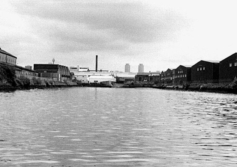
 Image: Old Wool Store across the Alexandra Canal 1993
SITE ANALYSIS
Roads and Streets
The Alexandria site is located between two major roads: Bourke St and Euston St. Huntley St connects these two major streets and there are no other easily accessible ways to connect these two areas. This makes it difficult for those in the South-East area of Alexandria to connect to Sydney Park.
Transport
There are several bus stops within the area, ecspecially along Bourke St. The bus stop on Bourke St is not a busy route. St Peters Station is across Sydney Park and is approximately 17 mins walk. Green Square Station is also approximately 17 mins and functions as a centre of the area. However, the connections between these areas are a busyroad that is not easily walkable. The area is mostly accessed by cars and the public transport is not highly utilised. Walkability is not strong in the area. Sydney Park is very walkable and a key point of
interest in the area.
Heritage
There are several key heritage items within the site. The corner of Huntley St and Bourke St contains over 1 square kilometre of space dedicated to heritage sites. These sites range from 19th century factory buildings to 1970 architect designed storage buildings.
proximately a block to the South-East.
Green Spaces
The two main green spaces within the area are Sydney Park and Perry Park. Perry Park has a grass sports field and an adjoining recreation centre.
Libraries
Cycle Lanes
The cycle lanes within the site are not a well connected system. There are dedicated bike lanes along Bourke St and along the top of the Canal. However, these are not connected so cycling between Bourke St and Euston St is dangerous.
Zoning
The zoning within the space is mostly enterprise and industrial zoning. Residential areas are located just outside the site to the North-West and a ap-
The closest library is Green Square. Newtown library is slightly further away. The area is dedicated to industrial and enterprise uses and not community uses such as libraries.
Retail
The site contains a handful of retail spaces, including some discount outlets and brand flagships.
Active Frontage
There are key active frontages containing retail and enterpise facilities along Huntley St and Bourke St .
KEY
B T bus stop train station heritage
RE1 general recreation train line key road dedicated cycle lane water
R1 general residential
B4 mixed use
IN1 general industrial B2 local centre
B6 enterprise corridor
SYDNEY PARK
BOTANY BAY AND SYDNEY AIRPORT

N T T T T T T T
TOWARDS
TOWARDS
1 B B B B B B B B B B B B B B
TOWARDS
CITY OF SYDNEY CBD
INNER WEST
LANDMARKS
The key existing landmarks within Alexandria contribute to the unique character of the area. These patricular sites stood out within the area. Some of these sites are underutilised despite their significance. Industrial, enterprise, historical and residential landmarks within this site are considered during this design process.
Heritage
The Grounds of Alexandria within the refurbished historic site known as The Mill is well loved and used. However the remainder of the site which houses an ecclectic mix of industries is under landscaped. The site feels cold and unpleasant.


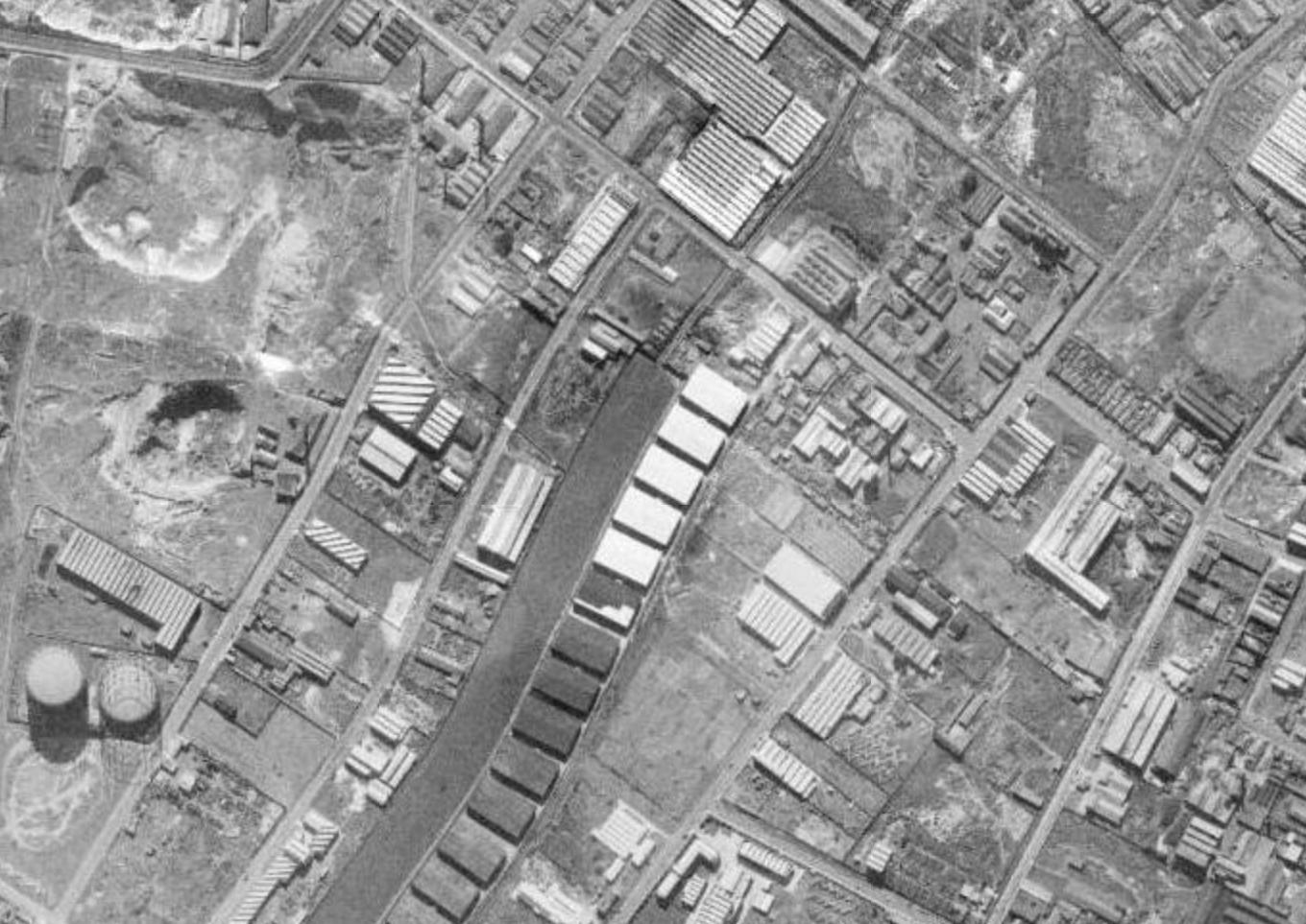
The Woolstores are historical structres constructed during WWII to hold production overflow. The three remaining were renovated and currently hold a mix of enterprise buisnesses. Adjacent to these is the 18,000 sq metre Harry Siedler Q-Store purpose-built as a store for the New South Wales government in 197.

cording to the State Heritage Inventory, this small scale late Federation Free style sewage pumping station’s porominatnt corner location has streetscape significance. However, large amount of realestate is wasted on the neglected landscaping and surrouning fencing.
Green Space
On the western side of the site, Sydney Park is a well designed and well used large greenspace. This space is described on the City of Sydney website as a “multi-award-winning regional park with extensive off-leash areas, rolling hills, large playground, children’s cycle track, skate park, wetlands, sports oval and outdoor fitness areas.” However this is not well integrated into the streets of the site.

Residential
The Water Board Pump House sits on the corner of Huntley St and Burrows Rd. Ac-
Acracdia Apartments sit on the Sydney Park Rd, Euston St and Huntley St. It is a large strucutre made of recycled bricks with significant streetscape significance and appeal. However, it is not serviced by the busy and unsafe adjacent intersection.
 Sydney ParkAlexandra Canal
Harry Siedler Q-StoreGrounds of Alexandria
Sydney ParkAlexandra Canal
Harry Siedler Q-StoreGrounds of Alexandria
1 2 4 5 7 8
Alexandra CanalWB Pump House


Arcadia Apartments Woolstores Heritage Stoneworks 6 3 9 3 4 5 1 6 2 7
SYDNEY PARK HUNTLEYST MADDOXST MADDOXST HUNTLEYST COLLINSST DOODYST BOURKERD BOURKERD MITCHELLRD EUSTONRD O’RIORDANST ALEXANDRA CANAL BURROWSRD EUSTONRD SYDNEY PARK RD
Green Cover
The City of Sydney Data websites list the street trees within the City Of Sydney. Street Trees add to the general green cover. They filter both air and stormwater and help lower city temperatures through reducing the heat island effect. Importantly, they also create beautiful streets and relieve stress.
Key Findings:
- Euston Rd before and after the Huntley St and Sydney Park Rd intersection lacks Green Cover.
- There is a lack of Green cover within the industrial sites and the Business Park.
- Sydney Park and the Residential Area beyond Sydney Park Rd and Euston Rd has a higher than average amount of trees
- Original trees will be protected and incoporated into future revitalisation and greening of the area.

Location of Existing Trees
 Image: View of Street Trees looking West along Huntley St
Image: Volunteers assisting with tree planting in Sydney Park, 1992
Image: View of Street Trees looking West along Huntley St
Image: Volunteers assisting with tree planting in Sydney Park, 1992
SWOT
STRENGTHS
The Alexandria site is located within close proximity to the popular Sydney Park which contains a revitalised waterscape and lake in the centre of the park. In the north eastern corner of the site are a collection of strong and characterful heritgae spaces. These are already redeveloped and include the popular Gardesn of Alexandria and The Woolsheds. Huntley St contains retail spaces with active frontages. There is also a strong cafe culture throughout the site and the surrounds. There is also a strong industrial and enterprise use in the area.
site boundary enterprise and industrial uses
heritage space
active frontage green space
cafe
17 MINS TO ST PETERS 25 MINS TO MASCOT
WEAKNESSES
One key weakness of the site is the unpleasant smells gathered around the tributaries of the Alexandra Canal that run through industrial areas and into Sydney Park. Underuntilised tributaires of the canal are partially under concrete and are uncared for between the canal and Euston Road. The lack of dedicated landcaping around the canal does not make it an advantage place. Paired with this, there is a lack of public spaces for workers. The enterprise buisness park area of Huntley Rd is underutilised due to current working-from-home practices and habits.
17 MINS TO GREEN SQUARE smells estimated walking time
17 MINS TO GREEN SQUARE
site boundary direction of train station
underutilised canal tributary
OPPORTUNITIES
A key opportunity is the existing but underutilised connection to new and existing residential areas. These areas are already full of character and heavily desirable areas. Within the sites are important heritage elements that either adjoin or are situated on unused sites. Views and spaces are provided by the blue infrastructure of the heritage Alexandra Canal.
site boundary vacant space
residential areas
blue infrastructure
key views
EUSTON ROAD
THREATS
There are several threats to the site. Due to a pending redevelopment and upgrade to the bike paths and pedestrian spaces on Sydney Park Rd. This will increase the frieght traffic from Campbell St to Euston Road. The current focus on car-centric spaces and inaccessability of public transport leads to over parked streets inacessability by pedestrians. The interesction of Euston Road, Huntley St and Sydney Park Road is a busy and unfriendly pedestiran conenction. There is also a risk that redevelopment will push industry and enterprise form the area.
site boundary over parking
dangerous pedestiran crossing
active frontage heavy traffic
underused space
VISION
VISION
A multifaceted vision has been developed for the future of south Alexandria, a unique precinct clustered around the northern end of the Alexandra canal . The encouragement of diverse enterprise uses such as entertainment in the local area, including stimulating the nighttime economy, to augment the cafe culture already existing within the Grounds of Alexandria
Connecting with Country through the Naturalisation of the concrete sides of the canal coupled with the planting of native water species for the cleaning and restoration of the waterway
Integration of public spaces wrapped around the preexisting heritage buildings
Increase of pedestrian appeal and safety to draw people out of the streets and into the new spaces
OBJECTIVES
The vision of this project will be achieved through the implementation of Twelve Urban Quality Criteria Objectives developed by Jan Gehl. These are found in the Literature of the Gehl Institute and are structured around three main themes: Protection, Comfort and Enjoyment.
PROTECTION protection against traffic and accidents. protection against harm by others.
options for mobility. options to stand and linger.
protection against unpleasant sensory experience. options for sitting.
COMFORT
options for talking and listening/hearing. options for play exercise and activities. options for seeing.
ENJOYMENT
scale.
opportunities to enjoy the positive aspects of climate
experience of aesthetic qualaties and positive sensory experiences.
VISION
The space rejuventation takes inspi ration from various local and inter nation projects. These spaces have proven to be welcoming and lively while also paying strong attention to nature and the environment.


These spaces give examples for how urban design can create focus points for gathering and community engagement.

STRUCTURE PLAN
site boundary green pedestrian walkways bridge new public space
reconfigured industrial zones
reconfigured enterprise zones
STRUCTURE PLAN
KEY STEPS
There are 5 key steps of the restructuring of the Alexandria Precinct. Through these, the vision for the precinct will be achieved. Each element of the design addresses through the strategic context. The space’s useability and attractiveness of the general area will be improved thorugh the revitalisation of this site.
1 The amount of meaningful public spaces will be increased through the creation of 3 squares. One square will be dedicated to a mixed-use development.
2 Both enterprise and industrial spaces will be reorganised to incorporate the improvment of pedestrian experience and connection to canal and new public spaces.
3 Pedestrian walkways will wrap around the existing historical buildings and the reconfigured enterprise areas. These will include substantial plantings to increase green cover.
4 Additional bridges across the canal will improve connections, view captures, and more useable public spaces. These will work hand in hand with the new public spaces.
5 The canal revitalisation will improve the blue amenity of the valuable space. Walkways on the sides of the canal will increase useablity and attractiveness.
STUDIES PRECEDENT
PRECEDENT STUDIES
The use of strong, relevent precedents was an important part of the master. Both international and local projects have encountered similar sites, situations, and problems.
The precedents collected include the Lowell Canal Revitalisation Masterplan from Massachusetts, Precinct 75 in St Peters Sydney, and Alexandra Linear Park in Singapore. Each of these projects incorporate green and natural design.

They each strive to enhance the character of their area.
Key aspects of each site were analysed. The design process were guided by this analysis. While some aspects of each precedent fall short of what could be achieved here in Alexandria, they provide insights and provide the framework for a critical deisgn process.
PRECEDENT STUDY
PROJECT: Lowell Canal Revitalisation Masterplan


LOCATION: Lowell, Massachusetts
DESIGNERS: Gina Cannistra, Ha Min Joo, Yazma Rajbhandary. DATE: 2015
LGA: Lowell City Council
SUCCESSES:
SIMILARITIES:
1: The new crossings over the revitalised canal provide useful pedestrian and cycle connections, while the placemaking strategies at along the banks of the canal work to bring people closer to the water’s surface. 2, 3: The revitalisation project is part of a larger project to revive the centre of Lowell.
DIFFERENCES:
• incorporation of public spaces within enterprise area • mix of enterprise and commercial retail and food • respect of heritage area • pedestrian friendly spaces • in use industrial buildings • weaving design around heritage structures • similar sized site • larger scale project
ALIGNMENT WITH VISION
• the canal is made clean, safe, and attractive with extensive landscaping that brings people closer to the water.
• public and pedestrian spaces are wrapped around the heritage buildings to honour and accentuate their history and value • the pedestrian experience is enchanced through dedicated pedestrian only bridges, walkways, and public spaces
1 2 3
PRECEDENT STUDY
PROJECT: Precinct 75
LOCATION: Mary St, St Peters Sydney
DESIGNERS: Cox Architecture DATE: 2017
LGA: Inner West Council
1: This development provides public amentiy through provision of public green spaces. These include walkways, market square, and a pocket park.

SUCCESSES:
• incorporation of public spaces within enterprise area
• mix of enterprise and commercial retail and food
• respect of heritage area
• pedestrian friendly spaces
SIMILARITIES:
• in use industrial buildings
• weaving design around heritage structures
• similar sized site
DIFFERENCES:
• no canal
• less public space
• addition of residential apartment buildings
BCA, Structural Assessment and Fire Safety
An assessment of the proposed design has been undertaken against the Deemed Satisfy provisions of the relevant sections of the BCA to identify compliance It also assessed the impact of the upgrade works that are proposed The assessment revealed that through the Deemed

2, 3: Inclusion of retail, enterpise, and residential encourages activity and atmosphere in the area during both the day and the night.
ALIGNMENT WITH VISION
The BCA report is supplemented by a Fire Safety Audit that confirms that a fire engineered Alternative Solution is possible to meet the relevant Performance Requirements of the BCA.
• public and semi private greenspaces will improve green cover

An investigation of the structural integrity of the existing buildings and the impact of the proposed demolitions, adaptive reuse and new construction associated with the intended design scheme has been undertaken by SDS Consulting Engineers. The report concludes that the structural integrity of the existing buildings will not be compromised or undermined by the construction of the new buildings and basement car park. Furthermore, the existing buildings are structurally suitable for the incorporation of the proposed works and additions.
• the new buildings and public spaces are placed around the existing heritage precinct 75 warehouses.
6.6 Services
• pedestrian only walkways, squares draw people off Mary road and provide attractive, walkable amentiy for new and existing users.
An investigation of the existing site services has been undertaken by IGS Engineering Services. Consultations have been carried out with Railcorp, RMS, Ausgrid, Sydney Water, Jemena, Telstra/Optus/Uecomm and Marrickville Council. Based on information received sufficient supply is available for sewer,
Figure 51 Landscape Concept
1 2 3
PRECEDENT STUDY
PROJECT: Alexandra Canal Linear Park


LOCATION: Singapore
DESIGNERS: Public Utilities Board
DATE: 2011
LGA: City Council of Singapore
SUCCESSES:
• water quality improvment

• mitigates flooding through working with the natural environment and climate of Singapore, instead of forcing it into unatural concrete chanals.
• inclusion of biowales and bioretention wetlands
SIMILARITIES:
• situated in urban area
• concrete sided canal
• decking and boardwalking across and around the canal
DIFFERENCES:
• in collaboration with schools, ours will be in collaboration with the indigenous community
1 2 3
ALIGNMENT WITH CONNECTING WITH
1: A before and after comparison shows bridges across the canal which improve connections, view captures, and more useable public spaces. These work hand in hand with the inclusion of bioretention wetlands
2, 3: People are brought close to the water and the wetalands through the decking over of the canal and the inclusion of bridges and boardwalks
COUNTRY
• greening improves amenity to residents, improves relationship with country
• people are brought closer to the water level
• reinstitutes and supports traditional water routes which were affected by pollution from industry
KEY TAKEAWAYS FROM PRECEDENT STUDIES
ONE Incorporating traditional water routes in a natural way is essential for water quality and enjoyability and relationship with adjacent green spaces.

TWO Public spaces are necessary within industrial and enterprise areas.
THREE Heritage can be celebrated and enhanced with considered and sympathetic revitalisation. This can be accomplished through adaptive reuse, sympathetic development, landscaping, and emphasising what makes them important for those who interact with them today.
FOUR Both residential housing and the retention of enterprise and industrial areas is necessary for precincts close to the city.
MASTERPLAN
CONCEPT MASTER PLAN DESIGN
The diagramatic Concept Master Plan Design illustrates the layout of the Alexandra Canal redevelopment and revitalisation. The design proposes that existing industrial use sites on the Western side of the site be retained. However, their buildings are redesigned according to the design guidelines developed through this process.
New public spaces are an important part of the revitalisation. The two main public spaces are a green plaza on Huntley St and a market space alongside the Eastern bank of the Canal. The Canal is crossed at three new places. The Canal sides will be naturalised with shaping incorporated to add room for rain retention and water filtering plants.
A Mixed Use Development is proposed for a site alongside the heritage areas on Bourke St. Enterprise areas are incorporated alongside the heritage areas and the Mixed Use Development.
site boundary canal
proposed green space timber walkways paved 1 2 3 4 5 6 7 8 9
proposed mixed use and residential development improved shared bridge over canal pedestrian safety improvement measures
proposed enterprise use proposed industrial use new green space green walkway
proposed residential and mixed use development timber decking bridge walkway to open connections driveway for traffic
heritage cleansing wetlands
8 9 1 6 6 6 4 7 5 5 5 5 3 2 HUNTLEYST MADDOXST MADDOXST SYDNEY PARK RD HUNTLEYST COLLINSST BOURKERD EUSTONRD BURROWSRD DOODYST
ILLUSTRATIVE MASTERPLAN
The illustrative masterplan demonstrates the design for the Alexandra Canal site. Key vision elements of increase of green cover, public space and the incorporation of heritage spaces. The Canal cuts through the centre of the space. Public Spaces with ample green space provide a strong presence for recreation and enjoyment. Street Trees are incorporated through all streets and walkways within the site.
Connections between spaces are a key element of the masterplan. Road crossings are incorporated as traffic calming devices. Crucial new connections over the Canal in the form of Deck Bridges and Green walkways will increase pedestrian access and attractivness.
KEY SPACES
DETAILED DESIGN
1 1 3 3 4 4 2 2 HUNTLEY ST PLAZA BOURKE RD MIXED-USE DEVELOPMENT CANAL RESTORATION SHEA’S CREEK PARK
KEY SPACE GREEN PLAZA
Corner of Huntley St and Burrows Rd
This area of Alexandria is a busy place where workers and residents have a lack of public open space. The design is inspired by other public open spaces that allow workers a destination outside of their workplaces that can give them acess to green space that is proven to reduce stress and improve mental wellbeing.
This Green Plaza provides a meeting and gathering place for workers in the various industries and for residents of the surrounding areas.


The concrete structure that wraps around the centre of the green space will provide ample seating and meeting space for users. Trees and planting will be included to provide shade and increase green cover. People will have the freedom within this space to use the seating, to sit on the grass, or to use the space as a park.


VISION & OBJECTIVES
HUNTLEY ST PLAZA
Extensive planting of trees and smaller plants will improve the green cover of the area. Matrue native plants will provide shade and character.

The plaza will incorporate the heritage listed Water Board Pump House. The space will include a path that wraps around the pump house. The heritage structure will provide a focal point for the design.
The space will provide workers and residents a place to come off the street and spend time in nature. The space will increase the street appeal by increasing the green cover and utilising the under-developed corner of Huntley St and Burrows Rd.
The Green Plaza sits on the corner of Huntley St and Burrows Rd. The revitalised Alexandra Canal sits alongside the Eastern edge of the site. The Southern Edge of the site includes a timber walkway that connects to a timber deck bridge over the canal. The Southern Edge of the site also houses the relocated Heritage Stoneworks.
LOCATION SIGNIFICANCE
This site was chosen due to its proximity to the industrial and enterprise areas. It provides open public space for those who work in the area to spend time in. The site draws people from Euston Rd and Huntley St towards the revitalised Canal but also provides a place to sit and enjoy the native trees and plants.
HUNTLEYST
EUSTONRD
BURROWSRD
ALEXANDRA CANAL
N
HUNTLEY ST PLAZA
The careful design of the plaza incorporates key elements such as accessaiblity, lighting, material and seating.
Permeable pavers continue to be used as well as incorporating bioretention gardens alongside the canal.
SCHEME
CONCEPT
1 2 2 3 3 4 5
accessability
1 1 2 2
timber
SEATING
existing
new
1 1 1 2 2 PLANTING
1 2 5 4 3 concrete
1 2 3 4 5 MATERIAL
3 3 4 4
ELEMENTS
historical pump house canal boardwalk green walkway
LIGHTING CONCEPT
entrance points non accessability entrance points
ACCESSABILITY
battens on top of concrete 1
SCHEME
trees
trees mixed trees and native flowers bioretention garden
lawn plants timber permeable pavers
KEY
KEY SPACE SECTION


concrete seating green space green space pathway pathway rejuvenated
riparian corridor structure
Alexandra Canal
Outdoor public lighting are to be 30% above the relevant standards
Green pathways must be at least 5m wide to accomadote bikes and pedestrians simultaneously
There must be at least 60% green cover other than grass on the sides of the green walkways.
Speed limits around the public spaces must be reduced to max 40kph
Paths must include turning spaces of at least 2450mm by 2450mm for wheelchair accessability.
DESIGN
HUNTLEY
1 2 3 4 5
GUIDELINES
CORNER PLAZA
40


PUMP HOUSE
WATER BOARD


KEY SPACE MIXED USE DEVELOPMENT
Bourke Road
This development will contain spaces for retail, hospitatlity, co-working, and residential apartments. It will provide much needed housing and jobs to the area. Allowing it to be a mixed use development will improve access to amenity for both residents and workers in the area.

Multiple sizes of apartments will be incoproated. A key aspect of this project will be the inclusion of social and affordable housing. The courtyard design will increase the number of residents with balcony access. The courtyard is a dedicated public green space and will encourage interaction with residents and the general public.


The roofs are a key element of the sustainaiblity of this project. The roof will be dedicated to green roof spaces and solar panels. The green roofs closest to Bourke St will be set aside for Roof Top Restuarnat, bars or cafes.

VISION & OBJECTIVES
BOURKE RD MIXED USE DEVELOPMENT
The green roofs, the green courtyard, and the green walkways will decrease the urban heat island effect and will provide spaces for residents and the wider community to spend time in nature.
The design of the buildings will be sympathetic to the scale of the heritage buildings nearby. Similar materials such as brick and stone will be used to match the scale and aesthetic of the existing Grounds of Alexandria buildings.
The green of the pathways will encourage walkability and attractiveness of the area. Street Appeal will be increased through the inclusion of active frontages.

The site for The Mixed Use Development lies along Bourke St. The site lies between Bourke St and the Woolsheds Business Park. To the North of the site is the Q-Store designed by Harry Siedler. ALongside the Sourthern edge of the site runs a Green Walkway that connects Bourke St with the revitalised Canal Precinct.
LOCATION SIGNIFICANCE
The site for the development was chosen due to its proximity to other food and dining locations on Bourke St, the existing bike lane connections to the North and South of Alexandria, and the connections to other residential areas along Doody St and Collins St.
BOURKERD
N


SECTION green barrier pathway green space mixed pathway new mixed-use building RETAIL RESIDENTIAL
KEY SPACE

DESIGN GUIDELINES
BOURKE RD MIXED USE DEVELOPMENT
There must be at least 3m of pavement in front of retail in mixed use development in order to accomadate foot traffic and out -
door dining
Awnings on dining spaces in the mixed use development must extend at least 1.5m
The attractiveness of the spaces must be conserved by the provision of at least 1 set of bins for every 100m2
25% of apartments must be retained for affordable housing
1 2 3 4
Access to the inner courtyard of the mixed use development must be retained as publicly accessible green space
INNER
GREEN WALKWAY
COURTYARD
5


KEY SPACE SHEA’S CREEK
PARK
The Shea’s Creek Park takes inspiration from quiet leafy parks around the world. These spaces provide spaces for reflection and a space to sit in nature but also allow for social interaction. They can come alive at times for events like amrkets and community festivals.


The space will apply Water Sensitive URban Design (WSUD) principles. This will allow the space to contribute to the health of the nearby Canal. This will help minimise the impact of development in the area in a healthier way.

VISION & OBJECTIVES
SHEA’S CREEK PARK
The park will contain carefully planned additions of mature trees along the avenues to create shaded market and recreation spaces.
The space sits alongside the historicaly significant Alexandra Canal. The site will provide community groups and local buisnesses a place to join together to celebrate the unique heritage and character of the area.
This space will provide a connection between the Green Walkway off of Bourke St and the Timber Deck Bridge across the Canal. These spaces are intentiaonlly interconnected in order to create a meaningful journe
The site for the Shea’s Creek Park sits alongside the Alexandra Canal and is connected to Bourke St by a Green Walkway. This Greek walkway runs adjacent to the Mixed Use Devlopment on Bourke St.
LOCATION SIGNIFICANCE
This site was chosen because of of how it is suitably located to provide a recreation and market space at the Southern end of the precinct.
This location provides connection to the Canal from Bourke St. It allows allows access through to the adjacent Deck Bridge and the Green Walkways that connect through to Sydney Park.
The site will add much needed green cover to the area and augment the aesthetics and useability of the areas adjacent to the enterprise business park and the Mixed Use Development.
DESIGN GUIDELINES


SHEA’S CREEK PARK
new mixed-use new mixed-use new mixed-use new mixed-use new mixed-use new mixed-use new mixed-use
DESIGN GUIDELINES
SHEA’S CREEK PARK
Water Sensitive Urban Design (WSUD) initatives must be included. This will include permeable pavers coupled with rain gardens incorporated into the the planter spaces between paved areas.
Permeable Pavers must be included in order to allow water to fil ter through the paving surface to provide water and nutirents to the plant’s roof system while still providing a useable hard wearing surface.
Trees must be evenly spaced and consistent.
3
1 2

SHEA’S CREEK PARK SEATING

CONNECTING WITH COUNTRY


PRESERVE WATERWAYS BIODIVERSITY THROUGH NATIVE PLANTS ACKNOWLEDGE URBANISED CONTEXT PRESERVE KEY VIEWLINES 1 1 1 1
CONNECTING WITH COUNTRY
ALEXANDRA CANAL RESTORATION
PRINCIPLES FOR DESIGNING WITH COUNTRY
The Canal resotration will connect people to country through restoring connection to the waterway. The space will embrace all users and bring people together. The space will also design for all elements of nature, enchancing the wildlife and waterways.
Water is vitally importatnt in Australian Indigenous cultrue. Historically, water was a crucial part of how they were able to survive in the Austra-

lian climate. Time on and near rivers was spent drinking, fishing, and washing.
The waterway running through this area was no different. The Alexandra Canal waterway, formerly known as Shea’s Creek before development in the late 1800s, was an important element of the landscape for the indigenous people. In contrast to the surrounding areas which consists of built up urban forms, the
open body of water of the canal provides key viewlines through the area.
Through revitalisation, we will improve connection to the country.
Indigenous persons used the plants and natural elements of the landscape to care for that landscape.
Native plants for their suitability for this location through a larger understanding of country.
From this, 4 key principles for de-
signing with country are incorporated in this masterplan.
ONE Preserve waterways.
TWO Preserve key viewlines
THREE Biodiversity through native plants
FOUR Acknowledge urbanised context


Alexandra Canal runs from the North end of the site to Botany Bay. Its banks are formed from sandstone. At the Northen end of the site, the canal connects toff Maddox St to the Sheas Creek Stormwater Channel. Within the site, the tidal canal has drainage channels that run under Burrows Rd and Euston St and then into Sydney Park.
LOCATION SIGNIFICANCE
Before the excavation and construction of the Canal, it was a salt marsh and tributary of the Cooks River known as Shea’s Creek. During excavation, Dugong bones and aboriginal axes were discovered beneath the then low water mark. This indicates the antiquity of the aboriginal presence and connection to country in the area. However, in the last century the water has become polluted and contaminated. Despite a 4 million dollar Sydney Water project in 1998, the Canal continues to sit underutilised and disconnected from its indigenous roots. The site’s revitalisation is necessary for the renewal of the greater Alexandria’s reinvigoration of understanding that prioritises Country.
bridge pocket park
bridge green walkway
water wetlandscleansing bridge bridge bridge lookout boardwalk deck bridge deck bridge boardwalk


Necklace Fern (Asplenium fl abellifolium) Southern Lofty (Carex appressa) Dwarf Lemon Scented Gum Blue Gum (Eucalyptus globulus) Tall Sedge Rred Gum Australian Indigo (Indigofera Australis) Juncus Australis Knobby Club-Rush (Ficinia nodosa)
CONNECTING WITH COUNTRY
ALEXANDRA CANAL RESTORATION
Red Gum Blue Gum


retained enterprise building pathway pathway planted riparian corridor deck lookout bank layback with
high tide mark rocks and planting planting
DESIGN GUIDELINES
75% of plants in new projects must be native species.
Materials must be obtained from within 50km of the Canal site.
The views across the Canal from the East bank must be conserved.
Existing trees must be retained.
Viewing platforms must use pillar foundations and allow sufficent space underneath to allow for continuous necessary planting.
CONNECTING
1 2 3 4 5
WITH COUNTRY


TIMBER BRIDGE BRINGING PEOPLE CLOSER TO THE WATER

DECK BRIDGE PROVIDING ACCESS TO VIEWS OF WATER

DESIGN GUIDELINES
GENERAL
1Concentrate active uses on the Ground floors of new enterprise and industrial use buildings.
2Buildings are to be located on the edge of the sidewalks and parking and vehicular service is to be located to the rear of the building away from the public, walkable realm. These active frontages will provide active visual engagement between those in the public domain and within the development. This will encourage liveleness in the street, provide passive survelliance and increase opportunties for for building entires and lobbies as well as retail opportunities.
SERVICEANDPARKINGINTHEREAR
SERVICEANDPARKINGINTHEFRONTBUILDINGSINTHEREAR BUILDINGSFRONTTHESTREET
DESIGN GUIDELINES
GENERAL
3Where openings of industrial and enterprise use buildings overlook residential use bulidings, they are to be screened to maintain privacy .
4
Parking areas and spaces along boundary lines are to be planted to shade hard surfaces and reduce the heat island effect.
STREET INDUSTRIAL AND ENTERPRISE USE RESIDENTIAL AND MIXED USE
DRIVEWAY PARKING AND SERVICE PARKING AND SERVICE PRIMARY

THANK YOU