


MIXED-USE COMPLEX
¬category: undergraduate 4th year | 7th semester
¬site location: madrid, spain
¬site area: 22,430.85 m 2
¬professors: Rodrigo Ochoa PhD. Arch. Urb. | Luis ¬in collaboration with Daniel Sánchez

 semester | project v
Luis Galán BArch. & MArch.
semester | project v
Luis Galán BArch. & MArch.


While designing a mixed-use project, the influence of the urban design principles advocated by Jan Gehl becomes particularly relevant on this work. Jan Gehl’s perspective emphasises human-centred urban planning, with the main concern of improving the quality of life for inhabitants and visitors. This focus fits accordingly with the decision to prioritise commercial space on the ground floor of a mixed-use development to enable a better approach to public life.
Furthermore, ground-level commercial spaces facilitate spontaneous interactions and social gatherings, so the importance of creating places for people to meet and interact establish a sense of belonging.
These commercial areas can serve as natural gathering points, promoting community bonding and strengthening the fabric of the urban environment.
Focusing on the urban landscape, play a crucial role in shaping functionality of a city. The way their contextual surroundings and structures can greatly influence nality, and even the sense of community
This is why each building within heights that respond to its immediate


landscape, the heights of buildings shaping the overall character and buildings’ heights respond to and the heights of neighboring influence the visual harmony, functiocommunity within an area. within the complex has different immediate context.
This dynamic form, fluid and adaptable to its surroundings, was designed to create different spaces to suit a variety of activities and social interactions.
It was intended to avoid the rigid constraints of design and thus encourage a symbiotic relationship between architecture and public life, i.e. the dispe
By offering a variety of public spaces, it promotes spontaneous interactions, diverse cultural events and a richer sense of community and identity.
It was important to remain the identity and character of the place, characterised by the central train station at Chamartín, which connects with the north of Spain. By placing all the aspects already discussed, the mixed-use project can infuse the area with a distinct atmosphere that resonates with the local culture and history, creating a more authentic and memorable experience for residents and visitors. All this contributes to a dynamic and vibrant environment that attracts people and encourages them to explore.


¬category: undergraduate 3rd year | 5th semester
¬site location: iztapalapa, mexico city, mexico
¬site area: 14,445 m 2
¬professors: MArch. Adolfo Valdéz Ponce
¬in collaboration with Laura Martínez


Semi-public space that serves the administrative functions of the school while in the evening shift it is possible to create a common space that connects with the community around the project.


It is proposed that the educational should be concentrated in a and it would be complemented gral way with other more areas, either the laboratories purpose rooms. Finally, common spaces can within themselves and that different areas.

educational area a specific space complemented in an intecomplementary laboratories or the multican be created are united by


Additionally, the building that provides sports and cultural functions within a high school can play a fundamental role in the integral formation of the students, providing them with opportunities for personal, social and academic growth.


¬category: undergraduate 5th year | 9th semester planning design
¬site location: seltenrain region, thüringen, germany
¬professors: Prof. Dr. -Ing. Sigrun Langner, M. Sc.
Eng. Pia Müller.
¬in collaboration with Fernanda Santos, Yiming

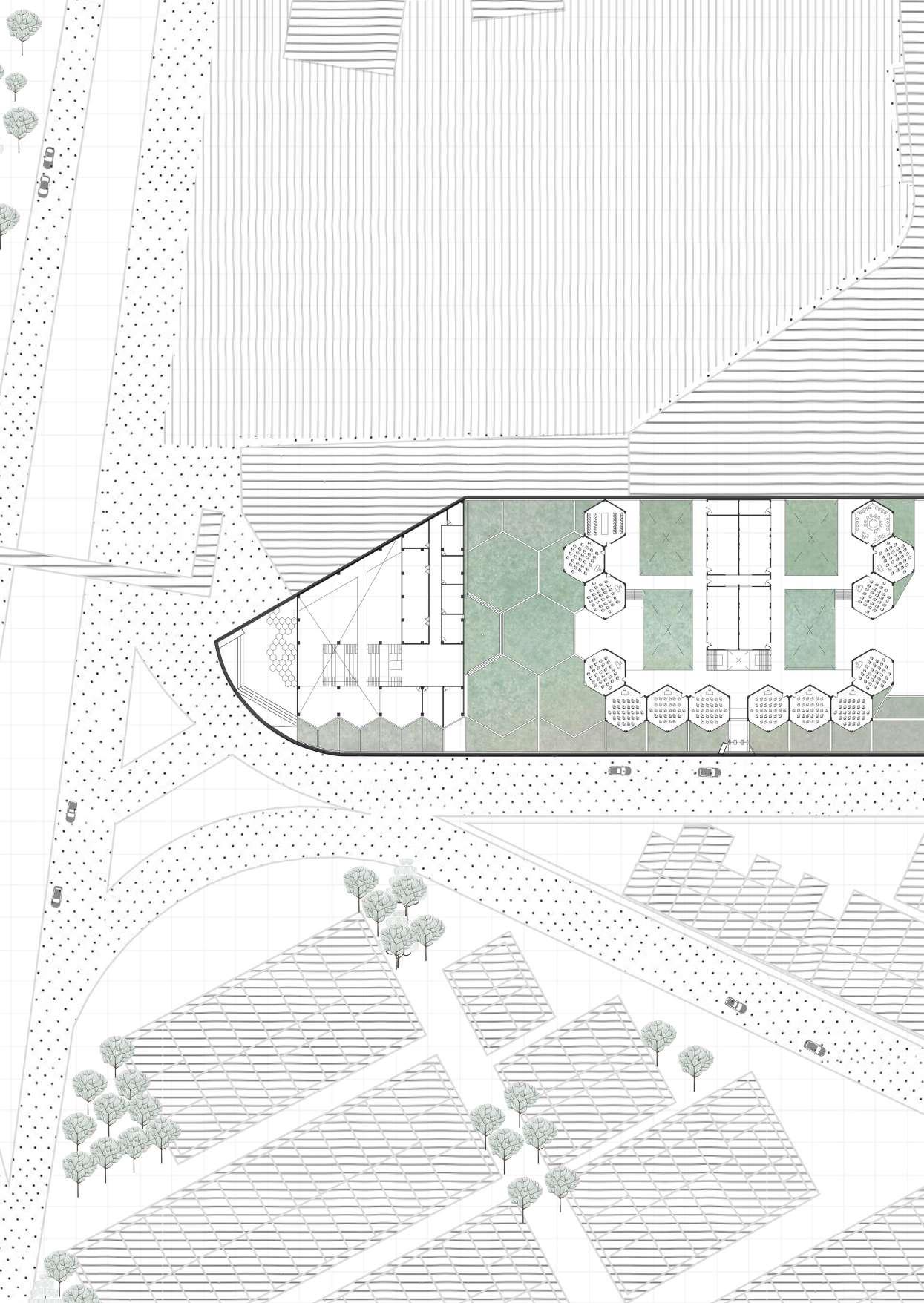
Community2 is an innovative urban and architectural project located in a rural area of Germany, which aims to slow the demographic decline of villages by fostering adaptability, connectivity and community interaction.
The project introduces a modular architectural framework that seamlessly combines flexibility and intentional design to serve a wide range of activities and residents’ needs.
By incorporating local materials and traditional design elements, the Community2 project pays homage to the region’s cultural heritage while propelling it into a more dynamic future. By transforming the spaces into multifunctional and versatile areas, the project revitalises rural communities, encourages a spirit of unity and decelerates the displacement of people from Germany’s villages.
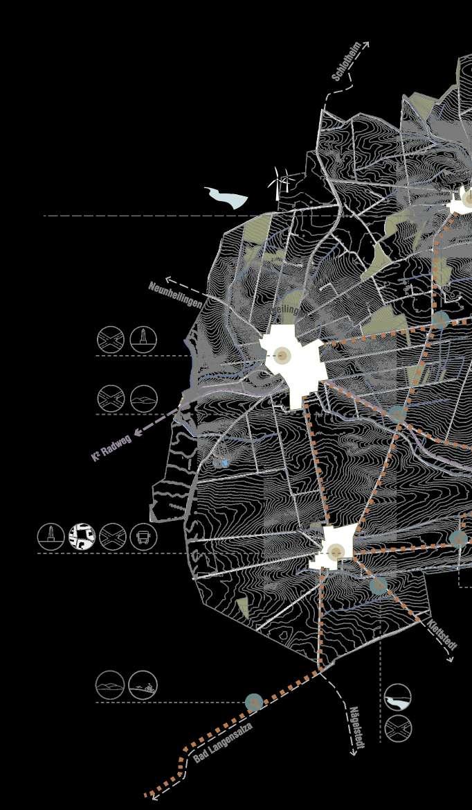
In the regional map it becomes clear our intention of interconnection within and out of Seltenrain as the routes proposed to the modules are intertwined strategically to the railway network, to the roads that best connect the village modules to each other, and to other already established bike routes.
The project comes from observing the different layers of the village region of Seltenrain such as historical and cultural features, social-demographic structures and natural aspects of the landscape. As a response to that, a modular, flexible, community-built design is proposed in the villages and in the roads that connect them.
The placement of the modules throughout the region took into account the features of places that the design would best interact with the already existing dynamics of the site and potentialize them.
In our analysis of the region we perceived that there is populational shrinkage, evasion of productive population, and generational gap of popular knowledge. So, the idea is to strengthen the village for the people who already live there, make it more compelling and attractive, so maybe the design can help enhance the sense of belonging and reduce that evasion.


Due to constant decrease of population, the demands of the community also change with the transition of demographic structure. In face of that, the proposal is a design that is flexible in use and form, so it can accompany the communities changing demands. The design will provide to the village’s inhabitants new activities and possibilities in their own community without having to go to bigger villages. The standard module can hold activities such as educational workshops, village fairs and festivities, meeting point, and commerce. In other words: it’s a multipotent space.
Co-construction detail: connections


To host all those activities the design has a wall system that could each respond in a way to the event possibilities. In pink, the entrance wall is a sliding door that accumulates all in one door leaf, leaving the entrance bigger and inviting. In brown, the multipotent wall contains a foldable table to the inside and out, and a door so the flow between the modules is possible. In blue, the pivoting door is a more restrained, less inviting passage and a place to connect visually to the outside, maybe sit on the edge.
Flexibility in arrangement


Regional scale___________________________intersection of between the 3 studied villages.

Design analysis 1:1000 1:1500


Grid based on pathways

Placement of modules

It was considered a protected vision area
Vegetation heights
variations

Pathways join Final result
Axis based on the site heights

Analysis overlay


From the village analysis, it was easily identifiable that the placement of the design must be in the most central Landscape Knot of Blakenburg village, surrounded by the busiest meeting point where is celebrated traditionally the distribution of a local Küchen (or German cake) in the Backhaus Additionally, the Gesundheitskiosken (or health kiosks) are small structures near a bus stop; they offer health services, collective advice to avoid social isolation and combine health care and welfare in rural regions as a spatially visible guidance system for a new infrastructure throughout Germany. Once taking into account these two places and the main mobility axis of the city, we chose a centric site for the design project-
Being so near, it is possible to better interact and potentialize the already exiting dynamics of the site. In Blakenburg the modules, being placed near the Backhaus, would work, mainly as an annex to the Backhaus.

Herarchized setbacks from the streets

Viewpoints considered for surroundings connections

Parallel grid based on stream and oriented placement of the first module

Internal flow created by central viewpoints

Parallel grid based on main axis and oriented placement of the second module

Overlapping of considered site features

Final placement

Final arrangement


Section A-A’
In the busy special dates in which it is open, the modules could fuction as extra places to sit and enjoy the Küchen: as market stalls to sell baked goods from the Backhaus during the regional festivals; annex to host workshops from the Backhausfreunde (bake house friends) to teach the younger members of the community their baking know-how and secure that culture being passed on; as meeting place for the elderly from the Landleben Stiftung (Country life Foundation) and their families for a sunday lunch. Formwise, the modules respect hierarchized setbacks from the streets to create intermediate spaces between design and street, like that a gradient is created. Besides that the arrangement leaves clear the main flow axis between the Backhaus and the Landleben Stiftung


¬site location: iztapalapa, mexico city, mexico
¬site area: 6,814 m 2
¬category: undergraduate 5th year | 10th semester
¬professors: María Guadalupe Morales Ramírez
¬in collaboration with Guillermo Calderón & Daniela


semester | final project

 Ramírez | Alejandro García Lara
Daniela Ortega
Ramírez | Alejandro García Lara
Daniela Ortega
Iztapalapa ('En el agua de las lajas' en náhuatl) es una de las 16 alcaldías dentro de la Ciudad de México, localizada al este de la misma.
Es el segundo lugar más poblado en el país y alberga a una quinta parte de la población capitalina destacándose por los altos contratastes en cuanto a vivienda y servicios con el resto de las alcaldías. Fue fundada entre la falda norte del cerro de la Estrella y las orillas del lago de Texcoco.
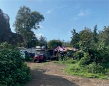
El cerro de la Estrella es un parque nacional y área natural protegida por ley desde 1938, aunque fue declarado área de conservación cuando su deterioro era muy evidente. Originalmente ocupaba mil 200 hectáreas, pero para 2011 sólo quedaban 192 mil hectáreas; se ha convertido en una zona de depredación urbana.
La zona sur del Cerro de la Estrella es la más agredida por los paracaidistas.


USO DEL SUELO DE CONSERVACIÓN CIUDAD DE MÉXICO
Desde los primeros acercamientos a la traza urbana de la CDMX, Iztapalapa fue dejada de lado convirtiéndose en “una ciudad de nadie”. El crecimiento desmedido de la población, hizo que las personas comenzaran a instalarse en terrenos desocupados del lugar.
DEMOGRAFÍA
Grupos con mayor número de personas: Grupo A: 30 a 59 años Grupo B: 15 a 29 años
DENSIDAD IZTAPALAPA 15,809
Habitantes por km²
DENSIDAD ÁREA DE ESTUDIO 14,869 Habitantes por km²
FUENTE: INEGI

IZTAPALAPA
PERÍMETRO VERDE
CERRO DE LA ESTRELLA ÁREA DE CONSERVACIÓN ANP


ÁREA DE ESTUDIO


SUELO DE CONSERVACIÓN, IZTAPALAPA, CDMX


En la época prehispánica, la civilización mexica cada 52 años se realizaba la Ceremonia del Fuego Nuevo representando el reinicio del universo. Después de la conquista y con la llegada del catolicismo, la delegación de Iztapalapa se convirtió en una de las zonas más devotas y se inició una de las tradiciones más importantes hasta ahora.
La representación de la Pasión de Cristo se hace desde 1943, convirtiendo al cerro de la Estrella en uno de los hitos más representativos de Iztapalapa, además, alberga más de 200 petrograbados e inscripciones prehispánicas y al menos 110 cuevas.
FUNCIONES URBANAS
Tanto la infraestructura como los servicios urbanos en la zona son deficientes, haciendo particular hincapié en la distribución del agua potable. Para 2020 se le otorgó un techo presupuestal a la alcaldía de 6,011.6 MDP, con el propósito de “invertir en el desarrollo y rehabilitación de infraestructura para generar mayor desarrollo económico y mejorar la calidad de vida de sus habitantes”. (Alcaldesa Clara Brugada, 2020).


SIMBOLOGÍA
Suelo de conservación Área Natural Protegida Manzanas fuera del Área de Estudio Área de estudio (5 x 5 km)
0 500 1,000 m Escala gráfica: Referencias: Espinosa, C. (2020). Infraestructura, prioridad en Iztapalapa. En: El Economista. Recuperado de: https://www.eleconomista.com.mx/estados/Infraestructura-prioridad-en-Iztapalapa-20191028-0143.html EjeCentral. (2022). Iztapalapa: estiman 1.5 millones de asistentes a la Pasión de Cristo. En: Eje Central. Recuperado de: https://www.ejecentral.com.mx/iztapalapa-estiman-1-5-millones-de-asistentes-a-pasion-de-cristo/ infobae. (2022). Cerro de la estrella en Iztapalapa: por qué era importante para los habitantes de Tenochtitlan. En: infobae. Recuperado de: https://www.infobae.com/america/mexico/2022/04/14/cerro-de-la-estrella-en-iztapalapa-por-que-era-importante-para-los-habitantes-de-tenochtitlan/


Iztapalapa se localiza en la subprovincia Lagos y Volcanes del Anáhuac. Está formado por 3 sistemas de topo formas de llanura lacustre, cubriendo casi el 96%, de la superficie. Con la expansión urbana metropolitana los ecosistemas nativos desaparecieron y en esta delegación, la fauna original ha desaparecido por completo, salvo algunas especies de murciélagos, roedores, serpientes y colibríes.
La flora en el Cerro de la Estrella y el resto del área protegida ha pasado por intentos de reforestación, aunque al hacerse con árboles no nativos de la zona, han complicado la situación para las otros árboles como el pino y el pirul.
• Temp. entre los 5 y 25 °C, media anual de 16 °C.


• Precipitación abundante en verano. 1,200 mm anuales.
• Escasa nubosidad durante la mayor parte del año.
• Granizo esporádicO en temporada de lluvia.
• Mes más cálido: marzo- mayo, mayor a 25 °C.
• Mes más frío: enero, 5 °C una mínima media.
• Viento en dirección N, velocidad promedio 7.4 km/h.
Observaciones: Hay zonas con deficiente vegetación, evitando que esta pueda ayudar a bajar el calor en verano. Refiriéndonos a algunas de las manzanas regulares, son más cortas en el sentido este - oeste y más largas en el sentido norte - sur y las casas se pegan hacia el norte para que pueda entrar algo de sol por el lado sur o viceversa, aunque esto no es necesariamente bueno. BIOCLIMÁTICA


Las manzanas fueron seleccionadas por la forma aleatoria y selectiva que tienen ya que fueron creadas por la sociedad de una manera progresiva e independiente, es decir, sin regulación en las edificaciones. Esta, muestra otro tipo de fuerza, ya que se debe a la necesidad de cambio para la obtención de una mejora continua.


SIMBOLOGÍA


Suelo de conservación Área Natural Protegida Manzanas fuera del Área de Estudio Área de estudio (5 x 5 km)
Manzanas con diferentes morfologías a estudiar
Manzanas de zona Industrial
Área en proceso de consolidacion
Manzanas de vivienda social
Área consolidada Áreas verdes (Reservas ecológicas / Parques)
Referencias: INEGI. En: Marco Geoestadístico. Recuperado de: https://www.inegi.org.mx/temas/mg/ Gobierno de la Ciudad de México. En: Portal de datos abiertos. Recuperado de: https://datos.cdmx.gob.mx/


La CDMX cuenta con uno de los mejores servicios de transporte público en el mundo, sin embargo, es evidente que siguen existiendo zonas marginadas en las que es muy complicado acceder a estos servicios. Las zonas cercanas a los puntos de movilidad pública se convierten en nodos de desarrollo, lo que resulta en el encarecimiento de la tierra.
MOVILIDAD + ESTUDIO SOCIOECONÓMICO
Posterior a la identificación de las zonas próximas a las estaciones de transporte público, se llegó a 2 conclusiones generales:
1. En la parte norte del plano, la densidad es media debido a la industria que en ella se localiza, sin embargo, al sur se observa mejor la concentración de empleo respecto a las estaciones de metro aunque en ingresos siguen siendo índices bajos.
2. Quedan zonas altamente densificadas, con niveles de empleo e ingresos medios sin ningún tipo de acceso a transporte público, aunado a lo anterior, esta zona fue identificada como Vivienda de interés social.
Escala gráfica:
0 500 1,000 m
Estaciones/Paradas de metrobus Líneas de recorrido metrobus Líneas de recorrido RTP


Densify housing within the complex and promote mixed use.
Final Proposal: social housing with an active commercial floor plan that encourages public life.

The remaining is destined to free area, the objective is to provide quality spaces for all.
Active ground floor
12 commercial spaces
969.5 m²


Ground level analysis, direct impacts and sought dynamic
Ermita Iztapalapa, being considered one of the busiest streets in the east of Mexico City, defines a characteristic of the site: its public connectivity.
The aim is to infuse this benefit into the design of the project in order to promote the social dynamics within it.

Due to the immeasurable urban growth that has taken place in Mexico City and the lack of urban planning, several parts of the city have been left without public space for its inhabitants, including this part of Iztapalapa.
Therefore, and in response to the need for housing and recreational public space, it is proposed that the use of the open space be destined for leisure activities for the inhabitants of the complex and its surroundings.
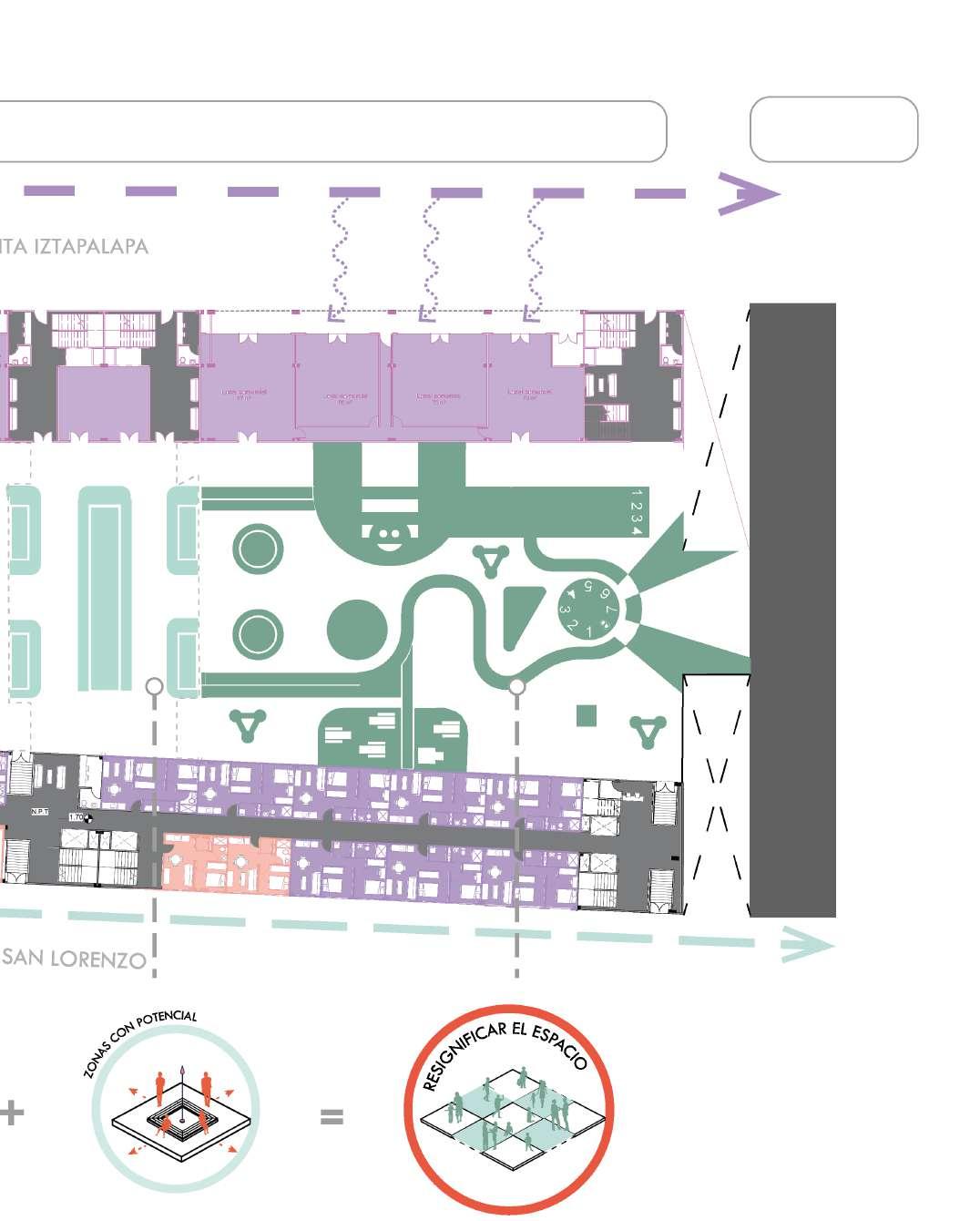
Three areas are proposed for different target groups and activities: a court with a jogging track, a living area and a playground for children.
The intention is to give a new meaning to public space and social cohesion within the dynamics that can be created from the architectural proposal.


Upper levels distribution and typologies


¬in collaboration with Gissell Sánchez Galindo Location plan Obour City,

¬category: undergraduate 5th year | 9th semester
¬site location: al obour city, egypt
¬professors: Eng. Mohamed Abed Aziz
The purpose of this exercise was to put into practice what was learned in the GIS course. For this, it was necessary to organise the data provided for the further realisation of the maps.
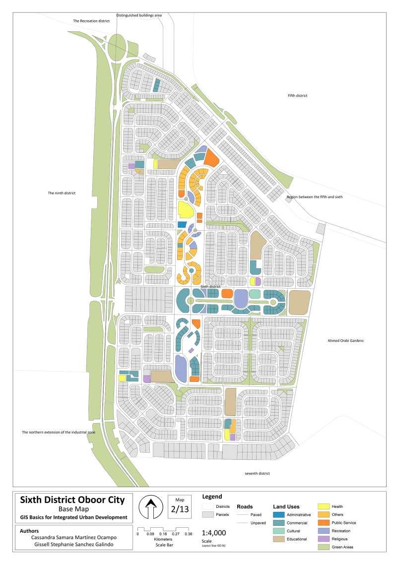


It was important to highlight the careful organisation and data integration between the layers as well as the constant communication among my team and I.


Although it was a quick mapping exercise using tools such as ArcGis, it was necessary to draw conclusions according to what was graphically presented to us about the growth of Oboor City as well as the behaviour of the services and urban uses it owns.
