Your news this week: Wildfires affecting local air quality - 2 Farmers could use some rain - 7 Lamont to supply monument pads - 10 OPINION: Let elections stay local - 4 Chipman Lamont Bus Train Accident Memorial
Proud to be an Independent CANADIAN Publication
FREE
Vol. 16, No. 34, Wednesday, July 21, 2021 www.LamontLeader.com
New drainage mapping gives County useful tool moving into future BY JOHN MATHER Lamont County councillors got their first look at the county’s Master Drainage Plan which has been in the works for several years. The study will lead to new ways in which the County can say on top of issues of drainage and road design in the county. SE Design and Consulting Inc. out of Cold Lake, had been the lead on the project and Project Engineer Steve Engman and design engineer Alyssa Gladish gave an overview of the project to council at a special council meeting July 13. In introducing the pair to council to present the study, whose purpose is “to restore the natural drainage patterns and accommodate flows across transportation infrastructure and other developments that have occurred over the past 60-70 years,” Reeve David Diduck pointed out the duration of the study took place “in probably two of the wettest years the County has had.” He added it might have been a good thing because it would have made it easy to see the natural water courses and where the water issues originate. “It’s sort of the good thing that happened,” he added. “Because this year driving around the County you would be totally surprised at the amount of water that has receded, it is almost unbelievable.” Engman admitted it had been a challenging year, but “drainage is something that can turn very quickly.” The new study maps natural drainage courses throughout the County and plots them on a computer program which can be uploaded to public works and is available to employees via their mobile devices. On top of the master plot map, culverts can then be added and other structures plus land layouts to show the proper ways to improve drainage in areas. “It’s great to be able to understand what the drainage problems are and then show them on a map. This shows that, and explains the tools available for the programs which will help the
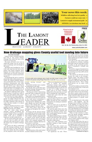
A County public works employee uses a tractor and ditch mower to clean a ditch of weeds and grasses along Range Road 202 on June 28. Photo by Jana Semeniuk County moving forward,” said Engman. He pointed out there were a number of components to the study. He said the study would show how the Rural Drainage Management Plan would work for the County. “The big part of this is determining where the water is supposed to go and how it gets there,” he explained. “Often there is an unintentional diversion which can start out very small, but as the water moves downstream it becomes a much larger problem.” He said just by draining out a little ditch officials can look at the larger impact of the channel flow and the computer program will show those. “Our study shows where all the drainages go throughout the County,” he said. SE Design did the physical design that studied the culverts in the County and examined their size and the condition of them. Another component did an analysis of the culverts and their capacities and flow rates and mapped them to the computer program. The study created a complete data base for the County to work from. “It lets you plan and work on projects that will improve the drainage in the County well into the future,” stated Engman. The third portion of the study looked at all the wetlands in the County.
“They are an important part of where water is stored,” he reported. “Sometimes farmers might want to remove those but they are so important in maintaining storage of water. In a lot of cases it’s a conflict because you might want to see those wetlands drained but at the same time you need them to maintain the water balance.” Nature had a plan where the water would go,he said. “Over the past 30 or 40 years, a ditch might have been altered or a culvert added and that has had unintended consequences of creating an unintended diversion. “We do want to try to get back to what nature intended, but that won’t happen in every case.” He said the study broke down the County into 100 hectare portions and studied the drainage in those areas. They would require culverts of a minimum size of 600mm. He added it allowed them to identify culverts and find those that were too small and some that were damaged and others totally buried. There were 7,200 catchment areas identified, leading to larger drainage areas, he said. He said study then created over 11,500 km of actual flow paths which show where water drained from rainfall and snowmelt. “It’s significant,” he said. “Those
flow paths could be natural drainage that are dry most of the year, but they drain rainfall and snowmelt so shouldn’t be disturbed.” He said 13 per cent of the County was identified as wetlands. Anything that holds water for more than 10 days according to the provincial government is considered a wetland, said Engman. He said his company had planned on studying about 800 culverts but ended up surveying more than 2,000 culverts in the County. “The culverts are obviously an issue because the water is not crossing,” Engman stated. “We looked at about 1,700 non-bridge-sized culverts from 200 mm to 1,500 mm, and less than 100 bridge-sized-culverts. Those bridge sized-culverts are on major water courses.” He said the database included all the culverts and whether they would need to be replaced or not. He pointed out every culvert on the GIS system states its size and location. This allows county workers to see the total surrounding drainage patterns for all the culverts so they can see if it is working properly in specific conditions. “It’s an important part of the whole process,” said Engman. “All the drainage courses, ditches, everything is in the database. So when you try to understand what is happening with a situation you can see wetlands and culverts and determine how it all relates to flooding and indicates the complete drainage area to alleviate the issue. “There are then formulas to determine the specific drainage capacities for specific areas,” he added. It would show when, if possible, a culvert could be replaced with a larger one, Engman added. He said the maps allow the user to see ways water had been diverted from the original water course over the years and why problems are happening now. “When people say it never used to be like that,” said Engman “It’s because something at sometime was diverted.” Continued on Page 11