GEOHAZARDS, ENGINEERING, AND INFRASTRUCTURE Earthquakes, landslides, floods, tsunamis, and volcanoes cost lives and billions of dollars. Geoscientists seek to understand the processes responsible for these geohazards to assist in disaster preparedness. Geoscientists also provide critical knowledge about the land and availability of local earth materials to ensure the wise location and safe development of infrastructure.
DID YOU KNOW
that a layer of clay can be ‘sensitive’? Underlying parts of Ontario and Quebec is a 15 to 100 metre-thick layer of clay deposited in the ancient Champlain Sea. Geoscientists have studied this clay and determined that because of its distinctive physical and chemical characteristics, it is ‘sensitive’ to river erosion, earthquakes, and human disturbance, and subject to sudden failure, which can cause catastrophic landslides. More than 250 collapses related to this clay have been identified; the most catastrophic was in 1908 at Notre-Dame-de-laSalette, Quebec, where 33 lives were lost.
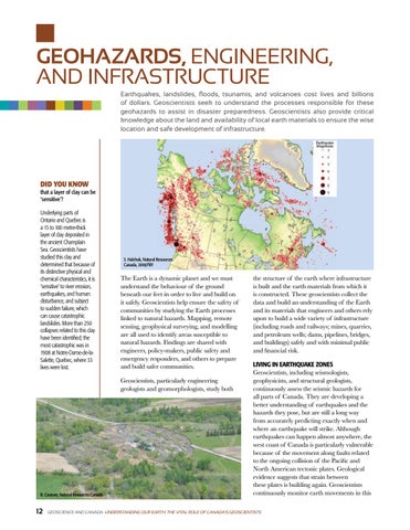
S. Halchuk, Natural Resources Canada, 2018/FBY
The Earth is a dynamic planet and we must understand the behaviour of the ground beneath our feet in order to live and build on it safely. Geoscientists help ensure the safety of communities by studying the Earth processes linked to natural hazards. Mapping, remote sensing, geophysical surveying, and modelling are all used to identify areas susceptible to natural hazards. Findings are shared with engineers, policy-makers, public safety and emergency responders, and others to prepare and build safer communities. Geoscientists, particularly engineering geologists and geomorphologists, study both
R. Couture, Natural Resources Canada
12
the structure of the earth where infrastructure is built and the earth materials from which it is constructed. These geoscientists collect the data and build an understanding of the Earth and its materials that engineers and others rely upon to build a wide variety of infrastructure (including roads and railways; mines, quarries, and petroleum wells; dams, pipelines, bridges, and buildings) safely and with minimal public and financial risk. LIVING IN EARTHQUAKE ZONES Geoscientists, including seismologists, geophysicists, and structural geologists, continuously assess the seismic hazards for all parts of Canada. They are developing a better understanding of earthquakes and the hazards they pose, but are still a long way from accurately predicting exactly when and where an earthquake will strike. Although earthquakes can happen almost anywhere, the west coast of Canada is particularly vulnerable because of the movement along faults related to the ongoing collision of the Pacific and North American tectonic plates. Geological evidence suggests that strain between these plates is building again. Geoscientists continuously monitor earth movements in this
GEOSCIENCE AND CANADA UNDERSTANDING OUR EARTH: THE VITAL ROLE OF CANADA’S GEOSCIENTISTS