ABOUT ME
I am Cameron Hand, a graduate from UGA’s Bachelors of Landscape Architecture program. I came into the University as an intended civil engineering major, but soon discovered landscape architecture which helped me to pursue my passions of ecological and historical preservation. I also graduated from the University’s sustainability certificate program. In my certificate capstone project, I combined my urban planning skills with principles of sustainability to create a plan to increase the resilience of Athens, GA. I enjoy studying history, especially how early civilizations adapted to and manipulated their environments. I believe that learning from these practices will be key in creating sustainable developments in the future. I love to travel and document my travels through photography, sketching, and journaling. I also like to play guitar, and even formed a small band for a charity music festival benefitting a local food bank. I am very active, and especially enjoy hiking, snowboarding, and playing golf.
• Taught campers leadership skills through the YMCA’s Advanced Leadership Academy
•
• Awards: “Best Student Project” at the 2023 Georgia Climate Conference

•
•
APARTMENTS


MASTERPLANNING


PHASE 2: LIFT STATION + HORIZONTAL LEVEE


If there is heavy rain during high tide, a lift house will lift stormwater above the tide line. This lift station will use a vertical-axis wind turbine to provide supplementary electricity as well as a backup power source in case of power grid failure. The newly raised outfall will drain into a horizontal levee, which acts as a sea level rise defense that also filters stormwater runoff and allows for marsh migration. The raised roadway acts as a secondary, stronger flood defense.

MASTERPLAN

Stage one of the adaptation plan is designed to address current flooding problems in the bowl and protect that area from sea level rise. In addition it will provide data on the efficacy of different flood defense strategies. Based on the success of the horizontal levee and the stormwater retention in phase 1, further horizontal levees and stormwater retention basins can be prescribed for an island-wide adaptation plan.
COMMUNICATION + COMPROMISE


While the implementation of stage one does not require any households to be disturbed, the same can not be said for the master plan. The waterfront properties on Miller Ave., Chatham Ave. and 6th St. are going to be directly impacted by the flood defense system, so it is crucial that homeowners are consulted. While the master plan shows prescribed defenses, Stakeholder meetings with coastal residents, along with data provided by stage one, should be used to determine the best course of action. There are three primary strategies in dealing with sea level rise: de fend, adapt, and retreat. Guided by data and community input, Tybee Island should decide which strategies to imple ment on each section of coastline.
REDUCING + RAISING COASTLINE


The proposed plan would reduce the length of coastline to be defended by over 50%. This minimizes the environmental and economic cost of creating a comprehensive levee system to protect the Island.
PRESERVING MARSH + WATERWAYS


The rotating tide gates are inspired by the Thames River barrier and would leave the waterway’s flow completely unimpeded while open. This would preserve the complex ecology of the marsh and allow light watercrafts to continue to use the waterway. The gates will use smart technology to react in real time to the complex fluctuations in tide. The two major flood gates are strategically located at natural bottlenecks in the marsh, in order to protect the most vulnerable households with minimal marsh disturbance.

3. WATERFRONT AMPHITHEATER
4. MONTEZUMA LIBRARY
TRAIL NETWORK MASTERPLAN


HISTORIC TRAIL NODES
1. RAILROAD DEPOT AND CARNEGIE LIBRARY

2. HISTORIC DOWNTOWN MONTEZUMA
3. BEAVER STREET AND JAIL HOUSE PARK
4. CLOCK AND FIRE BELL
5. FENTON CEMETERY
6. HISTORIC CHURCHES
7. HISTORIC HOUSES
8. VOLATILE HOUSE
9. MOUNT PLEASANT CEMETARY
ECOLOGICAL TRAIL NODES
1. BEAVER CREEK BOARDWALK
2. LONGEAF PARK
3. BEAVER CREEK BRIDGE 1
4. POND TRAIL LOOP
5. PECAN ORCHARD
6. FLINT RIVER BOARDWALK
RECREATIONAL TRAIL NODES

1. UNITY PARK
2. DISC GOLF FRONT 9
3. DISC GOLF BACK 9
4. MOUNTAIN BIKE TRAILS
5. CAMPGROUND/FESTIVAL SITE
6. BEAVER CREEK FLOAT LAUNCH
7. D.F. DOUGLASS BASKETBALL COURT
8. WILLIE SNEED POCKET PARK
CULTURAL TRAIL NODES


1. BEAVER CREEK AMPHITEATER
2. LONGLEAF PARK STAGE

3. WATERFRONT AMPHITHEATER
4. MONTEZUMA LIBRARY
5. D.F. DOUGLASS COMMUNITY CENTER
LEGEND
HISTORIC TRAIL
NATURE TRAIL ROADS
HISTORIC BUILDING
PUBLIC BUILDINGS
PRIVATE RESIDENCES
5. D.F. DOUGLASS COMMUNITY CENTER
LEGEND HISTORIC TRAIL NATURE TRAIL ROADS HISTORIC BUILDING
Montezuma is a small city in middle Georgia suffering economically since the flood and its population of Montezuma’s historic and ecological assets. The trail
PUBLIC BUILDINGS
PRIVATE RESIDENCES
HISTORIC TRAIL TRANSECT


Longleaf pine forests used to cover most of Georgia’s Coastal plain, but the ecosystem has been almost entirely eiliminated. Longleaf pines evoloved to coexist with fire, which they need to prevent other species from taking over their canopy. In recent history, humans have suppresed fires and longleaf pinea along with them. This park uses Longleaf Pines, along with typical understory plants to create a beautiful and functional savanna. This park is located in downtown Montezuma, but in a position that will allow it to safely burned. The roads that surround the park create fire breaks that help in conducting controlled burns. The mowed pathways through the grassland also act as fire breaks and create unique walks leading to secluded seating areas surrounding specimen trees. The diverse mix of grasses and flowers will create a beautiful tapestry that will attract people and pollinators alike.


AMPHITHEATER + BOARDWALK
PROJECT GOALS
- CONNECT PEOPLE TO LOCAL ECOLOGY + HISTORY
- PROVIDE AREAS FOR RECREATION AND CULTURAL EXPRESSION
- CREATE + RESTORE NATIVE HABITATS AND ECOSYSTEMS
- PROVIDE ACCESS TO BEAVER CREEK + THE FLINT RIVER
This ADA accessible amphitheater and boardwalk accomplishes all of these goals and more. It creates opportunities to interact with Beaver Creek, participate in passive recreation, and enjoy cultural performances, all while improving the ecological and physical resilience of the creek’s oft-flooded banks.


RESIDENTIAL DESIGNS


HAMPTONS HOUSE
DESIGN STATEMENT


This residential design aims to blend the formal and agrarian aspects of a Hamptons’ landscape, creating a series of unique and memorable experiences as one moves through the property. The design was implemented in the summer of 2023
This residence is located in Water Mill, New York, one of the several communities that make up The Hamptons on Long Island. This specific property backs up to a beautiful horse pasture, so the landscape is designed to frame this view and complement the agrarian context, along with the contemporaray rural architecture of the house.

CLOISTER GARDEN ELEVATION


POOLHOUSE ELEVATION BACKYARD ELEVATION


GREENMILL APARTMENTS
DESIGN STATMENT:

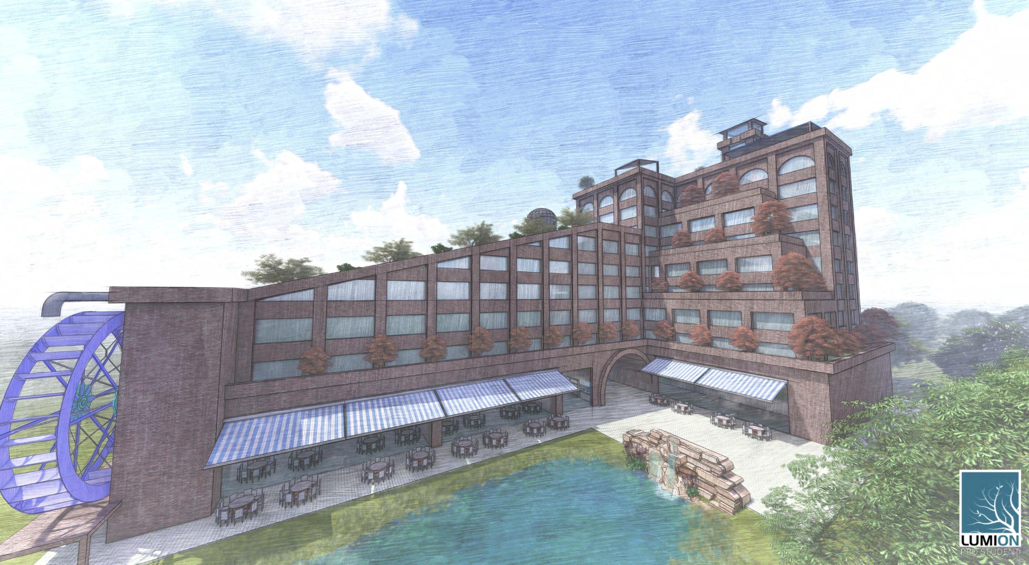
The primary goal of this high density, mixed use residential building is to mitigate environmental impact and the utilities costs for residents through sustainable design. The building uses green roofs and deciduous trees to reduce urban heat island effect along with solar panels for supplementary electricity. The majority of the green roof surface area is used for food production in the interest of supplying residents with cheap and/or free organic produce (based on yield and demand). The building has an extensive rainwater and grey water collection system which provides water for crop production. A large constructed wetland acts as a water-purifying buffer for the Oconee river while simultaneously creating an aesthetic, waterfront landscape, complete with restaurants and a functioning water wheel. The overall design of the property is an homage to the old mill building that houses the UGA school of social work. Red brick facades and a railroad trestle inspired bridge create a rustic feel, while modern rooftop amenities with river views create a unique and dualistic living experience.


WETLAND
The constructed wetland allows for a waterfront dining experience without disturbing the existing riparian buffer of The Oconee River. The wetland also helps to protect the river quality by naturally filtering water from the surrounding watershed. The patio area around the wetland provides a serene oasis for residents and members of the public. The area is sheltered from the busy roads that border the property, and the sound of traffic is replaced by sounds of flowing water and wildlife.


ROOFSCAPE
The roof of the building is dedicated to recreation. The elevated workout platform provides fantastic views and a natural breeze while exercising. Solar panel structures provide shade, energy and rainwater harvesting. The rain that falls on the panels is collected using gutters and stored in a cistern. This water can be used to irrigate the trees on the rooftop and terraces below. The naturalistic rooftop pool is designed to mimic the constructed wetland at the bottom of the building. The pool uses a wetland filter to reduce the need for harsh chemical treatments.
PARK + GARDEN DESIGNS


AGRIHOOD PARK + GARDEN
ECOLOGICAL OBJECTIVES
- Maintain or improve existing ecological function of the site
- Maximize biodiversity by creating a matrix of native habitats
- Minimize energy and water consumption
- Minimize stormwater runoff and pollution
RECREATIONAL OBJECTIVES

- Provide opportunities for active and passive recreation
- Provide an extensive network of mixed use trails
- Provide communal areas for gatherings of all sizes
- Provide an amphitheater for large events
EDUCATIONAL OBJECTIVES
- Educate patrons on the ecology of Georgia and its habitats
- Educate patrons on the agricultural history of Georgia
- Educate patrons on horticulture by growing their own food
- Educate patrons on watersheds and wetland function
CONSTRUCTED POND WITH WETLAND FILTER MEADOW

MULTICULTURAL REFLECTION GARDEN
While my park emphasizes local, environmental concepts, my garden will focus on international, cultural aspects. My garden will be a prayer/meditation garden that works on uniting different cultures and religions through nature. The garden features 5 reflection ponds all fed by one central water source, each one representing one of the 5 major religions. The central water source surrounds a large tree that reflects nature’s connection to humanity and religion.


CHRISTIANITY
The Christian section of the garden is inspired by a traditional European Cathedral. These cathedrals were designed to mimic the old-growth forests that were sacred to the pre-Christian inhabitants of Europe. The cross-shaped reflecting pool is surrounded by large, heavily trimmed cedars that create a tall, dense canopy. In the clearing at the center of the garden, flowers with Christian symbolism are planted to imitate a traditional cloister garden.
ZEN BUDDHISM
This section of the garden is inspired by a traditional Japanese Zen garden. The raked sand of these gardens was used to imitate water, which the monks could not justify wasting. This garden uses water, like the gardens of the Song dynasty, instead of sand to create a dramatic vista. Behind the pagoda there is a secluded place for reflection underneath a tree. This tree is supposed to represent the bodhi tree which Buddha meditated under for several days. The winding path through the bamboo symbolizes Buddhas journey towards enlightenment.

MANGROVE PARK DESIGN CHARETTE


DESIGN STATEMENT


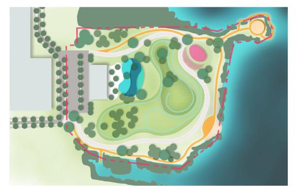
For this project, we were inspired by the flow and movement of the tide and the coastal ecology of southern Florida. The site provides an exciting experience as users move through a shady forest into an open landscape that uses organic, rolling topography to simulate the ocean. Our design allows users to interact closely with the mangroves without disturbing their crucial habitat by using a raised boardwalk. At its core, our project aims to provide a space for visitors to experience and learn about Florida’s beautiful habitats and ecosystems.
Our design is inspired by the diverse and beautiful marine habitats of southern Florida. Many of Florida’s aquatic species start their lives in sheltered mangrove forests, and slowly progress into coral reefs and deeper waters as they mature. Our site mimics this progression by surrounding visitors with dense vegetation as they enter the site. As users move east towards the river, the park opens into an undulating landscape of organic landforms, designed to mimic the waves of the ocean. These earthen waves provide flood defense, enclosure for the coral reef playground, and drama as one walks over or around them into a completely different landscape. The main wave slowly rises from the riverbank, creating a natural amphitheater surrounding an oyster-inspired stage. The other side of the wave “crashes” towards the playground and splash pad area, creating an enclosed play area full of colorful, coral-inspired structures for children to climb on. The second level creates a play area for younger children which includes a jungle gym based on the arching roots of the mangrove tree. This playground is closest to the café seating so that parents can sit and watch over their children.
The site has two primary pathways going around the exterior of the site, a wide, paved walkway, and a raised boardwalk. The paved walkway doubles as an emergency access and service road to create a safe, accessible site. The boardwalk provides users access to the kayak launch, the beach, and the pavilion. Users can walk this raised path for an immersive experience in the mangroves surrounding the site, without damaging their tree roots. There is also a system of secondary pathways that wind around and up the mounds, flowing up the grade and through the shade trees surrounding the path. These pathways culminate at the top of the site
MANGROVE PAVILION
This raised pavilion, inspired by the roots of a mangrove tree, provides visitors with panoramic views of the coastal landscape. It is designed to make patrons feel as though they are moving through the root system of a giant mangrove tree, while simultaneously being surrounded by a canopy of real mangroves.


OYSTER STAGE
This quick sketch demonstrates what an oysterinspired stage might look like. This stage serves as the focal point of the wave-like amphitheater.


HAND GRAPHICS + SKETCHES


