Joint Camden County Comprehensive Plan 2023-2027

We would like to thank all those who participated in and assisted with the development of the Joint Camden County 2023 Comprehensive Plan. The content of this plan is the result of a 14-month process involving three local governments, dozens of meetings, and over 40 stakeholders. The plan was further enhanced by the generous input provided by members of the public at public hearings, public listening sessions, and through the online survey. We are extremely grateful for the support we received during the process and look forward to working with these local governments on the implementation of this plan.
Camden County Board of Commissioners
Ben Casey, Chairman
Lannie Brant, Vice Chairman
Martin Turner
Trevor Readdick
Jim Goodman
Kingsland City Council
Dr. C Grayson Day, Mayor
Alex Blount, Mayor Pro Tem
Farran Fullilove
James Galloway
Kristy Chance
St. Marys City Council
John F. Morrissey, Mayor
Artie Jones Jr.
Steven Conner
David Reily
Allen F Rassi Jr.
Lisa James
Steering Committee
Cindy Daniels, Camden County Planning & Zoning Coordinator
Lannie Brant, Camden County Commission
Trevor Reddick, Camden County Commission
Robbie Cheek, Camden County Planning Commission
Alan Rainer, Camden County Planning Commission
Joey Yacobacci, Camden County Director of Planning & Development
Kenneth Hughes, St. Marys Community Development Director
Justin Geedy, St. Marys Assistant Community Development Director
Bobby Marr, St. Marys Public Works Director
Les Warner, St. Marys Planning Commission Chair
Charlie Williams, St. Marys Assistant City Manager
Lee Spell, Kingsland City Manager
Scott Kimball, Kingsland Planning & Zoning Director
Tonya Harvey, Kingsland Economic Development
Camden County Stakeholder Committee
Barry Reed
Brandon Chonko
Greg Reid
Elvis Randolph
Joss Josselyn
Kevin Barkely
Shalana McNamee
Martin Turner
Matt Jordan
Terral Brazell
Chuck White
Shawn Boartright
Lili High
Daniel Wheeler
Tommy McGraw
Kingsland Stakeholder Committee
Alison Shores
Angie Halliwell
Dr. Leon Washington
Justin Whitefield
Matthew Hooks
Kathy Dixon
CB Yadav
Paul Chamberlin
Mayor Day
Farren Fulilove
Brian Parker
Ronald Sawyer
Bill Gross
Jolene Anderson
Steven Sainz
Bryant Shepard
Chief Evans
Chief Smith
Dr. James McCarter
Kris Cagle
Pastor Mike Sanes
Terry Landreth
Paul Pleasant
Marys Stakeholder Committee
Tanya Glazebrook
Terry Landreth
Fred Mercier
Melvin Taylor
Jay Lassiter
Teddie Lockhart
Les Warner
Lloyd Streit
Wiley King
Russ Byrd
Taylor Mobbs Coastal Regional Commission
Allen Burns, Executive Director
Dionne Lovett, Assistant Executive Director
Aaron Carpenter, Director of Planning & Government Services
Meagan Jones, Planning Manager
Hannah Mendillo, Regional Planner
Ian Kellett, Regional Planner/GIS Analyst
Camden County and the Cities of Kingsland and St. Marys have joined together with the Coastal Regional Commission (CRC) to prepare the Joint Camden County 2023 Comprehensive Plan. Comprehensive planning is an important tool for promoting strong and healthy communities. Comprehensive plans are centered around a vision and a set of goals that express a desired future. Camden County, the City of Kingsland, and the City of St. Marys have each developed separate visions, goals, and short-term work plans that they intend to utilize to for collaborate implementation.
Camden County is a welcoming community that sustains a small-town atmosphere while embracing future growth opportunities. Camden County has a commitment to planned future development, promoting economic opportunity, and supporting a strong workforce. Camden County’s goals include equal access to goods and services, maintaining a sense of community, workforce development, and working towards county resilience.
The City of Kingsland is a family-friendly community that offers a great place to live and boasts great schools, a growing population, and small-town charm. Kingsland welcomes economic and residential growth while still aiming to support its unique identity. The City of Kingsland is focused on achieving a diverse economy, protecting the natural and historic character, promoting attainable housing, addressing infrastructure needs, and quality service from elected officials. The City of St. Marys’ community vision and goals have been developed since 2017 and revised and updated to focus on improving overall comprehension, clarifying intent, and consolidating similar phrases. The Community Vision of the City of St. Marys is therefore supported by goals that encompass economic prosperity, healthy and happy communities, efficient land use, and regional cooperation.

AADT - Annualized Average Daily Traffic
CRC - Coastal Regional Commission
ECG - East Coast Greenway
NSB - Naval Subamarine Base
SR - State Route
SWOT - Strength, Weakness, Opportunity, Threat
USACE - United States Army Corp of Engineers
USBR - United States Bike Route
Tables and Figures
Table 1.1.1: Camden County Population Statistics
Figure 1.1.1: Camden County Racial Breakdown
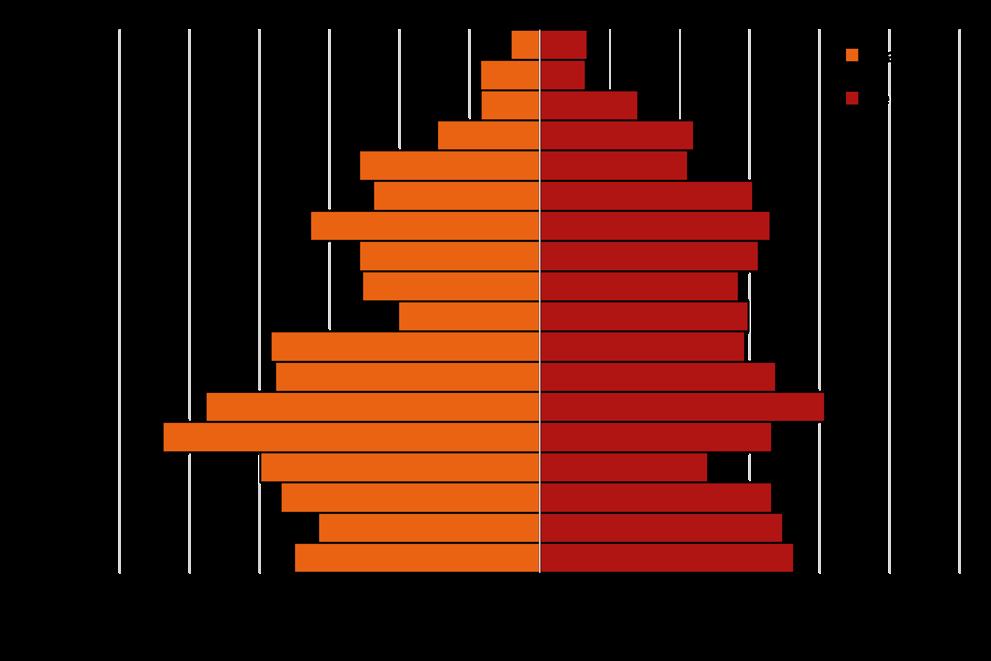
Figure 1.1.2: Camden County Population Pyramid
Figure 1.2.1: Camden County Population Projections, 2021-2060
Table 3.1.1: Camden County Character Areas
Table 3.3.1: St. Marys Character Areas
Figure 4.0.1: Camden County SWOT Analysis
Figure 4.0.2: Kingsland SWOT Analysis
Figure 4.0.3: St. Marys SWOT Analysis
Figure 4.1.1: Survey Satisfaction Ratings
Figure 4.1.2: Survey Word Cloud
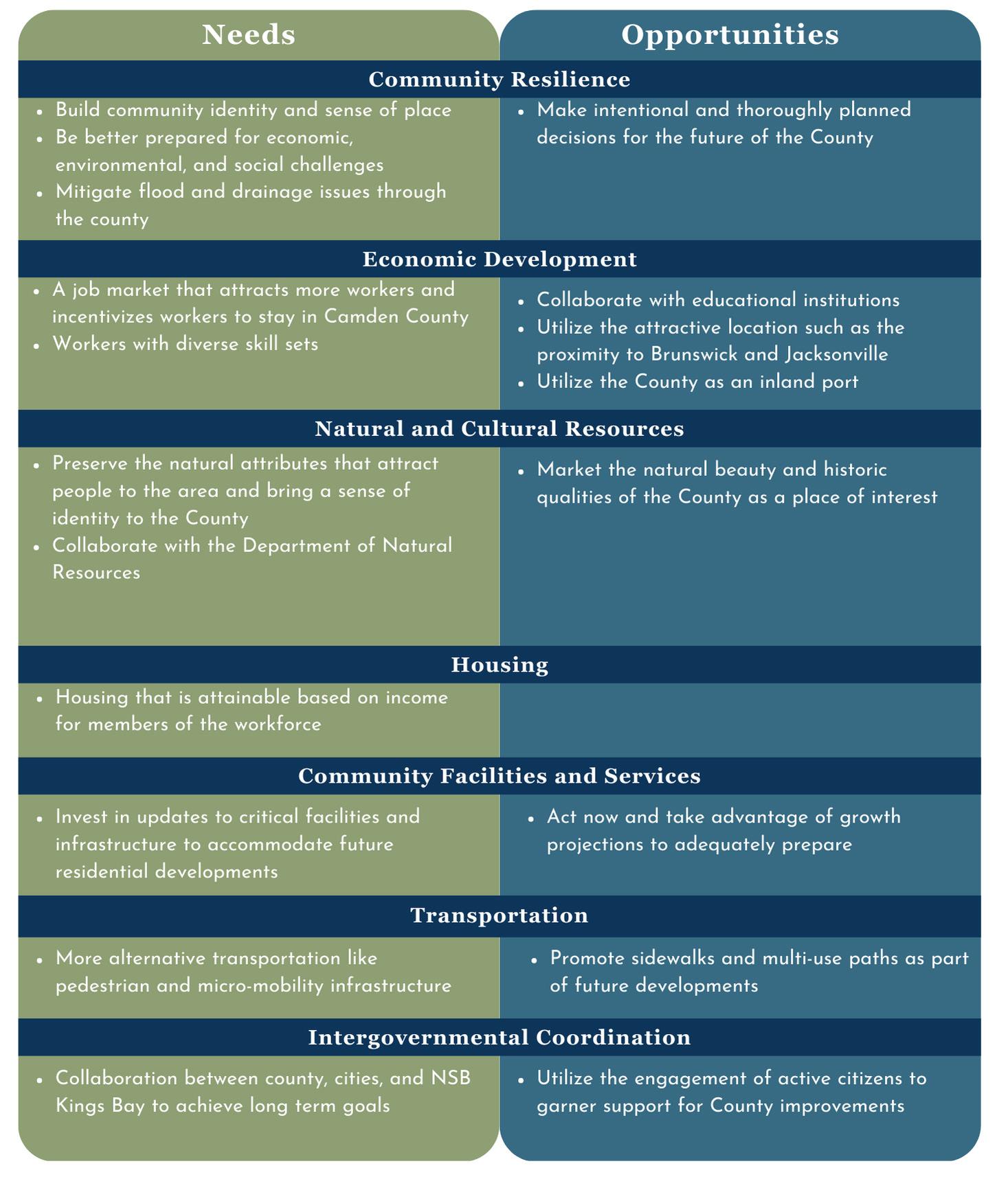
Figure 4.2.1: Camden County Needs and Opportunities
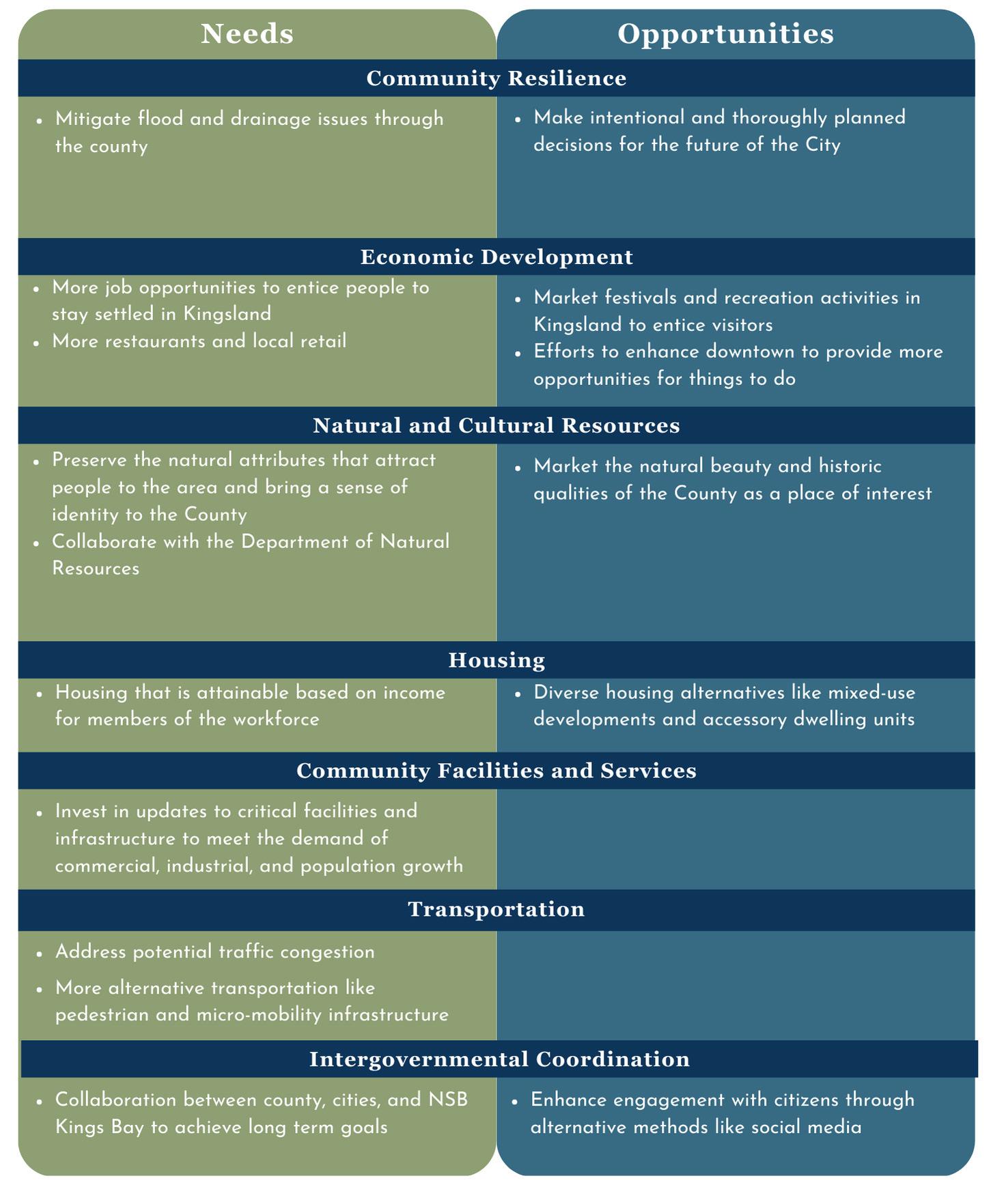
Figure 4.2.2: Kingsland Needs and Opportunities
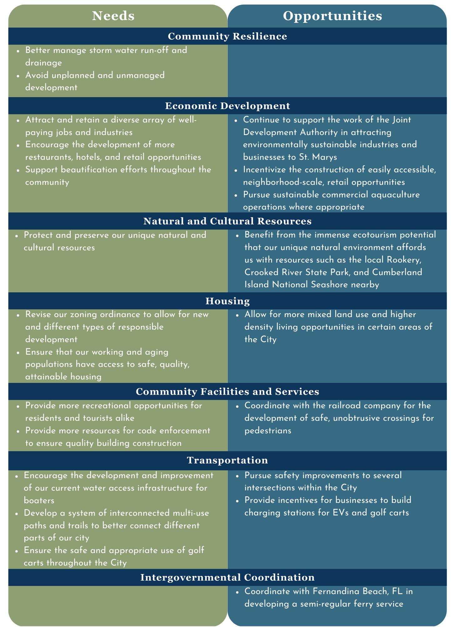
Figure 4.2.3: St. Marys Needs and Opportunities
Figure 6.1.1: Camden County Housing Units by Type
Figure 6.1.2: Camden County New Privately Owned Housing Unit Authorizations
Table 6.1.1: Camden County Housing Units
Figure 6.2.1: Camden County Typical Home Value
Table 6.2.1: Camden County Housing Costs
Table 6.3.1: Camden County Housing Cost-Burden by Location
Table 6.3.2: Camden County Housing Cost-Burden by Tenure
Table 6.4.1: Camden County Jobs-Housing Balance
Table 7.4.3.1: St. Marys Traffic Numbers on Busiest Roads
Figure 7.4.4.1: St. Marys Vehicle Collisions by Severity, 2013-2021
Figure 7.4.4.2: St. Marys Vehicle Collisions by Type, 2013-2021
Table 7.4.5.1: St. Marys Commuting Types, 2020
Table 7.4.5.2: St. Number of Vehicles Available for a Working Household, 2020
Figure 7.4.5.1: Where Do St. Marys Residents Work? 2019
Figure 8.1.1: Camden County Employment by Industry
Table 8.1.1: Camden County Occupation Type
Table 8.1.2: Camden County Class of Labor Force
Figure 8.1.2: Camden County Employment Statistics
Table 8.1.3: Camden County Labor Force Employment Locations
Table 10.2.1: Camden County Vulnerable Populations
Table 10.2.2: Camden County Percent of Households without Access to a Vehicle
Table 10.2.3: Camden County Income and Poverty Statistics
Table 10.2.4: Camden County Economic Inequality
Table 11.1.1: Camden County Report of Accomplishments
Table 11.1.2: Kingsland Report of Accomplishments
Table 11.1.3: St. Marys Report of Accomplishments
Table 11.2.1: Camden County Short-Term Work Plan
Table 11.2.2: Kingsland Short-Term Work Plan
Table 11.2.3: St. Marys Short-Term Work Plan
Located along the southeast coast of Georgia, Camden County encompasses nearly 782 square miles (636 square miles of land area) of the Georgia lowlands and surrounding waters. The natural environment is comprised primarily of flooded and unflooded woodlands, marine estuaries, and dozens of islands and hammocks, including the Cumberland Island National Seashore. Camden County is bounded to the north by the Little Satilla River which separates it from Glynn County and the Brunswick Metropolitan Area. To the south it is bounded by the St. Marys River marking the dividing line between Georgia and Florida. To the west are the counties of Charlton and Brantley. To the east is the Georgia Bight, part of the Atlantic Ocean and the principal provider for local fisheries looking to harvest oysters, shrimp, and an assortment of deep-sea fish species. Founded in 1777 as one of the eight original counties in Georgia, Camden County contains three incorporated communities today, Kingsland, St. Marys, and Woodbine.
Kingsland was founded in 1908 by William Henry King and developed first as a passenger rail stop for the north-south rail line running from Florida up the east coast. As a result of this strategic location, businesses and industries catering to travelers began to crop up along the now historic downtown. With the development of US-17 through the city center and I-95 less than 2 miles to the east, the City has become a well-traveled transit stop for trucks and vacationers touring the east coast. With Jacksonville 40 minutes to the south, and Brunswick 40 minutes to the north, the town has also become a desirable location for residents and tourists alike who are looking to find a place to land away from the lights and sounds of the city.
St. Marys was founded in 1792 near the site of a former 16th century Spanish colony, one of the northernmost Spanish settlements on the Eastern Seaboard. It lies on the banks of the St. Marys River, the dividing line between Georgia and Florida, and has served as a seaport serving small fishing ships and travelers since its inception. It has easy access to the Atlantic Intracoastal Waterway, providing ships traveling up and down the Eastern Seaboard with a safe, navigable route inland to avoid the turbulent waters of the open Atlantic. St. Marys serves as a convenient stopping location for ships traveling to or from Florida with several bed and breakfasts within walking distance of the marina. St. Marys is accessed by road via State Route (SR) 40 and St. Marys Road, both of which connect to I-95 approximately 10 miles west of downtown.
Woodbine was founded in 1908 on the banks of the Satilla River approximately 10 miles north of Kingsland. US 17 runs through the center of the City and I-95 bypasses it several miles to the east giving access to Woodbine and the surrounding area through exit 14. The City has operated as the county seat of Camden County since 1923.
Camden County also contains Naval Submarine Base (NSB) Kings Bay, founded in 1978 and today is home to approximately 5,000 active-duty personnel as well as an additional 3,500 civilian contractors. NSB Kings Bay has been the primary staging ground for the Atlantic-based Ohio-class nuclear submarines since the submarines entered service in 1981. Looking forward into the future, NSB Kings Bay will serve a similar role for the upcoming Columbia-class submarines, designed to replace the Ohio-class. As of 2023, the base has recently completed many of the necessary retrofits to accommodate the new class of submarines. They are expected to enter service sometime around 2030. Many of the residents of St. Marys work at the base, in related industries, or have since retired from the service but elected to live nearby after being discharged.
Camden County is home to 54,768 people as of the 2020 census, an increase of 8.4 percent from 2010 numbers, which is slightly lower than Georgia’s 10.6 percent rate of growth over the same period. The majority of people in Camden County live in the southern third within and surrounding the municipalities of Kingsland and St. Marys. This has also been the area experiencing the most growth over the past 10 years.
As shown in Figure 1.1.1, the American Community Survey estimates that as of 2020 Camden County is 69.6 percent Non-Hispanic White, 17.8 percent African American, seven percent Hispanic, with the remaining 5.6 percent being comprised primarily of Asian, Native American, those identifying as some other race, or those identifying as belonging to two or more races.
The median age of Camden County is 33.3 years old, one of the youngest in the region, and is primarily the result of the young workforce, along with their families, employed by NSB Kings Bay and the surrounding industries. The largest age cohorts are those between ages 20 and 40 with a noticeably large population under the age of 18 as well.

The Governor’s Office for Planning and Budget’s 2020-2060 population projections show Camden County adding approximately 13,000 people in the next 40 years as their growth rate slowly decreases from 0.6 percent annually today to around 0.3 percent in 2060, as shown in Figure 1.2.1. This will bring the total population in the county to approximately 68,000 by 2060.

The Joint Camden County Comprehensive Plan is a living document that is updated and shaped by stakeholder engagement and implemented through the local governments. It is a policy guide for making community decisions and future development of Camden County for the 2023 to 2027 period.
The goals and policies within the Comprehensive Plan are designed to help make Camden County healthier, equitable, resilient, and intentional.
The Joint Camden County Comprehensive Plan is a five-year update as required by “The Minimum Standards and Procedures for Local Comprehensive Planning” adopted by the Georgia Department of Community Affairs. In meeting with these standards, this plan enables Camden County and the cities of Kingsland and St. Marys to maintain their Qualified Local Government (QLG) status, making them eligible to receive certain types of state funding. This plan assesses the current state of Camden County and establishes a foundation to support community visions.
Public outreach efforts began in early summer of 2022 with public hearings to announce the comprehensive planning process. A joint steering committee, individual stakeholder committees, a community survey, and public listening sessions contributed to the development of the Joint Camden County Comprehensive Plan. Sign-in sheets and public engagement documents can be found in Appendix B
Public hearings were advertised in the local newspaper, the Tribune & Georgian. Public hearings were intended to announce major steps in the comprehensive planning process and provide a platform to answer questions from the public.
A joint steering committee was created, made up of local government officials from each municipality. The joint steering committee met twice and were consulted throughout the process about plan developments. The steering committee selected the members of the stakeholder committee.
Each local government had their own stakeholder committee, made up of people who live or work in their respective municipality. Stakeholder committees are intended to be representative of the community. Stakeholders came from diverse special interests including, but not limited to, affordable housing, private development, public works, recreation, and business owners.
The Joint Camden Community Survey was launched on January 19th and remained open until March 20, 2023. Local governments advertised the survey on their websites and social media. The survey was hosted on the Coastal Regional Commission’s website. Stakeholders were also encouraged to hang the survey flyers in their business and offices.
Public listening sessions provided a casual way for community members to speak with CRC staff in an open forum and take paper surveys.
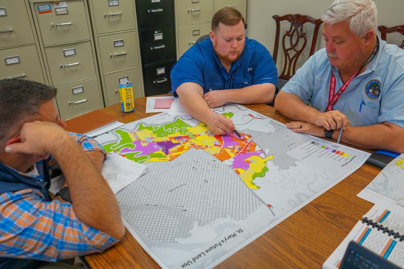
Camden County, Kingsland, and St. Marys each developed individual visions and set goals to achieve and support those visions. The goals represent recurrent themes identified during community discussions. Goals are supported by priorities that help set the tone for the communities needs and opportunities. These are intended to help determine whether proposed projects would advance the values voiced by the communities but are flexible enough to allow varying solutions. Camden County and St. Marys character areas unite a portion of the community under a set of vision and goals for unique sub areas, districts, and neighborhoods. Character areas are meant to support county or city visions. Character Area Maps and images can be found in Appendix A and Appendix D respectively.
1
Goal
“Camden County is a welcoming community that sustains a small-town atmosphere while embracing future growth opportunities. Camden County has a commitment to planned future development, promoting economic opportunity, and supporting a strong workforce.”
Ensure that all community residents have access to critical goods and services and safe, clean neighborhoods.
2
Goal
Prepare for future economic development while maintaining a sense of place and community identity.
Goal 3
Make educational and training opportunities readily available to enable all community residents to improve their job skills and adapt to technological advances.
Goal 4
Build a resilient community by being well prepared for economic, environmental, and social challenges that threaten quality of life.
Character Area Description
Rural Residential Undeveloped land is likely to face development pressures for low density (one-unit per two+ acres) residential development. Typically, these areas have low pedestrian orientation and accessibility, very large lots sizes, open space, and a high degree of building separation. These areas are often used for timber and forestlands.
Conservation Area/Greenspace
Natural features, views, coastal areas, floodplains, wetlands, watersheds, wildlife management areas, barrier islands, and other environmentally sensitive areas located throughout the County, including Cumberland and Little Cumberland Islands.
Mixed Use High traffic areas with both residental and commerical uses that support planned developments.
Preserve and protect the County’s rural character, accommodating limited development with consideration to local practices of forestry and silviculture.
AR – Residential Agriculture District
R1 – Single Family
Residential District
AF - General Agriculture Forestry District
• Adopt a conservation subdivision ordinance.
• Require or provide incentives for new development to conserve and protect open space and greenspace within subdivisions.
Preserve and protect the County’s natural and cultural resources, native wildlife, scenic views, and coastal features; to ensure that the natural character of Camden County can be enjoyed now and, in the future, encouraging recreational use and promoting the County’s sense of place.
A complementary mix of residential and commerical developments that support the rural character of the county through intentional development.
CP – Conservation Preservation District
LCI – Little Cumberland Island District
• Continue efforts to promote natural, cultural, historic, and recreational resources.
• Protect any previously undisturbed marsh hammocks.
R1 – Single Family
Residential District
PD – Planned
Development District
R2 – Medium Density
Residential District
CN – Neighborhood
Commercial District
CG – General
Commercial District
• Guide new development according to existing infrastructure.
• Identify growing population clusters that are in need of expanded infrastructure.
Rural Commercial activity areas located at the intersection of highways with buildings in the center surrounded by open spaces. Part of the County’s natural area and contributes to the rural character and rich culture.
Maintain the character of the County’s rural areas as development pressures continue, protecting these commercial crossroads and promoting heritage tourism opportunities.
Maintain viable agriculture as the backbone of a functioning network of working lands, open spaces, and natural areas.
R1 – Single Family
Residential District
CG – General
Commercial District
AR – Residential Agriculture District
MHP – Manufactured
Home Park District
RVD – Recreational
Vehicle & Travel Trailer
Parks District
AF - General Agriculture
Forestry District
• Continue efforts to promote natural, cultural, historic, and recreational resources.
• Implement litter and beautification ordinances.
• Adopt a conservation subdivision ordinance.
• Require or provide incentives for new development to conserve and protect open space and greenspace within subdivisions.
Industrial Intended to provide for industrial, manufacturing, and warehousing operations.
Promote economic development and encourage job opportunities in the County; while maintaining appropriate buffers and environmental protections.
IG – General Industrial District
IR – Restricted Industrial District
• Coordinate with and support local development organizations, such as the Chamber, Joint Development Authority, etc.
• Seek opportunities to share services and facilities with neighboring jurisdications when mutually beneficial.
• Develop an Industry Marketing Strategy to entice desirable industries to move to Camden County.
• Explore the feasibility of a general aviation airport.
Scenic Corridor/ Bike Route Designated scenic highways let visitors explore the diverse ecosystems found within the county.
The scenic byway designations offer opportunities to highlight outstanding assets and attract visitors to increase economic activity and benefits from tourism and recreation.
CP – Conservation
Preservation District
R1 – Single Family
Residential District
CN – Neighborhood Commercial District
• Identify locations and funding opportunities that could support the installation of a multi-use path.
• Increase County’s “Safe Route to Schools” partnership level and apply for “Safe Routes to School” funds.
Character Area Description
Suburban Area
Developing
Pressures for the typical types of suburban residential development are the greatest. Likely to involve low pedestrian orientation, low traffic volume, and large open spaces.
Major Highway Corridor Entrance or access point to Camden County and includes developed and undeveloped land on either side of highways.
Promote livable communities where residential and commercial uses coexist yet maintain a level of density appropriate for unincorporated parts of the community.
Maintain visual rural character in a way that blends and complements since the view to and from the highway contributes to the perception of Camden County.
R1 – Single Family Residential District
PD – Planned Development District
R2 – Medium Density Residential District
CI – Interchange Commercial District
IR – Restricted Industrial District
• Guide new development according to existing infrastructure.
• Identify growing population clusters that are in need of expanded infrastructure.
• Guide new development according to existing infrastructure.
Military Property that is owned and operated by Naval Submarine Base Kings Bay. A significant number of the County’s workforce is employed with companies that are affiliated with operations at the base.
Promote partnership and cooperation with the Kings Bay SUBASE, plan for compatible land uses, and for the needs of transitioning military families.
AF - General Agriculture Forestry District
• Seek opportunities to share services and facilities with neighboring jurisdications when mutually beneficial.
Goal 1
“The City of Kingsland is a family-friendly community that offers a great place to live and boasts great schools, a growing population, and small-town charm. Kingsland welcomes economic and residential growth while still aiming to support its unique identity. ”
Encourage a diverse economy through development of businesses and industries that are suitable for the City.
Goal 2
Goal 3
Protect and enhance the community’s unique natural and historic qualities throughout the City and continue to foster a sense of place.
Promote an adequate range of affordable, inclusive, and diverse housing that fulfills the needs of current and future residents.
Goal 4
Maximize the use of existing infrastructure, address the transportation needs of community residents, and increase connectivity.
Goal 5
Continue to provide exceptional public safety and public service efforts and maintain transparent service and good financial stewardship from elected officials
The City of St. Marys’ Community Vision was developed in accordance with stakeholder input across several meetings held in 2022. The proposed vision featured minor changes from the vision developed during the 2017 City Master Plan process. Several members of the 2017 City Master Plan’s Steering Committee were also present on this plan’s Stakeholder Committee and offered comments along with others on slight improvements that could be made to the vision that reflect changes that have occurred since its initial creation. These updates focused on improving overall comprehension, clarifying intent for certain items, and consolidating similar phrases.
The following vision statement reflect these changes:
We are a vibrant and welcoming coastal community that believes all residents should have access to quality education, equitable community services, robust job opportunities, and safe, affordable places to live;
We believe in protecting our rich natural and cultural resources and cherishing our unique heritage and role as the gateway to Cumberland Island National Seashore; We envision a resilient community with a thriving and diverse economy which seeks to leverage our ecotourism and recreational potential as well as our strong relationship with the armed forces who are our neighbors; We are One
“One St. Marys. One Vision. One Future.
St. Marys.”
Goal 1
Economic Prosperity - Support the development, expansion, and retention of businesses and industries that are suitable for the community, generate employment opportunities, and contribute to the vitality of the local, regional, and national economy.
Goal 2
Healthy, Livable Communities - Develop a healthy, livable community by ensuring public policy allows all community residents, regardless of background, to have access to attainable housing, robust healthcare facilities, extensive recreational opportunities, and quality goods and services.
Goal 3
Sense of Place - Protect, enhance, and promote access to the signature qualities of the community, including the marshes, waterfront, Cumberland Island, and overall hospitable atmosphere that the people of St. Marys provide.
Resource Management - Implement policies that seek to ensure the efficient, effective, and sustainable use of our community’s natural and cultural resources so that current and future generations will be able to discover the rich environment and history of St. Marys. Goal 4
Goal 5
Efficient Land Use - Adhere to the principles of “Smart Growth” that seek to maximize the potential of existing infrastructure and, when necessary, allow for appropriately managed and diverse growth that accounts for necessary environmental, transportation, and infrastructure accommodations and improvements.
Goal 6
Regional Cooperation - Foster an atmosphere of cooperation with neighboring jurisdictions as well as regional, state, and federal agencies in order to address shared needs through adequate funding, legislation, training, and technical assistance.
Goal 7
Transportation Opportunities - Incorporate into city planning a multi-modal transportation philosophy that seeks to provide residents and visitors alike with a robust selection of transit options including sidewalks, multi-use paths, bicycle lanes, nautical services, and affordable and accessible public transit.
Conservation Area St. Marys and the surrounding region features an ecosystem consisting of salt marshes, estuaries, and low-lying woodlands that provides residents and visitors alike a unique environment in which to work, relax, and explore in. In addition to this, the area is home to a diverse array of flora and fauna including four endangered and eight threatened species
This character area identifies environmental resources in the area that should be preserved for use by low-impact recreation, multi-use trails, habitat protection, and conservation. Focus in this area should be on providing access and educational resources to the public so that the natural beauty of St. Marys can be enjoyed by current and future generations.
C-P - Conservation Preservation
• Look for opportunities to provide more access to the coastal environment through the creation of greenways, multi-use trails, docks, boardwalks, and parks.
• Adopt the Coastal Stormwater Supplement to reduce flooding and ensure that stormwater runoff does not cause pollution of the coastal marshlands.
• Acquire and permanently protect low-lying wetland areas as flood storage areas.
Developing Residential
This character area addresses the area bounded by Winding Road, Colerain Road, and St. Marys Road. Much of this area remains largely undisturbed and in various stages of planned development. Due to its close proximity to Kings Bay National Submarine Base and Interstate 95, this area has the potential to experience a large amount of growth in the near future. The City has the opportunity to plan for this future growth by encouraging the development of a mixture of low, medium, and high density residential developments in order to meet the needs of the young, educated workforce employed at the Base.
Focus in this character area should involve the creation of reasonably priced, walkable neighborhoods with easy access to neighborhood-scale commercial facilities. Thought should also be given to integrating these new developments into the existing transportation network of the area with new multi-use paths and parks for walking, bicycling, and golf-cart access particularly along Kings Bay Road.
C-2 - Highway
Commercial
C-3 - Office
Apartment District
R-1 - Single Family
Residential District
R-2 - Low-Density
Multifamily
Residential District
R-3 - Medium to High-Density
Multifamily
Residential District
R-5 - Townhouse District
• Utilize innovative planning, zoning and funding solutions to provide affordable, quality housing for eligible civilian and military households.
• Review and update the City’s codes and development standards to ensure that future development does not adversely impact the environment.
• Seek grants for trails and other features that provide low-impact access to the coastal environment.
Downtown Downtown St. Marys serves as a gateway to Cumberland Island National Seashore and is recognized as a welcoming, familyfriendly community. This area includes the St. Marys Historic District, which is listed on the National Historic Register, surrounding residential neighborhoods, and the commercial corridor of Osborne Road, east of the Point Peter Road intersection. The downtown prominently features the City’s working waterfront on the St. Marys River which, along with accompanying park, provides a public event venue as well as ferry access to Cumberland Island. In addition to that, the waterfront gives recreational boaters’ access to the Atlantic Ocean and the Intracoastal Waterway, the 3,000-mile inland waterway along the Atlantic Coast of the United States.
Residents of St. Marys are very passionate about managing the growth of downtown while preserving its unique characteristics. There is an interest in providing additional dining as well as small-scale commercial and entertainment opportunities particularly on Osborne Street as well as the waterfront so long as the view of the marshland is unobstructed and sufficient parking is made available. An additional focus should be on the redevelopment of vacant lots and abandoned buildings to provide more low density single- and multi-family units that fit the aesthetic of the historic neighborhood.
C-1 Central Business District
R-1 Single Family Residential District
R-2 Low-Density Multifamily Residential District
• Incentivize infill residential development and allow for mixed use in downtown St. Marys.
• Create upper-story housing incentives downtown.
• Review and revise the existing permit and license fee structure, including alcohol licensing, to support new and existing restaurants.
• Investigate the redevelopment or reuse of the city pool in Remembrance Park to provide additional recreational opportunities.
Inland Residential This character area is situated between SR 40, St. Marys Road, Dark Entry Creek, and Charlie Smith Sr Hwy and primarily consists of single family residential neighborhoods consistent with more recent development patterns found in the Marshside
Residential area but without ready access to open water.
This area has the potential to be built out further to provide young families with small-to mediumsized homes. Redevelopment and infill development should be consistent with existing development and maintain the grid street pattern and sidewalk network, where appropriate. Neighborhood-scale commercial and civic uses are appropriate within this area to provide residents better access to services and retail. Additionally, focus should be given to connecting this area to the rest of the St. Marys nonautomotive transportation network and providing the sizable youth population more recreational opportunities outside of school. This would entail the construction of new multi-use paths and parks for walking, bicycling, and golf-cart access.
R-1 Single Family
Residential District
R-2 Low-Density
Multifamily
Residential District
C-2 Highway
Commercial District
• Seek grants for trails and other features that provide low-impact access to the coastal environment.
• Utilize innovative planning, zoning and funding solutions to provide affordable, quality housing for eligible civilian and military households.
Interstate Access Corridor
This character area addresses the area along St. Marys Road from Interstate 95 to the off-ramp onto SR 40. It also includes the land adjacent to SR 40 from the Dark Entry Creek Bridge to the border with the City of Kingsland at the intersection of SR 40 and Kings Bay Road. These corridors are the primary arterials that allow traffic into and out of St. Marys.
This area is lightly developed for commercial uses; however, it is expected to develop further as a result of future adjacent residential developments planned east and west of Exit 1. Focus in these areas should be to include landscaping, beautification, and signage so as to present residents and visitors with an inviting entrance to the City itself.
C-2 - Highway Commercial District
• Investigate and implement new Gateway welcome structures at the various entryways to the City.
• Implement the Gateway landscaping plan for St. Marys Road at Exit 1.
• Upgrade intersection of St. Marys Road and SR 40/Osborne Road to incorporate Gateway elements.
Marshside Residential This character area currently consists of four distinct disconnected neighborhoods within the City of St. Marys:
Point Peter
Osprey Cove
Sugarmill
West Downtown Waterfront
All of these areas feature similar post1960s suburban development patterns including curvilinear streets, larger singlefamily lots, limited pedestrian access, and large front setbacks. These specific areas are distinguished by their proximity to marshland with some units having direct or shared dock access. Many of these lots were developed under a Master Plan or as a part of a planned subdivision.
There is a large percentage of undeveloped and underutilized lots within these areas. Future development here should focus on infill development with low density single- and multi-family units that make efficient use of the space while also seamlessly weaving into the existing neighborhood framework.
R-1 - Single Family Residential District
R-2 - Low-Density
Multifamily
Residential District
• Develop a plan to annex islands of unincorporated Camden County that currently receive City services at little to no cost.
• Maximize benefits of the Community Rating System program to minimize impact of Federal Emergency Management Agency (FEMA) flood insurance rate increases on property owners by achieving a CRS rating of 5.
• Utilize innovative planning, zoning and funding solutions to provide affordable, quality housing for eligible civilian and military households.
Midtown Renaissance This character area consists of the land directly adjacent to SR 40 from the intersection of it and Point Peter Road to the Dark Entry Creek Bridge as well as the area from the intersection of SR 40 and Charlie Smith Sr Hwy and Charlie Smith Sr Hwy and Colerain Rd. It currently consists of underutilized shopping centers, unappealing warehouses, and visually inconsistent commercial developments.
With its central location and direct access to both the Interstate and residential areas of St. Marys, this area has been identified as having the potential to support a wide variety of mixed use, residential, commercial, and office units. This would provide residents with more diverse retail, food, and recreational opportunities while allowing for the development of smaller residential units to supply the workforce housing necessary to staff these and other new developments. The focus in this area should be on providing an aesthetically pleasing and safe environment for shoppers and residents alike. This would involve an expansion of the current pedestrian infrastructure in the area and an investigation into the feasibility of a road diet for SR 40. The orientation of buildings should be to the road with parking moved to the side and rear to minimize front setbacks. Architectural standards for future development and façade renovations for existing structures are highly recommended.
R-3 Medium to High-Density
Multifamily
Residential District
R-5 Townhouse District
C-2 Highway Commercial District
C-3 Office
Apartment District
• Work with the owner(s) of the Kings Bay Village to update and redevelop the site.
• Work with the Carl Vinson Institute of Government to produce a Strategic Midtown Renaissance Plan to revitalize midtown and foster increased activity and investment.
• Pursue federal, state, local, and private grant funding opportunities to support beautification efforts along Osborne St/SR 40
Mixed Use Medical
This character area consists of the area between Kings Bay Road, Colerain Road, St. Marys Road, and SR 40. This includes the Southeast Georgia Health SystemCamden Campus as well as neighboring medical specialist facilities. This area is largely undisturbed but has the potential for commercial development along Kings Bay Road and Colerain Road.
The focus of this area should be on encouraging the development of other related medical services, with a particular focus on elder care to alleviate the need for many seniors to travel to Brunswick or Jacksonville for critical medical care. This includes the creation of communities that afford seniors the ability to live in smaller more cost-effective homes with easy access to commercial, greenspace, and medical services.
C-2 - Highway
Commercial District
C-3 - Office
Apartment District
R-1 - Single-Family
Residential District
R-2 - Low Density
Multi-Family
Residential District
• Encourage and support development of continuing care communities.
• Support initiatives and projects that promote mixed age communities via a special use for independent living elderly facilities in the R-1 zone.
• Support efforts of the local hospital and nonprofit agencies working to increase mental health services in Camden County.
Multi-Use Development
This character area consists of areas within the city such as the former airport site, mill site, and newly annexed Raydient territories around I-95 exit 1 that have the potential to be developed or redeveloped for other residential, light industrial, commercial, and public/institutional uses. These areas will allow for the City to diversify its economy and provide residents with housing, shopping, and employment opportunities within a variety of industries.
Focus in this area should be to continue the work of the Joint Development Authority to redevelop the remaining vacant lots on Industrial Way with industries that have a low impact on neighboring residential and environmental sensitive areas, including the rookery within the old mill site.
R-1 - Single Family
Residential District
R-2 - Low-Density
Residential District
C-2 - Highway
Commercial District
C-3 - Office
Apartment District
I-L - Light
Industrial District
• Finish selling off the remaining properties for the redevelopment of Commerce Park
• Identify what steps the City could take to recruit eco-tourism businesses to St. Marys.
• Consider and budget for business incentives including tax incentives, reduced/waived fees, etc.
South Gate Residential This character area consists of the land directly south of Kings Bay Submarine Base, north of the old airport and mill site, and east of Charlie Smite Hwy. This area is home to older, predominately single-family and low-density multi-family residential units constructed while the southern gate to the Base was still open. Now that it has closed, traffic and economic opportunities have shifted to the western side of the Base.
Focus in this character area should be on providing opportunities for residential and commercial redevelopment and infill development. Development within this area should focus on providing a mixture of residential densities, neighborhood-scale commercial opportunities, and improvement to the existing transportation infrastructure so as to better connect this area with the rest of St. Marys.
C-1 - Central Business District
C-3 - Office
Apartment District
R-1 - Single-Family
Residential District
R-2 - Low Density
Multi-Family
Residential District
R-3 - Medium and High Density
Multi-Family District
R-4Manufactured Housing District
R-5 - Townhouse District
• Determine the feasibility of recruiting one or more grocery stores to under-served areas
• Utilize innovative planning, zoning and funding solutions to provide affordable, quality housing for eligible civilian and military households.
• Incentivize the reuse or redevelopment of existing commercial/industrial buildings over the development of new properties, where appropriate.
Acommon tool to gain insight on a community is a Strengths, Weakness, Opportunity, Threats analysis, or SWOT. A SWOT analysis requires stakeholders to think critically about their community, environment, and quality of life. The different aspects of a SWOT are based on impact (positive versus negative) and control (internal versus external).
Strength – A positive aspect of the community that a community has control over and should celebrate or provide further support to.
Weakness – Negative aspects that the community has control over and should seek to improve. Opportunity – Positive aspect that the community does not have control over but could utilize to their advantage.
Threat – Negative aspect that the community does not have control over and would be addressed through mitigation efforts.
The information gathered during the SWOT analysis informs the needs, opportunities, and priorities of the future development.
High quality graduates/school system
Perception of safety and peace
Affordable Ecological features
Not prepared for growth
Lack of quality jobs
S W ONot prepared for coastal vulnerabilities
Lack of public services in Northern part of County
Lack a sense of unity
Public perception of change (stemming from a lack of education on issues)
Educational institutions (Coastal College Camden campus, Technical Pines, etc.)
Natural resources
Proximity to Brunswick and Jacksonville
Inland Port (Rail and Interstate)
Growth means change and we can control what that looks like
State of national threats (economy, climate change)
TDependency on base, may need to investigate other opportunities for investment.
Community support for new businesses
Highly rated education system
Quality police and fire departments
Relatively low crime
Unique demographic (highly trained, highly educated)
Poor drainage systems
Trash/code enforcement
Starts of traffic congestion
WSBehind on infrastructure deployment
Community is hesitant to accept housing alternatives.
Civilian workforce wage disparity
Marketing the town festivals/recreation opportunities
Unique location for business and tourism
Arts districts
Investment and redevelopment in downtown
Recreational opportunities for connected parks/bike trails
Communication with base Resiliency (drainage)
Contrasting mindsets (small town vs growth)
TOState of national threats (economy, climate change)
Low traffic
Responsive city government
School system
Golf cart accessibility
Natural environment
Historic Downtown Young, educated workforce Kings Bay National Submarine Base
Lack of restaurants
Lack of recreational opportunities
Disconnected non-motorized transit options
Worker retention
Cost of housing
Beautification of main arteries
Ecotourism surrounding the rookery
Exit 1 development
Expansion of kayak facilities
Improve water access
Redevelopment of mill and airport sites
Uncontrolled development
Substandard housing construction
Flooding and drainage problems
Divided community
The Joint Camden County Community Survey was launched on January 19, 2023, to obtain feedback from Camden County residents and workers about their satisfaction with the community. Combined with community meetings, the information collected from the surveys was used to align priorities and develop the comprehensive plan.
The survey could be accessed on the Coastal Regional Commission website and was shared on the local government social media. Fliers with a QR code to take the survey were handed out to stakeholders to post in businesses and offices for others to take. Paper versions of the surveys were available at public listening sessions. Overall, there were 322 responses. The survey closed March 20, 2023.
The survey included 15 questions, with seven of them being about the respondent specifically, such as if they live in Camden County, how long they have lived there, or if they rent or own their home. These questions were aimed at deciphering the type of stakeholder the respondent was. Over three quarters of the respondents lived in either St. Marys or Kingsland, with the rest living in Woodbine, unincorporated Camden County, or outside of the county limits.
For the other eight questions, seven were written response questions. These included:
• What are the best parts of your community?
• What challenges does your community have to overcome?
• What are the biggest impacts on your quality of life?
• What do you do for fun in Camden County?
• What things would you love for Camden County to have?
• Please provide any additional thoughts on the future of Camden County.
There was one rating question, which asked respondents to rate their satisfaction, from satisfied to dissatisfied, on the following:
• Trash Pickup
• Parks and Recreation
• Drainage/Flooding
• Cleanliness of Public Spaces
• Public Water and Sewer
• Fire Services
• Law Enforcement
• Code Enforcement
• Condition of Infrastructure
• Housing Development and Opportunities
• Economic Development and Opportunities
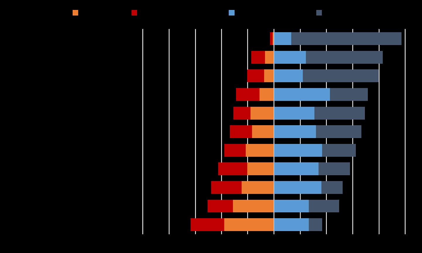
Respondents also had an opportunity to provide an explanation for their ratings in a written response question. The results of this question are shown in Figure 4.1.1. Respondents were overwhelmingly satisfied with Fire Services and tended to be generally satisfied with Trash Pickup and Law Enforcement. Respondents were most dissatisfied with Economic Development and Opportunities and Housing Development and Opportunities.
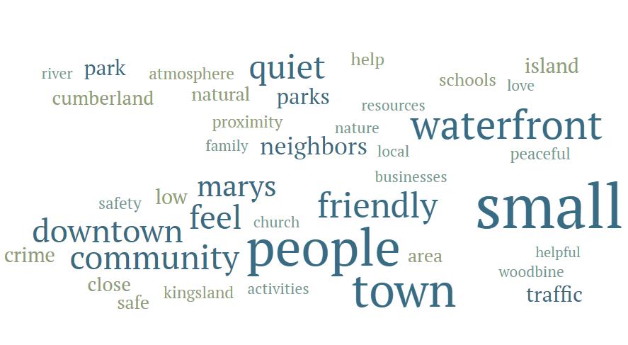
When asked what they like best in their community, references to small town feel, the people who make up their communities, downtown activities, and natural resources were the most common answer. Figure 4.1.2 shows a word cloud of the responses, with larger words being mentioned at a higher frequency.
Respondents were also asked what challenges their community had to overcome. These answers were more varied, but growth, poor drainage, local government transparency, and lack of things to do and places to eat were among the most frequent responses. For a breakdown of all survey questions, refer to Appendix C.
The priority needs and opportunities are informed by the SWOT analysis, identifying themes, overlaps, and similarities between topics. The needs and opportunities are then used to decide policies to pursue in the Community Work Plan. In the following tables, items that the community needs are on the left, and items that could bring new opportunities are on the right. Work items for each category can be found in the Short-Term Work Plan.
The future land use map is a visual guide to future planning. Future land use designations indicate the general development intensity for an area. The land uses identified are based on the Camden County development code, with additions where necessary. The future land use maps can be found in Appendix A.
Rural – This category is for areas featuring vacant lands that provide for the production of agricultural products and forestry pursuits. Residential development in these areas is limited to larger sized lots with the expectation that owners will provide their own water supply and sewage disposal facilities. The purpose of this area is to assist in the conservation of natural resources and provide opportunities for sustainable farming and timber harvesting operations.
Rural Residential – This category is for areas featuring low-density development reserved for a mixture of small farm and residential uses. The purpose of this area is to provide for an orderly transitionary space from agricultural to urban areas and to suppress urban sprawl while protecting the natural amenities of the area.
Residential – This category is for areas featuring low-density development reserved for a mixture of small farm and residential uses. The purpose of this area is to provide for an orderly transitionary space from agricultural to urban areas and to suppress urban sprawl while protecting the natural amenities of the area.
Multifamily – This category is for areas featuring a diverse array of residential districts in which dwellings containing two or more units are allowed. The purpose of this area is to provide a higher-density option for residential development while encouraging a stable and healthy living environment protected from encroachment of uses that would be detrimental to its character.
Mixed Use – This category is applied at the discretion of the community and features areas in planned development with land being considered for a variety of uses. The purpose of this area is to allow communities and developers the flexibility to decide the highest quality use case(s) for the area without the burden of strict zoning requirements.
Commercial – This category is for areas featuring business- uses including retail sales, office, service, and entertainment facilities. These businesses could be located in a single use building or grouped together in a shopping center or office building. The purpose of this category is to provide non-industrial businesses with the ability to serve customers and operate a wide range of sales and service facilities.
Industrial – This category is reserved for areas featuring manufacturing facilities, processing plants, warehousing and wholesale trade facilities, mining and mineral extraction activities, and other industrial uses. The purpose of this area is to provide industrial facilities with sufficient open areas and access to infrastructure necessary for healthy operations.
Public/Institutional - This category is for areas featuring public and semi-public uses. The purpose of this area is to provide certain governmental and institutional entities with the ability to conduct official business that serves the public.
Little Cumberland Island (Camden Only) – This category is for the area consisting of the entirety of Little Cumberland Island to preserve its unique ecological features.
Parks, Recreation, and Conservation – This category is for areas established to preserve and control development of certain land, marsh, and water areas. The purpose of this area is to protect the historical and ecological significance of Coastal Georgia to provide current and future residents the opportunity to enjoy its unique recreational and environmental benefits.
Manufactured Housing (Kingsland Only) – This category is for areas designed to meet the needs of mobile home residents either on individual lots or as a part of a larger “Mobile Home Park”. The purpose of this area is to provide a sound and healthy environment to protect mobile home residential areas from encroachment by incompatible uses.
Housing demand is driven by the economic and demographic conditions of the community. Number of households, household size, and home types are influenced by the market demand created by the culture of the community, job opportunities, and income. Camden County and its cities are seeing significant population growth that calls for housing that serves each member of its population.
This section provides tables and figures to illustrate the current housing conditions in Camden County as a whole. Combined with stakeholder input, these conditions lead to housing being addressed as a priority area in the community work program
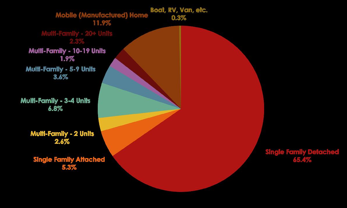
Between 2010 and 2020, Camden County has seen an 8.2 percent increase in housing units, with the City of Kingsland and City of St. Marys contributing over half of all housing stock. According to the American Community Survey 5-Year Estimates, 70.7 percent of housing units in the County are single family, with 65.4 percent of housing units being single family detached. Since 2020, the housing stock made up of multifamily housing units has been increasing.
During steering and stakeholder committee meetings, as well as in the community survey, opinions on housing types were varied. Many agreed that housing options would need to be more diverse in order to accommodate the population growth.
However, there was less support for large-scale multifamily complexes, particularly over 20 units. Community members in the cities advocated for less traditional housing alternatives like accessory dwelling units, live/work units, and main street residential/commercial units.
There are over 22,000 housing units in Camden, with 11.5 percent unoccupied. Of the housing units, 1.7 percent are non-primary residences.
Source: U.S. Census Bureau, 2006-2020 American Community Survey 5-Year Estimates
Since 2010, housing values in Camden have nearly doubled, with 2010 typical cost at $133,014 and 2023 numbers at $260,398, according to the Zillow Home Value Index and as shown in Figure 6.2.1. Homes in St. Marys tend to have the highest average value, but Kingsland has higher typical rent prices, shown in Table 6.2.1.

Source: Zillow Housing Research Data, January 31st, 2023, Zillow Home Value Index/Zillow Observed Rent Index
Cost-burdened housing is identified as households spending more than 30 percent of their income on housing costs and utilities. Severely cost-burdened households spend greater than 50 percent of their income on housing costs and utilities. In Camden as a whole, 15.3 percent of households are cost burdened, and 12.0 percent are severely cost burdened. The housing cost burden is higher in Kingsland and St. Marys and 4.7 to 12.0 percent greater for households that rent.
Source: U.S. Census Bureau, 2016-2020 American Community Survey 5-Year Estimates
Source: U.S. Census Bureau, 2016-2020 American Community Survey 5-Year Estimates
JJob to housing balance is a measure used by planners and government officials to guide development. It indicates whether there is enough housing for employees and sufficient jobs in residential areas. A balanced community generally has a jobs-housing ratio of 1.25 to 1.75. From 2016 to 2020 Camden had a jobs-housing ration of 0.90, down from 1.2 for the 2010-2016 period.
Source: U.S. Census Bureau, 2016-2020 American Community Survey 5-Year Estimates; U.S. Bureau of Labor Statistics, 2020 Local Area Unemployment Statistics
7. Transportation Roads and Highways
Railroads, Trucking, Port Facilities, and Airports
Alternative Modes of Transportation
St. Marys Transportation
Transportation priorities and policies identified within the comprehensive plan have a direct impact on all elements of the plan and are significant in shaping the County and its cities. Commercial and industrial developments are more likely to settle along major highways and interstates to provide easy access and lower transportation costs. Alternative forms of transportation, particularly biking and walking, are attractive to residential developments.
Interstate 95 (I-95) is the main highway that runs through Camden County and is classified as a Rural and Urban Interstate Principal route. I-95 is a six-lane interstate facility and serves as the primary north-south corridor in the region. I-95 connects Camden to Florida, as well as the northern counties in the region. I-95 is the most heavily traveled road in the county and is essential for transportation needs as well as commercial and industrial development.
US-17 is an essential minor arterial route in Camden. It is a two-lane route that provides access to the northern counties of the region up to Chatham County. US-17 is often used as an alternative north-south route for local travel to avoid traffic on I-95. US-17 also provides a scenic route through Camden and is essential for hurricane evacuations.
Railroad freight operations are active in the southeastern portion of Camden County. CSX Transportation connects in Jacksonville and maintains the line along US-17 from Florida north to Kingsland. Rail traffic into the County comes from Florida, as tracks north of Kingsland are out of service.
St. Marys Railroad operates a spur from the CSX line in Kingsland into central St. Marys and the NSB Kings Bay. The St. Marys line splits just east of the SR 40/St. Marys Road intersection. The harbor in the County is located at the former Gilman Paper Mill site. Nearly 50 acres of the former Gilman Paper mill site is planned to be converted into a boat manufacturing plant and marina near the corner of Osborne and Meeting Street.
Camden County no longer has a public airport but is interested in investigating the feasibility of one in the future.
When considering alternate modes of transportation in Camden County, it is important to recognize that while commuting by car is the most popular form of transportation at over 90 percent, the 2020 American Community Survey 5-year estimates indicate that 643 Camden households (2.7 percent) do not have access to a vehicle and 5,055 (21.5 percent) have access to only one vehicle. Furthermore, rising housing costs have forced workers to live further away from economic centers, increasing the cost of transportation. Meeting the transportation needs of residents for Camden County means providing viable affordable alternatives for commuters.
Camden County and its municipalities are continuing to work on developing a series of interconnected multi-use paths that afford residents and tourists the opportunity to safely explore, exercise, and commute throughout the County, without the need for a vehicle. These paths consist of eight to ten-foot maintained paths featuring some form of horizontal (e.g. curbs, landscape buffers) or vertical (e.g. bollards, trees) separation from existing vehicle traffic so as to accommodate people on foot, in wheelchairs, on bicycles, or in any other form of non-motorized vehicle. Such paths already exist along the SR-40 Spur and Point Peter Rd in St. Marys, along the Laurel Island Parkway in Kingsland, and in the communities of Woodbine and White Oak as part of the Georgia Coast Rail Trail utilizing repurposed rail infrastructure now that rail traffic in the county terminates north of Kingsland. Further development of multi-use paths is anticipated along developing corridors such as Colerain Rd and Winding Rd.
Two long distance, designated, non-motorized routes currently transit Camden County: US Bike Route 1 (USBR 1) and the East Coast Greenway (ECG). These are both interstate routes stretching from Florida to Maine along the eastern seaboard of the United States with the primary purpose to connect communities and provide non-motorists the ability to safely traverse this populated corridor. USBR 1 currently follows US-17 from the Florida border in the south to the border with Glynn County in the north. The East Coast Greenway design requirements call for a series of trafficseparated, multi-use paved trails of at least 8 feet. While the current route largely follows US-17, an envisioned route would begin at the St. Marys waterfront and utilize many of the existing and proposed multi-use paths within the County to provide users of the route a low-stress environment in which to travel.
Public transit in Camden County is currently provided by the Coastal Regional Commission of Georgia’s Transportation Department which operates a series of demand-response, advance registration coaches for residents in the region to use. Fares vary depending on the itinerary and service is available to all residents for any purpose. In previous plans as well as during the stakeholder meetings for this plan, interest was raised in providing more enhanced transportation services for residents, particularly workforce residents that would otherwise not be able to afford to live and work in Camden County. A pilot program operated by the Coastal Regional Commission for the City of St. Marys ran a semi-regular bus service in early 2018 but was discontinued due to low ridership. Future planning around providing some form of regular service public transit system within Camden County would come as the result of a multi-jurisdictional long range transportation plan with cooperation from its municipalities.
This section will seek to address the current and future development of transportation infrastructure and its use within St. Marys and the surrounding areas.
St. Marys’ transportation network is developed around three unique geographic aspects. St. Marys is influenced by the natural environment. The city sits on a small, low-lying peninsula jutting out between the St. Marys and Crooked Rivers with significant portions of its land being undevelopable salt marsh. SR 40 acts as the principal arterial for residents and visitors alike, going east from Exit 3 off I-95 through midtown and becoming Osborne Street before terminating by the waterfront downtown. Many of the smaller arterials and collector roads within the city link into SR 40. Almost all residents will use this road to get to or from downtown and many will use it as part of their commute every day.
Secondly, St. Marys is influenced by its neighbors, Kingsland and NSB Kings Bay. The City shares its peninsula most directly with NSB Kings Bay, by far the largest employer in the county and base of operations for the Atlantic-based Ohio-class submarines. The only currently open entrance to the base can be found on its west side near the intersection of Kings Bay Rd and SR 40 spur, the two roads most traveled by those employed by the base. St. Marys’ closest other neighbor is that of the municipality Kingsland. The two cities share many similarities from their similar size of around 18,000 residents to the roadways they rely on like SR 40, Laurel Island Pkwy, and I-95. Both are home to many of those people and families employed by NSB Kings Bay. As such, the transportation networks of the two cities are incredibly intertwined.
Lastly, St. Marys is influenced by its access points. The City receives its most direct access to the outside world via I-95 at Exit 1 and indirectly through Kingsland at Exits 3 and 6. From this, the larger metropolitan areas of Jacksonville and Brunswick are only 40 minutes away by car. In addition to automobile access, the City contains several water access points as well. There are currently three public boat ramps used by residents and visitors alike. One by the waterfront downtown, another nearby off Meeting St, and the final one on the very northernmost extreme of the city by Crooked River State Park feeding into the Crooked River itself. The City maintains a small marina on the waterfront in the St. Marys River for travelers to dock at which also serves as the staging ground for the ferry service to Cumberland Island National Seashore located approximately 5 miles east of the City. The City itself is only a couple of miles upstream from the Cumberland Sound and the Atlantic Intracoastal Waterway, a series of interconnected inland waterways serving the Eastern Seaboard of the United States by providing boaters a relatively safe, unobstructed route to traverse up and down the coast without having to enter the open Atlantic Ocean.
In addition to the motorized transportation system, St. Marys has a developing system of infrastructure built specifically with non-motorized transit in mind. The downtown waterfront is home to a wide multi-use path allowing residents and tourists, such as those waiting for the ferry to visit Cumberland Island National Seashore, the opportunity to park their cars and walk to restaurants and shops nearby. Downtown is connected with a rather robust series of sidewalk paths in and around St. Marys Elementary School. The rest of the community is home to several multiuse paths off Point Peter Rd and SR 40 Spur. Just outside city limits is the multi-use path along the Laurel Island Pkwy traveling west through Kingsland. There is also Crooked River State Park at the northern end of the community featuring several popular walking trails.
The East Coast Greenway also runs through the area. Currently the existing route bypasses St. Marys and instead follows US-17 through Kingsland, however, an envisioned route put forward by the ECG organization would utilize a hypothetical semi-regular ferry service from Fernandina Beach, Florida to St. Marys. This would have the route starting in Georgia from the St. Marys waterfront along St. Marys and Dilworth Streets, up the existing multi-use path on Point Peter Rd to Commerce Park. The path would then take the multi-use path on the SR 40 Spur to Winding Rd before finally meeting up with the Laurel Island Pkwy to continue on towards US-17.
The biggest need for the community with regards to non-motorized transit would be to address the lack of any pedestrian infrastructure along Kings Bay Rd, particularly by the hospital. Attention should also be paid to connecting Sugarmill Elementary School to the northern marsh side communities it serves to allow students to safely travel to school on foot. There are a number of crossings on Winding Road as the school currently sits on the south side of the road while most of the residential developments can be found on the north side. In addition to these specific examples, newly developing communities in and around midtown and Commerce Park should be provided with safe and accessible bicycle and pedestrian infrastructure that connects with the existing nonmotorized transit network of St. Marys. The community can also look to adopt “Complete Streets” policies guiding urban development with a focus on accommodating all types of motorized and non-motorized transit to aid in these developments.
To accommodate the envisioned route of the ECG through the community, additional 8-to-10foot multi-use paths are needed along Winding Rd, Douglas Dr, Dilworth St, and St. Marys St W. Furthermore, additional planning work will need to be accomplished by the City to establish a ferry service between St. Marys and Fernandina Beach and the type of private/public partnership and support necessary to make the route feasible.
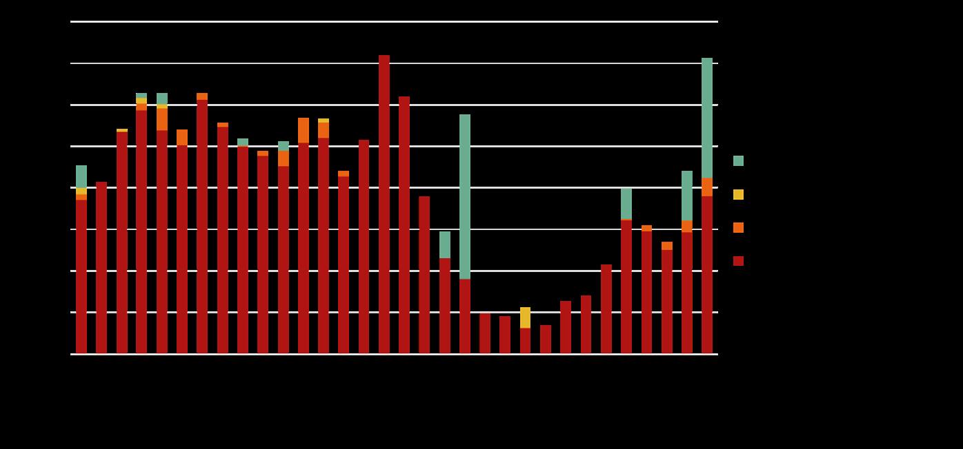
Traffic statistics are measured using the Annualized Average Daily Traffic (AADT) figures released by the Georgia Department of Transportation every year. As of 2021 Interstate 95 is the most traveled road in the St. Marys area with 60,000 to 70,000 vehicles passing daily. The next most trafficked roads are predictably the arterial and collector roads already mentioned, SR-40, St. Marys Rd, and Kings Bay Rd.
Truck traffic is mostly limited to the major arterials and only comprise more than 5 percent of the AADT on I-95 as well as parts of St. Marys Rd, the SR-40 Spur by NSB Kings Bay entrance, and the North River Causeway connecting Point Peter to the rest of St. Marys. By comparison, truck traffic is relatively low in the residential areas of downtown, Colerain Rd, and Winding Rd.
Table 7.4.3.1 showcases the traffic volume numbers observed on the busiest roads as of 2021 and compares them to the projected 2041 traffic numbers. For roads with multiple measurements from different parts along the road, the highest trafficked section was used.
Over the next 20 years, it is expected that I-95 will remain the most trafficked road in the area with a projected AADT of 124,000, an increase of 76%. SR-40, Colerain Rd, Point Peter Rd, and Winding Rd are all expected to increase their average daily volume of vehicles by over 40 percent as well. This broadly falls in line with expected residential development patterns in the future. Large tracts of Point Peter as well as the areas surrounding Colerain and Winding Rd are currently zoned for “Planned Development”.
The biggest needs for St. Marys relating to traffic is continuing to monitor changing commuting patterns as development takes place in and around Commerce Park and midtown. Currently SR-40 is the only major road connecting downtown and Commerce Park to the rest of the community and while today’s traffic demand is easily met, improvements to Douglas Dr and its intersection with SR-40 Spur could help alleviate any future concerns and provide residents of Point Peter an alternate route into midtown.
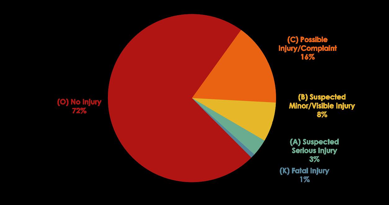
According to the Georgia Electronic Accident Reporting System and Numetric, between 2013 and 2021, St. Marys recorded 1,005 vehicle collisions. Of these, 277 (27.6 percent) resulted in a potential injury including eight that were fatal.
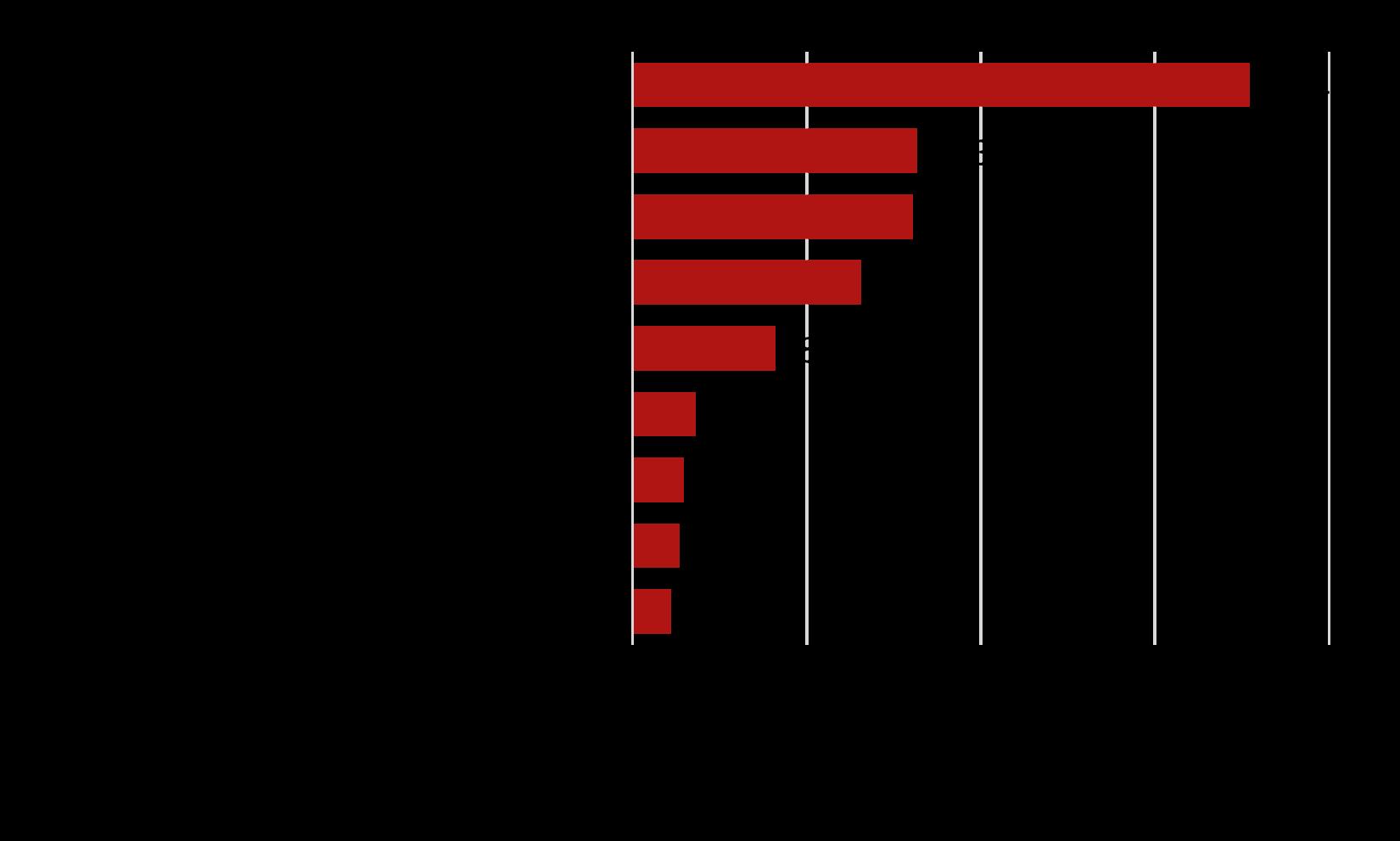
Over half (577) of reported collisions were considered “Intersection-related” meaning they took place at or near the intersection of two public roads. The intersections with the highest occurrence of collisions are as follows:
7.1 SR-40 and SR-40 Spur – 66 collisions
7.2 St. Marys Rd and SR-40 – 62 collisions
7.3 St. Marys Rd and Colerain Rd – 46 collisions
7.4 Kings Bay Rd and Colerain Rd – 45 collisions
7.5 Kings Bay Rd and Lake Shore Dr – 41 collisions
These five intersection sites represent approximately a quarter of all collisions within St. Marys from 2013 to 2021.
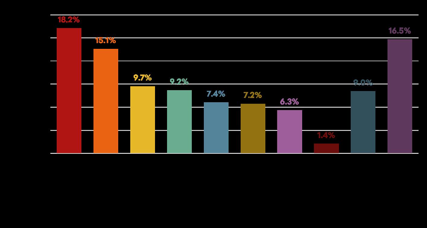
Broken down by types of collisions, the most common collision type was a “rear end” with just over one in three incidents being classified as such. Incidents involving only one vehicle such as when the motorist loses control of the vehicle, accounted for one in six incidents as did “Angle (Other)” most commonly called a “T-bone”. The remaining third of collisions were made up of side sweeps, right angle crashes, left angle crashes, and head on collisions.
The vast majority (93 percent) of St. Marys non-military residents commute to work by car, either by themselves (83 percent) or as a part of a carpool (10 percent) according to the U.S. Census Bureau’s American Community Survey 2020 5-year Estimates. Five percent are estimated to work from home and so the share of St. Marys residents commuting to work via other non-motorized means is less than two percent.
Source: U.S. Census Bureau, 2016-2020 American Community Survey 5-Year Estimates
Approximately 191 (2.5 percent) of commuting households do not have access to any vehicles to get to work and another 1,982 (25.6 percent) are single vehicle households.
Source: U.S. Census Bureau, 2016-2020 American Community Survey 5-Year Estimates
St. Marys does not currently have a public transit system for its citizens to use. In place of this, the Coastal Regional Commission operates its coach services in the area. These trips are point to point and are required to be scheduled in advance on a first come, first serve basis.
The Census Bureau estimates that roughly half of commuters from St. Marys take, on average, between 10 to 20 minutes to reach their place of work and the mean travel time as of 2020 is 20.4 minutes.
The Census Bureau’s 2019 Longitudinal Origin-Destination Employment Statistics reports that the vast majority of non-military St. Marys workers do not live within the City limits. Instead, roughly three out of four commute from elsewhere in the region with the largest sources being Kingsland, the rest of Camden County, and Glynn County.
Roughly four out of five residents of St. Marys that do work, do so outside the city limits. The largest receivers of St. Marys talent being Kingsland, the rest of Camden County, and Glynn County.
Economic development creates the conditions for economic growth and improved quality of life by expanding capacity of individuals, firms, and communities to maximize the use of their talents and skills to support innovation, and responsibly produce and trade valuable goods and services. Resilient economic development requires effective, collaborative institutions focused on an economic environment that is able to anticipate, respond, and rebuild after an economic shock.
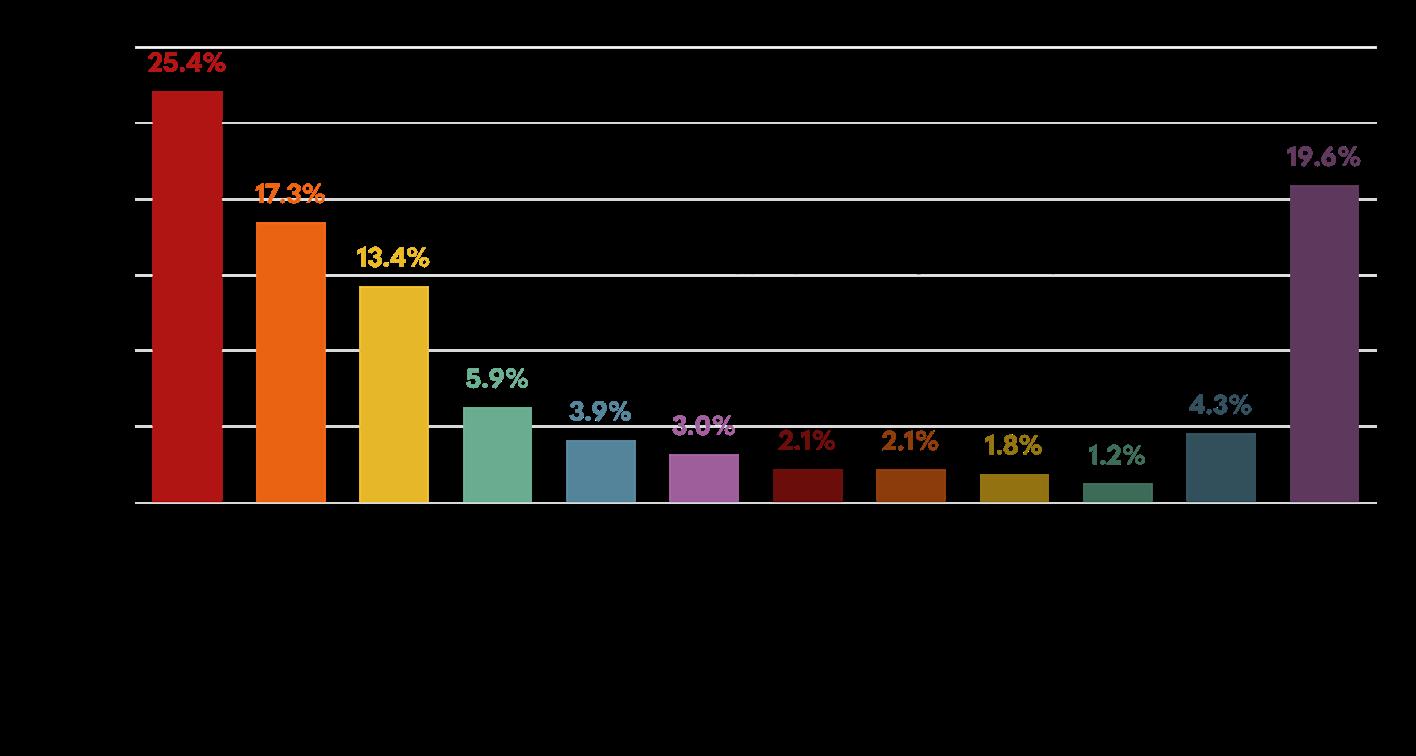
Figure 8.1.1 provides the percentages of Camden County workforce employment by industry. Over a third of the County is employed in the federal government industry, both military and non-military. Trade, transportation, utilities, and education and health services make up the next largest industries for Camden.
Source: U.S. Census Bureau, 2006-2020 American Community Survey 5-Year Estimates
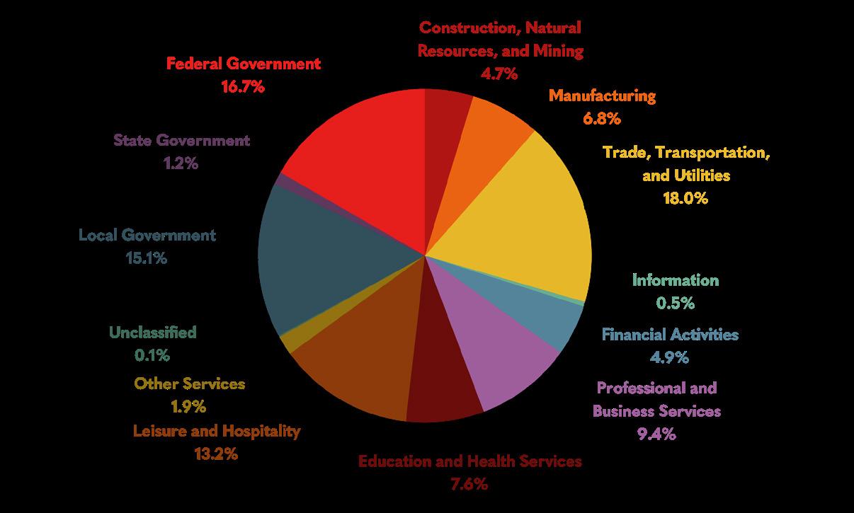
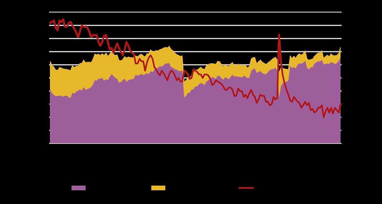
Table 8.1.2 shows the Camden County labor force classes. In 2020, 61.5 percent of workers were classified as private wage and salary workers, a 2.7 percent increase from 2015. Government workers made up 24.8 percent of workers, a 3.6 percent increase from 2015.
Source: U.S. Census Bureau, 2006-2020 American Community Survey 5-Year Estimates
Unemployment in Camden County has been steadily declining in the last decade, except for early 2020 during the global pandemic. As of January 2023, the unemployment rate in Camden is three percent.
Source: U.S. Census Bureau, 2019 LEHD Origin-Destination Employment Statistics
Access to broadband internet is one of the most crucial elements for a community looking to grow their economy, develop their workforce, and improve the overall quality of life for residents. Interest has already been shown in attracting new types of high-tech and advanced industries to the area by taking advantage of the relatively young and educated workforce. These types of industries and the workers they employ have come to expect fast, reliable internet service and will seek out areas that can provide it. Camden County and its municipalities can investigate the need for a broadband model ordinance to address any potential inadequacies in their current broadband network and apply to be designated as a Broadband Ready Community. A map of the broadband services can be found in Appendix A.
In 2018, Georgia launched the Georgia Broadband Deployment Initiative with the intent to promote the deployment of broadband services in areas considered “unserved”, meaning those areas not meeting the minimum required internet speeds of 25 Mbps download and 3 Mbps upload. According to the June 2022 Georgia Department of Community Affairs Broadband Availability Map, the cities of Kingsland and St. Marys have broadband coverage at over 99 percent of locations served. The unincorporated areas of Camden County have a lower rate of coverage with 78.8 percent of locations served. Most of the unserved areas in Camden County can be found in land designated as “Rural” or “Rural Residential” on the future land use map located on the western and northern parts of the County. Some of these locations, such as Cumberland Island National Seashore, have substantial logistical challenges to accessing broadband.
amden County has celebrated natural areas and sensitive ecosystems that provide a unique landscape for residents and visitors. During the public engagement process, natural areas and resources were often mentioned as an aspect of Camden County that gave residents a sense of place and pride in their communities. Stakeholders expressed concern over the preservation and protection of the sensitive areas that give Camden its unique character.
Resilience is the capacity of any system to withstand threats and recover from those threats efficiently and effectively. Resilience can pertain to nearly any field or discipline. Community resilience is reliant on all aspects of the community and measured by how well community systems respond to adverse events. Economic diversification, equity and social justice, public health, and income equity all impact the overall resilience of Camden County. For a more holistic approach, these aspects of resilience are included throughout plan elements and the Short-Term Work Plan (STWP). Maps for coastal resilience can be found in Appendix A.
Coastal communities, like Camden County, are particularly vulnerable to the changing environmental landscape brought on by threats like climate change, urban development, and natural disasters. Storm surge, sea level rise, and tidal inundation create challenges for residents. Community education on these threats is important and affects where residents choose to live, what they build, and how they protect their property. Planning for coastal hazards, both on the part of local governments and residents, increases safety, reduces property loss, protects historic and natural character, and lessens the disruption to economic development.
Camden County is located in the Lower Coastal Plain region of Georgia. Its highest point is 98 feet above sea level and has an average elevation of 13 feet. Camden is also home to several waterbodies, including Crooked River, Cumberland River, and St. Marys River. Cumberland Island is a barrier island off Camden’s coastline. It is home to Cumberland Island National Seashore, a major cultural and natural asset for the County.
Sea level rise is expected to have a significant impact on Camden County. Sea level rise stresses both natural and human systems by increasing vulnerability and decreasing the ability of the systems to combat disruptions and recover. Impacts of sea level rise are expected to be shoreline erosion, storm and flood damages, increased flood frequency, changes to the distribution of wetlands, and saltwater intrusion into habitats and groundwater. The USACE has run models to predict sea level rise along the coast with three estimates of future rise. Camden County’s closest National Ocean Service gauge is in Fernandina Beach, Florida. Data collected at the Fernandina Beach gauge suggests an estimated 0.39 foot increase for the USACE low scenario, 1.84 feet for the USACE intermediate scenario, and 6.46 feet for the USACE high scenario, all by 2120.
Sea level rise threatens infrastructure and property throughout the County. Identifying at-
risk areas and understanding the severity of potential impacts improves the minimization of consequences. Assessments for sea level rise impacts for development projects can be a useful tool for building a more resilient Camden County. Preventative measures including updated building codes will be a more cost-effective approach than response efforts to damages.
Camden County is a part of the Community Rating System, an incentive program that encourages floodplain management practices beyond the minimum requirements set by the National Flood Insurance Program. Insurance rates are discounted to reflect reduced flood risk. Discussions with residents revealed that flooding and drainage are big concerns across the County. Residents showed interest in proposing ordinances that would mitigate flooding issues.
Certain populations are hit the hardest by disruptions. Vulnerable populations require extra planning on behalf of local government agencies to ensure the safety of all residents during disaster events.
Vulnerable populations include young children, the elderly, those facing poverty, and those without reliable means of transportation. Table 10.2.1 shows the vulnerable populations, based on age, for Camden County, Kingsland, and St. Marys. The over age 65 group continues to grow across Camden County. Adults over the age of 65 are more likely to encounter aging related diseases or more advanced chronic conditions that can impede their mobility and access to care.
Table 10.2.2 shows that the percentage of households in Camden without access to a vehicle increased from 2015 to 2020, with the most significant change seen in St. Marys, with a 1.9 percent increase. Transportation access can affect all aspects of life, particularly access to employment and educational opportunities. This is exacerbated further by a lack of pedestrian infrastructure in parts of Camden County and the cities, which has been identified as a priority need. Households without access to a vehicle are especially vulnerable during disturbance events like hurricanes, which may require evacuation, and become dependent on other sources for transportation, like government organizations or neighbors.
Source: U.S. Census Bureau, 2011-2020 American Community Survey 5-Year Estimates
Table 10.2.3 shows the income and poverty statistics for Camden, Kingsland, and St. Marys for 2015 and 2020. The poverty rate has risen in all three, with Kingsland seeing a decrease in median income. Residents experiencing poverty are more exposed to environmental risk factors and are less able to invest in risk-reducing actions. Locations with increased risk like flooding tend to offer more affordable housing.
Source: U.S. Census Bureau, 2011-2020 American Community Survey 5-Year Estimates
The Economic Development Administration defines economic resilience as “the ability of a region or community to anticipate, withstand, and bounce back from shocks and disruptions, which includes both natural and human disasters”. Communities with unequal distribution of wealth are less resilient to economic shock, making recovery efforts more difficult. The Gini Index is a tool that calculates the level of income inequality a community faces based on the difference between the observed cumulative income distribution and the ideal equal income distribution. A coefficient of zero is considered perfect equality and one is considered extreme inequality. A higher Gini coefficient indicates a smaller amount of people hold a higher proportion of wealth. Since 2015, the Gini coefficients for the County, Kingsland, and St. Marys have all increased creating larger separations in wealth as shown in Table 10.2.4 below.
Source: U.S. Census Bureau, 2011-2020 American Community Survey 5-Year Estimates
The community work plan is a collection of action items to aid in addressing the needs and opportunities found earlier in the plan. These items include policies, ongoing efforts, short and long-term efforts, funding identification, and opportunities for collaboration.
The Report of Accomplishments is an update of the 2018 Comprehensive Plan’s work program, identifying the status of each action item.
infrastructure
Coordinate with and support local development organizations, such as the Chamber, Joint Development Authority, etc.
Inventory and promote natural, historic, cultural and recreational resources that will promote Camden County as a tourist destination.
Adopt and implement community appearance ordinaces - for landscaping, litter and design control, corridor management, and the cleanup of dilapidated properties, etc.
Refer to Housing Inventory of Unincorporated Camden County (2005) to encourage affordable housing.
Strategic Planning
control aspect was not well received by community. Stricter litter and beautification efforts have been added to the current work plan.
A new housing study was done more recently, and the efforts to promote affordable housing are ongoing.
Explore potential developers to coordinate with to build affordable housing. 2018-2022
Encourage reduction of the number of mobile homes by making affordable housing an option.
Explore programs available for affordable housing.
2018-2022
Adopt Georgia Historic Preservation Division's model ordinance requiring the protection of locally designated hsitoric properties and districts.
2018-2022
Strategic Planning
n/a
Adopt Georgia Historic Preservation Division's model design standards for infill and material changes to historic properties or districts to maintain historic integrity and significance.
Adopt corridor overlay districts for prominent roads in the County require the preservation of existing trees in ladnscaped buffers.
n/a
Development, Strategic Planning
n/a Planning and Development, Strategic Planning Staff Time General Fund Not Accomplished
Staff
Time
No historic properties were found to be applicable for a model ordinance.
Require or provide incentives for new development to conserve and protect open space and greenspace within subdivisions
Staff
Time
Variable
Property owner's participation, grants
Variable General
Fund Ongoing
and research possible funding
Build new ditches to facillitate increased stormwater management.
Continue strategic planning for water and sewer needs
Construct roads with consideration to fire, police, and other emergency services for future developments
Purchase paver and add staff to Public Works Department accordingly n/a
Pave un-paved roads
Increase staff capactiy for Road Department to meet needs beyong maintenance.
Continue coordinated emergency planning efforts with Naval
Coordinate with Chamber and other entities as the County becomes a Metropolitan Statistical Area; will need to create a Metropolitan Planning Organization
Coordinate infrastructure and communication improvements with surrounding countiesBrantley, Charlton, Glynn, Wayne, etc. - as need or desired
Intergovernmental Coordination
Not Accomplished Has been more cost efficient to lease paver and contract out staff.
Work in conjunction with neighboring jurisdictions to implement the Joint Comprehensive Plan
coordinating with City of Kingsland on Fire Services Agreement
Public Safety Communications Plan (public works, school board, sheriff, police, fire, EMS) with Cities
Fire Rescue
emergency planning services with the Citiies
Development Patterns
Draft a small area/corridor plan for the area west of I-95 along Highway 40 toward downtown
Adapt Zoning Ordinance to current opportunities/issues
Encourage development in line with best practices
Economic Development Support the Downtown Development Association's Program and Activities
Draft Economic Development implementation plan that includes a strategy that supports Space Port Camden
Coordinate with and support other local development organizations sucha s the JDA, Camden Partnerships, and St. Marys
Work with Gateway CID to develop
3 attraction
Draft a small area revitalization plan for
Boulevard
Draft a small area revitalization plan for North and South Orange Avenue
Create a county-wide land bank and inventory property to identify sites appropriate for redevelopment
Continue the practice of encouraging developers to provide for open space in their developments that links together into a publicly accessible open space netowork in the PD zones.
Apply for the National and State Register of Historic Places designation for buildings of historic significance.
Adopt corridor overlay districts for prominent roads in the City; require the preservation of existing specimen trees in landscaped buffers.
Evaluate results of historic preservation programs
Continue to support the annual
Festival
Update capital improvement projects listed in Short Term work Program
Work in conjunction with neighborhing jurisidictions to implement the Joint Comprehensive Plan
Continue mutual aid agreements (fire, police, building inspection, code enforcement, etc.)
Update Comprehensive Plan in 2022, or sooner if major changes occur or new trends develop in conjuction with other jurisdictions.
Implement Rails to Trails recommendations, such as a multi-use path
Codify the recommendations from the JLUS study through creation of an overlay district within 3,000 feet of the Subbase.
Implement the findings of the Joint Land Use Study (JLUS)
Create with the County a land bank according to State legislation.
Develop design standards for Midtown Renaissance commercial corridor and incorporate in zoning code.
Incentivize infill residential development and allow for mixed use in downtown St. Marys.
Create form based zoning in downtown St. Marys.
2022
2022
Add specific family friendly entertainment uses to appropriate zoning classifications.
Ensure that development on the previous Mill Site and at the airport are coordinated with the SUBASE leadership.
Perform a market study for the St. Marys Airport property to determine the highest and best use and to establish appropriate zoning.
Review and update the City’s codes and development standards to ensure that future development does not adversely impact the environment.
2022
2022
2022
2021
Incentivize the reuse or redevelopment of existing commercial/industrial buildings over the development of new properties, where appropriate.
Work with public and private entities to develop the aquaculture industry in St. Marys including identifying harvesting locations and support facilities including the Weed Street location.
Work with the owner(s) of the Kings Bay Village to update and redevelop the site.
Study feasibility of SUBASE fence line relocation to address Cumberland Harbor tower.
Create upper-story housing incentives in downtown.
Utilize innovative planning, zoning and funding solutions to provide affordable, quality housing for eligible civilian and military households.
Support Georgia Initiative for Community Housing program by providing board member(s) to increase opportunities to implement housing initiatives and further affordable housing development.
Expand current drainage system maintenance program. 20202021
Support initiatives and projects that promote mixed age communities via a special use for independent living elderly facilities in the R1 zone.
2022
Update Water, Sewer, and Stormwater Master plans. These plans should consider the built- out conditions that would potentially result from the proposed zoning ordinance updates.
Determine the feasibility of recruiting one or more grocery stores to under-served areas
Develop a plan to annex islands of unincorporated Camden County that currently receive City services at little to no cost.
Encourage and support development of continuing care communities.
Implement planned downtown improvements in accordance with the CIP.
Update design standards and development ordinances to address community interconnectivity as development occurs.
Review and revise the existing permit and license fee structure, including alcohol licensing, to support new and existing restaurants.
Implement a blight tax on properties to encourage compliance with property maintenance standards.
Adopt a formal landscaping ordinance to improve the aesthetics and stormwater design of new development and redevelopment.
Create a plan to revitalize mid-town. This plan should include events and activities in this area to increase activity, create demand, and foster investment.
Work with Kingsland, Camden County, and State officials to support construction of the planned technical college in Kingsland.
Consider and budget for business incentives including tax abatement, reduced/waived fees, etc.
Develop partnerships to support historical tourism and related businesses.
Market opportunities to host conventions, sports activities, etc.
Support the “Keep It in Camden”and “EDIMADIC” campaigns
Investigate, encourage and support diversification in marina opportunities.
Design and implement the completion of St. Marys Street at the waterfront.
Identify what steps the City could take to recruit eco-tourism businesses to St. Marys.
Better utilize a revolving loan fund for economic development.
Update the Economic Diversification of Camden County Strategic Report and consider development of a new countywide Comprehensive Economic Development Strategy.
Develop a long-term plan for Orange Hall that will ensure its restoration and continued operation.
Acquire and permanently protect low-lying wetland areas as a flood storage areas.
2022
2022
Adopt the Coastal Stormwater Supplement to reduce flooding and ensure that stormwater runoff does not cause pollution of the coastal marshlands.
Develop partnerships that enhance St. Marys heritage such as oral histories, pictures, etc. and find innovative ways to exhibit those projects to residents and visitors.
20202021 CD Unknown General Fund
2022 Volunteers, CVB
Implement the Stormwater Master Plan. 20182022 City Unknown General Fund, GEFA
As determined feasible and upon the request of property owners, submit nomination to expand National Register and local historic district.
Establish a National Historic Landmark site at the Point Peter, War of 1812 encampment.
Establish a Veteran’s memorial for all wars and all services at an appropriate location.
Support efforts to inventory Ft. Tammany and artifacts from the area.
Investigate and lmplement new Gateway welcome structures at the various entryways to the City.
Provide RV opportunities (storage and parks) as special use in defined areas.
Make public buildings, parks, and city facilities Wi-Fi enabled.
Explore the option for joint ventures for technologies (consolidated IT) with other cities and Camden County.
Work to maximize docking opportunities along the St. Marys Waterfront, including the Gateway Marina project.
20182022 City Unknown General Fund, Grants
20182022 City, NPS Unknown General Fund, Grants
20182022 City
20182022 NPS
20182022 City
20182022 CD
20182022 IT
20182022 CMO
20182019 DDA, CD & PW Unknown Grants
Update and modernize programming at the Senior Center to significantly increase the number of seniors served daily.
Streamline business licensing and permitting process.
Create a Parks & Recreational Services Master Plan with the PSA and regional partners based on a regional market assessment that takes into account SUBASE programming and interest to expand youth activities.
Consider the possibility of using city operated facilities and finding partners to house a supervised and structured community center for youth that can provide entertainment and life-skills training.
Identify funding for implementation of Tabby Trail. 2020-
Develop partnerships with regional health organizations to develop trail network.
Consider the use of LED lighting to improve visibility in downtown neighborhoods and promote long-term cost savings and energy efficiency.
Investigate a mobile farmers market program that utilizes a food truck to provide opportunities to purchase healthy foods in under served areas.
Update the City’s hardware and software for efficiency and security. 20182022
Expand the City's GIS capabilities and services.
Continue to annually prioritize the many suggestions of the RSVP and include the most appropriate and financially feasible suggestions in its annual work-plan.
2022
2022
Apply for WaterFirst designation so that the City will be more competitive for grants and eligible for a discount on Georgia Environmental Finance Agency (GEFA) loans interest rates.
Maximize benefits of the Community Rating System program to minimize impact of Federal Emergency Management Agency (FEMA) flood insurance rate increases on property owners by achieving a CRS rating of 5.
Continue to implement the JLUS recommendations.
Conduct a staffing needs assessment for all city departments.
Establish a Comprehensive Resource Allocation and Capital Improvement Plan (CIP) to implement a prioritized Master Plan incorporating specified activities in the Master Plan. Plan should include all resources; financial, staff, consultant, citizen appointee utilization, equipment/facility use, maintenance and replacement.
Develop and implement a transparent reporting apparatus and review process for St. Marys’ boards and committees, which provides City Council and management a functional oversight system for tracking and auditing City priorities, policies, programs and projects.
Work with Camden County, Kingsland, Woodbine, the JDA, and the Chamber of Commerce to effectively market the next SPLOST referendum.
Develop a prioritized CIP for making stormwater repairs recommended in the Resiliency Study and Stormwater Master Plan.
Hire such personnel as may be needed to inspect and enforce ordinances and regulations implementing the plan.
Perform an evaluation of all relevant ordinance (signs, landscaping, tree, etc.) and determine if updates are needed to support the goals and visions of this plan.
Consider adoption of a stormwater utility to fund needed stormwater improvements.
Coordinate with the National Park Service Foundation Statement for the future of the Park and Concessions at the park.
The Police Department should develop strategies to strengthen the community outreach program.
Install green infrastructure (GI)/low impact development (LID) practices to address stormwater runoff quantity and quality.
Continue coordinated emergency management response with SUBASE Kings Bay and Camden County.
Use NOAA sea level study findings in future required updates to the Camden County Joint Comprehensive Plan.
Consider instituting Accident and Incident Recovery Fees for emergency response services performed by the City's Fire Department.
20182019
20202021 CD
20202021
2021
20182022
20182022
20182022
20182022
20182022
20182019
Improve communications with citizens through regular and meaningful updates to the website and Facebook, increased use of online services and expanded use of GIS. Develop alternative methods of reaching citizens without technology access.
Develop specific golf cart regulations and education materials that allow for use on designated streets.
Participate in a county-wide resiliency plan that is consistent with the County Plan and National Incident Management
Support efforts of the local hospital and nonprofit agencies working to increase mental health services in Camden County.
Prioritize and install tide gates/flaps on stormwater outfalls below mean high tide
Implement the Gateway landscaping plan for St. Marys Road at Exit 1.
Review and update 2005 Camden County Bicycle and Pedestrian Study.
Expand the DDA facade grant program through matching funds.
Work with SUBASE Kings Bay and regional partners to cooperatively address additional traffic within the navigable channels.
Perform a financial assessment of the City’s water and sewer debt to determine if refinancing is a viable option.
Identify and map all known City rights of way and easements.
2019
2021
2022
2022
2022
Work with the Navy and local and State development authorities to enhance usage of the rail access as part of the Mill Site and airport property development while assuring that sufficient safety and traffic concerns are met.
Seek grants for trails and other features that provide low-impact access to the coastal environment.
Evaluate and implement a partnership of the City of St. Marys and SUBASE Kings Bay to initiate limited gate opening and operation.
Explore alternative funding sources and options with the County, the CRC, private transportation agencies (university, hospital, SUBASE, etc.), or private rideshare providers to provide alternative transportation in under- served areas.
Modify existing golf cart ordinance to meet the goals outlined in the Multi-Modal Transportation Plan.
Consider SR 40/Osborne Road improvements, including implementation of raised and landscaped median, improved bicycle and pedestrian facilities, wayfinding signage, and landscaping.
20182022 CMO
20182019 CD
20182019 CMO
20182019
Completed Coordination with NSB Kings Bay determined this action item to be infeasible.
Upgrade intersection of St. Marys Road and SR 40/Osborne Road to incorporate Gateway elements.
2021
20202021 CD Unknown General Fund/ SPLOST Ongoing
20202021
2020-
CD Unknown General Fund Ongoing
Adopt access management techniques (i.e. inter-parcel access roads, and corridor planning) to maintain Level of Service for limited access state routes (under SUBASE review), while providing property owners and City tax digest the highest and best use of property.
Explore options to correct the current connectivity issues in established areas including Brant Creek and Shadowlawn.
Implement a comprehensive wayfinding signage plan.
Upgrade crossings and access to Crooked River, Mary Lee Clark, and Sugar Mill Elementary Schools, as outlined in the MultiModal Transportation Study.
Consider local safety projects for submittal to GDOT for funding through the lump sum safety program.
Relocate Douglas Drive to directly connect to North River Causeway and create a new intersection of Douglas Drive at Point Peter Road.
Construct a multiuse path/marsh walk from St. Marys Street to the Aquatic Center through existing marsh.
Conduct a downtown parking study.
Explore reducing the speed limit on the North River Causeway. 20192022
Explore with GDOT reducing the speed limits on Spur 40, etc. 20192022
Participate in the exploration of creating Rails to Trails. 20192022
Work with GDOT to provide a multiuse path along Osborne Road with bridge widening at Dark Entry Creek.
Work with GDOT and GEMA to implement emergency evacuation routes as soon as possible.
20192022 City, GDOT Unknown General Fund, GDOT Ongoing
20192022 City, GDOT Unknown General Fund, GDOT, GEMA Ongoing
to pursue grants for stormwater and drainage improvements, like the Hazard Mitigation Grant through GEMA.
or provide incentives for new development to conserve and protect open space
greenspace within subdivisions
Industry Marketing Strategy to entice desirable industries to move to Camden County.
partnerships with educational institutions to develop apprenticeships, internships, STEM camps, and promote increased technology utilization in middle and high school classrooms.
Apply for Georgia Outdoor Stewardship Program Grant to further develop greenspaces and trails for recreational opportunities.
previously undisturbed marsh hammocks
Pursue state funding for income reflective attainable housing, such as CHIP and the Rural Workforce Housing Fund.
towards designated infill areas with existing infrastructure.
growing population clusters that are in need of expanded infrastructure.
areas and expand provision of public water to areas of the county that currently rely on wells.
Explore the need for a new fire station and possible locations.
Investigate the need for a Broadband Model Ordinance to reduce obstacles to broadband infrastructure investment
Increase County’s “Safe Route to Schools” partnership level and apply for “Safe Routes to School” funds.
Identify locations and funding opportunities that could support the installation of a multi-use path.
Enhance government social media outlets to inform communities about community services, community projects, and enhance public participation in government.
regular-scheduled joint meetings with city governments to address long-range needs.
with and support local development organizations, such as the Chamber, Joint Development Authority, etc.
facilities with neighboring jurisdications when mutually beneficial.
housing development towards designated infill areas with existing infrastructure.
Adopt zoning ordinances to allow for alternative forms of housing such as tiny homes, accessory dwelling units, live/work units, or main street residential/commercial units.
growing population clusters that are in need of expanded infrastructure.
locations and funding opportunities that could suport the installation of a multi-use path.
with CRC and GDOT on a transportation study to target high traffic areas.
Enhance government social media outlets to inform public on community services, community projects, and enhane public participation in government.
regular-scheduled joint meetings with city and county governments to address long-range needs.
opportunities to share services and facilities with neighboring jurisdications when mutually beneficial.
the County a land bank according to State legislation.
for Midtown Renaissance commercial corridor
and update the City’s codes and development standards to ensure that future development does not adversely impact the environment.
the reuse or redevelopment of existing commercial/ industrial buildings over the development of new properties, where appropriate.
Work with public and private entities to develop the aquaculture industry in St. Marys including identifying harvesting locations and support facilities including the Weed Street location.
with the owner(s) of the Kings Bay Village to update and redevelop the site.
expiration date requirement to new Planned Developments
Georgia Initiative for Community Housing program by providing board member(s) to increase opportunities to implement housing initiatives and further affordable housing development.
partnerships that enhance St. Marys heritage such as oral histories, pictures, etc. and find innovative ways to exhibit those projects to residents
As determined feasible and upon the request of property owners, submit nomination to expand National Register and local historic district.
Work to maximize docking opportunities along the St. Marys Waterfront, including the Gateway Marina project.
Update and modernize programming at the Senior Center to significantly increase the number of seniors served daily.
Streamline business licensing and permitting process.
Consider the possibility of using city operated facilities and finding partners to house a supervised and structured community center for youth that can provide entertainment and life-skills training.
Consider the use of LED lighting to improve visibility in downtown neighborhoods and promote long-term cost savings and energy efficiency.
Investigate a mobile farmers market program that utilizes a food truck to provide opportunities to purchase healthy foods in under served areas.
Continue to annually prioritize the many suggestions of the RSVP and include the most appropriate and financially feasible suggestions in its annual work-plan.
Apply for WaterFirst designation so that the City will be more competitive for grants and eligible for a discount on Georgia Environmental Finance Agency (GEFA) loans interest rates.
Maximize benefits of the Community Rating System program to minimize impact of Federal Emergency Management Agency (FEMA) flood insurance rate increases on property owners by achieving a CRS rating of 5.
Conduct a staffing needs assessment for all city departments.
Establish a Comprehensive Resource Allocation and Capital Improvement Plan (CIP) to implement a prioritized Master Plan incorporating specified activities in the Master Plan. Plan should include all resources; financial, staff, consultant, citizen appointee utilization, equipment/facility use, maintenance and replacement.
Develop and implement a transparent reporting apparatus and review process for St. Marys’ boards and committees, which provides City Council and management a functional oversight system for tracking and auditing City priorities, policies, programs and projects.
a prioritized CIP for making stormwater repairs recommended in the Resiliency Study and Stormwater Master Plan.
Perform an evaluation of all relevant ordinance (signs, landscaping, tree, etc.) and determine if updates are needed to support the goals and visions of this plan.
the need for a broadband model ordinance to address potential inadequacies in the current broadband network
Improve communications with citizens through regular and meaningful updates to the website and Facebook, increased use of online services and expanded use of GIS. Develop alternative methods of reaching citizens without technology access.
in a county-wide resiliency plan that is consistent with the County Plan and National Incident Management
for disaster response, recovery and redevelopment. Support efforts of the local hospital and nonprofit agencies working to increase mental health services in Camden County.
update the 2005 Camden County Bicycle and Pedestrian Study through the creation of a new Master Trails Plan
with the Navy and local and State development authorities to enhance usage of the rail access as part of the Mill Site and airport property development while assuring that sufficient safety and traffic concerns are met.
grants for trails
other features that provide
access to the coastal environment.
Explore alternative funding sources and options with the County, the CRC, private transportation agencies (university, hospital, SUBASE, etc.), or private rideshare providers to provide alternative transportation in under- served areas.
Consider SR 40/Osborne Road improvements, including implementation of raised and landscaped median, improved bicycle and pedestrian facilities, wayfinding signage, and landscaping.
Coordinate with GDOT on safety and operational issues recommended in the Multi- Modal Transportation Study.
intersection of St. Marys Road and SR 40/Osborne Road to incorporate Gateway elements.
Consider participation in a multi-jurisdictional Camden County Long Range Transportation Plan.
Implement a comprehensive wayfinding signage plan.
Upgrade crossings and access to Crooked River, Mary Lee Clark, and Sugar Mill Elementary Schools, as outlined in the Multi- Modal Transportation Study.
Consider local safety projects for submittal to GDOT for funding through the lump sum safety program.
a multiuse path/marsh walk from St. Marys Street to the Aquatic Center through existing marsh.
exploration of creating Rails to Trails.
Work with GDOT to provide a multiuse path along Osborne Road with bridge widening at Dark Entry Creek.
Work with GDOT and GEMA to implement emergency evacuation routes as soon as possible.
Investigate and adopt relevant Complete Street policies to improve the safety of non-motorized transit within the city
Appendices
A - Maps
B - Public Engagement
C - Survey Questions
D - Character Area Images
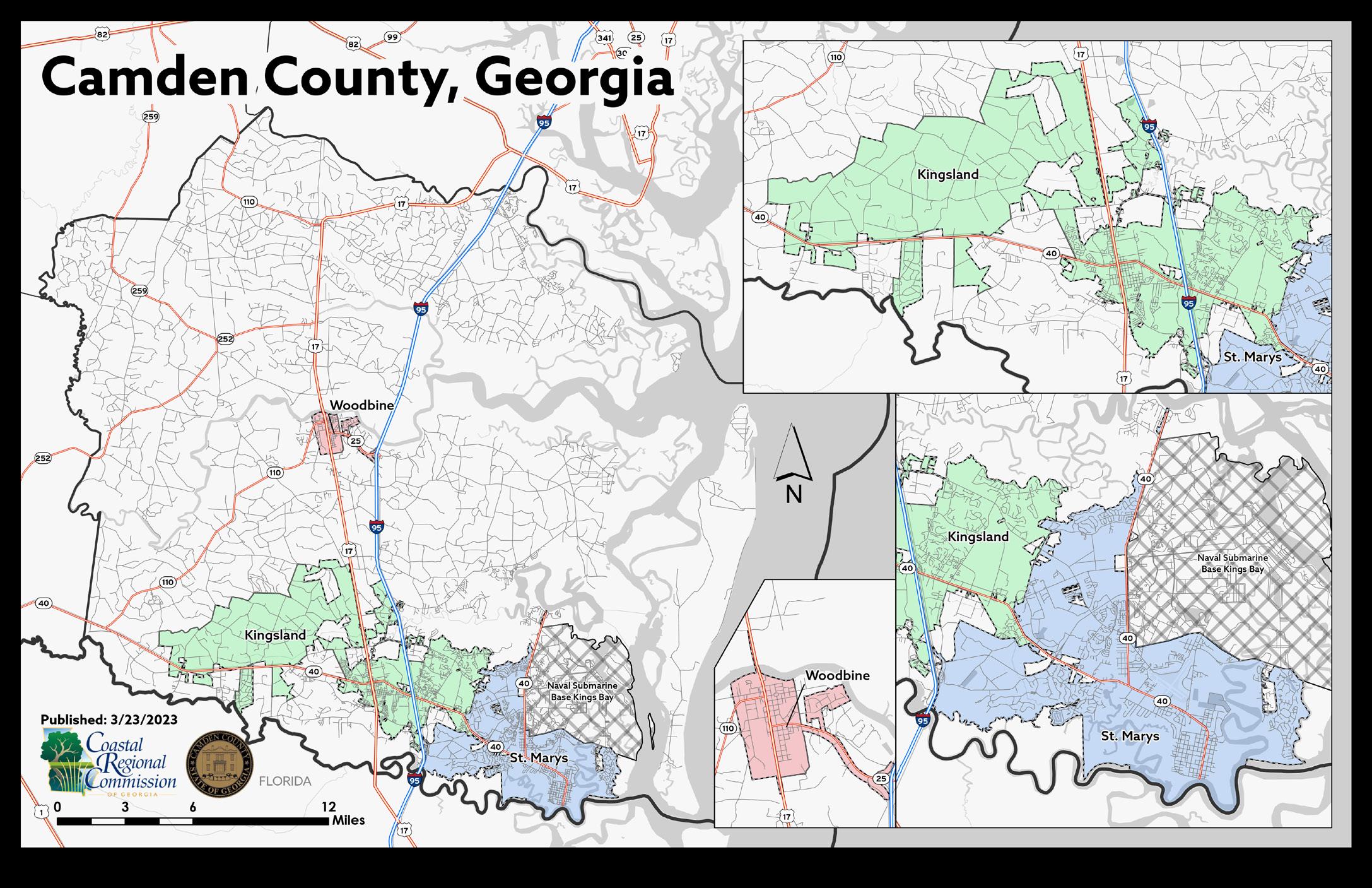
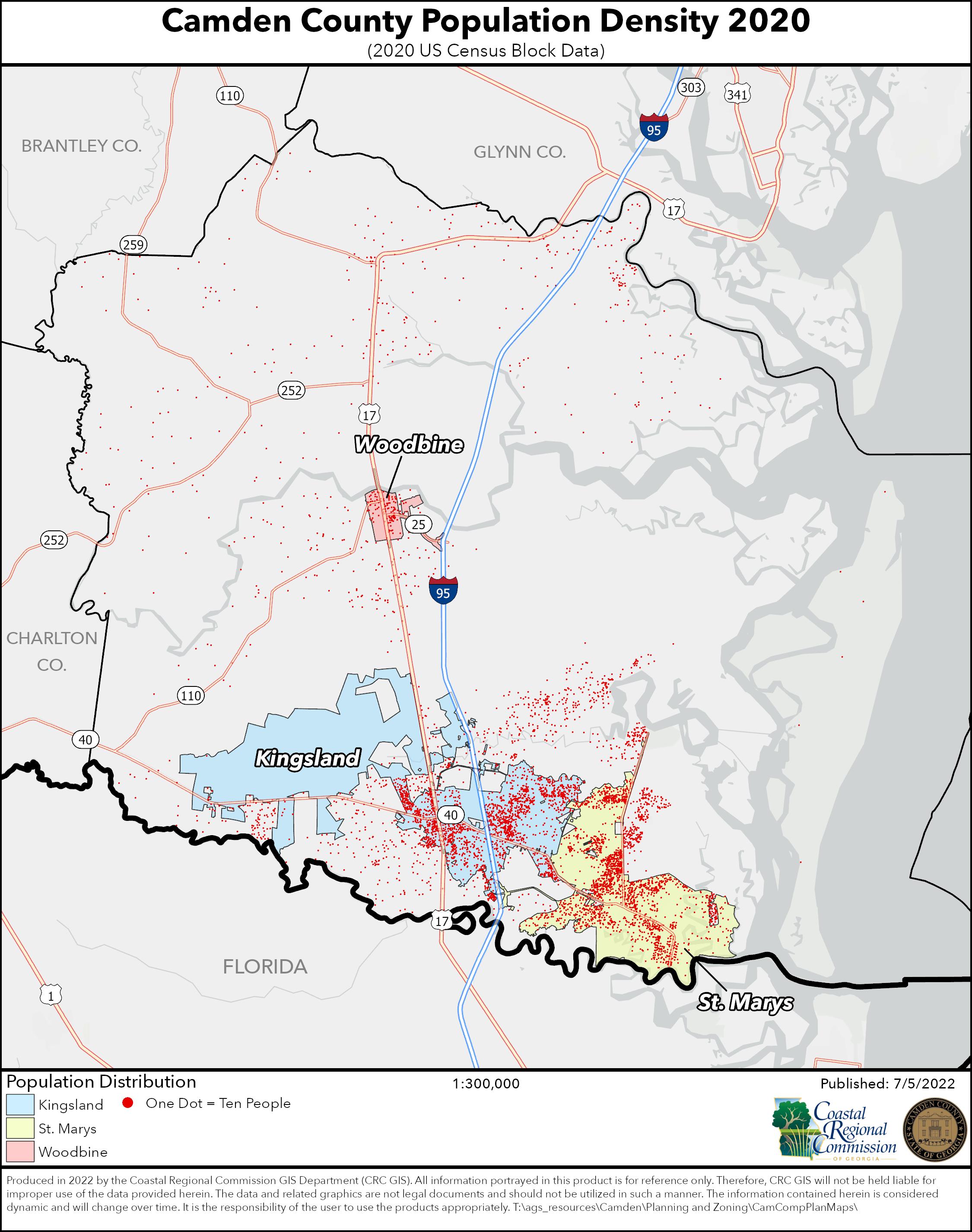
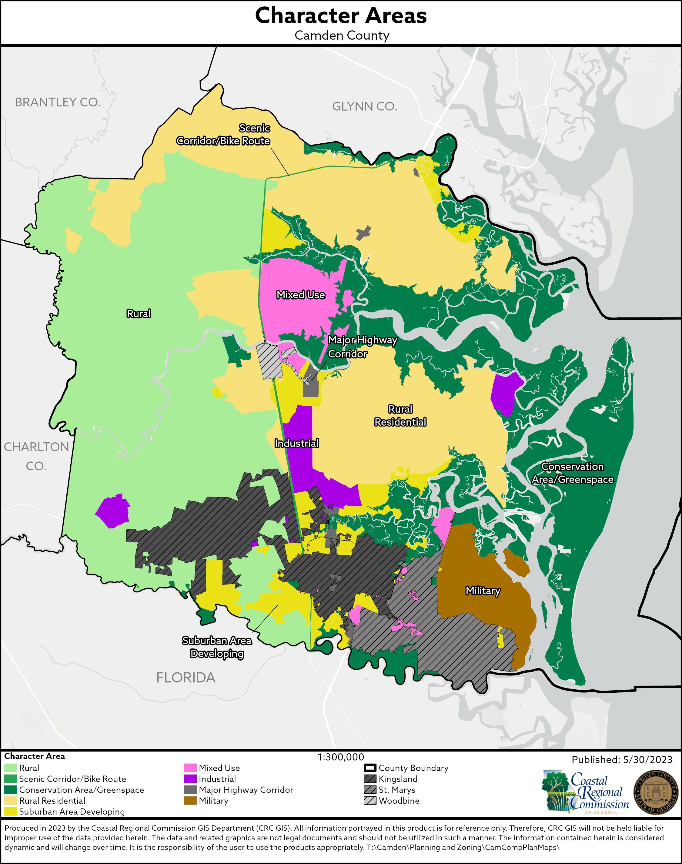
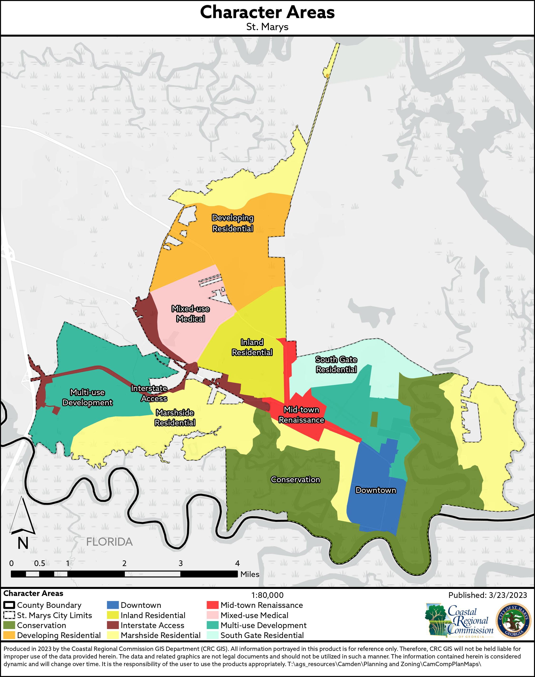
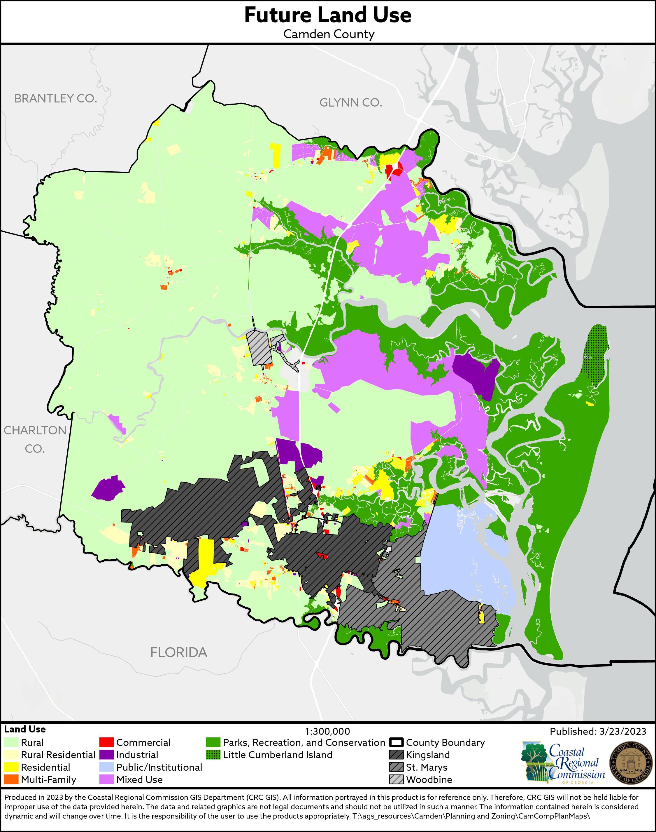
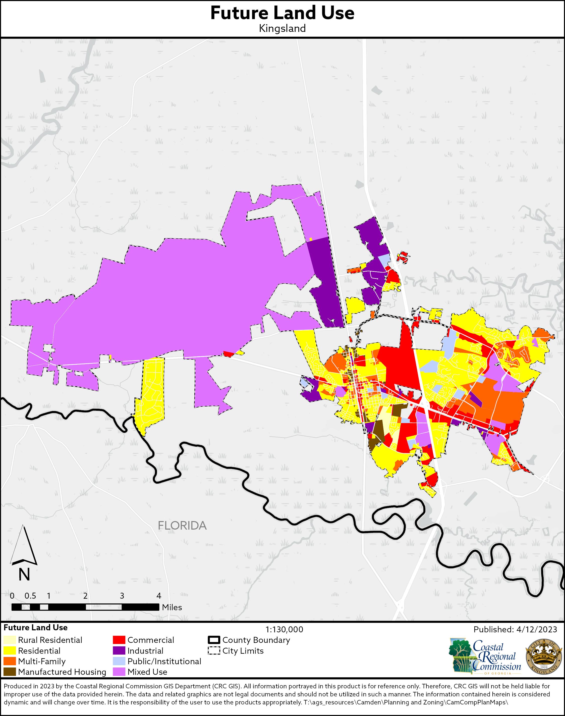
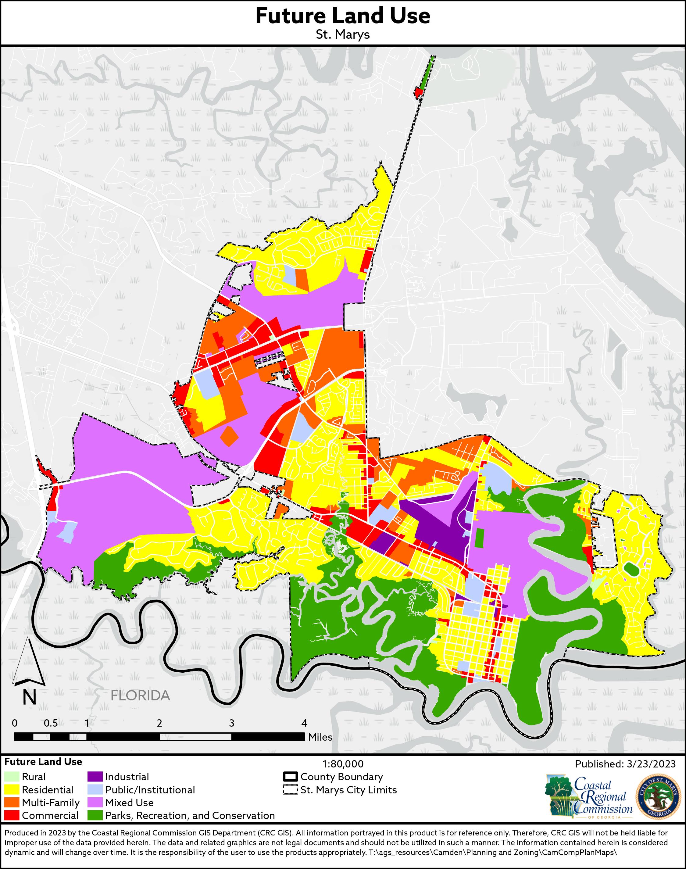
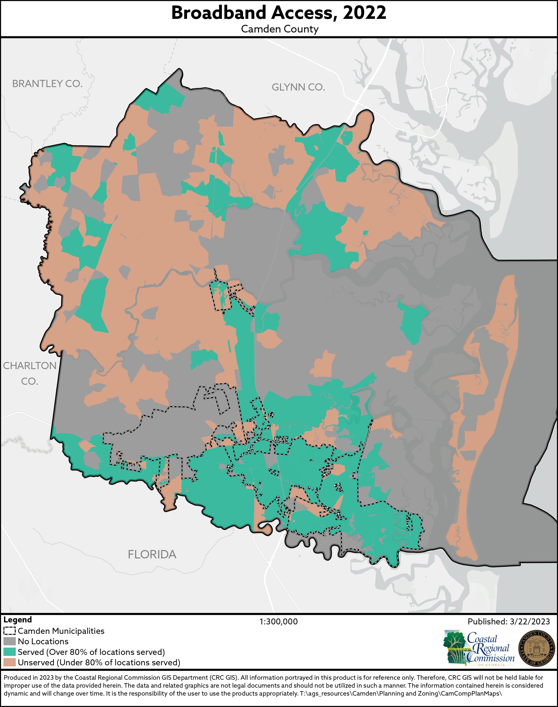
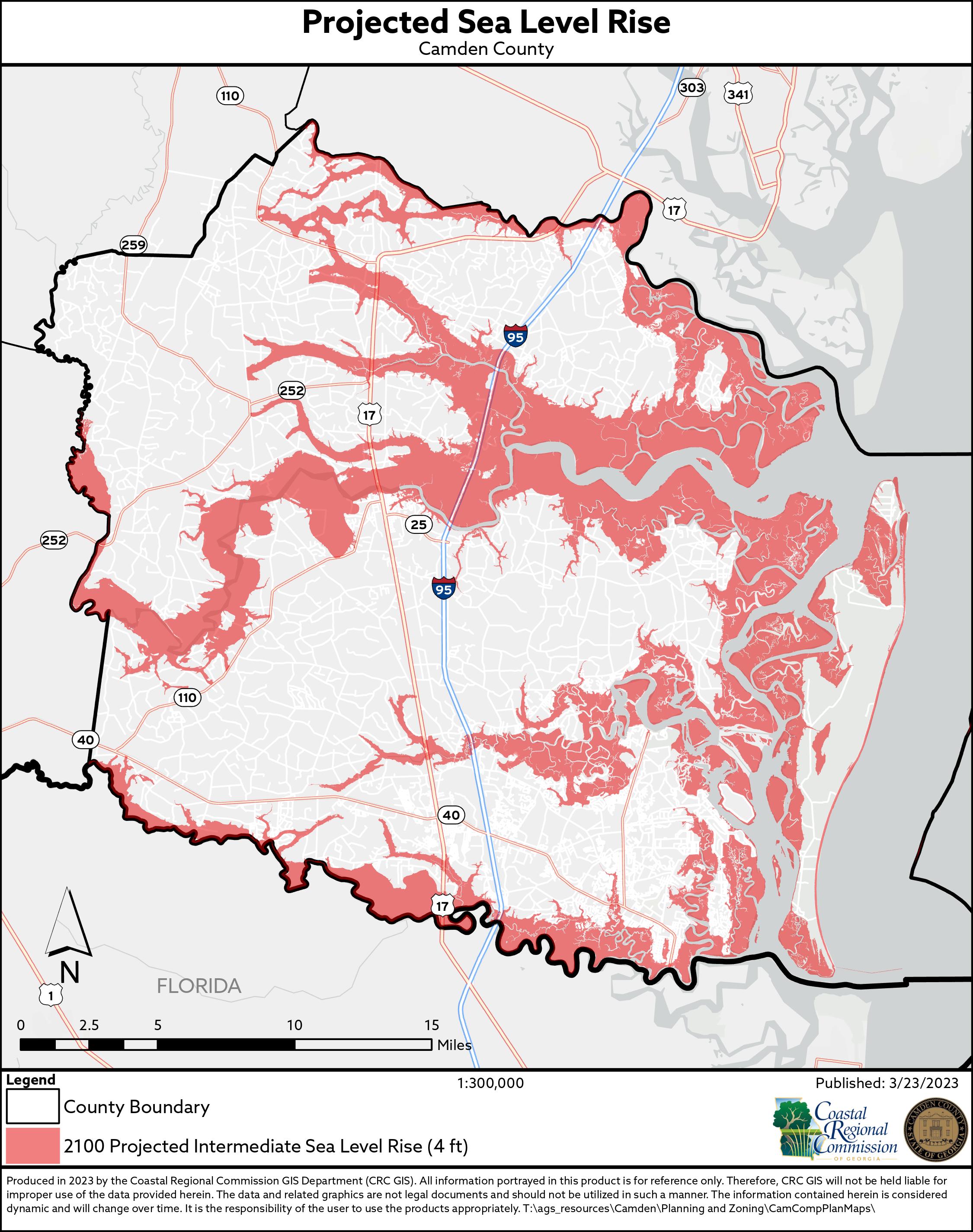
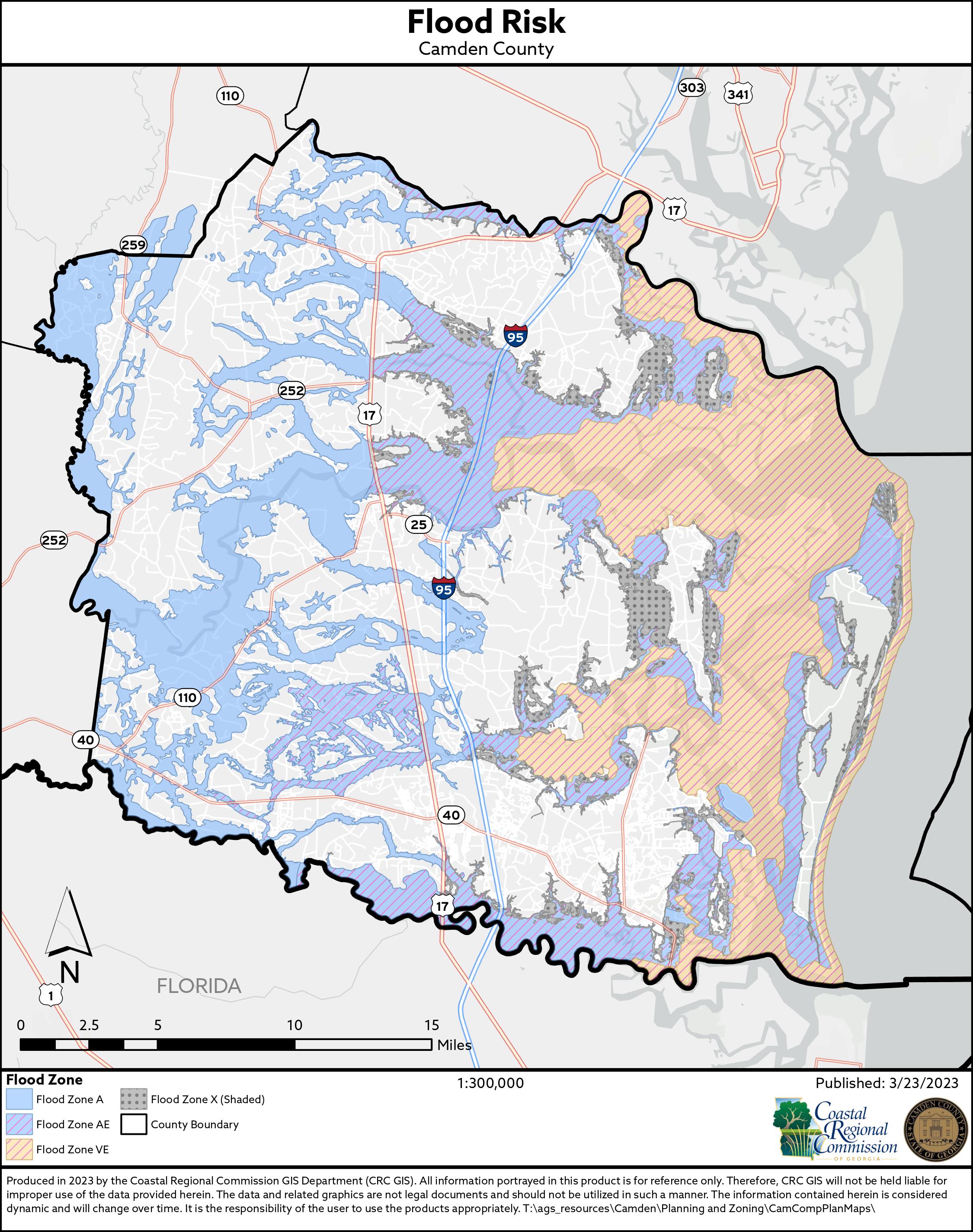
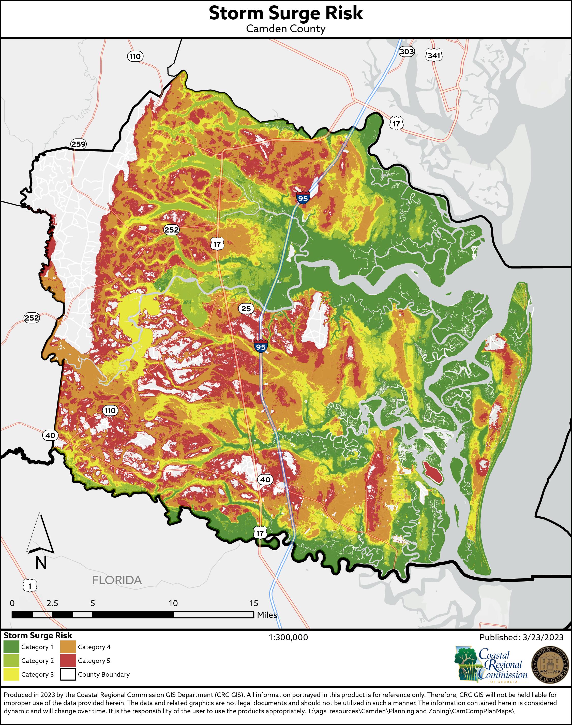
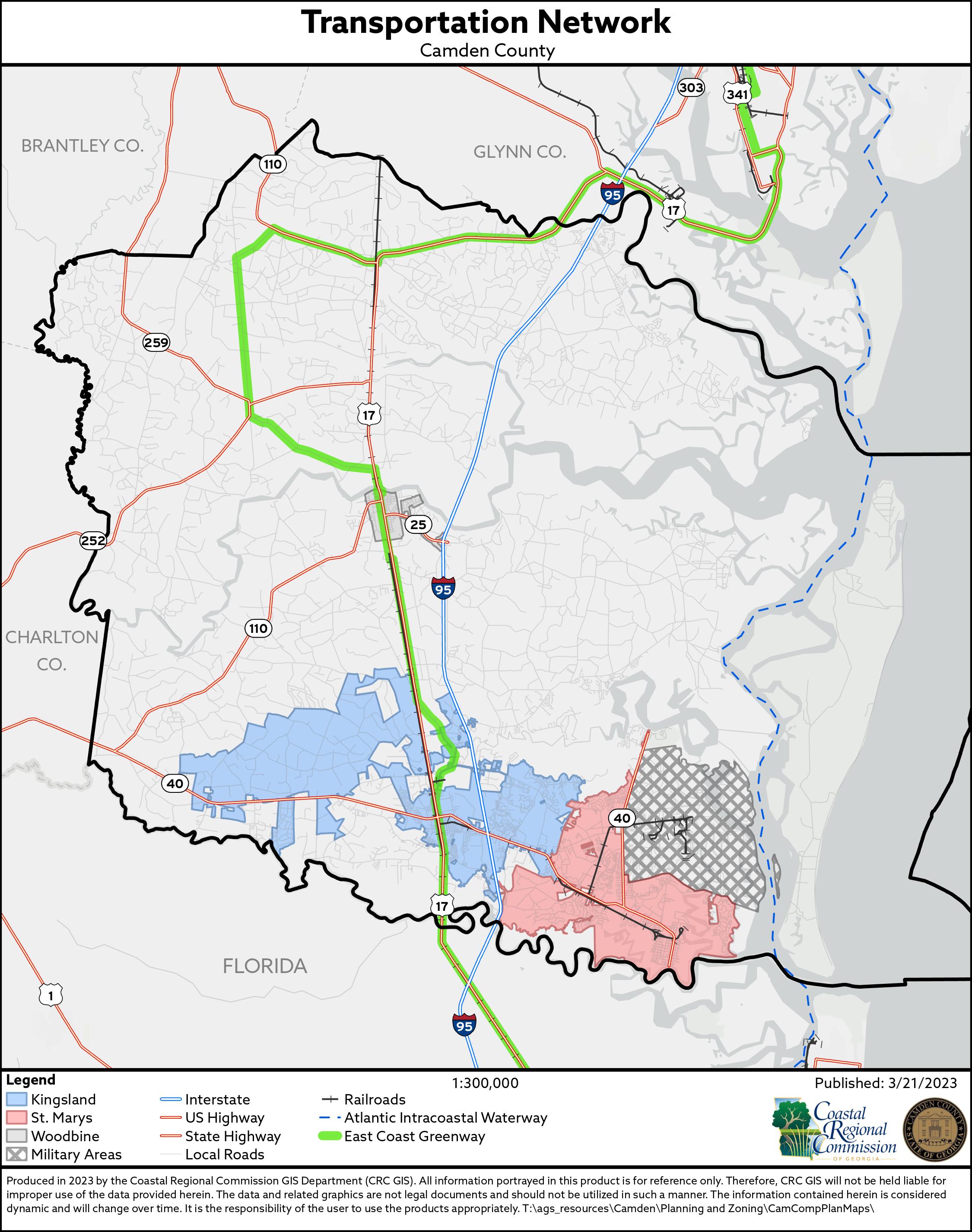
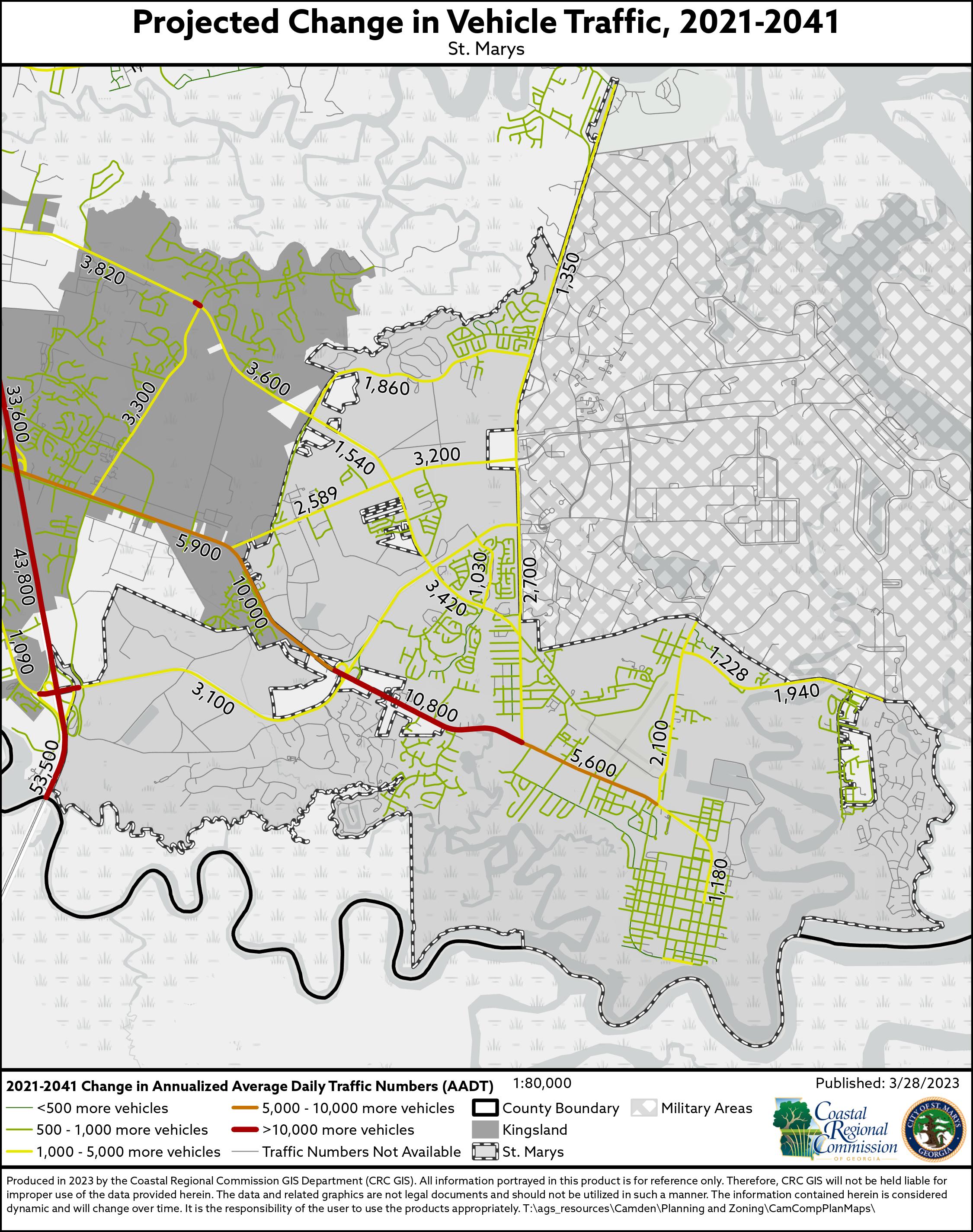
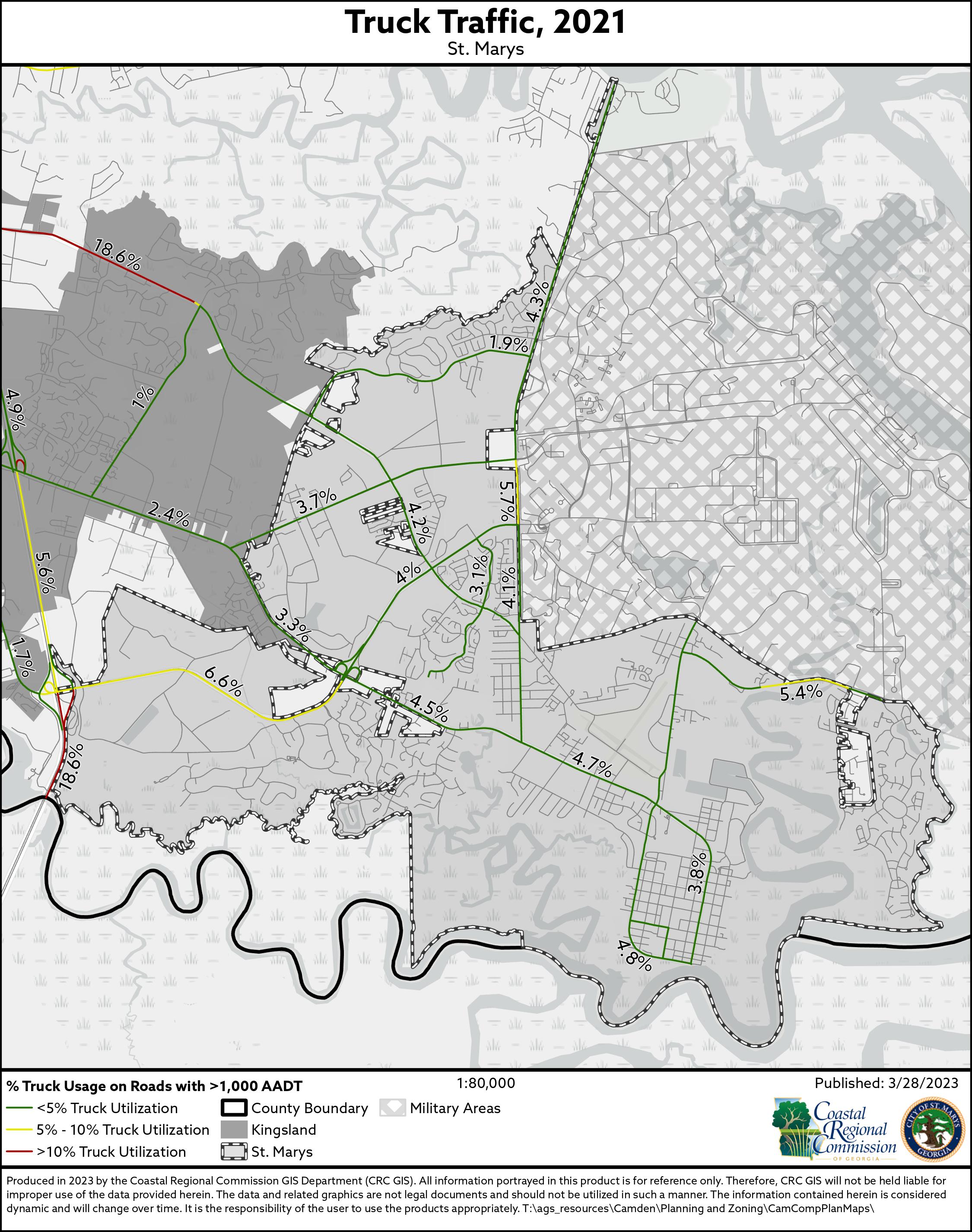
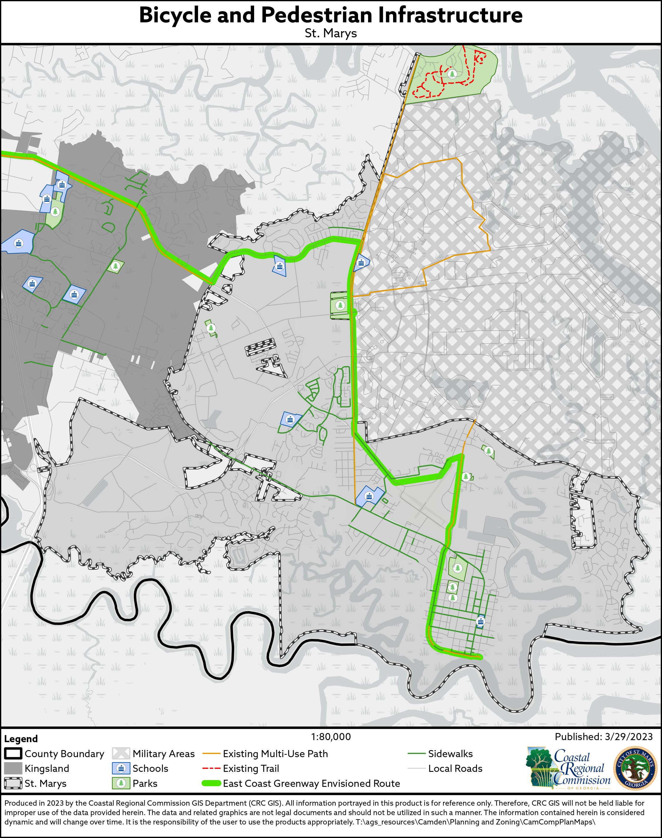
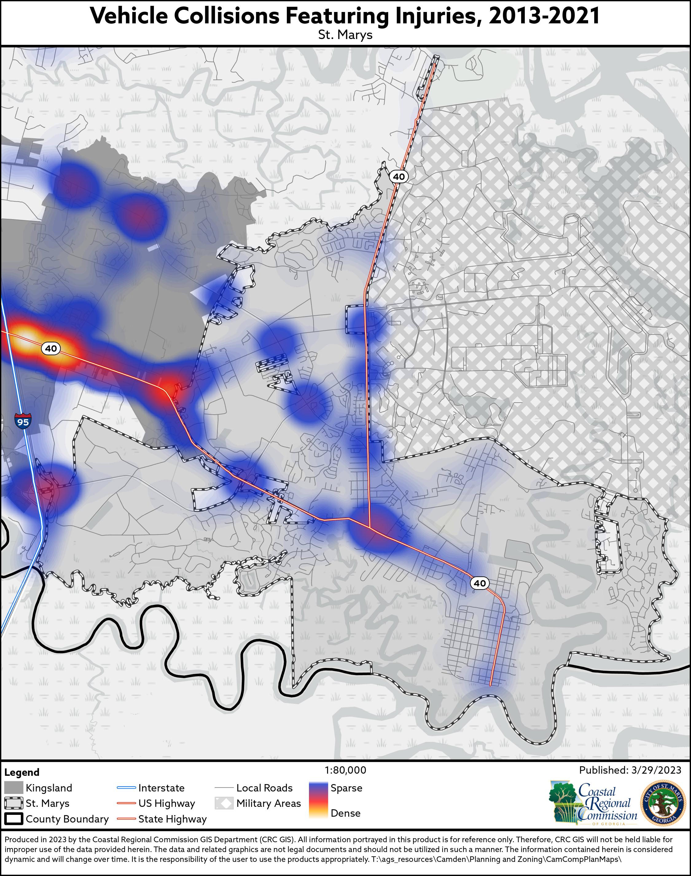
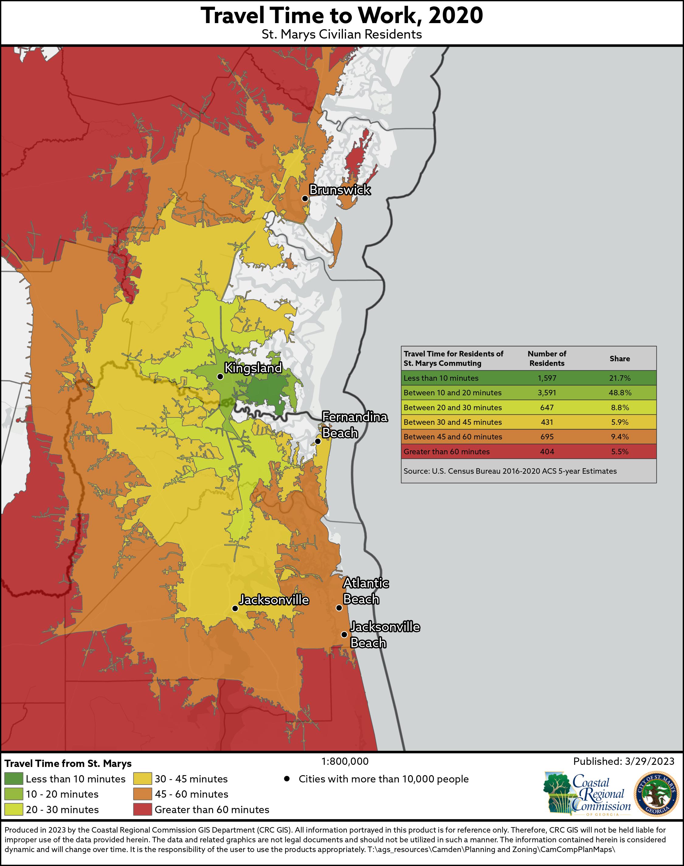
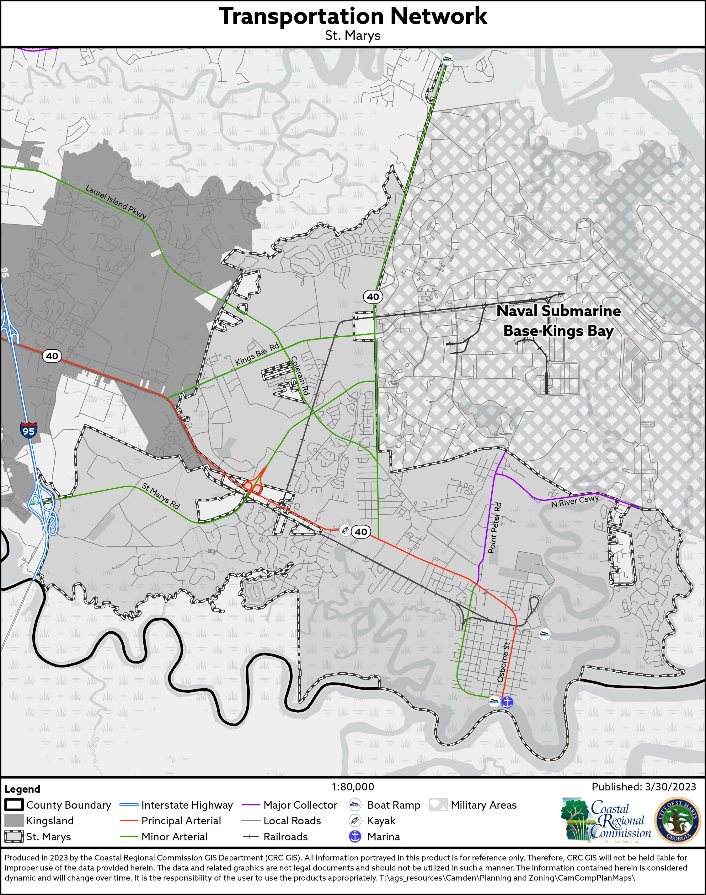
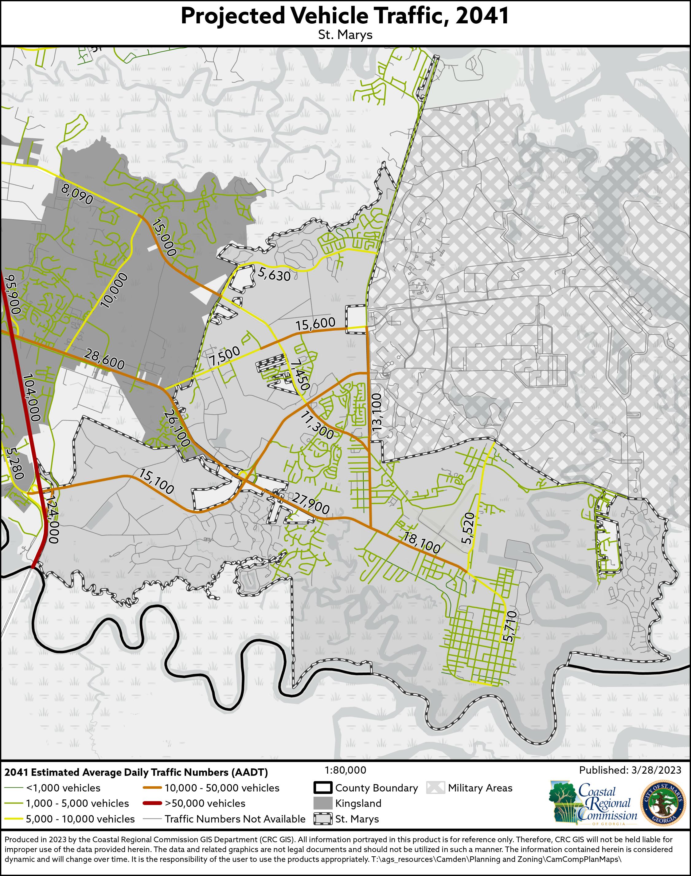
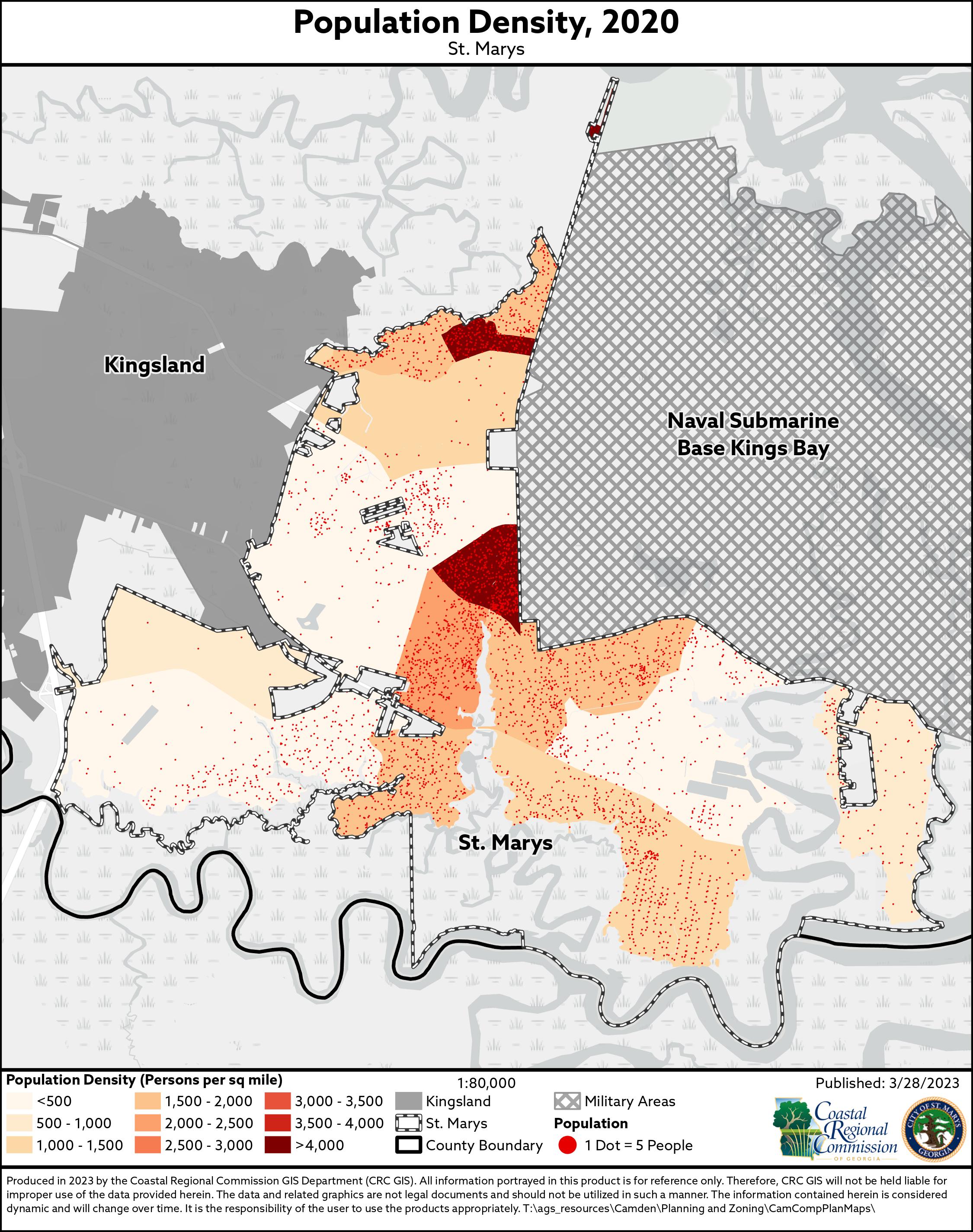
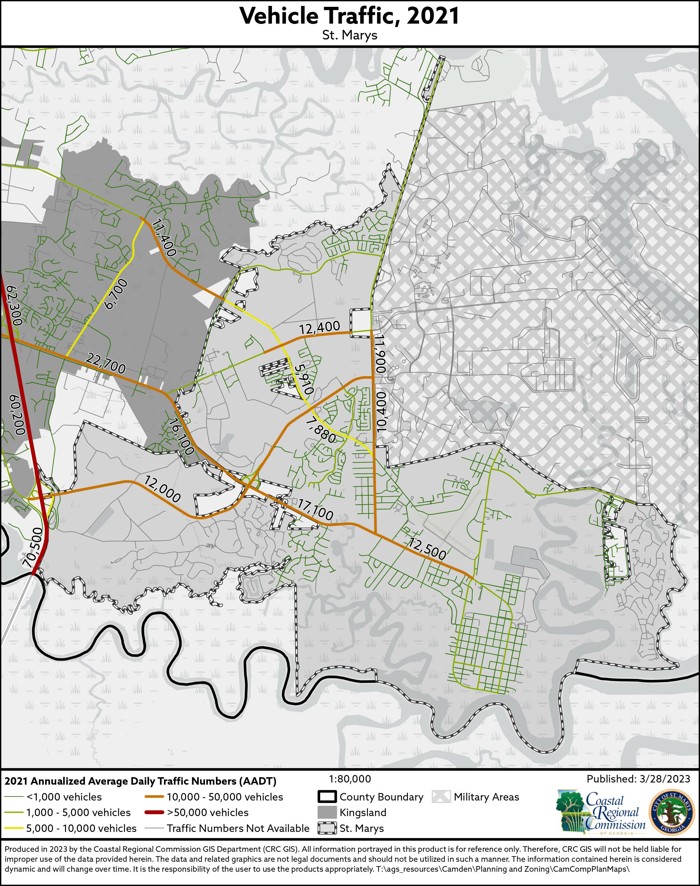

Leadership Southeast Georgia, a professional development and leadership program held throughout 10 coastal counties, concluded its 2022 programming with a focus on regional health and infrastructure.

The participant group consists of regional leaders from business, professional and civic organizations selected to participate in a five-month course of ongoing personal and professional growth to build connections and learn collaboration skills that empower them to improve the
region. Day one of the fifth and final session began in Savannah with a welcome from Savannah Mayor Van Johnson and Chatham County Board of County Commissioners Chairman Chester Ellis. The group then toured the Waters College of Health Professions building at Georgia Southern University’s Armstrong Campus before a panel presentation by local stakeholders in public health. The afternoon session included a private tour of
Enmarket Arena, and a dinner was held at Trustees Garden with a discussion with Charles Morris about cooking healthy.
A morning presentation from a panel of experts at Georgia Ports Authority opened the second day’s session, as infrastructure took center stage. The class members also toured the port and presented their group capstone projects. After lunch, a boat tour with speakers from local industry, development and tourism sectors closed out the day.
On Friday morning, the participants completed a final collaboration exercise before the graduation ceremony at Thomas & Hutton. Ellen Bolch, President and CEO of THA Group, delivered a keynote speech to the graduates, who received their plaques and certificates immediately following. Camden County real-estate agent Julie Streit was one of the graduates of the leadership class. Other class members included Chris Barr, Darrell Boazman, Karen Bogans, Cher-
ise Cartright, Dialo Cartright, Sharri Edenfield, Mandy Edwards, Alisha Erves, Kristin Fulford, Peyton Fuller, Ronnie Hall, Nick Harty, Col. Manuel Ramirez, Jen Roberts, John Robertson, Jason Smith, DJ Spisso, Travis Stegall, Joe Tallent, Gena Taylor, Jessica Thomas, Sam Tostensen, Nick Westbrook and Tre Wilkins.
To learn more about Leadership Southeast Georgia, visit lsega.com.
Submitted by Leadership Southeast Georgia
Herb gardening is popular amongst gardeners, and even those who don’t consider themselves gardeners often enjoy dabbling in herb gardening. Herbs can be grown indoors or out, in pots or beds, at any skill level. Fresh herbs can add bursts of flavor to food or beverages, be used in teas, used medicinally or used as home decoration and potpourri.
Herbs are non-tropical plants, of which leaves or stems are used as flavoring, medicine or fragrance. They can be distinguished from spices, which are usually the products of roots, seeds, bark or fruits of tropical plants. Herbs prefer well drained, loamy to sandy soil with a pH range of about 6 to 7.5, and only require moderate fertilization. A soil test is best to amend properly for pH and nutrient needs. Herbs generally require at least six hours of sunlight, and you will find that raised beds and natural mulch help herbs to flourish by improving drainage and soil temperatures.
Herbs are propagated from seed, stem cuttings, division and layering. Direct seeding in the spring can be successful, but seeding is more successful if begun indoors in late winter. It’s important to use clean flats, which are deep enough to give the root area a proper amount of space for growth. Fill the container with moistened mix and firm the surface. Make shallow indentations, and sow the seed evenly at the same depth given on the package. Most seeds are planted at a depth about twice their diameter. Very small seeds should be simply pressed gently into the surface of the soil and barely covered.
After planting, lightly water the surface and place the container in a warm, well-lighted area or under fluorescent lights, not in direct sunlight.

When the seedlings have two or three leaves, they may be transplanted into small pots or, if the frost-free date has passed, into the garden.
“Harden-off” transplants by putting their containers outside in light shade for a few days before planting them in the garden. Water the transplants well initially and for the first week after planting.
Herbs such as lavender, rosemary and lemon balm can be propagated through cuttings. In spring or summer, cut 3 to 5 inches of new growth containing two or more nodes. Make the cut just below a node where a leaf joins a stem, remove the lower leaves, dip the cut end in rooting compound and insert the cuttings into the potting medium past the
first leaf node. The medium should be kept slightly warm and moist until cuttings have rooted, usually about three to six weeks.
Herbs that form clumps with many fibrous roots can be divided. Simply slice through a section of the mass with a shovel, or dig up the entire plant, split the mass and replant the divisions. Water well after transplanting to promote root-to-soil contact for quick re-establishment. Herbs that can be propagated by division generally benefit from being dug up and divided every few years.
Layering is another simple method of propagation. To propagate by layering, bend a portion of a stem to contact the soil, pinning it in place until rooted, then remove and plant the rooted portion.
Layering can be done in the spring or summer. If done in late summer, the plant can be left over the winter and transplanted the following spring.
Herbs can be grown indoors if the right amounts of sun and moisture are provided. Herbs need to receive at least four to six hours of sunlight each day. Don’t assume herbs near windows automatically receive enough light for growth. Herbs will grow tall and spindly in inadequate light. Rotate the plants periodically so that all sides receive enough light and pinch them back to promote bushiness. Plants grown
indoors will generally not grow as fast as those grown outdoors, and there will not be as many leaves to harvest.
Water herbs only when they are dry. If the soil feels at all moist 1 inch below the surface, do not water the plant. Over-watering increases the chance of disease and may eventually block necessary oxygen to the roots.
Herbs grow well in urns, hanging baskets, strawberry pots and other containers as long as the light, moisture and fertility requirements are met. Use a good lightweight, well-drained artificial soil mix, not garden soil, for container-grown herbs. Since container-grown herbs do not have access to surrounding soils, they are more likely to dry out quickly. They must be watered regularly, sometimes daily. Containers should have drainage holes so excess water can escape. Regularly empty any water in the saucers under containers to prevent roots from deteriorating. Uniform monthly fertilizing keeps herbs lush, but be careful to avoid fertilizer salts build-up.
Herbs grown for foliage may be harvested at any time; though, the essential oils are most concentrated just prior to blooming. The seedheads of herbs grown for their seeds, such as fennel and dill, may be collected soon after
COMPREHENSIVE PLAN UPDATE
June 27, 2022 • 6:00 PM
City Council Chamber at City Hall 107 South Lee Street, Kingsland, GA 31548
You are invited to participate in the planning process for the future of Kingsland.
This is your opportunity to share ideas, voice concerns, and describe your vision for Kingsland. In addition, the Coastal Regional Commission Planning Staff will be present to introduce the planning process. Kingsland encourages all interested parties to take part in this process. The first meeting will take place on June 27, 2022, at 6:00 PM. It will be held at City Hall in the City Council Chambers.
Citizens who are unable to attend but would like to provide comments regarding the plan can contact Hannah Mendillo, Regional Planner, at hmendillo@crc.ga.gov.
seeds have reached maturity. Herbs are best collected in the late morning, rinsed quickly and air dried. Drying or freezing will preserve them. The ideal conditions for drying herbs is a warm, dry, dark, well-ventilated place. The simplest method is to tie herb stems together in small bunches and hang the bunches upside down from a rod or rafter. The bunches should not touch so that air can freely circulate around them. Herbs to be dried for seed collection can be enclosed in large paper bags with holes cut into the sides for air circulation. Herbs may be dried in a gas oven at very low temperature, about 100 degrees F (electric ovens cannot usually be set at this temperature). Strip the leaves from the stems and place them in a single layer on a wide, flat sheet or pan. With the door of the oven ajar, the herbs should dry sufficiently in about three to five hours. Stir herbs gently every 30 minutes during the drying process. Store herbs away
from heat out of direct light. If moisture forms on the inside of the storage container, re-dry the herbs. Herbs are prepared for freezing by a quick rinsing, then by shaking off the excess moisture and patting the leaves dry. Remove the leaves from the stems, put in labeled freezer bags and store in the freezer. An alternative method is to drop the leaves into ice trays, fill with water and freeze. The quality of frozen herbs will usually begin to
deteriorate after about three to six months, and strong-flavored herbs, such as chives and rosemary, may affect other foods in the freezer and should be stored in freezer jars. Herbs don’t have to have their own containers or beds (except anything in the mint family, including lemon balm – these plants will take over your landscape if not controlled). They can easily and beautifully integrate into your landscape and flower beds. Herbs can add scent, texture and bloom variety to the landscape, and many can make attractive edging plants. Many of our common herbs are also strong pollinator attractants. Luckily some of our herbs that are easiest for beginners are also some of the most beloved. This list includes mints, basil, oregano, sage and chives.
Jessica Warren is the extension agent for Camden County. To learn more, call the office at 912-576-3219, send an email to jkwarren@uga.edu or visit extension.uga.edu/county-offices/camden.html.

Saint Jude Novena
May the Sacred Heart of Jesus be Adored, Glorified, Loved and Preserved throughout the world now and forever! Sacred Heart of Jesus, Pray for us. Saint Jude worker of miracles, Pray for us. Saint Jude helper of the hopeless, Pray for us. Say this 9 times a day, by the 8th day your prayer will be answered. It has never been known to fail. Publication must be promised.
77235 RAB 061622V3
“Thank You Saint Jude” for granting my petition. R.A.B.
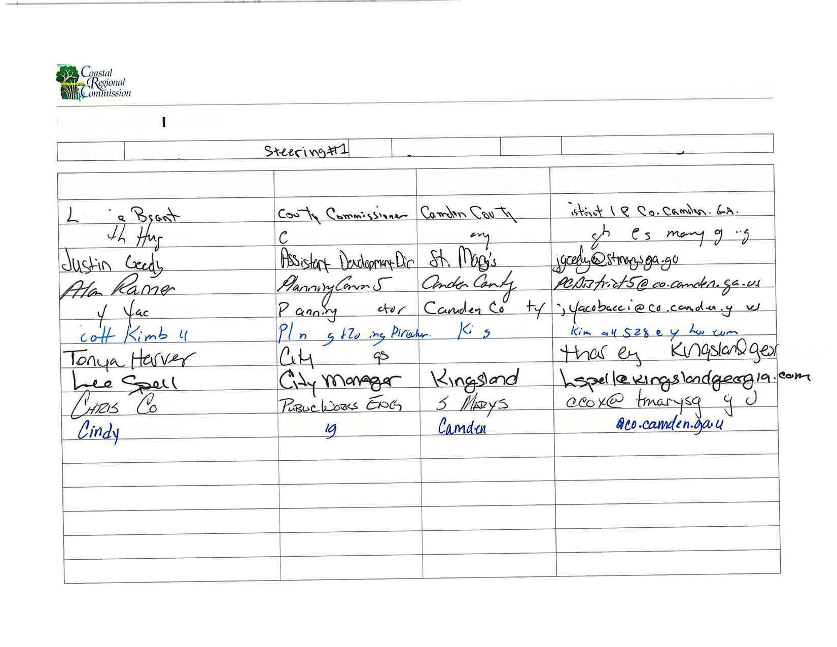
Steering Meeting #2
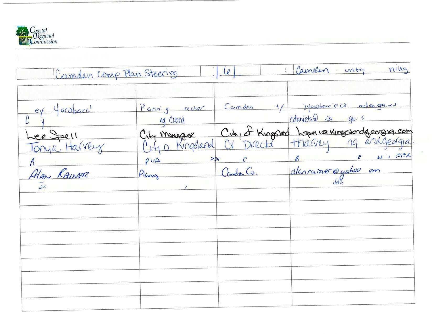
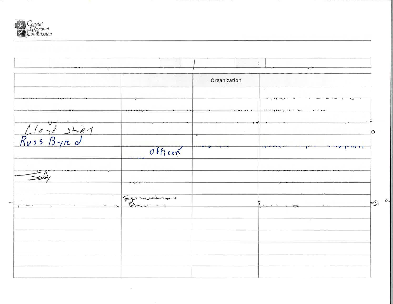
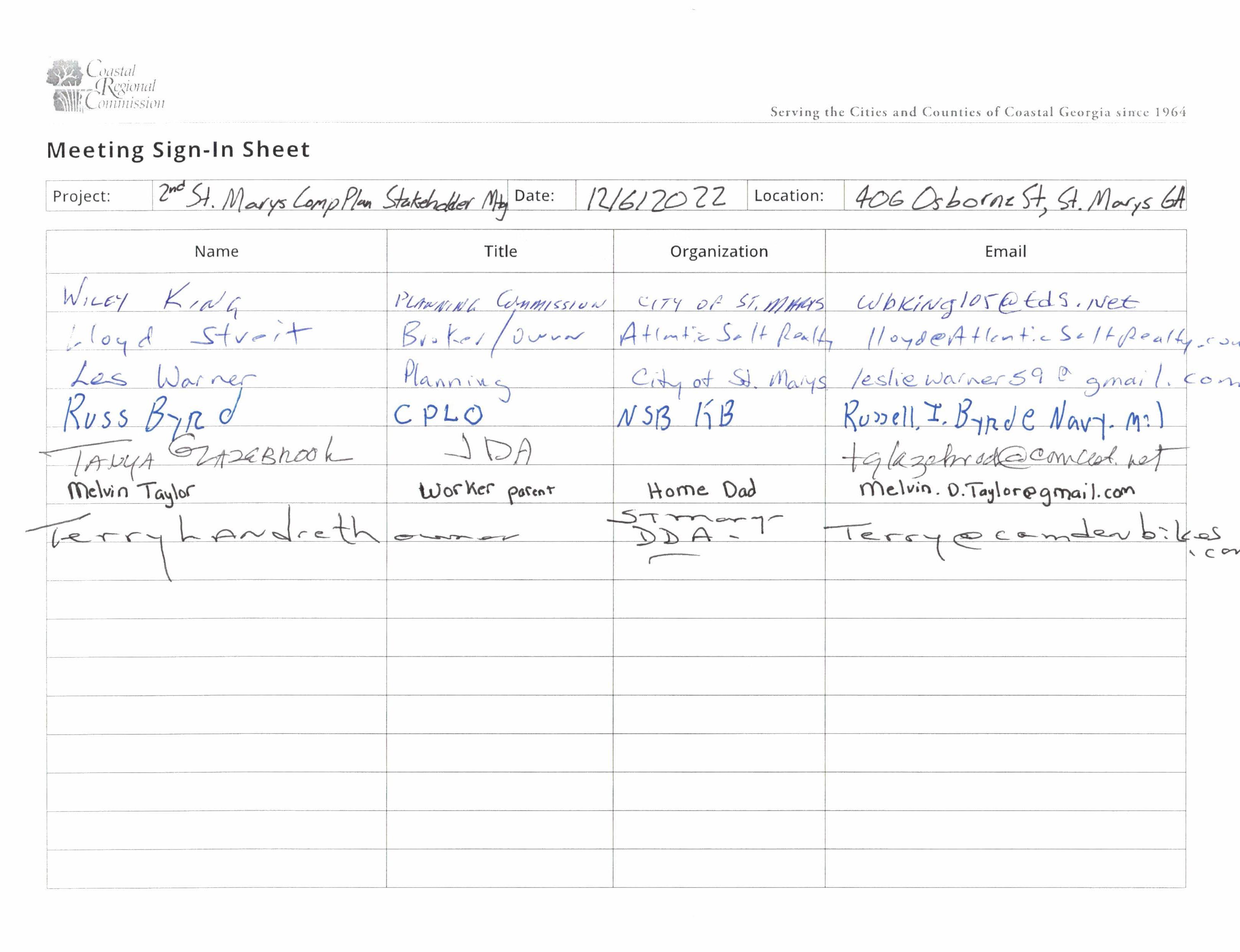
Camden County Stakeholder Meeting #1
Camden County Stakeholder Meeting #2
Camden County Stakeholder Meeting #3
Kingsland Stakeholder Meeting #1
Kingsland Stakeholder Meeting #2
Kingsland Stakeholder Meeting #3
Where do you live? 1.
St. Marys Kingsland Woodbine
Unincorporated Camden County Kings Bay
I'm not sure if I live within city limits Other
What is your zip code? 2.
Kingsland Stakeholder Meeting #3
3.
How long have you lived in Camden County?
Less than one year
1-5 Years
5-10 Years
10-20 Years
20+ Years
Where do you work?
St. Marys
Kingsland
Woodbine
Kings Bay
Unincorporated Camden County
I am retired
I am currently unemployed
Other
Kingsland Stakeholder Meeting #3
Do you rent or own your place of residence? 5.
I rent
I own My home is outside of Camden County
How old are you?
Under 18
What are the best parts of your community?
Kingsland Stakeholder Meeting #3
8.
What challenges does your community have to overcome?
9.
What are the biggest impacts on your quality of life?
Kingsland Stakeholder Meeting #3
10. Satisfied
Please rate your satisfaction with each of these aspects of your community:
Somewhat satisfied
Somewhat dissatisfied Dissatisfied
Not applicable
Trash Pickup
Parks and Recreation
Drainage/Flo oding
Cleanliness of Public Spaces
Public Water and Sewer
Fire Services
Law Enforcement Code Enforcement
Condition of Infrastructure (Streets, lights, etc)
Housing Development and Opportunities
Economic Development and Opportunities
Kingsland Stakeholder Meeting #3
11.
If you would like to elaborate on any of your responses to the previous question please do so here:
12.
What do you do for fun in Camden County?
13.
What things would you love for Camden County to have?
Please provide any additional thoughts on the future of Camden County: 14.
15.
If you would like to receive updates about the planning process and invitations for future involvement, please share your email below, so we can add you to our mailing list.
This content is neither created nor endorsed by Microsoft. The data you submit will be sent to the form owner.


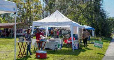

Camden County
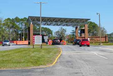

Scenic Corridor/Bike Route

Suburban Area Developing
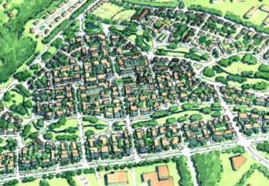
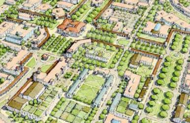
Major Highway Corridor
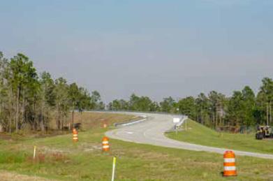
Military

St. Marys Conservation
Downtown
Inland Residential
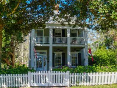
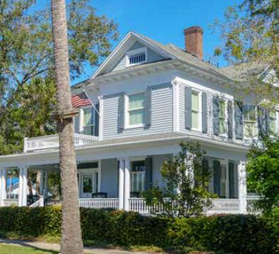
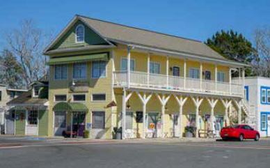
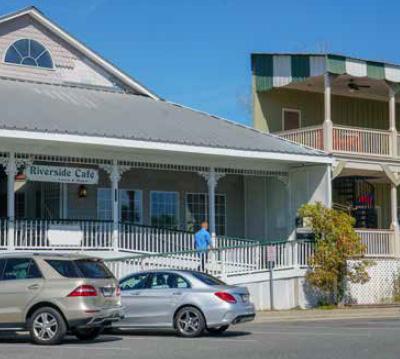
Interstate Access Corridor
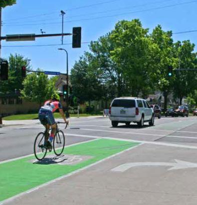


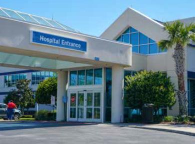
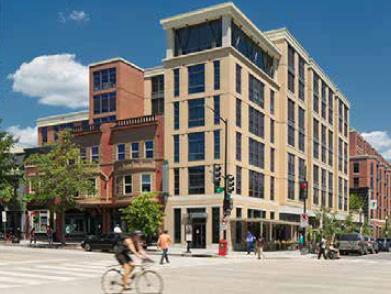
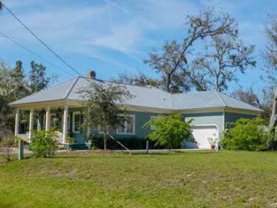
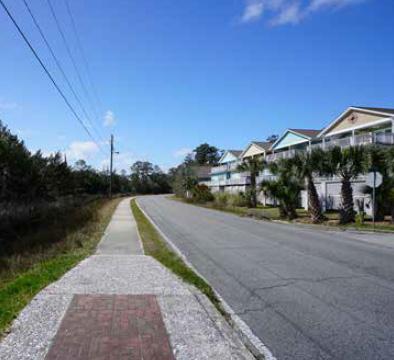 Marshside Residential
Midtown Renaissance
Mixed Use Medical
Marshside Residential
Midtown Renaissance
Mixed Use Medical
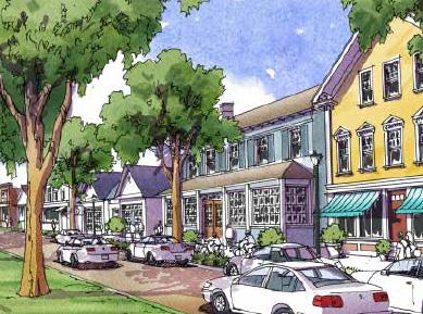
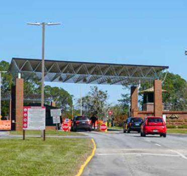
Name(s) of Submitting Government(s):
Camden County, City of Kingsland, City of St. Marys
RC:
Submittal Type:
CRC
Adopted 2023 Comprehensive Plan
Preparer: x
RC Local Government Consultant: Specify
Cover Letter Date: 6/28/23
Date Submittal Initially Received by RC: 6/28/23
Explain Unusual Time-lags or Other Anomalies, when present:
Inaccurate/incomplete information, above, and nonconformity with the standards articulated, below, are reportable as performance errors under the terms of the annual DCA/RC contract and may lead to adverse audit findings.
ALL SUBMITTALS MUST BE TRANSMITTED ELECTRONICALLY USING THE DEPARTMENT’S SHAREPOINT SITE.
COMBINE ALL INDIVIDUAL IMAGES, DOCUMENTS AND SPREADSHEETS INTO ONE SINGLE, SEARCHABLE PDF (INCLUDING COVER LETTERS, APPENDICES, ETC.), PUT THIS COMPLETED FORM AS THE FIRST PAGE OF THE PDF AND THEN UPLOAD IT.
REVISED SUBMITTALS MUST INCLUDE THE ENTIRE DOCUMENT, NOT ONLY THE REVISED PORTION.
EMAILED OR HARDCOPY MATERIALS WILL NOT BE ACCEPTED FOR DCA REVIEW.
ALL SUBMITTALS MUST BE CHANNELED THROUGH THE APPROPRIATE REGIONAL COMMISSION.