Wh n you corn to T AA' Australia, it's nice to know you'r amongst fri nds. We'll meet you in Cairns, Bri ban or ydney, th n fly you on to your destination providing fri ndly servi e and help all the way. For TAA bookin or holiday , call your Travel Agent, or Air N iugini.
No. 16 March 1979
Paradise, the in-flight magazine of Air Niugini, is published bimonthly by the Advertising and Public Relations Department, Air Niugini House, Jacksons Airport, Port Moresby. Typeset by Air Niugini Printing and printed in Hong Kong by Dai Nippon. For advertising or editorial contact the Advertising and Public Relations Manager, PO Box 7186, Boroko, Papua New Guinea.
Phone: 25 9000 or 273348
Telex: NE22177 or NE22153
Editor: Gerald Dick
Design: Tom Cooke
Art: Rob Kysely
IN THIS ISSUE
5. Bulldog Trail
Bootless Bay
Showjump
Maprik
Lizard Island
Wuvulu
Highway patrol
Operation Drake
PHOTOCREDITS
Bob Halstead
Geoff Saddler
Tom Cooke
Jim Fenwick
David Callard
Brian Mennis
David Bamford
Bruce Lawes
Peter Watling Office of Information
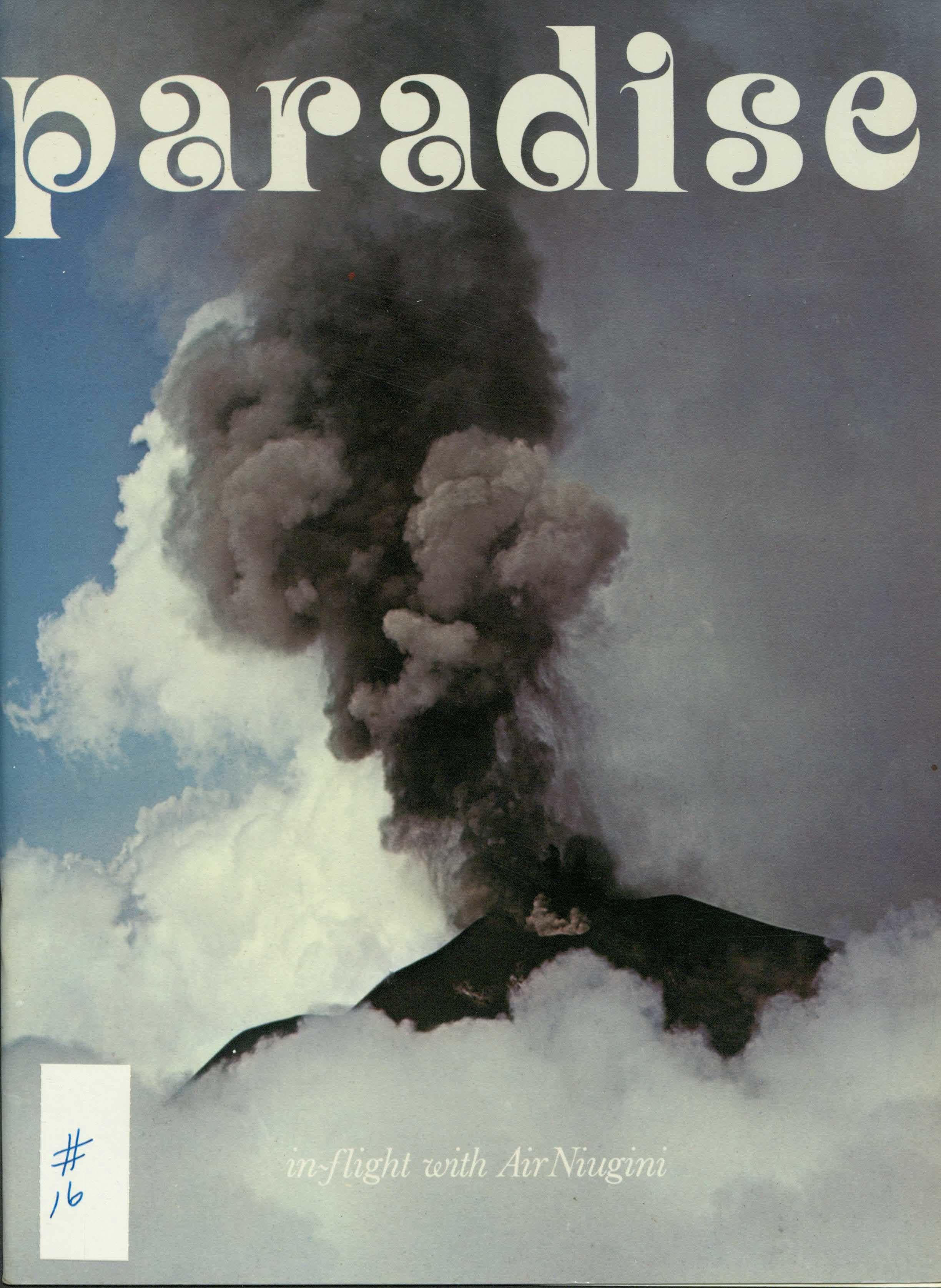
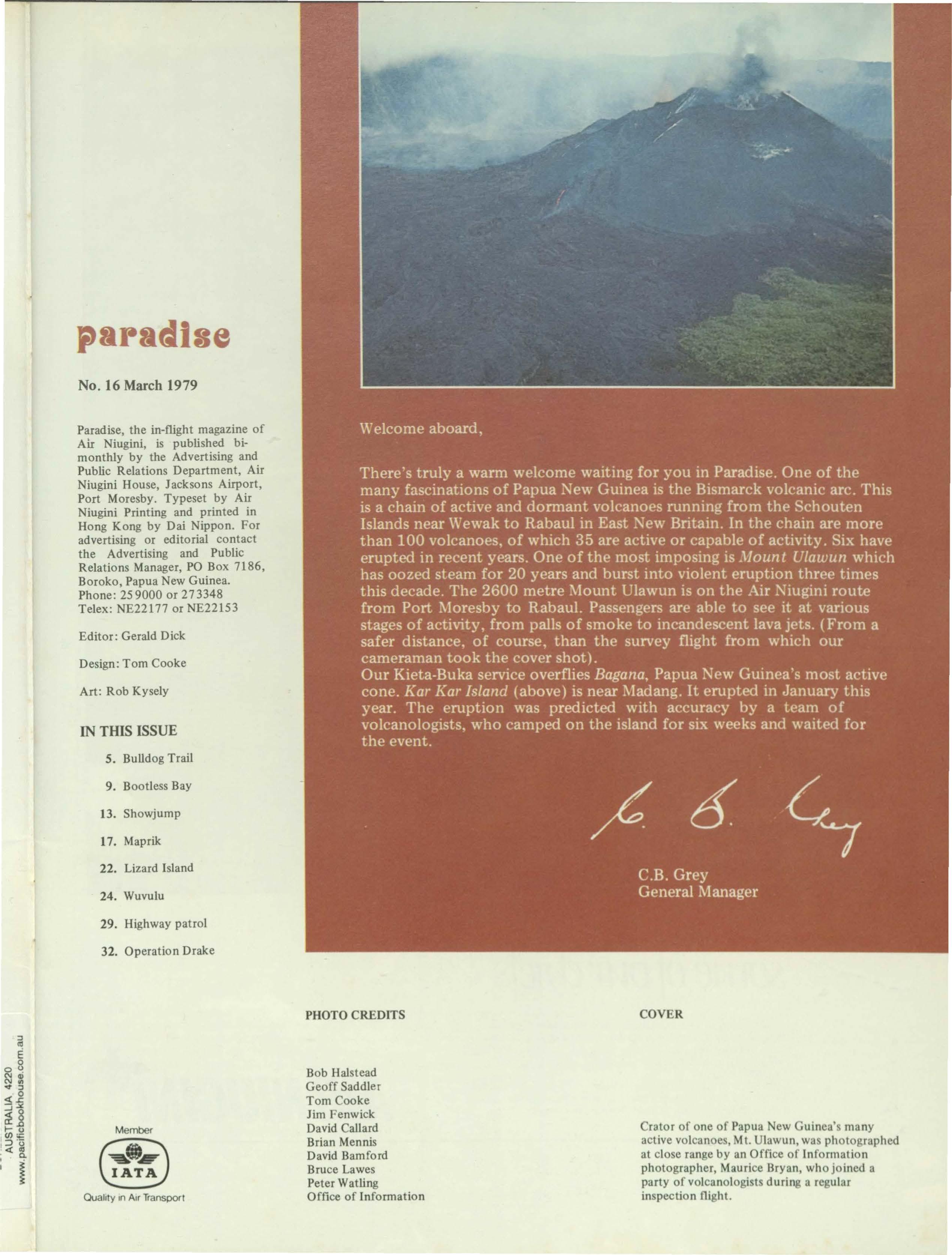
Crater of one of Papua New Guinea' many active volcanoes, Mt. Ulawun, was photographed at close range by an Office of Information photographer, Maurice Bryan, who joined a party of volcanologists during a regular inspection flight.
someofourchiefs
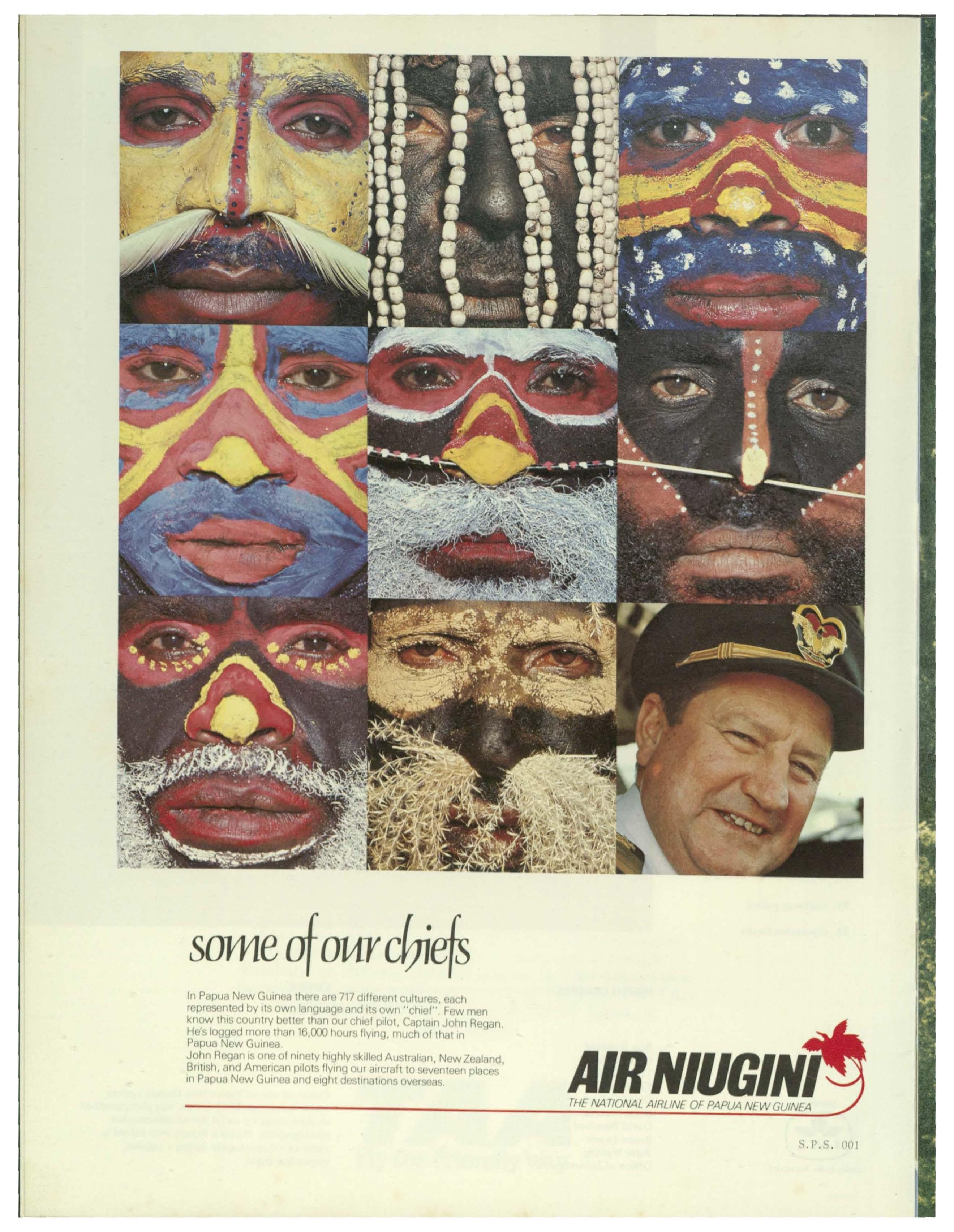
In Papua New Guinea there are 717differ nt CL1ltures,each r pr s nted by its own languag and its own "chief" Few men know this country better than our chi f pilot, Capt,lln John R gan. He's logg d more than 16,000hours fly1nq, much of that In Papua New Guin a John R gan Is on of ninety highly skill d Australian, N w Zealanct, Bnt1sh, nd Am rican pilots flying our aircraft to s vent n places In Papu, New Guin D anct 1gh1cl s11na1Ionsov rseDs
THENA T!ONALAIRLINE OF PAPUANEW GUINEA
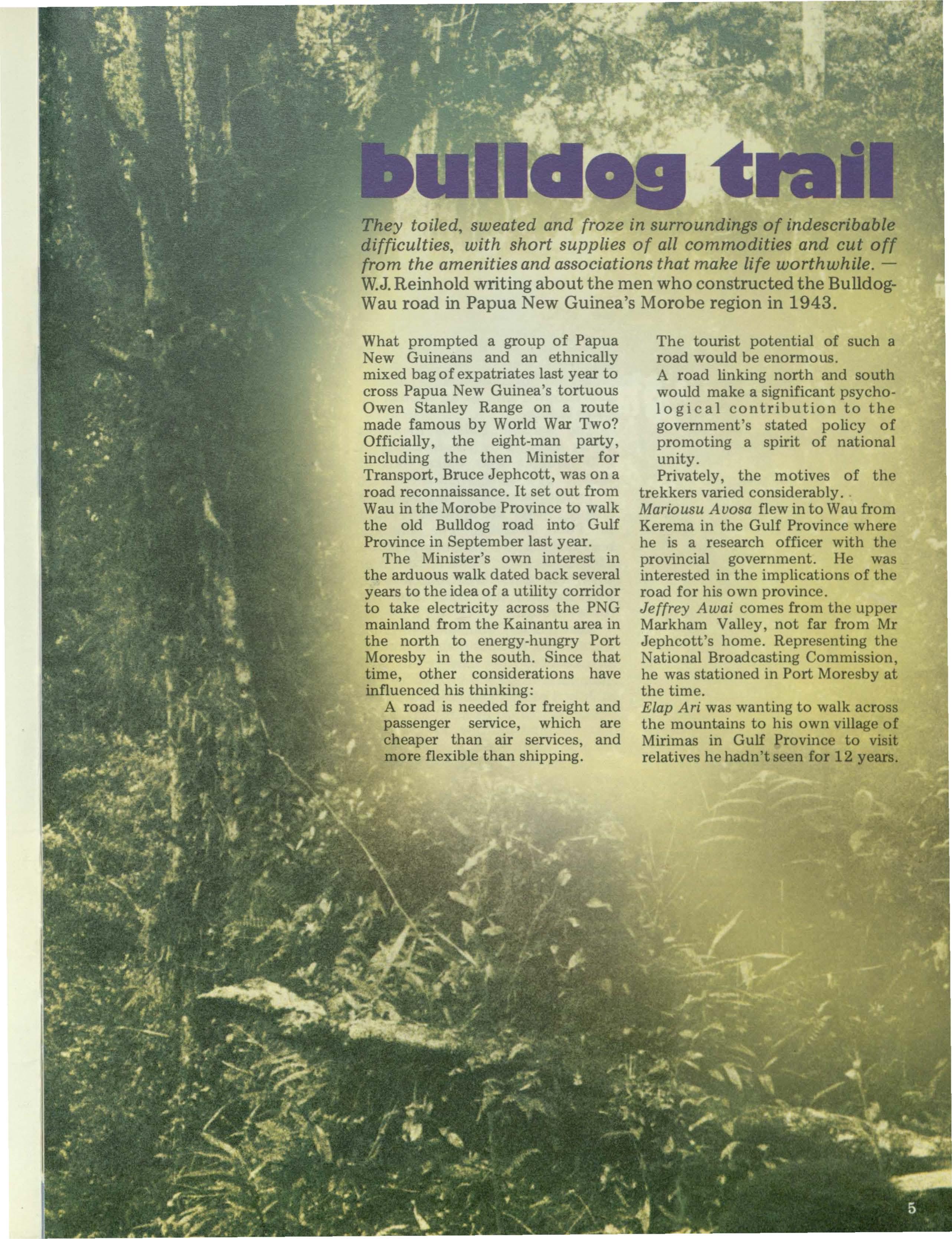
They toiled, sweated and froze in surroundings of indescribable difficulties, with short supplies of all commodities and cut off from the amenities and associations that make life worthwhile.W.J.Reinhold writing about the men who constructed the BulldogWau road in Papua New Guinea's Morobe region in 1943.
What prompted a group of Papua New Guineans and an ethnically mixed bag of expatriates last year to cross Papua New Guinea's tortuous Owen Stanley Range on a route made famous by World War Two?
Officially, the eight-man party, including the then Minister for Transport, Bruce Jephcott, was on a road reconnaissance. It set out from Wau in the Moro be Province to walk the old Bulldog road into Gulf Province in September last year.
The Minister's own interest in the arduous walk dated back several years to the idea of a utility corridor to take electricity across the PNG mainland from the Kainantu area in the north to energy-hungry Port Moresby in the south. Since that time, other considerations have influenced his thinking:
A road is needed for freight and passenger service, which are cheaper than air services, and more flexible than shipping.
The tourist potential of such a road would be enormous.
A road linking north and south would make a significant psycho1o g i c a 1 contribution to the government's stated policy of promoting a spirit of national unity.
Privately, the motives of the trekkers varied considerably.
Mariousu Auosa flew in to Wau from Kerema in the Gulf Province where he is a research officer with the provincial government. He was interested in the implications of the road for his own province.
Jeffrey Awai comes from the upper Markham Valley, not far from Mr Jephcott's home. Representing the National Broadcasting Commission, he was stationed in Port Moresby at the time.
Elap Ari was wanting to walk across the mountains to his own village of Mirimas in Gulf Province to visit relatives he hadn't seen for 12 years.
Don Seiler, a Queenslander of Swiss descent, Klaus Zwanzger, from Germany, and Arnold van Buren, an Australian originally from Holland, all of the Department of Transport, were challenged variously by the idea of relocating the old wartime road, organising a patrol through very difficult country, and 'getting a feel' for terrain on which consultants would be doing a K200,000 feasibility study. Bruce Jephcott wanted to show, among other things, that there was more to ministerial duties than sitting in an airconditioned office, wondering what to do with the advice of experts.
My own motives were quite simple. I wanted to visit Elap's village on Mirimas where I had met and adopted him as an orphan 20 years before.
The wartime Bulldog road was partly inspired by the fortitude of 250 refugees who walked out of Wau - at a time when they were almost surrounded by the Japanese enemy - over the mountains south to Port Moresby. The Military reasoned that if a nondescript group of civilians could make it from Wau with little or no logistical back-up, why couldn't they drive a supply route through.
Australia's Commander-in-Chief General Sir Thomas Blarney personally ordered the road - all 110 kilometres of it - to be constructed in July 1942. It was completed the
following April, with Lieutenant Colonel W.J. Reinhold in charge.
The story of the building of the road is one of hardship. Soldiers and Papua New Guinean helpers had to toil up and down extraordinary gradients. Usually the carriers humped heavy loads and the troops full kit. Rainfall in the area is between 3800 and 5000 millimetres a year. The dry is only dry when compared with the wet. Clothing was never dry. Long hours were worked - seven days a week.
On June 2, 1943 the Bulldog airfield was attacked by 16 Japanese planes. Many workers ran off, never to return. Who could blame them? It wasn't their war.
As work progressed it became possible to roster the men to work on the road for five days, with one day rest and one day carrying. Food was often short. A unit existed for days on nothing but rice - and not much of that. Any game that could be shot went into the pot.
Considering so many men were working so many hours and in such incredibly hazardous conditions, there were remarkably few accidents. One man was killed by a landslide, another by a falling tree and two through careless use of explosives. Sickness was much more of a problem. Among the Europeans malaria was the major ailment; among the Papua New Guineans, particularly the coastal people, it was pneumonia. Dysentery, surprisingly, did not develop.
Continuous heavy work under wet conditions, with rations often meagre and not properly adjusted to local conditions, contributed no doubt to lowering of resistance.
In all, 17 bridges were built. One, over a 30 metre gap, was of three spans, three were of two spans over gaps ranging from 20 to 30 metres, and the rest, of a single span, over gaps to 20 metres.
On August 21, 1943, a triumphant procession of four-wheel drive vehicles made the trip from the former mining settlement of Edie Creek to Bulldog. The final touches to the road were made by August 31.
Building 110 km of road in the time, over some of the toughest country in the world and in the face of so many frustrating difficultiesnot the least being pilfering by the feared Kukukuku (Kamea) people, members of which on one occasion decorated themselves with detonators through their noses - was a triumph for the troops (numbering 1038 on July 31, 1943) and Papua
New Guineans (numbering 2349).
The road was finised, but the Allied offensive had moved too rapidly for Wau to be of any strategic value to the Allies, who were pursuing the Japanese in a northeasterly direction. After all that effort, the reason for the road had evaporated. Within a few months the heavy maintenance that the road required ceased, and it was closed in mid-1944.
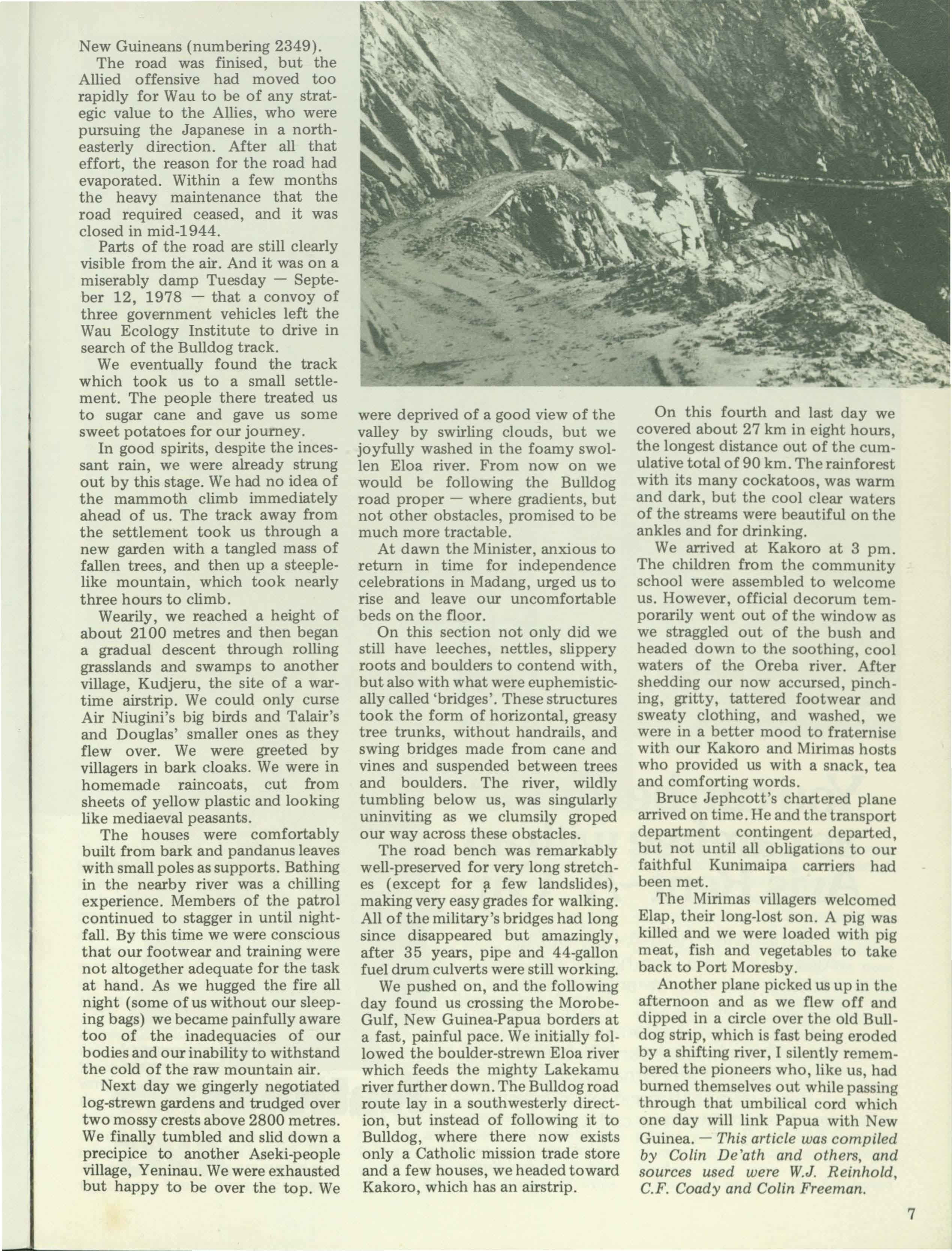
Parts of the road are still clearly visible from the air. And it was on a miserably damp Tuesday - Septeber 12, 1978 - that a convoy of three government vehicles left the Wau Ecology Institute to drive in search of the Bulldog track.
We eventually found the track which took us to a small settlement. The people there treated us to sugar cane and gave us some sweet potatoes for our journey.
In good spirits, despite the incessant rain, we were already strung out by this stage. We had no idea of the mammoth climb immediately ahead of us. The track away from the settlement took us through a new garden with a tangled mass of fallen trees, and then up a steeplelike mountain, which took nearly three hours to climb.
Wearily, we reached a height of about 2100 metres and then began a gradual descent through rolling grasslands and swamps to another village, Kudjeru, the site of a wartime airstrip. We could only curse Air Niugini's big birds and Talair's and Douglas' smaller ones as they flew over. We were greeted by villagers in bark cloaks. We were in homemade raincoats, cut from sheets of yellow plastic and looking like mediaeval peasants.
The houses were comfortably built from bark and pandanus leaves with small poles as supports. Bathing in the nearby river was a chilling experience. Members of the patrol continued to stagger in until nightfall. By this time we were conscious that our footwear and training were not altogether adequate for the task at hand. As we hugged the fire all night (some of us without our sleeping bags) we became painfully aware too of the inadequacies of our bodies and our inability to withstand the cold of the raw mountain air.
Next day we gingerly negotiated log-strewn gardens and trudged over two mossy crests above 2800 metres. We finally tumbled and slid down a precipice to another Aseki-people village, Yeninau. We were exhausted but happy to be over the top. We
were deprived of a good view of the valley by swirling clouds, but we joyfully washed in the foamy swollen Eloa river. From now on we would be following the Bulldog road proper - where gradients, but not other obstacles, promised to be much more tractable.
At dawn the Minister, anxious to return in time for independence celebrations in Madang, urged us to rise and leave our uncomfortable beds on the floor.
On this section not only did we still have leeches, nettles, slippery roots and boulders to contend with, but also with what were euphemistically called 'bridges'. These structures took the form of horizontal, greasy tree trunks, without handrails, and swing bridges made from cane and vines and suspended between trees and boulders. The river, wildly tumbling below us, was singularly uninviting as we clumsily groped our way across these obstacles.
The road bench was remarkably well-preserved for very long stretches ( except for p. few landslides), making very easy grades for walking. All of the military's bridges had long since disappeared but amazingly, after 35 years, pipe and 44-gallon fuel drum culverts were still working.
We pushed on, and the following day found us crossing the MorobeGulf, New Guinea-Papua borders at a fast, painful pace. We initially followed the boulder-strewn Eloa river which feeds the mighty Lakekamu river further down. The Bulldog road route lay in a southwesterly direction, but instead of following it to Bulldog, where there now exists only a Catholic mission trade store and a few houses, we headed toward Kakoro, which has an airstrip.
On this fourth and last day we covered about 27 km in eight hours, the longest distance out of the cumulative total of 90 km. The rainforest with its many cockatoos, was warm and dark, but the cool clear waters of the streams were beautiful on the ankles and for drinking.
We arrived at Kakoro at 3 pm. The children from the community school were assembled to welcome us. However, official decorum temporarily went out of the window as we straggled out of the bush and headed down to the soothing, cool waters of the Oreba river. After shedding our now accursed, pinching, gritty, tattered footwear and sweaty clothing, and washed, we were in a better mood to fraternise with our Kakoro and Mirimas hosts who provided us with a snack, tea and comforting words.
Bruce Jephcott's chartered plane arrived on time. He and the transport department contingent departed, but not until all obligations to our faithful Kunimaipa carriers had been met.
The Mirimas villagers welcomed Elap, their long-lost son. A pig was killed and we were loaded with pig meat, fish and vegetables to take back to Port Moresby.
Another plane picked us up in the afternoon and as we flew off and dipped in a circle over the old Bulldog strip, which is fast being eroded by a shifting river, I silently remembered the pioneers who, like us, had burned themselves out while passing through that umbilical cord which one day will link Papua with New Guinea. - This article was compiled by Colin De'ath and others, and sources used were W.J. Reinhold, C.F. Coady and Colin Freeman.
'Bootless', said Captain John Moresby when he sailed into an inlet a few kilometres east of Papua New Guinea's capital city named after him. In naval terminology, Captain Moresby had decided the inlet was 'useless' - good for nothing. Presumably the expression stems from the inadequacy of a seaman without his sea boots.
The name stuck - Bootless Bay it became and remains so to this day, a century later. But useless? Moresby was wrong. In the intervening years Bootless Bay has been the location of the country's first railway - along which was hauled copper ore from mines inland to smelters at the water's edge. The mines have long been exhausted and the railway hauled away for scrap.
But today Bootless Bay has a new activity, having been developed into a thriving recreational and educational centre.
Behind the activity are Ron and Lilian Prior. Getting away from Port Moresby for a weekend, they explored the Bootless Bay area, discovering some of the old railway tracks and following them down to the abandoned wharf. Captivated by the charm and atmosphere of the bay, the Priors acquired land and built a weekend hideaway.
At first that's all it was. But the lure of Bootless Bay grew stronger. One day they decided to abandon city life completely and moved to fulltime residence at their 'weekender'. They established the Tahira Boating Centre - 'home of little
[B[D(]][]1]@J~ IBffiW
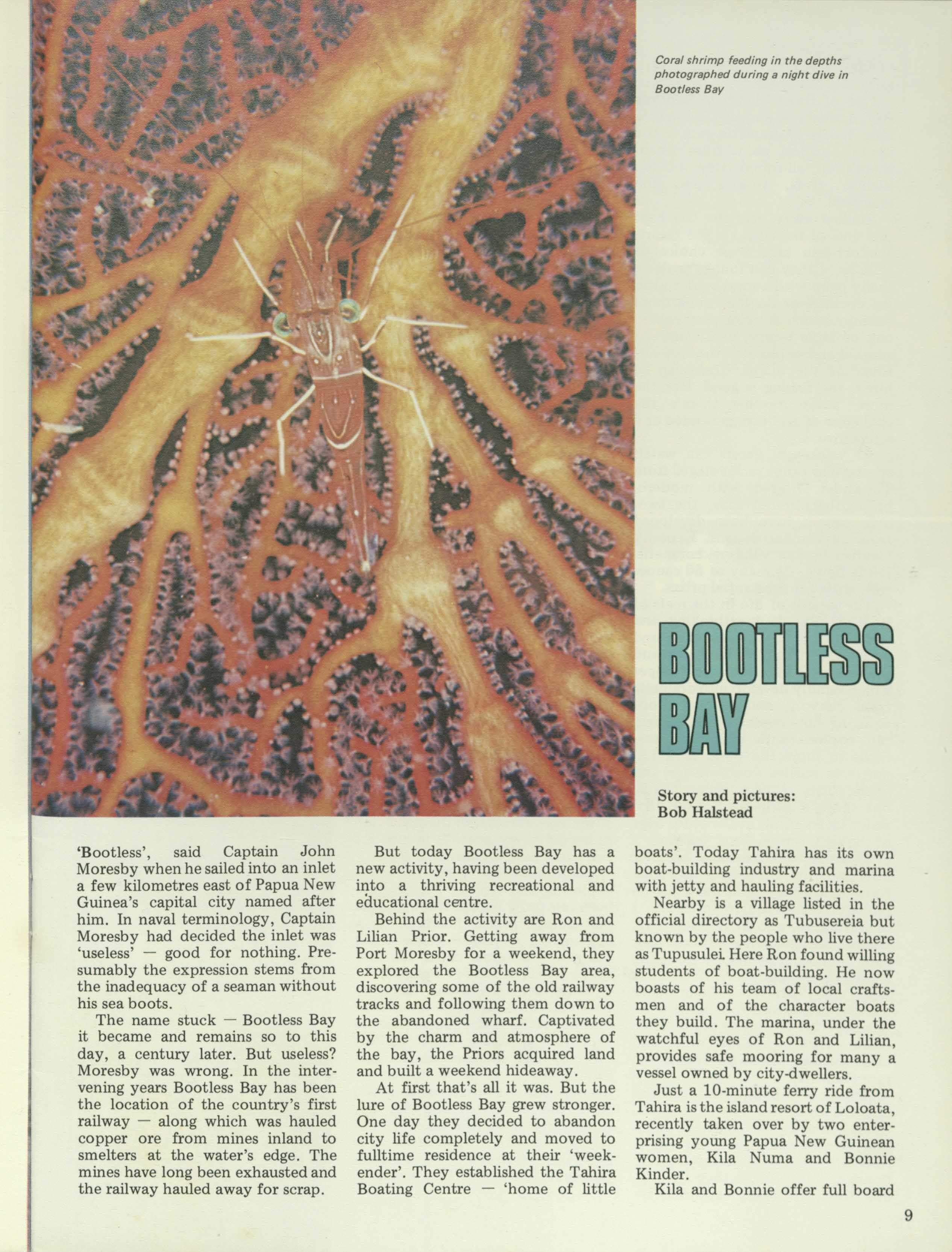
Story and pictures: Bob Halstead
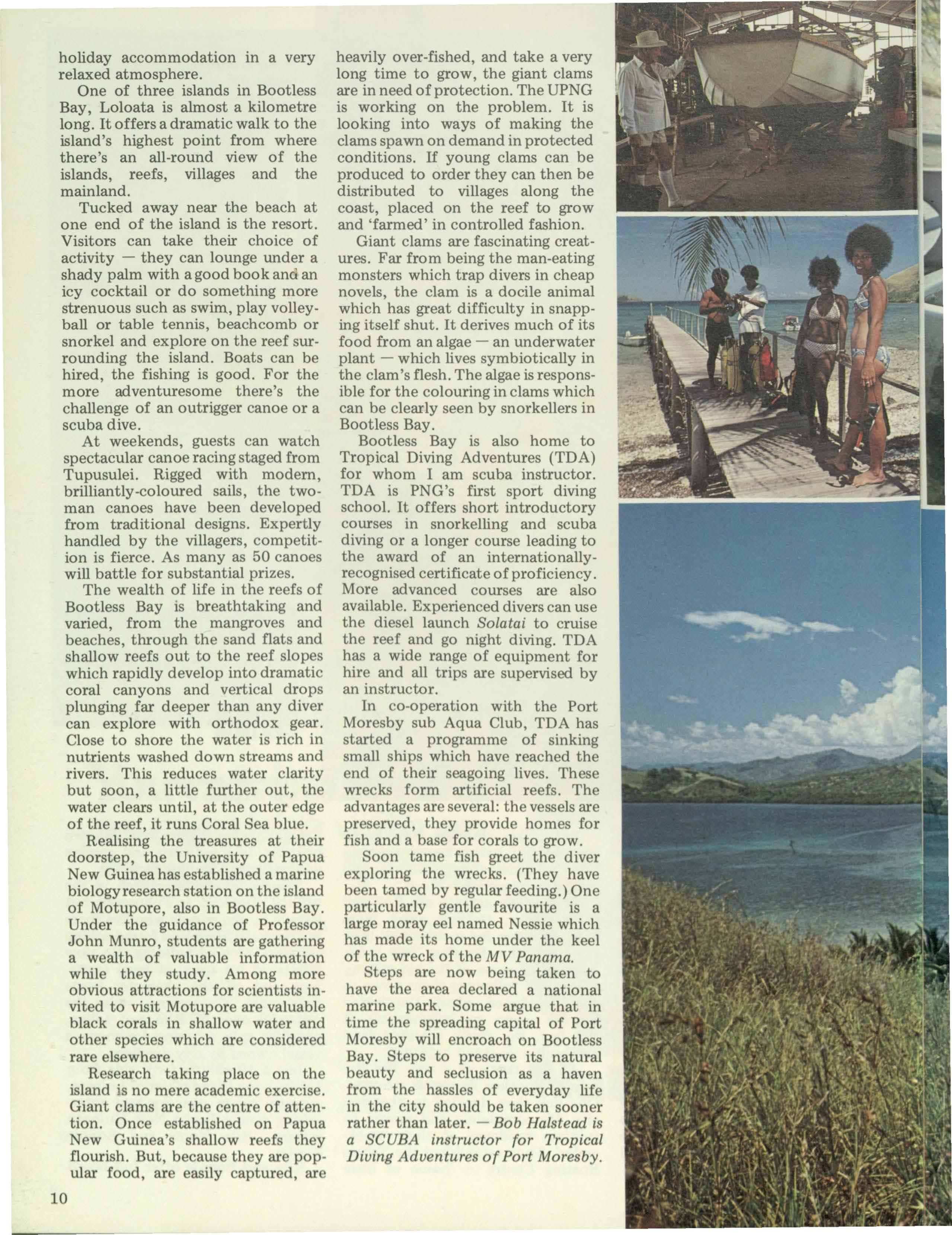
boats'. Today Tahira has its own boat-building industry and marina with jetty and hauling facilities.
Nearby is a village listed in the official directory as Tubusereia but known by the people who live there as Tupusulei. Here Ron found willing students of boat-building. He now boasts of his team of local craftsmen and of the character boats they build. The marina, under the watchful eyes of Ron and Lilian, provides safe mooring for many a vessel owned by city-dwellers.
Just a 10-minute ferry ride from Tahira is the island resort of Loloata, recently taken over by two enterprising young Papua New Guinean women, Kila Numa and Bonnie Kinder.
Kila and Bonnie offer full board
holiday accommodation in a very relaxed atmosphere.
One of three islands in Bootless Bay, Loloata is almost a kilometre long. It offers a dramatic walk to the island's highest point from where there's an all-round view of the islands, reefs, villages and the mainland.
Tucked away near the beach at one end of the island is the resort. Visitors can take their choice of activity - they can lounge under a shady palm with a good book an<ian icy cocktail or do something more strenuous such as swim, play volleyball or table tennis, beachcomb or snorkel and explore on the reef surrounding the island. Boats can be hired, the fishing is good. For the more adventuresome there's the challenge of an outrigger canoe or a scuba dive.
At weekends, guests can watch spectacular canoe racing staged from Tupusulei. Rigged with modern, brilliantly-coloured sails, the twoman canoes have been developed from traditional designs. Expertly handled by the villagers, competition is fierce. As many as 50 canoes will battle for substantial prizes.
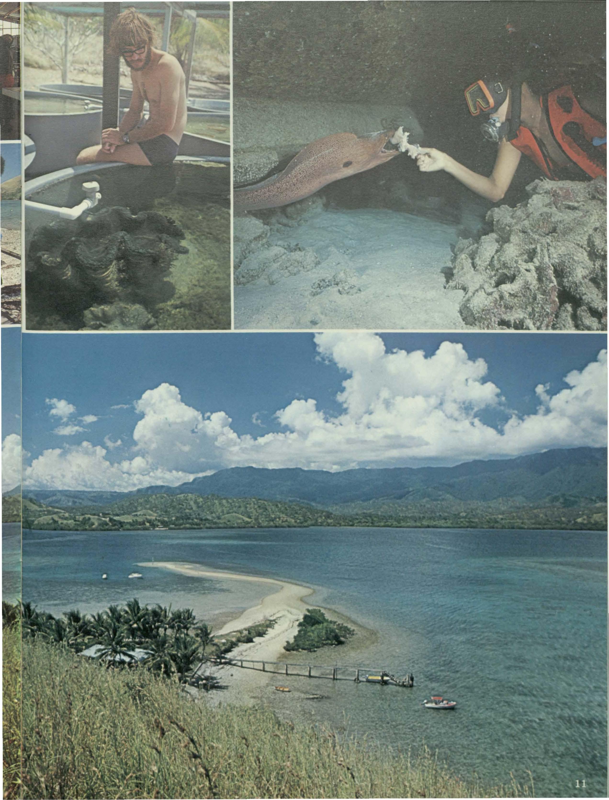
The wealth of life in the reefs of Bootless Bay is breathtaking and varied, from the mangroves and beaches, through the sand flats and shallow reefs out to the reef slopes which rapidly develop into dramatic coral canyons and vertical drops plunging far deeper than any diver can explore with orthodox gear. Close to shore the water is rich in nutrients washed down streams and rivers. This reduces water clarity but soon, a little further out, the water clears until, at the outer edge of the reef, it runs Coral Sea blue.
Realising the treasures at their doorstep, the University of Papua New Guinea has established a marine biology research station on the island of Motupore, also in Bootless Bay. Under the guidance of Professor John Munro, students are gathering a wealth of valuable information while they study. Among more obvious attractions for scientists invited to visit Motupore are valuable black corals in shallow water and other sp cies which are onsidered rare elsewhere.
Research taking plac on th island is no mer academic exercise. Giant clams ar the centr of attention. Once established on Papua New Guinea's shallow reefs they flourish. But, because they ar popular food, ar easily captur d, ar
heavily over-fished, and take a very long time to grow, the giant clams are in need of protection. The UPNG is working on the problem. It is looking into ways of making the clams spawn on demand in protected conditions. If young clams can be produced to order they can then be distributed to villages along the coast, placed on the reef to grow and 'farmed' in controlled fashion.
Giant clams are fascinating creatures. Far from being the man-eating monsters which trap divers in cheap novels, the clam is a docile animal which has great difficulty in snapping itself shut. It derives much of its food from an algae - an underwater plant - which lives symbiotically in the clam's flesh. The algae is responsible for the colouring in clams which can be clearly seen by snorkellers in Bootless Bay.
Bootless Bay is also home to Tropical Diving Adventures (TDA) for whom I am scuba instructor. TDA is PNG's first sport diving school. It offers short introductory courses in snorkelling and scuba diving or a longer course leading to the award of an internationallyrecognised certificate of proficiency. More advanced courses are also available. Experienced divers can use the diesel launch Solatai to cruise the reef and go night diving. TDA has a wide range of equipment for hire and all trips are supervised by an instructor.
In co-operation with the Port Moresby sub Aqua Club, TOA has started a programme of sinking small ships which have reached the end of their seagoing lives. These wrecks form artificial reefs. The advantages are several: the vessels are preserved, they provide homes for fish and a base for corals to grow.
Soon tame fish greet the diver exploring the wrecks. (They have been tamed by regular feeding.) One particularly gentle favourite is a large moray eel named Nessie which has made its home under the keel of the wreck of the MV Panama. teps ar now being taken to have the area declared a national marine park. Some argue that in time the spreading capital of Port Moresby will encroach on Bootless Bay. Steps to preserve its natural beauty and seclusion as a haven from the hassles of everyday life in the city should be taken sooner rather than later. - Bob Halstead is a SCUBA instructor for Tropical Diving Adventures of Port Moresby.
Cathay Pacific.Fromthe heart of Asia.
Cathay Pacific now flies every Sunday at 7.05 p.m. from Port Moresby to Hong Kong. From Hong Kong, Cathay Pacific flies North, South, East and West serving all the major cities in South-East Asia, Australia and the Middle East. On board you will be cared for by charming Oriental flight-hostesses specially chosen from the countries we serve and by highly experienced British and Australian pilots and flight engineers. Cathay Pacific. Direct from the heart of Asia to the heart of Papua New Guinea.
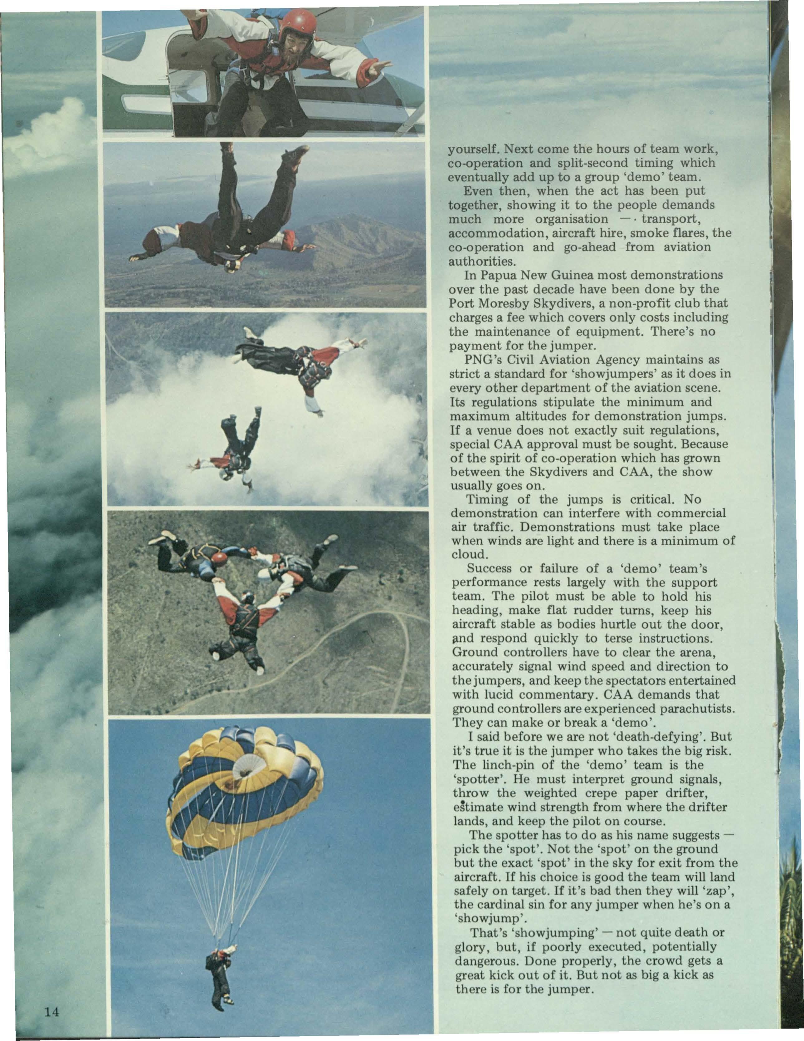
tell this one from the top down, eyes - and the words - of 'showoff Sadler.
'Fi ees left ... and again ... five left.'
The small Cessna jerks twice to the left. The thstruction, shouted from the open door, is barely audible above the roar of the wind and an engine straining for altitude. Behind the pilot, who is struggling to maintain heading, are five cramped bodies, muscles tense. They stare at the 'spotter' hanging out of the door, shouting orders.
Thoughts: Don't blow it now. Where did that drifter land? Where's that cloud going?
Hang on to your heading, pilot. Wow, there's a lot of people down there! And power lines. And goal posts. And Steamies' balloon.
A shout: 'Power off!' I light my flare. Out I go. The whine above me fades. Below the crowd watches. I'm a dark dot streaming orange smoke, falling away from the Cessna. Behind me appears another dot. And another. Then! A triple explosion of colour and sound.
Our parachutes burst open. From 190 kilometres an hour descent we are snatched to a comparative standstill. We're flying at 600 metres.
Thoughts: Where's that wind indicator?
Watch those trees. Power lines. Keep away from the balloon. Two hundred metres. Okay. Turn her in. On final approach. Watch the overshoot. Left a little. Brake now. Ouch. The ground's.hard. On your feet quickly. The crowd sounds great. They 're enjoying it. No zaps. We've done it well.
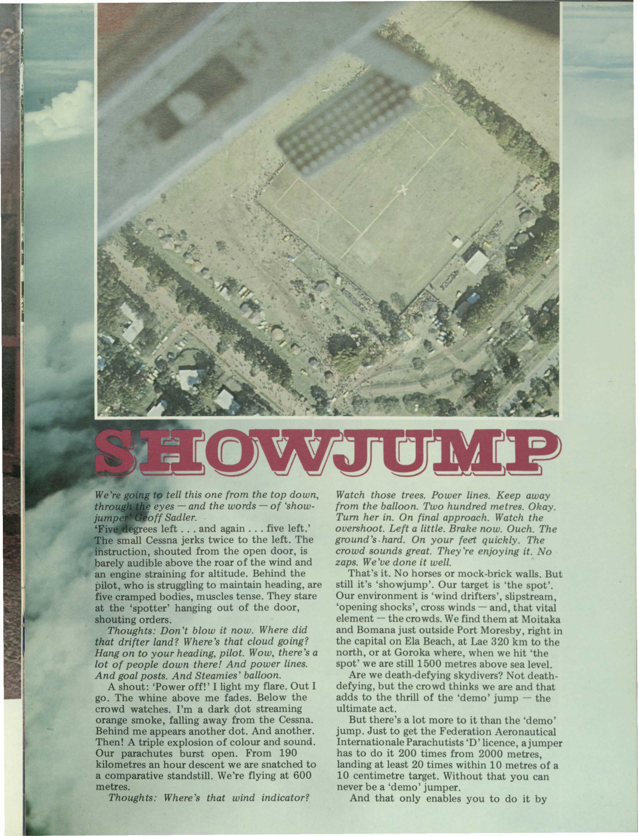
That's it. No horses or mock-brick walls. But still it's 'showjump'. Our target is 'the spot'. Our environment is 'wind drifters', slipstream, 'opening shocks', cross winds - and, that vital element - the crowds. We find them at Moitaka and Bomana just outside Port Moresby, right in the capital on Ela Beach, at Lae 320 km to the north, or at Goroka where when we hit 'th spot' we are still 1500 metres above sea level.
Are we death-defying skydivers? ot deathdefying, but the crowd thinks we are and that adds to the thrill of the 'demo' jump - the ultimate act.
But there's a lot more to it than the 'demo' jump. Just to get the Federation Aeronautical Internationale Parachutists 'D' licence, a jumper has to do it 200 times from 2000 metres, landing at least 20 times within 10 metres of a 10 centimetre target. Without that you can never be a demo' jumper.
And that only enables you to do it by
yourself. Next come the hours of team work, co-operation and split-second timing which eventually add up to a group 'demo' team.
Even then, when the act has been put together, showing it to the people demands much more organisation - • transport, accommodation, aircraft hire, smoke flares, the co-operation and go-ahead from aviation authorities.
In Papua New Guinea most demonstrations over the past decade have been done by the Port Moresby Skydivers, a non-profit club that charges a fee which covers only costs including the maintenance of equipment. There's no payment for the jumper.
PNG's Civil Aviation Agency maintains as strict a standard for 'showjumpers' as it does in every other department of the aviation scene. Its regulations stipulate the minimum and maximum altitudes for demonstration jumps. If a venue does not exactly suit regulations, special CAA approval must be sought. Because of the spirit of co-operation which has grown between the Skydivers and CAA, the show usually goes on.
Timing of the jumps is critical. No demonstration can interfere with commercial air traffic. Demonstrations must take place when winds are light and there is a minimum of cloud.
Success or failure of a 'demo' team's performance rests largely with the support team. The pilot must be able to hold his heading, make flat rudder turns, keep his aircraft stable as bodies hurtle out the door, i3,nd respond quickly to terse instructions. Ground controllers have to clear the arena, accurately signal wind speed and direction to the jumpers, and keep the spectators entertained with lucid commentary. CAA demands that ground controllers are experienced parachutists. They can make or break a 'demo'.
I said before we are not 'death-defying'. But it's true it is the jumper who takes the big risk. The linch-pin of the 'demo' team is the 'spotter'. He must interpret ground signals, throw the weighted crepe paper drifter, e~timate wind strength from where the drifter lands, and keep the pilot on course.
The spotter has to do as his name suggestspick the 'spot'. Not the 'spot' on the ground but the exact 'spot' in the sky for exit from the aircraft. If his choice is good the team will land safely on target. If it's bad then they will 'zap', the cardinal sin for any jumper when he's on a 'showjump'.
That's 'showjumping' - not quite death or glory, but, if poorly executed, potentially dangerous. Done properly, the crowd gets a great kick out of it. But not as big a kick as there is for the jumper.
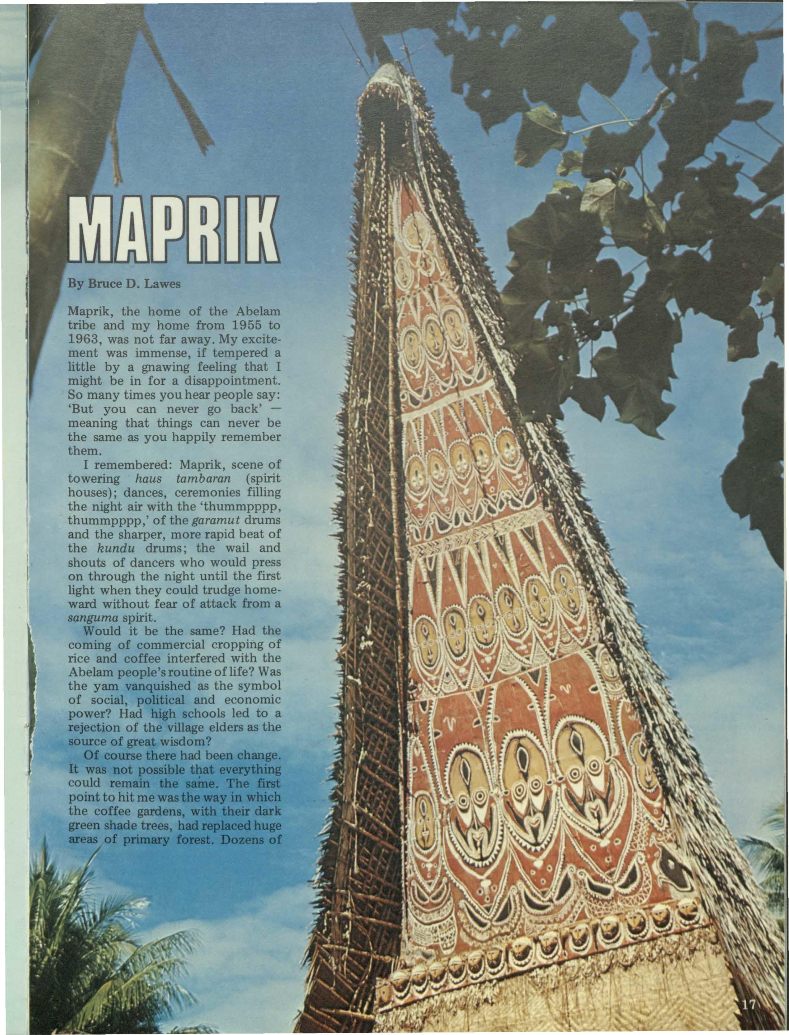
By Bruce D. Lawes
Maprik, the home of the Abelam tribe and my home from 1955 to 1963, was not far away. My excitement was immense, if tempered a little by a gnawing feeling that I might be in for a disappointment. So many times you hear people say: 'But you can never go back'meaning that things can never be the same as you happily remember them.
I remembered: Maprik, scene of towering haus tambaran (spirit houses); dances, ceremonies filling the night air with the 'thummpppp, thummpppp,' of the garamut drums and the sharper, more rapid beat of the kundu drums; the wail and shouts of dancers who would press on through the night until the first light when they could trudge homeward without fear of attack from a sanguma spirit.
Would it be the same? Had the coming of commercial cropping of rice and coffee interfered with the Abelam people's routine oflife? Was the yam vanquished as the symbol of social, political and economic power? Had high schools led to a rejection of the village elders as the source of great wisdom?
Of course there had been change. It was not possible that everything could remain the saine. The first point to hit me was the way in which the coffee gardens, with their dark green shade trees, had replaced huge areas of primary forest. Dozens of
children, greatly outnumbering mature adults, spoke loudly of the success of the health programme; of how malaria, tuberculosis, yaws and many post-natal problems had been brought under control.
Where I had trudged on foot, along slippery tracks, too steep and narrow for even a World War Two Jeep, I now sped along on gravel roads in a rented Corolla wagon. I covered in half an hour what had been a full day's sweaty toil little more than a decade previously.
But during my three-week stay in the ar a I found much to reinforce my opinion that Maprik is still the most exciting area in Papua New Guin_ea. Many colourful ceremonies and customs are still intact
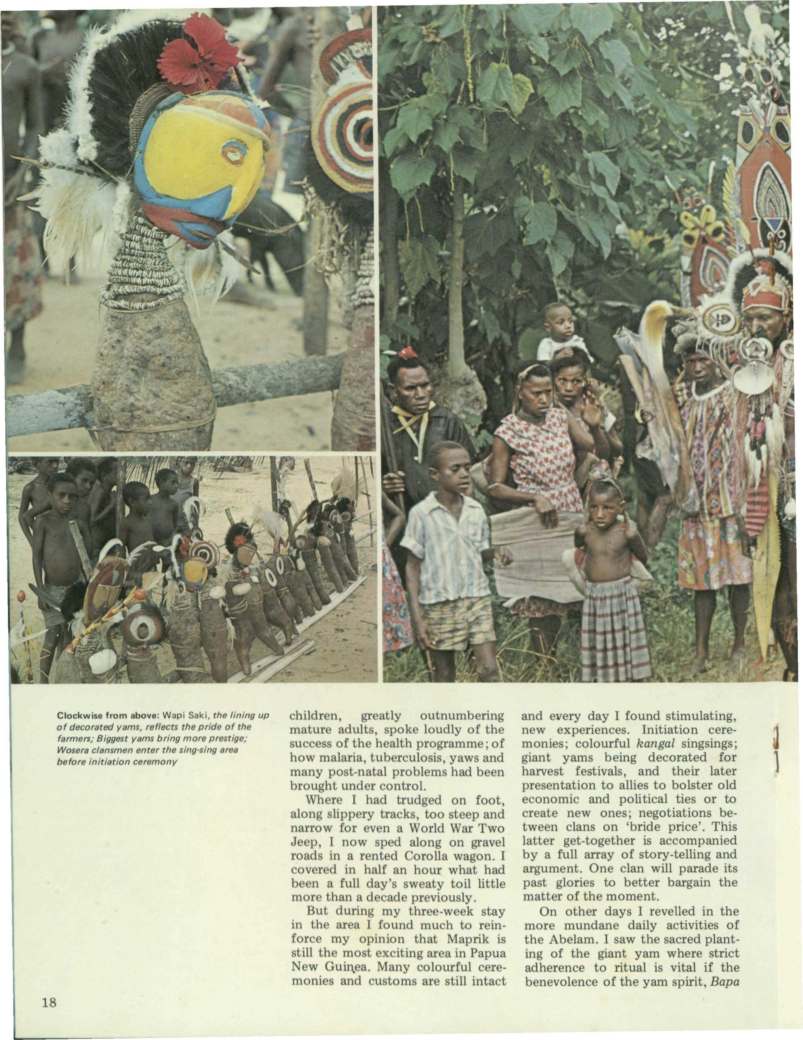
and every day I found stimulating, new experiences. Initiation ceremonies; colourful kangal singsings; giant yams being decorated for harvest festivals, and their later presentation to allies to bolster old economic and political ties or to create new ones; negotiations between clans on 'bride price'. This latter get-together is accompanied by a full array of story-telling and argument. One clan will parade its past glories to better bargain the matter of the moment.
On other days I revelled in the more mundane daily activities of the Abelam. I saw the sacred planting of the giant yam where strict adherence to ritual is vital if the benevolence of the yam spirit, Bapa
Clockwise from above: Wapi Saki, the lining up of decorated yams, reflects the pride of the farmers; Biggest yams bring more prestige; Wosere clansmen enter the sing-sing area before initiation ceremony
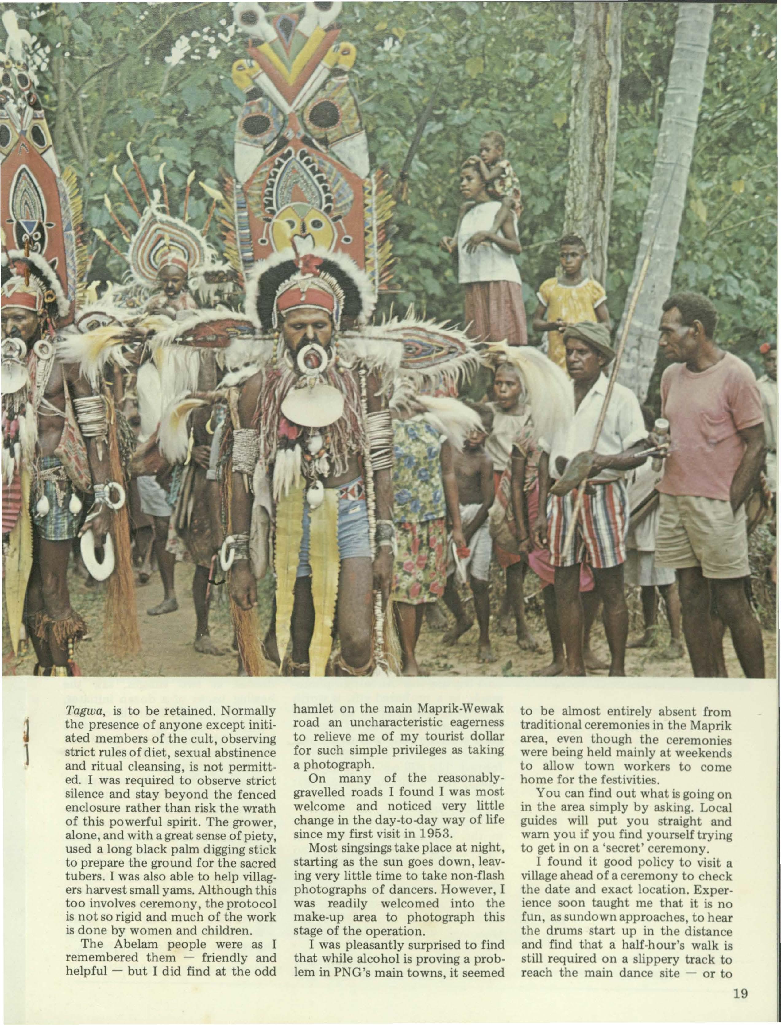
Tagwa, is to be retained. Normally the presence of anyone except initiated members of the cult, observing strict rules of diet, sexual abstinence and ritual cleansing, is not permitted. I was required to observe strict silence and stay beyond the fenced enclosure rather than risk the wrath of this powerful spirit. The grower, alone, and with a great sense of piety, used a long black palm digging stick to prepare the ground for the sacred tubers. I was also able to help villagers harvest small yams. Although this too involves ceremony, the protocol is not so rigid and much of the work is done by women and children.
The Abelam people were as I remembered them - friendly and helpful - but I did find at the odd
hamlet on the main Maprik-Wewak road an uncharacteristic eagerness to relieve me of my tourist dollar for such simple privileges as taking a photograph.
On many of the reasonablygravelled roads I found I was most welcome and noticed very little change in the day-to-day way of life since my first visit in 1953.
Most singsings take place at night, starting as the sun goes down, leaving very little time to take non-flash photographs of dancers. However, I was readily welcomed into the make-up area to photograph this stage of the operation.
I was pleasantly surprised to find that while alcohol is proving a problem in PNG's main towns, it seemed
to be almost entirely absent from traditional ceremonies in the Maprik area, even though the ceremonies were being held mainly at weekends to allow town workers to come home for the festivities.
You can find out what is going on in the area simply by asking. Local guides will put you straight and warn you if you find yourself trying to get in on a 'secret' ceremony.
I found it good policy to visit a village ahead of a ceremony to check the date and exact location. Experience soon taught me that it is no fun, as sundown approaches, to hear the drums start up in the distance and find that a half-hour's walk is still required on a slippery track to reach the main dance site - or to
find out that the main event had been held days before.
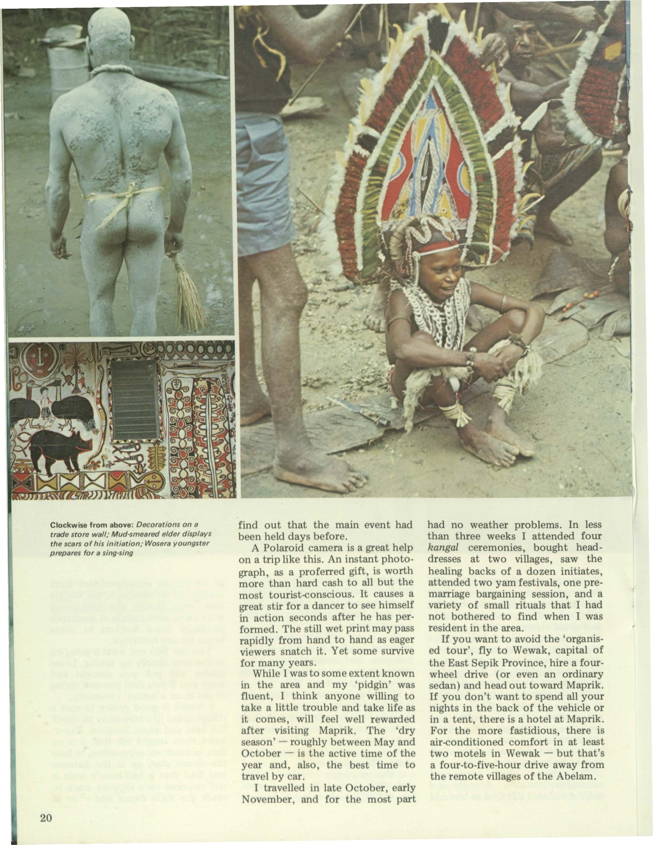
A Polaroid camera is a great help on a trip like this. An instant photograph, as a proferred gift, is worth more than hard cash to all but the most tourist-conscious. It causes a great stir for a dancer to see himself in action seconds after he has performed. The still wet print may pass rapidly from hand to hand as eager viewers snatch it. Yet some survive for many years.
While I was to some extent known in the area and my 'pidgin' was fluent, I think anyone willing to take a little trouble and take life as it comes, will feel well rewarded after visiting Maprik. The 'dry season' - roughly between May and October - is the active time of the year and, also, the best time to travel by car.
I travelled in late October, early November, and for the most part
had no weather problems. In less than three weeks I attended four kangal ceremonies, bought headdresses at two villages, saw the healing backs of a dozen initiates, attended two yam festivals, one premarriage bargaining session, and a variety of small rituals that I had not bothered to find when I was resident in the area.
If you want to avoid the 'organised tour', fly to Wewak, capital of the East Sepik Province, hire a fourwheel drive ( or even an ordinary sedan) and head out toward Maprik. If you don't want to spend all your nights in the back of the vehicle or in a tent, there is a hotel at Maprik. For the more fastidious, there is air-conditioned comfort in at least two motels in Wewak - but that's a four-to-five-hour drive away from the remote villages of the Abelam.
Clockwise from above: Decorations on a trade store wall; Mud-smeared elder displays the scars of his initiation; Wosara youngster prepares for a sing-sing
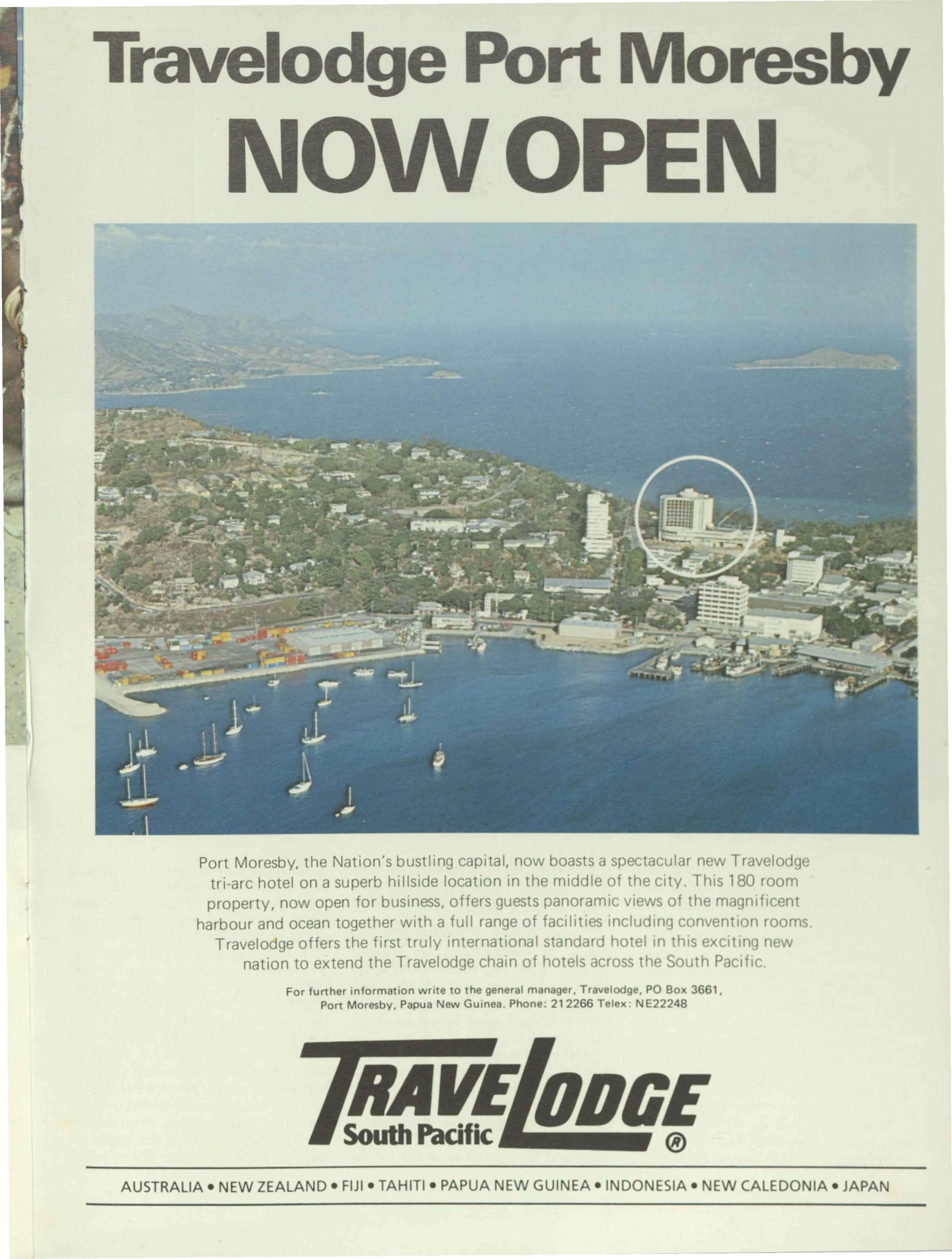
Travelodge Port Moresby NOWOPEN
Port Moresby, the Nation's bustling capital, now boasts a spectacular new Travelodge tri-arc hotel on a superb hillside location in the middle of the city. This 180 room property, now open for business, offers guests panoramic views of the magnificent harbour and ocean together with a full range of facilities including convention rooms. Travelodge offers the first truly international standard hotel in this exciting new nation to extend the Travelodge chain of hotels across the South Pacific.
For further information write to the general manager, Travelodge, PO Box 3661, Port Moresby, Papua New Guinea. Phone: 212266 Telex: NE22248
z
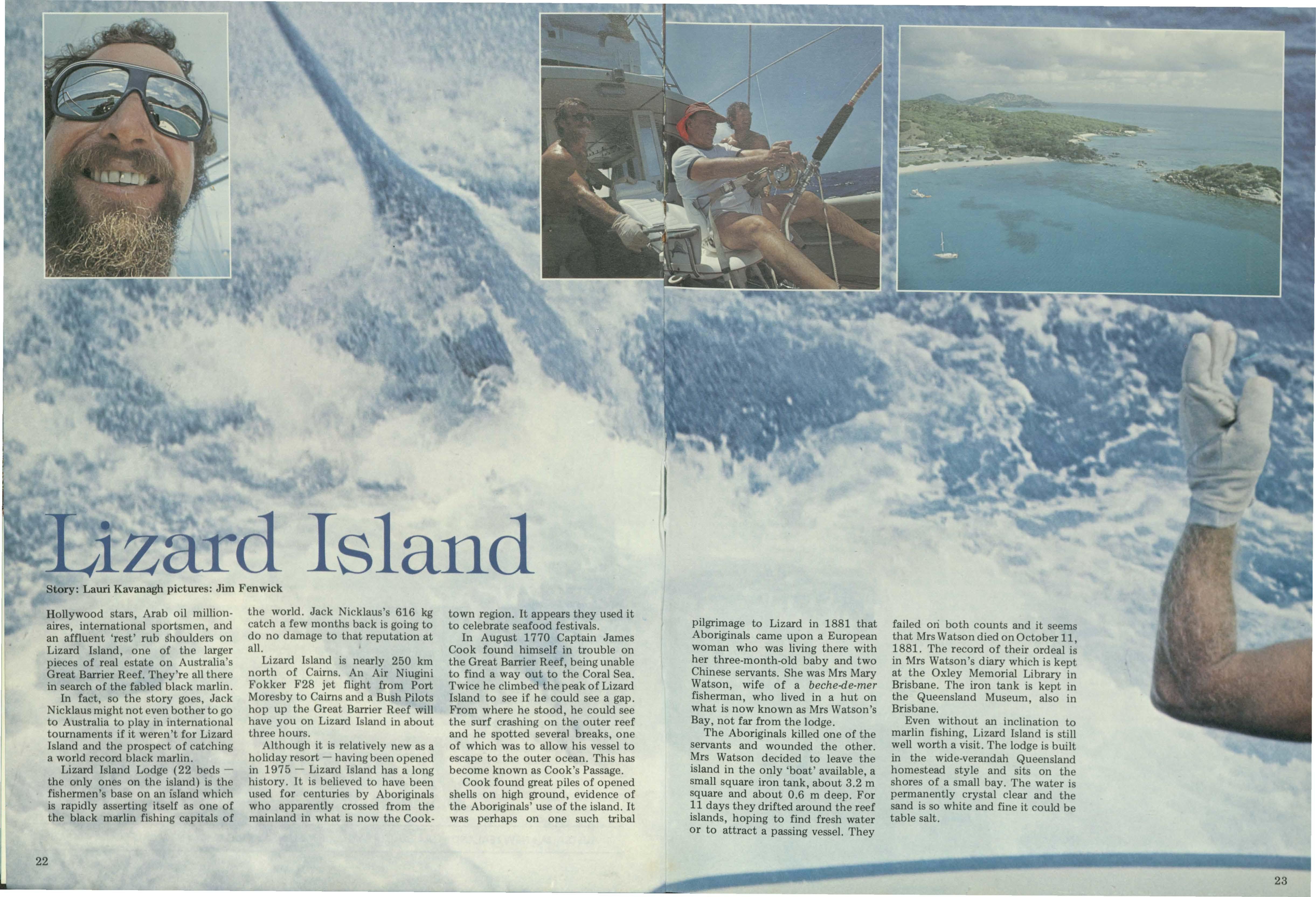
d Island
Story: Lauri Kavanagh pictures: Jim Fenwick
Hollywood stars, Arab oil millionaires, international sportsmen, and an affluent 'rest' rub shoulders on Lizard Island, one of the larger pieces of real estate on Australia's Great Barrier Reef. They're all there in search of the fabled black marlin. In fact, so the story goes, Jack Nicklaus might not even bother to go to Australia to play in international tournaments if it weren't for Lizard Island and the prosp et of catching a world record black marlin.
Lizard Island Lodge (22 b dsthe only ones on th island) is the fishermen's base on an island which is rapidly asserting itself as on of the black marlin fishing capitals of
the world. Jack Nicklaus's 616 kg catch a few months back is going to do no damage to that reputation at all.
Lizard Island is nearly 250 km north of Cairns. An Air Niugini Fokker F28 jet flight from Port Moresby to Cairns and a Bush Pilots hop up the Great Barrier Reef will have you on Lizard Island in about three hours.
Although it is relatively new as a holiday resort - having been opened in 197 5 Lizard Island has a long history. It is believed to have been us d for centuries by Aboriginals who apparently crossed from the mainland in what is now the Cook-
town region. It appears they used it to celebrate seafood festivals.
In August 1 770 Captain James Cook found himself in trouble on the Great Barrier Reef, being unable to find a way out to the Coral Sea. Twice he climbed the peak of Lizard Island to see if he could see a gap. From where he stood, he could see the surf crashing on the outer reef and he spotted several breaks, one of which was to allow his vessel to escape to the outer ocean. This has become known as Cook's Passage. Cook found great piles of opened shells on high ground, evidence of the Aboriginals' use of the island. It was perhaps on one such tribal
pilgrimage to Lizard in 1881 that Aboriginals came upon a European woman who was living there with her three-month-old baby and two Chinese servants. She was Mrs Mary Watson, wife of a beche-de-mer fisherman, who lived in a hut on what is now known as Mrs Watson's Bay, not far from the lodge.
The Aboriginals killed one of the servants and wounded the other. Mrs Watson decided to leave the island in the only 'boat' available, a small square iron tank, about 3.2 m square and about 0.6 m deep. For 11 days they drifted around the reef islands, hoping to find fresh water or to attract a passing vessel. They
failed ori both counts and it seems that Mrs Watson died on October 11 1881. The record of their ordeal i~ in Mrs Watson's diary which is kept at the Oxley Memorial Library in Brisbane. The iron tank is kept in the Queensland Museum, also in Brisbane.
Even without an inclination to marlin fishing, Lizard Island is still well worth a visit. The lodge is built in the wide-verandah Queensland homestead style and sits on the shores of a small bay. The water is permanently crystal clear and the sand is so white and fine it could be table salt.
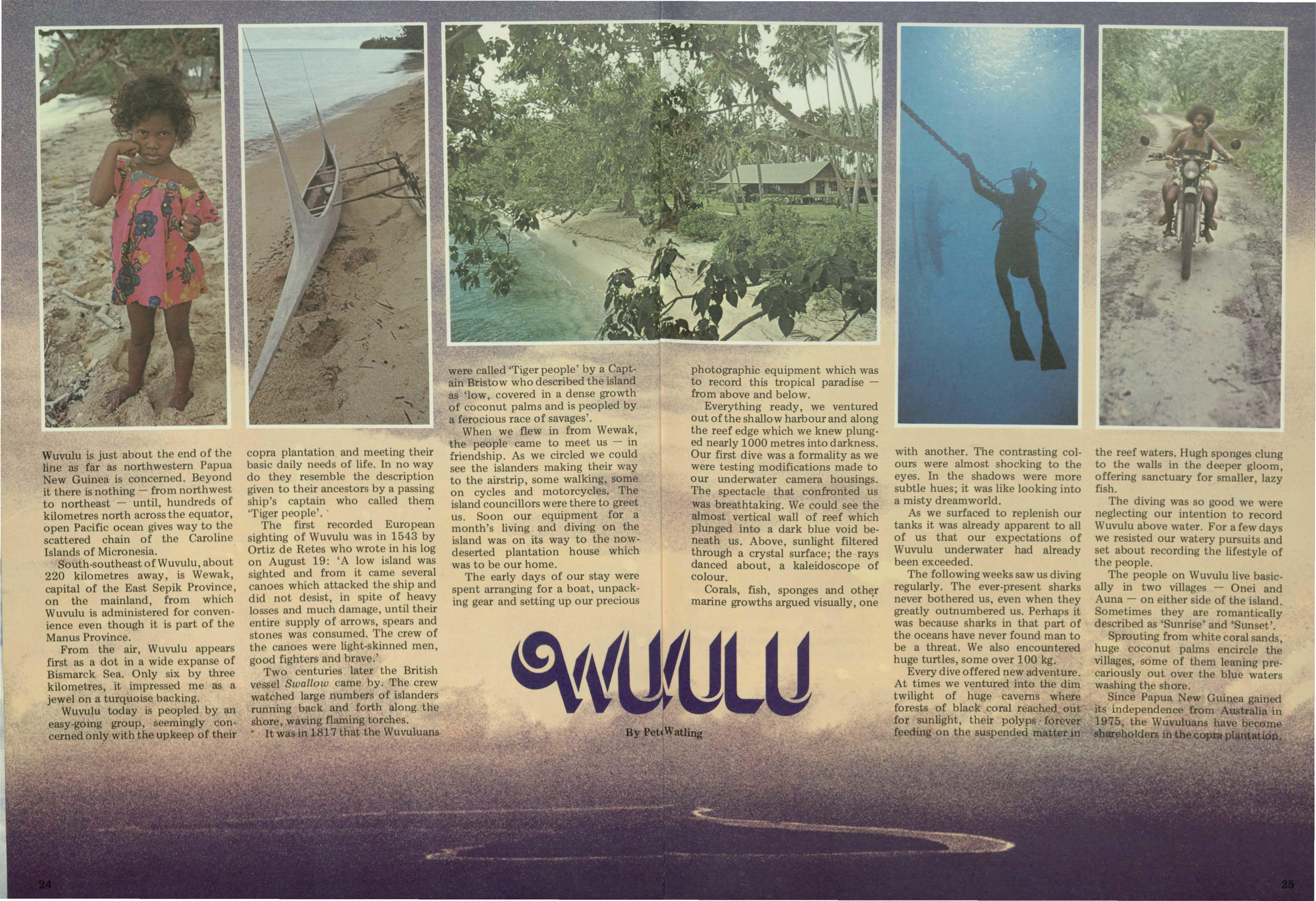
Wuvulu is just about the end of the line as far as northwestern Papua New Guinea is concerned. Beyond it there is nothing - from north west to northeast - until, hundreds of kilometres north across the equator, open Pacific ocean gives way to ~he scattered chain of the Carolme Islands of Micronesia.
South-southeast of Wuvulu, about 220 kilometres away, is Wewak, capital of the East Sepik Province, on the mainland, from which Wuvulu is administered for convenience even though it is part of the Manus Province.
From the air, Wuvulu appears first as a dot in a wide expanse of Bismarck Sea. Only six by three kilometres, it impressed me as a jewel on a turquoise backing.
Wuvulu today is peopled by an easy-going group, seemingly concerned only with the upke p of their
copra plantation and meeting their basic daily needs of life. In no way do they resemble the description given to their ancestors by a passing ship's captain who called them 'Tiger people'. • •
The first recorded European sighting of Wuvulu was in 1543 by Ortiz de Retes who wrote in his log on August 19: 'A low island was sighted and from it came several canoes which attacked the ship and did not desist, in spite of heavy losses and much damage, until their entire supply of arrows, spears and stones was consumed. The crew of the canoes were light-skinned men, good fight r and brave.'
Two centuries later the British vessel Swallow ame by. The crew watched large numbers of islanders running back and forth along the shore, waving flaming torches.
• It was in 1817 that the Wuvuluans
were called 'Tiger people' by a Captain Bristow who described the island as 'low, covered in a dense growth of coconut palms and is peopled by a ferocious race of savages'.
When we flew in from Wewak, the people came to meet us - in friendship. As we circled we could see the islanders making their way to the airstrip, some walking, some on cycles and motorcycles. The island councillors were there to greet us. Soon our equipment for a month's living and diving on the island was on its way to the nowdeserted plantation house which was to be our home.
The early days of our stay were spent arranging for a boat, unpacking gear and setting up our precious
photographic equipment which was to record this tropical paradisefrom above and below.
Everything ready, we ventured out of the shallow harbour and along the reef edge which we knew plunged nearly 1000 metres into darkness. Our first dive was a formality as we were testing modifications made to our underwater camera housings. The spectacle that confronted us was breathtaking. We could see the almost vertical wall of reef which plunged into a dark blue void beneath us. Above, sunlight filtered through a crystal surface; the rays danced about, a kaleidoscope of colour.
Corals, fish, sponges and oth~r marine growths argued visually, one
with another. The contrasting colours were almost shocking to the eyes. In the shadows were more subtle hues; it was like looking into a misty dreamworld.
As we surfaced to replenish our tanks it was already apparent to all of us that our expectations of Wuvulu underwater had already been exceeded.
The following weeks saw us diving regularly. The ever-present sharks never bothered us, even when they greatly outnumbered us. Perhaps it was because sharks in that part of the oceans have never found man to be a threat. We also encountered huge turtles, some over 100 kg.
Every dive offered new adventure. At times we ventured into the dim twilight of huge caverns where forests of black coral reached out for sunlight, their polyps • forever feeding on the suspended matter in
the reef waters. Hugh sponges clung to the walls in the deeper gloom, offering sanctuary for smaller, lazy fish.
The diving was so good we were neglecting our intention to record Wuvulu above water. For afewdays we resisted our watery pursuits and set about recording the lifestyle of the people.
The people on Wuvulu live basically in two villages - Onei and Auna - on either sid of the island. Sometimes they are romantically described as 'Sunrise' and ' unset'.
Sprouting from white coral sands huge coconut palms encircle th~ villages, some of them l aning prcariously out over the blu wat rs washing the shore.
Since Papua ew Guinea gained its independence from Australia in 1975, the Wuvuluan have o corn sb holders ·nthe~op p at30 .
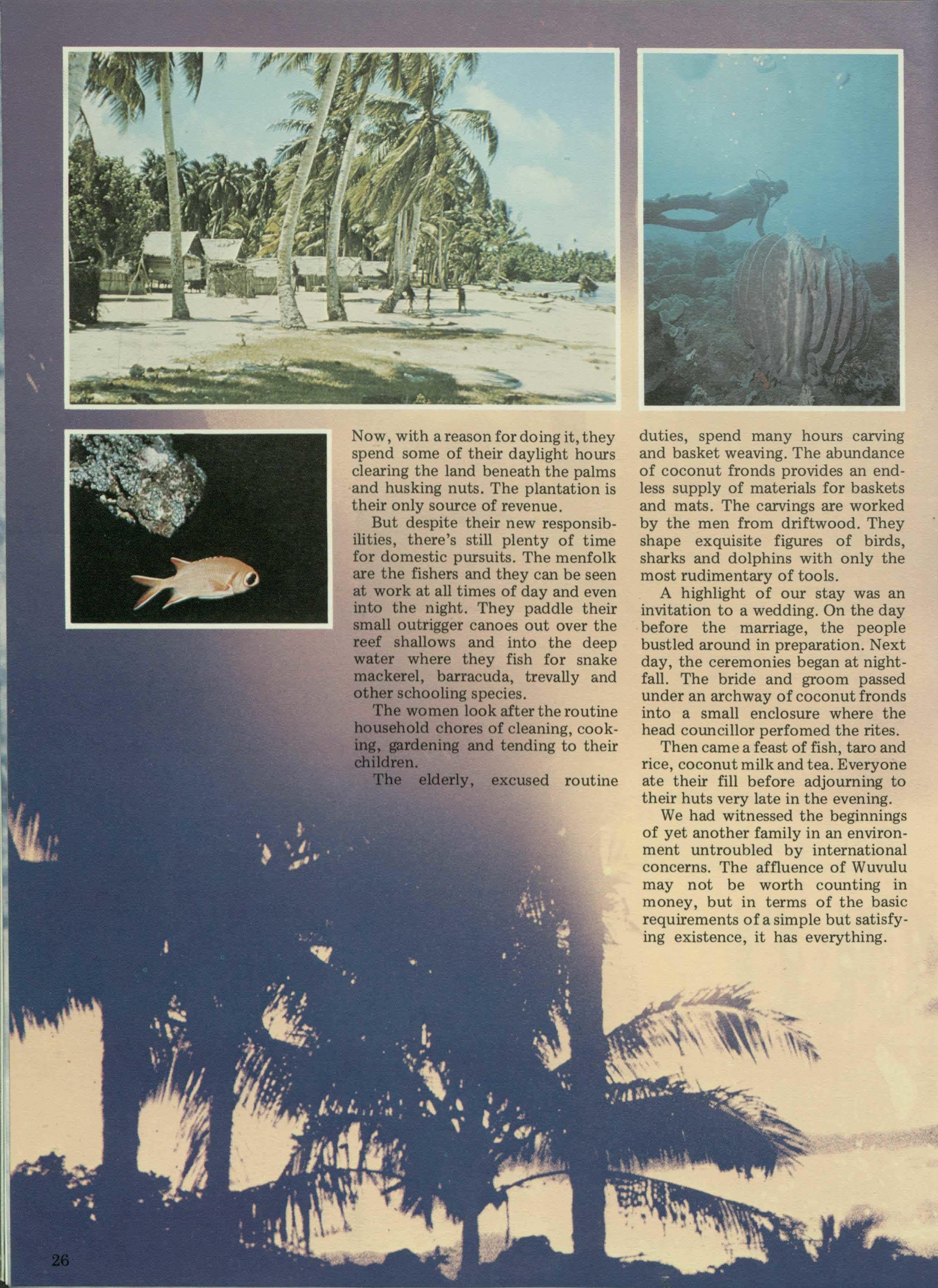
Now, with areasonfordoingit, they spend some of their daylight hours clearing the land beneath the palms and husking nuts. The plantation is their only source of revenue.
But despite their new responsibilities, there's still plenty of time for domestic pursuits. The menfolk are the fishers and they can be seen at work at all times of day and even into the night. They paddle their small outrigger canoes out over the reef shallows and ihto the deep water where they fish for snake mackerel, barracuda, trevally and other schooling species.
The women look after the routine household chores of cleaning, cooking, gardening and tending to their children.
The elderly, excused routine
duties, spend many hours carving and basket weaving. The abundance of coconut fronds provides an endless supply of materials for baskets and mats. The carvings are worked by the men from driftwood. They shape exquisite figures of birds, sharks and dolphins with only the most rudimentary of tools.
A highlight of our stay was an invitation to a wedding. On the day before the marriage, the people bustled around in preparation. Next day, the ceremonies began at nightfall. The bride and groom passed under an archway of coconut fronds into a small enclosure where the head councillor perfomed the rites. Then came a feast of fish, taro and rice, coconut milk and tea. Everyone ate their fill before adjourning to their huts very late in the evening. We had witnessed the beginnings of yet another family in an environment untroubled by international concerns. The affluence of Wuvulu may not be worth counting in money, but in terms of the basic requirements of a simple but satisfying existence, it has everything.
It's the book readers asked us to publish. Best of Paradiseis a selection of stories and pictures from early issues of Paradise magazine. It's on sale now at leading book-stores in Papua New Guinea for just K6.95. Or you can order your copy by mail, from Robert Brown and Associates, PO Box 3395, Port Moresby, Papua New Guinea ( add K1.00 for postage).
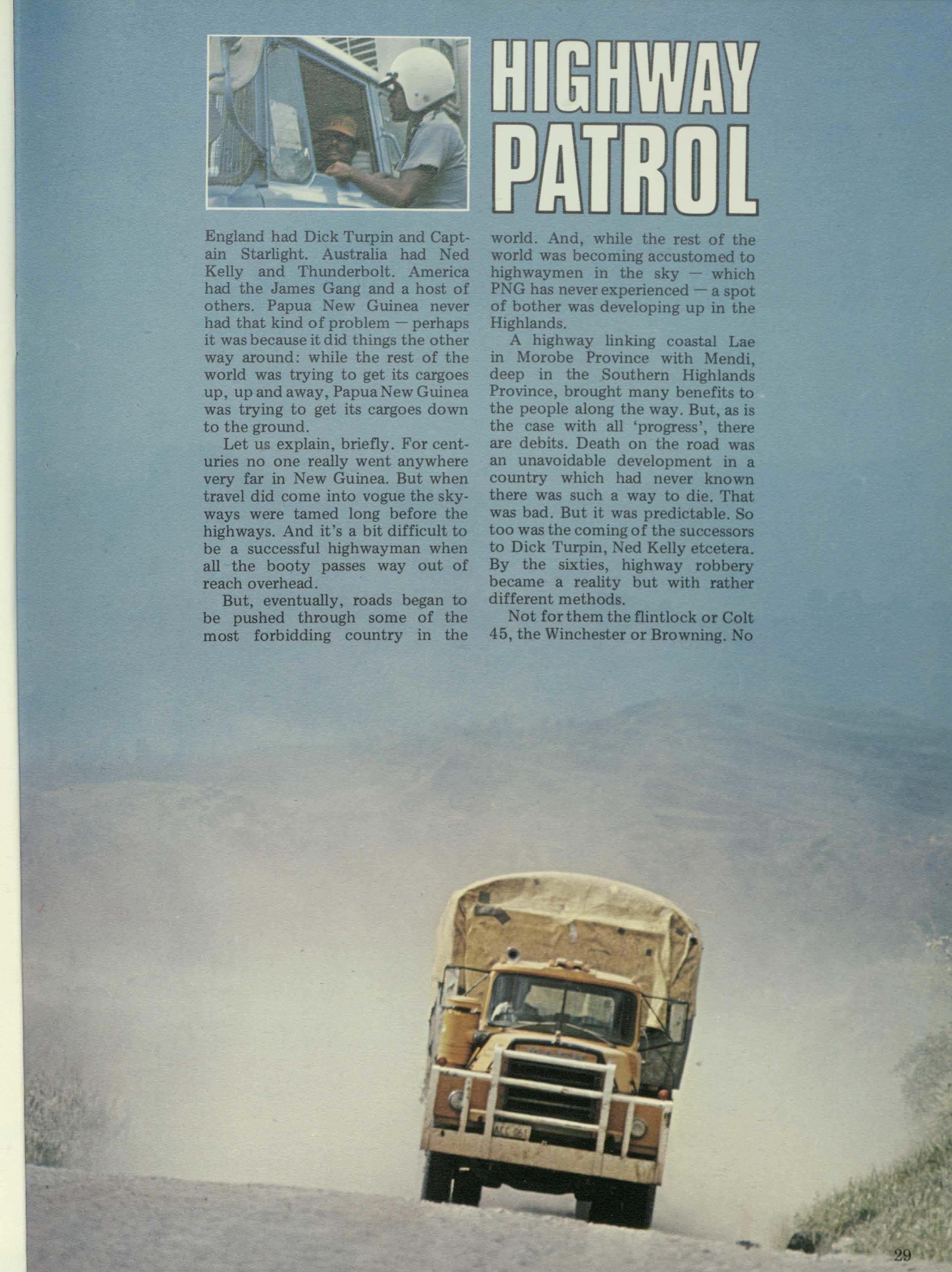
England had Dick Turpin and Captain Starlight. Australia had Ned Kelly and Thunderbolt. America had the James Gang and a host of others. Papua New Guinea never had that kind of problem - perhaps it was because it did things the other way around; while the rest of the world was trying to get its cargoes up, up and away, PapuaNewGuinea was trying to get its cargoes down to the ground.
Let us explain, briefly. For centuries no one really went anywhere very far in New Guinea. But when travel did come into vogue the skyways were tamed long before the highways. And it's a bit difficult to be a successful highwayman when all the booty passes way out of reach overhead.
But, eventually, roads began to be pushed through some of the most forbidding country in the
world. And, while the rest of the world was becoming accustomed to highwaymen in the sky - which PNG has never experienced - a spot of bother was developing up in the Highlands.
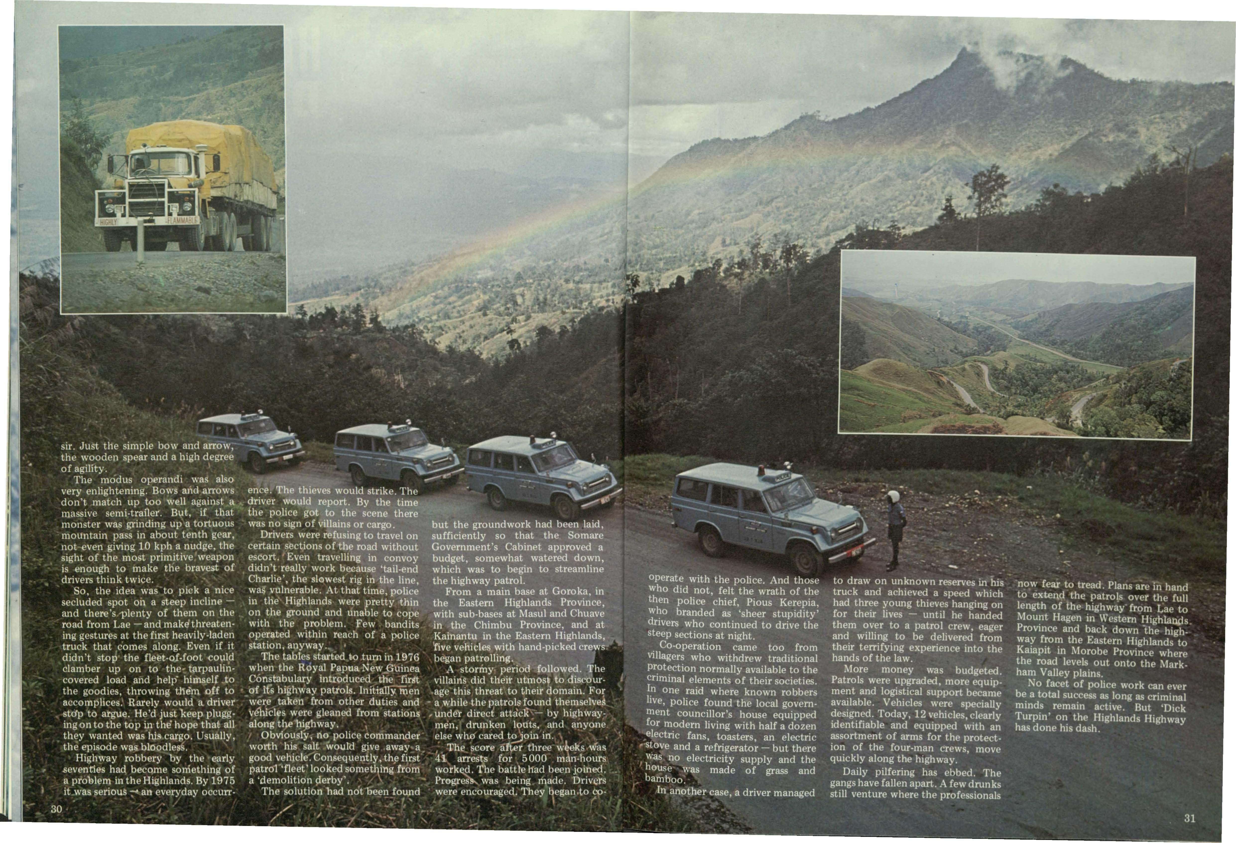
A highway linking coastal Lae in Morobe Province with Mendi, deep in the Southern Highlands Province, brought many benefits to the people along the way. But, as is the case with all 'progress', there are debits. Death on the road was an unavoidable development in a country which had never known there was such a way to die. That was bad. But it was predictable. So too was the coming of the successors to Dick Turpin, Ned Kelly etcetera. By the sixties, highway robbery became a reality but with rather different methods.
Not for them the flintlock or Colt 45, the Winchester or Browning. No
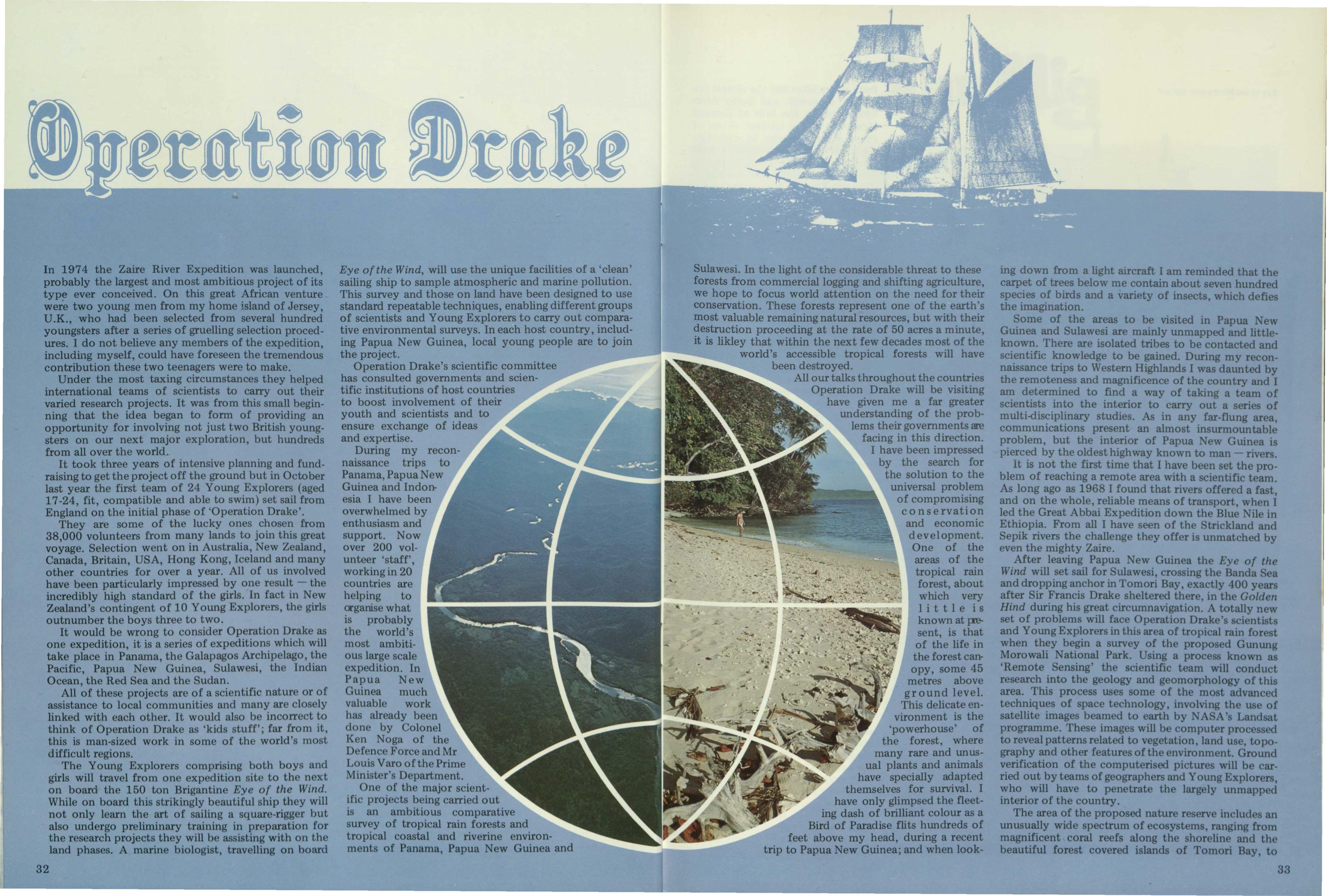
In 1974 the Zaire River Expedition was launched, probably the largest and most ambitious project of its type ever conceived. On this great African venture were two young men from my home island of Jersey, U .K., who had been selected from several hundred youngsters after a series of gruelling selection procedures. I do not believe any members of the expedition, including myself, could have foreseen the tremendous contribution these two teenagers were to make.
Under the most taxing circumstances they helped international teams of scientists to carry out their varied research projects. It was from this small beginning that the idea began to form of providing an opportunity for involving not just two British youngsters on our next major exploration, but hundreds from all over the world.
It took three years of intensive planning and fundraising to get the project off the ground but in October last year the first team of 24 Young Explorers (aged 17 -24, fit, compatible and able to swim) set sail from England on the initial phase of 'Operation Drake'.
They are some of the lucky ones chosen from 38,000 volunteers from many lands to join this great voyage. Selection went on in Australia, New Zealand, Canada, Britain, USA, Hong Kong, Iceland and many other countries for over a year. All of us involved have been particularly impressed by one result - the incredibly high standard of the girls. In fact in New Zealand's contingent of 10 Young Explorers, the girls outnumber the boys three to two.
It would be wrong to consider Operation Drake as one expedition, it is a series of expeditions which will take place in Panama, the Galapagos Archipelago, the Pacific, Papua New Guinea, Sulawesi, the Indian Ocean, the Red Sea and the Sudan.
All of these projects are of a scientific nature or of assistance to local communities and many are closely linked with each other. It would also be incorrect to think of Operation Drake as 'kids stuff'; far from it, this is man-sized work in some of the world's most difficult regions.
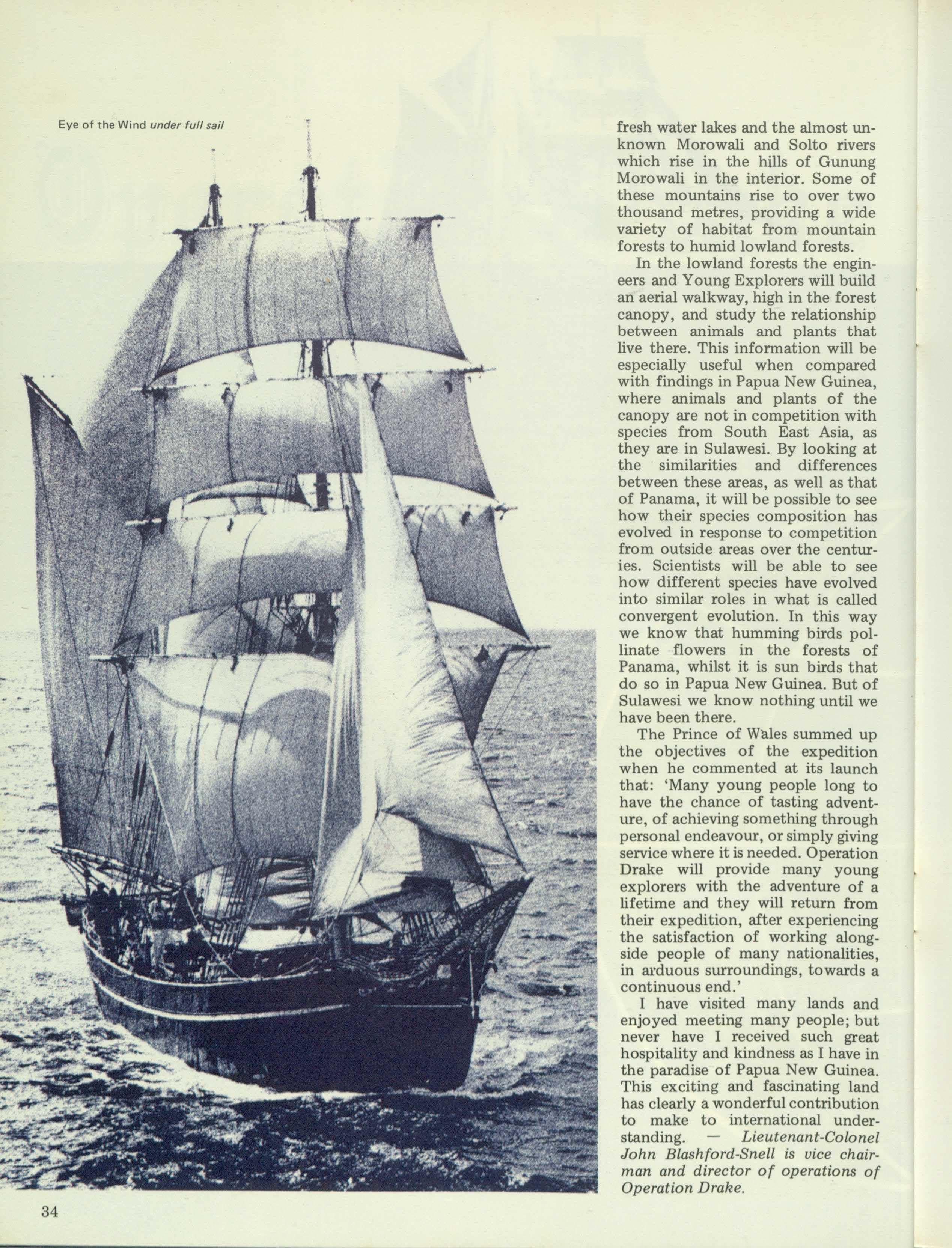
The Young Explorers comprising both boys and girls will travel from one expedition site to the next on board the 150 ton Brigantine Eye of the Wind. While on board this strikingly beautiful ship they will not only learn the art of sailing a square-rigger but also undergo preliminary training in preparation for the research projects they will be assisting with on the land phases. A marine biologist,
Eye of the Wind, will use the unique facilities of a 'clean' sailing ship to sample atmospheric and marine pollution. This survey and those on land have been designed to use standard repeatable techniques, enabling different groups of scientists and Young Explorers to carry out comparative environmental surveys. In each host country, including Papua New Guinea, local young people are to join the project.
Operation Drake's scientific committee has consulted governments and scientific institutions of host countries to boost involvement of their youth and scientists and to ensure exchange of ideas and expertise.
During my reconnaissance trips to Panama, Papua New Guinea and Indonesia I have been overwhelmed by enthusiasm and support. Now over 200 volunteer 'staff', working in 20 countries are helping to crganise what is probably the world's most ambitious large scale expedition. In Papua New Guinea much valuable work has already been done by Colonel Ken Noga of the Defence Force and Mr Louis Varo of the Prime Minister's Department.
One of the major scientific projects being carried out is an ambitious comparative survey of tropical rain forests and tropical coastal and riverine environments of Panama, Papua New Guinea and
Sulawesi. In the light of the considerable threat to these forests from commercial logging and shifting agriculture, we hope to focus world attention on the need for their conservation. These forests represent one of the earth's most valuable remaining natural resources, but with their destruction proceeding at the rate of 50 acres a minute, it is likley that within the next few decades most of the world's accessible tropical forests will have been destroyed.
All our talks throughout the countries Operation Drake will be visiting have given me a far greater understanding of the problems their governments are facing in this direction. I have been impressed by the search for the solution to the universal problem of compromising conservation and economic development. One of the areas of the tropical rain forest, about which very little is knownatpesent, is that of the life in the forest canopy, some 45 metres above ground level. This delicate environment is the 'powerhouse' of the forest, where many rare and un usual plants and animals have specially adapted themselves for survival. I have only glimpsed the fleeting dash of brilliant colour as a Bird of Paradise flits hundreds of feet above my head, during a recent trip to Papua New Guinea; and when look-
ing down from a light aircraft I am reminded that the carpet of trees below me contain about seven hundred species of birds and a variety of insects, which defies the imagination.
Some of the areas to be visited in Papua New Guinea and Sulawesi are mainly unmapped and littleknown. There are isolated tribes to be contacted and scientific knowledge to be gained. During my reconnaissance trips to Western Highlands I was daunted by the remoteness and magnificence of the country and I am determined to find a way of taking a team of scientists into the interior to carry out a series of multi-disciplinary studies. As in any far-flung area, communications present an almost insurmountable problem, but the interior of Papua New Guinea is pierced by the oldest highway known to man - rivers. It is not the first time that I have been set the problem of reaching a remote area with a scientific team. As long ago as 1968 I found that rivers offered a fast, and on the whole, reliable means of transport, when I led the Great Abbai Expedition down the Blue Nile in Ethiopia. From all I have seen of the Strickland and Sepik rivers the challenge they offer is unmatched by even the mighty Zaire.
After leaving Papua New Guinea the Eye of the Wind will set sail for Sulawesi, crossing the Banda Sea and dropping anchor in Tomori Bay, exactly 400 years after Sir Francis Drake sheltered there, in the Golden Hind during his great circumnavigation. A totally new set of problems will face Operation Drake's scientists and Young Explorers in this area of tropical rain forest when they begin a survey of the proposed Gunung Morowali National Park. Using a process known as 'Remote Sensing' the scientific team will conduct research into the geology and geomorphology of this area. This process uses some of the most advanced techniques of space technology, involving the use of satellite images beamed to earth by ASA 's Landsat programme. These images will be computer processed to reveal patterns related to vegetation, land use, to pography and other features of the environment. Ground verification of the computerised pictures will be carried out by teams of geographers and Young Explorers, who will have to penetrate the largely unmapped interior of the country.
The area of the proposed nature reserve includes an unusually wide spectrum of ecosystems, ranging from magnificent coral reefs along the shoreline and the beautiful forest covered islands of Tomori Bay, to
fresh water lakes and the almost unknown Morowali and Solto rivers which rise in the hills of Gunung Morowali in the interior. Some of these mountains rise to over two thousand metres, providing a wide variety of habitat from mountain forests to humid lowland forests.
In the lowland forests the engineers and Young Explorers will build an aerial walkway, high in the forest canopy, and study the relationship between animals and plants that live there. This information will be especially useful when compared with findings in Papua New Guinea, where animals and plants of the canopy are not in competition with species from South East Asia, as they are in Sulawesi. By looking at the similarities and differences between these areas, as well as that of Panama, it will be possible to see how their species composition has evolved in response to competition from outside areas over the centuries. Scientists will be able to see how different species have evolved into similar roles in what is called convergent evolution. In this way we know that humming birds pollinate flowers in the forests of Panama, whilst it is sun birds that do so in Papua New Guinea. But of Sulawesi we know nothing until we have been there.
The Prince of Wales summed up the objectives of the expedition when he commented at its launch that: 'Many young people long to have the chance of tasting adventure, of achieving something through personal endeavour, or simply giving service where it is needed. Operation Drake will provide many young explorers with the adventure of a lifetime and they will return from their expedition, after experiencing the satisfaction of working alongside people of many nationalities, in arduous surroundings, towards a continuous end.'
I have visited many lands and enjoyed meeting many people; but never have I received such great hospitality and kindness as I have in the paradise of Papua New Guinea. This exciting and fascinating land has clearly a wonderful contribution to make to international understanding. Lieutenant-Colonel John Blashford-Snell is vice chairman and director of operations of Operation Drake.
Eye of the Wind under full sail
An InternationalFavourite.
In 54 countries around the world San Mig is available for the traveller. Whether San Mig comes from our brewery in Port Moresby, Manila, Jakarta, Hong Kong or Spain, its quality never varies. A truly international beverage.