12 minute read
Day Trip


day trip Destination: False Cape State Park
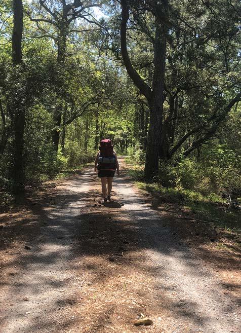
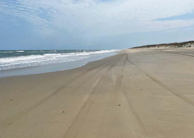
While not easy to reach, this park’s charm begins with the journey there. It was named False Cape because ships often mistook it for Cape Henry, the cape leading to the Chesapeake Bay about 20 miles north. Many ships ran aground in the shallow waters thinking they were heading for a safe shipping channel. False Cape features guided kayak trips, primitive camping, interpretive programs, hiking and biking trails, and six miles of Atlantic Ocean beach. You can access the park only by foot, bicycle, tram or boat. The difficulty in reaching False Cape State Park provides its best draw—solitude. The road less traveled gives you a natural experience unrivaled in this highly developed area. Of all the state parks in Virginia, False Cape has the most unique set of entrance requirements. To even reach the 4,321-acre park, visitors must arrive by water or travel 4-5 miles through Back Bay National Wildlife Refuge, either on the East and West Dike Trails or along the Atlantic Ocean beach. For those who want to get to the park without using their own energy, a tram exists but you must make reservations. Arriving by water means docking in the park after coming through Back Bay. All four docking areas have the difficulty of strong currents and only those with experience should attempt those entry options. For a day trip, hikers and bikers can either park at the Little Island City Park and continue for one mile of road on wheel or foot to the wildlife refuge entrance or pay $5 to enter and park in the wildlife refuge parking lot. You can only go through Back Bay National Wildlife Refuge paths April 1 through October 31.
Advertisement
[ by jill doczi ]
The best part of this park is the solitude. Take a walk on any part of the beach and you’ll be the only person leaving footprints for miles.
[ PHOTOS by Jill Doczi ]
2
1 3
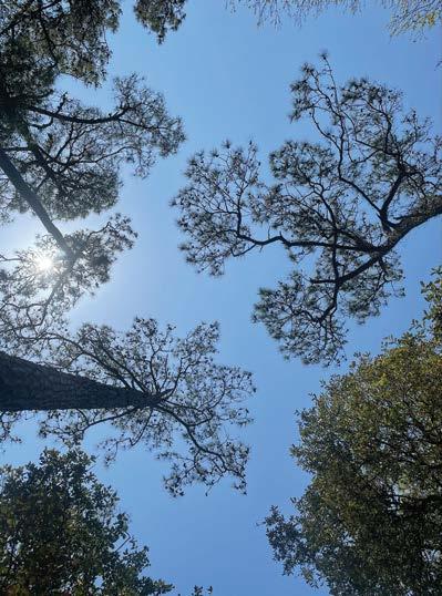
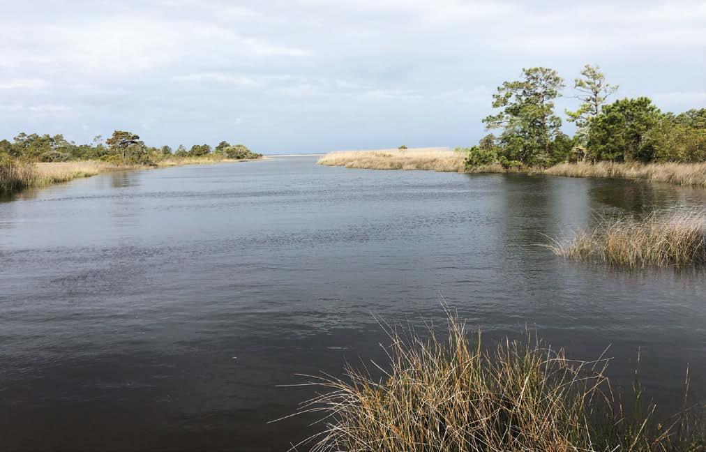
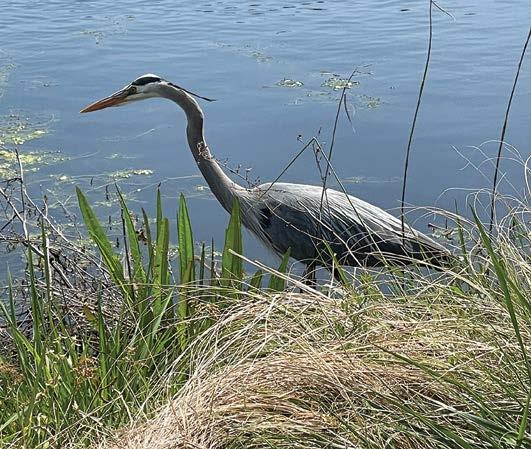
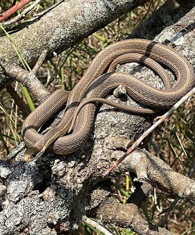
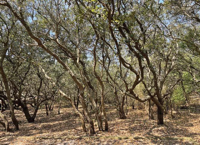
During the winter months access only exists by walking or biking the beach or by boat. Good to note: While pets are permitted in False Cape State Park, they are not in the refuge, so unless arriving by boat, your pets cannot come along. Prepare for weather conditions, bring plenty of water, sunscreen and insect repellent. Depending on the time of year, black flies and mosquitoes may bother you. Also, if hiking certain trails off the main trail, bring some leukotape, moleskin or band aids. The softer trails consist of sand, which can cause blisters. The trip through Back Bay National Wildlife Refuge by path consists of 4-5 miles of a very flat gravel-and-dirt-packed road easily traversed by walking or biking [1]. Very little shade exists for this portion of the paths so you may need sunscreen and/or an umbrella during the warmer months. Also, no restroom facilities or discreet areas exist along this route. Both the East and West Dike Trails through the refuge have beautiful continuous marsh and waterfront views. Those who fish can take advantage of several locations throughout that area to stop and drop a line in. Birders will find this portion of the way into False Cape a phenomenal place to catch some great sightings [2]. Another option to get through the Back Bay National Wildlife Refuge portion of this adventure consists of a beach walk along the Atlantic Ocean. You’ll know you’ve reached False Cape State Park when the topography changes from scrubby marsh to maritime forest. Mostly pine and live oaks line the path. Keep an eye on the ground for wiggly friends [3] as the park has many copperheads and black snakes. Larger animals you might see include coyotes, bobcats, whitetail deer and raccoons. False Cape used to have a problem with feral hogs that have since been eradicated. The park is long and thin, stretched between the North Carolina border and the southernmost part of Virginia Beach with Back Bay on one side and the Atlantic Ocean on the other. As one of the few remaining undeveloped areas on the Atlantic coast, it offers a glimpse of what our area looked like pre-resort and seaside communities. Depending on the trail you chose to come through the wildlife refuge, you have about seven miles if you want to continue straight from this point to the North Carolina
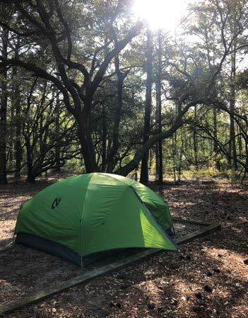
border. This park has many other options though. You could take the Sandy Point Trail to the Tundra Swan Overlook on Back Bay or Widgeon Overlook. Taking a quick detour on the end of the trail leads past one of the first primitive camping areas [4] and to one of the four locations you can arrive by watercraft—the docks. This spot offers a wonderful place to enjoy a picnic or fish. From the end of the Sandy Point Trail, you can take the Barbour Hill Trail past the visitor center to the next primitive campsite and the path to the Atlantic Ocean [5]. The visitor center, open daily from 9 a.m. to 4 p.m., offers a small variety of snacks, ice cream, souvenirs, drinks and important items. The staff there can answer all your questions, from directions to inquiries about animals. The tram option will allow you to explore this area and then the Wash Woods area farther into the park. The center also has picnic tables and indoor bathrooms. Other bathroom facilities dotted throughout the campsites are primitive pit toilets (a step up from an outhouse, but still looks like one). The first two campsites mentioned, as well as the visitor center, have potable water so you can refill. The Sand Ridge Trail continues from here all the way to North Carolina and you can take side trips to the Wood Duck Overlook, the Gadwall Overlook, Pintail Overlook and the Bufflehead Overlook before reaching the final two primitive camping areas—one to the west on Back Bay with the second location to dock a watercraft and one camping area to the east on the Atlantic Ocean. The oceanside campsite sits near the former Life Saving Station that operated from 1874 to 1946. This also houses the site of the 1863 Maple Leaf Escape (see “False Cape History” sidebar on p. 46). Just a little farther down the trail you find the Wash Woods 5
4
6
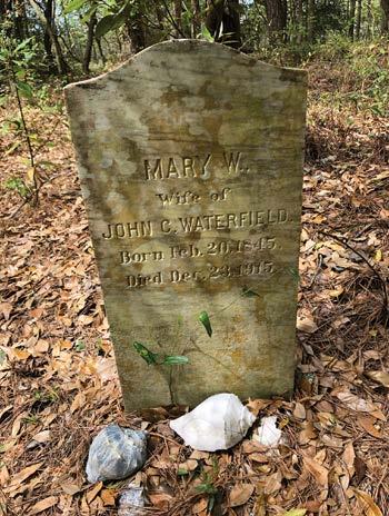
Environmental Education Center, which can be rented for overnight stays (up to 26 people) and educational events. The center offers a kitchen, restrooms, shower, meeting room, library, AV equipment and lab. The third area to arrive by boat is here as well. Nearby you’ll find the paths to the Wash Woods Church and Cemetery site where you can visit the remains of the church steeple and the former residents of the Wash Woods community at their final resting place. Traditionally local whelk shells cover gravesites both to designate the location due to shifting sandy soil and in lieu of flowers to honor the graves [6]. Follow the path to the state line and the original 1727 Survey Monument designating the state lines. Although surveyed originally in 1727, the monument was probably erected after a resurvey in 1887. Nearby you’ll find the final location to arrive by boat from Back Bay, as well as visit a pollinator field. At this point, if you take the Ocean Pearl Trail southeast to the ocean, you might catch a glimpse of the ponies that run wild on the North Carolina side of the fence or the Clythia Shipwreck of 1894 out in the surf. False Cape offers astronomy programs, wildlife tours, birding hikes, night hikes, kayak tours and special group tours. The park also offers field
False Cape History
Originally the home to Native Americans, archaeological evidence dates back 5,000 years tying humans to the site. In the 1800s, False Cape gained a reputation as a shipping graveyard. “False Cape” resembled Cape Henry, situated 20 miles to the north. Captains mistakenly steered into shallow waters here. Survivors of such a shipwreck created the Wash Woods community. The villagers built the Methodist church and other structures from cypress wood that washed ashore from shipwrecks. In the 1850s, when thousands of people in nearby Norfolk and Portsmouth began dying during the Yellow Fever Epidemic, several families also relocated to this remote area as a safe space free from the disease. The community thrived for many years, at one point reaching a population of about 300. Residents made a living working as fishermen, farmers, hunting guides and lifesavers who patrolled the beach and manned lifeboats to rescue shipwrecked sailors. The community housed many homes, two lifesaving stations, a grocery store, two churches and a school. During the Civil War, about 70 Confederate officers thought that they were on their way to City Point, VA, to become part of Union prisoner exchange. After their arrival at Fort Norfolk, however, the prisoners learned of the suspension of exchanges and paroles. They would now receive transport on the ship, the Maple Leaf, to the Federal prison at Fort Delaware. Off the coast of Virginia, they overwhelmed their captors and came ashore near Wash Woods. With some local assistance, they fled across the Great Dismal Swamp. The False Cape Lifesaving Station established in 1875 closed in 1937, was reactivated during World War II and finally abandoned on 1946. Also nearby, after several nearby shipwrecks resulted in significant losses of lives, Congress responded by establishing Deal’s Island Station, a lifesaving station in North Carolina, near Wash Woods in 1877. The station was renamed Wash Woods for the nearby town in 1883, and in 1917 the original lifesaving station was replaced by a new, more modern, U.S. Coast Guard station that continued to be manned until 1950. It was restored and now houses a real estate company. The Migratory Bird Treaty Act signed in 1918 outlawed market hunting of waterfowl followed by the category 4 Chesapeake–Potomac hurricane in1933 that caused a storm surge flooding the entire area, damaging many buildings including the Coast Guard Station. The topsoil from farm fields washed into Back Bay. The community was eventually abandoned in the 1930s with no way to live off the land. The site became the location of several waterfowl hunting clubs, one of which now houses the Wash Woods Environmental Education Center. In 1966, the General Assembly appropriated funds to match federal funds from the Land and Water Conservation Fund to acquire False Cape State Park. In 1980, the park opened with trails, boat docks and primitive camping. trips and overnight experiences that focus on environmental education. Visit www.dcr.virginia.gov/stateparks/false-cape#park_trail_guide to view all parks’ events, festivals, workshops and interpretive programs. The best part of this park is the solitude. Take a walk on any part of the beach and you’ll be the only person leaving footprints for miles. The main paths through Back Bay National Wildlife Refuge and through False Cape State Park may have more bikers, hikers and in certain spots, tram riders, but the side paths offer a quiet opportunity to explore untouched nature.

Tram Tours All tram tours require a reservation. Please call the park office at 757426-7128 to make your reservation. The tram for False Cape operates from April 1 through Oct. 31. Back Bay National Wildlife Refuge partners with False Cape State Park throughout the year on the Blue Goose Wildlife Tram. During the trip, participants visit the refuge impoundment complex, as well as tour of the state park’s historic site of Wash Woods. Trips are four hours in length, leaving at 9 a.m. and returning at 1 p.m. and cost $8 per person. A one-mile, optional, hike to the Wash Woods cemetery and church steeple is included.
Fishing A valid Virginia saltwater or freshwater fishing license is required depending on where you fish in the park.
Drones and Other Aircraft Drones, other unmanned aerial vehicles, including remote control aircraft, and aircraft in general may not be flown in state parks pursuant to 4VAC5-30-400.
Hours The park is open sunrise through sunset daily. Please note that day guests must be out of the refuge
False Cape offers astronomy programs, wildlife tours, birding hikes, night hikes, kayak tours and special group tours. The park also offers field trips and overnight experiences that focus on environmental education.
within 30 minutes of sunset. Guests may access the park by bike or watercraft. The visitor center is open daily from 9 a.m. to 4 p.m.
Getting There From Interstate 64, exit on to Indian River Road East. Go 13 miles, then turn left onto Newbridge Road, then right onto Sandbridge Road. Next, turn right onto Sandpiper Road to Little Island City Park. Parking fees are required from Memorial Day to Labor Day. Day-use only parking also is available at Back Bay Wildlife Refuge. From First Landing State Park and oceanfront, turn east onto Shore Drive (Route 60); follow Pacific Avenue to General Booth Boulevard, then left on Princess Anne Road and then straight onto Sandbridge Road. Turn right onto Sandpiper Road to Little Island City Park. Parking fees are required from Memorial Day to Labor Day.
Note: Groups of 10 or more are required to obtain a special-use permit from Back Bay Wildlife Refuge two weeks in advance of the trip. Join the Friends of False Cape State Park. The nonprofit citizen group provides voluntary help to DCR for the preservation and conservation of the park. The group educates the community about park offerings and supplies funds, materials and labor for special projects. Its success depends on those who appreciate the outdoors and wish to preserve this special place. Members enjoy special friends-only events throughout the year. Learn more about the group by calling or emailing the park.
Planning to take a road trip somewhere within a day’s drive? Tell us about the experience. Send in your piece (and any photos you take) for us to consider publishing in a future issue of Boulevard. Email: julie@blvdmedia.io
False Cape State Park
4001 Sandpiper Rd. Virginia Beach 757-426-7128 www.dcr.virginia.gov/state-parks/ false-cape#general_information