West Kootenay Advertiser
Thursday, April 1, 2021 A3
News
Revisiting a local park’s storied but forgotten past by Jonathan Kalmakoff and Greg Nesteroff
First of four parts Although Grohman Narrows Provincial Park west of Nelson is a well-known destination for local outdoor recreation and nature appreciation, its storied past has largely slipped from collective memory. This series examines the property’s many different owners, occupiers, names and uses over its 150-plus years of recorded history. Prehistory The property covers the river flats on the left (south) bank of the Kootenay River at what was once called the Narrows, a natural constriction of the river at the downstream end of the West Arm formed by beds of uneroded hard rock. During periods of high inflow into Kootenay Lake, the constriction raised water levels upriver, causing flooding. The rich alluvial material deposited over millennia enriched the lower portions of the flats, yielding fertile soil, while the higher, unflooded portions remained largely exposed rock. For centuries before white settlers capitalized upon its agricultural potential, First Nations encamped on the flats, as the Narrows created an ideal location for trapping fish. Its importance as fishing grounds also made it highly sought after, and it is thought to have been the site of a 19th century battle between the Sinixt and Ktunaxa over its control. In the early 20th century, many First Nations artifacts were recovered along the flats. W.A. Baillie-Grohman In 1886, 50 acres of the flats were conceded to the Kootenay Lake Syndicate led by Anglo-Austrian author and hunter William Adolph Baillie-Grohman as part of a plan to blast out the Narrows, thereby lowering the lake level in order to drain and reclaim Creston Valley and Kootenay Flats for colonization and agriculture. In 1889, Grohman’s engineer Leslie Hall and his crew set up camp on the flats, detonating tons of dynamite against the obstructing rock at the Narrows, but the rock did not yield. By 1894, the scheme was a bust and the land reverted to the Crown. More enduring were the names left behind in the form of Grohman Narrows and Grohman Creek, opposite the property. Early Miners and Ranchers In 1891, the CPR’s Columbia and Kootenay Railway line was built through the north edge of the property, close to the river, opening it up for mining and later agricultural development. By 1898, Dr. E.C. Arthur of Nelson staked the Recluse mineral claim on the property, receiving certificates of work in 1903 and a grant of mineral rights in 1905 as Lot 4228. Dr. Arthur still owned the claim as of 1908, but it was sold for unpaid taxes soon thereafter. A brickyard also reportedly existed in the vicinity, but it’s not clear who operated it. Meanwhile, in 1901, New Brunswick native Alfred Bunker (1855-1937) received a Crown grant for the 50.6-hectare (125-acre) property (Lot 5180), subject to the mining claim, for $125. It thereafter became known as the Bunker Ranch. By 1902, Bunker cleared some 10-12 acres and planted about 1,000 fruit trees on the ranch, including cherry and pear, and cultivated
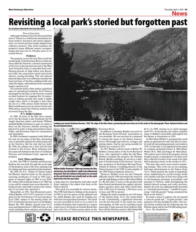
Looking west toward Grohman Narrows, 1928. The edge of the flats where a provincial park now exists are in the centre of the photograph. Photo: National Archives and Records Administration & Co. in 1908, staying on as ranch manager Kootenay River. In addition to farming, Bunker was active in until 1911. In the interim, the realtors satisfied the Kootenay Fruit Growers’ Association as many of Hulbert’s local debts, although he lost vice-president. He was involved in a proposal his theatre to foreclosure in 1910. to assume the assets of the Nelson streetcar As McCallum Hill & Co. purchased the ranch service. He bought and sold lots, cottages, and under an agreement for sale, title did not transmining claims. And he ran unsuccessfully for fer until all outstanding payments were made in Nelson city council in 1912. 1910. At that time, it was registered in the names In 1907, Bunker sold his ranch to Robert W. of company principals Ernest A. McCallum, Hulbert, former editor of the North Battleford Walter H.A. Hill and Edgar D. McCallum. News, who registered it under his wife Rose. The realtors never lived at the property, having Hulbert renamed the property the Durban bought it purely on speculation. For three years Ranch. Besides ranching, he served as a dele- they collected revenues from ranch fruit sales gate of the Kootenay Fruit Growers’ Associa- before placing it back on the market in 1911. tion, proprietor of the Empire Moving Picture This time, they used a more creative marketTheatre in Nelson, a founding director of the ing strategy. They took out an eye-catching, William Baillie-Grohman’s 1886 map showing the flats Nelson branch of the YMCA and compiler of half-page advertisement in the Nelson Daily and narrows, here described as “rapids to be widened and the 1909 Nelson telephone directory. News, which painted the ranch in hyperbolic deepened.” Note the railway at that point was surveyed However, Hulbert soon ran into financial terms, emphasizing its overall acreage, fertile on the north bank but was actually built on the south difficulty and by 1908 advertised the ranch for soil, number and type of fruit trees along with bank of the river five years later. sale through Regina realtors McCallum Hill & its development potential, accessibility and a large piece for strawberries and other small Co. By this time, 25 acres of the property had nearness to Nelson, while downplaying the fruits, making it the oldest fruit farm in the been cleared and planted into apples, cherries, limited cleared acreage and rocky portions. Nelson district. plums, peaches, pears and other small fruits, Indeed, the rock was euphemistically described The ranch was accessible by various means. with 1,000 trees in bearing, 1,200 more soon as “extremely picturesque,” “suitable for quarThe CPR built Quarry Siding on the property to bear, and 500 in nursery. rying,” with the granite “being considered the in 1902 to serve its quarry on the adjacent east Despite the advert running in over 105 issues finest in the district.” lot, which Bunker also used for loading cars of the Nelson Daily News, the ranch failed To create a sense of urgency, the ad stressed with fruit and agricultural products. The ranch to sell. Undoubtedly, a significant deterrent a “price for quick sale,” “at great sacrifice” and was also accessible by boat or via a road at its was the fact that half of the ranch was rocky imposed a five-day deadline for offers. The twosouthern boundary that connected to a wagon outcropping, of little use for anything except day listing worked and the following day the road (soon to be known as Granite Road) that quarrying. Under pressure from creditors, Hul- Durban ranch sold for the $10,000 asking price. led to the City of Nelson power plant on the bert sold the Durban ranch to McCallum Hill Next: The Doukhobors
PLEASE RECYCLE THIS NEWSPAPER.
What do SPCA cats daydream about? Your loving home.