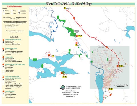
Trail Information
Your Trails Guide To The Valley T WOOSLEY RD
Symbols:
P
Parking
Biking
Horse Back
Hiking
T
20k
Wheelchair Accessibility Trail Access
Easy: Little Effort Moderate: Some Hills Difficult: Steep Hills
11
The Alberni Valley Search & Rescue encourages you to get out and enjoy the outdoors safely. Leave a trip plan with someone!
15k
• Date and time of departure • Your planned route • Expected return time STAMP FALLS PROVINCIAL PARK
Maps not intended for navigational use Distances are approximate
12 T P
Valley Trails
10k
8 GREENMAX ANGLERS TRAIL
P
Distance: 4.1 km Difficulty: Easy Trail Access: Coleman Road
9 ALBERNI INLET TRAIL Distance: 12 km Difficulty: Moderate to Difficult Trail Access: Ship Creek Road Parking Lot
8
T
McLean Mill Historic Site
11 5k
P
10 FOSSILI PARK
P
13
T
Distance: 2.5 km Difficulty: Moderate Trail Access: Stirling Arm Road
11 ALBERNI VALLEY LOG TRAIN TRAIL
P
12
P
Distance: 25 km Difficulty: Easy Trail Access: • Mozart Road, • Burde Street
SAYACHLAS T’A SAA’NIM (STAMP LONG RIVER TRAIL) Distance: 2.5 km Difficulty: Moderate Trail Access: • North access at Barker Road • South access at Stamp Falls Provincial Park parking lot Washrooms
13 TEODORO TRAIL
P
Distance: 5 km Difficulty: Moderate Trail Access: • Off Highway #4
11 T P
10
P T
ALBERNI-CLAYOQUOT REGIONAL DISTRICT
ALBERNI-CLAYOQUOT REGIONAL 3008 5thDISTRICT Avenue Port Alberni, B.C. V9Y 2E3 NOTICE OF CHRISTMAS CLOSURE Telephone (250) 720-2700 Please be advised that the Alberni-Clayoquot Regionalwww.acrd.bc.ca District office will be closed from th st
Tuesday, December 25 through Tuesday, January 1 . The office will reopen for business as usual at 8:00 am on Wednesday, January 2 nd, 2013. This closure impacts the Alberni-Clayoquot Regional District office only.
For more trails and City Map see back page
T P 9