Photographs courtesy of Nakusp Chamber of Commerce, B. McLeod, B. Regner, Marks and Weixl
FREE
All photos courtesy of Gail McMartin Ferry leaving Shelter Bay Early morning sun on the Saddle Back Range Ione Falls
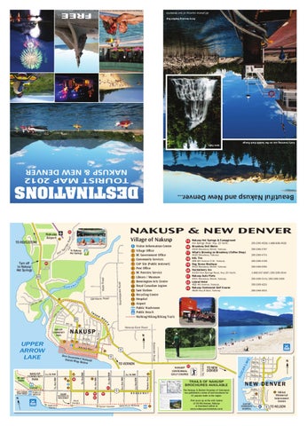
TOURIST MAP 2012 NAKUSP & NEW DENVER
DESTINATIONS
NAKUSP & NEW DENVER
sR oad
15 14
Village of Nakusp
pr
ing
TO REVELSTOKE t Ho
To Nakusp Hot Springs
S
20
k ee
Cr
u
x
Ku s k a n
Glenbank Road
11
W v. N th A
Shakespeare Road
23
Wells Road
Turn off to Nakusp Hot Springs
Beautiful Nakusp and New Denver...
Nakusp Airport
Av .N
W
13
10
th
TR
UC
K
23
RO
i Visitor Information Centre 2 Village Office 3 BC Government Office 4 Community Services 5 CAP Site (Public Internet) 6 Post Office 7 BC Forestry Service 8 Library / Museum 9 Bonnington Arts Centre 10 Royal Canadian Legion 11 Sani Station 12 Recycling Centre 13 Hospital 14 Airport Public Washroom Public Beach Walking/Hiking/Biking Trails
15 Nakusp Hot Springs & Campground Hot Springs Road, Hwy. 23 North.
250-265-4528/1-866-999-4528
16 Broadway Deli Bistro
#408 Broadway Street, Nakusp.
250-265-3767
17 What's Brewing on Broadway (Coffee Shop) #420 Broadway, Nakusp.
250-265-4701
18 KAL Tire
#95 6th Avenue N.W., Nakusp.
250-265-4155
19 Dog Sense Boutique
#312 Broadway Street, Nakusp.
250-265-0091
20 Huckleberry Inn
#1050 Hot Springs Road, Hwy 23 North.
1-888-287-9297/250-265-4544
21 Nakusp Auto Parts
#301 Broadway Street, Nakusp.
250-265-3131/250-265-3355
22 Leland Hotel
#92 4th Avenue, Naksup.
250-265-4221
23 Nakusp Centennial Golf Course #649 Hwy 6 East, Nakusp.
250-265-4531
U
18
i 6
17
RAMP ACCESS TO WALKWAY
N
10
3rd Ave NW
8
16
1st St NW
21 19
6
2
BROADWAY
Point
GPS
P
50º 14’ 15” N 117º 47’ 51” W
1
50º 14’ 17” N 117º 48’ 11” W
Description Nakusp Marina Spicer’s Garden
2
50º 14’ 19” N 117º 48’ 30” W
Japanese Garden
3
50º 14’ 23” N 117º 48’ 31” W
Public beach & park
4
50º 14’ 41” N 117º 48’ 46” W
Trail & 4th St NW
5
50º 14’ 57” N 117º 48’ 38” W
6
50º 14’ 27” N 117º 47’ 41” W
Trail & Gov’t Rd
7
50º 14’ 24” N 117º 47’ 36” W
Dirt trail to town
Trail & Highway 23
This four-season trail circles the picturesque village of Nakusp, providing a 5 kilometre circuit for strolling, dog walking, jogging, or biking, with portions also accessible to wheelchairs, rollerblades, and baby carriages. The circuit includes the paved Waterfront walk, extending along the top of the soil erosion protector for 1 km from the Marina to the beach. The Walk is renowned for its handsome landscaping, including Spicer’s Garden (GPS Point 1 on the map) in the middle and the Japanese Garden (GPS Point 2) near the beach. At the other end of the beach, the gravel Greenways extension begins (GPS Point 3). The groomed gravel path winds through the shade along the lakefront for 800 metres, providing benches for repose and nature watching and some hills for exercise. A 500 metre gravel lane at the end of 4th St. NW (GPS Point 4) links the Greenways Extension to the Railway Trail that begins across Highway 23 (GPS Point 5). The Railway Trail is a reclaimed railway bed that stretches to Rosebery, 46 km to the south. About 300 metres past the junction with Government Road (GPS Point 6), a path branches off the railway trail to head back downtown (GPS Point 7). From the corner of 1st Ave and 1st St., the path continues along streets back to the Marina.
22
AK
TO NEW DENVER
TRAILS OF NAKUSP BROCHURES AVAILABLE
Wrap Around Nakusp Rating: easy Distance: 5 km Time: 1 hour Surface: pavement, gravel, dirt Modes: walk, bike, roll, push
Trail Description
The Nakusp & District Chamber of Commerce has published a series of trail brochures for 10 popular trails in the region.
Although there are many access points along the trail, the Nakusp Marina is a nice place to start your Waterfront Walk. Located at the bottom of Nelson Ave., the Marina has ample parking space and a covered picnic area with luscious arbour gardens (GPS P ).
Modes of Use
Waterfront Walk—hike, bike (with caution), wheelchairs, rollerblades, or any non-motorized modes of transportation. Greenways Extension—hike, bike, baby carriages possible, but there’s one short, steep hill. Railway Trail—hike, bike, small motorized vehicles and horses. Pathway from Railway Trail to Marina—bikes and foot traffic only—somewhat steep with a loose, ungroomed surface.
Past and Future
Spicer Garden
Waterfront Walkway
11
When BC Hydro flooded the Arrow Lakes in the 1960’s, a cement soil protection barrier was constructed along the town’s waterfront. Over the years, volunteer work, grant monies and the Village of Nakusp have developed the Waterfront Walk to its present beautiful state, with its commemorative benches, trees and ample gardens. The Greenways Extension was added in the late 1990’s with the help of federal government grants and local workers. The Village of Nakusp has plans to further upgrade the trail around town, so it will only get better!
If You Liked This Trail
If the Wrap Around Nakusp trail appealed to you, try Cedar Grove Loop, Box Lake Loop or portions of Rosebery Railway Trail, which are also relatively short, easy hikes in this area.
¤D. Booth The Japanese Gardens offer a peaceful rest stop and phenomenal view.
8th Av.
N
6
7th Av. 6th Av. Slocan Av.
NEW DENVER 3rd Av.
Nikkei Memorial Internment Centre
28
28
1st Av.
Access
Rock Garden Japanese Garden
E 23
NAKUSP CENTENNIAL GOLF COURSE
NL
TO VERNON
4th Ave NW
5
5th Ave NW
7th Ave NW
PUBLIC BEACH
7
6
Henke Rd.
See Dow nto Detail M wn Nakusp ap Belo w
CA
6
13
SLO
WAY
Nelson Ave
BROAD
1st Ave NW
1st St.
2nd Ave NW
.
4
Nelson
3
N Alexander Road
OFF LEASH DOG AREA
2nd St
i
NAKUSP 1st St NW COMMUNITY RV DAY PARK PARK GAZEBO
Nakusp East Road
NAKUSP
12
UPPER ARROW LAKE
9
Av. NW
NAKUSP COMMUNITY PARK
TE
4th St.
Pick yours up at the Info Centre at 92-6th Avenue, Nakusp or download online at www.nakusparrowlakes.com
SLOCAN COMMUNITY HOSPITAL
H
6
TO NELSON