site master plan and land-use strategies
open-space diagram
land-use diagram
2
3
4
1
2 8
9
AR
3
10
4
20
5 11
12
18
19
6
13 14
16 22
agricultural land
residential
Highway
irrigation canal park
government
2 New Bridge
mountain creek park
commercial
3 Hydro-Electric Dam
park corridor
sport
4 Outfall Channel
central park
city plaza
5 Moon Lake
sports fields
beaches
6 Rubber Dam
wetland park
internal waterway
7 Anning River
forest open space
anning river
8 Culture & Arts District
city plaza
public green space
9 North Lake
beaches
protected green space
10 Family Rec Center
internal waterway
1 Panzhihua-Xichang
21
7
& Aquatic Park
11 Sports Complex
15
anning river
12 Central Park 17
13 Wetland Park 14 Working Agriculture 15 South Lake 16 Medium-Density Housing 17 Dock Housing 18 Promenade District
23
19 Landmark Building 20 Constructed
Floating Wetlands
21 Terraced Outfall
to South Lake
22 Wetland Outfall
to South Lake
23 Outfall into Anning River
0 50 100
200
300
400
500m
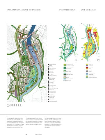
2 The master plan for the 200-hectare site provides housing and amenities for a projected 95,000 residents as well as attractions and facilities for tourists and regional visitors. At the core of the design is a highly programmed water treatment system that runs parallel to the existing Anning River.
3 The master plan employs a wide range of open-space types to accommodate both the local community and tourists, while taking full advantage of the programmatic potential of the improved hydrological system.
58
SWA_01_Performance FINAL.indd 58
4 Land use is arranged according to a number of factors, including water program, proximity to the existing town, and access to open space. Special features include the preservation of a large parcel of waterfront agriculture and a new linear water treatment system.
performance
06.12.10 16:08