


ARCH 402-Spring,2018
Kalkan, Antalya Kutay Karabağ & Nilüfer Kozikoğlu

SCHOOL OF GASTRONOMY AND EARTH MARKET
collaborating with Elifsu OTURAN and Dilara EMEKTARStudio aimed to us utilize various information and skill for organizing complex architectural functions in coherence. In doing so, we are asked to develop our propasal based on site analysis. So project brief was analyse the project area and develop a design strategy in a rural area. The project area located in Kalkan which is one of the prominent regions of Turkey in terms of summer tourism. Kalkan is a land with high biodiversity. As a result of the analyses that we made of Kalkan district, we had observed agricultural wise and localness is active and rich but area cannot finding a proper response to this situation. we had an intense research period due to location, scale and context differences, and we got information about the surrounding areas of the town, such as history, production, and locality. After learning all this, we created an approach strategy to the project. In this strategy we decided that the option will shape our design without disrupting the integrity is to focus on localness. At the same time, since we have an obligation to create a complex architectural program, various functions that constitute our design have occurred. These are the earth market, camping area, trekking parkour and gastronomy school.


The main purpose of our project is to be in nature and to exhibit the products made by nature and to educate on flour. While doing all these, we used light structures as building materials. Although Kalkan has many features that we learned, our main focus is what was produced locally. We searched what was produced with agriculture in all villages about 15 km from Kalkan. A lot of products is grown in the nearby areas but Kalkan which is favorite place with summer tourism, cannot use this situation at all. In this way we wanted to bring the products grown in the villages to the center and make them accessible to everyone which led us to examples ofEART MARKET and we added an additional MARKET AREA to it. Besides these our project area includes a historical building which is a high school so we contiuned the educational program and added GASTRONOMY SCHOOL. The surrounding area of site has 2 important historical textures, one of them is a old town which called ‘Köyiçi’, other one is a historical protected that we had a proposal for this place also. The other side of our site is new settlement that means our site is transit area between old and new. Our design approach was making our decisions by taking into account the historical elements was one of our priority issues.
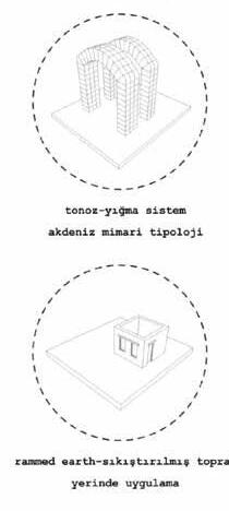
Since our region was very inclined and we started to see as a transition point, we started to zone the site by determining entry routes, axes and arranging them with height of the ground. Since there are many units that have historical conservation status in and around our area, we used light structural systems and traditional elements as the mass approach. We tried to use the elements used in mediterranean architecture that have historical conservation status in and around our area, we used structural systems and traditional elements as the mass We tried to use the elements used in mediterranean architecture in general


By working on the models, we determinedthe elevations and our mainroute as we think that theycan interact with site’s environment inthe best way. Later, we divided our site into three parts. However, we didnot set clear boundaries between them interms of creating aunity.We drawa part areasand merge them. I mostly dealt with historical school, educational masses, parking areas, slope arrangementsand subterreanean parts. Thus, the northside of the site and elevation 28 and above of it.


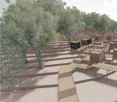


steel work blocks for earth market


timber-framed blocks masses for accommodation protected area


light structure modelling


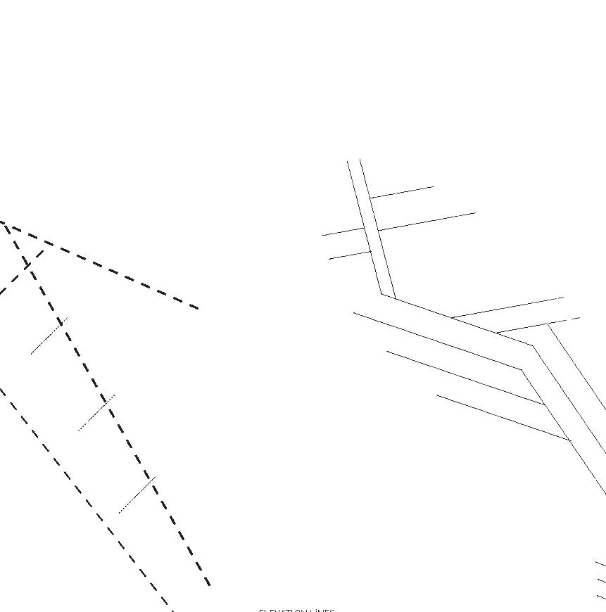
 1/200 scaled section
1/200 scaled section
1/200 scaled section
1/200 scaled section
1/200 scaled section


 1/500 scaled section
1/200 scaled section
1/200 scaled section
1/200 scaled section
1/500 scaled section
1/200 scaled section
1/200 scaled section
1/200 scaled section
ARCH 401-Fall,2017
Fatih, Istanbul Alişan Çırakoğlu &Tansel Korkmaz
SCHOOL OF ARCHITECTURE


The studio’ s objective of this semester was to understand and comment on valuable object of architecture its position within the historical and urban context. As students, we tried to develop design suggestions by identifying their current context, structural and environmental data, values and problems. So the project brief was to design a school of architecture in Vezneciler that will be a part of Istanbul University. The curriculum was open to interpretation so are all the facilities. The school needed to focus on issues and studies concernced with restoration and historically conscious design and
he curriculum was open to interpretation so are chool studies oration and y conscious ies that would suppor t those studies.


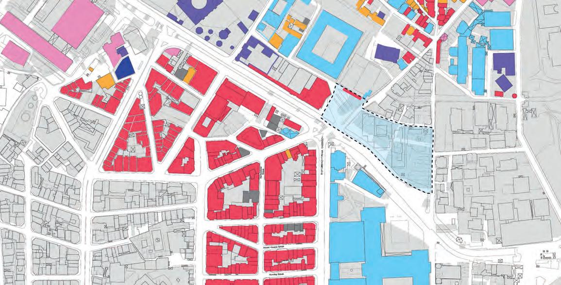
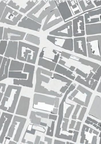
Vezneciler district where the project area’ s located is in middle of


BC 685. In this sense, there is a wide history that make it a perfect place to study restoration and historically sensitive design. So area is surrounded by historical landmarks. It is on Mese(Divanyolu) which has been the main axis of yhe city for almost two hundred years. Also, Mosque(A.C. 1557), Kalenderhane Mosque(9th-10th century), Bozdoğan Aqueduct(4th century), Beyazıt Mosque(A.C. 1506), Şehzade Mosque( A.C. 1548), Grand Bazaar( A.C. 1461), Istanbul University Faculty of Science and Literature( A.C.1947), Istanbul City Hall(A.C. 1953), Istanbul University Main Campus( A.C. 1453),and an open market area called Direklerarası which is demolished but was the meeting and entertaintment point of the people between 19th century and 1960s, the area that does not exist as a building but has a memory value. So student at this architecture school proposal
values and chaos.
The project began with a set of conventional and objective analyses, such as Nolli Map, walking distance map, landuse map that aim to simply break down the urban and architectural elements, dynamics, problems, values in order to deduce spatial and contextual information.


Furthermore, my proposal for the design, ı started to make personal observations and experiences, as a result of these the purpose was to see how spaces are in interrelated and what sort of dynamics bind them to each other.


So, after observing and walking around within the surrounding built environment of the project area, made soid and void maps on old peninsula’ s maps for Ottoman ages and Byzantium ages. There are


focused on one of the similarities. That is The Mese axis. I realized that all of the administrators who are kings or sultans or even modern days ones use this axis or build one.

On the other hand, while they make themselves a new wide, silence, empty and oriented prestige way, they damaged the existance, made new large building nearby.Beside all of these documentical informations i realized that other buildings such as bazaars, houses that ordinary people who are not an administrators uses, were not oriented, not large, not in any order. They were deveped ramblingly. Creating spaces small yet very dense, choatic but intimate. Contrary to this oriented prestge ways imposes a direction and made to think unseen, intangible power.
Although, all of these made me think and realized that there was a negative quality in this situation. At this case historical peninsula has been inholding multiple contrasts and these make lots of areas dark, desolate and restricted because of opposities. That means there has been an alienation between conctructed and planned spaces and random, unplanned spaces.

So understanding the aspects of the situations, the design approach was the creat spaces narrow, long, complex, desolate and restricted spaces by planned not to be in a tight situation.


complex, public transportation hub, subwayaccess, public library, public working areas

Subterranean level allowsfor subway access.There are several exhibitions areas that any gallery can use, there are ateliers for student using besides that they can be use from outside bytaking appointments.
To access this level people can use large stairs from ground level which the stairs other purpose is using as an amphi. An auditorium also takes a place in this level.


The ground level has accessto library which is for public using with student use. There are working rooms, stores, cafes and a gallery which is for school using. The access tothe school is close tosubwayground access.
Another entrance for school of architecture is


ARCH 302-Spring,2017
Architectural Design IV
Beşiktaş, Istanbul Banu Tomruk & Eylem Erdinç
LEVENT VOCATIONAL SCHOOL

This semester’ s studio aimed to focus on design as an urban intervention. so, we struggled with the larger urban fabric. We exanimed the main building blocks of the city, the residential buildings and we worked on the architectural types and urban conditions.We tried to create an architectural position by making individual and collective analyzes, design ideas and produse residential and mixed-used projects that include tips of an urban order beyond the physical intervention limits of the project.

İstanbul so doing building nearby the buisness world and
Furthermore, we were asked to rebuiltThe EtilerVocational School and add additional programs in the area. So project
side which is above from Ebulula Street, is the modern garden city housing which converted to commercial using through years, one side that is above from Meydan Street, is the early modern apartments which tried to solve overpopulation in the 80’s, the other side is the Nispetiye Street which is the major side streets of Büyükdere Street and high density commercial and residential use.
So my proposal from the analyses was creating semi public spaces for pedestirans. I tried to create open space by creating transitions between parks and building. I focused on making transtions between public areas and private places, so most open places is on the Nispetiye Street side.


Hotel Building_5500m2 100 room,reception,lobby, service areas
Vocational School_1800m2 classrooms,workshops, service areas

Public Center Building_4200m2 exhibition space,stores, cafe/restaurant,library, game center space
Multifunctional Hall_52v0m2 150 seat,foyer, stage/bacstage, service areas


 1/200 ground level plan mass diagrams
1/200 Hotel Building Sections
1/200 School Building Sections
1/200 Hotel Building Elevetaions
1/200 School Building Elevetaions
1/200 ground level plan mass diagrams
1/200 Hotel Building Sections
1/200 School Building Sections
1/200 Hotel Building Elevetaions
1/200 School Building Elevetaions


MODA
ARCH 301-Fall,2016
 Bülent Çetin & Emrah Altınok
SWIMMING POOL
Bülent Çetin & Emrah Altınok
SWIMMING POOL


Thissemester’sstudioaimed to develop a urban projectfor a public building in acentralcomplex urban setting. So project brief were askedto doa public pool in Moda, Kadıköy. Indoing sowe began with intense phase of site analyzes. Analysesaim to understand the local urban dynamics.We searchedforthe programsaround, urban formations in the surrounding area, alsowe did analysesto understand the density of the phsical environment inthe neighborhood.
Somy proposal is creating ahigh quality city life to make sure localsstay and have allthe necessary fasicilities for them tomaintain ahigh qualitywayof life. In addition to that ıwantedto create a passage park between residential areaand ModaStreetwhichisone of the popular and crowdedstreetsin Istanbulthat providesvariety entertaintmentchoices.
The main purpose wastocreate calm, green void in contrast withrest of the crowded places inKadıköy
Moda hasretaineditsresidential urban chracter for years, due toitsrelatively positionwithinKadıköy. Recently, the numberof people from outside Moda who spend time in cafes, bars, restaurantshere butthis made local’s life harder.
e r.


includes equipmentstore, administration and kindergarden.Those are 350 m2 intotal. andcarpark.


and poolthatissemiolympic(25m-12,5m)


 1/200 AA’ section
1/200 BB’ section
1/200 CC’ section
1/200 DD’ section
1/200 AA’ section
1/200 BB’ section
1/200 CC’ section
1/200 DD’ section
ARCH 202-Spring,2016
ArchitecturalDesign II

Adatepe,Çanakkale Burcu Kütükçüoğlu & Göksenin Ekiyorum
SUPERSONIC STONE CENTER/COLLATERAL

The main purpose of our project is to be in nature and to examine architectural projects of low to medium complexity. Besides the concepts of body and space, context, physical environment and tectonic issues are covered. Also, the project aim to demonstrate the suffiency in design by associating the poetics of architectural space as related to the tectonics of architectural structures.

One of the aim is to create a harmonious relationship between architecture and urban space by designing various hierarchical diversity spaces from public to private.
The design wants to achive to explore contexts between the language of construction and working in different environmental conditions architecturally.
The site is located in the unusual topography of Adatepe, located in Kaz Mountains, Turkey.
The project area overlooks the unused old stone quarries. The project was sketched through the abstraction of the shapes of the stones. triangulation samples are obtained as a result of abstraction of stones. The architectural program includes stone workshop and accommodation functions for 5 people.


 1/5000 scaled site plan
1/500 scaled sections
1/5000 scaled site plan
1/500 scaled sections


