
SHARED PATHS of BALLINA SHIRE
EXERCISE your DOG
Get out and about with the whole family and enjoy walking your four-legged friend in Ballina Shire.


Dogs must be on a lead at all times in public places, unless in one of our seven off-leash areas
THE PATH is THERE to SHARE
Shared paths are for both pedestrians and bike riders.

BIKE RIDERS SHOULD:
RIDING on the ROAD
OFF LEASH AREAS
Bicentennial Gardens, Ballina Compton Drive, East Ballina Gap Road, Alstonville
Seven Mile Beach north of surf club, Lennox Head Ballina Heights Eastern Reserve Headlands Drive Drainage Reserve, Skennars Head
The Spit, Ballina
Please be considerate of other users of these areas. Your dog must always be under effective control.
Take note of onsite signage about dog
KEEP BALLINA BEAUTIFUL
Remember there’s no such thing as the dog poo fairy! Bag the poo, bin it or take it with you.
ballina.nsw.gov.au/ ExercisingYourDog for more information
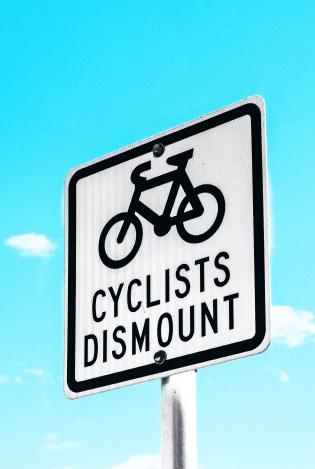
DISMOUNT AREAS
Bike riders must dismount and walk their bikes: on footpaths to use pedestrian crossings at the end of shared paths. LOCK
BIKE RIDING SAFETY

Give way to pedestrians
Keep left unless overtaking
Ride at low speeds in busy areas when approaching corners and crests
Ring your bell and slow down when approaching other path users
Where possible, allow onemetre space for pedestrians
Move off the path if stopped.
PEDESTRIANS (including walking, jogging, skating, mobility scooters and motorized wheelchairs) SHOULD:
Keep to the left

Travel in a predictable manner
Listen for the sound of a bell and avoid moving into the path of a bike

Supervise young children at all times
Keep dogs on short leashes
Move off the path if stopped.
MOBILITY SCOOTERS SHOULD:

Follow the same rules that apply to pedestrians
Ride on the footpath or shared path, not the road
Not exceed 10km/h
Ride at walking speed (2-3 km/h) in busy pedestrian areas
Use baskets or racks: overloading may affect balance and control


Health and medications may affect your ability to use your scooter: check with your doctor or pharmacist.
CYCLEWAYS and SHARED PATHS of BALLINA SHIRE
 North Wall Ballina
and
When riding, you are required by law to wear an approved bike helmet fitted and fastened on your head
riders must have a working brake
you have a fully functioning bell, horn or other warning device Lights and reflectors increase your visibility. By law, you must have your lights on between sunset and sunrise, and in bad weather
Bike
Ensure
red reflector
rear.
You should also have a
visible from the
IT UP! Avoid theft and secure your bike when unattended. Carry a good bicycle lock and secure the wheels and frame. South Ballina Ballina Wollongbar Alstonville Tintenbar Knockrow Wardell Lennox Head
obey the road rules including helmet laws Ride in a predictable manner You are permitted to ride two abreast, but not more than 1.5 metres apart Give hand signals when changing lanes turning left, right or stopping Plan your route using quieter streets, cycleways or shared paths. Visit www.gotogether.transport.nsw. gov.au for more information on sharing roads and cycleways. Shaws Bay Loop Walk Angels Beach
CBD
Shaws Bay EXPERIENCE the BALLINA COAST and HINTERLAND
BIKE, SCOOTER, ON FOOT and WITH YOUR PET DOG friendly AREAS + WANT to KNOW MORE? Ballina Visitor Information Centre Ph: 1800 777 666 discoverballina.com.au ballinacoastandhinterland Ballina Shire Council 40 Cherry Street, Ballina Ph: 1300 864 444 ballina.nsw.gov.au ballinashirecouncil .nsw.gov.au Lennox
Pat
Always
Ballina
to Sharpes Beach
by
Head to
Morton Lookout
BALLINA LOOP – 11.5KM
Predominantly off-road shared paths and flat terrain. River, lake and beach views.


SHAWS BAY LOOP WALK – 3.1KM
Enjoy the Shaws Bay loop, along North Wall and the boardwalk through mangroves and saltmarsh.
BALLINA CBD TO FERRY – 4KM


From the river front in Grant Street (RSL) follow the shared path across Fishery Bridge through West Ballina to the Burns Point Ferry. A mostly flat ride through town, past West Ballina shops and the Big Prawn.
BALLINA TO CUMBALUM – 5KM
Take the shared path from Ballina Central (Bangalow Rd), across Canal Bridge. Industrial areas give way to rural views, with a steep ascent to Cumbalum.
KERRY SAXBY WALKWAY - 4.5KM
Retrace the training grounds of a former Olympian race walker. Take your winning podium photo with Kerry at the foreshore near the Ballina War Memorial Pool.

EAST BALLINA TO PAT MORTON LOOKOUT – 8.1KM
Start on the shared path near North Wall and follow the Coastal Shared Path to Pat Morton Lookout. Views of beaches and dunal areas. A few steep sections.
ANGELS BEACH TO LENNOX HEAD – 7.8KM

From the Coastal Shared Path at Angels Beach, cross the shared path bridge to The Terrace. Ride this on-road section then re-join the shared path on the western side of The Coast Road. Steep sections.


SHARPES BEACH TO PAT MORTON LOOKOUT – 3KM
Follow the Coastal Recreational Path from the southern end of Sharpes Beach to Pat Morton Lookout. Ocean and area views.
LENNOX HEAD TO PAT MORTON LOOKOUT – 1.2KM
Join the shared path off Rutherford Street and follow the coastline and gradual ascent to Pat Morton.
ALSTONVILLE HERITAGE WALK – 0.8KM


From Crawford House Museum, take a walk through the streets of Alstonville for historic parks, churches and buildings.
ALSTONVILLE TO WOLLONGBAR
VILLAGE LINK – 1.4KM


Go up the leafy path from Bulwinkel Park Alstonville. Gradual slopes and rural views, with an underpass to Wollongbar.
WARDELL BOARDWALK – 70M
An easy boardwalk stroll with river and bridge views.
LENNOX HEAD 9 9 8 North Creek Rd Ballina St LENNOX HEAD THE BOAT CHANNEL LENNOX POINT BEACH LAKE AINSWORTH 7 Rifle Range Rd BALLINA SKENNARS HEAD EAST BALLINA
SHOPPING PRECINCT INFORMATION CENTRE TAXI RANK FERRY BUS TERMINAL PUBLIC LIBRARY PUBLIC TOILETS PICNIC TABLE LOOKOUT HOSPITAL POLICE AIRPORT PLAY EQUIPMENT UNDERPASS OVERPASS SHARED PATH WALKING ONLY PATH ON-ROAD SECTION DOG OFF LEASH EXERCISE AREA LEGEND 5 2 8 4 7 9 AngelsBeachDr NORTH LIGHTHOUSE BEACH BALLINA HEAD SHELLY BEACH ANGELS BEACH Richmond River North Creek TheCoastRd NORTH WALL SOUTH WALL LIGHTHOUSE BEACH BALLINA HEAD SHELLY BEACH ANGELS BEACH FLAT ROCK WHITES HEAD SKENNARS HEAD IRON PEG BOULDER BEACH SHAG ROCK LENNOX HEAD THE BOAT CHANNEL LENNOX POINT SEVEN MILE BEACH LAKE AINSWORTH SHARPES BEACH 8 9 TO CUMBALUM
EAST BALLINA
DISCLAIMER © NSW Spatial Services 2021. Although all care is taken in the preparation of this plan, Ballina Shire Council accepts no responsibility for any misprints, errors, omissions or inaccuracies. The information contained within this plan is for pictorial representation only. Do not scale. Accurate measurements should be undertaken by survey. Version May 2023. 5 Richmond River 3 AngelsBeachDr CUMBALUM TO BALLINA Deadmans Creek Rd Tamarind Dr Pacific Hwy LENNOX HEAD Skennars Head Rd North Creek Rd Bali He ght D ve 1 2 5 6 7 8 9 10 11 12 4 6 1 5 7 10 10 7 12 4 3 .nsw.gov.au 6 3 6 5