AudreyMaloney

The Urban Nightscape and the Blankets of Night
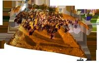
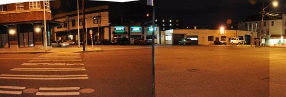
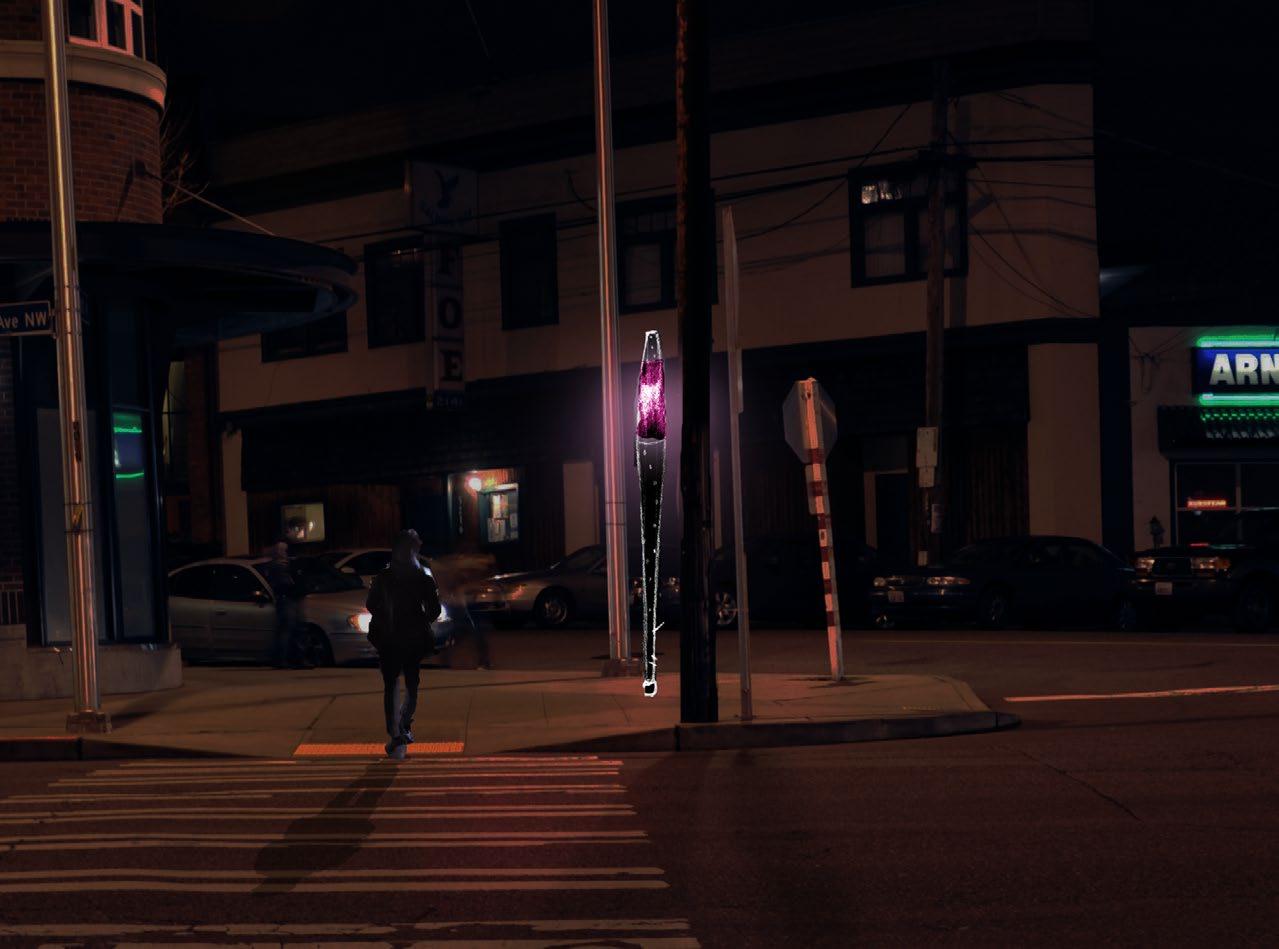
In the late afternoon of a semi-dry February Sunday one year ago, I staked a claim to a window seat at Seattle Coffee Works, arranged my coffee, croissant, journal and notes on the history of transportation landscapes in early 1900s Seattle and Ballard before me, and barely stirred from my seat for several hours. The window of this particular coffee shop looks out over the busy intersection
of NW Market Street, Leary Way NW, and Bergen Plaza. Being in the heart of the Ballard commercial and historic district, the intersection on that afternoon was nearly as heavily trafficked by pedestrians as by automobiles. Shoppers carried bags of baked goods and locally made condiments from the farmers’ market a block away, friends stopped for coffee, parents pushed strollers to the architecturally dramatic Ballard Library, seniors purchased movie tickets, couples browsed book and art
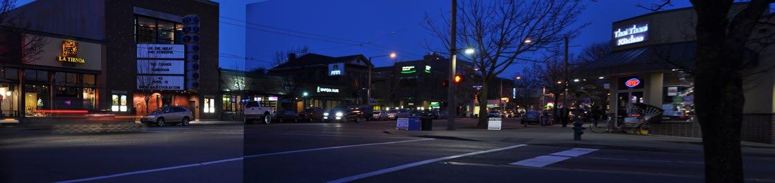
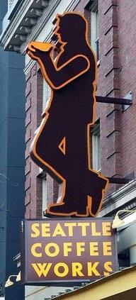
shops, and animated groups went into the Thai and Vietnamese restaurants on the other side of the street. I stayed past 3 p.m.: the farmers market had closed. The coffee shop was crowded; a few individuals sat at tables outside, seemingly content to chat in the 40-plus degree weather with hands wrapped around warm drink containers. I stayed past 4 p.m.: sunset was still an hour away, but the cloud cover and approaching dusk had already made the interior lighting seem noticeably brighter. I stayed past 5 p.m., and the changes in the scene shifted rapidly. Although there were still plenty of pedestrians on the street, the coffee shop had quieted some, and there no more readers or chatters in the chairs outside. The distinctive neon man of the Seattle Coffee Works sign, designed by Seattle-based Western Neon, lifted his orange coffee mug in a toast to the night. Streetlamps, neon signs, and shop windows glowed up and down the street, and the white lights of the trees along Ballard Avenue marked the appropriate pathways along streets that were still populated. At 5:30, the transition to darkness was complete, and I stepped outside into a new scene from the one I had left three hours prior.
It struck me that what came after this hour of transition is somewhat neglected in landscape theory. The hours after dark but long before bed (or after bed but before sunrise) are of tremendous value to us: they are the hours of leisure, of festivity, socializing, of pursuing the arts and interests outside of our school and work day lives, but also of retreat, wariness, of the physical transition between workplace and personal places. Yet there was little I had learned in my studies that addressed how we experience in dark the public spaces and pedestrian paths that we generally think of
as being in light. A few safety principles, yes; an occasional pretty night time rendering; not much more. For comprising such a large portion of our waking hours for so much of the year, the night seems quite underrepresented. Many designers (although not all) seem to design as if not much use of landscapes will occur at night time, that discomfort, safety and the perceived lack of it, and reduced visibility make most nighttime landscapes into no-man’s (and even more so, no-woman’s)-land. Yet urban nightscapes have plenty to attract us: when I walked back onto the changed street, I saw differently. Colors had changed, my attention was directed by the placement of lights, and the vintage and custom neon signs of Ballard drew my gaze more than the enormous sculptures of Bergen Plaza.
How could these observations apply to landscapes of rail transportation, the ostensible topic of my thesis?
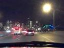
During my years in Japan, one of the greatest conveniences of urban life was the remarkably accessible and well-provisioned train stations. The stations, whether massive express train hubs in business districts or small neighborhood single-line stops, are active nearly as long as trains are running; a variety of daily errands can be accomplished within their complexes or on their peripheries; and pedestrian corridors known as shotengai, lined with goods and services, radiate out from stations, all of which makes train stations places where nearly everyone spends some time whether they are catching a train or not. The stations serve as meeting places for friends and business contacts, gateways to festive events, and places to grab a cheap meal or groceries on one’s way home. Some of these characteristics were undoubtedly due to particular Japanese planning and development conditions, but the point is that comfortable, intuitive access to the station made riding the train a natural and desirable choice, even on the darkest, coldest nights. Valuable evening and night time hours were easy to utilize for place-dependent activities. Public spaces remained active (and therefore safer) when they were close to transit. I have observed a similar pattern in other cities with strong public transit systems: in Chicago, New York, and Copenhagen, for example, successful transit locations are frequently in close proximity to successful public spaces.
A ride does not begin with stepping onto the transit vehicle. It begins with the path of access to that vehicle. It begins with the decision to make one’s way to the point of stepping onto the train or bus. At no time do there appear to be more obstacles to making such a decision than during winter darkness, and therefore that is when the landscape architecture and urban design of the route can do the most to help make that decision easier.
The goal of this thesis is to take one interesting neighborhood location and demonstrate how, working within Seattle’s climate and culture, qualities inspired by other places and by Seattle itself can bring a sense of warmth and humanity to the trek across a currently rather deserted-feeling space.
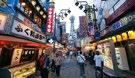
Urban nightscapes have the potential to be exciting, vibrant places—and in many places in the world, they are. It’s easy to point to Asian night markets, thriving night life districts in major
North American cities, the predominance of the evening hours for attending all kinds of arts and cultures events everywhere, bustling well-lit pedestrian avenues in California, plazas in Rome and Barcelona full of people cris-crossing the cobblestones until the early hours of the morning (and often beyond). These places have an atmospheric air of festivity at night, the darkness hardly slowing down the human activity from daytime.
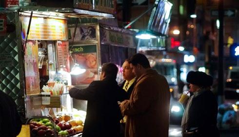
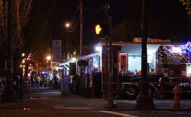
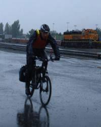
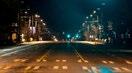
Of course, Seattle does not have the climate of Los Angeles, the late-night culture of Barcelona, or the density of Taipei or Tokyo. And indeed, Seattle is not world-renowned as a nightlife city, and it will probably never rival large subtropical cities in that regard, although it has a few energetic nighttime spots. Like any large city, Seattle has a range of public nighttime activities and amenities, commercial districts with eating and drinking establishments (the Ballard Historic District, for example), places for entertainment, and a maintained city-wide set of about 84,000 streetlamps1. Still, moving around Seattle at night is often a quiet experience. Most pedestrians and bike riders out and about night will probably be walking or riding through some areas of minimal street activity and low lighting. Perceptions of danger, actual danger, and various psychological effects of navigating an urban environment at night will probably be familiar to most Seattle residents who have sbeen out and about outside of daytime and bright summer evenings.
In spite of the length of time that Seattle spends in the dark, many valuable urban spaces are unutilized. Although some designers do good nighttime work, most public spaces and landscapes are designed mainly for use and interaction in sunny, warm conditions, the easiest situation in which to plan a landscape. Renderings of future spaces usually show people socializing and lingering in attractive daylight sans umbrellas or heavy coats. Yet a large percentage of our annual hours outside of a traditional daytime work and school schedule, hours when we might be enjoying or passing through such spaces, are spent under conditions that would benefit from careful nighttime and cold weather design.
Much potential in Seattle for a better nighttime experience is untapped. Temperatures in Seattle are fairly mild and the public is
1 Wright, Maury. “Seattle Conducts LED Street Light Testing and Hosts Symposium.”
generally supportive of arts- and pedestrian-oriented endeavors; neighborhood art walks, for example, continue year-round. Light art and nighttime winter events occur, but are strongly focused on the brief, traditional holiday season, such as the Green Lake Pathway of Lights community-driven event and the Redmond Lights festival, both in early/mid-December. Lighting technology is becoming cheaper and more environmentally efficient; the 31,00041,000 LED lights installed in Seattle streetlamps as of 20132 have been even more successful than anticipated. While the association of nightlife with increased noise, rowdiness, and bad behavior may exist, there are far more kinds of people who could benefit from well-considered night spaces than there are troublemakers — night-shift workers, regular workers, travelers with a plane to catch, senior individuals with reduced vision and navigation abilities, and so on.
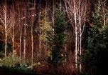
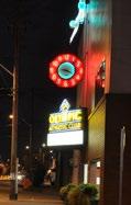
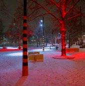
In fact, there are positive aspects to Seattle’s long winter nights. Daytime is beautiful, but night is beautiful too. There is poetry in the darkness, and the contrast with the evening conditions makes the flare of a fire, a light installation, or a glowing interior far more powerful. The darkness encourages the light. Even the rain has a positive effect on Seattle’s aesthetics: more classic neon, a highly skilled but sometimes-maligned art form, has survived in Seattle than in most North American cities, and neon art is still being created in Seattle. Could it be because the wet streets reflect the neon back into the air and down the road, creating a uniquely urban, immersive effect?
This is an important time to be thinking about access to transit at nighttime. Seattle is currently in a transit-expanding phase. Its light rail system is under construction, with several new stations set to be opening within the next 10 years. While the future of further transit construction is ever uncertain, there is popular support and grassroots organizations, such as Seattle Subway, working towards continued expansion and creation of new lines for high-capacity, grade-separated transit.
Seattleites on a standard daytime work schedule are commuting in the darkness of northern latitudes for a significant portion of the year. If public transit investments in Seattle are to be
2 “The Success of a City at Night | Crosscut.com.”
successful, and indeed if ridership is anticipated to grow, provisions must be made to ensure not only the safety and comfort of the people passing through stations and stops at night, but to make those points of access to transit
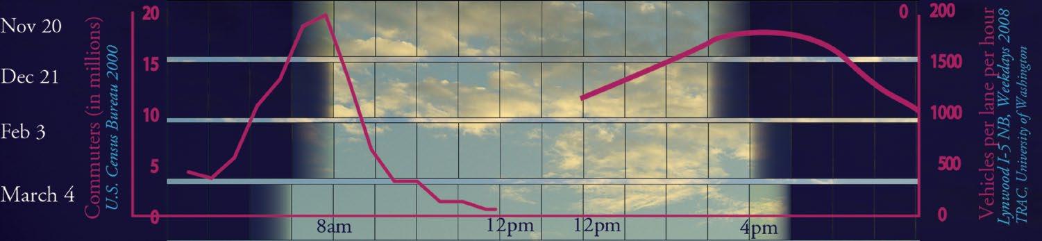
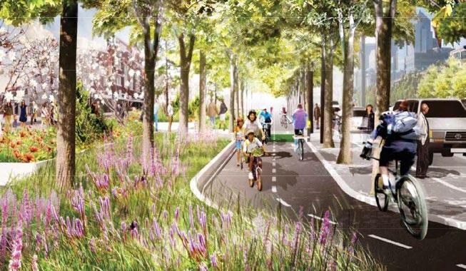
Figure 1-6. A cheery Seattle outdoor rendering / The experience of a dark Seattle winter. Images courtesy of Waterfront Seattle and Examiner.com
themselves attractive to access and use at all hours.
It is no secret that Seattle in the winter months does not experience an abundance of natural light: cities in the Puget Sound region make up 100% of the 15 cities in the U.S. with the lowest amount of sunlight per year3. As seen in Figure 1-5, the peak commute times between November and February – a full third of the year – fall in the dark or near-dark. By March, the daylight hours are considerably longer, but a substantial portion of workers are still commuting in pre-dawn and post-sunset murk.
Idealistic summery renderings are not wrong, but they are irrelevant to such a large portion of the year that only showing such utopias is taking the easy way out in design. A realistic design approach starts with acknowledging the range of conditions in which the site can be expected to be experienced. The climate receives few daylight hours between November and March; numerous sources report rates of Seasonal Affect Disorder as about 10% at this latitude. With the dimness of the overcast daylight hours in the maritime Pacific Northwest, the result is that
3 “Top 101 Cities with the Lowest Average Sunshine Amount (population 50,000+).”
Seattle receives the lowest light levels in winter of any major city in the continental U.S.
In dark, wet, cold conditions, people are moving quickly, with huddled body language. They are not interested in lingering on seating or contributing to a framed ambience by strolling about leisurely with a friend. Our dominant informationgathering sense is hindered after daylight hours. With the increased darkness and decreased enthusiasm for pedestrianism, perceived safety issues arising out of visibility difficulties and lack of human presence on the street take on greater significance. The lack of street interest—little activity or visual stimulation— on bleak days, or even moderate ones, is another hindrance to vibrant pedestrian activity. Yet encouraging carless transportation by encouraging pedestrians and bicyclists is possible: Scandinavian countries have even less light than we do, being further north, and have managed to maintain good public spaces through which to access transportation throughout the year.
The themes of this thesis will be arranged around four major concepts important to understand regarding our experience of the urban nightscape. These four concepts, or elements, can be pictured as a pile of blankets, referencing our need for warmth and comfort at night, that make up our multilayered sensory and psychological perceptions of after dark hours.
The top blanket on the pile, this is a positive outcome of a well-designed (or fortuitous) combination of lower elements. We can spend our leisure hours enjoying the creativity and company of others in a myriad of ways, one of the great dimensions of urban life. Night time in the public sphere is the prime time for holding festivals, events, and performances, for gathering at bars, cafes, and restaurants, for parties, for entertainment, for relaxation, for pursuing one’s own interests and skills.
Technology + physics
This blanket contains the technical know-how and artistic inspiration for lighting and light art. To make a successful night environment, we need some understanding of basic physics, materials, and information on the creation of structures both complicated and digital, and simple and lowtech.
Safety + sustainability
What happens when an urban environment interacts with the night? The first consideration, when contemplating a trip in the darkness, is usually to do with personal safety, both physical (senses are impaired) and social (the intentions of others). In addition, our attempts to carve out a space of light from the original darkness has ecological implications, in our use of energy and in the effect our nightless nights have on light-sensitive plant and animal species.
Mystery & darkness
Here is the poetic and philosophical underpinning of all the later, cultural and technical layers piled on top of the night. Before the modern city, before crime studies, before the advances in lighting technology, before the concerts and cafes and illuminated facades, it was dark at night. What about our perception of the urban night is still responding to this blanket? What does the darkness represent to us?
Arts + Social + Festivity
Technology + Physics
Safety + Sustainability
Mystery + Darkness
Typologies & Site
Characteristics
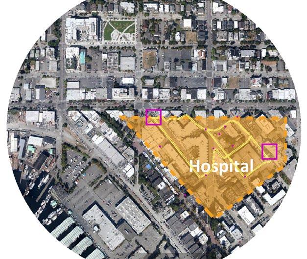
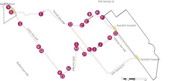
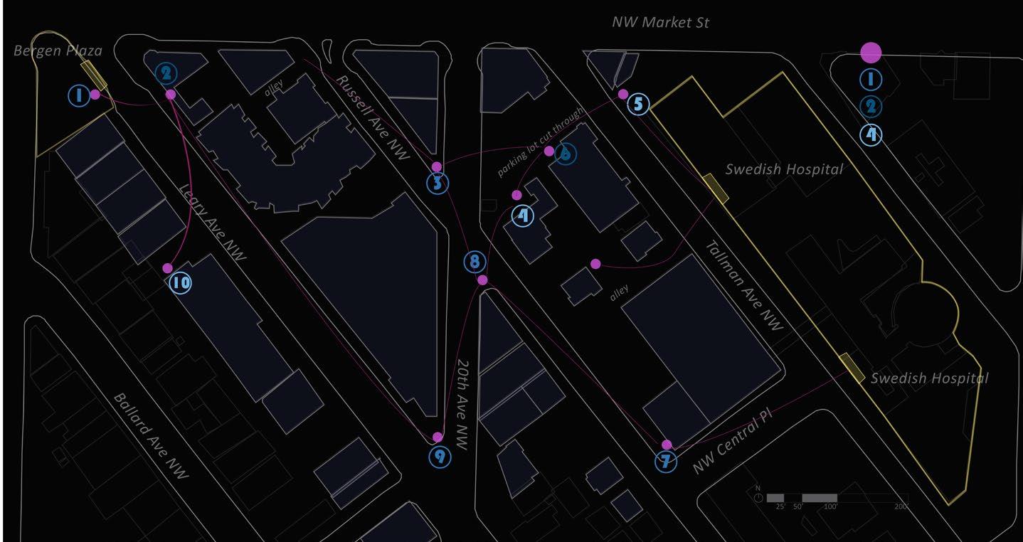
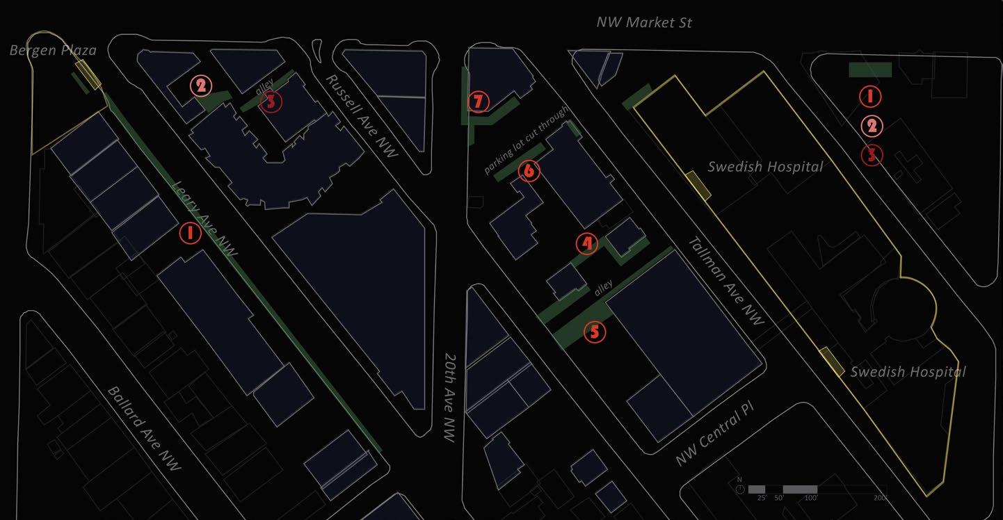
The Lan[d]tern site is a subdistrict of Ballard, Seattle, adjacent to the historic and nightlife district that runs along Ballard Avenue. The study takes as its starting point the intersection of Market and Leary, which is a busy, welllit and pedestrianized intersection that could in the future see the addition of a high-capacity transit line, such as a streetcar or underground light rail. The study observes the potential for multiple routes that would connecting a hypothetical station at this intersection to Swedish Hospital a quarter mile away. The hospital is an important source of employment in the area and has a need for good evening access for its night shift workers and guests.
Lighting Typology
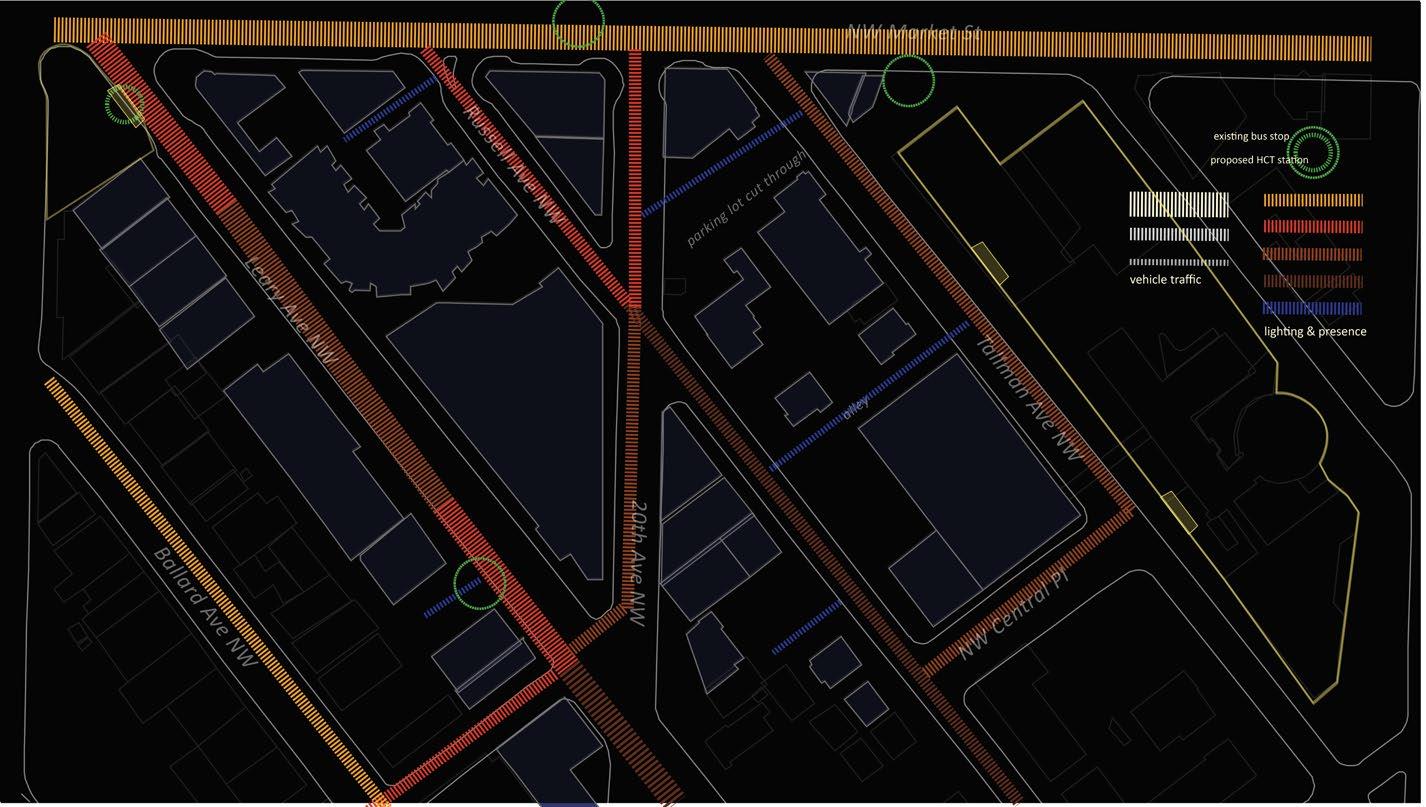
The following chart is a summary of the different categories of lighting that I have drawn from the precedent studies and from observations on site. Not all of them are necessarily source materials for design, but they are all experienced for their own qualities and in interaction with other light sources and materials, creating a shifting dynamic of light effects for passing pedestrians and cyclists.
Table 5-1. Light typology: existing and potential sources
Interior
Interior/exterior
Light from inside private buildings: offices, commercial, institutional, residential
Storefronts, shops, restaurants, kiosks, food carts
Overhead/ Security
Moving
Festive/Temporary
Security lights, municipal street lights, building exterior lights, marquees, spotlights
Car lights, reflective material on pedestrians/cyclists, flashlights, motion-activated lights, beacons
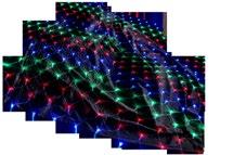
Christmas lights, lanterns, fireworks


Landscape
Projected
Objects
Underfoot
Spotlights on features (plants, water), lights set among planted areas
Architectural lights, backlights, film
Art installations, signage, glowing objects
Embedded in pavement, footlights along paths
Natural/Ambient
Human presence, visibility
Human presence, visibility, refuge, nourishment, security, warmth
Visibility, security
Visibility
Mystery/intrigue, play, natural surveillance
Mystery/intrigue, nature
Mystery/intrigue, play, information
Mystery/intrigue, play, landmark
Moon, stars, reflected light from clouds
Visiblity, mystery/intrigue, navigation
Visibility, mystery/intrigue, nature
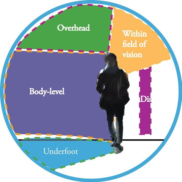
The body zone represents the spatial relationship of the pedestrian figure to lighting (and other) interventions made at night. Will interventions be primarily aimed to be perceived as immersive, distant, adjacent to one’s body? Heights and proximity affect the intensity and effect of lights, and being able to sort lighting into human-scaled positioning will assist in predicting and determining the interaction with a given piece.
This chart summarizes the conceptual construction of my thinking for this project. The first column, Intervention Types, represents the core of the typology I develop further in the design chapter: how interventions relate to their spatial context in terms of routes. The second column, Strategies, shows some key ways that those intervention types can take form, and the third column, Goals, shows the objectives of those strategies (grouped by key concept). Strategies later represented in the design proposals are highlighted in yellow.
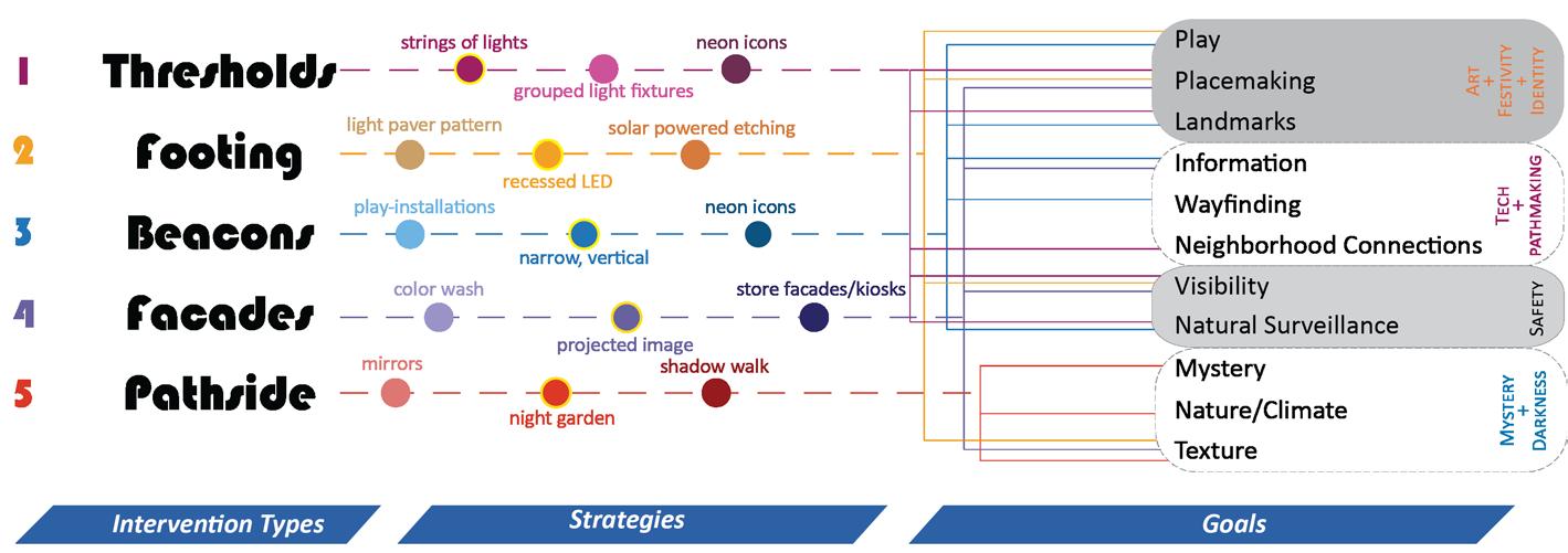
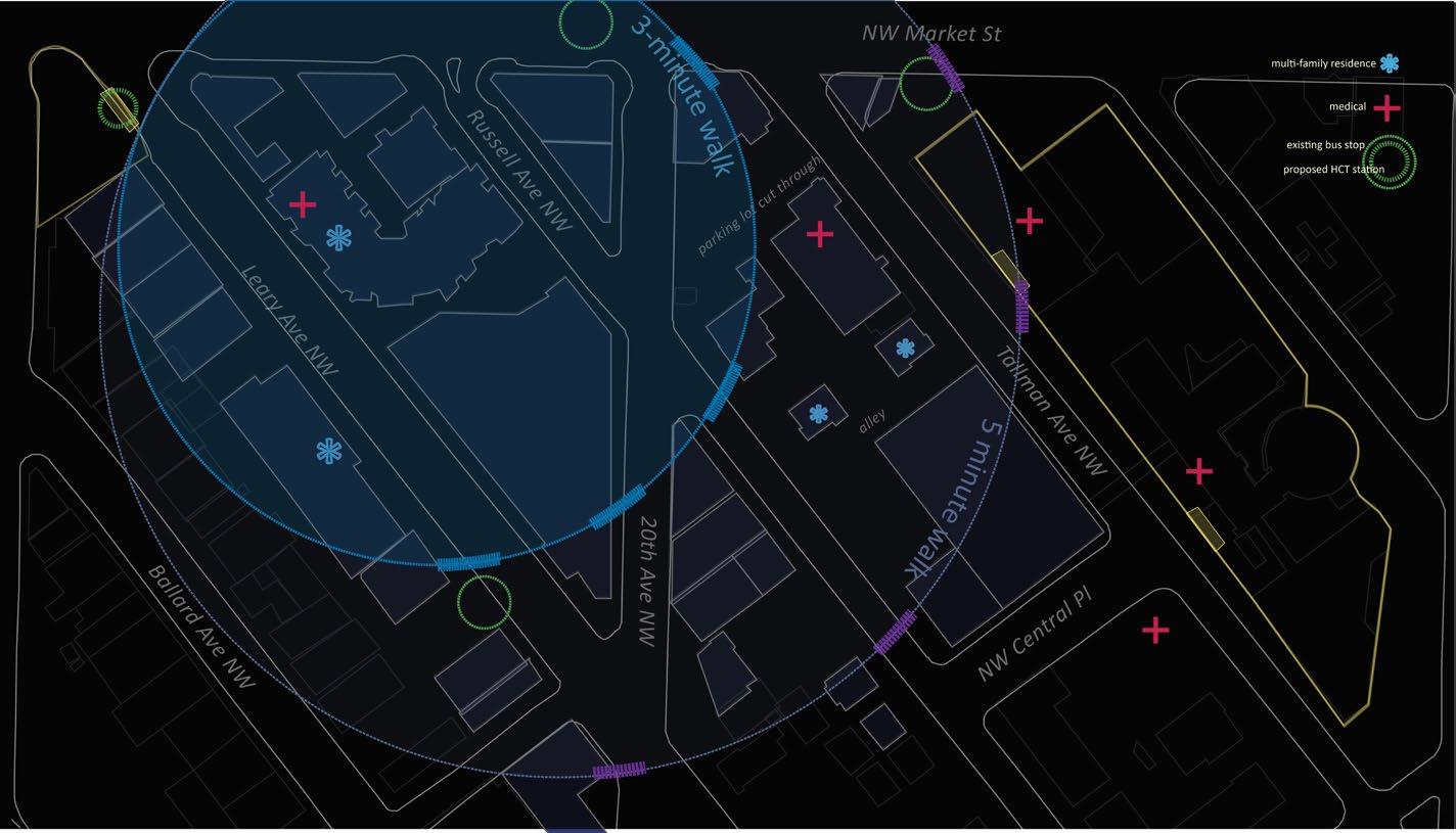
Figure 5-70. Location of site in relation to North Seattle; existing circulation modes; and propozsed station location
Proposed HCT station
Plaza
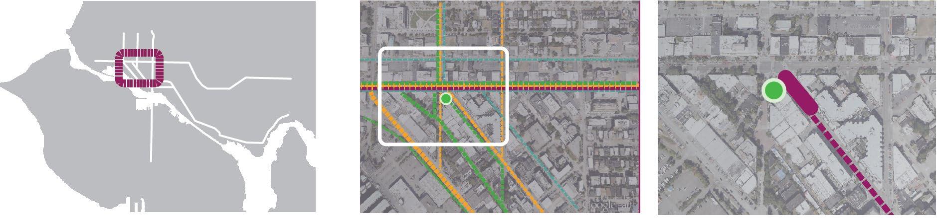
The site is bordered by neighborhood arterials Market Street and Leary Avenue. As shown in the center diagram of Figure 5-70, busses run along both Market Street and Leary. There are many pedestrians along Market Street and Ballard Avenue to the southwest of the intersection. Automobile traffic moves fastest along Market and Leary, and Leary is less commercial with fewer pedestrians. The side streets of Russell, Tallman, and Barnes run parallel to Leary and have much lighter, slower traffic.
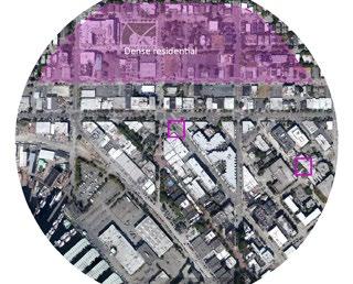
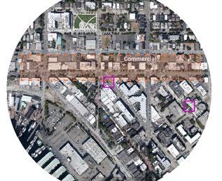
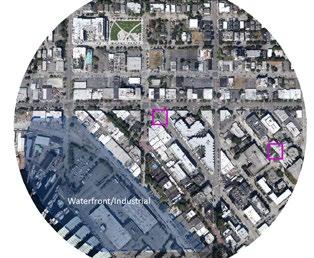
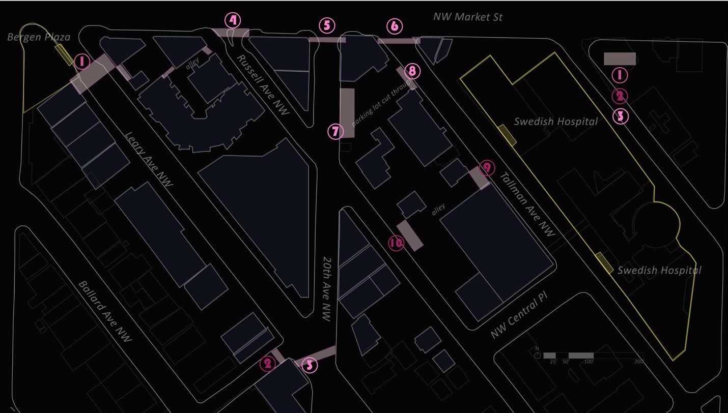
Five subdistricts were identified within a quarter-mile radius of Bergen Plaza as a part of analyzing connections to the site and determining adjacent neighborhood characteristics.
A dense residential zone north of the plaza/intersection contains numerous multifamily residences of varying construction dates, as well as the Ballard Commons.
A commercial zone runs along Market Street and a block or two north of it. Along Market Street are numerous restaurants, cafes, coffee shops, a cinema, and moderately upscale and trendy retail shops. A block north of Market includes more service-oriented businesses and a couple of large chain retail stores, as well as the popular Ballard Library.
The historic district follows Ballard Avenue southeast from Market Street to its intersection with 22nd Avenue. This district is aesthetically appealing, nightlife oriented, and
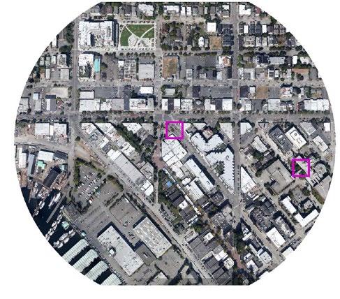
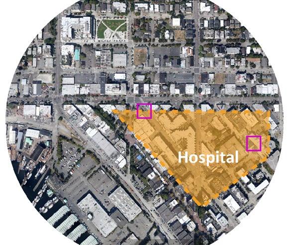
Hospital subdistrict. Location of hospital emergency entrance and Bergen Plaza marked by the squares.
5-71. Subdistricts identified around station.
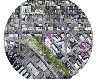
attracts many pedestrians, although street crossings and sidewalks are not entirely consistent along the length of the street.
The waterfront and industrial district, following and southwest of Shilshole Drive, is a living part of Ballard’s history as a center of industry and marine-oriented operations. A short, privately owned train line still operates along the waterfront, although most of its original length is decommissioned and can be partially followed on foot. The marina is in active use, and although there is public access to the water it is unmarked and located between a defunct restaurant building, a large parking lot, and a light industrial facility. The industrial district could also be expanded to include the area southeast of the hospital district, where the blocks contain various warehouses, small production facilities, parking lots, and car-oriented businesses.
The hospital subdistrict will be the focus of the remainder of this analysis due to its 24-hour cycle and therefore particular need for good nighttime access to transit. Lessons from the hospital district and recommendations for its nighttime design can and should be adapted to the other subdistricts.
The hospital subdistrict is a blend of zoning and land uses: there are commercial uses in its northwest corner, multifamily residences and medical offices surrounding the hospital, a large parking garage, and light industrial uses at the southern/eastern borders.
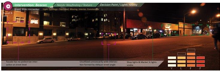
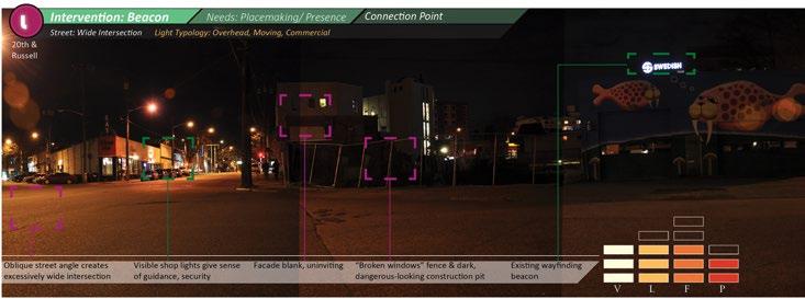
The organization of the streets feels non-intuitive. The streets meet at oblique angles, and although a couple of streets run northsouth, the northwest-southeast angle of the three parallel streets at the center of the district makes navigation and wayfinding confusing. There are numerous cut-throughs where people prefer to move directly east or west rather than zigzag around corners.
The area is currently undergoing heavy construction in several spots, which may have something to do with some of the wide gaps in lighting, particularly along Russell Street. The area gives a general impression of being dark and unfinished, given its odd
street arrangement and ad hoc cut-throughs, demolished lots, and its adjacency to low-density, low-nighttime-use light industrial areas. The buildings are from a mix of construction periods but are generally younger than the attractive historical brick buildings along Ballard Avenue. Few buildings stand out as anything but generic.
Market Street, the northern border of the district, is the most immediately appealing path. It is well lit and lined with a number of businesses that are open late and provide a consistent number of other pedestrians to keep the street feeling monitored. It is less in need of interventions than the other streets, although it acts as a gateway to the district: most streets leading off Market into the hospital subdistrict feel like they are crossing a threshold into a distinctly different area. This could make it an interesting starting point for establishing a district identity via artistic light installations.
A senior care living facility is located on the southwest side of Leary. Combined with the numerous medical offices and, of course, the hospital, specific user needs regarding potentially low levels of mobility and reduced eyesight should be strongly considered in design.
There are several main takeaways from this quick oversight of the neighborhood layout. The street angles make wayfinding difficult. There is lots of potential in underutilized spaces for interesting
pedestrian experiences. The district is currently dark and not entirely safe feeling, enough so that some people feel hesitant walking there (or, anecdotally observed, warn others against going there alone). Due to land use types and visibility issues, the district feels somewhat isolated from its immediate surroundings, having no clear connection to either the waterfront or historic districts nearby.


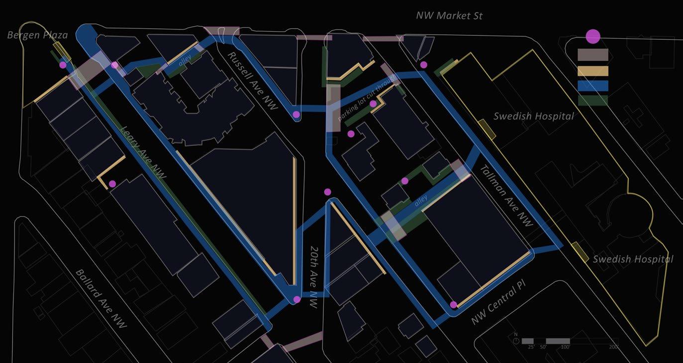
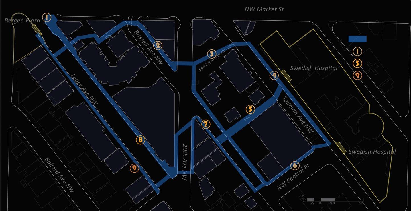
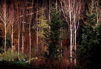
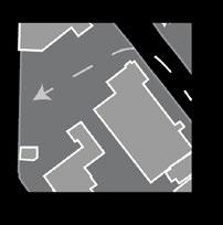
Intervention elements will be considered in relation to the street typology context of each location. Figure 8 shows a sample of 5 streets and intersections found on the site that represent different street typologies.
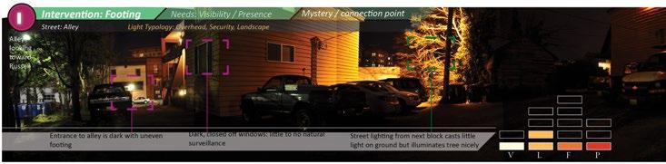
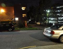
1. Residential alley. This path is the narrowest and quietest of the types. Not even marked on official maps or GIS data, this is primarily used as access for residents. However, due to the location of this particular alley directly across from Swedish hospital and its through connection to Russell Street, it does get foot traffic from non-residents.
A small alley like this is unlikely to have municipal lighting although there may be some privately installed security lights or wall scones. The alley may feel unsafe or uninviting but is also a valuable access point. Interventions should be subtle to avoid unwanted foot traffic and glare/ light pollution.
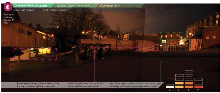
2. Parking lot cut-through. This path is quite wide, although not designed with pedestrian use in mind. Parking lots are frequently associated with low levels of natural surveillance and a sense of isolation. Like the residential alley, this particular one’s convenient location between the hospital and Russell Street probably contributed to the numerous pedestrians observed cutting through it. The relative openness of this space and primarily day-based usage of it by automobiles makes it a strong candidate for
site-based light art installations.
3. Wide, under-used intersections. The oblique angle of streets in this district leads to swaths of unnecessarily asphalted street space. Lighting is generally even and up to municipal code, provided by cobra head street lights, LED pedestrian lights, and private wall sconces. Visibility is less good, tending towards blind corners. The bits of leftover space on the street utilized by neither cars nor pedestrians could be an opportunity for placement of small night gardens.
4. Street with sidewalks but no crosswalks or lane division. Street width is about 32’ on these small neighborhood capillary streets. Traffic flow is low and speeds are slow, but street lighting is also patchy, alternating between completely missing and being overdosed with privately installed security lights. Sidewalks are narrow, and parked cars obscure vision. Combined with blind corners and unfenestrated facades, some of these streets feel quite deterrent to pedestrian activity. Where they are lined with residences, as in the southern on-site portion of Russell, their function is a little bit like a living room; they should provide a sense of security, belonging, and warmth. A warm but not sodium-yellow light temperature can help get the atmosphere right. Light lumens should be subtle and light direction should be controlled, to avoid light
5. Street with sidewalks, crosswalks, 2-4 lanes with painted lane dividers. This is a traffic artery, with street width of about 55’. Traffic is fast and pedestrians must cross at designated crosswalks. Street lights are cobra heads, designed for traffic. There may be some glare/contrast issues. On this particular site, there is a partial second level of lighting more geared toward pedestrian assistance. Sidewalks are wide, even and maintained. Some building facades are partially illuminated and some have interior light but there are also a number of completely dark facades after business hours.
Using the aforementioned street typologies, I categorized each street or portion of the pedestrian network as either a major arterial street, a side street, or an alley/parking lot cut through. I also noted several parking lots or alleys that are open to streets on one side but for some reason (usually a fence) are not connected to the street on the other side. I further noted whether each
portion of the network is well illuminated and has pedestrian presence (natural surveillance), is less lit and busy but still feels safe, is lit but lacks a strong sense of natural surveillance, is partially lit but has gaps in lighting, or is downright dark with little natural surveillance.
This map shows the current (as of Jan 2014) state of transition from high-pressure sodium street lamps to LED lighting, with its cooler white tones but more accurate color illumination. These lights have mostly been installed along Market Street, but one is also present at the corner of Russell Avenue and 20th Avenue NW. The map also makes an effort to represent light from commercial
facades, fluorescent lighting from wall-mounted security lights and parking garages, and various other light sources such as landscape lighting and the trees draped with strings of small white LED bulbs along Ballard and Market. However, the area is changing rapidly, and over the course of the year that I was observing this site, numerous buildings were removed and new ones constructed,
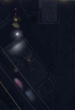
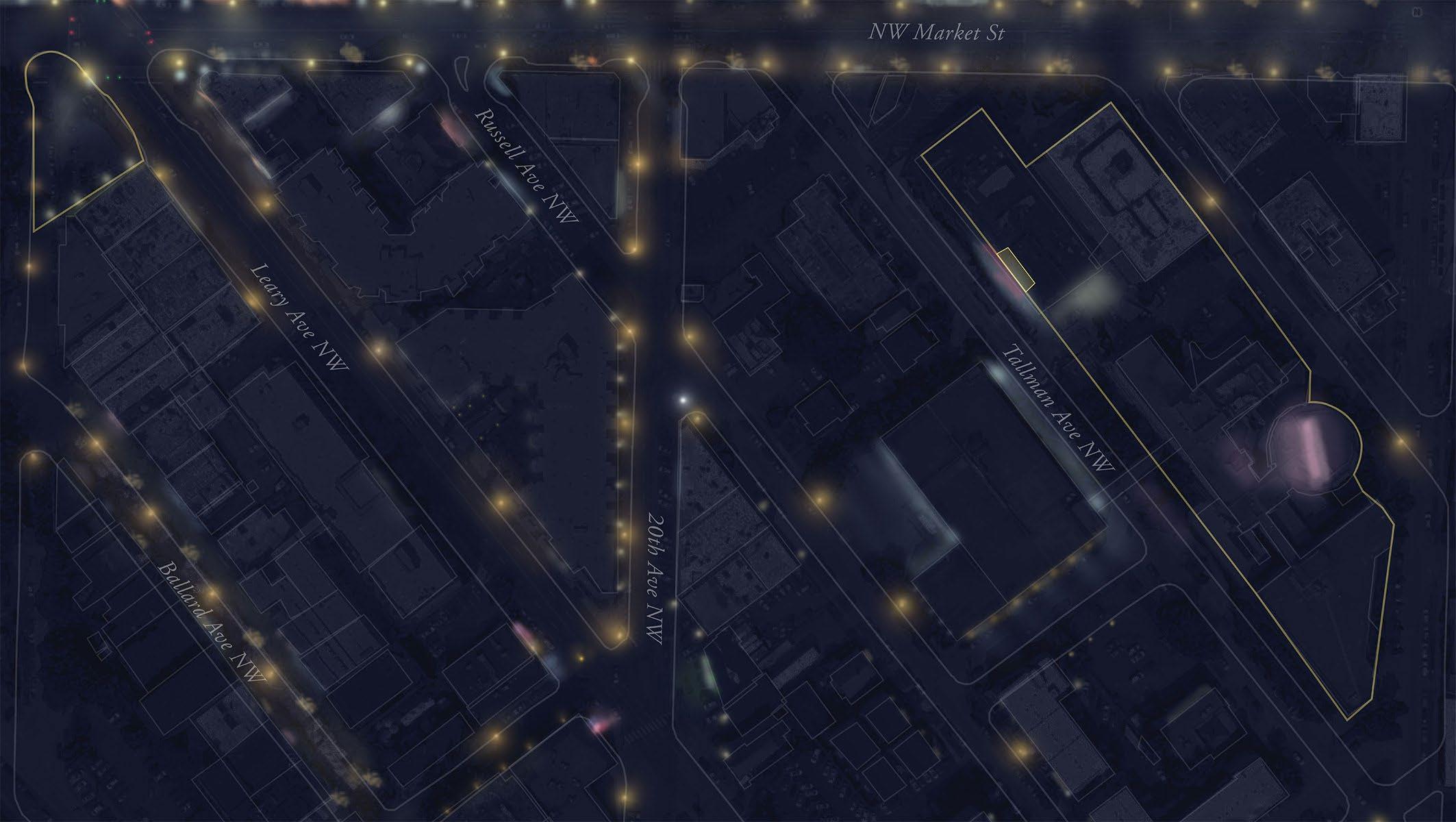
Figure 5-77. Figure 27. Existing light conditions in Ballard: Placement and temperature. (See Appendix for light survey details)
Iset out to analyze the district through a systematic approach to gathering photos and applying a matrix of criteria to the resulting images.
I first determined the routes I would follow to gather data by highlighting the potential network of paths between the two primary destination/origin points. I deliberately left the main pedestrian path, Market Street, out of the main analysis focus since it is already functioning fairly well as it is. I chose to concentrate my efforts on expanding the pedestrian network via the shortcuts, alleys, and side streets that already see some
pedestrian use, but could benefit most from interventions aimed at increasing visibility, wayfinding, and safety.
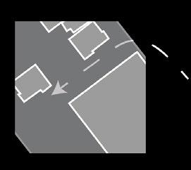
In the interest of doing justice to each route, I further narrowed the routes down to two alternate paths and made observations at numerous points along each path. Light but regular pedestrian activity was observed along each of these paths. The northern route cuts through a parking lot along the edge of a construction pit and currently rejoins Market just one block before the intersection with Leary.
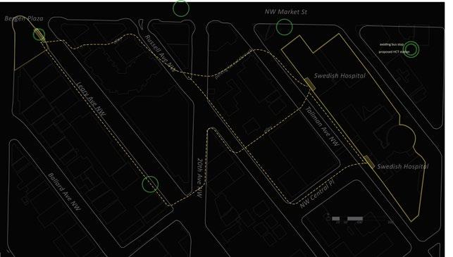
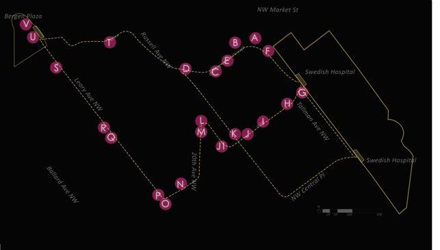
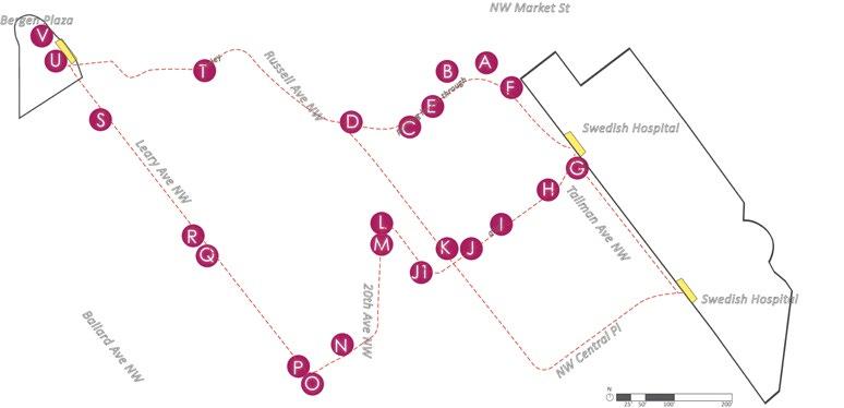
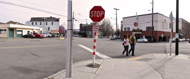
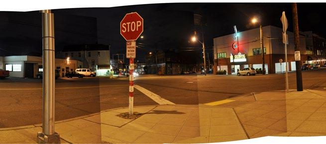
Figure 5-80. Point N (intersection of Leary and 20th) at 3:30 in the afternoon and 7:30 at night, early March 2013.
Photo collages by day and night
For the photo documentation site visit, I spent a half day on location. I documented each point along the paths by day and again by night. I then overlaid the stitched-together photos with analysis of conditions and proposals for intervention types.
My criteria for analyzing the site were drawn from the technical and psychological knowledge of lighting gained from the literature review.
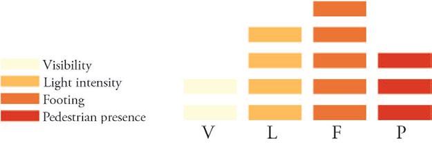
Figure 5-81. Evaluating site conditions. 1 bar = poorest conditions found on site / 5 bars = top conditions found on site
I started with a subjective evaluation of the visibility, light intensity, footing, and pedestrian presence at each point relative to the general conditions of the site as a whole.
Visibility/wayfinding (V)
What’s visible from a distance? The station/hospital/landmarks? Are there any blind corners or other visual obstructions? Does the path seem clear or is the street system confusing?
Light intensity (L)
Without making a technical measured analysis of lux or reflectivity of adjacent materials, I made a subjective estimate of available light at each point relative to the site’s general luminous intensity.
Footing (F)
Is the footing even, with a clear, wide space to walk? Does the sidewalk or road edge seem rough? Are there areas to cross the street?
Pedestrian presence (P)
Since much of the perception of street safety comes from the presence of eyes on the street, it was important to observe whether the area seemed inhabited; if people seemed to be moving with purpose, or lingering oddly; if people seemed wary or relaxed.
I also analyzed the photos according to perceived needs (e.g. wayfinding, social presence), street typology, lighting typology, key aspects of the site point (e.g. if a decision about direction needs to be made, if orienting features are visible from the point) and then proposed an intervention element (based on the components diagram shown in the previous chapter) that would be suitable for that site.
Finally, I called attention to particular qualities of each point and the nature of the light sources nearby. I made notes of gaps in the lighting or any corners or streets that looked particularly unappealing/ ominous, whether due to low illumination or harsh security lights making the surrounding area difficult to decipher. I also noted which lights contribute something particularly interesting or unappealing to the streetscape.
Figure 5-82. Analyzing site points according to typology & need
negative points positive points
District identity
This area currently feels generic, with flat asphalt ground surfaces, little vegetation, and blocky concrete and low-rise structures. It also feels detached from the nearby lively historic district and the working waterfront. The design should use elements to highlight the blocks’, and Ballard’s, particular historic and textural character while also creating a fresher sense of place. Placemaking can begin at the borders to the subdistrict, where it connects with other neighborhoods with their own distinct characteristics, as discussed in the site analysis. Since the district includes a hospital with only a tiny scrap of green space attached to it, a major goal beyond safety and visiblity should be to make the area feel
softer and gently playful.

Provide a network of paths, as explained in the path design section of the lit review. The paths will be hierarchically related to each other in the sense that pedestrians would immediately perceive some as being larger and more-travelled than others. In this site, Market Street would represent the highest level of the hierarchy; as the best lit and most commercialized street in the district, it is also likely to be the default choice of most people navigating from with the site boundaries to the transit station. Paths along different levels of the hierarchy, however, are all valuable in building a multiplicity of route options and increasing the diversity of interesting points along the hospital-to-train route. Create
clear, easy to find paths between the station and destination points in the neighborhood, and create a “sequential visual experience.” 1
Perceived safety, particularly from crime, is crucial to nighttime pedestrian activity. The proposed design needs to address urban safety through lighting, social presence of other people, and enlivening neglectedlooking spaces.
Related to safety through social presence of other people, the proposed design should encourage positive social interactions through festivity, playfulness, and interactive elements.
Acknowledge and preserve the atmosphere of night

The goal is not to flood the landscape with bright light. This site is completely covered with urban development, so there is little reference to nature on site while there is a consistent need for safe illumination. However, some room should be carved out for engaging other nighttime senses and acknowledging the presence of night species and natural lighting from the sky.
1 Phillips, The Lit Environment.
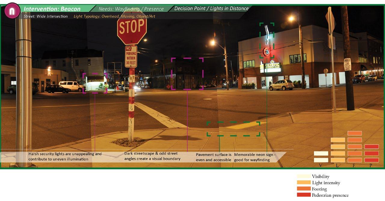
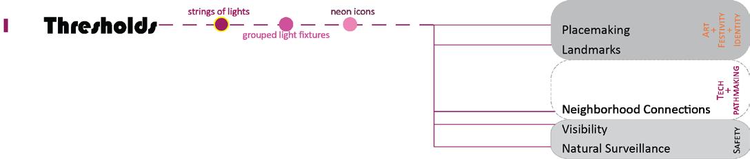
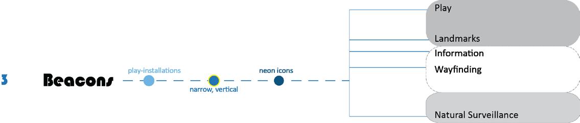
Beacons
Thresholds
Facades
Path surfaces
Path sides
Map of suggested opportunity areas
Thresholds are located at points where the character of the street or land use changes abruptly. The entrance to a threshold may be a gap between buildings, or it may be a strange intersection, or it may be a juxtaposition between street and land use qualities.
Thresholds mark a line where one feels oneself to be in a different kind of space on either side. The transition between spaces may
be jarring, to the degree where passerby choose not to cross the threshold or subconsciously perceive the transition as a kind of barrier that it doesn’t occur to them to cross (by not noticing a efficient cut through in an alleyway, for example). Establishing a consistent, recognizable threshold strategy helps to connect the pieces of the neighborhood together.
Body Zone: Overhead or at body height Light Intensity: Medium Structure: Free standing object, signage, or lighting attached to/ protruding from a facade Aspects: Wayfinding, Placemaking Goals met: District identity, Path network is reinforced, Use of individual objects rather than bright lights clarifies available routes without generating much light pollution Features: Iconic markers, colorful neon art, symbols & historical references to neighborhood character and culture
6-87. Current threshold: featureless. Photos by author
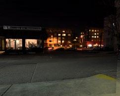
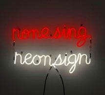
Figure 6-86. Strings of lights and neon icons can mark thresholds. Nonesing/Neonsign, Bruce Naumann. Photo courtesy of guggenheim.org.
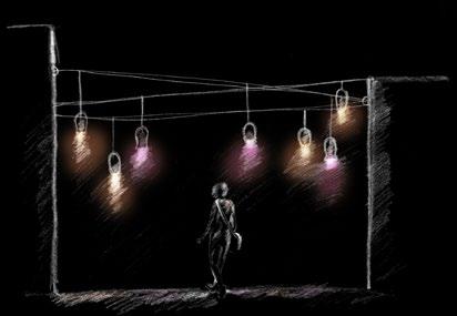
Figure 6-88. Grouping a number of colored lights and hanging them in semi-traditional fixtures creates a sense of homeyness: warmth and intimacy.
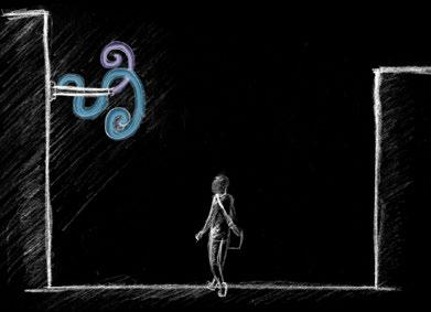
Figure 6-89. A symbol, abstract or representational, made from an interesting self-illuminated material, can mark entrances to any of these threshold types.
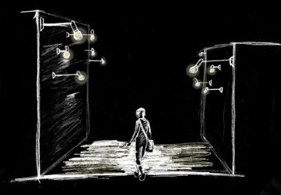
Figure 6-90. Hall of light. An abundance of low level lights is playful and creates even illumination at narrow or dark thresholds.
Threshold areas
Grouped fixtures
colored squid lamps
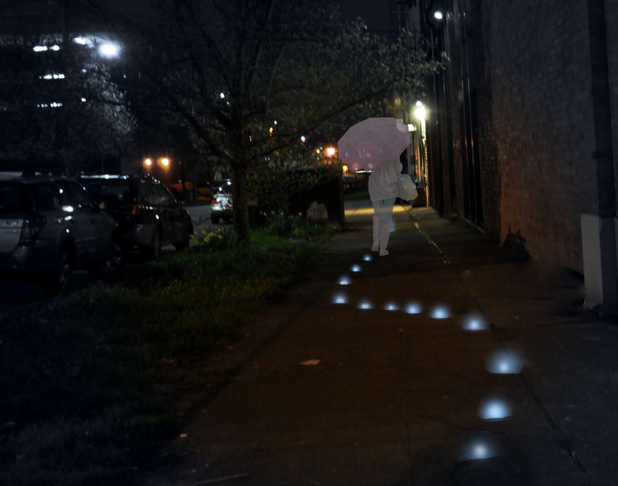
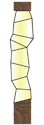
threshold / string of lights + footing / pattern
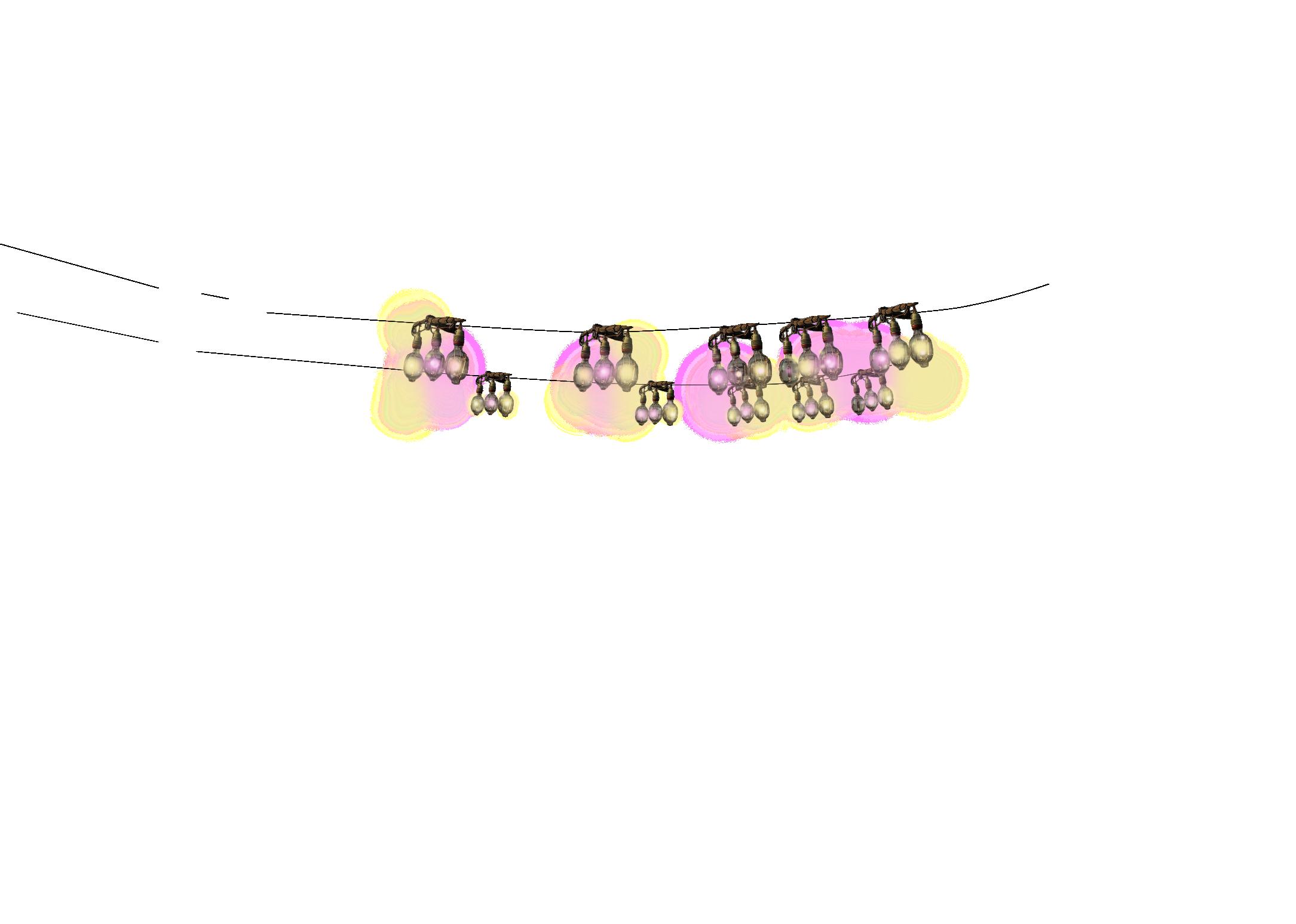
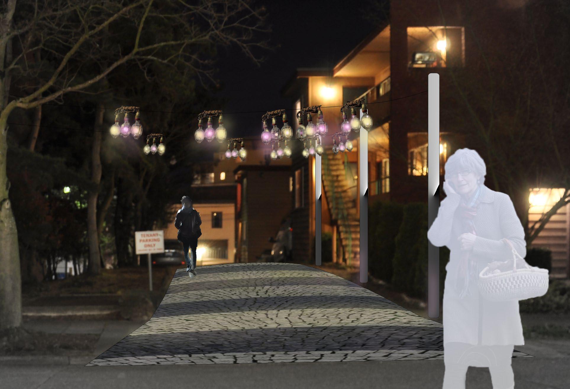
Space: Residential alley. Quiet, but directly facing hospital entrance.
Scale: Overhead; lights positioned 10-12’ above ground and stretching about 15’ across the alley. / Underfoot, 15’ wide strip of pavers.
Materials: Steel poles, thin steel cable, replica squid fishing lamps, LED bulbs in pale red/yellow. / Stone pavers.
Function: Create a welcoming but not overly bright passageway and increase safety for residents.
Light: Create a warm, gently colorful, soft effect that will interact with the light paving.

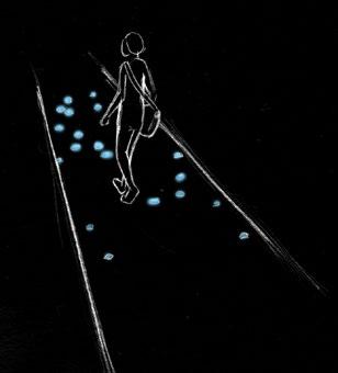
Interventions made to the surface of the ground itself increase pedestrian interest and confidence of following the right route. Lights placed at this level can be kept quite low. Helping to keep
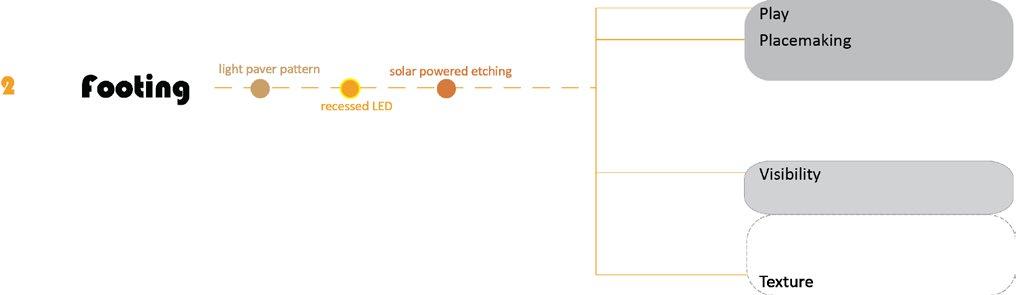
Body Zone: Underfoot Light Intensity: Low Structure: Ground – sidewalk, asphalt, dirt, pavers, pavement Aspects: Safety, Texture Goals met: Route is defined, Visibility for footing is improved, light levels are kept low, mixture of low-tech and interactive design Features: LED technology, movement-responsive design, textural materials, repeatable patterns, ecologically friendly
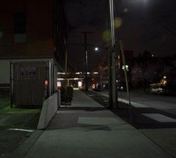
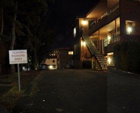
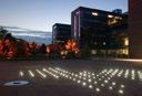
Figure 6-97. Sidewalks are mostly even and easy to navigate, but a few are narrow and not particularly well illuminated. Some brick pavers have been installed by Market Street. Photos by author.
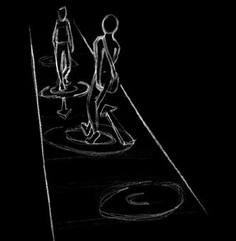
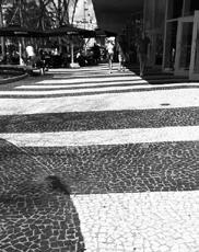
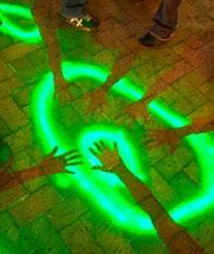
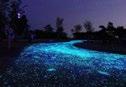
Figure 6-98. Solar-powered lighting, interesting ground level patterns, and interactive movement tracking make for a more dynamic pedestrian experience. Left to right, photos courtesy of envirogadget.com; land8. com; dancorson.com the path clear and easily visible is an important consideration in a district containing a senior care facility and a hospital.
with white pavers/tiles

footing / recessed LED + facade / recessed LED
Space: Semi-commercial side street with little night activity. Parking garage & empty lots visible.
Scale: Underfoot and body level; individual lights are small; length of the installation is a few hundred feet.
Materials: Motion sensors, recessed & covered plates in pavement and brick, LED bulbs.
Function: Human-motion-activated installation appears to follow the pedestrian. Lights flick on several feet ahead and fade off a few seconds behind a walker.
Light: Playful, subtle; the cool temperature and evanescent behavior is reminiscent of marine bioluminescence.
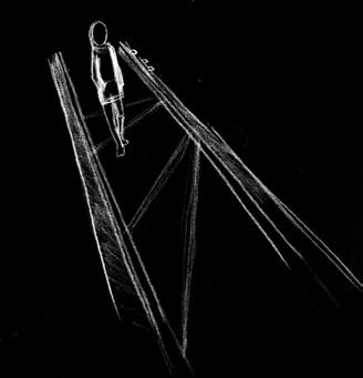
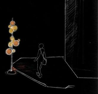
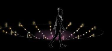
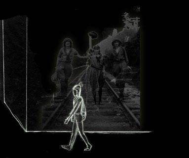
Beacons are consistent interventions that are repeated, perhaps with slight variations, throughout the district to mark a route. Like going on a treasure hunt, arriving at each beacon will position the pedestrian to view the next beacon in the sequence. Beacons are especially valuable at intersections or at points where a turn needs to be made but a final destination is not yet clearly visible.
Beacons could take on many forms: freestanding vertical beacons with a narrow footprint can be placed on sidewalks at blind corners to reassure pedestrians that they are going in the right direction; neon icons attached to facades could become familiar checkpoints along a routine walk to and from the station.
Body Zone: Distance, Body Level Light Intensity: Moderately High Structure: Metal, neon, LED Aspects: Safety, Texture Goals met: Route is defined for users, Visibility is improved while keeping light levels low, mixture of low-tech and interactive design Features: LED technology, movement-responsive design, textural materials, efficient energy usage
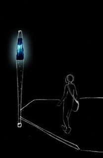


beacon / narrow & vertical
Space: Wide intersection in a commercial area, a little over a block away from the proposed station.
Scale: The beacon is a little more than head height, about 8’-9’, with a narrow base enabling it to be placed on a wide sidewalk.
Materials: Metal, plastic, LED.
Function: Identifies the intersection as an important turning point to access the station or the hospital and provides an estimate of train arrival times.
Light: Boldly colored, medium brightness; should be seen from a distance of 2 blocks. Light shifts through a range of brightness intensity to indicate length of time until the next train or streetcar arrives.
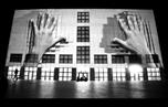
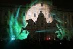
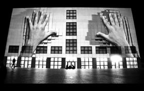
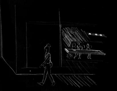
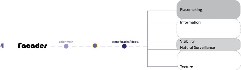
Facade interventions act on structural surfaces that are currently not engaging the pedestrian experience, either through lack of features/windows or by having darkened windows that give no sense of natural surveillance. Facade interventions take advantage of large unfeatured surfaces by treating them as a canvas for colorful architectural illumination or for still image/video projections.
The facade category also addresses activating windows and openings. Efficient, low-intensity illuminations may be used for storefront or other ground-level window displays. Activity into the evening hours can be encouraged through permitting extended operation or through space sharing schemes.
Body Zone: Field of Vision, Distance Light Intensity: Low Structure: Projections & LED lights on building surfaces, Interior spaces illuminated and activated Aspects: Placemaking, Texture, Natural Surveillance Goals met: Site is animated; unengaging facades become a canvas for artistic display, Open businesses increase social presence Features: LED and digital projection technology, movement, interior activity engaging the exterior
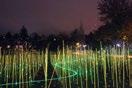
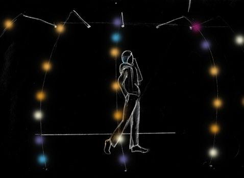
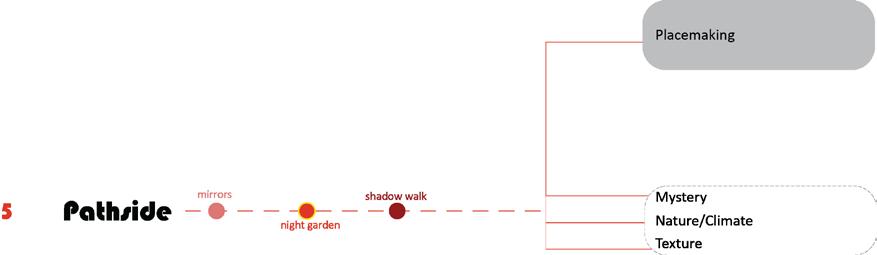
Pathside interventions are placed alongside the actual walking surface. They may be contained within their own space, or they may interact with the walking surface by casting lights or shadows. These interventions focus on texture and immersive or playful lighting installations. Night gardens emphasize use of strongly textured foliage, interesting branching structures, pale foliage and blooms, and well placed uplighting and accent lighting. Immersive
structures play with the effects of colored shadows cast by limitedspectrum lights, with patterned and overlapping effects.
Body Zone: Underfoot, Body Level Light Intensity: Low-moderate Structure: Varies --vegetation, landscape lighting fixtures, wood & metal structures Aspects: Mystery, Nature, Texture, Placemaking Goals met: Route is defined for users, Visibility is improved while keeping light levels low, mixture of low-tech and interactive design Features: LED technology, movement-responsive design, textural materials, ecologically friendly
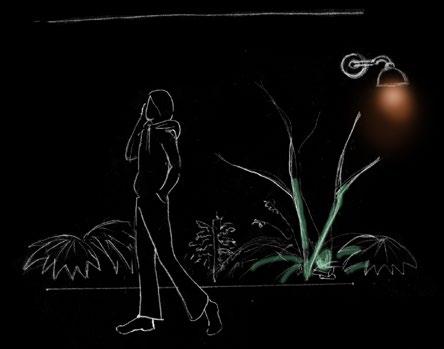
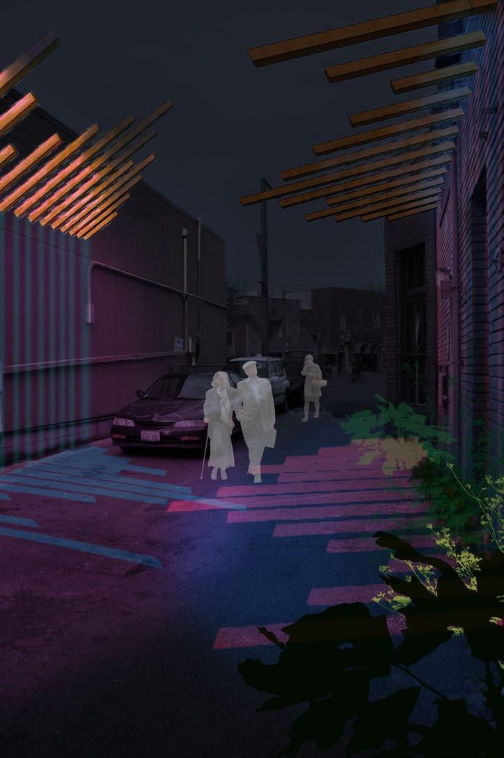
shadow walk pathside / shadow walk
Space: Alley bordered by blank facades in a commercial area. Space is narrow but a potential connector.
Scale: Overhead, about 10-12’ high, casting light and shadow patterns underfoot. At least half the length of the alley.
Materials: Wood, colored lights.
Function: Replaces high powered security lights with a more mysterious but still bright form of lighting.
Light: Playful, colorful, informative; the two colors of lights aimed at the wood beams create interesting overlaps and extensions of colored shadows that shift as you walk along them.