
International Planning Studies
ISSN: (Print) (Online) Journal homepage: https://www.tandfonline.com/loi/cips20
Evaluating scenarios for twenty-first-century Australian settlement planning: a Delphi study with planning experts
Julian Bolleter, Nicole Edwards, Robert Freestone, David Nichols & Paula Hooper
To cite this article: Julian Bolleter, Nicole Edwards, Robert Freestone, David Nichols & Paula Hooper (2022): Evaluating scenarios for twenty-first-century Australian settlement planning: a Delphi study with planning experts, International Planning Studies, DOI: 10.1080/13563475.2022.2042213
To link to this article: https://doi.org/10.1080/13563475.2022.2042213

Published online: 13 Mar 2022.

Submit your article to this journal


View related articles
View Crossmark data
Full Terms & Conditions of access and use can be found at https://www.tandfonline.com/action/journalInformation?journalCode=cips20

INTERNATIONAL PLANNING STUDIES
https://doi.org/10.1080/13563475.2022.2042213
Evaluating scenarios for twenty-first-century Australian settlement planning: a Delphi study with planning experts
Julian Bolleter a, Nicole Edwardsa, Robert Freestone b, David Nicholsc and Paula Hooper a
aAustralian Urban Design Research Centre, University of Western Australia, Perth, Australia; bSchool of Built Environment, University of New South Wales, Sydney, Australia; cMelbourne School of Design, Faculty of Architecture Building and Planning, University of Melbourne, Melbourne, Australia
ABSTRACT
This paper presents findings from a national survey of Australian planning experts examining future settlement patterns and locations at the continental scale. Collective judgement supported efforts to achieve population decentralisation and favoured three possible scenarios –Satellite Cities, Boosted Secondary Capital Cities, and East West Megaregions. The findings on preferred settlement pattern scenarios can inform future efforts to develop a national urban policy for Australia. This case study can also serve as a reference point to the over 160 countries worldwide that are developing, implementing, or evaluating national urban policies in support of global urban agendas.
Introduction
KEYWORDS
Australian cities; national urban policy; new cities
Urbanisation is amongst this century’s most transformative trends: demographers predict that by 2050 the world’s urban population will almost double (United Nations General Assembly 2016). Realising multi-dimensional and multi-scalar challenges for national states, particularly in the Global South, has seen a renaissance of advocacy and engagement in national policies guiding urban and regional decision-making. These policies1 define a strategic, long-term and shared vision for national urban development (OECD et al. 2021a) recognised as instruments implementing global urban agendas, notably the United Nations’s Sustainable Development Goals (United Nations Conference on Housing and Sustainable Urban Development 2017). These include Goal 11 ‘Cities and Communities,’ Goal 8, ‘Decent Work and Economic Growth’, Goal 9 ‘Industry, Innovation and Infrastructure’ and Goal 13 ‘Climate Action’ (OECD, UN Habitat, & UNOPS 2021b).
Australia is a microcosm of global urbanisation challenges in confronting the long-run pressures of population growth and change. The Australian Bureau of Statistics’ (ABS) median 2101 population projection is over 50 million: doubling the current population (Australian Bureau of Statistics 2017). Recent Australian Government reports and initiatives acknowledge the importance and impacts of population growth and migration settings. In 2019, a research and advisory Centre for Population was established within its Treasury Portfolio. The interconnections between population and settlement are appreciated (Australian Government 2020), but an empirical research foundation is yet to emerge.
This paper presents findings from a national scale, online Delphi-method survey of Australian planning experts who considered, rated, and commented on possible future settlement pattern © 2022 Informa UK Limited, trading as Taylor & Francis Group
CONTACT Julian Bolleter Julian.bolleter@uwa.edu.au Australian Urban Design Research Centre, University of Western Australia, Level 2, 1002 Hay Street, Perth, WA 6000, Australia
scenarios. The Plan My Australia survey gathered responses from nearly 300 professionals from urban planning and cognate fields. The immediate background to settlement planning in Australia prefaces our description of the survey parameters, subsequent presentation of the major findings, and discussion of implications.
Existing planning for population growth
Regional-scale planning frameworks exist for managing population growth at Australia’s Federal and State Government levels. The Federal Government has been periodically involved at the highest level of planning for Australian cities and regions since the 1940s, across vicissitudes of enthusiasm as state and local governments retained statutory leadership. It has generally steered clear of command intervention except for an ill-fated mid-1970s growth centres policy (Bolleter et al. 2021). Nonetheless, there has been a recent foci shift with a turn to population distribution, inter-regional connectivity, infrastructure and smart cities and suburbs (Dodson 2013). In early 2019, the Government released a national population strategy for an ‘optimal settlement pattern’ (albeit undefined) through coordinated investment in cities and regions. This strategy was formalised in late 2019 through a scaffolding of programmes and initiatives collectively ‘busting congestion in our cities, increasing connectivity between cities and regions through fast rail, and upgrading major transport routes’ (Australian Government 2019, 7). A National Population and Planning Framework has emerged as a set of collaborative protocols to enhance national, state, and local ‘understanding of populations, population change and its implications’.
This latter document lacks a strong spatial framework, and ‘settlement outcomes’ were relegated for consideration to an unspecific forum of ‘senior officials’ (Coalition of Australian Governments 2019). Nevertheless, the population-settlement-planning nexus’ significance is highlighted throughout national government inquiries and reports. For example, planning to populate north of the Tropic of Capricorn (23.5′ S latitude) has concerned the Joint Select Committee on Northern Australia, and a 2015 Government white paper espouses a generally pro-development stance, supporting the conceptualisation of the north as rich in economic bounty and opportunity (Australian Government 2015): ‘Development will require many more people living in the north … We need to lay the foundations for rapid population growth [and] a trajectory to reach a population of four to five million by 2060′ (Australian Government 2015, 4). Given northern Australia’s current population of 1,300,000 this represents an almost four-fold increase.
In late 2016, a Senate Committee recommended selected non-metropolitan centres to augment their roles as ‘capitals’ or ‘hubs’ for regions underpinned by ‘aspirational’ targets of population inmigration from the capitals (Australian Government 2016, 56). A wide-ranging 2018 House of Representative Committee inquiry explored the Commonwealth’s role in city development (Australian Government 2018). It canvassed problems and policy options impacting metropolitan, regional and rural Australia through submissions and public hearings, producing nearly 40 recommendations. The first and most critical of these was to ‘develop a national plan of settlement, providing a national vision for our cities and regions across the next fifty years,’ considering issues of population and employment growth and change, sustainable development, and connectivity to, within and between regions. In mid-2020, the Australian Government accepted this recommendation ‘in principle’ (Australian Government 2020). However, a supplementary recommendation for an executive office of chief national planner was rejected, the government seemingly preferring to work through existing collaborative mechanisms across the three governmental tiers. State Governments are chiefly responsible for their jurisdictions’ population growth planning and plans for regional development.
While several federal, state and local government planning frameworks exist for managing population growth and related settlement patterns, such planning is typically low in capacity to absorb population growth. Moreover, it is short term, spatially fragmented and often lacks extensive community engagement. Given this and the growth pressures which Australia will face this century, the
2 J. BOLLETER ET AL.
benefits of a national urban policy identifying areas of highest urbanisation capacity are readily apparent. Government investments enabling infrastructure, land development and employment generation in alliances with the private sector could incentivise populations to relocate to these areas.
The Planning Institute of Australia has advocated for a national urban policy and made a compelling submission to the 2018 House of Representatives Committee inquiry on cities. Its ‘tipping point’ manifesto called for a better ‘line of sight’ coordinating proactive interventions and responses across all government levels from the top down. Such a strategy would express longterm growth, productivity and liveability outcomes for Australia’s cities, states and regions and supply a grounded spatial context for a national population policy (Planning Institute of Australia 2018). However, while these deliberations have moved the discussion towards the desirability of national settlement planning processes, the actual normative content remains to be fleshed out. This paper contributes to the debate, considering a range of macro settlement strategies of the kind that might underpin a future national urban policy. The research question structuring our enquiry is:
What are potentially the most sustainable, liveable, productive, and feasible settlement patterns for accommodating a projected doubling of Australia’s population by 2101?
Methods
The Plan My Australia project applied the Delphi method to congregate opinions and develop consensus among experts. Delphi solicits and aggregates informed judgments from a group of experts. It enables structured communication among people, allowing them to tackle a complex problem effectively (Perveen, Kamruzzaman, and Yigitcanlar 2017). Moreover, it facilitates assemblage through an iterative survey process rather than face-to-face meetings. Furthermore, the Delphi method ensures experts’ anonymity, thus obviating much of the bias inherent in the dominance of a single group or person (Perveen, Kamruzzaman, and Yigitcanlar 2017). Our rationale for selecting the Delphi method relates to its widespread application in evaluating planning and policy scenarios in regional planning (Morgan, Pelissero, and England 1979), urban planning (Hudson, Galloway, and Kaufman 1979) and sustainable urban growth management (Perveen, Kamruzzaman, and Yigitcanlar 2017). While our approach builds on such prior examples, it is novel in its continental scale of application.
Recruitment and sampling
For present purposes, the Delphi method, a non-random purposive sampling technique (Kelley et al. 2003), was used to identify planners who had demonstrated expertise in the theory and practice of urban studies and management. The Planning Institute of Australia initially approached members and provided a comprehensive list of those who agreed to participate. These and others known to the authors (n = 579) were contacted via email and provided a link to the Survey Monkey ‘Plan My Australia: Experts Survey’ Stage 1. The survey was live between February and April 2020. Survey responses (n = 283) were exported to SPSS Statistics, version 26 for analysis. A response rate of 48% was achieved.
The Stage 1 survey presented ten settlement pattern scenarios, spatially located in areas identified as suitable to help accomodate a projected population of over 50 million in Australia by the start of the 22nd century. Respondents were asked to rate each scenario against four assessment domains. Stage 1 survey respondents were asked to provide comments on Likert scale questions to identify the pros and cons of each scenario and considerations for implementation. Responses were exported to NVivo, and comments categorised into broad themes and then sub-categories. Responses were edited for grammar or clarity – for example, split and categorised when respondents presented more than one theme or category.
INTERNATIONAL PLANNING STUDIES 3
The Stage 1 survey subsequently asked respondents to (1) indicate their top three distribution preferences and (2) indicate their least favourite preferences. In addition, respondent demographic data (such as gender, age, occupation, place of residence and birthplace) were also collected.
The data were cleaned to provide consistency among categories, and Likert scale responses were converted to numerical values, i.e. strongly disagree ( 2), disagree ( 1), neutral (0), agree (1) and strongly agree (2) to allow for ‘domain’ and ‘scenario’ scores to be calculated. Domain scores were calculated by summing the scores provided by each respondent. Domain scores were then examined and categorised: (1) Strongly Disagree a scenario was feasible ( 566 > 283); (2) Disagree scenario was feasible ( 283 > 0); (3) Agree scenario is feasible (0 > 283) and; (4) Strongly Agree scenario is feasible (283 > 566). Domain scores for each settlement pattern scenario were summed to give an overall scenario score, and distribution scenarios ranked according to the overall score.
Respondents who completed Stage 1 of the Plan My Australia Survey (n = 283) were invited, by email, three weeks later to complete Stage 2. This email link presented results from Stage 1 (i.e. settlement pattern scenario preferences listed in rank order) and asked respondents to review the overall ratings and confirm or re-visit their top three preferences. The survey link remained open for two weeks, and stage 2 responses (n = 159) achieved a response rate of 56%.
First preferences (for the settlement pattern scenarios) were allocated three points, second preferences two points, and third preferences one point. Preference scores were determined by summing the scores provided by each respondent, and the scenarios were ranked in order of highest preference to allow a direct comparison with the rank order determined in Stage 1.
Study measures – settlement scenarios
The national population forecast for 2101 employed in the Plan My Australia survey was 53 million, which is the Australian Bureau of Statistics’ mid-range Series B projection (Australian Bureau of Statistics 2013). This projection represents a 28 million increase in the current population. The ten settlement pattern scenarios presumed that half of this increase would augment the populations of existing Australian cities and towns. As such, the critical question asked was where the remaining 14 million Australians should live.
Ahead of the preferential judgments solicited, the survey instrument presented a series of national maps to provide a consistent, base level of knowledge in four main subject categories representing constraints or opportunities for urbanisation.
For the ‘climate’ theme, the projected (2090) average annual maximum temperature and average annual rainfall were mapped (Australian Government 2017). Meteorological data were derived from the Intergovernmental Panel on Climate Change (IPCC) RCP 8.5 climate projection (Intergovernmental Panel on Climate Change 2014) and the ACCESS1.0 model co-developed through collaboration between CSIRO and the Bureau of Meteorology (BOM) (Australian Government 2017). Additionally, a map of cyclone incidence (per annum) was shown (Bureau of Meteorology 2020) (Figure 1).
Under the ‘natural and cultural heritage’ theme, maps of biodiversity, conservation reserves (Geoscience Australia 2018) and Native Title Determination areas were presented (National Native Title Tribunal 2019) (Figure 2). The ‘infrastructure’ theme supplied maps of existing rail lines, major roads and piped water supplies (Geoscience Australia 2018) (Figure 3). Finally, the ‘productivity’ theme presented maps showing median household income (Australian Bureau of Statistics 2016), mineral resources and state capitals (i.e. Australia’s major employment nodes) (Kelly and Donegan 2015) (Figure 4).
Subsequently, the survey presented ten settlement pattern scenarios representing various possibilities canvassed in recent academic (Bolleter 2019; Bolleter and Weller 2013) and policy literature (Australian Government 2015, 2019; SGS Economics and Planning 2020). Given the scenarios’ geographic breadth and the need for assessment clarity, these were typically one-dimensional. The
4 J. BOLLETER ET AL.


intention was that such simplified scenarios would encourage reflection about respondents’ preferred settlement patterns, how those preferences might differ between individuals and the basis of those differences (Logg-Scarvell, Navis, and Patrick 2015). We clarified this in the survey
Figure 1. Mapping of climatic conditions. Figure 2. Mapping of natural and cultural heritage. Figure 3. Mapping of existing infrastructure.INTERNATIONAL PLANNING STUDIES 5
Figure 4. Mapping of factors relation to economic productivity.

introduction by stating, ‘Please be aware, while some scenarios are not currently plausible, they will still stimulate responses of value. We are looking for insights rather than a vote favouring a single scenario.’ Indeed, any future implementation would require multiple scenarios to be hybridised. The scenarios are briefly introduced below.
Boosted Capital Cities
Australia has amongst the highest levels of metropolitan primacy globally, and its primate cities are all state and territory capitals (Freestone 2013). This scenario extrapolated from this characteristic, presenting a scenario boosting these cities by 1.8 million people each by 2101 (Figure 5).
Boosted Secondary Capital Cities
Population growth in Australia’s largest state capitals, Melbourne and Sydney, is compounding issues of housing affordability and congestion (Kelly and Donegan 2015). This scenario responded to this reality, siphoning population growth to the remaining state and territory capitals and projected population increases by over 2 million people in each by 2101 (Figure 6). This scenario derives from current Federal Government planning to ease growth pressures in Sydney and Melbourne (Australian Government 2019).
Satellite Cities
In response to affordability and congestion issues in state capitals (Kelly and Donegan 2015), this scenario distributed population growth to 13 satellite cities, an enduring model of metropolitan population redistribution (Freestone 1982). Within the commuting distance of state capitals, these satellites increase by over 1 million people by 2101 (Figure 7). This scenario derives, in broad terms, from the principles of Federal government planning for ‘population, migration and better cities’(Australian Government 2019).
6 J. BOLLETER ET AL.
Figure 5. Boosted Capital Cities scenario locations.


East–West Megaregions
This scenario distributed population growth to 18 regional cities as another strategy to reduce pressure on the state capitals. Accordingly, this scenario increased the population of these cities
Figure 6. Boosted Secondary Capital Cities scenario locations.INTERNATIONAL PLANNING STUDIES 7
Figure 7. Satellite Cities scenario locations.

by over 750,000 people each and connected them to the state capitals by rail (Figure 8). This scenario derives from a 2013 model (Bolleter & Weller) and an early Federal Government proposal for High-Speed Rail (AECOM 2011).
Sea Change Cities
Australians continue to prize coastal amenity (Burnley and Murphy 2004), creating Bernard Salt’s ‘empty-island syndrome’ (Salt 2011). Accordingly, coastal property in Australia’s state capitals is often unaffordable. In response, this scenario distributed population growth to 25 sea-change cities and, in doing so, increased each city’s population by over 500,000 (Figure 9).
Southern Megaregions
Modelling suggests that southern Australia will be less affected by climate change than the remainder of the continent (Australian Government 2017). Accordingly, this scenario distributed population growth to 15 southern urban centres, growing by almost 1 million people each. In this scenario, centres were connected to the state capitals by regional rail and ferry links (Figure 10).
Northern Major Cities
Currently, Northern Australia, the gateway to Asia, constitutes 45% of Australia’s landmass but houses only 5% of its population. In response, this scenario boosted Broome, Darwin and Townsville by almost 5 million each by 2101 (Figure 11). This scenario was framed around current prodevelopment northern planning (Australian Government 2015).
Northern Regional Cities
A variation on the previous strategy, this scenario distributed the increased population across nine regional cities by over 1.5 million people apiece (Figure 12) to similarly reflect growth aspirations for northern Australia (Australian Government 2015).
8 J. BOLLETER ET AL.
Figure 8. East-West Megaregions scenario locations.

 Figure 9. Sea Change Cities scenario locations.
INTERNATIONAL PLANNING STUDIES 9
Figure 10. Southern Megaregions scenario locations
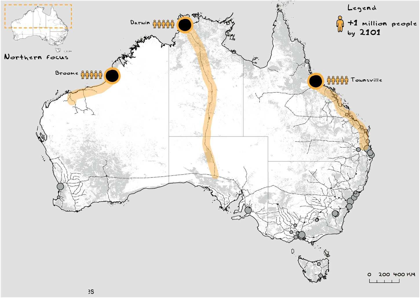
 Figure 11. Northern Major Cities scenario locations.
10 J. BOLLETER ET AL.
Figure 12. Northern Regional Cities scenario locations.

Eastern Megacities
Australia’s two biggest cities, Melbourne and Sydney, generate most of Australia’s Gross Domestic Product and attract most migrants (Kelly and Donegan 2015). This scenario extrapolated this pattern and hypothesised an increase by almost 7 million people each in Melbourne and Sydney by 2101 (Figure 13).
Western Cities
Currently, Western Australia comprises 33% of Australia’s landmass yet only 11% of its population. Accordingly, this scenario boosted seven cities along the west coast by over 2 million people each (Figure 14). The scenario derived from Western Australia’s current Royalties for Regions programme (Western Australian Planning Commission 2012).
The four assessment domains employed to evaluate the various settlement scenarios were sustainability, liveability, productivity and feasibility. The considerations underpinning each are indicated in Table 1. In developing these domains, we referenced Australia’s (now dated) Urban Design Protocol, a national framework for achieving a ‘productive, sustainable and liveable future’ by articulating a set of goals, objectives, and underlying principles to guide decision-making (Major Cities Unit 2011). We recognise that while these domains are listed separately, they are, to varying degrees, intertwined with each other.
Results
Demographic characteristics of the survey respondents are outlined in Table 2. Respondents were mostly male and relatively evenly distributed between 35–75 years old. Far fewer respondents were 25–34 years of age. Most respondents were Australian-born and residing in state capitals. States (South Australia and Tasmania excepted) were evenly represented, and territories (n = 2) were under-represented.
INTERNATIONAL PLANNING STUDIES 11
Figure 13. Eastern Megacities scenario locations.
Domain

Factors for consideration when rating each domain
Sustainability Does the proposal require substantial clearing of natural environments and biodiversity?
Does the proposal locate cities where they will require significant amounts of energy for cooling or heating?
Liveability Does the proposal expose future urban populations to uncomfortable climatic conditions? Does the proposal create megacities that typically have lower levels of liveability?
Productivity Does the proposal concentrate future urban populations in areas far from significant employment nodes (e.g. state capital cities, resource-rich areas?)
Feasibility Does the proposal require substantial investments in new infrastructure (e.g. new cities along upgraded regional rail links)?
Does the proposal require federal and state government coordination (e.g. chains of new cities crossing state borders)?’
Scenario preferences and commentaries
We now present the results of the survey in summary quantitative and more extended qualitative terms. Table 3 summarises the rank order of the settlement pattern scenarios. The rank order of the top two preferences did not change between Stages 1 and 2 of the survey. The preferred settlement pattern scenarios in Stage 2 were Satellite Cities, Boosted Secondary Capital Cities and East–West Megaregions.
Qualitative data obtained from respondents identified a range of factors associated with the pros and cons of each scenario. An interpretive summary of comments from the Stage 2 survey is provided below in rank order of preferences.
1. Satellite Cities
Our experts agreed that this highest-ranked scenario is potentially feasible, productive, liveable and sustainable. One respondent reasoned it was ‘the most realistic in attracting people to cities other than just the state capitals. These cities offer good proximity to the coast and access to nearby
Figure 14. Western Cities scenario locations. Table 1. Assessment domains and factors for consideration.12 J. BOLLETER ET AL.
Table 2. Demographic characteristics of survey respondents.
Demographic characteristic (n = 283) Number (%)
Gender
Male 171 (60.6)
Female 78 (27.7)
Age
25–34 24 (8.5)
35–44 59 (20.9)
45–54 66 (23.4)
55–64 52 (18.4)
65+ 52 (18.4)
Birthplace Australia 173 (61.3)
Canada 6 (2.1)
(1.1)
New Zealand
South Africa 7 (2.5)
United Kingdom 38 (14.4)
United States 8 (2.8)
Other 12 (4.2)
Occupation Architecture 7 (2.5)
(0.4)
Neighbourhood and urban renewal 2 (0.7) Place-making 3 (1.1) Planning law 3 (1.1) Regional and rural planning 32 (11.3)
Social and community-based planning 7 (2.5) Transport planning 9 (3.2) Urban design 17 (6.0) Urban development 15 (5.3) Urban planning 103 (36.5)
Other 47 (16.6)
Length of Australian residency
0–9 years 15 (5.3) 10–19 years 18 (6.4) 20+ years 221 (78.4)
Current state of residence
Australian Capital Territory 10 (3.5)
New South Wales 72 (25.5)
Northern Territory 1 (0.4)
Queensland 47 (16.6)
South Australia 13 (4.6)
Tasmania 6 (2.1)
Victoria 38 (13.4)
Western Australia 54 (21.4)
Overseas/Other
metropolitan areas’ such as would ‘enhance productivity.’ Consequently, respondents felt satellite cities could deliver ‘the lifestyle that many Australians aspire to.’ Generally, respondents felt this scenario would ‘relieve the growth pressures diminishing liveability in state capitals, yet also ‘strengthen existing communities.’
There was also agreement on feasibility. Respondents highlighted the ‘extensive experience garnered through the new towns movement on how to develop satellite cities’ arguing such ‘new development is easier and cheaper than retrofitting’ existing areas with increased density.
China 4 (1.4)
Germany 3 (1.1) India 3
10 (3.5)
11
1
Development Assessment 15 (5.3) Engineering 1 (0.4) Environmental planning and natural resources management
(3.9) Heritage and conservation
(0.4) Infrastructure and services planning 2 (0.7) Landscape architecture 5 Landscape planning 1 (0.4) Law 1
INTERNATIONAL PLANNING STUDIES 13
Table 3. Settlement pattern scenarios rank order.
RANK ORDER
RANK ORDER STAGE 1 STAGE 2
1. Satellite Cities
2. Boosted Secondary Capital Cities
3. Boosted Capital Cities
4. East-West Megaregions
5. Southern Megaregions
6. Sea Change Cities
7. Eastern Megacities
8. Northern Regional Cities
9. Northern Major Cities
10. Western Cities
1. Satellite Cities
2. Boosted Secondary Capital Cities
3. East-West Megaregions
4. Boosted Capital Cities
5. Sea Change Cities
6. Southern Megaregions
7. Northern Regional Cities
8. Northern Major Cities
9. Eastern Megacities
10. Western Cities
Despite a slew of positive comments associated with the Satellite Cities scenario, some warned it would, in time, ‘just result in sprawled out megacities’ suggesting ‘this is suburban sprawl under the guise of change.’ Further, some participants saw the Satellite Cities scenario as eroding the impetus for other regional opportunities.
Additionally, respondents believed delivery of the Satellite Cities scenario would require ‘some form of public/private partnership in securing the land and infrastructure funding necessary to implement development’ and that it ’would depend on holistic support in terms of infrastructure and jobs in the short term.’ Moreover, respondents felt the Satellite Cities scenario required ‘strong and fast [passenger and freight] rail links’ to ensure efficient connectivity to the state capitals.
2. Boosted Secondary Capital Cities
Our experts agreed this scenario is potentially feasible, productive, liveable and sustainable. In particular, respondents felt it was a liveable option as ‘Australia already has several strong secondary cities that could expand to accommodate significant growth without compromising liveability.’ Moreover, the growth of the secondary capitals would reduce pressure on Sydney and Melbourne, which ‘have grown disproportionally to other cities and are now experiencing negative quality of life impacts.’
Again, there was agreement on this scenario’s feasibility. Indeed, respondents stated, ‘our secondary capital cities have the means and desire to grow and seem to be the logical choice.’ One respondent reasoned the scenario ‘capitalised on existing infrastructure and transport links’ and the ‘basis [of these cities] is already established.’ Similarly, others felt it offered the best opportunity to address the ‘issues facing Sydney and Melbourne growth’ because they built upon ‘existing momentum.’
This scenario attracted typically high ratings across all domains, and unsurprisingly, there was minimal critique. Nonetheless, some respondents worried about the state capital city peripheries, which ‘already experience social issues due to lack of employment and unsustainable travel distances.’ Others raised concerns this scenario might prove a ‘poor outcome for the environment, food production and climate change impacts,’ reflecting peri-urban biodiversity and food production, and the coastal location of these cities.
3. East–West Megaregions
Our experts found this scenario unfeasible but potentially productive, liveable and sustainable. This scenario ranked third overall after the Stage 2 analysis and, as such, received a weight of positive comments. The regional scale of conceptualisation resonated for many participants; one suggested it ‘illustrates a powerful need to start thinking in terms of urban regions, their connectivity, impacts on landscapes/environment and mobility.’ Overall, there was general agreement on this scenario’s liveability, with a ‘diversity of lifestyle choices,’ building on ‘several regional cities already attracting considerable population growth’ and incorporating ‘seaboard’ and ‘inland’ areas. Respondents
14 J. BOLLETER ET AL.
repeatedly recommended passenger and freight, High-Speed Rail, to integrate broad regions with state capitals. With this armature in place, ‘many small towns along High-Speed Rail links could be further developed with population’ based on their ‘existing infrastructure, services and communities.’ In particular, some respondents felt High-Speed Rail freight services would ‘minimise [regional] city development cost.’ Others noted that the ‘virtual connectivity’ between the regions and state capitals would be a fundamental driver of economic ‘productivity.’
There was agreement that the East–West Megaregions scenario is potentially sustainable, and some respondents explained it ‘truly addresses the consequences of climate change’ by ‘limiting exposure to future coastal issues such as sea-level rise.’ Finally, some participants claimed the scenario would enhance productivity because a ‘regional approach will ensure strong rural/region/city connections and benefits.’
The most serious concerns were raised regarding the feasibility of the East–West Megaregions scenario. Enabling High-Speed Rail infrastructure is costly, meaning the scenario is ’not very feasible’ and even ‘completely unrealistic.’ However, others noted that, regardless of the cost, HighSpeed Rail would be required to deliver substantial decentralisation to regional cities. One respondent explained that ‘without efficient [transport] connections, they will not be sustainable, and people will not want to move away from the state capital cities.’
4. Boosted Capital Cities
Our experts agreed this scenario is feasible, productive, liveable and sustainable, its feasibility most notable. Such assessments were evident in comments like ‘capital cities already have all of the major infrastructure to support growth including, importantly, water supplies and the ability to produce potable water via desalinisation.’ Moreover, the ‘existing primate cities are the engine rooms of the country.’ Perhaps because of such factors, some respondents claimed the Boosted Capital Cities scenario ‘will happen with no action’ regardless because it is ‘the evolutionary outcome.’
Agreement regarding this scenario’s sustainability flowed from state capitals having ‘the highest potential for change to higher density with transit-oriented development that is walkable and cyclable,’ and perceptions that ‘dense cities are good socially and environmentally.’
This scenario was seen as promoting productivity, a quality some respondents attributed to ‘bigger cities being the engine rooms of modern economies,’ meaning ‘the challenge [for policymakers] is not to slow their growth but to manage growth well.’
Despite agreement on liveability, there were multiple concerns. For example, one respondent noted: ’While a majority [of people] in the inner suburbs enjoy cultural and lifestyle options [people in] the bulk of suburban and higher density development in primate cities put up with poor amenity and [only] immediate community connectedness’ resulting in ‘awful’ levels of liveability. Others suggested while ‘economists love this model … it has the greatest detrimental effect on "rank and file" citizens’ partly because ‘primate cities are inefficient and generate extreme housing prices.’
Other respondents noted the ‘interesting’ intention of this scenario to compound population growth in these areas ‘given the landmass size of Australia,’ ‘good infrastructure provision’ in regional areas and ‘advances in technology to undertake more work remotely.’
5. Sea Change cities
Our respondents believed this scenario was neither feasible, productive, nor sustainable but agreed on its liveability. Some felt it would allow Australia ‘to grow as a whole’ and if appropriate transport infrastructure was delivered it could produce an ‘efficient network of centres.’ Others noted the scenario ‘is a means of distributing more population into liveable components – rather than singular large cities.’
Some positively regarded this scenario as coastal cities could rely on ‘desalinated water using solar power’, which ‘should be a primary consideration in any settlement pattern’ as ‘water security is a critical issue’ – a consideration becoming increasingly important for a ‘near-desert-Australia.’
INTERNATIONAL PLANNING STUDIES 15
However, respondents raised concerns that it posed the ‘highest climate risk [due to sea-level rise] and would impact on high-value environmental areas along the coast.’ While there was agreement on potential liveability, respondents warned ‘too much development along the coast destroys the pull of these areas for people’ and ultimately compromises liveability.
6. Southern Megaregions
Our experts disagreed this scenario is feasible yet agreed it was productive, liveable and sustainable. As one respondent explained:
In my view, focusing on the more temperate parts of the continent, with smaller, more self-sufficient cities, is the key to longer-term growth. This will offer improved liveability and could allow large regions to be left for natural conservation.
Some respondents favourably regarded the scenario’s extension to encompass Tasmania, given its advantages in terms of climate/liveability.
Others noted the scenario ‘represents [opportunities for] climate retreat/refugia’ in the case of drastic climate change. It was seen to potentially deliver ‘water security’ due to southern Australia’s relatively reliable annual rainfall and the proposed cities being coastal, meaning that ‘at least desalination plants are an emergency option.’
However, there was general disagreement on feasibility, possibly reflecting the costs of delivering High-Speed Rail to connect the ‘many small towns.’ Respondents raised uncertainties and costs associated with High-Speed Rail as an impediment to the delivery of this scenario: ‘Productivity is heavily reliant on connectivity – physical and virtual, and feasibility of High-Speed Rail is a key consideration.’ Participants noted that ‘without efficient connections’ the cities ‘will not be sustainable, and people will not want to move away from the capital cities.’
7. Northern Regional Cities
Few respondents saw this scenario as either feasible, productive, liveable or sustainable. Despite its overall lowly rating, some felt this scenario could ‘unlock economic potential in Australia’s north.’ Others believed ‘continental defence is an important consideration, meaning our north and west need bigger populations.’ Some commentary reasserted a well-worn theme that we ‘need a balance in Australia for north and south – not just southern primacy.’
Participants noted that ‘bushfires and drought’ below the Tropic of Capricorn (which bisects northern and southern Australia) will in time stymie ‘the concentration of humans in southern Australia.’ Some survey participants also felt ‘larger permanent populations in Northern cities reduce fly in fly out workforces [of southern city-based workers to and from remote northern Australian mining sites] and also allows the development of areas with more population base for agricultural, tourist and resources industries that can supply Australia and Asia.’ Nonetheless, perceived issues related to climate (exacerbated by climate change), isolation, and a lack of economic drivers and infrastructure. As a result, respondents surmised the scenario was ‘completely unrealistic’ with ‘no rationale for reversing prevailing trends of urbanisation and south-east centrism.’ Others referred to the ‘very high transient population of places like Darwin and Broome’ to show northern Australia’s unsuitability for population growth.
8. Northern Major Cities
Our experts disagreed that this scenario is feasible, productive, liveable or sustainable. Accordingly, this scenario attracted negative commentaries:
This scenario is dystopian. It could happen if Australia decided it wanted to create a massive guest worker visa program with greatly reduced rights, limited freedom of movement and required that such workers live in cities convenient to the mining industry. Australia could probably build three Dubai like cities if it wanted to. I think it would be awful.
16 J. BOLLETER ET AL.
The Dubai comparison was echoed elsewhere, with the suggestion that building ‘megacities in an inhospitable environment with limited resources to sustain such populations would be devastating and irresponsible’ in environmental terms. Others noted that as the region will be ‘severely impacted by climate change’, it will be ‘progressively less liveable and sustainable for settlement’ partly because air-conditioning will be used ‘24/7/365′ , resulting in ‘excessive energy consumption.’ Finally, respondents felt significant northern urbanisation would have ‘large impacts on some of the few areas [which are] currently pristine.’
Many respondents raised concerns about the liveability of this scenario, particularly concerning climate:
The myth of the North is that it is a good place to live. Sure, it has beautiful national parks, growing vibrant towns, and many tourist attractions. However, the climate is intolerable without artificial assistance (i.e. air conditioning).
Others worried that with the effects of climate change, ‘these regions [will be] progressively less liveable and sustainable for settlement’, rendering the scenario ‘a bit ridiculous given the current and future environmental projections.’ On top of an often-uncomfortable climate, survey participants also raised concerns around ‘the impacts of natural disasters’ including ‘floods, cyclones and disease’ which ‘can be devastating for these communities.’
Survey participants’ concern about feasibility generally related to the lack of infrastructure or ‘economic centres to support that kind of growth’, a situation compounded by remoteness. Respondents also predicted ‘developers and investors are unlikely to be attracted to these areas when compared with the appeal of other cities.’ In sum, to quote one respondent, ‘this is so unrealistic as not to merit inclusion.’
Respondents disagreed that this scenario is potentially productive: ‘the activities and economies of the future north will possibly not need vast numbers’ and, with ‘increased automation, the need for a population to be located where the mining occurs will be less important.’ Moreover, ‘the soils are not suited for intensive agriculture and in building infrastructure for twelve million people we would soon find out how resources, such as freshwater, are limited.’ Because of such factors, some respondents noted the scenario is not ‘feasible from an economic or social perspective.’
9. Eastern Megacities
Our experts found this scenario neither feasible, liveable, nor sustainable; however, there was lowlevel agreement on its productivity potential. Despite low ratings, some respondents highlighted ‘the employment restrictions of relocating’ from primate cities. Because of this, and ‘due to historical and embedded status and advantages’ some predicted this scenario was actually ‘the most likely outcome’ and that Sydney and Melbourne would ‘effectively define Australia’; in a worst-case scenario ‘the rest will wither away as they fail to compete economically.’
In alignment with this scenario’s lowly ranking, respondents were critical, concluding it is ‘really the extreme of all your eggs in one (or two) baskets’ – in short, a ‘crazy’ policy. For one respondent:
These megacities of Sydney and Melbourne are not sustainable and are already showing signs of suffering from liveability and sustainability issues … extreme growth will only compound existing congestion and, in turn, reduce productivity, and the feasibility of making these megacities work efficiently is unlikely to succeed.
Our experts disagreed this scenario is potentially liveable: continued substantial population growth in Melbourne and Sydney would spell ‘disaster for residents living in the megacities.’ Others worried Melbourne and Sydney ‘are already the most expensive places to live in the country’, which continuing mass population growth [post pandemic border lockdowns] would aggravate. The results would be ‘destructive, a recipe for the social problems of megacities and big questions of affordability of housing and quality of life’ and the provision of ‘appropriate services and amenity.’ Others stated such megacities are ‘not empathetic with the human condition.’
INTERNATIONAL PLANNING STUDIES 17
Reflecting this, other participants believed the development of megacities was ‘uncalled for in Australia’ and ‘not in character with Australian cities.’ This incompatibility was the focus of further comment:
The real Australia does not exist in large generic megacities that are beginning to reflect the other megacities across the globe. We should not inflict congested cities upon the next generation as we do have the space to breathe. Nor do we have to focus all of our effort in two places when the next 50 plus cities can easily absorb new Australians.
Moreover, some survey participants felt that the scenario risked entrenching a ’polarising trend’ between ‘capital city and regional cities’ and their respective residents, and as such was ‘less democratic as population [was] not spread at least notionally equitably.’ Finally, even within the megacities, some respondents worried further growth would ‘exacerbate long-established problems, especially social inequality, inherent in the existing settlement system dominated by Melbourne and Sydney.’
Overall, respondents disagreed this scenario was feasible, and the commentary supported this. As one respondent explained, ‘Sydney is too physically constrained now for this to be a practicable scenario; I do not see it possible to retrofit infrastructure, achieve sufficient water supplies or get political support.’
While there was some agreement overall that this option could be productive, due to the ’agglomeration’ some respondents cautiously noted ‘a tipping point where lifestyle and liveability are negatively impacted’, and people relocate. In short, agglomeration economies have upper limits concerning urban density.
Overall, respondents disagreed this scenario was sustainable: it would entail ‘further damage to ecosystems’ in peri-urban regions without ‘radical changes in attitudes to single [low-density] dwellings.’
10. Western Cities
Our experts disagreed that this scenario is feasible, liveable, sustainable or productive. As might be expected, given its lowly ranking, it was deemed inferior with comments including ‘this is nuts’ and ‘just silly.’ Many criticisms related to feasibility, such as ‘this is the most unrealistic scenario and least likely to occur. Western Australia is simply too disconnected from the rest of Australia and the rest of the World. Adding more outposts will lead to significant connectivity challenges’, and the ‘infrastructure provision and cost would be too much.’
Others were concerned about populations in ‘poorly resourced locations’ without ‘water and food sources’ and areas prone to ‘frequent natural disasters’ and inhospitable climate. Not surprisingly some were concerned it ‘would greatly impact the natural environment’ of the Kimberley region.
Typically respondents rejected options developing significant urbanisation where little currently exists: ‘Our future settlement pattern should build on the existing population distribution to take advantage of the potential for synergies with what has already developed (social and economic) and acknowledge political patterns as well.’
Discussion
Summed scores that represented each domain determined the highest-ranked scenarios (Figure 15). Notably, Satellite Cities scored highly across all domains. The Boosted Secondary Capitals scenario also gained strong support and reflected the view, first expressed in the 1970s, that realistic national decentralisation policies might best target smaller state capitals rather than new or expanded cities inland. East–West Megaregions was the third preferred scenario, with reservations around the likelihood of delivering necessary inter-regional transport connections. Nevertheless, there are similarities in the eastern seaboard urban megaregion interconnecting Brisbane, Sydney and Melbourne mooted most recently by the Committee for Melbourne (SGS Economics and Planning
18 J. BOLLETER ET AL.

2020). In contrast, the four lowest-ranked scenarios scored poorly across most domains, particularly feasibility and liveability.
The findings from this study, including the qualitative comments by experts, have implications for contemporary State and Federal Government urban and regional planning in Australia. The Federal Government is supportive of a transport-driven decentralisation programme coalescing around investments (confirmed or speculative) in many ’fast rail projects’ aiming to improve regional connectivity to the state capitals (Australian Government 2019). Coincidentally or otherwise, this mostly aligns with our respondents’ preference for satellite city development, with many of these regional centres satellites of Sydney, Melbourne or Brisbane. In 2010, the previous Federal Government commissioned a plan for High-Speed Rail along the east coast to decentralise population in the region between Melbourne, Canberra, Sydney and Brisbane (AECOM 2011). This planning – which most closely aligns with our East–West Megaregions scenario – was comparatively popular with our respondents, who ranked it third. Nonetheless, this plan has stalled.
At the federal level, planning to populate ’the north’ remains putatively on the national settlement agenda, and various possibilities have been mooted and visualised (Bolleter 2018). This thinking most closely aligns with our Northern Regional Cities scenario, which ranked a lowly eighth, and our respondents indicated it has significant issues from the perspectives of liveability, sustainability, productivity and feasibility. If our respondents’ judgement is correct, the result of such efforts by the federal government in the longer term could be to propagate population growth in a region to which it is unsuitable, the result of which will be a substantial drain on resources and limited progress in delivering outcomes.
Since 2008 the Western Australian government has invested 25% of the state’s mining royalties into a Royalties for Regions policy. A particular focus of this programme was the transformation of northwest mining settlements such as Port Hedland and Karratha into bustling cities as part of the ’Pilbara Cities’ policy. This programme aligns most closely with our Western Cities scenario, ranked a lowly tenth place and to a lesser degree the Northern Regional Cities scenario, which ranked only slightly better in seventh position. Given the substantial investment the state government has made in the Pilbara Cities initiative and our respondents’ valid concerns about this region’s liveability and feasibility for substantial urbanisation, this policy direction is potentially problematic.
INTERNATIONAL PLANNING STUDIES 19
Figure 15. Domain scores for settlement pattern scenarios.
Finally, the Victorian and New South Wales governments have produced planning statements for Melbourne (Victorian State Government 2017) and Sydney (Greater Sydney Commission 2018) to absorb substantial population increases to metropolises of almost 8 million by the mid-21st century. This planning most closely resembles our Eastern Megacities scenario, that our respondents ranked second last and agreed was neither feasible, liveable nor sustainable.
Limitations
Limitations to the research design are acknowledged. This ambitious survey stretches the breadth of Australia. Given this continental scale, the survey focuses not on the specific type and density of urban development constituting any single scenario but where this development should occur in a macro-regional sense, e.g. megaregion or satellite city. Nonetheless, we do not mean to diminish the importance of the development mode. For example, the Grattan Institute’s ‘Housing We’d Choose’ study is instructive in understanding trade-offs of residents between types and densities of housing, and their location (Kelly, Weldmann, and Walsh 2011).
Moreover, as the experts who undertook the survey understand, as one of them put it: ‘any radically different approach to population distribution’ – such as several of our scenarios embody – ‘is unlikely to succeed given the current political inertia.’ We did not focus this survey on how policymakers or others should aspire to deliver these scenarios. Such necessary research requires a separate investigation, given Australia’s many failed attempts at population decentralisation (Bolleter 2018; Colman 2019).
Conclusion
This paper presents findings from a national-scale ‘Plan My Australia’ survey of planning experts examining how future 21st century urbanisation in Australia should occur. The study is, to our knowledge, the first of its kind in pooling expert opinion to assess future spatial scenarios at this scale. The study found the preferred settlement pattern scenarios were: Satellite Cities, Boosted Secondary Capital Cities, and East–West Megaregions. These three scenarios scored highest across the four domains of liveability, feasibility, sustainability and productivity.
Future research could focus on how the growth, transport and service infrastructure, services, biodiversity, coastal risks, and climate challenges could be managed in particular areas of the preferred scenarios. Moreover, the findings record a critical weight of collective expert opinion that should be considered by State and Federal Government policymakers moving to plan for substantial population growth – and related settlement patterns – in the context of a re-emerging national urban policy.
The OECD identifies over 160 countries with national-level urban policies in different forms and development stages and varied thematic foci (OECD et al. 2021b). This Australian case study serves as a potentially important reference point as countries develop national urban policies in support of global urban agendas (United Nations Conference on Housing and Sustainable Urban Development 2017). Its novelty and utility lie in evaluating spatial national-scale settlement futures, which most national urban policies eschew in favour of strategic ambitions. Indeed, only just over 50 of the national urban policies have an ‘extensive’ spatial dimension, according to the OECD (UN Habitat 2021). Moreover, few conducted a spatial scenario planning exercise to arrive at their selected spatial structure. This paper illustrates how the Delphi method delivers expert assessments of national-scale settlement patterns concerning sustainability, liveability, productivity, and feasibility factors, and is potentially instructive for those preparing national urban policies.
Note
1. National urban policies are referred to variously as a ‘national urbanisation policy’, ‘national urban strategy’, ‘national urban development strategy’ or ‘National Urban Policy.’ We refer to the latter. (OECD, UN Habitat, & UNOPS 2021a).
20 J. BOLLETER ET AL.
Acknowledgements
The authors are grateful for the assistance of the Planning Institute of Australia who disseminated the Plan My Australia survey to their members.
Disclosure statement
No potential conflict of interest was reported by the author(s).
Funding
This work was supported by Australian Research Council: [Grant Number DP190101093].
ORCID
Julian Bolleter http://orcid.org/0000-0002-1514-2007
Robert Freestone http://orcid.org/0000-0003-4265-5059
Paula Hooper http://orcid.org/0000-0003-4459-2901
References
AECOM. 2011 High Speed Rail Study https://www.infrastructure.gov.au/rail/publications/high-speed-rail-studyreports/index.aspx
Australian Bureau of Statistics. 2013. Population Projections, Australia, 2012 to 2101. http://www.abs.gov.au/ ausstats/abs@.nsf/Lookup/3222.0main+features52012%20(base)%20to%202101.
Australian Bureau of Statistics. 2016. Census. http://www.abs.gov.au/websitedbs/D3310114.nsf/Home/Census? OpenDocument&ref = topBar
Australian Bureau of Statistics. 2017. 3222.0 - Population Projections, Australia, 2017 (base) - 2066. https://www.abs. gov.au/AUSSTATS/abs@.nsf/Lookup/3222.0Main+Features12017%20(base)%20-%202066?OpenDocument.
Australian Government. 2015. Our North, Our Future: White Paper on Developing Northern Australia. Canberra: https://www.industry.gov.au/sites/g/files/net3906/f/June%202018/document/pdf/nawp-fullreport.pdf
Australian Government. 2016 Future Role and Contribution of Regional Capitals to Australia. Canberra: https:// www.aph.gov.au/Parliamentary_Business/Committees/Senate/Rural_and_Regional_Affairs_and_Transport/ RegionalCapitals45/~/media/Committees/rrat_ctte/RegionalCapitals45/report.pdf.
Australian Government. 2017. Climate Change in Australia. http://ccia2007.climatechangeinaustralia.gov.au/
Australian Government. 2018 Building Up & Moving Out: Inquiry into the Australian Government’s role in the development of cities. Canberra: https://www.aph.gov.au/Parliamentary_Business/Committees/House/ITC/ DevelopmentofCities/Report.
Australian Government. 2019. Our plan for Population, Migration and Better Cities. https://www.pm.gov.au/media/ plan-australias-future-population
Australian Government. 2020 Australian Government response to the House of Representatives Standing Committee on Infrastructure, Transport and Cities report: Building Up and Moving Out. Inquiry into the Australian Government’s role in the development of cities. Canberra: https://www.infrastructure.gov.au/department/ips/ government_responses/government-response-hor-building-up-moving-out-may-2020.aspx
Bolleter, J. 2018 The Ghost Cities of Australia: A Survey of New City Proposals and Their Lessons for Australia’s 21st Century Development. London: Springer.
Bolleter, J. 2019. “The Consequences of Three Urbanisation Scenarios for Northern Australia.” Australian Planner, 1–23. doi:10.1080/07293682.2019.1620302
Bolleter, J., R. Freestone, R. Cameron, G. Wilkinson, and P. Hooper. 2021. “Revisiting the Australian Government’s Growth Centres Program 1972–1975.” Planning Perspectives, 1–25. doi:10.1080/02665433.2021.1885479
Bolleter, J., and R. Weller. 2013. Made in Australia: The Future of Australian Cities. Perth: University of Western Australia Publishing.
Bureau of Meteorology. 2020. Maps and Gridded Spatial Data. http://www.bom.gov.au/climate/data-services/maps. shtml
Burnley, I. H., and P. Murphy. 2004. Sea Change: Movement from Metropolitan to Arcadian Australia. Sydney: UNSW Press.
Coalition of Australian Governments. 2019 National Population and Planning Framework https://www.coag.gov.au/ sites/default/files/communique/national-population-planning-framework.pdf
INTERNATIONAL PLANNING STUDIES 21
Colman, J. 2019 Decentralisation - Could It Help Our Fast Growing Cities? https://www.sydney.edu.au/content/dam/ corporate/documents/henry-halloran-trust/decentralisation-could-it-help-our-fast-growing-cities-summary.pdf
Dodson, J. 2013. Federal policy for Australia’s cities: The 2011 National Urban Policy in historical and comparative perspective. Paper presented at the State of Australian Cities National Conference 2013. Freestone, R. 1982. “The Garden City Idea in Australia.” Geographical Research 20 (1): 24–48.
Freestone, R. 2013. “Back to the Future.” In Made in Australia: The Future of Australian Cities, edited by J. Bolleter, and R. Weller, 236–243. Perth: University of Western Australia Press. Geoscience Australia. 2018. Geodata Topo 250 K Series 3 - (Personal Geodatabase format). https://ecat.ga.gov.au/ geonetwork/srv/eng/catalog.search?node = srv#/metadata/63999
Greater Sydney Commission. 2018 Greater Sydney Region Plan: A Metropolis of Three Cities. Sydney: https://www. greater.sydney/metropolis-of-three-cities
Hudson, B. M., T. D. Galloway, and J. L. Kaufman. 1979. “Comparison of Current Planning Theories: Counterparts and Contradictions.” Journal of the American Planning Association 45 (4): 387–398.
Intergovernmental Panel on Climate Change. 2014 Climate Change 2014: Synthesis Report. Contribution of Working Groups I, II and III to the Fifth Assessment Report of the Intergovernmental Panel on Climate Change [Geneva: https://www.ipcc.ch/site/assets/uploads/2018/05/SYR_AR5_FINAL_full_wcover.pdf.
Kelley, K., B. Clark, V. Brown, and J. Sitzia. 2003. “Good Practice in the Conduct and Reporting of Survey Research.” International Journal for Quality in Health Care 15 (3): 261–266.
Kelly, J.-F., and P. Donegan. 2015 City Limits: Why Australian Cities are Broken and how we Can fix Them Melbourne: Melbourne University Press.
Kelly, J.-F., B. Weldmann, and M. Walsh. 2011. The Housing We’d Choose. https://grattan.edu.au/wp-content/ uploads/2014/04/090_cities_report_housing_market.pdf
Logg-Scarvell, J., R. Navis, and K. Patrick. 2015. “Scenarios for Australia in 2050: A Synthesis and Proposed Survey.” Journal of Futures Studies 19 (3): 49–76.
Major Cities Unit. 2011. Creating Places for People: An Urban Design Protocol for Australian Cities. https:// urbandesign.org.au/content/uploads/2015/08/INFRA1219_MCU_R_SQUARE_URBAN_PROTOCOLS_1111_ WEB_FA2.pdf
Morgan, D. R., J. P. Pelissero, and R. E. England. 1979. “Urban Planning: Using a Delphi as a Decision-Making aid.” Public Administration Review 39 (4): 380–384. National Native Title Tribunal. 2019. Data Downloads. http://www.nntt.gov.au/assistance/Geospatial/Pages/ DataDownload.aspx
OECD, UN Habitat, & UNOPS. 2021a Global State of National Urban Policy 2021 https://www.oecd-ilibrary.org/ urban-rural-and-regional-development/global-state-of-national-urban-policy-2021_96eee083-en
OECD, UN Habitat, & UNOPS. 2021b. Global State of National Urban Policy 2021: synthesis brochure. https:// unhabitat.org/sites/default/files/2021/06/nup_brochure.pdf
Perveen, S., M. Kamruzzaman, and T. Yigitcanlar. 2017. “Developing Policy Scenarios for Sustainable Urban Growth Management: A Delphi Approach.” Sustainability 9 (10): 1787.
Planning Institute of Australia. 2018. Through the Lens: The Tipping Point. Canberra: https://www.planning.org.au/ documents/item/9431.
Salt, B. 2011 The Big Tilt. Melbourne: Hardie Grant Books.
SGS Economics and Planning. 2020 Reimagining Australia‘s South-East http://melbourne.org.au/cms_uploads/ docs/reimagining-australia-s-south-east-report-march-2020.pdf.
UN Habitat. 2021. National Urban Policy Database. https://urbanpolicyplatform.org/national-urban-policydatabase/#thematic-focus
United Nations Conference on Housing and Sustainable Urban Development. 2017 Habitat III Policy Papers: Policy Paper 3 National Urban Policies http://habitat3.org/wp-content/uploads/Habitat%20III%20Policy%20Paper% 203.pdf.
United Nations General Assembly. 2016. Draft Outcome Document of the United Nations Conference on Housing and Sustainable Urban Development (Habitat III)
Victorian State Government. 2017 Plan Melbourne 2017–2050. Melbourne. https://www.planning.vic.gov.au/policyand-strategy/planning-for-melbourne/plan-melbourne.
Western Australian Planning Commission. 2012. State Planning Strategy: Planning for sustained prosperity. http:// www.planning.wa.gov.au/dop_pub_pdf/State__PlanningStrategy2.pdf
22 J. BOLLETER ET AL.