AAC
FEATURE
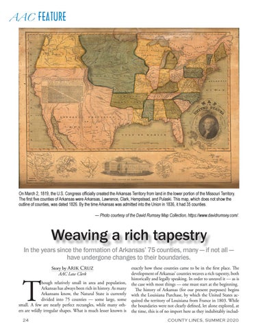
On March 2, 1819, the U.S. Congress officially created the Arkansas Territory from land in the lower portion of the Missouri Territory. The first five counties of Arkansas were Arkansas, Lawrence, Clark, Hempstead, and Pulaski. This map, which does not show the outline of counties, was dated 1826. By the time Arkansas was admitted into the Union in 1836, it had 35 counties. — Photo courtesy of the David Rumsey Map Collection, https://www.davidrumsey.com/.
Weaving a rich tapestry In the years since the formation of Arkansas’ 75 counties, many — if not all — have undergone changes to their boundaries.
T
Story by Arik Cruz AAC Law Clerk
hough relatively small in area and population, Arkansas has always been rich in history. As many Arkansans know, the Natural State is currently divided into 75 counties — some large, some small. A few are nearly perfect rectangles, while many others are wildly irregular shapes. What is much lesser known is 24
exactly how these counties came to be in the first place. The development of Arkansas’ counties weaves a rich tapestry, both historically and legally speaking. In order to unravel it — as is the case with most things — one must start at the beginning. The history of Arkansas (for our present purposes) begins with the Louisiana Purchase, by which the United States acquired the territory of Louisiana from France in 1803. While the boundaries were not clearly defined, let alone explored, at the time, this is of no import here as they indubitably includCOUNTY LINES, SUMMER 2020


