
23 minute read
Weaving a Rich Tapestry


On March 2, 1819, the U.S. Congress officially created the Arkansas Territory from land in the lower portion of the Missouri Territory. The first five counties of Arkansas were Arkansas, Lawrence, Clark, Hempstead, and Pulaski. This map, which does not show the outline of counties, was dated 1826. By the time Arkansas was admitted into the Union in 1836, it had 35 counties.
— Photo courtesy of the David Rumsey Map Collection, https://www.davidrumsey.com/.
In the years since the formation of Arkansas’ 75 counties, many — if not all — have undergone changes to their boundaries.
Story by Arik Cruz AAC Law Clerk
Though relatively small in area and population, Arkansas has always been rich in history. As many Arkansans know, the Natural State is currently divided into 75 counties — some large, some small. A few are nearly perfect rectangles, while many others are wildly irregular shapes. What is much lesser known is exactly how these counties came to be in the first place. The development of Arkansas’ counties weaves a rich tapestry, both historically and legally speaking. In order to unravel it — as is the case with most things — one must start at the beginning. The history of Arkansas (for our present purposes) begins with the Louisiana Purchase, by which the United States acquired the territory of Louisiana from France in 1803. While the boundaries were not clearly defined, let alone explored, at the time, this is of no import here as they indubitably includ-
ed the entirety of present-day Arkansas. (Parry, 57:27-40; Van Zandt, 23-26). Shortly after, in 1804, this territory was divided further into two parts: the Territory of Orleans and the District of Louisiana. The latter of these contained present-day Arkansas and was temporarily under the administrative control of the pre-existing Indiana Territory. This subordination was remedied in 1805 when the District of Louisiana became the Territory of Louisiana (interchangeably referred to as the Louisiana Territory).
The first official use of the name “Arkansas” came in 1806, when a southern portion of land within the Louisiana Territory was designated as the District of Arkansas. A year later, in 1806, the District of Arkansas (at times, also spelled “Arkansaw”) was organized from the southern portion of the Louisiana Territory. In 1812, an act of Congress renamed the Louisiana Territory as the Missouri Territory. A year later, Arkansas County was established by the territorial legislature as a county within the Missouri Territory. In 1815, Arkansas County was divided in order to form Lawrence County.
In late 1818, acts were passed by the legislature of the Missouri Territory to establish three new counties — Clark, Hempstead, and Pulaski, each of which was carved from land in Arkansas County. By 1819, citizens within the District of Arkansas had already been working for a few years to organize an independent territorial government. On March 2, 1819, this desire became reality as an act of the U.S. Congress officially created the Arkansas Territory from land in the lower portion of the Missouri Territory. This new territory included all of present-day Arkansas and a portion of present-day Oklahoma. As one might surmise, this transformation gave rise to what many consider to be the first five counties of Arkansas: Arkansas, Lawrence, Clark, Hempstead, and Pulaski.
With respect to the formation of counties, the laws of Arkansas Territory were largely silent, except where the ascertaining of boundary lines was concerned. Indeed, these laws vested a certain degree of power in “the court of common pleas or the county court of any county now established or hereafter to be established” (i.e., a circuit court, if a county had not yet been established) where the boundary line[s] were not sufficiently ascertained. In such instances, a court order was required to ascertain these boundaries based upon standard land surveying practices. Aside from this provision, the plenary power to establish a county itself resided with the territorial legislature.
The next county to form in the newly established Arkansas Territory was Miller County, organized by an act of the Territorial Legislature in April 1820 and named for James Miller, Arkansas Territory’s first governor. Miller County included most of present-day Miller County, as well as multiple counties in present-day Texas and Oklahoma. Interestingly, Miller County was later abolished in 1838, primarily due to a dispute over its common border with the Republic of Texas, which had only recently seceded from the Republic of Mexico. Given that much of Miller County was effectively lost to Texas around this time, the county was subsequently dissolved, with the remaining territory being attached to Lafayette County. In 1845, Texas was annexed by the United States, which inherently settled the boundary between Texas and Arkansas. However, it would be nearly 30 years before Miller County was re-established in 1874.
Later, in May 1820, Phillips County was created out of Arkansas County and named for Sylvannus Phillips, an early settler and member of the first territorial legislature. In October of 1820, Crawford County was established out of Pulaski County and named for William H. Crawford, then secretary of the treasury, while Independence County was created by dividing Lawrence County along the watershed between the Black and White river valleys.
In the 15 years leading up to Arkansas’ admittance to the Union, another 26 counties were established by the legislature of Arkansas Territory, with one of these being permanently abolished shortly after its creation. This would bring the total number of counties in existence up to 35 at the beginning of 1836. The following is a chronological overview of this establishment process. • Chicot County, established Oct. 15, 1823, from Arkansas County and named for Point Chicot on the Mississippi River. • Conway County, established Oct. 20, 1825, out of Pulaski County and named for Henry Wharton Conway, a territorial delegate to the U.S. House of Representatives • Crittenden County, established Oct. 22, 1825, from Phillips County and named for Robert Crittenden, a governor of the former Arkansas Territory • Izard County, created Oct. 27, 1825, from Independence County. It was named for George Izard, a governor of the former Arkansas Territory and general during the War of 1812. • St. Francis County, established on Oct. 13, 1827, and formed from Phillips County. Named after the St. Francis River, which is a tributary of the Mississippi River. • Lovely County, established Oct. 13, 1827, and formed from the land gained from Lovely’s Purchase, which included a large part of the northwest corner of Arkansas Territory and extended west to the Indian Territory. It was abolished in 1828 after most of its land was ceded to Indian Territory as a result of treaties between the United States and the Cherokee Tribe. The largest part of what remained of the county was included in the creation of Washington County shortly thereafter. • Lafayette County, established Oct. 15, 1827, out of Hempstead County and named for Marquis de
Tapestry
Continued From Page 25 <<<
Lafayette, a French ally of the United States in the Revolutionary War. • Sevier County, created on Oct. 17, 1828, from
Hempstead County and named after Ambrose Sevier, speaker of the Arkansas territorial House of Representatives and one of the state’s first two U.S. senators. • Washington County, established Oct. 17, 1828, out of (now defunct) Lovely County and named for President
George Washington. • Hot Spring County, created on Nov. 2, 1829, from
Clark County. It was named after the naturally occurring hot springs within the county, though the specific spring for which it was named is no longer within the county limits, having been subsumed by Garland
County in 1873. • Jefferson County, established on Nov, 2, 1829, from Arkansas and Pulaski counties and named after President
Thomas Jefferson. • Monroe County, established Nov. 2, 1829, out of Phillips and Arkansas counties and named for President
James Monroe. • Pope County, established Nov. 2, 1829, from Crawford
County and named for John Pope, a governor of the former Arkansas Territory. • Union County, established Nov. 2, 1829, out of Clark and Hempstead counties and named after the petition to form the county, which was given to the legislature in the Spirit of “Union and Unity.” • Jackson County, established Nov. 5, 1829, from Independence County and named for President Andrew Jackson. • Carroll County, created on Nov. 1, 1833, out of Izard
County. Carrol County was named after Charles Carroll (of Carrollton), one of the first to sign the Declaration of Independence. • Mississippi County, established Nov. 1, 1833, from
Crittenden County and named after the Mississippi
River, which forms its eastern boundary. • Pike County, established Nov. 1, 1833, from Clark and
Hempstead counties and named after Zebulon Pike, the explorer and discoverer of Pikes Peak in Colorado. • Greene County, created on Nov. 5, 1833, out of Lawrence County and named for Nathanael Greene, a general in the Revolutionary War. • Scott County, established Nov. 5, 1833, from Crawford and Pope counties. It was named after Andrew Scott, a judge of the Superior Court of Arkansas Territory and a delegate to the state Constitutional Convention of 1836. • Van Buren County, established Nov. 11, 1833, from portions of Conway, Izard, and Independence counties
and named after President Martin Van Buren. • Johnson County, created on Nov. 16, 1833, out of Pope County. Johnson County was named for Benjamin Johnson (1784–1849), a territorial judge. • White County, established Oct. 23, 1835, from Independence, Jackson and Pulaski counties and named after Hugh Lawson White, a U.S. Senator from Tennessee and Whig Party presidential candidate in 1836. • Randolph County, established Oct. 29, 1835, out of Lawrence County. It was named for John Randolph, a U.S. congressman from Virginia. • Saline County, created Nov. 2, 1835, from Independence and Pulaski counties and named after salt works found within its borders and that supplied salt to all of Arkansas and shipped salt to Tennessee, Louisiana, and east Texas. • Marion County, established Nov. 3, 1835, out of Izard County and named for Revolutionary War General Francis Marion.
On June 15, 1836, the Territory of Arkansas entered the union as the 25th state, thus becoming the State of Arkan-
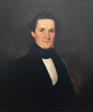
The first elected Governor of Arkansas was James Conway. The city of Conway, but not the county of Conway, is named after him.
— Photo from the Old State House website.
sas. James Conway (after whom the city of Conway, but not the county of Conway, is named) was subsequently elected to be the state’s first governor. In the months leading up to statehood, Arkansas’ constitutional convention had drafted a document to qualify Arkansas for admission to the Union. This would become Arkansas’ first constitution. Unsurprisingly, this first constitution was brief (only four pages, front and back), flexible, general in language, and relatively lenient in terms of power. Much like the laws of Arkansas Territory had been, Arkansas’ first constitution was effectively silent on the issue of county establishment, except that no county then established “could be reduced by the establishment of any new county to less than 900 square miles,” nor be reduced to a lesser population than its ratio of representation in the House of Representatives, nor could any county be established that contained less than 900 square miles (with the exception of Washington County, which could be reduced to 600 square miles) or a less population than would entitle a county to a member in the House of Representatives.
Before Arkansas’ secession from the United States and subsequent admission to the Confederate States of America, another 22 counties were established by the Arkansas Legislature. Thus, by the beginning of the Civil War in 1861, Arkansas was divided into 56 counties (since Miller County had not yet been re-established). The following counties were created between 1836 and 1859. • Benton County, established on Sept. 30, 1836, from Washington County and named after Thomas Benton, a U.S. senator from Missouri. • Madison County, created on Sept. 30, 1836, from Washington County and named after President James Madison. • Franklin County, established Dec. 19, 1837 out of Crawford and Johnson counties and named for Benjamin Franklin. • Poinsett County, created Feb. 28, 1838, out of Greene and St. Francis counties and named for Joel Roberts Poinsett, a U.S. secretary of war (and namesake of the poinsettia). • Desha County, established Dec. 12, 1838, from Arkansas and Chicot counties, and named for Captain Benjamin Desha, a hero in the War of 1812. • Searcy County, created Dec. 13, 1838, out of Marion County and named for Richard Searcy, a prominent civil servant, major landowner, and circuit court judge. • Yell County, established Dec. 5, 1840, from Pope and Scott counties and named for Archibald Yell, the second governor of Arkansas. • Bradley County, created on Dec. 18, 1840, out of Union County and named for Hugh Bradley, a soldier in the War of 1812 and a prominent area settler. • Perry County, established Dec. 18, 1840, from Conway County and named after Commodore Oliver Perry, a
naval officer in the War of 1812. • Ouachita County, created in Nov. 29, 1842, out of Union County and named after the Ouachita River. • Montgomery County, established Dec. 9, 1842, from Hot Spring County and named after Richard Montgomery, a general during the Revolutionary War. • Newton County, created on Dec. 14, 1842, out of Carroll County and named for Thomas Newton, a state senator, member of the U.S. House of Representatives, and U.S. Marshal. • Fulton County, established Dec. 21, 1842, from Izard County and named for William S. Fulton, the last governor of the Arkansas Territory. • Polk County, created on Nov. 30, 1844, out of Sevier County and named for President James Polk. • Dallas County, established Jan. 1, 1845, from Clark and Bradley counties and named after George Dallas, the 11th vice president of the United States. • Prairie County, created Oct. 25, 1846, out of Monroe and Pulaski counties and named after the area’s dominant characteristic, the Grand Prairie of eastern Arkansas. • Drew County, established Nov.26, 1846, from Arkansas and Bradley counties and named for Thomas Stevenson Drew, the third governor of Arkansas. • Ashley County, created Nov. 30, 1848, out of Chicot, Drew, and Union counties and named after Chester Ashley, a U.S. senator and otherwise prominent Arkansan. • Calhoun County, established Dec. 6, 1850, from Dallas and Ouachita counties and named for John C. Calhoun, the seventh vice president of the United States. • Sebastian County, created on Jan. 6, 1851, out of Crawford, Polk, Van Buren, and Scott counties. It was named for William K. Sebastian, a judge, state senator and U.S. senator from Arkansas. • Columbia County, established Dec. 17, 1852, from Lafayette, Hempstead, and Ouachita counties and named after the fictitious Columbia, a female personification of the United States. • Craighead County, created Feb. 19, 1859, out of Greene, Mississippi, and Poinsett counties and named after Thomas H. Craighead, who represented Mississippi and Crittenden counties in the state legislature.
Only two Arkansas counties have the unique distinction of having been established during the Civil War, each of which was created in 1862. Cross County was created on Nov. 15, 1862, out of St. Francis, Poinsett, and Crittenden counties and named for Col. David C. Cross, a Confederate soldier and prominent politician. Shortly thereafter, on Nov. 26,
Tapestry
1862, Woodruff County was established from parts of Arkansas and Lawrence counties. It was named in honor of William Woodruff, editor and publisher of the Arkansas Gazette, the first newspaper in Arkansas. While each of these counties was created under the auspices of a new constitution (something that was necessary as the state left the Union), there were very few substantive changes made to that constitution aside from replacing references to the United States of America with references to the Confederate States of America. As such, county formation remained implicitly in the hands of the legislature.
By 1864, Arkansas’ third constitution was written under the terms of the U.S. government’s plan for wartime reconstruction, intended to hasten the reestablishment of loyal state governments in the Southern United States. Ratified on March 14, 1864, this new constitution provided for a Unionist state government, in spite of the fact that a Confederate one — though significantly weakened — continued to exist. While a couple of drastic changes were included in the 1864 constitution — abolishment of slavery and repudiation of secession, for example — it did not change the approach taken with respect to the establishment of counties, except that minimum county size was reduced from not less than 900 square miles in the original constitution to not less than 600 square miles. The population size requirement tied to representation in the House remained unchanged. Only one county was formed by the General Assembly under this constitution. Indeed, Little River County was established on March 5, 1867, out of Sevier and Hempstead counties and named for the Little River, a tributary of the Red River, which serves as the county’s northern and eastern boundaries.
A mere four years after the adoption of its third constitution, Arkansas re-entered the Union and a fourth constitution was ratified on March 13, 1868, in order to begin the Reconstruction Era under the terms of the Reconstruction Acts of 1867. This constitution made racial discrimination illegal, provided support for both lower and higher public education, and fixed legislative apportionments to favor counties with large African-American populations. Moreover, the 1868 constitution also significantly enhanced the power of the state government and broadened the powers of the governor. Nonetheless, still no express provisions were written with respect to the establishment of counties, aside from the now commonplace requirement that no county then established should ever be reduced by the establishment of any new county to less than 600 square miles, nor could any county established thereafter contain less than 600 square miles. The population requirement contained in each previous constitution, however, was conspicuously absent. All but two of Arkansas’ final 17 counties were formed under this constitution. By the end of 1873, Arkansas was divided into 73 counties. • Sharp County, established July 18, 1868, out of Lawrence County and named after Ephraim Sharp, an early settler and state legislator from Lawrence County. • Grant County, created on Feb. 4, 1869, from portions of Jefferson, Hot Spring, and Saline counties and named for General (later President) Ulysses S. Grant. • Boone County, established April 9, 1869, out of Carroll and Marion counties and named for frontiersman Daniel Boone. • Nevada County, created March 20, 1871, from Columbia, Hempstead, and Ouachita counties and named after the state of Nevada, which has a similar outline to the county’s boundaries. • Logan County, established March 22, 1871, out of Franklin, Johnson, Scott, and Yell counties. Logan County was originally named Sarber County, after the state senator who proposed the county’s creation to the legislature. However, the legislature later changed the name to Logan County in honor of James Logan, an early settler in the area on Dec. 14, 1875. • Lincoln County, created March 28, 1871, from Arkansas, Bradley, Desha, Drew, and Jefferson counties and named after President Abraham Lincoln. • Baxter County, established March 24, 1873, out of Fulton, Izard, Marion, and Searcy counties and named for (and by) Elisha Baxter, then governor of Arkansas. Notably, Baxter County was created as a result of Governor Baxter himself introducing legislation to the General Assembly on a day on which most of the legislature was not present, thus those representing the counties that ultimately lost land to Baxter County could not vote against the bill. • Clay County, created March 24, 1873, from Randolph and Greene counties. It was originally named Clayton County after John Clayton, a state senator, but was changed in 1875 to Clay County in honor of Secretary of State Henry Clay due to a resentment held by citizens in the area against John Clayton’s brother, Powell, who had been the first Reconstructionist governor of Arkansas. • Garland County, established April 5, 1873, out of portions of Hot Spring, Montgomery, Saline, and Clark counties and named for Augustus Hill Garland who served as governor in 1874, U.S. senator from 1876 to 1885, and U.S. attorney general in 1885. • Faulkner County, created on April 12, 1873, from Conway and Pulaski counties and named for Colonel Sanford C. Faulkner a Confederate soldier and the composer of the song “The Arkansas Traveler.”
Continued From Page 27 <<<
• Lonoke County, established April 16, 1873, out of Prairie and Pulaski counties and named by a railroad surveyor who used a massive red oak tree as a landmark. • Cleveland County, created April 17, 1873, from Bradley, Dallas, Jefferson, and Lincoln counties. It was originally named Dorsey County after U.S. Senator Stephen Dorsey, but the name was changed to honor President Grover Cleveland in 1885. • Howard County, established April 17, 1873, out of Hempstead, Pike, Polk, and Sevier counties and named after James H. Howard, a state senator. • Lee County, created on April 17, 1873, from Crittenden, Monroe, Phillips, St. Francis and named for Confederate General Robert E. Lee. • Stone County, established April 21, 1873, out of parts of Izard, Independence, Searcy, and Van Buren counties and named for the rugged, rocky terrain of the area.
Near the end of Reconstruction, on Oct. 13, 1874, a fifth and final (i.e., current) constitution was adopted. This iteration of the constitution was written with the goal of more adequately protecting the people of the state from the government itself by significantly limiting its powers. Indeed, many Arkansans were distrustful of the government after having been forced through a litany of changes to the political paradigm over its relatively short history as a state. Thus, the 1874 constitution reflected a general suspicion of government and authority and incorporated more changes than any of the previous constitutions ever had. As we see remnants of that today, county governments became extremely powerful, functioning as quasi-independent administrative units of the state with jurisdiction over roads and bridges, the local judiciary, and taxation, as well as spending. Additionally, the number of constitutionally mandated county offices grew fivefold (from two to 10), and the powers of the governor were greatly reduced at the time. As a general concept, it is more than fair to say that a great deal of authority was transferred from state to local government.
With respect to county formation, the 1874 constitution provided quite a bit more guidance than previous iterations
had. Accordingly, no county then established could be reduced to an area of less than 600 square miles, nor to less than 5,000 inhabitants, nor could any new county be established with an area of less than 600 square miles and population of less than 5,000 inhabitants (though this provision did not apply to Lafayette, Pope, and Johnson counties). In addition, this constitution provided that no part of a county could be taken off to form a new county, or a part thereof, without the consent of a majority of the voters living in the part proposed to be taken off. Subsequent legal decisions have clarified, however, that such majority consent is not required for the General Assembly merely to move or change already extant boundary lines. The 1874 constitution also required that county seats be established or changed only with the consent of a majority of the qualified voters of the county to be affected, though newly formed counties were allowed to temporarily locate the county seat during the formation process. These provisions remain unchanged to this day, as may be seen upon reading Article XIII of the Arkansas Constitution. Arkansas’ final two counties, including the The 1874 constitution reflected a general suspicion of government and authority and incorporated more changes re-establishment of Miller County, were created under this final iteration than any of the previous constitutions ever had. As we see rem- of the state’s constitution. Indeed, nants of that today, county governments became extremely pow- Miller County was erful, functioning as quasi-independent administrative units of recreated by the Arkansas General Asthe state with jurisdiction over roads and bridges, the local judisembly from a portion of Lafayette ciary, and taxation, as well as spending. County on Dec. 22, 1874, and Cleburne County was established on Feb. 20, 1883, from Independence, Van Buren, and White counties and was named after General Patrick Cleburne, who served in the Confederate army. In the years since the formation of Arkansas’ 75 counties, many — if not all — have undergone changes to their boundaries. Given the relatively low amount of guidance on county formation and alteration given by the Arkansas Constitution, it should come as no surprise that the legislature has passed additional guidance on this topic. Arkansas Code Annotated § 14-14-101 et seq. provides the law in this area. Much of the first section of this subchapter is merely a codification of Article XIII of the state constitution. It also makes clear that “the See “TAPESTRY” on Page 30 >>>
Tapestry
power to change county boundaries is inherent in the General Assembly, subject to express constitutional restrictions.” The remainder of the subchapter goes on to provide that changes to county boundaries may be initiated by the General Assembly or by a petition to the legislature by persons whose rights and interests would be affected by the boundary change. (A.C.A. § 14-14-102). To be taken under consideration by the legislature, such a petition is required to be signed by not less than 15 percent of the voters residing in the area(s) to be affected by the proposed boundary change. A petition to form an entirely new county must be preceded by an election on the issue and consent by the majority of the voters in the part proposed to be taken off. (A.C.A. § 14-14-103). Petitions must be accompanied by the following documentation: A survey of the proposed boundary alterations (except where common boundaries are being dissolved) performed by a professional surveyor, and a map drawn to scale of the area to be affected by the petition. These provisions allow the General Assembly and the citizens that it serves to work in tandem to ensure that counties are able to properly provide services in as efficient a manner as possible. In the years going forward, it is a relative certainty that Arkansans, whether directly or through their political representatives, will utilize the provisions of the Arkansas Constitution and the Arkansas Code to weave further detail into the tapestry that depicts the history of Arkansas’ many great counties.
Sources:
Ark. Code Ann. §§ 14-14-201 through 206 (2020).
Ark. Const. Art. 13, §§ 1-4.
Ark. Const. Art. 7, § 28.
Arkansas Constitutions Collection, The Arkansas Digital Ark-ives, Arkansas State Archives, http://ahc.digital-ar.org/cdm/ landingpage/collection/p16790coll1 (last visited June 1, 2020).
Arkansas History Timeline: 1800s, Arkansas Secretary of State, https://www.sos.arkansas.gov/education/arkansas-history/arkansas-history-timeline/1800s (last visited June 1, 2020).
Arkansas Maps, Pine Bluff — Jefferson County Library System, https://www.pineblufflibrary.org/reference-research/ digital-collections/map-collection/arkansas-maps (last visited June 1, 2020).
Atlas of Historical County Boundaries — Arkansas, Atlas of Historical County Boundaries Project, The Newberry Library Center for American History and Culturehttps:// publications.newberry.org/ahcbp/pages/Arkansas.html (last visited June 1, 2020).
Berry, Trey J., Hunter-Dunbar Expedition, Encyclopedia of Arkansas, Central Arkansas Library System, https://encyclopediaofarkansas.net/entries/hunter-dunbar-expedition-2205/ (last visited June 1, 2020).
Bolton, S. Charles, Louisiana Purchase through Early Statehood — 1803 through 1860, Encyclopedia of Arkansas, Central Arkansas Library System, https://encyclopediaofarkansas. net/entries/louisiana-purchase-through-early-statehood1803-through-1860-398/ (last visited June 1, 2020).
Capace, Nancy, The Encyclopedia of Arkansas (1998).
Connor, Seymour V., Miller County, Arkansas, The Handbook of Texas Online — Texas State Historical Association (TSHA), https://tshaonline.org/handbook/online/articles/ hcm91 (last visited June 1, 2020).
Entries — Entry Category: Counties, Encyclopedia of Arkansas, Central Arkansas Library System, https://encyclopediaofarkansas.net/entry-category/counties/?post_type=eoaentry (last visited June 1, 2020).
Goss, Kay C., Arkansas Constitutions, Encyclopedia of Arkansas, Central Arkansas Library System, https://encyclopediaofarkansas.net/entries/arkansas-constitutions-2246/ (last visited June 2, 2020).
J. Steele, Compiler; M’Campbell, J., Compiler. Laws of the Arkansas Territory (1835).
Kilpatrick, Judith and Samantha Fields, Law, Encyclopedia of Arkansas, Central Arkansas Library System, https://encyclopediaofarkansas.net/entries/law-2901/ (last visited June 1, 2020).
Pulaski County v. County Judge of Saline County, 37 Ark. 339 (1881).
Reynolds v. Holland, 35 Ark. 56, 59 (1879).
Territorial Arkansas Collection, The Arkansas Digital Arkives, Arkansas State Archives, http://ahc.digital-ar.org/cdm/ landingpage/collection/p16790coll6 (last visited June 1, 2020).
Williams, Patrick G., Politics and Government, Encyclopedia of Arkansas, Central Arkansas Library System, https:// encyclopediaofarkansas.net/entries/politics-and-government-394/ (last visited June 1, 2020).
Continued From Page 29 <<<


