Email 206ashby@gmail.com
Cell
703-598-9529
Major Skills Landscape Design Project Management Children’s Learning Environments
LID Stormwater Management Community Engagement & Outreach Research & Strategy

Public Speaking, Presentations, Client & Design Team Communications Team Builder
LANDSCAPE DESIGN & URBAN PLANNING PORTFOLIO
LINDA ASHBY
ASLA, LEED ® BD+C
Seattle Public Utilities


Seattle, WA
Shape Our Water Vision Plan


A $1.6 million project at MAKERS to develop a stakeholder driven plan with racial and social justice work and climate change preparedness at its core. The plan helps guide 50-years of Seattle’s equitable and environmentally sound, multi-benefit green drainage and wastewater infrastructure investments. We designed & facilitated a comprehensive, innovative and fully remote engagement and outreach campaign.

Role on Project
Deputy Project Manager (under the Partner-in-Charge) Project Coordinator
Skills
Complex client and project team coordination
Community engagement
Co-creator partner contracting & oversight
Project budget support
Qualitative & content outcomes analysis
Documentation & production
Complex project scheduling
Remote meeting platforms (numerous)
Adobe (InDesign, Photoshop, Illustrator)
An engagement and outreach strategy with user-friendly, fun and informative opportunities to reach key stakeholders, resulting in a community vision with long-range project goals and priorities.
Prioritize the most impacted communities whose voices historically have not been heard
GET TO KNOW
SEATTLE PUBLIC UTILITIES DRAINAGE AND WASTEWATER


Booklet that simplifies technical information and supports informed engagement
Social justice mapping study

MS Office Suite
City of Portland

Portland, OR
Citywide Space Use Master Plan
Phase One - MAKERS led the multi-phase process to develop a master plan that would establish a citywide strategy for space planning, capital investment, leasing decisions, and property acquisition and divestment. We worked with the client to understand major strategic issues and citywide facilities needs through an engagement strategy that combined interviews, facility tours, and workshops with over 100 participants from 32 city bureaus and of
KEY CHALLENGES
Strategic issues identifed in Phase 1 that are not identifed under Stand-Alone issues relate to one of two Key Challenge categories. These issues are summarized below and described in detail in “Key Challenges Analysis” on page 21.
EAST SIDE KEY CHALLENGE ISSUES SUMMARY
• City facilities are concentrated downtown and on the west side; east side communities most in need of services face barriers to accessing facilities.
• Downtown may not be the best or most costeffective location for some employees or functions, such as inspectors.
• Many bureaus have occasional or regular need for east side work and/or meeting spaces.
OPERATIONS & EMERGENCY RESPONSE KEY CHALLENGE ISSUES SUMMARY
• PPB facilities and PBOT, CityFleet, PPR maintenance, and PFR operations campuses are aging and poorly confgured. These operations facilities, and spaces supporting PBEM and other emergency response operations, are not wellpositioned to serve future demand and provide emergency response. Some sites are critically defcient with growing liabilities and risks.
• The quality, performance, and amenities of facilities used by general fund operations staff are poor relative to those used by offce-based staff.
• The Jerome Sears Campus was given to the City for use by emergency response functions but is in need of signifcant investment and is currently underutilized.
Downtown
LEGEND CUSTOMER-FACING FACILITIES
PLANNING CONSIDERATIONS
This key challenge analysis is informed by trends and best practices, and BLT feedback received during interviews and the Visioning Workshop.

CO -LOCATION BENEFITS
As facilities are expensive to build and maintain, City facility investments should aim to address as many issues as is feasible. Co-location of multiple functions in an east side facility is preferred by some bureaus to support collaboration and avoid isolation.
RELEVANT VISIONING WORKSHOP OUTCOMES
The BLT identifed many City functions related to customer service, education, enforcement, construction, and civic engagement that might better serve Portland residents and support City operations if located outside of downtown, including:
• General City information/311
• Construction team meetings, pre-bid conferences
• Community outreach, “roaming” Council meetings
• Workspace for feld-based staff, staff doing business away from their permanent location, COOP use, or project-specifc needs
CUSTOMER SERVICE DELIVERY TRENDS & BEST PRACTICES
CUSTOMER SERVICE DELIVERY MODELS
One Counter to Rule Them All One service counter representing all City services that can answer questions, route complaints, provide way-fnding assistance or even a one-stop-shop experience, potentially integrated with complimentary online tools.
Community Service Centers
Frequently-used services and neighborhood-based programming located in non-central communities, especially those historically underserved.
Targeted Services Co-locate and partner with community liaisons and other agencies such as Multnomah County and Tri-Met to deliver complementary services most needed by a particular community, e.g., assistance to lower-income residents.

Meet Out in the Community
Multi-Modal Service Delivery
Bureau representatives host community meetings and events, booths at festivals, and targeted programs at community centers.
FIGURE 2. CUSTOMER-FACING FACILITIES (EXCLUDING POLICE FACILITIES)


Of the 21 public-facing City customer service and public meeting facilities, 14 are located downtown. Only one facility is in east Portland.
• Simple (i.e., residential and small business) permit intake and project assistance
• Bill pay
• Class/event/service registration
• Education, training, recruitment
• Neighborhood-based programming
• Partnerships with other providers such as county agencies or non-profts
• Support for local arts, culture, entrepreneurship, etc.
They identifed the following features as important to equitable customer service delivery:
• Locations near public transit and in mixed-use environments
• Support for non-native English speakers
• Flexible service hours
• Targeted or grouped programming and resources
• In-person and technology-based services
The Gateway neighborhood and along the I-205 corridor was identifed as the most promising area for locating new east side services or facilities.
Flexible Meeting Spaces
Provide services in multiple locations and/or formats to increase accessibility; use web and live chat technology solutions for information requests, bill pay, and applications; and pop-up events.
RELEVANT FACILITY TYPES
Welcoming multi-use space with seating and meeting options for City and community use. Programming can include community job fairs and recruitment events; education and training for residents, businesses, community groups, and City employees; or internal meetings. Can be co-located in mixed-use building with support businesses (e.g., cafe or daycare).
Fly-in Workstations Unassigned workstations co-located with staff support amenities (e.g., storage, meeting space, breakrooms, feet parking).
Project Space Flexible and reconfgurable offce space designed to support limited-duration, project-specifc needs; can be rented or used as fy-in or COOP space when not in use as project space.
Project Urban
Project Coordinator Researcher Writer Skills Needs assessment Alternatives Engagement Interviews Photography InDesign Illustrator MS Office 360
Role on
Planner
FEBRUARY 2020 DRAFT nEE d S aSSESS m E nt Summary DRAFT FEBRUARY 2020 DRAFT 23 K E y c hall E n GES a naly S S DRAFT
3. CUSTOMER SERVICE DELIVERY TRENDS & BEST PRACTICES POTENTIAL EAST SIDE FACILITY USE BY BUREAU ATTORNEY AUDITOR BDS BES BHR BPS CAO 311 CAO FAC CIVIC COUNCIL OEHR PBEM PBOT PFR PHB PPB PPR PWB ASSIGNED WORKSPACE FLY-IN WORKSTATION MEETING ROOMS Meeting (2-12 people) Board (~24 people) Large (~75 people) X-Large (~200 people) CUSTOMER SERVICE CITY OF PORTLAND LONG-RANGE FACILITIES MASTER PLAN 24 K y chall GES nalyS S SOLID FILL FREQUENT USE Daily or weekly OUTLINE OCCASIONAL USE Bi-weekly or less To develop east side facility alternatives, bureaus were asked to consider east side key challenge planning considerations, customer service trends, and best practices; then identify which of the following four types of east side space types they might use, and with what frequency (Figure 4): Assigned workspace: typical offce spaces, including workstations, breakrooms, storage, and feet parking. Fly-in workstation: unassigned, temporary places to work with or without storage options. Meeting rooms: spaces of various sizes and confgurations for internal and public-facing meetings. Customer service: public-facing spaces, service counters, and other facility types. Figure 5 on pages 24 and 26 details the bureau-specifc needs that could be supported by the above facility types. FiG RE POTENTIAL EAST SIDE FACILITY USE BY BUREAU SUMMARY MATRIX EAST SIDE KEY CHALLENGE NEEDS ASSESSMENT: POTENTIAL FACILITY TYPES AND USERS DRAFT
FIGURE
Urban Design Master Plans


Port of Kennewick Waterfront MP

Kennewick, WA
This MAKERS master plan integrates the Port’s Clover Island and surrounding area into a cohesive historic waterfront district. The plan prioritizes district economic investments over the next 15-20 years, thoughtfully connects the new district with downtown Kennewick, and creates a thriving environment for residents and visitors.

Pacific Hospital Campus Development Study


Seattle, WA
A study at MAKERS to provide a strategic framework that guides future preservation and development decisions for the southern portion of the Paci


Design & Planning Associate Team support Skills Engagement Research Writing Document design Editing & QA/QC InDesign Photoshop MS Office 360 MASTER PLAN JUNE 22, 2021 PORT OF KENNEWICK 17 WATERFRONT DISTRICT MASTER PLAN - APPROVED AND ADOPTED BY RESOLUTION 2021-12 This section outlines recommended actions that will help achieve the community's vision for the historic waterfront district and attract complementary investments from district property owners, business owners, tenants, and developers. frst presents checklist designed to assist the Port staff and commission in using the master plan to guide district development. It then summarizes the vision for each district node across the following three categories: An Active District Recreation A Place to Call Home Site plans and sketches in each section summarize and illustrate recommendations to achieve the vision. Together, these recommendations will create a unifed and attractive district that is an enjoyable destination for visitors, safe and comfortable place for residents, and supports economic recovery, growth, and vitality. Please note, though specifc private development types are described and illustrated, economic conditions and partnership opportunities are evolving and difcult to predict with certainty. Recommendations described in this section are intended to clarify the vision for each node but provide the Port fexibility to evolve with market conditions and respond to opportunities that arise. Figure 22. District nodes A B C D F COLUMBIADRIVEWEST: THE WILLOWS COLUMBIA DRIVE CENTRAL: COLUMBIA GARDENS E COLUMBIA DRIVE EAST: CABLE GREENS CLOVER ISLAND WEST CLOVERISLAND CENTRAL CLOVER ISLAND EAST In addition to the node-specifc recommendations that follow, the Port should implement the district-wide actions listed below. Use design guidelines to create cohesive district identity (see "Design Guidelines" on page 41). Support the City's efforts to improve the pedestrian and bicycle experience on Washington Street and Columbia Drive. Work with the City to enhance connections to historic downtown Kennewick. Evaluate acquiring additional land as opportunities arise. Increase the ability for the community to connect with water on site. Improve and protect ecology and function as a key district amenity. Retain ownership of Clover Island as a distinct environment and special community asset. Complete Clover Island shoreline enhancements in partnership with the USACE. Pursue private development that contributes to achieving the community's vision and generates revenue to support amenities, economic recovery activities, and year-round event programming. 41 WATERFRONT DISTRICT MASTER PLAN APPROVED AND ADOPTED BY RESOLUTION 2021-12 The historic waterfront district has two unique areas — Clover Island and the area along Columbia Drive. While Clover Island is heavily tied to the Columbia River, Columbia Drive is connected to the area's industrial past and historic downtown. Design guidelines will help unify new and existing development by creating a singular and coordinated identity. Design guidelines defne an area's look and feel to create unique identity. The following guidelines are intended to celebrate the waterfront district's history, connection to water, and pedestrian focus. Rooted in the guidance established in the 2005 Clover Island Master Plan and the 2011 Willows Wine Village Pattern Language document, these updated guidelines refect building styles that now extend to Port-owned parcels along Columbia Drive. Maintain high quality craftsmanship using context sensitive building styles, design elements, and materials. Integrate local cultural and historical themes and artwork into building and site design where appropriate. Celebrate and enhance connections to the Columbia River and Duffy’s Pond. Emphasize pedestrian-oriented buildings and site planning. Provide a year-round enjoyable pedestrian experience by incorporating design elements that respond to the region’s specifc environmental conditions. This includes protection from wind and snow in winter and access to shade, views of the water, and areas of respite in the summer. Accommodate all modes of transportation, including bicycles and transit, where available. Figure 64. The Food Truck Plaza provides space for people to enjoy the scenic interior waterfront (Source: Kim Fetrow Photography) PACIFIC HOSPITAL Campus Development Study November 3, 2021 Pacific Hospital Campus Development Study 13 Figure Campus open spaces and views Pacific Hospital Campus Development Study 17 SIGNAGE AND WAYFINDING Signs symbols, and codes are commonly used to help visitors understand and navigate a site. Ideally these tools are distributed throughout the site, identifiable from a distance, and easily understood despite language barriers. These tools also offer the opportunity to raise awareness of site history, natural features, or other contexts The existing signage on the PHPDA campus does not support the full range of needs and uses. Entrance signs skew toward vehicles and do not sufficiently consider how and where people may arrive via other transportation modes. Campus signage focuses on medical clinic uses and does no adequately highlight the range of other services or organizations Most exterior signage is limited to English which does not support or reflect the diverse community that uses and relies on campus services. Wayfinding through the campus can be challenging, particularly within the medical clinic spaces and in the interior of the Tower. These challenges are likely to increase as new esidents and visitors are added to the North Lot Finally, existing signage is focused primarily on directional information and does no include interpretive elements that reflect the unique history or invite exploration of the campus. Wayfinding signage is scaled and ocated to support vehicular circulation and access points. Existing campus signage does not reflect the full range of current uses of the campus.
Role on Projects
East Sumner Neighborhood Plan Update


Sumner, WA
The plan update framed a mixed-use urban village that will protect and enhance a wetland, create a central neighborhood natural park amenity, maintain local and regional commercial development, and increase opportunities for multifamily housing.


Fircrest School
Land Use Assessment
Shoreline, WA
MAKERS lead a collaborative team on this report for Washington State Office of Financial Management that identifies sites for additional health facilities and maximizes the longterm revenue generating opportunities and infrastructure needs for the campus property.


Roles on
Update
Implementation + Phasing


Rezone two parcels on 162nd Avenue East north of 164th Avenue Court East to Medium Density Residential, to create a buffer between existing High Density and Low Density Residential.

Maintain existing residential densities in remaining areas in the neighborhood.

• Density increases are not recommended at this time. By simply allowing stand-alone apartments in MDR and HDR, and adding those zones in key areas, it is anticipated that residential development will become more feasible. This will likely result in overall residential densities similar to or reduced from the 2015 Plan.
Within the ESNP area, limit the height of multifamily residential to three- to fourstory along 60th Street East, 160th Avenue
East, and around the Central Park, in order to maintain a pedestrian-friendly, neighborhood scale.
Maintain the General Commercial properties south of 64th Street East as General Commercial and prohibit residential development there to reserve the area for commercial development.
Maintain pedestrian-oriented Neighborhood Commercial zoning in the 160th Avenue East and 60th/Main Street East area to

Table 1 Summary chart comparing the three comprehensive alternatives CHARACTERISTIC ALTERNATIVE 1. 2 Story Nursing on Madrona (Area 3) 2. 1 or 2 story Nursing on NE Corner (Area 1) 3. 1 Story Nursing on Madrona (Area 3) million - $58.9 million $42.2 million - $49.7 million The NE Corner (Area 1) is flat and near the kitchen story nursing facility provides expansion space The site provides open space The NE corner is not the DSHS preferred nursing facility additional cost for stormwater pipe relocation + DSHS preferred location and configuration + DSHS prefers BHC in NE corner + DSHS prefers one-story nursing facility - Very little expansion space - Site separated from campus - Site is separated from many other Fircrest School buildings and facilities evelopment provides $50.8 58.9 million to CEP&RI Trust - Development provides $35.8 million- $41.2 million to CEP&RI Trust. on Madrona site Commercial development Retains Madrona site trees + A park or park + soundstage on the SW corner + Commercial development on the SE corner (Area 7) - Loss of Madrona site trees Avoids residential next to lab Park on Madrona benefits new residential development and saves an important stand of There is no revenue for Dan Thompson Account + Avoids residential next to PHL + Yields approx. $6.4 million$8.5 million for Dan Thompson Account - Park at SW rather than SE corner reduces income to the State overall
Urban Planning & Marketing
Writing & editing QA/QC
SUMNER NEIGHBORHOOD PLAN
East Sumner Neighborhood Plan Update Planning Commission Recommendation
EAST
UPDATE 2020 Plan
To encourage the growth needed to support the local economy, the City may update Comprehensive Plan designations and zoning classifications for many portions of the East Sumner neighborhood. Zoning and regulations should allow more flexibility to respond to market demands for various residential types and commercial uses. The 2020 ESNP recommends future development that creates an economically vital walkable urban village with enhanced natural community amenities. This section discusses the steps needed to implement and phase-in the community’s plan. Commercial/Residential Development • Allow multifamily or mixed-use development of up to 40 dwelling units per acre in the High Density Residential and General Commercial zones, to increase development feasibility of environmentallyconstrained sites.
regulations for the ESNP area to allow multifamily residential south of 62nd Street East and north of 64th Street East (instead of current prohibition).
Rezone several properties along 60th Street East up to the wetlands boundary for highdensity residential to allow ground floor/ stand-alone apartments as a permitted principal use (at 40 dwelling units per net acre, the same as General Commercial zone).
page 18 East Sumner Neighborhood Plan
YMCA Pomona Villa Mercadito del Valle Sumner Senior Center Sumner Veterinary Hospital Windmill Gardens Central Wetlands Preserve Sumner Community Food Bank Rainier View Park SalmonCreek GasCorridor Main Street East 410Hwy 64th Street East 62nd Street East 160th Avenue East 158th Avenue East Parker Road East 162nd Avenue East SumnerTappsHwyE 60th Street East 164thAveCtEast possible, work with the YMCA to orient their future activities toward path and the potential park to create safe, comfortable connection and lively park at the Central Wetlands Preserve’s major entrance. A new park or, at minimum, entrance to trails around the Central Wetlands Preserve becomes focal point for East Sumner. A cooperative, area-wide approach to wetland mitigation higher quality wetlands and improves development feasibility. A mix of cottage/single family homes, townhomes, and small apartment buildings with shared open space and pedestrian connections increase housing options and livability. Regional commercial development makes use of freeway access and visibility. Trees and landscaping detain and treat rainwater runoff and enhance pedestrian connections in parking lots. Commercial ground floors invite pedestrians, and residents living above support commercial activity. A range of mid- to high density “stand-alone” residences provide a diversity of homes and support commercial development. A network of mid-block connections and sidewalks offer safe and comfortable paths for people to walk, bike, or roll to destinations. Pedestrian-oriented streets and special corners have ample sidewalks, street trees, “pocket parks”/plazas as feasible, and well-designed building entrances facing the street to create vibrant neighborhood core. 500 1,000 250 Feet minute walk to Fred Meyer Visualization of the East Sumner Village around year 2040 Prepared by MAKERS architecture and urban design LLP with BSM Engineering Community Attributes JLA Public Involvement Toole Design Group URBAN PLANNING & ASSOCIATED CONSULTING SERVICES PORT OF ASTORIA WATERFRONT MASTER PLAN Image Credit: Dave Hoefler, “Possibilities” Astoria, OR, USA For Jackson County Roads and Parks Prepared by: MAKERS architecture and urban design MxM Landscape Architecture Johnson Economics October 27, 2021 BEAR CREEK GREENWAY REVISIONING PLAN Photo: Robert Ashworth Marketing proposals A report for the Washington Office of Financial Management | Fircrest School Land Use Assessment 12 Future Needs
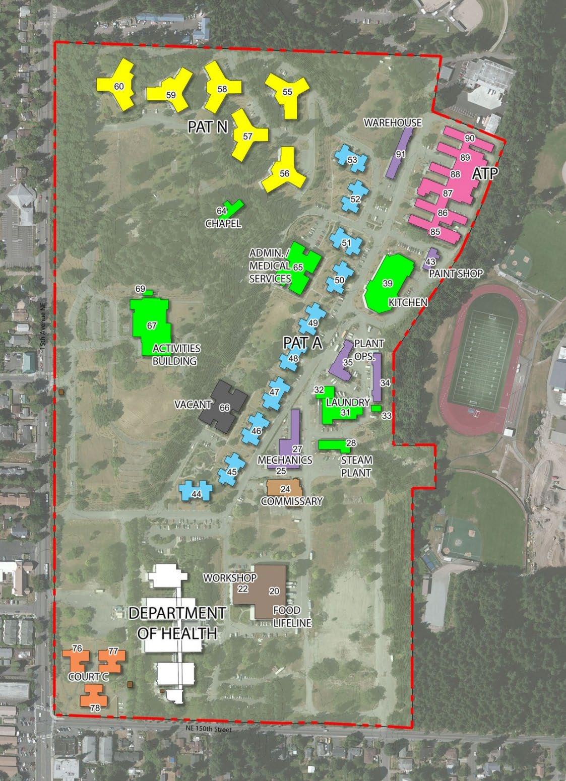
Opportunities The Fircrest Residential Habilitation Center (RHC) has two residential programs; a nursing facility that provides individualized healthcare and activities to persons who have unique medical needs (Pat N in Figure 4), and an intermediate care facility for individuals with intellectual disabilities (ICF/ID) that provides individualized habilitative services. (Pat A in Figure 4.) Figure 4 Map of existing buildings on the campus Map of existing buildings from the Fircrest School Campus Master Plan Phase III (Phase III Master Plan) Fircrest School Land Use Assessment A Report for the Washington State Office of Financial Management January 15, 2021 Prepared By MAKERS architecture and urban design Heartland Schemata Workshop Perteet Transpo The Watershed Company
Update Planning Commission Recommendation
and
Three Tree Montessori
School
Burien, WA Redwood Meadow Children’s Discovery Garden
“The environment must be rich in motives which lend interest to activity and invite [one] to conduct [their] own experiences,” wrote Maria Montessori. This richly sensorial outdoor learning experience, scaled for children ages 2-13, provides juxtaposed color palettes, textures, height variations, and progressive age-appropriate challenges and levels of participation. Durable natural materials support young stewardship and provide discovery of sights, sounds, smells, tastes, and touch.
Role on Project
Landscape Designer


Grounds Committee Lead Skills
Concept to details

Layout plan
Planting plan


Installation
Volunteer management Maintenance plan


Hand drafting on vellum
Photography
Montessori
School of Northern Virginia Annandale, VA Children’s Natural Science Trail & Study Stations


Ascribing to Maria Montessori’s pedagogy, this design supports children’s understanding of the dynamics of natural science in a four-season learning environment. Nine Nature Gardens have loose parts for manipulation and creative learning, while the 13 Microclimate Stations have a fixed set of tools, use guidelines and record keeping for comparative analysis. Scaled for ages 2-15, the trail and study stations are designed and programmed to take advantage of unique natural phenomenon, from microbes to the cosmos.


Role on Project Mentored designer Researcher
Skills
Site programming & design
Plant selection Photoshop Illustrator
Hand drafting on vellum Master plan

 Forest Garden for hands-on experimentation
New natural science building concept Wildlife viewing station Multi-season outdoor education
Forest Garden for hands-on experimentation
New natural science building concept Wildlife viewing station Multi-season outdoor education
Slopes
Property Owner
Old Town Alexandria, VA
Urban Roofscape
Interested in ideas for an intensive roof garden atop his newly acquired six-story 1940s residential & commercial building in an historic downtown district, property owner Roger Fons had clear project goals. Economic ROI through energy savings and attracting and retaining tenants were key. Also important were reducing urban heat island and potable water use, while creating a usable social space asset. I crafted a user experience of height and refuge that primes exhilarating views of Washington, DC, the Potomac River and notable landmarks, and offers an alternative, protective nested lounge-like seating area. A drought tolerant planting palette and rainwater harvest and reuse system met environmental goals.
Role on Project
Student designer Skills
Concept to design development

Construction documents Photoshop Sketchup
Research of roof garden design and build


Hand drafting on vellum
Lower plaza - Fountain - Upper deck detail
815 S. King
Street
Roof garden illustrative
Layout plan
Circulation + views
Plant + water features
Raised floor and clear parapet wall suspend users above the surrounding landscape
Sunken plaza and lounge-like setting feel nestled and protected
Framed unobstructed views into the nation’s capital
MLA Thesis


Alexandria, VA
Goose Creek Nature Preserve
Using the City of Fairfax’s 175-acre water treatment plant as the backdrop, I crafted and applied a biocentric landscape design methodology to feature a naturalized fish passage with a pedestrian tunnel experience to overcome the mandatory dam. Other elements included a network of custom-designed soil cement trails, boardwalk, fishing and boat island, soil remediation knolls, curated viewpoints, and restored and created sensitive areas to foster an eco-revelatory visitor experience.


Role on Project

Mentored student designer Researcher Writer Skills Photoshop AutoCAD Photography GIS Watercolor painting Clay and mixed media modeling InDesign Hand drafting on vellum
profile with substrate
Master plan Path
Concepts and need assessment
system
Shad:
species impacted by dam
Fishway, learning center and custom-designed path
American
anadromous
MONITORING Ecological situation Ecological improvement
PATHS
& HIKING TRAILS POINTS OF INTEREST RESEARCH
Park Projects
Various locations
Roles on Projects
Fairfax County Park Authority Landscape Architect Intern Student designer Skills Site planning Grading
Drainage & stormwater management Hand drafting


African American Heritage Park Alexandria, VA
Site Design + Grading & Stormwater Plan Student designer Grading Hand Drawing


Courtyard Projects
Various locations
Transitions between private, public and semipublic spaces
Role on Projects
Landscape Designer
Skills
AutoCAD/Land F/X Photoshop
Sketchup
Hand drawing on vellum Site design
Need assessment
Client relations
Residential/Institutional Outdoor–Indoor Courtyard AutoCAD/Land F/X


Three Tree Montessori School Children’s Outdoor Learning Environment Classroom Extension Hand Drawing and Photoshop
Art Museum Entrance & Event Plaza DuPont Circle, Washington, D.C. SketchUp Model

Lowery Residence
Seattle, WA
Conceptual
Landscape Recharge
As an auction item for Seattle Choruses, my project design partner and I offered conceptual-level design ideas, a set of drawings, and maintenance and priority recommendations. The Lowery’s had recently purchased a home with an established garden. We provided ideas for freshening up the landscape to better suit their family’s needs and lifestyle.


Role on Project Co-Designer


Garden base map showing existing conditions
Narrative with landscape vision and priorities, and links to suppliers and care info
Skills Site
Client interview Plant, materials and feature elements research & selection
FX Photoshop InDesign
analysis
AutoCAD/Land
Composite drawing for conceptual front entry coffee nook
Residential Projects
Various locations
Role on Projects
Landscape designer
Skills
Landscape installation

Layout plan

Site planning
Site design
AutoCAD/Land FX
Photoshop
Hand drafting on vellum
Row House Backyard Washington, DC Student designer
Empty-Nest Landscape Refresh Hamilton, VA Landscape Designer

Site design Planting plan Need assessment Visioning Photoshop InDesign Hand Drawing

Site design Planting plan Client intake Hand drawing


Visiting Patio & Potager Garden
Layout plan Installation Site design Planting plan
Technical Drawings

Various locations
Construction documents, grading, drainage, drafting Roles on Projects
Landscape Designer Student designer Skills

Landscape sheet compilation & QC
Planting plans
Stormwater management Soil & erosion protection Construction details Layout
AutoCAD/Land FX Photoshop InDesign Hand graphics Research
AutoCAD drafting - residential

Grading & SWM Plan
Sediment and Erosion Plan
. the full Grading and Stormwater Management Sheet Set.
Carillion Family Medicine Clinic Grading and Stormwater Management Plan Blacksburg, VA Student co-designer Site design + CDs Hand drawing

Tolowa Dat-Naa-Svt Tribal Housing Village MP Smith River, CA
Landscape Designer @ The West Studio Land F/X Planting & Mapping
Trench drain axonometric Retaining wall

. the full Landscape Plan Sheet Set.
The George Washington University Veterans Memorial Park Washington, DC Student co-designer Site design + CDs Hand drawing

Project Scheduling
Seattle, WA
WASLA Annual Conferences
Subcommittee tasks & timeline Planning Committee Chair MS Excel
Roles
on Projects
Deputy Project Manager
Landscape designer & planner
Volunteer committee chair Researcher Writer Skills
Project management Team coordination
Project budget
Proposal preparation
Goal setting Facilitation
Volunteer management Graphic design Microsoft Office/Excel
Gantt Online Platform InDesign

Proposal-Level Project Schedule Planner & Proposal Team Lead InDesign

SPU DWW Vision Planning Team Engagement tasks & timelines Deputy Project Manager Gantt platform
TASK 1: PROJECT MANAGEMENT AND COORDINATION Kick-off and site visit Deliverable - draft/final Existing Conditions Summary, Report and Maps NOV DEC JAN FEB MAR APR MAY JUN JUL AUG SEP Community Advisory Meeting Steering Committee Meetings Open House Council Briefings Communications Plan Final Plan Community Engagement Plan Funding Options Memo or Feasibility Study PM Check-ins Team Meetings TASK 2: COMMUNITY ENGAGEMENT TASK 3: EXISTING CONDITIONS REVIEW AND ANALYSIS Board Briefings TASK 4: FUNDING METHODOLOGY TASK 5: COMMUNICATIONS PLAN TASK 6: FINAL PLAN
