
COMUNE DI ALA ESPLOR-ALA A PIEDI / IN BICIIT/EN/DE


Segnati accuratamente i sentieri corretti da prendere, i bivi, gli eventuali punti di sosta e ristoro. Se possi bile, scarica la traccia e rendila consultabile anche offline. Attenersi alle indicazioni in loco e mantenersi sempre sul percorso designato.
ATTENTO ALLA SEGNALETICA SUL PERCORSO Segui bene i cartelli segnaletici con le destinazioni e le indicazioni, i segnavia di colore bianco e rosso. Porta sempre una mappa con te (cartacea o digitale) e possibilmente un ricevitore gps o una app idonea al tracciamento della propria posizione.
SCEGLI EQUIPAGGIAMENTO E ATTREZZATURA IDONEI
MEGLIO PARTIRE IN COMPAGNIA E INFORMARE QUALCUNO DELL’ITINERARIO SCELTO
SE NON TE LA SENTI, TORNA INDIETRO Se sei stanco, se hai dubbi sul percorso o se il tempo sta peggiorando torna indietro invece che proseguire ulteriormente.
PRENDI NOTA DEL NUMERO UNICO DI EMERGENZA 112 E ALTRI NUMERI UTILI
AFFIDATI A UN PROFESSIONISTA DELLA MONTAGNA Non esitare a contattare guide alpine, guide ciclistiche o accompagnatori di media montagna per sapere le condizioni ambientali dei percorsi o per farti accompagnare lungo il percorso.
Per contare sull’aiuto reciproco e un sostegno in caso di difficoltà. Comunica ad amici, familiari o ai gestori dei rifugi quale itinerario farai.
ANTICIPA IL METEO Tieni d’occhio i bollettini meteo, soprattutto quelli locali e più specifici. È importante che il tempo sia sta bile, soprattutto se affronti un percorso in quota dove può cambiare rapidamente.
/ VALUTAPRACTICEBESTLATUAPREPARAZIONEE
Per una corretta ed efficace informazione, ricordati di dare le indicazioni esatte sul luogo dell’incidente, sul problema sorto, sul numero di persone coinvolte e sulle loro condizioni, sulle condizioni meteo e sui propri dati personali come il numero telefonico da cui chiami.
Ricorda di lasciare pulito il luogo che frequenti e non abbandonare né prelevare nulla lungo il sentiero. Se la zona è adibita al pascolo, ricordarsi di richiudere sempre i varchi una volta transitati.
Prima di partire, tieni in considerazione la lunghezza, il dislivello ed eventuali difficoltà tecniche; valuta attentamente il tuo stato psico-fisico e il tuo grado di allenamento. Informati sullo stato attuale del percor so contattando i rifugi della zona, le guide alpine, i centri visitatori dei parchi naturali e gli uffici turistici.
RISPETTA L’AMBIENTE E I SUOI ABITANTI
In base a dove andrai, porta con te calzature tecniche, scorta d’acqua, giacca antipioggia e cappellino, un ricambio, cibo, una pila frontale e un kit di pronto soccorso; in bici indossa sempre il casco e porta un kit per la riparazione di emergenza. Per sport particolari non dimenticare l’attrezzatura tecnica adatta.
SE PEDALI, CONDIVIDI IL PERCORSO CON RISPETTO DEGLI ALTRI Se ti trovi su percorsi in condivisione con pedoni o altri utenti, modera la velocità in prossimità dei punti con scarsa visibilità e rispetta le regole del mountain biking sostenibile. Se sei su una strada carrabile, rispetta il codice della strada e presta molta attenzione alle automobili presenti.
LE CONDIZIONI DEL SENTIERO AGGIORNATE
STUDIA BENE L’ITINERARIO PRIMA DI INIZIARLO E MANTIENITI SUL PERCORSO SEGNATO
IN DER GEMEINDE ALA, DEM TOR ZUM TRENTINO
Berühmt seit dem 18. Jahrhundert für die Herstellung von Seidensamt, bewahrt Ala noch heute eine barocke Atmosphäre in einem der schönsten und am besten erhaltenen Dörfer des Trentino, das reich an Traditionen ist. Die Geschichte schenkt uns antike Kultstätten entlang der Route, die auf der alten Römerstraße Via Claudia Augusta verläuft: von der jahrhundertealten Pfarrkirche Santa Maria Assun ta, die das Dorf dominiert, bis zur majestätischen Wallfahrtskirche San Valentino oder der Romani schen Kirche San Pietro in Bosco. Das Erbe des Ersten Weltkriegs hinterlässt in den über das gesamte Gebiet verstreuten Vorposten und Schützengräben deutliche Spuren, wie z. B. der Gedenkstein von Serravalle, der genau an der Stelle steht, an der die habsburgische Armee um eine Einstellung der Kämpfe bat. Wenn man das Dorf und die umliegenden Weiler verlässt, übernimmt die Natur mit ihren unberührten Landschaften die Oberhand: Auf der nahen Lessinia-Hochebene kann man zwischen den alten Malghe (Schäferhütten) mit ihren charakteristischen Steindächern wandern und radeln; vom Valle dei Ronchi aus kann man die imposanten und faszinierenden Kleinen Dolomiten bewundern; auf der Westseite führen Naturpfade zum Monte Baldo-Massiv, das wegen seiner unglaublichen und ein zigartigen Vielfalt an botanischen Arten als Garten Europas bezeichnet wird. Zu Fuß oder mit dem Fahrrad können Sie das Gebiet von Ala erkunden: von der Talsohle der Etsch bis zu den umliegenden Berggipfeln, die lokalen Produkte probieren und die einzigartige Schönheit dieses Ortes betrachten.
BENVENUTI NEL COMUNE DI ALA, LA PORTA DEL TRENTINO
WELCOME TO THE MUNICIPALITY OF ALA, THE GATEWAY TO TRENTINO Famous since the 18th century for the production of silk velvets, Ala still retains a Baroque atmosphere in one of the most beautiful and well-preserved villages in Trentino, rich in tradition. History gives us ancient places of worship along the route that runs on the ancient Roman road Via Claudia Augusta: from the centuries-old Parish Church of Santa Maria Assunta, which dominates the village, to the majestic Sanctuary of San Valentino, or the Romanesque Church of San Pietro in Bosco. The legacy of the Great War leaves a strong imprint in the outposts and trenches scattered throughout the territory, such as the memorial stone of Serravalle on the exact spot where the Habsburg army asked for a halt to the fighting. Leaving the village and the surrounding hamlets, nature takes over with its unspoilt landscapes: on the nearby Lessinia Plateau you can walk and cycle among the ancient ‚malghe‘ (shep herd‘s huts) with their characteristic stone roofs; from the Valle dei Ronchi you can admire the impos ing and fascinating Little Dolomites; on the western side, nature trails lead to the Monte Baldo massif, called the Garden of Europe for its incredible and unique variety of botanical species. Whether you are on foot or by bicycle, explore the Ala area: from the Adige valley floor to the sur rounding mountain peaks, savour the typical products and stop to observe the unique beauty of this WILLKOMMENplace.
Famosa fin dal Settecento per la produzione dei velluti di seta, Ala conserva ancora un’atmosfera barocca in uno dei borghi più belli e ben conservati del Trentino, ricco di tradizione. La storia ci consegna antichi luoghi di culto lungo il percorso che costeggia l’antica strada romana Via Claudia Augusta: dalla secolare Chiesa Parrocchiale di Santa Maria Assunta, che domina sul paese, fino al maestoso Santuario di San Valentino, o alla Chiesa Romanica di San Pietro in Bosco. L’eredità della Grande Guerra lascia una forte impronta negli avamposti e nelle trincee sparse sul territorio, come il cippo di Serravalle, che si trova nel luogo esatto in cui l’esercito asburgico chiese di sospendere i combattimenti. Uscendo dal borgo e dalle frazioni circostanti, la natura fa da padrona assoluta con paesaggi incontaminati: sul vicino Altopiano della Lessinia si passeggia e si pedala tra le antiche malghe dai caratteristici tetti in pietra; dalla Valle dei Ronchi si possono ammirare le imponenti e affascinanti Piccole Dolomiti; sul versante occidentale i percorsi naturalistici portano sul massiccio del Monte Baldo, chiamato il Giardino d’Europa per la sua incredibile e unica varietà di specie botaniche. Che tu sia a piedi o in bici, esplora il territorio di Ala: dal fondovalle dell’Adige alla cima dei monti circostanti, assapora i prodotti tipici e fermati a osservare la bellezza unica di questo luogo.
ESPLOR-ALA A PIEDI SEGA - BUSONI - PASSO DELLA MORTE / 01 BERSAGLIO - VAL BONA / 02 PILCANTE - MONTE VIGNOLA / 03 SEGA - LAVACHIONE - CASTELBERTO - FOPPIANO / 04 STRADA ROMANA DEL VINO (FONDOVALLE) / 05
Giro ad anello con vista mozzafiato sulla Valle dell’Adige, che collega i punti caratteristici dei Lessini Alensi, come le spettacolari gallerie italiane della Grande Guerra e il bel panorama dal Passo della Morte. Da Sega di Ala procedere verso il Villaggio S. Michele e poi per il Camping al Faggio. La strada sterrata prosegue a sinistra del campeggio e sale lievemente dopo un varco attraverso i pascoli per poi ridiscendere leggermente, svoltando a destra, dopo circa 700 m. Si passa in una caratteristica faggeta e dopo 1 km circa si arriva alle gallerie dei Busoni. Per riprendere il giro si torna indietro per circa 50 m e si risale a destra per il sentiero seguendo per il Monte Corno. Stesso percorso dell’itinerario didattico, si prosegue poi fino al Passo della Morte. Da qui si rientra dalla via breve passando per Malga delle Cime e di nuovo al Villaggio San Michele, oppure proseguire lungo l’itinerario didattico. Loop tour with breathtaking views of the Adige Valley. The tour connects iconic points of the Lessini Alensi, such as the spectacular Italian tunnels of the Great War and the Passo della Morte viewpoint.
From Sega di Ala proceed towards Villaggio S. Michele and then to Camping al Faggio. The dirt road continues to the left of the campsite, then climbs through the pastures and then slightly descends, turning right, after about 700 m. It enters a beech wood and after about 1 km arrives at the beginning to the Busoni galleries. To continue the tour, turn back for about 50 m and then climb back up the path to the right, following the signs for Monte Corno. The route is the same of the didactic itinerary, then continues to Passo della Morte. From here you can shortly return via Malga delle Cime and back to Villaggio San Michele, or continue along the didactic itinerary.
Rundtour mit atemberaubenden Ausblicken über das Etschtal. Die Tour verbindet einige der cha rakteristischen Punkte der Lessini Alensi miteinander verbindet, wie die spektakulären italienischen Tunnels des Ersten Weltkriegs und das wunderschöne Panorama vom Passo della Morte. Von Sega di Ala fahren Sie in Richtung Villaggio S. Michele und dann zum Camping al Faggio. Der unbefestigte Weg führt links vom Campingplatz weiter und steigt nach einer Lücke in den Weiden leicht an, um dann nach etwa 700 m nach rechts abzubiegen. Er führt durch einen typischen Buchenwald und er reicht nach etwa 1 km die Busoni-Tunnel. Um die Tour fortzusetzen, kehrt man ca. 50 m zurück und steigt rechts auf dem Weg zum Monte Cor no wieder auf. Die gleiche Route wie die didaktische Route führt dann weiter zum Passo della Morte. Von hier aus kann man auf dem kurzen Weg über die Malga delle Cime nach Villaggio San Michele zurückkehren oder die didaktische Route fortsetzen.
© M. Simonini Panorama sulla Valle dell’Adige

SEGA - BUSONI DELLAPASSO MORTE Partenza: Sega di Ala (1.240 m) Coordinate: DD 45.694431, 10.975695 | DMS 45°41’40.0”N 10°58’32.5”E | UTM 32T 653821 5061995/ 01asfalto 2,9 km strada sterrata 3,7 km sentiero 1,4 km DIFFICOLTÀ FACILE LUNGHEZZA 8 km DURATA 2:25 h SALITA 179 m DISCESA 180 m PUNTO PIÙ ALTO 1.363 m PUNTO PIÙ BASSO 1.212 m


Itinerario ad anello nella fresca e selvaggia Val Bona. Il percorso si svolge immediatamente alle spalle dell’abitato di Ala. L’itinerario può iniziare anche da uno dei parcheggi attorno all’abitato per attraversare il caratteristico centro storico della città. Dalla località Bersaglio si sale seguendo il Sentiero SAT E113 fino ad incrociare una strada sterrata.
Rundweg durch das kühle und wilde Val Bona. Die Route verläuft unmittelbar hinter der Stadt Ala. Der Rundgang kann auch von einem der Parkplätze rund um das Stadtgebiet beginnen und durch die charakteristische Altstadt führen. Von der Ortschaft Bersaglio steigt man auf dem SAT-Weg E113 auf, bis man auf eine Schotterstraße stößt. Weiter geht es auf demselben Weg durch die Coste di Val Bona bis eine Höhe von 500 m über dem Meeresspiegel. Nachdem wieder auf eine Schotterstraße gestoßen sind, verlassen den Weg und fol gen ihm leicht ansteigend, bis er die Furche des Val dell‘Acqua auf 566 m Höhe überquert. Von hier aus führt die Straße leicht bergab, bis sie wieder auf die Talstraße von Valbona trifft, die zum Aus gangspunkt zurückführt. P. Lorenzi Strada per Malga Revoltel
©
Si prosegue oltre lungo lo stesso sentiero salendo attraverso le Coste di Val Bona fino a quota 500 m.s.l.m. Intercettata di nuovo una strada sterrata, si abbandona il sentiero e la si percorre ancora in leggera salita fino ad incrociare il solco della Val dell’Acqua a quota 566 m. Da qui la strada ridiscende dolcemente fino a tornare sulla strada di fondovalle della Valbona che riconduce al punto di partenza. Loop route in the cool and wild Val Bona. The route takes place immediately behind the town of Ala. The itinerary can also start from one of the car parks around the town passing through the charac teristic historic centre. From the Bersaglio locality, ascend along the SAT Path E113 until you come to a dirt Continueroad.further along the same path, climbing up through the Coste di Val Bona to an altitude of 500 m above sea level. Coming across a dirt road again, leave the path and follow it again slightly uphill until it crosses the Val dell’Acqua furrow at an altitude of 566 m. From here, the road descends gently until it returns to the Valbona valley floor road, which leads back to the starting point.

BONAVALBERSAGLIO Partenza: Ala (266 m) Coordinate: DD 45.753443, 11.016498 | DMS 45°45’12.4”N 11°00’59.4”E | UTM 32T 656833 5068631/ 02strada sterrata 3,2 km sentiero 0,7 km DIFFICOLTÀ MEDIA LUNGHEZZA 3,9 km DURATA 1:30 h SALITA 299 m DISCESA 298 m PUNTO PIÙ ALTO 566 m PUNTO PIÙ BASSO 266 m


© F. Moretti Particolari del territorio
L’itinerario segue il Sentiero SAT O689 salendo da Pilcante sulla destra del fiume Adige fino al Monte Vignola. Partendo dal centro del paese, si sale per via Zandonai proseguendo su strada asfaltata fino alle campagne soprastanti, poi nel bosco sulla Strada Forestale del Gaz Vert. Si lascia quindi la strada svoltando a destra e poco dopo si trova un sentiero fino alla località Prà dei Lazi. Da qui si sale ripidi superando alcune balze con delle staffe in metallo. Arrivati alla sella sotto il Monte Vignola nei pressi del monumento, si può salire in vetta lungo l’evidente tracciato in circa 20 minuti.
A mountain hiking route of great length and altitude difference, from the valley floor to the pass of Monte Vignola. It requires physical preparation and the ability to tackle a long-distance hike. The route is classified for EE (Experienced Hikers) and has some passages equipped with stirrups. The itinerary follows SAT Path O689 up from Pilcante on the right bank of the Adige River to Monte Vignola. Starting from the centre of the village, climb up via Zandonai and continue along the asphalt road to the countryside above, then into the woods on the Gaz Vert forest road. You then leave the road by turning right and shortly afterwards find a path to the locality of Prà dei Lazi. From here, climb steeply, passing several crags with metal stirrups. When you reach the saddle below Monte Vignola near the monument, you can ascend to the summit along the trail in about 20 minutes.
Eine von der Länge und den Höhenunterschieden her anspruchsvolle Bergwanderung vom Talboden bis zum Monte Vignola-Pass. Sie erfordert körperliche Vorbereitung und die Fähigkeit, eine Lang streckenwanderung zu bewältigen. Die Route ist für EE (Experienced Hikers) klassifiziert und hat einige Passagen, die mit Steigbügeln ausgestattet sind. Die Route folgt dem SAT-Weg O689 von Pilcante am rechten Etschufer hinauf zum Monte Vignola. Vom Dorfzentrum aus steigt man über Zandonai hinauf und fährt auf der asphaltier ten Straße in die Landschaft oberhalb und dann auf der Forststraße Gaz Vert in den Wald. Man ver lässt die Straße, indem man rechts abbiegt, und gelangt kurz darauf auf einen Weg, der zur Ortschaft Prà dei Lazi führt. Von hier aus geht es steil bergauf, vorbei an mehreren Felsen mit Metallbügeln. Wenn man den Sattel unterhalb des Monte Vignola in der Nähe des Denkmals erreicht hat, kann man auf dem offensichtlichen Weg in etwa 20 Minuten zum Gipfel aufsteigen.
Percorso di montagna escursionistico impegnativo per lunghezza e dislivello, dal fondovalle alla sella del Monte Vignola. Richiede preparazione fisica e capacità di affrontare una escursione di lunga percorrenza. Il percorso è classificato per EE (Escursionisti Esperti) e ha dei passaggi attrezzati con staffe.

VIGNOLAMONTEPILCANTE Partenza: Pilcante (167 m) Coordinate: DD 45.770398, 11.000918 | DMS 45°46’13.4”N 11°00’03.3”E | UTM 32T 655574 5070484/ 03sentiero naturalistico 3,8 km sentiero 3,6 km DIFFICOLTÀ DIFFICILE LUNGHEZZA 7,3 km DURATA 4:25 h SALITA 1.515 m DISCESA 101 m PUNTO PIÙ ALTO 1.582 m PUNTO PIÙ BASSO 168 m

Percorso di circa 20 km con un dislivello di più di 500 m, su strade forestali sterrate con alcuni tratti di sentiero. Ha diversi punti panoramici e diverse malghe dal tetto in pietra, tipico della IlLessinia.percorso parte da Sega di Ala, con una salita costante di circa 7 km passando nei dintorni di Malga Maia, Lavachione, Revoltel e Coe, per finire sul punto panoramico del Monte Castelberto.
© P. Lorenzi Malga Revoltel
Si rientra al bivio sotto il rifugio per discendere verso Malga Castelberto, per poi addentrarsi nel bosco in direzione Malga Foppiano. Sempre in discesa, si giunge poi nei pressi di Malga Barognol e si risale proseguendo e rientrando verso Malga Lavachione e ricongiungendosi con il percorso di andata fino a Sega di Ala. Approx. 20 km route with a significant difference in altitude of more than 500 m, mainly on unpaved forest roads with some sections on footpaths. It passes several viewpoints and several mountain huts with the characteristic stone roofs typical of the Lessinia area.
The route starts at Sega di Ala, with a steady ascent of about 7 km passing around Malga Maia, Lava chione, Revoltel and Coe, ending at the viewpoint of Monte Castelberto. You return to the crossroads below the hut to descend towards Malga Castelberto, and then enter the woods in the direction of Malga Foppiano. Still descending, you then reach Malga Barognol and climb back up, continuing and returning towards Malga Lavachione and rejoining the outward journey to Sega di Ala. Eine Strecke von etwa 20 km mit einem Höhenunterschied von mehr als 500 m, auf unbefestigten Waldwegen mit einigen Abschnitten auf Fußwegen. Es gibt mehrere Aussichtspunkte und mehrere für die Lessinia typische Hütten mit Steindächern.
Die Route beginnt in Sega di Ala und führt über 7 km stetig bergauf, vorbei an Malga Maia, Lava chione, Revoltel und Coe und endet am Aussichtspunkt Monte Castelberto. Man kehrt zur Kreuzung unterhalb der Hütte zurück, um zur Malga Castelberto abzusteigen, und geht dann in den Wald in Richtung Malga Foppiano. Nach einem weiteren Abstieg erreicht man die Malga Barognol und steigt wieder hinauf, um dann zur Malga Lavachione zurückzukehren und den Hinweg nach Sega di Ala wieder aufzunehmen.

SEGAFOPPIANOCASTELBERTOLAVACHIONE Partenza: Sega di Ala (1.242 m) Coordinate: DD 45.694448, 10.975749 | DMS 45°41’40.0”N 10°58’32.7”E | UTM 32T 653826 5061997/ 04 DIFFICOLTÀ DIFFICILE LUNGHEZZA 18,7 km DURATA 7:25 h SALITA 716 m DISCESA 710 m PUNTO PIÙ ALTO 1.747 m PUNTO PIÙ BASSO 1.199 m sentiero naturalistico 0,4 km strada sterrata 12,9 km sentiero 4,3 km asfalto 0,9 km strada 0,3 km


Die Route führt über Serravalle und S. Margherita zur Kirche S. Valentino auf dem hohen Felsen über dem Tal. Der Aufstieg zur Wallfahrtskirche St. Valentin lohnt sich wegen der Schönheit des Ortes und des Panoramablicks. Von der Piazza Bernardo Clesio in Serravalle geht es in südlicher Richtung auf der schmalen Via Fratelli Bronzetti, die aus dem Dorf herausführt, durch die Weinberge bis zum Ortsteil S. Margherita. An der Kreuzung geht es auf der Via Strada del Vino weiter bergauf, vorbei an den Ortschaften Mori und Sgardaiolo. Am öffentlichen Park halten Sie sich rechts und fahren an der nächsten Kreuzung geradeaus weiter, um kurz darauf einen kleinen Bach zu überqueren. Die unbefestigte Straße steigt nach etwa 1 km zum Platz in der Nähe des Schreins an. Der Abstieg erfolgt über die Via Crucis, an der Kreuzung mit der Via Val Cipriana geht es rechts hinauf in Richtung Maso Pozze und links in die Via delle Cadalore, die zurück ins Zentrum von S. Margherita führt. Von hier aus steigt man die Via Gazzoletti hinauf und kehrt auf dem Hinweg über die Via Fratelli Bronzetti zurück.
The route passes through Serravalle and S. Margherita to the church of S. Valentino on the high cliff overlooking the valley. This is the ancient route that for centuries has connected the hamlets with the countryside. The climb to the Sanctuary of St. Valentine is worthwhile for the beauty of the place and the panoramic view. From Piazza Bernardo Clesio in Serravalle, head south along the narrow Via Fratelli Bronzetti that leads out of the village, through the vineyards to S. Margherita. At the crossroads, continue up via Strada del Vino, passing through the hamlets of Mori and Sgardaio lo. At the public park, keep to the right and at the next crossroads continue straight on, crossing a small stream shortly afterwards. The dirt road climbs after about 1 km to the square near the shrine. The descent is along the Via Crucis, at the crossroads with Via Val Cipriana go up to the right towards Maso Pozze and turn left onto Via delle Cadalore, which leads back to the centre of S. Margherita. From here, climb up Via Gazzoletti and return along the outward route on Via Fratelli Bronzetti.
© M. Simonini Campagne in fondovalle
All’incrocio si prosegue salendo lungo via Strada del Vino passando per le località Mori e Sgardaiolo. Al parco pubblico si tiene la destra e al successivo incrocio si prosegue dritti per attraversare poco dopo un piccolo torrente. La strada sterrata sale dopo circa 1 km al piazzale nei pressi del Santuario. La discesa è lungo la Via Crucis, all’incrocio con Via Val Cipriana si sale a destra verso Maso Pozze e si prende a sinistra per via delle Cadalore che riconduce al centro di S. Margherita. Da qui risalendo per via Gazzoletti si torna sul percorso dell’andata su via Fratelli Bronzetti.
Il percorso passa per Serravalle e S. Margherita fino alla chiesa di S. Valentino sull’alta rupe che domina la valle. È l’antico percorso che da secoli connette le frazioni con le campagne. La salita al Santuario di San Valentino merita per bellezza del luogo e la vista panoramica. Da piazza Bernardo Clesio di Serravalle si va a sud per la stretta via Fratelli Bronzetti che conduce fuori dal paese, attraverso le coltivazioni di vigne fino alla frazione di S. Margherita.

STRADA ROMANA DEL (FONDOVALLE)VINO Partenza: Serravalle all’Adige (175 m) Coordinate: DD 45.814002, 11.013184 | DMS 45°48’50.4”N 11°00’47.5”E | UTM 32T 656406 5075353/ 05 DIFFICOLTÀ FACILE LUNGHEZZA 10,1 km DURATA 3:00 h SALITA 247 m DISCESA 243 m PUNTO PIÙ ALTO 325 m PUNTO PIÙ BASSO 154 m asfalto 7,4 km sentiero naturalistico 0,6 km strada sterrata 1,9 km strada 0,2 km


ESPLOR-ALA IN BICI GIRO DELLE MALGHE IN LESSINIA - MTB / 01 LESSINIA BIKE OCCIDENTALE - MTB / 02 ALA - VAL SAN VALENTINO - MTB / 03 SALITA DI SEGA DI ALA - ROAD BIKE / 04 CICLABILE DI FONDOVALLE - CICLOTURISMO - ROAD BIKE / 05
Loop tour through the pastures and beech forests of Lessinia to the breathtaking views of the Cron elle di Castelberto. The route is shared with pedestrians and joins several mountain pastures along dirt roads and the most characteristic points of the area. From Sega di Ala descend along the SP211 to turn right onto the Strada delle Malghe, first flat and then slightly uphill. After the hairpin bend to the left, climb further and enter the woods until you come to the Vaio delle Cisterne forest road, which climbs steeply to the right. After a difference in height of about 100 m, in the clearing, keep to the right and at the end of the meadow, climb to the left towards Malga Lavachietto and then to the right for Malga Campo Retratto. From the dirt road, turn left and continue to the viewpoint at the foot of Monte Castelberto. From here, go back about 800 m and turn right, following the signs for Malga Castelberto (E111). At the end of the meadow, turn left and continue downhill to the alpine pasture. From here, go up the meadow to the forest road on the right towards Malga Coe di Ala, on a steep descent on a cemented surface that takes you through the wood towards Malga Lavachione and onto the Strada delle Malghe road to return to Sega di Ala.
Giro ad anello attraverso i pascoli e le faggete della Lessinia fino ai panorami mozzafiato delle Cronelle di Castelberto. Il percorso, condiviso con pedoni, congiunge diverse malghe lungo strade sterrate e i punti più caratteristici della zona. Da Sega di Ala si scende lungo la SP211 per svoltare a destra sulla Strada delle Malghe, prima in piano e poi in leggera salita. Dopo il tornante a sinistra si sale ancora, si entra nel bosco fino ad incontrare la Strada Forestale del Vaio delle Cisterne che sale ripida a destra. Superato un dislivello di circa 100 m, nella radura si mantiene la destra e in fondo al prato si sale a sinistra verso Malga Lavachietto e poi a destra per Malga Campo Retratto. Dalla strada sterrata, girando a sinistra si prosegue fino al punto panoramico ai piedi del Monte Castelberto. Da qui si ritorna indietro per circa 800 m e si svolta a destra seguendo le indicazioni per Malga Castelberto (E111). In fondo al prato si svolta a sinistra e si prosegue in discesa verso la pozza d’alpeggio. Da qui si risale il prato fino alla strada forestale sulla destra verso Malga Coe di Ala, in una ripida discesa su fondo cementato che ci porta attraverso il bosco verso Malga Lavachione e sulla Strada delle Malghe fino a ritornare alla Sega di Ala.
© R. Zendri Panorama sulle Piccole Dolomiti
Rundtour durch die Weiden und Buchenwälder der Lessinia zu den atemberaubenden Aussichten der Cronelle di Castelberto. Die Route, die auch von Fußgängern genutzt wird, führt über unbefestigte Wege zu mehreren Almhütten und den charakteristischsten Punkten der Gegend. Von Sega di Ala geht es auf der SP211 bergab, um dann nach rechts auf die Strada delle Malghe abzubiegen, die zunächst flach und dann leicht ansteigend verläuft. Nach der Haarnadelkurve links geht es weiter bergauf und in den Wald hinein, bis man auf die Forststraße Vaio delle Cisterne stößt, die steil nach rechts ansteigt. Nach einem Höhenunterschied von etwa 100 m hält man sich auf der Lichtung rechts und steigt am Ende der Wiese links zur Malga Lavachietto und dann rechts zum Malga Campo Retratto auf. Von der Schotterstraße biegen Sie links ab und fahren bis zum Aussichtspunkt am Fuße des Monte Castelberto. Von hier aus fahren Sie ca. 800 m zurück und biegen rechts ab, um der Beschilderung zur Malga Castelberto (E111) zu folgen. Am Ende der Wiese biegen Sie links ab und gehen bergab bis zur Alm. Von hier aus geht es die Wiese hinauf bis zur Forststraße rechts in Richtung Malga Coe di Ala, auf einer steilen Abfahrt auf einer zementierten Oberfläche, die uns durch den Wald in Richtung Malga Lavachione und auf die Strada delle Malghe führt, um nach Sega di Ala zurückzukehren.

GIRO DELLE MALGHE IN LESSINIA MTB Partenza: Sega di Ala (1.242 m) Coordinate: DD 45.694524, 10.975900 | DMS 45°41’40.3”N 10°58’33.2”E | UTM 32T 653837 5062006/ 01sentiero naturalistico 2 km strada sterrata 10,1 km sentiero 0,7 km asfalto 3,3 km strada 1 km DIFFICOLTÀ MEDIA LUNGHEZZA 17,1 km DURATA 2:15 h SALITA 527 m DISCESA 526 m PUNTO PIÙ ALTO 1.747 m PUNTO PIÙ BASSO 1.221 m


Percorso ad anello nella parte occidentale dell’Altopiano dei Lessini, su strade sterrate con brevi tratti di sentiero. L’itinerario, condiviso con pedoni, collega varie località della Lessinia alense attraverso boschi di faggi, ampi pascoli e suggestivi punti panoramici. Dalla località Sega di Ala si scende lungo la SP211 per svoltare subito a destra sulla Strada delle Malghe in piano e poi in leggera salita fino a superare il primo tornante sulla sinistra. Dopo circa 400 m si prende a destra (varco) sul percorso della Strada dei Ladri tra la faggeta a sinistra e i pascoli sottostanti a destra. Si giunge al Passo delle Fittanze da dove si prosegue a sinistra lungo la SP211 per poi svoltare subito a destra su strada sterrata in direzione del Monte Cornetto.
Al tornante verso sinistra si abbandona la strada e si sale a destra lungo l’evidente traccia nel prato fino al valico del Col di Pealda Bassa, si svolta poi a destra e si scende la strada asfaltata per circa 200 m. Dal varco a sinistra riparte il tratto sterrato che attraversa prima il pascolo per poi scendere nella faggeta. Superati due tornanti il tragitto prosegue pianeggiante e quindi risale tenendo sempre a sinistra sulla dorsale sopra Malga delle Cime e il Monte Corno. Attenzione in discesa per imboccare poco sotto lo stretto sentiero a sinistra che si inoltra nel bosco. Nella radura il percorso va a destra su strada sterrata e diventa la Strada Forestale di Malga Borghetto per ritornare al punto di partenza dal Villaggio San Michele.
Ein Rundweg im westlichen Teil der Lessini-Hochebene, auf unbefestigten Straßen mit kurzen Ab schnitten von Pfaden. Der Weg, der auch von Fußgängern benutzt wird, verbindet verschiedene Orte der Lessinia alense durch Buchenwälder, weite Weiden und eindrucksvolle Aussichtspunkte. Von der Ortschaft Sega di Ala geht es auf der SP211 bergab, um sofort nach rechts auf die Strada delle Malghe abzubiegen, die zunächst eben verläuft und dann leicht ansteigt, bis man die erste Haar nadelkurve auf der linken Seite passiert. Nach ca. 400 m biegen Sie rechts in die Strada dei Ladri (Diebesstraße) ein, die zwischen dem Buchenwald auf der linken Seite und den darunter liegenden Weiden auf der rechten Seite verläuft. Sie erreichen den Passo delle Fittanze, von wo aus Sie links auf der SP211 weiterfahren und dann sofort rechts auf die Schotterstraße in Richtung Monte Cor netto abbiegen. An der Haarnadelkurve links verlässt man die Straße und steigt rechts auf dem offensichtlichen Wiesenweg bis zum Col di Pealda Bassa auf, biegt dann rechts ab und fährt ca. 200 m auf der as phaltierten Straße hinunter. Von der Lücke auf der linken Seite beginnt wieder ein Feldweg, der zunächst über die Weide und dann hinunter in den Buchenwald führt. Nach zwei Kehren geht es flach weiter und dann wieder bergauf, wobei man sich links auf dem Kamm oberhalb der Malga delle Cime und des Monte Corno hält. Achten Sie beim Abstieg darauf, den schmalen Pfad links unterhalb zu nehmen, der in den Wald führt. Auf der Lichtung geht der Weg nach rechts in einen Feldweg über und wird zur Forststraße der Malga Borghetto, um zum Ausgangspunkt Villaggio San Michele zurückzukehren.
A circular route in the western part of the Lessini Plateau, on dirt roads with short stretches of path. The itinerary is shared with pedestrians and links various localities of the Lessinia alense through beech woods, wide pastures and suggestive panoramic points. From the locality of Sega di Ala, de scend along the SP211 to turn immediately right onto the Strada delle Malghe on the level and then slightly uphill until you pass the first hairpin bend on the left. After about 400 m, take a right (gap) on the Strada dei Ladri (Thieves’ Road) between the beech forest on the left and the pastures below on the right. You reach Passo delle Fittanze from where you continue left along the SP211 and then immediately turn right onto the dirt road in the direction of Monte Cornetto.
At the hairpin bend to the left, leave the road and climb to the right along the evident track in the meadow to the Col di Pealda Bassa pass, then turn right and descend the tarmac road for about 200 m. From the gap on the left, the dirt track begins again, first crossing the pasture and then descend ing into the beech forest. After two hairpin bends, the route continues flat and then climbs up again, keeping to the left on the ridge above Malga delle Cime and Monte Corno. Be careful on the descent to take the narrow path to the left just below, which enters the forest. In the clearing, the path goes right onto a dirt road and becomes the Malga Borghetto forest road to return to the starting point at Villaggio San Michele.
LESSINIA OCCIDENTALEBIKE MTB Partenza: Sega di Ala (1.242 m) Coordinate: DD 45.694512, 10.975905 | DMS 45°41’40.2”N 10°58’33.3”E | UTM 32T 653838 5062005/ 02sentiero naturalistico 1,1 km strada sterrata 8 km sentiero 1,6 km asfalto 3 km strada 1,3 km DIFFICOLTÀ MEDIA LUNGHEZZA 14,9 km DURATA 2:10 h SALITA 347 m DISCESA 369 m PUNTO PIÙ ALTO 1.505 m PUNTO PIÙ BASSO 1.212 m


La discesa, su facile strada sterrata, attraversa le località di Pozzo Alto, Pozzo di Mezzo e Pozzo Basso fino alla Strada Provinciale Ala - Ronchi in corrispondenza del bivio che a destra fa ritornare al centro abitato di Ala. A demanding loop tour of more than 1,300 m in altitude difference, mostly on dirt roads. We are in an area from the Great War, now wild and quiet, where it is easy to encounter roe deer, hares, chamois and birds of prey. The climb ends on the panoramic ridge between the Adige Valley and Vallarsa and is followed by a pleasant, long descent. Departure from the centre of Ala, towards the bridge crossing the stream of the same name. Proceed north along Via San Martino, then Via Alessandro Volta and then along the Strada Romana. Arriving at the mouth of the San Valentino valley, the road passes under the cliff of the sanctuary. Climb the first two hairpin bends, cross the bridge over the stream and take the dirt road to the right that runs alongside the stream, in the direction of Passo Buole. From here the route remains at alti tude towards Malga Val di Gatto (ruins) on the opposite side of the valley and then descends along the ridge of Cima Perobia. The descent, on an easy dirt road, passes through the villages of Pozzo Alto, Pozzo di Mezzo and Pozzo Basso to the Strada Provinciale Ala - Ronchi at the crossroads that leads back to the centre of Ala. Anspruchsvolle Rundtour mit mehr als 1.300 Höhenmetern, meist auf unbefestigten Straßen. Wir befinden uns in einem Gebiet aus dem Ersten Weltkrieg, das heute wild und ruhig ist und in dem man leicht Rehe, Hasen, Gämsen und Raubvögel antreffen kann. Der Aufstieg endet auf dem aus sichtsreichen Bergrücken zwischen dem Etschtal und Vallarsa, und es folgt ein angenehmer, langer Abstieg. Abfahrt vom Zentrum von Ala in Richtung der Brücke über den gleichnamigen Bach. Fahren Sie auf der Via San Martino nach Norden, dann auf der Via Alessandro Volta und schließlich auf der Strada Romana. An der Mündung des Tals von San Valentino angekommen, führt die Straße unter den Felsen des Heiligtums hindurch. Nach den ersten beiden Kehren überquert man die Brücke über den Bach und nimmt den unbefestigten Weg nach rechts, der am Bach entlang in Richtung Passo Buole führt. Von hier aus bleibt die Route auf der Höhe in Richtung Malga Val di Gatto (Ruinen) auf der gegen überliegenden Talseite und steigt dann über den Kamm der Cima Perobia ab. Der Abstieg auf einer einfachen Schotterstraße führt durch die Dörfer Pozzo Alto, Pozzo di Mezzo und Pozzo Basso bis zur Strada Provinciale Ala - Ronchi an der Kreuzung, die zurück in das Zentrum von Ala führt.
Impegnativo giro ad anello di oltre 1.300 m di dislivello, per la gran parte su strade sterrate. Siamo in una zona della Grande Guerra, ora selvaggia e tranquilla, dove è facile incontrare caprioli, lepri, camosci e rapaci. La salita termina sulla cresta panoramica tra la Valle dell’Adige e la Vallarsa ed è seguita da una piacevole e lunga discesa. Partenza dal centro di Ala, verso il ponte che attraversa l’omonimo torrente. Procedere a Nord per via San Martino, poi via Alessandro Volta e quindi lungo la Strada Romana. Arrivato allo sbocco della Valle di San Valentino, la strada passa sotto la rupe del Santuario. Salire i primi due tornanti, attraversare il ponte sul rio e prendere la strada sterrata a destra che costeggia il torrente, direzione Passo Buole. Da qui il percorso resta in quota verso Malga Val di Gatto (ruderi) sul versante opposto della valle e quindi scende lungo la dorsale di Cima Perobia.
© M. PanoramaSimoninidal Santuario di San Valentino

VALALA SAN VALENTINO MTB Partenza: Ala (171 m) Coordinate: DD 45.758664, 11.006581 | DMS 45°45’31.2”N 11°00’23.7”E | UTM 32T 656047 5069192/ 03 DIFFICOLTÀ DIFFICILE LUNGHEZZA 33,6 km DURATA 6:41 h SALITA 1.515 m DISCESA 1.523 m PUNTO PIÙ ALTO 1.547 m PUNTO PIÙ BASSO 149 m sentiero naturalistico 22,3 km sconosciuto 11,2 km strada 0,1 km


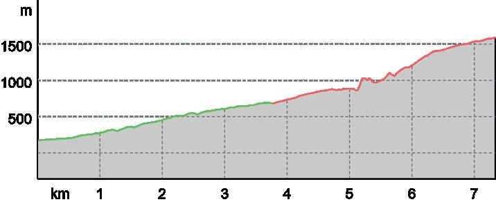
Tappa
Star-Etappe des Giro d‘Italia 2021, ein reiner Klettersteig der bei jedem, der ihn in Angriff nimmt, intensive Gefühle auslöst. Die durchschnittliche Steigung beträgt 9%, in einigen Abschnitten sogar 22%. Der Höhenunterschied beträgt auf einer Länge von 11,5 km etwas mehr als 1.000 m. Die Sega di Ala ist eine dieser epischen Steigungen, die auf der Agenda eines jeden Radfahrers nicht fehlen dür fen. Sie führt auf die Hochebene der Lessinia, wo man bei jeder Fahrt in eine Atmosphäre eintaucht, die reich an ländlichen Traditionen, Aromen und Geschichte ist.
protagonista
©
assoluta del Giro d’Italia 2021, una salita da scalatori puri che regala emozioni intense a chiunque l’affronti. La pendenza media è del 9%, ma in certi tratti arriva al 22%. Il dislivello supera di poco i 1.000 m su 11 km e mezzo di lunghezza. La Sega di Ala è una di quelle salite epiche che non possono mancare nell’agenda di ogni ciclista e porta nell’altipiano della Lessinia dove, ad ogni pedalata, ci si immerge in un’atmosfera ricca di tradizioni contadine, di sapori e di storia. Si parte dalla località Sdruzzinà direzione Sega di Ala per la strada carrabile che sale i primi 500 m per scaldare la gamba. Il primo strappo dura circa 6 km, quindi, su un tratto di circa 500 m, su cui si può rifiatare. Poi si torna a salire duramente per altri 3 km. Sono i più duri, ma vale la pena di insistere, perché si arriva in mezzo a pascoli e malghe della Lessinia. Proseguendo sulla strada dopo circa 3 km si arriva al Passo delle Fittanze che mette in collegamento il Trentino al Veneto. Star stage of the Giro d’Italia 2021, a pure climber’s climb which gives intense emotions to anyone who tackles it. The average gradient is 9%, but in certain sections it reaches 22%. The difference in al titude is just over 1,000 m over a length of 11 and a half km. The Sega di Ala is one of those epic climbs that cannot be missing from every cyclist’s agenda and takes you to the Lessinia plateau where, with every ride, you are immersed in an atmosphere rich in rural traditions, flavours and history. The start is from Sdruzzinà in the direction of Sega di Ala along the cart road that climbs the first 500 m to warm up the leg. The first climb lasts about 6 km, then, on a stretch of about 500 m, you can rest. Then it’s back to climbing hard for another 3 km. These are the hardest, but it is worth persevering, because you arrive in the midst of pastures and alpine pastures of Lessinia. Continuing along the road after about 3 km, you arrive at the Passo delle Fittanze, which connects Trentino with Veneto.
Der Start erfolgt von Sdruzzinà in Richtung Sega di Ala auf dem Karrenweg, der auf den ersten 500 m zum Aufwärmen der Strecke ansteigt. Der erste Anstieg ist etwa 6 km lang, dann kann man sich auf einer Strecke von etwa 500 m ausruhen. Dann geht es für weitere 3 km hart bergauf. Diese sind die schwierigsten, aber es lohnt sich, durchzuhalten, denn man kommt inmitten der Weiden und Almen von Lessinia an. Nach etwa 3 km erreicht man den Passo delle Fittanze, der das Trentino mit Venetien verbindet. ILGR Network Salita di Sega di Ala

DISALITASEGA DI ALA ROAD BIKE Partenza: Sdruzzinà di Ala (146 m) Coordinate: DD 45.742340, 10.980030 | DMS 45°44’32.4”N 10°58’48.1”E | UTM 32T 654027 5067326/ 04 DIFFICOLTÀ DIFFICILE LUNGHEZZA 11 km DURATA 2:46 h SALITA 1.301 m DISCESA 190 m PUNTO PIÙ ALTO 1.224 m PUNTO PIÙ BASSO 146 m asfalto 11 km


Si prosegue poi lungo via Fratelli Bronzetti tra i vigneti fino a Serravalle dove al semaforo si attraversa la SS12, quindi il sottopasso e il ponte sul fiume e si giunge alla Pista Ciclabile dell’Adige, che porta fino al Bicigrill Vo Destro. Il ritorno avviene sullo stesso percorso fino a Pilcante dove si attraversa di nuovo l’Adige sul ponte per svoltare subito dopo a destra per la strada della passerella e quindi risalire sulla pista ciclabile urbana lungo il torrente Ala di nuovo verso il centro.
Percorso ad anello nella Valle dell’Adige tra gli abitati di Ala, Serravalle e la Pista Ciclabile, parte della rete EuroVelo 7 Ciclabile del Sole. L’itinerario attraversa borghi storici e zone di pregiati vigneti, mantenendosi per la maggior parte su tratti dedicati alle biciclette o strade secondarie poco trafficate e prevalentemente pianeggianti. L’itinerario non particolarmente lungo suggerisce di approfittare delle deviazioni possibili per visitare luoghi storici e le cantine dei produttori locali. Dal centro di Ala si sale per via S. Martino, poi via A. Volta e quindi per la Strada Romana. Arrivati in prossimità della località Prati tenere la destra ed anche al bivio successivo, in direzione del Santuario di S. Valentino. Poco dopo una decisa svolta a sinistra ci immette sulla strada di collegamento tra l’abitato e il Santuario. Procediamo in direzione delle case per circa 100 m e quindi subito a destra al bivio successivo. Troviamo sulla destra i resti della grande Trincea della Grande Guerra, subito dopo il guado che porta sulla sponda opposta del rio di S. Valentino. Procediamo fino all’incrocio successivo e giriamo a destra salendo in verso la località Sgardaiolo per poi scendere al centro di S. Margherita.
Loop route in the Adige Valley between the villages of Ala, Serravalle and the Pista Ciclabile, part of the EuroVelo 7 Ciclabile del Sole network. The route passes through historic villages and areas of prized vineyards, keeping mostly on bicycle-friendly stretches or secondary roads with little traffic and mostly flat. The not particularly long itinerary suggests taking advantage of possible detours to visit historic places and the cellars of local producers. From the centre of Ala, climb up via S. Martino, then via A. Volta and then along Strada Romana. When you reach the Prati locality, keep to the right and at the next fork in the road, in the direction of the Sanctuary of S. Valentino. Shortly afterwards, a sharp left turn takes us onto the connecting road between the village and the shrine. We proceed in the direction of the houses for about 100 m and then immediately turn right at the next fork. We find the remains of the Great War trench on the right, immediately after the ford that leads to the opposite bank of the S. Valentino stream. We proceed to the next crossroads and turn right, climbing up towards the locality of Sgardaiolo and then descend to the centre of S. Margherita. We then continue along via Fratelli Bronzetti among the vineyards to Serravalle, where at the traffic lights we cross the SS12, then the subway and the bridge over the river to reach the Adige cycle path, which leads to the Vo Destro bicycle lane. The return is along the same route as far as Pilcante, where we cross the Adige again on the bridge to turn immediately right onto the footbridge road and then climb up the urban cycle path along the Ala stream again towards the centre. Rundweg im Etschtal zwischen den Dörfern Ala, Serravalle und der Pista Ciclabile, Teil des Netzes EuroVelo 7 Ciclabile del Sole. Die Route führt durch historische Dörfer und wertvolle Weinanbau gebiete und verläuft meist auf fahrradfreundlichen Strecken oder verkehrsarmen, meist flachen Nebenstraßen. Die nicht besonders lange Route legt es nahe, eventuelle Abstecher zu historischen Stätten und zu den Kellern der lokalen Erzeuger zu nutzen. Vom Zentrum von Ala aus steigt man die Via S. Martino hinauf, dann die Via A. Volta und dann die Strada Romana entlang. Wenn Sie die Ort schaft Prati erreichen, halten Sie sich rechts und fahren an der nächsten Abzweigung in Richtung der Wallfahrtskirche S. Valentino. Kurz darauf biegen wir scharf links auf die Straße ab, die das Dorf mit dem Heiligtum verbindet. Wir gehen etwa 100 m in Richtung der Häuser und biegen dann an der nächsten Abzweigung sofort rechts ab. Die Überreste des Schützengrabens aus dem Ersten Weltkrieg befinden sich rechts, gleich nach der Furt, die zum gegenüberliegenden Ufer des Baches S. Valentino führt. An der nächsten Kreuzung biegen wir rechts ab und steigen hinauf zur Ortschaft Sgardaiolo und dann hinunter ins Zentrum von S. Margherita. Weiter geht es über die Via Fratelli Bronzetti zwischen den Weinbergen nach Serravalle, wo wir an der Ampel die SS12 überqueren, dann die Unterführung und die Brücke über den Fluss, um den Etsch-Radweg zu erreichen, der zum Vo Destro-Radweg führt. Der Rückweg erfolgt auf der gleichen Strecke bis nach Pilcante, wo wir die Etsch auf der Brücke überqueren, um sofort rechts auf die Fuß gängerbrücke abzubiegen und dann auf dem städtischen Radweg entlang der Ala wieder in Richtung Zentrum zu fahren.
DICICLABILEFONDOVALLE CICLOTURISMO - ROAD BIKE Partenza: Ala (171 m) Coordinate: DD 45.758295, 11.006038 | DMS 45°45’29.9”N 11°00’21.7”E | UTM 32T 656006 5069149/ 05 DIFFICOLTÀ FACILE LUNGHEZZA 27 km DURATA 2:10 h SALITA 155 m DISCESA 176 m PUNTO PIÙ ALTO 248 m PUNTO PIÙ BASSO 130 m asfalto 12,1 km sentiero naturalistico 0,2 km strada sterrata 8,5 km strada 6,3 km


/ DOVE DORMIREMANGIAREAIVELLUTAI Via Mario Soini, 34 - Ala Cell. 347 3822028 AL GHIOTTONE Corso Passo Buole, 15 - Ala Tel. 0464 671546 AL GIARDINO Via Ronchiano, 1 - Ala Tel. 0464 671058 AL PICCHIO Contrada Sdruzzinà, 20 - Sdruzzinà Tel. 0464 672825 CÀ DEL GIGLIO Piazza Vittorio Veneto, 1 - Pilcante Tel. 0464 680035 CAMPING AL FAGGIO Località Fratte - Lessinia Tel. 0464 670162 CÀ ULIVI Località Sgardaiolo, 20 - Santa Margherita Cell. 389 8056374 CENTRALE Via E. Deimichei, 24 - Ronchi di Ala Tel. 0464 671033 CENTRALE Località Sega di Ala, 4 - Lessinia Cell. 348 0337996 EL POJO Via Biasi, 5 - Ronchi di Ala Tel. 0464 671736 GIULIO MOUNTAIN B&B Località Le Ville, 51 - Lessinia Cell. 348 3047962 LA CAIGOLA Località Caigole, 9 - Ala Cell. 348 3740950
LA PINETA Corso Passo Buole, 38 - Ala Tel. 0464 671460 LOCANDA ALPINA Località Sega di Ala - Lessinia Tel. 0464 670143 LUISA Via Trento, 65 - Santa Margherita Tel. 0464 696079 MALGA RIONDERA Località Riondera - Lessinia Cell. 348 1454784 MASO ROCCA Località Maso Rocca - Ronchi di Ala Cell. 338 6387279 MONTI LESSINI Località Sega di Ala - Lessinia Tel. 0464 671253 OSTERIA CARNERA Piazza Buonacquisto, 4 - Ala Tel. 0464 671900 RELAIS DIVINO Località Coleri, 10 - Coleri Tel. 0464 696647 RIFUGIO MARIO FRACCAROLI Alta Val d’Illasi - Ala Cell. 353 4408353 RIFUGIO PASSO PERTICA Località Passo Pertica Cell. 328 9689090 RIFUGIO POMPEO SCALORBI Località Passo della Pelagatta Tel. 045 7847029 SHANGRILA Corso Passo Buole, 13 - Ala Tel. 0464 672530 SUSHI JOY Corso Passo Buole, 5/A - Ala Tel. 0464 671693 WINE BAR BACCO 12 Località Villetta - Chizzola Cell. 348 5568295 ZUGNA Corso G. Cantore, 34 - Serravalle Tel. 0464 696205
© M. SimoniniLessinia

© T.MalgaPrugnolaSega FOTO IN COPERTINA©D.Lira © T. Prugnola PROGETTOAndreaGRAFICOMunari

INFO Azienda per il Turismo Rovereto Vallagarina e Monte Baldo T. +39 0464 www.visitrovereto.itinfo@visitrovereto.it430363