TITLE : DIWATA 1 FIRST FILIPINO SATELLITE How Diwata-2 is better than PH's first satellite, Diwata-1 Ariston Gonzalez, a Diwata-1 engineer, reveals that the Diwata-2 project, slated for deployment in Q2 2018, is running 'on time'
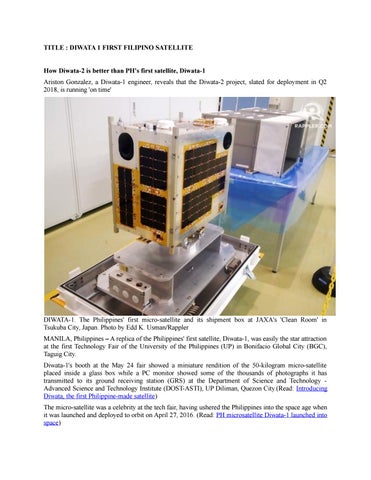
DIWATA-1. The Philippines' first micro-satellite and its shipment box at JAXA's 'Clean Room' in Tsukuba City, Japan. Photo by Edd K. Usman/Rappler MANILA, Philippines – A replica of the Philippines' first satellite, Diwata-1, was easily the star attraction at the first Technology Fair of the University of the Philippines (UP) in Bonifacio Global City (BGC), Taguig City. Diwata-1's booth at the May 24 fair showed a miniature rendition of the 50-kilogram micro-satellite placed inside a glass box while a PC monitor showed some of the thousands of photographs it has transmitted to its ground receiving station (GRS) at the Department of Science and Technology Advanced Science and Technology Institute (DOST-ASTI), UP Diliman, Quezon City.(Read: Introducing Diwata, the first Philippine-made satellite) The micro-satellite was a celebrity at the tech fair, having ushered the Philippines into the space age when it was launched and deployed to orbit on April 27, 2016. (Read: PH microsatellite Diwata-1 launched into space)
But where does the DOST's satellite program go from here? Thankfully, Ariston Gonzalez, one of the "Magnificent 9" (the group of Filipino engineers who pioneered the design, development, and assembly of Diwata-1) was on hand to satisfy this curiosity. Diwata-1 and beyond Gonzalez fielded questions from visitors about the Philippines' maiden eye-in-the-sky. He also provided some updates on Diwata-1's "sibling," Diwata-2, now under development in Japan. Gonzalez was in Japan a week before the fair, where he was involved with the design and development of the country's second satellite, targeted for deployment in the second quarter of 2018. "For now, we are still at the structural development, and the evaluation of components together, [and] testing. It is on time, really. Hopefully, in the next few months we can start integrating the engineering model. The engineering model is the next critical phase before we proceed to the flight model, which is the final one that we will send to JAXA," said Gonzalez. JAXA stands for Japan Aerospace Exploration Agency, with which DOST collaborates for its Philippine Scientific Earth Observation Micro-satellite (PHL-Microsat) Program along with UP and two Japanese academic institutions, Tohoku University (TU) and Hokkaido University (HU). Naturally, Diwata-2 has some improvements over its older sibling. Diwata-2's payload includes 4 state-of-the-art cameras like 1. However, Diwata-2, is the only one with a radio for better communication. Diwata-2 will also be sent to an orbit 213 kilometers higher than its older sibling (orbiting at 400 kilometers above earth) for a longer life. Diwata-1's useful life is expected to cease in November 2018 as she gives in to decay and the gravitational pull of the planet. Diwata-2, while an improvement, will have the same mission as 1: to monitor the country's agricultural landscape and environment. The new model is designed to be able to monitor things more closely, aided by its "sun-synchronous orbit." At the celebration of Diwata-1's first anniversary in orbit, Dr. Gay Jane Perez – among the project leaders at the PHL-Microsat Project – explained the benefits of the Diwata-2's sun-synchronous orbit: "With Diwata-2 being sun-synchronous, we get passes in a more periodic way. So, if we have an area, for example, experiencing drought, we can monitor the development on this specific area." Essentially, the new feature improves the ability to monitor. Gonzalez, at the tech fair, said that they're planning to put up a second GRS in Davao City to which Diwata-1 and 2 will be able to transmit photographs. The first GRS (named "PEDRO") is at the DOSTASTI facility in UP Diliman, Quezon City. Diwata-1 has currently captured thousands of photographs, taken over the course of 5,000 passes around Earth, moving at 7 kilometers per second. The Diwata-1 photos are available for free to both government agencies and private individuals at the PHL-Microsat website. The Philippines' micro-satellite program Diwata-1 and 2 are part of DOST's 10-year P24-billion Space Technology Development (STD) Program – presented to the cabinet in January 2017 by DOST secretary Fortunato de la Peña, and approved by President Rodrigo Duterte. The agreement is aimed at sending two satellites in space, with Diwata-1 being the first. At present, 9 Filipino engineers from UP and DOST are at the helm for the continuation of the PHLMicrosat program: Delburg Mitchao and Ellison Castro at HU; Leonard Paet at TU; Adrian Sales and Joven Javier at the Kyushu Institute of Technology (KyuTech); research student Gerwin Guba; Julie Banatao and Paolo Violan, who will also be enrolled soon at a Japanese academic institution; and Ariston Gonzalez, who will be stationed at the DOST-ASTI.
Gonzalez moved back to the Philippines after finishing his Master of Science in Aerospace Engineering at TU in March 2017. Diwata-1's aforementioned "Magnificent 9" are Harold Bryan Paler, John Leur Labrador, Benjamin Jonah Magallon, Kaye Kristine Vergel, Julian Marvick Oliveros, Juan Paolo Espiritu, Ariston Gonzalez, Delburg Mitchao and Gerwin Guba.
MAGNIFICENT 9. This group of Filipino Diwata-9 engineers are so dubbed for being pioneers in Philippine satellite-building. Photo by Edd K. Usman/Rappler Further explorations A third micro-satellite is a distinct possibility. Dr. Carlos Primo David, executive director of the Philippine Council for Industry, Energy and Emerging Technology Research and Development (DOST-PCIEERD) told Rappler recently that DOST is planning to build Diwata-3. Nothing is final yet, he clarified, but they are in discussion with Japanese engineers for a 3rd Diwata. With these projects, Gonzalez said that STEM (science, technology, engineering and mathematics) is "very much alive in the Philippines." "[If] more young minds can engage in this – they have a place to go. In fact, the place they can go is very high: space. If they can stick to it...there are lots of things going on in the environment, and lots of ongoing developments they can contribute to," Gonzalez said. Introducing Diwata, the first Philippine-made satellite
Diwata is one of two micro-satellites the Philippines hopes to launch in 2016 and 2017. It is expected to improve weather forecasting, disaster management, forest protection and other public services.
UP IN SPACE. Diwata, the Philippines' first microsatellite, may look like this, the 1U CubeSat ESTCube1 which was developed by Estonia. Image from Wikipedia MANILA, Philippines – The Philippines will launch its very own satellites into space in 2016 and 2017, the Department of Science and Technology (DOST) announced on Tuesday, March 10. A government project dubbed the Philippine Scientific Earth Observation Micro-Satellite (PHL-Microsat) Program aims to send two micro-satellites into space to assist in disaster management programs, weather forecasting, agriculture, fisheries, forest protection, mining, and even the protection of cultural and historical sites, said Dr Joel Marciano, the program leader. The first micro-satellite, PHL-Microsat-1, nicknamed Diwata, will be launched into space in 2016 from the International Space Station (ISS), a large, habitable satellite orbiting the Earth. The second one, PHL-Microsat-2, will be launched in 2017. It has not been given a nickname yet. Aside from the two satellites, a ground receiving station called the Philippine Earth Data Resources Observation (Pedro) Center will be established under the program. To be built at the Subic Freeport in Zambales, the facility will receive the data and images captured by the satellites and process them into information that can then be disseminated to government agencies and used for public services. A research laboratory to be based at the University of the Philippines Diliman will be tasked to develop improvements to the program. It will also have direct access to information processed by the ground receiving station.
The 3-year project will cost a total of P840.82 million ($19 million). Of this, P324.8 million ($7.3 million) will be shouldered by the Philippine government while P515.92 million ($11.6 million) will be shouldered by two Japanese universities, Tohoku University and Hokkaido University. Funds from the Philippines have been programmed by the Department of Budget and Management until 2017, said DOST Undersecretary Rowena Cristina Guevara. The two schools are currently training Filipino scientists and engineers to design and build the components of the micro-satellite and receiving station. The Filipino scientists, through a government scholarship program, have been in Japan since October 2014, working on their masters degree which focuses on the development of the satellites. WAITING FOR DIWATA. Philippine microsatellite program leader Joel Marciano (left) and DOST Undersecretary Rowena Cristina Guevara (middle) explain to media the possible uses of the microsatellites The Tohoku and Hokkaido universities have rich experience in satellite programs. They developed Japan's micro-satellite, Rising-2. Japan also benefits from one of the most advanced space research institutes in the world, its Japan Aerospace Exploration Agency (JAXA). What is a micro-satellite? A micro-satellite is a small satellite typically with a mass of 10 to 100 kilograms. PHL-Microsat 1 and 2 will each have a mass of 50 kilograms and will traverse a Low-Earth Orbit – 400 to 420 kilometers from the ground – at a speed of 7 kilometers per second, said Marciano. It will carry 3 main payloads or instruments used for measurement and detection. A High Precision Telescope can help determine the extent of damage from disasters, like typhoons and volcanic eruptions. It can also monitor changes in cultural and natural heritage sites, like the Cordillera Rice Terraces or Mayon Volcano. The Spaceborne Multispectral Imager with LCTF will be able to monitor changes in vegetation due to climate or pests. By assessing biomass, it will also be able to detect how healthy our oceans are which will help ensure fishing grounds are not overexploited. A Wide Field Camera, meanwhile, will help scientists better observe cloud patterns and thus be able to more accurately predict weather disturbances. Aside from these uses, the micro-satellites will aid in forestry management, wild fire management, and geography. Before Diwata, the Philippines had control of two communication satellites Agila-1 and Agila-2. These satellites, which were privately-owned, were not capable of taking images. They were also built by foreigners and not Filipino scientists and engineers. Savings for the gov't Diwata, once launched, is expected to pass 4 times a day over the Philippines, spending 6 minutes over the country per pass. It will capture 900 images per pass, thus it can capture up to 3,600 images daily. It will then transfer the images to the ground station in Subic in speeds of up to 2.4 Mbps.
RECEIVING DATA. The ground receiving station to be established in Subic is likely to have a satellite receiving dish similar to this one To some, purchasing two satellites may seem extravagant for a developing country, but Guevara says it is actually more economical given how much the government currently spends to buy satellite images. The potential savings are a major reason for the government's decision to embark on the program. "Just to give you an idea, 30 minutes of satellite data costs P58 million ($1.3 million). We spend P2 billion ($45.1 million) a year to acquire satellite imagery. With our own satellite, we can get data 365 days a year and we can task the satellite to take a picture of a particular location," she said. The Japanese support the project because it will help aid in the Japanese-led initiative of establishing the Asian Microsatellite Consortium (AMC). The consortium already includes micro-satellites of Indonesia, Vietnam, and Thailand. "We want to have better coverage. We can establish, one day, the common methodology and we can use it together. If we use separate type of sensors, we cannot share the data," said Professor Yukihiro Takahashi of Hokkaido University's Space Mission Center. Data about the Philippines would help Japan and the consortium improve its ground evaluation. The Philippines, said Takahashi, is a very important country due to its geographic location, being a tropical country at the frontlines of typhoons from the Pacific Ocean.
Guevara said there is still no set month for Diwata's launch and that, given the queue at the ISS, it is likely the date of the launch will only be scheduled a month before. Launches of micro-satellites typically cost P57 to 75 million ($1.3 million-$1.7 million) per launch, she said. The planned micro-satellites mark the country's venture into space technology, with the goal of one day developing a full-fledged Philippine Space Agency. (READ: Is PH ready for liftoff?) Is the government's head in the clouds for even contemplating space projects given other humanitarian problems plaguing the Philippines? Guevara begs to differ. "Poverty alleviation is the reason why we are doing this. If we use the data from Diwata, it will tell us that you should plant this type of crop to increase productivity of farmers. If you save people from disaster, that is also poverty alleviation." INSTRUMENTS Diwata-1 has three scientific instruments: the High Precision Telescope (HPT); Space-borne Multispectral Imager (SMI) with Liquid Crystal Tunable Filter (LCTF); and the Wide Field Camera (WFC). Diwata-1 also has one engineering control instrument, the Middle Field Camera (MFC). The HPT – with a ground sample distance (GSD) of 3 metres (9.8 ft) at 400 kilometres (250 mi) – is currently being studied on how it can be used to monitor the extent of damages from natural disasters such as typhoons. It is also equipped with four CCDs for the red, blue, green, and near infrared regions of light. The SMI with LCTF – with a GSD of 80 metres (260 ft) at 400 kilometres (250 mi) – is currently being studied on how it can be used in measuring vegetation changes and phytoplankton biomass in Philippine waters. The instrument is equipped with two CCDs for both visible (420–700 nm) and near infrared (650– 1050 nm) regions with a 13 nm interval. The WFC – which has a GSD of 7 kilometres (4.3 mi) and a panchromatic CCD with a field view of 1800 × 1340 – is used to give visualizations of large-scale cloud patterns and distributions. Diwata-1 can be used to take daily images using the WFC in case of any upcoming large-scale weather disturbances, such as storms or typhoons. The calibration of the attitude determination algorithm will be handled by the MFC. The instrument is equipped with a colored CCD and expected GSD of 185 metres (607 ft), and will also aid in locating images captured by the HPT and SMI
PUBLISHED: APOLINARIOMAJAIT FROM: WIKIPEDIA/ RAPPLER