Wildlife Corridor Compatible Communities in Florida: From Concept to Practice


Jason Lauritsen
Lindsay Stevens


Takeaways
From Us:
1. What is the Florida Wildlife Corridor?
2. What approaches are being taken to protect and enhance the Corridor?
3. What tools are resources are available?
4. How might you engage in this effort?
From You:
1. How does the Florida Wildlife Corridor advance planning efforts in my community?
2. How does the Florida Wildlife Corridor impact your community/work/project(s)?
3. How might the Florida Wildlife Corridor engage with stakeholders?
4. What tools and resources might be useful in your community?
Corridor CompatibilityCommunity Development and Design
The How and Where We Develop (Or Don’t)

- First year of work
- Core team of representatives
- Public, private, landowners, NGOs
Rationale
Aim: Corridor Compatible Communities Guidelines should accommodate growth while promoting the retention and enhancement of wildlife corridor functions to sustain a high quality of life for Floridians and a diverse and healthy native ecosystem.
Guidelines should
● Aid stakeholder decision making re: where and how we grow.
● Be widely used, practical, and advance conservation outcomes
● landowners, regional planning councils, developers,county planners, elected officials, private consulting firms

33 million people by 2070
Connecting, protecting and restoring the Corridor
How we grow makes all the difference. Protecting the Corridor can be done even as our population grows. However, it will require careful and intentional planning around the vital ecological connections illustrated by the Florida Wildlife Corridor.

Wildlife Corridors
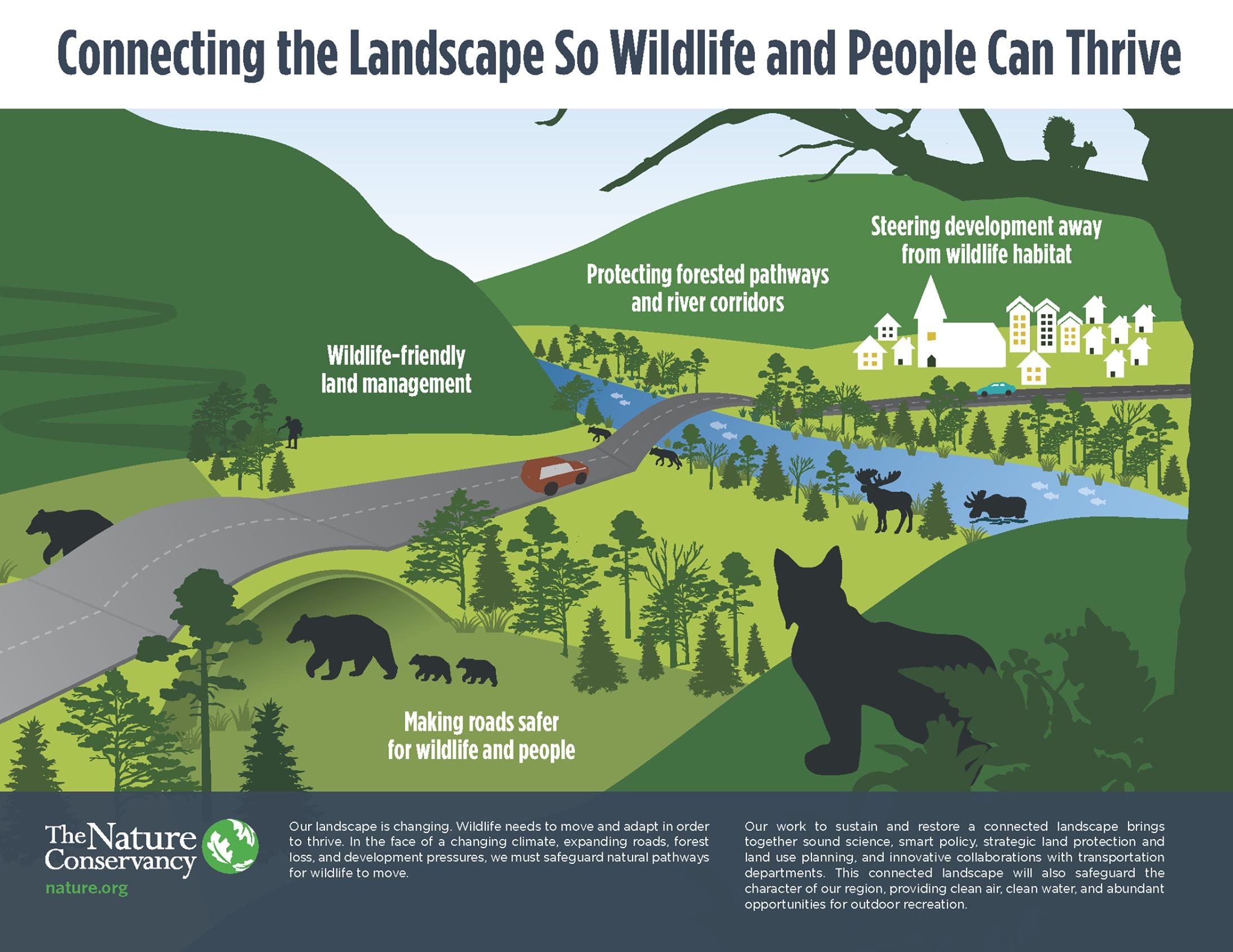
The Florida Wildlife Corridor

The Corridor connects 75 State Parks
..and 32 State Forests
The Corridor is home to over 1,700 species
..60 of these are considered “at risk”
The Corridor supports at least 114,000 jobs
..and provides $30 billion in annual revenue
Scientific foundation
Nodes of concentrated ecological value exist in each landscape at all levels in the biological hierarchy. Integration of these high-quality nodes into a functional network is possible through the establishment of a system of interconnected multiple-use modules.*

 The Reserve Network developed by Noss in 1994 preceded and informed the FEGN model.
Noss & Harris 1986
*Noss, Reed & Harris, Larry. (1986). Nodes, networks, and MUMs: Preserving diversity at all scales. Environmental Management. 10. 299-309.
The Reserve Network developed by Noss in 1994 preceded and informed the FEGN model.
Noss & Harris 1986
*Noss, Reed & Harris, Larry. (1986). Nodes, networks, and MUMs: Preserving diversity at all scales. Environmental Management. 10. 299-309.
Florida Ecological Greenways Network (FEGN) model was created using…

•26 Priority Ecological Area data layers
•7 connectivity models
These data were used to identify a series of hubs, or core areas, of large, landscape-scale ecological significance, and a network of corridors connecting the hubs into a statewide ecological greenways system.
The Florida Wildlife Corridor is composed of the top 3 priority layers from the FEGN model.
75 State Parks
171 Major* Springs
32 State Forests
18 million acres
Unprotected: 8 million acres
Protected: 10 million acres

Acquisition Opportunities
Project Acres
Florida Forever - 1.8 million
RFLPP - 163,000

“Right Place”
Not every acre of the Corridor looks like the next state park


* Connecting the Florida Wildlife Corridor – Economic Study 2021
Land conversion along the Lake Wales Ridge in this region has reduced connectivity between the Green Swamp and the Everglades Headwaters.


Leaving one remaining viable link between Lake Louisa State Park and Reedy Creek

G H
Considerations for Critical Pinch Points


D
Design Guidelines

for “Right Design”


Corridor Compatible Communities
Guide responsible development and management of land in a manner which sustains local wildlife populations and their habitat needs.
Guiding Principles

Jointly plan development and conservation together, respecting core conservation areas, allowing for the provision of connected wildlife corridors and decreased fragmentation.

1 2
Strengthen the middle tier of land conservation, which offers the greatest potential for better integration of human development with wildlife habitat needs.
Guiding Principles
4

Reduce environmental impacts of land development while simultaneously protecting the rights of property owners, and enable development of high quality projects.

3
QUALITIES
DESIGN WITH NATURE
Compatible Community
Qualities
DESCRIPTION
Is the site planned and designed with careful regard to ecology? Please describe.
COMMUNICATION AND EDUCATION OF WILDLIFE CONNECTIVITY
HABITAT CREATION
HABITAT RESTORATION
IMPACTS ON WATER QUALITY
What efforts are made to teach the public about the wildlife corridor?
Are habitats created where previously there were none? If yes, describe the habitat created.
Are disturbed landscapes restored and revitalized? If yes, describe restoration and revitalization projects.
What methods are in place to ensure no negative impact on water quality resulting from the developments regular drainage patterns?
COLLABORATION WITH CONSERVATIONISTS
METRICS/DATA COLLECT
How and which conservationists are involved with the monitoring of the development and the adjacent wildlife corridor?
ENVIRONMENTAL COMMUNITY STANDARDS
NEARBY WILDLIFE CONSERVATION LANDS
LAND USE COMPATIBILITY
NEGATIVE EDGE EFFECTS
APPROPRIATE BUFFERS
What means and methods are utilized to collect information on wildlife impact from the development site?
What design management standards are recommended or enforced community-wide?
Are there any connections to adjacent conservation lands? If yes, please list them.
Is the development site compatible with adjacent land uses. If yes, describe how. If not, what conflicts do you experience?
What problems have been encountered at the edge of the development and wildlife corridor?
Is there an ample and effective buffer? What buffer zones have been included in the development. Please share short descriptions and dimensions of those included.
PLANT COMMUNITIES
Are there diverse habitats throughout the community? Please describe the plant communities and habitats provided within the development.
TRANSPORTATION INFRASTRUCTURE
IMPACTS
Were new roads constructed to connect the community to this development? If so, what level of service was planned for these roadways?
Corridor
Other Design Considerations
Alligator Alley road named after adjacent marshes which are home to many Floridian alligators
used by small to large mammals, reptiles, bugs and more
Existing Conditions
barriers these fences prevent wildlife from going onto the road used by small to large mammals
used by small to large mammals, reptiles, bugs and more
vegetation if the vegetation becomes overgrown, access and visibility of the tunnel may be lost


dry passage
embankment allows for animals to cross during the wet season when the path is underwater

Other Design Considerations
Improving Navigability
logs by laying down logs with concrete footings along the water body, animals are able to easily get across


concrete
where logs are imperfect and have cracks between them that animals can trip through, concrete provides a stable surface to cross used by bears, panthers and other large mammals
Corridor CompatibilityCommunity Development and Design
The How and Where We Develop (Or Don’t)
- Moving forward - Frame out guidelines
- On the ground collaboration - ???
Find out more - Data, links and information:
CLCP/UF - Florida Wildlife Corridor boundary files
https://conservation.dcp.ufl.edu/fegnproject/
TNC Resilience and Connected Landscapes
http://nature.ly/TNCResilience
The Florida Circuit Model, v. 1.1 — a new statewide map of local habitat connectivity
https://archbold-cms.payloadcms.app/media/FLcircuitModel_1_1.pdf
Florida Wildlife Corridor Foundation Resource Page
https://floridawildlifecorridor.org/partners-3/

Takeaways
From Us:
1. What is the Florida Wildlife Corridor?
2. What approaches are being taken to protect and enhance the Corridor?
3. What tools are resources are available?
4. How might you engage in this effort?
From You:
1. How does the Florida Wildlife Corridor advance planning efforts in my community?
2. How does the Florida Wildlife Corridor impact your community/work/project(s)?
3. How might the Florida Wildlife Corridor engage with stakeholders?
4. What tools and resources might be useful in your community?
