1 minute read
Understanding frozen ground


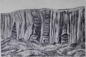
Scientific world was deeply impressed by the first photographs of huge ground ice wedges published by Baron Eduard von Toll in 1897. He speculated that these formations were relicts of glaciers and introduced terms like fossil ice“ and “ ice rock” (Steineis) in geocryology [22]. Alexander von Bunge did not agree With him. In 1902, Bunge was the first one to publish a hypothesis of the genesis of ground ice by thermal contraction.
The western world was first informed of the permanent frozen ground in Siberia by J.G. Gmelin who had reported about such a phenomenon in Yakutsk, but Leopold von Buch (1774–1853) was doubtful and considered impossible that plants were growing in this region on the permanently frozen soil. On the initiative of the merchant of the Russian-American Company, Fedor Shergin, a shaft was dug in Yakutsk to get drinking water. To Shergin´s surprise, they did not reach water. Ferdinand von Wrangell, new Governor of the Russian America, insisted in 1829 on continuation of digging at the expense of the Company in order to study the frozen ground underneath Yakutsk. Between 1828 and 1837, they reached the depth of about 116.5 m, but the soil was continuously frozen. The shaft appeared to be of great importance for further geocryological studies. First measurements of the frozen soil temperature were carried out therein in April 1829 by the German physicist Adolph Erman (1806–1877). Down to the bottom of the shaft (about 15 m deep at that time) he recorded continuously –7.5° C in deeper parts, which corresponded well to the mean annual temperature in Yakutsk of –7.4° C.
Advertisement
This result can be regarded as the first record of the depth of permafrost of “Zero Annual Amplitude“. Erman expected liquid water at the depth of about 190 m. Shergin´s measurements published in 1838 indicated temperatures of ~–0.6° C at the bottom of the shaft. Several scientists were doubtful about Shergin´s data. Regular measurements in the Shergin shaft (1844–1846) were carriedout by A. Th. von Middendorff. He reported on a bottom temperature –3.0° C and published his detailed geothermal observations, including data on the thermal conductivity of soils – a result of geothermal measurements in the Shergin shaft.
first photographs of huge ground ice wedges published by Baron Eduard von Toll