News
RV Investigator voyage yields surprising results Warrick Glynn & David Reilly
Integrated Marine Observing System, Antarctic Climate and Ecosystems Cooperative Research Centre Data gathered from the first scientific voyage of Australia’s new National Marine Facility, the RV Investigator, is expected to provide unprecedented insights into the ways climate change is affecting the physical, chemical and biological properties of the Southern Ocean. Cloud formations are an important factor in climate predictions yet they remain the single greatest source of uncertainty in current models used in forecasting. The RV Investigator carries highly specialised weather radar for measuring clouds. An upward looking radar was also installed specifically for this voyage by the Bureau of Meteorology, under the leadership of Dr. Alain Protat. The Bureau radar is able to send 800 microwave pulses every second and collect data within a 150 km radius of the ship and 20 km into the atmosphere. One of the most surprising and interesting early findings came when the research team pointed the radar into the Southern Ocean sky. Information from the radar, combined with data from a newly deployed air-sea flux mooring and images from a satellite passing overhead revealed something previously unknown.
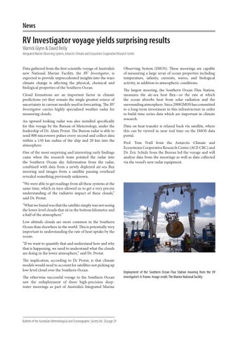
Observing System (IMOS). These moorings are capable of measuring a large array of ocean properties including temperature, salinity, currents, waves, and biological activity, in addition to atmospheric conditions. The largest mooring, the Southern Ocean Flux Station, measures the air-sea heat flux—or the rate at which the ocean absorbs heat from solar radiation and the surrounding atmosphere. Since 2008 IMOS has committed to a long-term investment in this infrastructure in order to build time series data which are important in climate research. Data on heat transfer is relayed back via satellite, where this can be viewed in near real time on the IMOS data portal. Prof. Tom Trull from the Antarctic Climate and Ecosystems Cooperative Research Centre (ACE CRC) and Dr. Eric Schulz from the Bureau led the voyage and will analyse data from the moorings as well as data collected via the vessel’s new radar equipment.
“We were able to get readings from all these systems at the same time, which in turn allowed us to get a very precise understanding of the radiative impact of these clouds,” said Dr. Protat. “What we found was that the satellite simply was not seeing the lower level clouds that sit in the bottom kilometre and a half of the atmosphere.” Low altitude clouds are more common in the Southern Ocean than elsewhere in the world. This is potentially very important in understanding the rate of heat uptake by the ocean. “If we want to quantify that and understand how and why that is happening, we need to understand what the clouds are doing in the lower atmosphere,” said Dr. Protat. The implication, according to Dr Protat, is that climate models would need to account for satellites not picking up low-level cloud over the Southern Ocean. The otherwise successful voyage to the Southern Ocean saw the redeployment of three high-precision deepwater moorings as part of Australia’s Integrated Marine
Bulletin of the Australian Meteorological and Oceanographic Society Vol. 28 page 29
Deployment of the Southern Ocean Flux Station mooring from the RV Investigator’s A-Frame. Image credit: The Marine National Facility