11 minute read
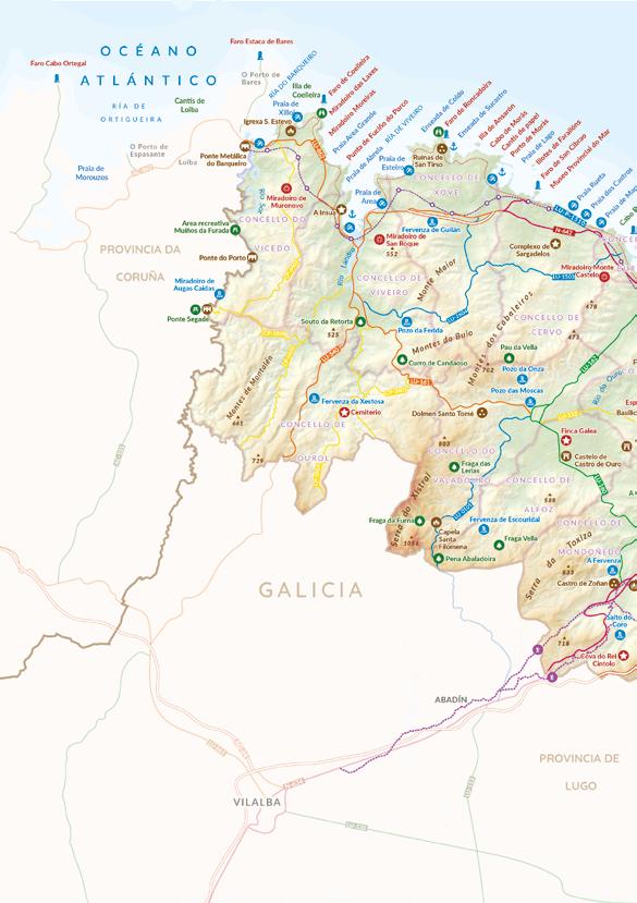
Waterfalls (“fervenzas”) in A Mariña Lucense


A Férrea, A Pontenova
A visit to the waterfall, 3 km from A Pontenova, is included in the A Férrea route, to be done on foot, or by car. Leave A Pontenova via the N-640 to Ribadeo and at the roundabout at the edge of the town, head towards the industrial park and take the main street right to the end, where the Recense warehouse is located. Turn left, following the signs for the route, and at the next crossroads, keep turning right until coming across a minor road leading to the start of the route, at the Torrentas bend. Nearby is a parking facility 300 m from the foot of the waterfall.
Advertisement
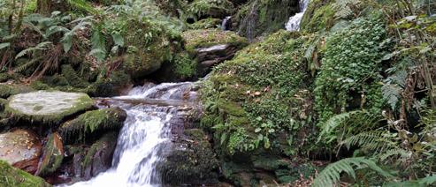
The Parada stream flows downhill with force, forming cascades and leaving foam and spray in its wake. The most important is A Cascada de A Férrea, which has two 8-metre drops, whose volumes change dramatically depending on the season.
Fervenza de Viloalle, Mondoñedo
Located 3 km outside Mondoñedo, this waterfall is signposted from the town. Take the LU-160 to Alfoz and, if going by car, take a turning on the left after approximately 2 km, cross the bridge and take the narrow track on the left for 300 m to a small parking facility. If going on foot, on the LU-160 there is an information panel (opposite a fountain), from where a path departs, leading to the waterfall via an attractive footbridge.
The River Tronceda, originating in the O Xistral mountain range and an affluent of the Masma, forms a series of fast-flowing cascades and pools. There is a recreation area with a natural pool surrounded by large rocks and eucalyptus trees, and a fresh water pool, as well as picnic area and a wooden bridge, called “Ponte dos Carabullos”. This spot is included in a route that pays tribute to the writer Leiras Pulpeiro, and an old electric power plant nearby is being restored.
Salto do Coro, Mondoñedo
Leaving Mondoñedo via the neighbourhood known as Os Muíños, take the DP-3102 in the direction of Cova do Rei Cintolo. After 2.4 km, there is a turn-off on the right. Take this narrow track for 1 km, after which you will have to continue on foot along a path that climbs steeply for 600 m. The waterfall is across a bridge and some steps. There is not much space to park and, therefore, we recommend walking from Mondoñedo, following the Ruta da Auga (Water Route) which starts at the Fonte Vella, in the town centre, or taking the same route as by car, watching out for the traffic, from Os Muíños (around 50 minutes).
As the Escourido “rego” (stream) flows through As Bouzas hills, it comes to a 10-metre drop, forming a small pool of crystal-clear water known as Salto do Coro. A magical place, reached on foot along a dirt, stone and wooden path and surrounded by autochthonous flora typical of a riverside landscape: ferns, lichens, moss, alders, hazel alders and walnut trees.
Escouridal, O Valadouro-Alfoz
Access to this waterfall is signposted. On the LU-160 leading out of Seara (capital of Alfoz), take the LU-CP-0202 at the traffic lights, towards the Casa do Concello” (Town Hall) and continue for approximately 8 km where it meets the LU-P-0204. Turn right, and after about 3.5 km, turn right at the turn-off marked Cadramón / Escouridal (DP-6360), and continue for a further 1.2 km to an information panel. A few metres further along, on the left, is a path with signs to follow on foot. Visitors can also park at this spot. The path ends with some wooden steps leading to the foot of the waterfall, which is easily visible. Those who want to get a little closer and see it in all its splendour can climb across some rocks with the help of a rope, being mindful of the danger.
The Escouridal waterfall is formed as the River Guilfonso (an affluent of the River Ouro) winds its way downwards over large granite rocks to plunge 80 m below. The best time of the year to see this spectacular waterfall is in spring, when the volume of water is at its highest, having collected the rainfall that has accumulated in O Xistral mountain range.
Pozo da Onza, O Valadouro
Leave Ferreira de Valadouro via the LU-162 to Burela, and 1.4 km after the roundabout, turn left onto the LU-P-1502 to “Ferreira”. 200 m further along is a sign for Pozo da Onza, on the right-hand side. Continue for a further 1.5 km (the road narrows at San Cristovo) until you reach a crossroads, where you turn left downhill for another 100 m. There is no specific area for parking, but it is possible to leave your car on the roadside. Continue on foot for 200 m along a signposted path, on the left bank of the river.
Pozo da Onza is a deafening waterfall in the borough of O Valadouro and the prettiest part of the Ruta dos Pozos (Route of the Pools). It forms in Val dos Infernos stream, which is an affluent of the River Ouro, is surrounded by quartzites camouflaged among the moss and ferns, and has a drop of some 15 m into a transparent pool.
Pozo da Ferida, Xove-Viveiro
Access to this waterfall is via the LU-P-2604 and it is signposted from Xove and Viveiro. It is situated approximately 12 km from Xove, following the LU-P-2604, and 14 km from Viveiro, taking first the LU-540 to Ourol/ Muras, then the turn-off for the LU-161 (Viveiro-Mondoñedo) and lastly the turn- off for Valcarría / A Ferida via the LU-P-6607 / LU-P-2604.
The turn-off from the LU-P-2604 is signposted, the route continuing along a surfaced track until it reaches a crossroads with a sign for the pool. Cars can be left here, and visitors can continue on foot for approximately 1.2 km (or a 20-minute walk), following the signs for the pool. The surfaced track becomes a dirt track and about 900 m along (a 15-minute walk), a path branches off to left, leading to the waterfall, a further 1.2 km (or 20-minute walk) away. At the end of the path, to the right, is an abandoned mill and a lovely natural pool formed by the river. 300 m along a path to the left is the waterfall, which drops vertically into the pool below.
The Pozo da Ferida is a waterfall situated between the boroughs of Xove and Viveiro. At this spot, the River Loureiro, a tributary of the Landro, is naturally channelled through the rocks before plunging into the circular pool below, surrounded by autochthonous vegetation, birches, alders, willows and oak trees, as well as some yew trees, holly and ferns. A beautiful place, shrouded in legend.
Fervenza de Guilán, Xove
Take the LU-P-2604 signposted at a crossroads on the LU862 in the centre of Xove. 600 m further along, having passed under the North Coast CG.2.3 road, on the right you will see a sign for the path to the waterfall, and have to leave your car here. The forest track crosses through eucalyptus plantations, parallel to the abovementioned North Coast road, and there are signs for the waterfall all along the 2-km walk, at which point it branches off to the left, the now stony path climbing quite steeply. The final turn comes after a 250-metre climb (as of November 2020, this is not signposted), beside a pylon, and the waterfall is 300 m from here.
There is a slightly shorter route to the waterfall, which starts in the industrial park but which is not currently signposted. In this case, take the LU-862 from Xove to Viveiro. Take the first turn-off on the left at km 94, just before Camba industrial park, follow the dirt track for around 1 km and, when it starts to climb, take the stone path on the right. A final turn-off to the right leads to the waterfall.
The Guilán stream flows gently downhill from its source until the area known as A Panda, where it becomes steeper. At this spot, the water plunges 70 m into the pool below, forming a beautiful, wide, foamy waterfall, especially in winter.
Fervenza da Xestosa, Ourol
Take the LU-540 from Ourol to Muros. 6 km from the centre of Ourol, take the turn-off signposted Chao da Roca / Xerdiz / Miñotos and continue along the old road. Before the bridge that passes over the LU540, you can leave your car at the small roadside rest area. Nearby, some 500 m further on the same road, is a sign for the waterfall, along a downhill path through a pine grove that leads to the foot of the waterfall.
A Xestosa waterfall takes its name from the River Xestosa - also known as the Xanceda - and is a tributary of the Landro. It has several cascades which end in a final 20-metre drop, the water thundering over the rocks, especially after periods of heavy rainfall.
Santo Estevo do Ermo, Barreiros
A 6.5 km circular route to be followed on foot starts at the Town Hall in Barreiros. By car or bicycle, take the turn-off on the N- 634 - 100m from the Town Hall - signposted “A Insua”. After some 800 m, the road meets the LP-1603, at which point, turn right, heading for Trabada, and continue for approximately 1.5 km until you come to a sign on the right, which is the final stretch, leading downwards along a sometimes uneven dirt and gravel track with deep groves left by the rainfall, until you reach a place where you can leave your car, although it is not, strictly speaking, a car park.
The Santo Estevo stream has a vertical drop of some 15 m and is situated in an area of significant natural beauty. Near the waterfall are to be found Santo Estevo do Ermo chapel, two “miraculous” fountains and a recreation area sensitively integrated in the surroundings, forming a beautiful spot of important ethnographic value.
In A Mariña Lucense other pretty cascades and waterfalls are dotted across the landscape, completing a wide range of naturally beautiful places, access to which is sometimes more complex on account of the lack of parking space, adequate signposting or the general upkeep of the paths and roads that take us there.
Places of considerable natural charm, such as, for example, the Fervenza de Torez situated in O Valadouro - to be found on the road from Ferreira do Valadouro to O Cadramón, with wooden signposts - and the Fervenza do río Lexoso in Ribadeo, included in the route called “Ruta do Encanto”, which has an information panel on the LU-133, from where the 200 m path to the river starts. There is no car park nearby. The Pozo das Moscas (O Valadouro), included in the Ruta dos Pozos, is also an appealing option. In this case, there is easy access to the pool. In the area known as Penas de Alaxe, follow the route between Tras os Ríos and A Portela for around 400 m until you come to a recreation area, from where a path branches off, bordering the river and leading to the pool around 200 m further along. Legend has it that on the feast of St. John, the “meigas” (witches) gather around the
We should not forget to mention the small waterfall on the Paseo dos Namorados in Sargadelos (Cervo), formed by the damn built in the 18th Century to supply water to the industrial plant. It is included in the “Ruta do Río Xunco”, which starts at the Praza do Souto in Cervo.
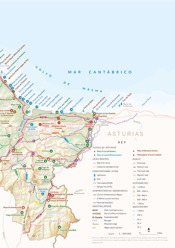
A Mariña Lucense comprises a swathe of northern Lugo that stretches across the Cantabrian coast, between Ribadeo and O Vicedo-O Barqueiro rias. Its boundaries are defined by the River Eo in the east, by the River Sor in the west and by O Xistral, Pousadoiro and Lourenzá mountain ranges on the southern, interior boundary.
Each of its sixteen boroughs is attractive in its own right: Alfoz, Barreiros, Burela, Cervo, Foz, Lourenzá, Mondoñedo, Ourol, A Pontenova, Ribadeo, Riotorto, Trabada, O Valadouro, O Vicedo, Viveiro and Xove, spanning an area of 1462 km2, and bound by physical, human and economic ties, with a clearly defined coexistence between coast and interior. The region can be divided up into three main areas: A Mariña Occidental, A Mariña Central and A Mariña Oriental.
CLIMATE:
The influence of the coast creates a mild climate, with no great variations in temperature, making it an ideal place to visit all year round. For its part, the sea is the warmest in the whole of Galicia, averaging 20º C in summer.
HOW TO GET THERE:
To reach your destination, the nearest airports are Santiago-Rosalía de Castro, A Coruña and Asturias.
By road, the A-8 motorway and, running parallel, the N-634 road, A Mariña Central and Oriental directly to the rest of Green Spain in the north, while the southern area is linked to the central plateau and the Atlantic axis via the A-6 motorway. In the west, the LU-540 also provides access, as it links the A-8 via the AG-64 (Vilalba-Ferrol).
In order to move around within the region, the N-634 in the east and the N-642 and LU-862 in the west both link up the coastal cities. Visitors can also take the picturesque FEVE narrow- gauge railway from Ferrol to Gijón. Inland, a network of primary and secondary roads link the towns there among themselves and to the coast, making it easier to see all of the destination’s resources.
TOURIST INFORMATION:
A Mariña Lucense has a virtual tourist information space in the CENIMA buiding (Paseo da Ribeira, 1) and tourism management comes under the authority of the Mancomunidade de Municipios da Mariña Lucense, owner of the amarinalucense.gal website.
At borough level, below is a list of the official websites of all of the boroughs, or specific tourism websites, with interesting information on each borough.
Some of the town councils have Tourist Information Offices that are open all year round, while others might only open in the spring and summer seasons (normally between Easter and the end of summer). In the case of the seasonal offices, tourist information services are provided by a department in the Town Council offices, in the same way as occurs in the boroughs which have no separate tourist office.
Alfoz
Capital: A Seara - Population: 1585 inhabitants
Tourist office permanent. Castelo de Castro de Ouro, s/n. 27776. Alfoz. 982 558 578 - turismo@concellodealfoz.com
Barreiros
Capital: San Cosme de Barreiros - Population: 3020 inhabitants
Tourist office seasonal. Currently open to the public at Rúa Veiga, s/n. 27790. San Cosme. 982 124 002 - turismo@concellodebarreiros.gal
Burela
Capital: Burela - Population: 9430 inhabitants
Tourist office seasonal. Rúa do Porto, s/n. 27880. Burela.
982 888 506 / 982 58 60 00 - oficinadeturismo@burela.org
Cervo
Capital: Cervo - Population: 4192 inhabitants
Tourist office seasonal. Avenida da Mariña, 60. 27890. San Cibrao.
982 595 157- turismo@concellodecervo.com
Foz
Capital: Foz - Population: 10,118 inhabitants
Tourist office permanent. Av. da Ribeira, s/n. 27780. Foz.
982 132 426 - turismo@concellodefoz.es
Lourenzá
Capital: Vilanova de Lourenzá - Population: 2115 inhabitants
Tourist office permanent. Centro de Interpretación da Faba. 27760. Vilanova de Lourenzá. 982 121 006 - lourenzaturismo@outlook.es
Mondoñedo
Capital: Mondoñedo - Population: 3.503 inhabitants
Tourist office permanent. Praza da Catedral, s/n. 27740. Mondoñedo.
982 507 177 - turismo@concellomondonedo.es
Ourol
Capital: Ourol - Population: 999 inhabitants
982 559 109
A Pontenova
Capital: A Pontenova - Population: 2191 inhabitants
Tourist office permanent. Est. a Taramundi, 2. 27720. A Pontenova. 982 342 101 - turismo@concellodapontenova.org
Ribadeo
Capital: Ribadeo - Population: 9811 inhabitants
Tourist office permanent. R/ Dionisio Gamallo Fierros, 7. 27700. Ribadeo. 982 128 689 - turismo@ribadeo.org
Riotorto
Capital: As Rodrigas - Population: 1187 inhabitants
Information at: 982 346 222 (Riotorto Town Council)
Trabada
Capital: Trabada - Population: 1107 inhabitants
Tourist office. R/ Celso Currás López, 14-16. 27765. Trabada. 982 143 956 - oficinaturismo@trabada.gal - 982 143 956 (Trabada Town Council)
O Valadouro
Capital: Ferreira do Valadouro - Population: 1938 inhabitants
Tourist office seasonal. Avenida Deputación, 6 (Casa da Cultura). 27770 . Ferreira do Valadouro.
Information at: 982 571 516 (ext. 3) - turismo@valadouro.gal
O Vicedo
Capital: O Vicedo - Population: 1665 inhabitants
Tourist office seasonal. Travesía da Mariña, 57. 27860. O Vicedo.
Information at: 982 590 195 / 982 590 029 - turismovicedo@gmail.com
Viveiro
Capital: Viveiro - Population: 15,231 inhabitants
Tourist office permanent. Av. Ramón Canosa, 3. 27869. Viveiro. 982 560 879 - oficinaturismo@viveiro.es
Xove Capital: Xove - Population: 3352 inhabitants
Tourist office seasonal. Av. Deputación, s/n. 27870. Xove. 982 592 632 - 982 592 001 - oficinaturismoxove@gmail.com
The data on population correspond to the official population figures resulting from the revision of the municipal population census as of 1 January 2022, provided by the National Statistics Institute.


