From Open Streets to High Walls: A comparative study of contrasting crime prevention approaches
From Open Streets to High Walls:
A Comparative Study of Contrasting Crime Prevention Approaches as seen in London Estate Complexes
Can an Urban Environments apply both CPTED and Defensible Spaces Strategies to design safer spaces?
Alessandro Meroni - C1915555
Dissertation 24/25 - AR5002
Cardiff University - Welsh School of Architecture YEAR 5
Dissertation Submitted in partial fullfilment of the degree of March 2023-2024
AWELSH SCHOOL OF ARCHITECTURE
AR5002_CANDIDATE’S STATEMENT & ACADEMIC INTEGRITY DECLARATION (as required by regulation)
You are required to complete this form and submit it with your work
I Alessandro Meroni, here declare that:
This work is entirely my own and expresses my own understanding except where clearly indicated.
I have clearly indicated any phrases and sentences that are not my own and referenced these.
I have not copied in part or whole or otherwise plagiarised the work of others.
I have acknowledged all the sources I used in preparation of this work including books, articles, reports, lecture notes and other forms of media.
I have fully and meticulously acknowledged that part of my dissertation that have been developed and submitted in the frame of the AR4402 Research Preparation assignments, or any version of them, at Cardiff University.
I declare that this work is entirely my own and no part of it has been produced by Generative AI tools.
1. I confirm that, except as stated below, my AR5002 dissertation is the result of my independent work.
Signed: Alessandro Meroni
Name: Alessandro Meroni
Date: 18/12/2024
2. I hereby give consent for my dissertation, if accepted, to be available for photocopying and for inter-library loan, and for the title and summary to be made available to outside organisations.
Signed: Alessandro Meroni
Name: Alessandro Meroni
Date: 18/12/2024
N.B. You are required to indicate below any portion of the work for which you are indebted to others.
3. I hereby give consent for my MA rch Dissertation manuscript and/or 3minutes video to be made available to future students via Learning Central and/or Teams, and used if needed in material produced by Cardiff University for accreditation purposes
Agree
Signed: Alessandro Meroni
Name: Alessandro Meroni
Date: 18/12/2024
Abstract
This dissertation aims to determine the effectiveness of place-based crime prevention theories, focusing predominantly on the extent to which public enhancing strategies (rooted in New Urbanism) versus public mitigating strategies (rooted in Fortress Mentality) contribute to differences in the presence of crime. The study evaluates these theories through a comparative analysis of their principles and their practical application in urban estate complexes in London.
By isolating the principles of CPTED and Defensible Spaces, the research is able to focus on the contradictory nature of these two theories so it can address their combined use in the UK planning Guidance Safer Places. The collected findings suggest that combining CPTED and Defensible Spaces within the same estate is common practice in real world application. However, its effects on crime rates vary depending which School of thought is more prevalent. A primarily New Urbanist estate design supported by Defensible Spaces strategies appears to be more successful than the opposite scenario. Secondly the data suggests a surprising by-product of well designed gathering spaces (whether from a CPTED approach or Defensible Spaces approach). These appear to negatively affect crime rates in nearby areas by enhancing lack of natural surveillance in them. People prefer the gathering space rather than the less exciting adjacent area; creating a sense of isolation.
The research was completed through a mixed research design applying Multiple Case Study analysis and correlational research involving both quantitative and qualitative data. Two estates within Greenwich (Kidbrooke Village, Millennium Village) represented average London crime rates while minimising uncontrolled variables between them. Through a desktop study the two estates were assessed for both the presence of crime and the application of crime-prevention strategies in their built environment. The outcome of which is visualised through crime hotspot maps, crimeprevention strategies maps and sketches of the built environment. The data was subsequently used for a comparative analysis between the two cases with the goal of highlighting any common patterns; with a focus on the following principles: Territoriality, Target Hardening, Mixed Use, Access Control and Gathering Spaces.
The discussion supports the need to produce more evidence for the success of crime-prevention theories; however, it highlights the need to change how research is conducted within this field. Moreover, it highlights how it is common for both theories to coexist in real world development and the Government publication approach might therefore be more useful to designers.
Contents
Research Proposal
Background
Scope & Aim
Research Objectives
Literature Review
Establishing Dominant Theories and Schools of Thought
Application of Theory in Contemporary Urban Planning
Past Research Design Assessing the Success of Theory
Comprehensive Comparison of Theory
Comparison of Public Enhancing/ Mitigating Strategies
Methodology
Research Philosophy
Research Design
Sampling Strategy: Selecting Cases
Controlled Variables
Dependent Variables
Defining- Bounding the Cases
Data Collection Method
Data Analysis Methods
Results
Crime Glossary
Kidbrooke Village & Sutcliffe Area Profile
Kidbrooke Village Crime Hotspots
Kidbrooke Village Crime-Prevention Strategies
Table of Crime-Prevention Strategies
Sketches of Key Areas
Greenwich Peninsula Area Profile
Millennium Village Crime Hotspots Map
Millennium Village Crime-Prevention Strategies Map
Employed Crime Prevention Strategies
Sketches of Key Areas
Discussion
A Mixed Approach to Crime Prevention
New Urbanism into Fortress Mentality
A By-Product of Gathering Spaces
Imitations of Study
Practical Application of Findings
Future Research
Conclusion
Figures List
Figure 1: CPTED parentage (Meroni, 2024)
Figure 2: CPTED strategies impacting public permeability into well-defined urban environments (Meroni, 2024)
Figure 6: Similarities between the principles of CPTED, Defensible Spaces and Safer Places (Meroni, 2024)
Figure 7: Differences between the principles of CPTED, Defensible Spaces and Safer Places (Meroni, 2024)
Figure 8: Comparison of CPTED and Defensible Spaces crime-prevention strategies as observed in the built environment. The five principles outlines have a direct impact to public life as highlighted by the literature review. (Meroni, 2024)
Figure 9: Age range of Kidbrooke Village & Sutcliffe - data from Office of National Statistics (Meroni, 2024)
Figure 10: Age range of Greenwich Peninsula - data from Office of National Statistics (Meroni, 2024)
Figure 11: Gender Ratio of Kidbrooke Village & Sutcliffe - data from Office of National Statistics (Meroni, 2024)
Figure 12: Gender Ratio of Greenwich Peninsula - data from Office of National Statistics (Meroni, 2024)
Figure 13: Economic activity of Kidbrooke Village & Sutcliffe (Meroni, 2024)
Figure 14: Economic activity of Greenwich Peninsula (Meroni, 2024)
Figure 15: Education Level of Kidbrooke Village & Sutcliffe (Meroni, 2024)
Figure 16: Education Level of Greenwich Peninsula (Meroni, 2024)
Figure 17: Household Deprivation of Kidbrooke Village & Sutcliffe (Meroni, 2024)
Figure 18: Household Deprivation of Greenwich Peninsula (Meroni, 2024)
Figure 19: Ethnicity of Kidbrooke Village & Sutcliffe (Meroni, 2024)
Figure 20: Ethnicity of Greenwich Peninsula (Meroni, 2024)
Figure 21: Religion in Kidbrooke Village & Sutcliffe (Meroni, 2024)
Figure 22: Religion in Greenwich Peninsula (Meroni, 2024)
Figure 23: Location of Kidbrooke Village & Sutcliffe (Meroni, 2024)
Figure 24: Kidbrooke Village Crime Hotspots Map (Meroni, 2024)
Figure 25: Kidbrooke Village Crime-Prevention Map (Meroni, 2024)
Figure 26: Predominant School of thought in Kidbrooke Village (Meroni, 2024)
Figure 27: Predominant Crime-Prevention Principles in Kidbrooke Village (Meroni, 2024)
Figure 28: Comparison of CPTED and Defensible Spaces crime-prevention strategies as observed in the built environment - Strategies employed in Kidbrooke Village highlighted in orange (Meroni, 2024)
Figure 29: Kidbrooke Village Map showing location of sketches (Meroni, 2024)
Figure 30: Mixed use of the central Square (Meroni, 2024)
Figure 31: Gathering space seating under natural surveillance (Meroni, 2024)
Figure 32: Kidbrooke Village Map showing location of sketches 2 (Meroni, 2024)
Figure 33: Back side of Southeastern train station (Meroni, 2024)
Figure 34: Change in paving texture (Meroni, 2024)
Figure 35: Kidbrooke Village Map showing location of sketches 3 (Meroni, 2024)
Figure 36: Example of planting vase with estate branding (Meroni, 2024)
Figure 37: Location of Greenwich Peninsula (Meroni, 2024)
Figure 38: Millennium Village Crime Hotspots Map (Meroni, 2024)
Figure 39: Millennium Village Crime-Prevention Map (Meroni, 2024)
Figure 40: Predominant School of thought in Millennium Village (Meroni, 2024)
Figure 41: Predominant Crime-Prevention Principles in Millennium Village (Meroni, 2024)
Figure 42: Comparison of CPTED and Defensible Spaces crime-prevention strategies as observed in the built environment - Strategies employed in Millennium Village highlighted in orange (Meroni, 2024)
Figure 43: Millennium Village Map showing location of sketches (Meroni, 2024)
Figure 44: Main public square (Meroni, 2024)
Figure 45: Vehicle gate as shown by the North West entrance (Meroni, 2024)
Figure 46: Millennium Village Map showing location of sketches 2 (Meroni, 2024)
Figure 47: Car Park to the North East (Meroni, 2024)
Figure 49: Millennium Village Map showing location of sketches 3
Figure 50: Example of paths throughout the estate
Research Proposal
Background
The dissertation covers the rise of place-based crime prevention from historical significance to the influence predominant theories have had on the latest UK planning guidelines; aiming at establishing a trend between hotspots for crime in an estate and the surrounding crime-prevention strategies in its immediate context.
The paper identifies two different schools of thought (Kitchen 2005): New Urbanist ideologies and Fortress Mentality; under which the theories Crime Prevention Through Environmental Design (CPTED) and Defensible Spaces: Crime Prevention Through Urban Design (Defensible Spaces) (Newman 1973; Schneider 2005) can be categorised depending on how they view the presence of the public within a residential urban environment.
The government publication: Safer Spaces, is critiqued for taking parentage from these two theories which belong to different schools of thought. Although the theories are relatively similar, they have contrasting opinions on whether encouraging public life within an otherwise private residential environment is a positive or negative factor regarding crime rates. However, the publication was forced to not take an explicit stance on this issue due to the overall lack of empirical evidence proving which crime prevention theories and strategies work. This lack in evidence might be partly in cause of research frameworks that have been conducted on the topic thus far. Wherein the required methodological approach is of a longitudinal quality which takes extensive time before showing any data indicative of a change in crime rates. Moreover, studies tend to assess the success of a theory in its entirety; however, the crime prevention theories analysed in this paper are composed of upwards of 7 principles each (sometimes referred to as strategies or attributes). Therefore, while a study might suggest a theory is successful at lowering crime there is little indication to which of the contained principles are responsible for the improvement.
Research Proposal
Scope & Aim Research Objectives
The study will determine the effectiveness of place-based crime prevention theories focusing on the extent to which the application of public reducing/ enhancing strategies might contribute to a direct difference in the presence of crime. These crime mitigating qualities will be measured within London based estate complexes afflicted by average crime rates per borough.
By implementing this aim, the study hopes to assess CPTED and Defensible Spaces in terms of effectiveness through comparison by focusing only on principles within the two theories which contradict each other. So doing, the effectiveness of New Urbanist public enhancing strategies VS Fortress Mentality public mitigating strategies can be assessed isolated from the remaining principles.
Lastly, rather than selecting a cases according to its documented application of a crime prevention theory in its design decisions (as has often been the case with past research); The study will select cases based primarily on reported crime rates and demographics. Therefore, the presence of crime prevention strategies from either CPTED or Defensible Spaces within the architecture of the cases will be purely coincidental. Thus, marginalising bias towards any one theory.
The academic discourse will start with a reflection on Jane Jacobs’ work, specifically The Death and Life of Great American Cities (Jacobs 1961). This will present a clear contextual catalyst to the surging of place-based crime prevention theories.
Moreover, it will highlight the rise of New Urbanism as a global shift in the approach to urban design where interconnected communities and enhanced public life became sought after. Within this urban enhancing approach, the crime prevention theory: Crime Prevention Through Urban Design (CPTED) by C. Ray Jeffrey (Schneider 2005) will be established. Its forming principles discussed, and its New Urbanist parentage highlighted.
Having established a historical and ideological context the first theory, Defensible Spaces: Crime Prevention Through Urban Design by Oscar Newman (Newman 1973) will follow. Discussing its contrasting approach of separating public and private life highlighted through the Fortress Mentality school of thought.
Finally, the literature review will discuss the use of crime prevention theories in today’s cityscape through an analysis of Safer Spaces: The Planning System and Crime Prevention, published by the UK government in 2014. As well as the need to establish a different research design to study the success of these theories at lowering crime rates.
1. Establish how New Urbanism and Fortress Mentality view the presence of public life in an urban environment. Accordingly, define CPTED AND Defensible Spaces as taking parentage from either school of thought.
2. Compare and contrast the individual principles from CPTED and Defensible Spaces to establish strategies directly affecting public life in a private residential environment. So that these may be studied in isolation to the other principles.
3. Highlight the presence of both CPTED and Defensible Spaces as framework for the planning guidance Safer Places; therefore, establish its approach to the dilemma of public life.
4. Explore prevailing issues of past research studying the success of crime prevention theories to suggest a reason for the lack of imperial evidence in this field.
5. Develop a comprehensive table depicting the built form crime prevention strategies take, to inform case study research and data collection in the following chapters.
Establishing Dominant Theories and Schools of Thought
The rise of an urbanisation movement in the 1950s drove people from the countryside into cities which, ill-equipped to sustain their largely growing population, quickly became overcrowded (Meroni 2023). As a byproduct the increased population brought with it an increase in crime rates; planners were preoccupied with housing this large influx of residents more so than designing healthy landscapes (Meroni 2023). “Increased specialization and rationalization mitigated the concern for public space and public life. No one was charged with responsibility for life between buildings, and traditional know-how about the interaction of urban life and space was lost during this rapid [...urbanisation]” (Gehl and Svarre 2013). As a result, academics started to question whether the design of cities was itself part of the problem.
The most influential piece of work which emphasised these city-wide issues is The Death and Life of Great American Cities (1961) by Jane Jacobs. This book leads the reader through observational research and anecdotal stories to define 3 principles necessary for creating safe urban environments: diversity, density and community interactions. All principles which according to Jacobs are irremediably tied to the role and function of the sidewalk (Jacobs 1961). Thus, Jacobs became a catalyst inspiring many
urban design theories, some of which are heavily discussed in this paper: New Urbanism, Crime Prevention Through Environmental Design (CPTED) and Defensible Space: Crime Prevention Through Urban Design (Defensible Spaces) all mention Jane Jacobs and her work (Schneider 2005).
New Urbanism and CPTED
New Urbanism is a strategic urban planning practice which emerged in the late 20th century. Given its predecessor Jacobs (Kitchen 2005), the theory shares an aspiration for creating traditional urban living dynamics which promote the positive characteristics of community cohesion. Its overarching aim can be described as an “Attempt to balance individual choice with public responsibilities.” by designing “landscapes where a more public-spirited life is at least possible.” (Ellis 2002) So doing, this practice offers alternatives to the dominant low density urban patterns which encourage auto dependent land use. Its principles are paraphrased as such (Congress for the New Urbanism 2024):
According to New Urbanism, the public is inherently good and should be included within the design of urban spaces. “Well-designed streets and public spaces provide a supportive environment for place-based socializing for residents who [...] wish to pursue a more spatially expansive social life [...]. There are no gates or walls.” (Ellis 2002). The similarities between Jane Jacobs and New Urbanism are very clear in their support for increased community cohesion as quintessential for a both healthy and safe cities.
1. Design identifiable centres and perimeters to cities, towns and neighbourhoods
2. Encourage Sustainable high-density development that preserves farmlands
3. Prioritize Infill development that revitalises city centres
4. Create streets interconnected with each other
5. Encourage pedestrianisation and cycling
6. Encourage mixed use environments
7. Avoid auto-dominated landscapes
8. Support Transit-oriented development
9. Include well-designed public gathering spaces/ civic buildings
10. Create coherent urban form
11. Conserve green space as connections between neighbourhoods
12. Development respects regional character and history
New Urbanism & CPTED
Following suite, the first place-based crime prevention theory to gain global traction was published in 1971 by C. Ray Jeffrey: Crime Prevention Through Environmental Design (CPTED) (Schneider 2005). This theory is shown to take deep parentage from Jane Jacobs’ work, however, more importantly its principles demonstrate association within a New Urbanist school of thought. Jeffrey rejected the notion that incarceration is an effective response to crime; suggesting that preventative measures would be better deterrents. Simply put: “The proper design of the built environment can lead to a reduction in the fear of crime and the incidence of crime” (Schneider 2005). Its guiding principles are as follow (Schneider 2005):
5 out of these 8 principles are explicitly connected with a New Urbanist principle − Refer to figure 6 and 7 at the end of the literature review for a comprehensive comparison between the principles of all the theories analysed in this chapter. This is particularly interesting since New Urbanism doesn’t specifically reference safety measures in any of their principles; however, these are argued to be quite crucial to the successful implementation of its ideologies so long as they don’t interfere with the freedom of the public.
“The revitalization of urban places depends on safety and security. The design of the streets and building should reinforce sage environments, but not at the expense of accessibility and openness” (Kitchen 2005).
1. Maximise natural surveillance from people
2. Control foot fall through access routes
3. Defined private vs public spaces
4. Resolve conflicting uses/ activities
5. Design transitional zones between public and private spaces
6. Design thoughtful gathering spaces
7. Encourage constant activity on site
8. Reduce anonymous and isolated spaces
Out of these 8 principles numbers 5, 6, 7 and 8 have a direct impact towards public permeability into a well-defined urban environment; therefore, the research will only focus on these CPTED strategies moving forward (figure 2).
1. Design transitional zones between public and private spaces
2. Design thoughtful gathering spaces
3. Encourage constant activity on site
4. Reduce anonymous and isolated spaces
2: CPTED strategies impacting public permeability into well-defined urban environments (Meroni, 2024)
Figure 1: CPTED parentage (Meroni, 2024)
Figure
Fortress Mentality & Defensible Spaces
On the other side of the coin lies Fortress Mentality; the “gates or walls” (Ellis 2002) approach. While this school of thought does not strictly refer to the field of urban design or architecture, its presence in these practices is notable. It characterises the fear of any external insecurities, threats or scarcities (be it economic, political or environmental); which causes a response factor involving the creation of protective barriers (symbolic or literal) to safeguard a collective interest (Low 2001). This may happen at an individual scale through personal dwelling fortifications, as well as nation-wide defences such as strict immigration laws (Low 2001). Hence the name Fortress Mentality, as it mimics the principle of erecting walls around a mediaeval town to protect its habitants from invaders.
Beyond this general attitude, no specific principles are outlined through which this ideology defines its values. However, a common, although somewhat superficial, example of fortress mentality in urban design is the prior mentioned adoption of fences around complexes. This suggest a very crucial distinction between New Urbanism and Fortress Mentality. The latter’s attitude is one of distrust for strangers, and therefore willingness to isolate themselves from the public. An approach deeply frowned upon by New Urbanism as according to its ideology it will only increase discrimination and
general fear to strangers and outsiders. “The rest of the city is left to die while the fenced haven persists untouched” (Jacobs 1961).
The second highly referenced place-based crime prevention theory was published in 1972 by Oscar Newman: Defensible Spaces: Crime Prevention Through Urban Design (Defensible Spaces) (Piroozfar et al. 2019). Although Newman makes references to Jane Jacobs and CPTED, and some academics even suggest his theory is a further development from “2nd generation CPTED” (Piroozfar et al. 2019); there is a clear distinction in his work which emphasises strategies through a Fortress Mentality approach rather than a New Urbanist one. The overall aim of Defensible Spaces can be ascribed as encouraging the use of design to enhance territoriality and create a sense of ownership through clearly differentiated private and public spaces; or as Newman describes it: “a social fabric that defends itself”. The Fortress Mentality school of thought is evident. While Newman does, to some extent, promote community cohesion by suggesting it can decrease crime; the extent of it is very minimal compared to New Urbanism. Furthermore, rather than increasing community interactions on a neighbourhood or even wider scale, it promotes community purely on a residential complex level. Executed so the
residents can assume territorial attitudes towards their shared environment. “Defensible space is a surrogate term for the range of mechanisms [...] that combine to bring an environment under control of its residents.” (Newman 1973). The range of mechanisms are as follow (Piroozfar et al. 2019):
1. Nurturing territorial attitudes of residents towards their environment
2. Maximise surveillance (both natural and artificial)
3. Minimise access routes
4. Distinguish private space from public space
5. Activity Support
6. Reduce fear towards environments separated from the public
7. Adopt fences, gates and other means to fortify an environment
Given parentage from CPTED and Jane Jacobs, the two crime prevention theories do share principles in common. However, this paper will focus specifically on the principles which contradict each other. These are where the more prevalent differences in New Urbanism vs Fortress Mentality are apparent. Not surprisingly these are also the principles which contradict each other on matters of public permeability. For Defensible Spaces the focus will be on principles 1, 3, 4 and 7
Nurturing territorial attitudes of residents towards their environment
Minimise access routes 3. Distinguish private space from public space 4. Adopt fences, gates and other means to fortify an environment
Figure 4: Defensible Spaces strategies impacting public permeability into well-defined urban environments (Meroni, 2024)
Application of Theory in Contemporary Urban Planning
New Urbanist Sustainable Communities
Since their initial conception in the early 70s, place-based crime prevention theories have gained traction in urban design practices. Moreover, the imposition of a new duty in Section 17 of the Crime and Disorder Act 1998 (Crime and Disorder Act 1998) declared UK planning authorities must, at the best of their abilities, prevent crime and disorder (Kitchen 2005). Hence in 2004 the British government published Safer Places: The Planning System and Crime Prevention (Safer Places) (Llewelyn Davies 2004). In hopes to encourage planners and developers to address crime prevention strategies during the design process as they are cheaper and more successful to implement in concept creation than as a retrofit addition.
Therefore, the purpose of the publication is to “help deliver [...] well-designed, sustainable places that do not fail people and stand the test of time” (Llewelyn Davies 2004) by demonstrating “how good planning can contribute to crime prevention and the creation of safer places and hence to welldesigned, sustainable communities.”(Davies 2004). Additionally, in the introductory chapter it explicitly states the publication is “evidence-based” (Davies 2004) even though this might “not always be clear” (Davies 2004) and can potentially be contradictory between what is best for crime prevention and what is best for sustainable development.
Before outlining strategies that can be employed to lower crime opportunity, the publication begins by defining the principles for the above mentioned “sustainable communities” (Davies 2004). These principles are all largely rooted within a New Urbanist school of thought suggesting concepts such as: flourishing local economies; healthy environments with well-designed public/ green spaces; good public transport infrastructure and a “sense of place” (Davies 2004). Ultimately, its 10th principle is very telling of the overall New Urbanist approach: “A diverse, vibrant and creative local culture, encouraging pride in the community and cohesion within it” (Davies 2004).
This extensive list of principles placed at the start of the publication would imply the place-based crime prevention strategies that follow will be largely inspired by CPTED or other such New Urbanist crime prevention theories. However, this is not strictly the case. Both CPTED and Defensible Spaces are explicitly named within the publication as parents (among other listed theories) to the publication. Additionally, the UK’s own police force Fortress Mentality practise: Secured by Design (SBD) is deeply embedded within the publication; appearing 45 times in the document
New Urbanist & Fortress Mentality Principles
Safer Places is subdivided into 7 chapters discussing various crime prevention strategies within them. These chapters serve a similar purpose as the principles explored thus far in CPTED and Defensible Spaces: outlining the main principles of the publication.
1. Access and movement: “places with welldefined routes, spaces and entrances that provide for convenient movement without compromising security” (Davies 2004)
2. Structure: “places that are structured so that different uses do not cause conflict” (Davies 2004)
3. Surveillance: “places where all publicly accessible spaces are overlooked” (Davies 2004)
4. Ownership: “places that promote a sense of ownership, respect, territorial responsibility and community” (Davies 2004)
5. Physical Protection: “places that include necessary, well-designed security features” (Davies 2004)
6. Activity: “places where the level of human activity is appropriate to the location and creates a reduced risk of crime and sense of safety at all times” (Davies 2004)
7. Management and Maintenance: “places that are designed with management and maintenance in mind, to discourage crime in the present and the future” (Davies 2004)
Within these principles the recommended strategies vary to a high degree between New Urbanist approaches and Fortress Mentality. Under the Structure principle it states “A safe urban structure has few sides of the building exposed to the public realm” (Davies 2004); while suggesting that “vulnerable” (Davies 2004) public space should be removed from the public realm and be converted into private use exclusively for the residents of the structure (Davies 2004). A response akin to that of Fortress Mentality. It continues by suggesting how these private residential spaces might be identified under the principal Ownership, stating it is necessary to provide “clarity in where public space ends and where communal, semi-private or private space begins” (Davies 2004). Which can be achieved through physical barriers such as “gates” and “fences” (Davies 2004): once again implying a Fortress Mentality approach.
However, within the same chapter the publication clarifies that “it is normally preferable for new development to be integrated into the wider community” (Davies 2004); suddenly suggesting a strategy which is New Urbanist leaning and almost contradictory to its previous highlighted strategies. Additionally, just two chapters below, under Activity it states how successful design will create high quality environments with multiple uses that will attract a “large number of people” (Davies 2004) which aren’t part of the immediate community. Once again arguing in favour of New Urbanism. This latter point is implied by the necessity of these areas to be coordinated with public transport so that “users [...can] leave for home as soon as they are ready.” (Davies 2004) suggesting the large number of people aren’t residents of the community.
Due to these contradictions within the publication, its effectiveness is up to debate. It is no surprise this recommendation has sparked controversy amongst academics; A few of which have extensively criticised its applicability as a planning guidance (Kitchen 2005). The publication has overall been labelled indecisive given the mixed approach of two completely opposing schools of thought (Kitchen 2005). Ted Kitchen argues that this publication is a result of a general overarching
lack of strong, quantitative and empirical evidence as to what crime prevention theories work and why. Consequently, the British planning guidance (Safer Places) opted to simply reach a middle ground wherever there was indecisiveness; however, this neither fully resolves any conflicting ideologies, nor allows either theory to properly reach its full potential (Piroozfar et al. 2019).
On the other hand, it is important to note that regardless of the effectiveness of the publication, no crime prevention strategy will always be worse than some form of crime prevention, however unclear it may be. Therefore, the document should not be chastised for attempting to make the best use of the information at hand. Especially when considering the lack of evidence is twofold: there is little indication which theory is more successful than the others, but also little research has been conducted on whether a mix of theories is in fact the best option. As put by Richard H. Schneider, “the strategies ought to be included on the menu of choice that designers, planners [...] and policy makers have to choose from” (Schneider 2005) regardless of a lack thereof evidence.
Past Research Design Assessing the Success of Theory
Vague Terminology Used to Describe Theory
Inadequate Application of Theory
As the “Application of Theory in Contemporary Urban Planning” chapter started to discuss, there is an overall lack of empirical data stipulating the success of crime prevention theories. This is a field wide issue afflicting all place-based crime prevention theories as well as their overarching schools of thought. This, to a certain extent, can be broken down into 3 general problems often encountered in trying to procure this evidence.
(1) Vague terminology used to describe theories;
(2) Inadequate application of theory;
(3) Longitudinal requirements of research.
This chapter will analyse these problems to help develop a different approach in the methodological section of this paper.
In her appropriately titled article Crime Prevention
Through Environmental Design (CPTED): Yes, No, Maybe, Unknowable, and All of the Above; Taylor suggests that the representative success of these theories largely depends on “how you define key terms, how rigorous is the proof you demand, and how complete an answer you seek” (Taylor 2002).
A factor which is often overlooked.
All the theories discussed in this paper contain several principles; these principles aren’t always self-explanatory. For instance, both CPTED and Defensible Spaces mention the concept of territoriality; for the latter it is a crucial element which stipulates the overall theory. However, it is hard to precisely define and identify the concept of territoriality, making it hard to measure and therefore determine the success of the principle.
“Defensible space was thought to be too narrow and territoriality too difficult to assess in certain spaces of land uses [...] to be evaluated.” (Schneider 2005). Therefore, a definition of every key principle studied in this paper will be provided via a set of real-world examples. This information can be found in a comprehensive table produced as outcome of the literature review (figure 8)
The present lack of evidence is also a by-product of a systematic gap in theoretical frameworks and real-life application. It is already a significant task identifying case studies where there is documented evidence that the application of a place-based crime prevention theory was utilised to inform design decisions.
To contextualise it, the British planning publication Safer Places was only released in 2004 (Davies 2004), before which it is not a assumed that developers were aware and actively designing with any theoretical approach to crime prevention. On the other hand, not all built cases that appear to follow a theory are viable options for research;.
In some cases, the outlined crime prevention principles aren’t always executed correctly so that analysis of their success is “inadequate in advancing the state of knowledge” (Schneider 2005).
Longitudinal Requirements of Research
Lastly, in order to collect truly empirical quantitative evidence three conditions must apply, all resulting in an extensive longitudinal study:
1. There must be an existing case study with a long history of crime problems and the necessary substantial amounts of crime data associated with it. This ensures that a robust enough
baseline crime rate can be established to which later findings can be compared against.
2. The case study must undergo a retrofit or redevelopment where the theoretical framework of a place-based crime prevention theory and its principles are adequately and correctly applied. Thus, avoiding a case fallacy as described in ‘Inadequate Application of Theory’.
3. Enough time must pass post redevelopment to ensure the change in crime rates is factually representative of the intervention. When considering more intangible strategies that consist in creating community cohesion, the time necessary to truly instil this ‘sense of belonging’ is both quite extensive and hard to determine.
To truly emphasise how these necessary criteria have been a significant hold back in research, there have only been extremely few cases where such a study was conducted in the UK. One example being Hulme, a redevelopment of an inner-city housing scheme in Manchester redesigned following New Urbanist principles. The data collection was conducted for 10 years, and the evidence is inconclusive (Kitchen 2005).
Comprehensive Comparison of Theories
Surveillance Access Routes Private vs Public Conflicting Activity Territoriality Target Hardening
Maximise natural surveillance from people
Maximise surveillance (both natural and artificial)
Design overlooked publicly accessible spaces
Safer Places CPTED
Control foot fall through access routes
Defensible Spaces
Surveillance Access Routes Private vs Public Conflicting Activity Territoriality Target Hardening
Maximise natural surveillance from people
Defined private vs public spaces Resolve conflicting uses/ activities
Control foot fall through access routes Defined private vs public spaces Resolve conflicting uses/ activities
Minimise access routes
Maximise surveillance (both natural and artificial)
Distinguish private space from public space
Minimise access routes Distinguish private space from public space Activity Support?
Activity Support?
Design overlooked publicly accessible spaces
Define routes, spaces and entrances to provide for convenient movement without compromising security
Structure environments to avoid different uses causing conflict
Define routes, spaces and entrances to provide for convenient movement without compromising security
Define routes, spaces and entrances to provide for convenient movement without compromising security
Structure environments to avoid different uses causing conflict
Nurturing territorial attitudes of residents towards their environment
Promote a sense of ownership, respect, territorial responsability and community
Define routes, spaces and entrances to provide for convenient movement without compromising security
Adopt fences, gates and other means to fortify an environment
Nurturing territorial attitudes of residents towards their environment
Include necessary, well’designed security features
Promote a sense of ownership, respect, territorial responsability and community
Thresholds Isolation Gathering Spaces
Thresholds Isolation Gathering Spaces
Design transitional zones between public and private space
Defensible Spaces
Safer Places CPTED
Design transitional zones between public and private space
Reduce anonymous and isolated spaces
Reduce fear towards environment separated from the public
Reduce anonymous and isolated spaces
Design thoughtful gathering spaces
Reduce fear towards environment separated from the public
Design thoughtful gathering spaces
Encourage managmnet and maintanance to discourage crime in future
Encourage constant activity on site
Adopt fences, gates and other means to fortify an environment
Include necessary, well’designed security features
Include an appropriate level of human activity to reduce risk of crime and improve sense of safety at all times
Mixed Use Managment Similarities Differences
Encourage constant activity on site
Include an appropriate level of human activity to reduce risk of crime and improve sense of safety at all times
Mixed Use Managment
6: Similarities between the principles of CPTED, Defensible Spaces and Safer Places (Meroni, 2024)
Information from the Table was compiled through extensive readings into the following sources: (Van Der Voordt and Van Wegen 1990; White 1990; Garland 1996; Newman 1996; Tilley and Sidebottom 2005; Armitage 2006)
Encourage managmnet and maintanance to discourage crime in future
7: Differences between the principles of CPTED, Defensible Spaces and Safer Places (Meroni, 2024)
Figure
Figure
Comprehensive Comparison of Contrasting Strategies
Territoriality
Discouraged N/A
Assign specific zones (front yards, backyards) to specific households
Integration of community-focused amenities/ areas for residents use only
Place entrances oriented toward public streets giving residents direct visibility over adjacent areas
The use of identifiable landmarks to encourage community pride
Incorporation of neighbourhood/ corporate branding
Installation of protective grilles, shutters, or bars on windows
Installation of barriers to control entry into private or restricted areas
Sharp-edged fencing/ spikes on walls
Differences
Designate mixed-use spaces that naturally attract a variety of people
Placement of public amenities in areas that benefit from oversight and promote continuous foot traffic
Integrate residential and commercial land uses
Use of physical boundaries to define private, semi-private, and public spaces
Visual markers to delineate: resident areas, parking, visitor zones, private property, restricted areas, and community watch presence
Design curving, well-lit paths that guide people through safe areas and limit access to secluded spots
Trim or avoid using large shrubs or hedges around entryways and paths
Positioning of buildings and pathways to allow for natural surveillance from homes and prevent secluded areas
Discouraged
Conversion of traditional public streets into semi-private or private spaces to limit unwanted traffic
Implementation of traffic-calming measures to discourage non-resident usage of residential areas
Creation of neighbourhood entry and exit points
Limiting the number of through-paths or access points to discourage easy movement across a property
Figure 8: Comparison of CPTED and Defensible Spaces crimeprevention strategies as observed in the built environment. The five principles outlines have a direct impact to public life as highlighted by the literature review. (Meroni, 2024)
Avoiding creating dense, enclosed areas that could conceal potential criminal activity
Maximise sight lines in public spaces to enhance the perceived presence of natural surveillance
Developments of parks and public spaces that are actively used and encourage social engagement
Ensure these areas are well frequented
Ensure the layout of parks or communal green spaces have inviting seating and gathering spots to foster positive activities
Internal courtyards sorrounded by residential blocks
Layout promotes territorial attitudes over gathering space
Non residents utilising the gathering space are easily spotted
Methodology
Research Philosophy
The study questions whether a relationship can be established between crime prevention principles linked to public permeability reducing/ enhancing methods and the presence of crime within London based estates. The data collected will therefore begin to build a case whether New Urbanist learning theories are more suitable for mitigating crime than a Fortress Mentality school of thought; or whether combining theories, as was the case with Safer Places, is perhaps more effective.
This chapter will begin by outlining the research philosophy framing this study as well as the research type. Once established it will delve into specific research design, sampling strategies, defining the cases and data collection/ analysis methods. Culminating in a mixed research approach where two London estate complexes are analysed through quantitative database research and a qualitative desktop study. Both producing a comprehensive plan depicting crime activity and crime-prevention strategies employed on site. Where relevant these latter will be highlighted through sketches of the built environment as secondary evidence of their application. Any identified limitations of the methodology will be stated after analysing the findings from the research in the discussion chapter.
Given the nature of the research aim and questions, the study is working with the use of quantitative data which can be objectively observed and measured. It aims to explain the socio-physical relationship between the built environment and the crime rates which inflict it. However, the study assumes a Post-positivist stance(Groat and Wang 2013) as it “presume that objectivity is a legitimate goal that may [only] be imperfectly realized” (Groat and Wang 2013). Additionally, the methodology employs a correlational strategy which may not necessarily strictly follow positivist notions.
Within this post-positivist philosophy, the research follows a deductive structure; wherein it assumes a top-down confirmatory approach. The outlined theoretical frameworks of CPTED and Defensible Spaces represent the starting point of the research, and their principles are directly assessed throughout the study to inform questions posed prior.
Research Design
The place-based crime prevention theories are intrinsically tied to their urban environment. Case study research is fundamental for any analysis to occur as this “Investigates a contemporary phenomenon (the “case”) in depth and within its real-world context” (Yin 2018). However, this study adopts a multiple-Case Study Design specifically following a literal replication framework. This consists of deliberately selecting cases operating within similar crime rates to determine the presence of patterns, if any, between the crime rates and public focused prevention strategies. The included cases are of an average level crime rate to be representative of the most common conditions.
The study also aims to “Clarify patterns of relationships between two or more variables [...] involved in [a particular setting or] circumstances under study” (Groat and Wang 2013). This implies the adoption of correlational research design where the measured variables in question are the presence of crime vs the presence of public restricting/ enhancing crime prevention strategies in London based estate complexes. This research design is exceptionally suitable for this thesis given, the relationship under study is strictly contextual and more importantly, the variables cannot be manipulated from their real-life context to assess any hypotheses.
Therefore, the research design assumes the form of a mixed research in which a Multiplecase study (Yin 2018) adopts the role of the dominant design within which aspects of correlational research (the less-dominant design) are strategically implemented. Such a study increases the overall validity of the paper as each research method “provides appropriate checks against the weak points [... of the other method], while simultaneously enabling the benefits to complement each other” (Groat and Wang 2013). It is important to note a weakness of dominant less-dominant design is how the full advantages of the less-dominant design (correlational research) might not always be fully realised.
The sampling strategy that identifies suitable cases follows a non-probability approach where the cases are selected according to specific conditions (Yin 2018). The studied estate complexes retain as many controlled variables between them as possible. These ensure any results extrapolated from the study are not affected by external variables with the exception of the ones being observed. Therefore, when the results are compared against each case, there is a higher degree of certainty that the crime levels are a result of the place-based Crime Prevention strategies. Where necessary data collection used to quantify the variables is collected using publicly accessible databases.
The thesis does not separate itself entirely from past research methodologies used to study the subject. Place-based crime prevention is highly studied in the context of estate complexes. Oscar Newman’s research which led him to publish Defensible Spaces was entirely conducted on this typology (Newman 1973). Since one of the goals of this paper is to evaluate a different approach at assessing these theories, it remains in the familiar architecture of estates. Additionally, these typologies often involve multiple buildings causing the creation of internal courtyards and pseudo public spaces; both of which are essential when comparing New Urbanism and Fortress Mentality.
Location
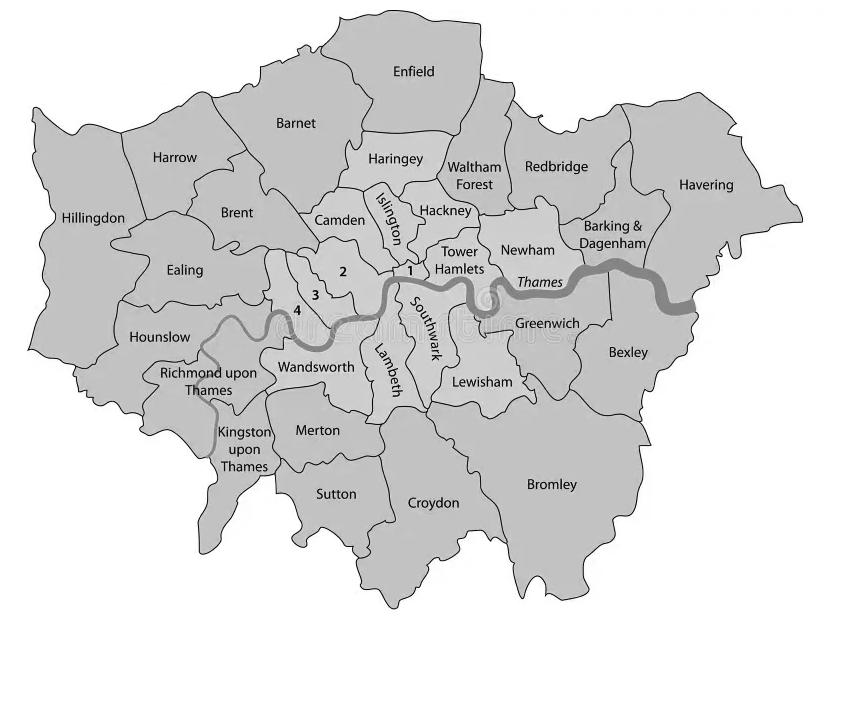
This thesis is framed within the context of the British government planning guidance Safer Places (Davies 2004): it dissects its parenting theories and analyses critiques of the publication. Therefore, the cases are located within the jurisdiction of the publication as well as in proximity to each other. London is selected due to its ample population and its quantity of reported crimes. Moreover, The metropolitan city size allows for a certain degree of generalization, which makes it applicable in other, possibly international major city contexts.
An analysis of crime rates per borough over 2023 confirmed an average crime rate of 2,333 (appendix A) reported crimes per month. Greenwich has the closest average crime rate per month to this value with 2,325 reported crimes per month (Appendix A); making it ideal to represent the most common crime conditions in London. The selected cases are Kidbrooke Village Estate (Kidbrooke Village & Sutcliffe ward) and Millenium Village Estate (Greenwich Peninsula ward); both within this borough. So doing, the estates are of a relative proximity to each other; therefore, affected by the same local legislations and council decisions.
Physical Characteristics of Demographic
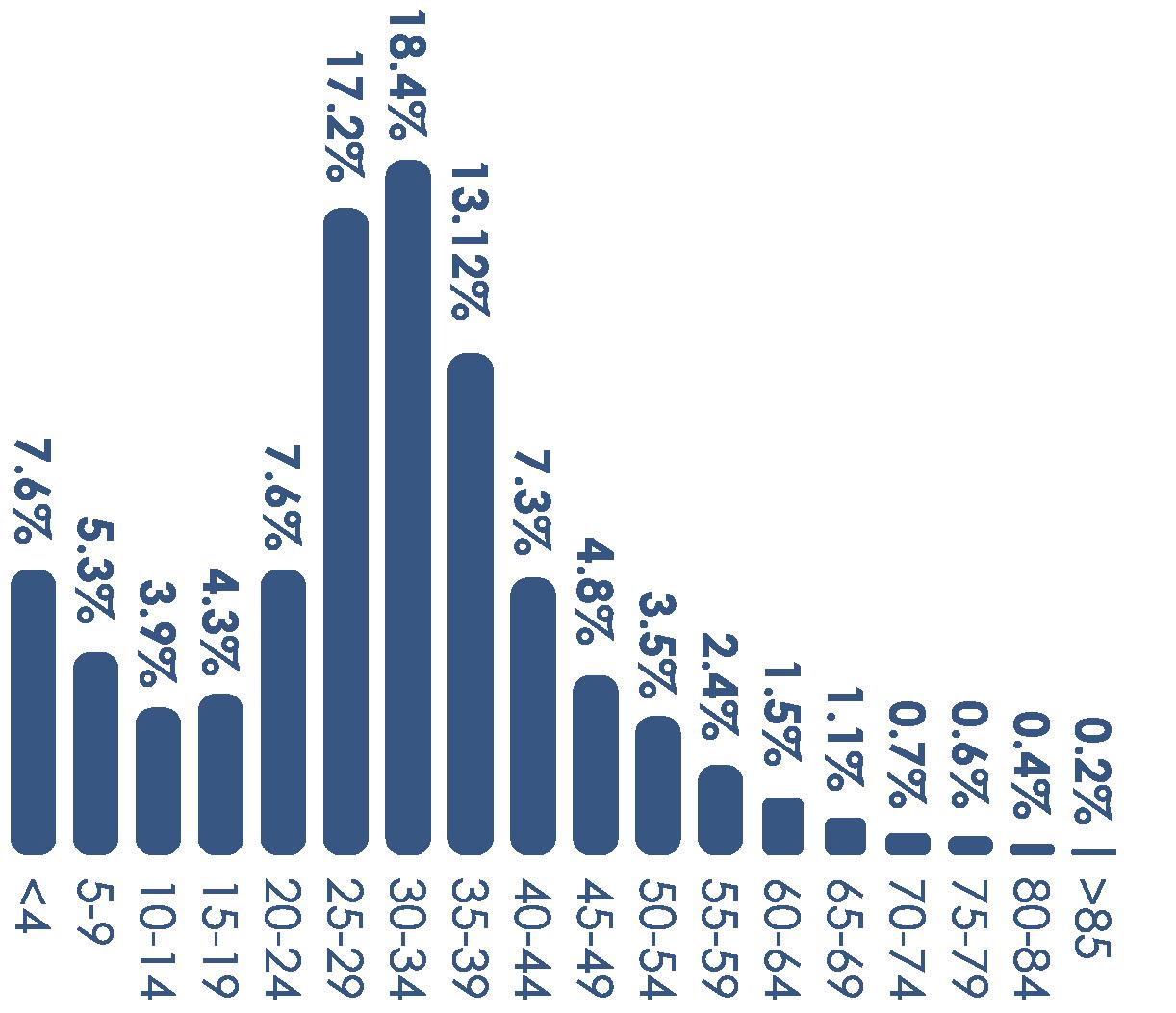
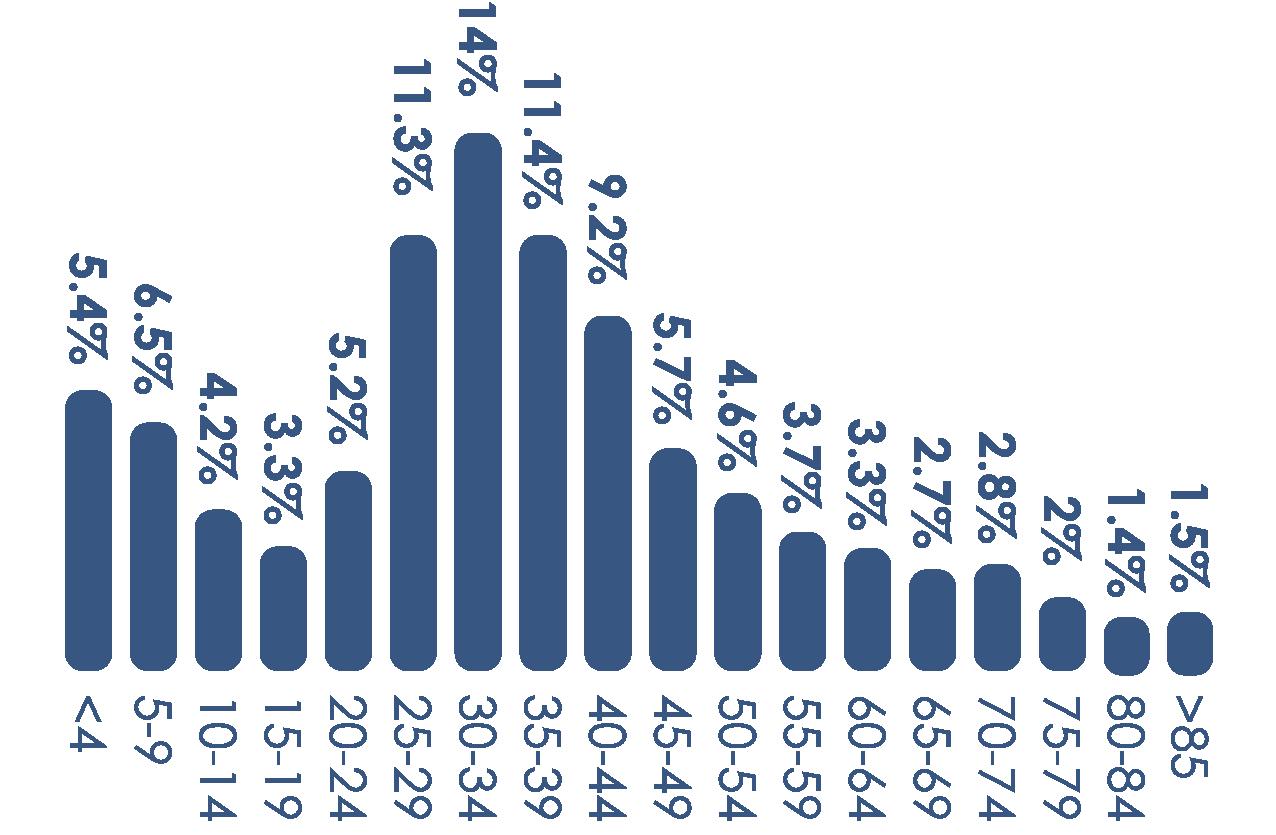
Dominant age group and gender ratio of the residents of a ward is controlled within the study. Both Kidbrooke Village & Sutcliffe and Greenwich Peninsula have dominant ages group of 30-34 years old (figure 9 and 10) with a female majority (figure 11 and 12).
Figure 11: Gender Ratio of Kidbrooke Village & Sutcliffe - data from Office of National Statistics (Meroni, 2024)
Figure 12: Gender Ratio of Greenwich Peninsula - data from Office of National Statistics (Meroni, 2024)
Figure 9: Age range of Kidbrooke Village & Sutcliffe - data from Office of National Statistics (Meroni, 2024)
Figure 10: Age range of Greenwich Peninsula - data from Office of National Statistics (Meroni, 2024)
Methodology
Economic Characteristics of Demographics
Percentage of economically active households (figure 13 and 14), education level above a 4 (figure 15 and 16), and households deprived in 1 dimension (figure 17 and 18) is controlled within a 10% margin of leniency.
Education
Level 4 and above
Level 1-3
No Qualification
Hate Crime Opportunities
Ethnicity (figure 19 and 20) and Religion (figure 21 and 22) is also kept within 10% difference between Wards. This helps minimise changes in crime rates on the basis an estate suffers from more hate crime given a larger presence of minority groups.
Active (Employed) Inactive
Active (Unemployed)
Apprenticeship
Other Qualification
Household
Not deprive Deprived in 1 Dim. Deprived in 2 Dim. Deprived in 3 Dim.
Dependent Variables
The variable that differs between the cases are the place-based crime prevention strategies employed throughout the estates. These are identified through a visual audit desktop study of the built environment. Conducted with Google Maps and Google Earth. The strategies are identified through the table produced is figure 8.
The desktop study focuses on analysing areas within the cases where crime has been reported in Police databases. These areas are of high interest for the study and thoroughly assessed. This method seeks to understand and confirm patterns between areas where crime occurs, and the presence of either New Urbanist or Fortress Mentality leaning crime prevention strategies.
Figure 13: Economic activity of Kidbrooke Village & Sutcliffe (Meroni, 2024)
Figure 15:
Level of Kidbrooke Village & Sutcliffe (Meroni, 2024)
Figure 17:
Deprivation of Kidbrooke Village & Sutcliffe (Meroni, 2024)
Figure 19: Ethnicity of Kidbrooke Village & Sutcliffe (Meroni, 2024)
Figure 14: Economic activity of Greenwich Peninsula (Meroni, 2024)
Figure 16: Education Level of Greenwich Peninsula (Meroni, 2024)
Figure 18: Household Deprivation of Greenwich Peninsula (Meroni, 2024)
Kidbrooke Village & Sutcliffe
Figure 20: Ethnicity of Greenwich Peninsula (Meroni, 2024)
Defining- Bounding the Cases
Data Collection
The necessary on-site data collection discussed above is extracted within the following confinements/ boundaries to the cases. The cases’ area of containment is strictly drawn at the streets immediately surrounding the buildings which make up the complex; the sidewalk of these roads is included in the observations. This ensures crimes which might not happen within the physical boundary of the estate but would nevertheless be witnessed by a resident are included in the data.
Moreover, crime prevention data strictly affecting public movement is collected; any other crime prevention strategy is noted as a possible ‘uncontrolled’ variable. These ‘uncontrolled variables’ may help address rival explanations for the findings in the discussion chapter.
Method Often referred to as a comparative design, the study determines the extent to which the application of public reducing/ enhancing strategies might contribute to a direct difference in the presence of crime within an estate. Data is therefore collected on the measured variables to analyse any potential predictive power between their relationships. Data from multiple sources of evidence is collected to increase the construct validity of the research design as well as encourage convergent lines of inquiry between these diverse sources. The presence of crime is identified with the following methods: Archival records research and Physical artefact observations
Archival Records Research
These records are from publicly accessible data collected by the Metropolitan Police of London and provide extensive quantitative data regarding past crimes which occurred within the boundary of the cases. The data collected accounts to one year of reported crimes - 2023 - compiled and represented over a plan of the estate to identify the areas of interest within the estate’s boundary. It is important to note not all crimes are reported to the police; therefore, these archival records do not represent a complete representation of the truth. Additionally, the geo-location associated
with a crime might not be 100% accurate and should only be taken as an indication as to where the crime occurred rather than undisputed fact. As the introduction of the thesis discusses, a key research objective is assessing the effectiveness of specific crime prevention principles in isolation from other strategies encompassing the overarching theory; all performed within an unrelated case study. Therefore, the physical manifestation of these strategies is not as explicit and clear as urban environments designed through guidance of a place-based crime prevention theory. Nevertheless, the evidence limits interpretation whenever possible.
Physical Artefact Observations
The cases will be explored through the use of Google Maps and Google Earth during which the built environment will be assessed against the strategies table (figure 8) to identify the presence of crime-preventing architecture. Visual evidence through means of sketches will prove the existence of the strategies as well as the physical form they have adopted. This data will be collected and represented visually over a plan of the estate. This plan will display which crime prevention strategies are found in the built fabric and where.
Data Analysis Methods
The data collected is comparatively analysed for potential power between the relationship of crime and the presence of public affecting crime prevention strategies. Nevertheless, as only two estates are being assessed these are “too few in number to serve as an adequately sized sample to represent any larger population” (Groat and Wang 2013). Therefore even if a statistical significance is found, the relationship between the variables might not be necessarily applicable to other cases.
Behaviour
“Someone acting in a manner that causes or is likely to cause harassment, alarm or distress to one or more people not living in the same household as the perpetrator. “ (Police.UK)
“Burglary is the theft, or attempted theft, from a premises where access is not authorised. Damage to a premises that appears to have been caused by a person attempting to enter to commit a burglary, is also counted as burglary.” (Police.UK)
“A broad category of sexual offences, including Indecent Assault and Unlawful (under age) Sexual Intercourse.” (Police.UK)
“Where property is intentionally destroyed or damaged, not necessarily to gain entry to premises or a vehicle.” (Police.UK)
“Theft from a person, motor vehicle, bikes, residential or non-residential property and more. Plus the storage, transport or attempted resale of property after a theft has occurred.” (Police.UK)
Violence Against the Person
“Includes a range of offences from minor offences such as harassment and common assault, to serious offences such as murder, actual bodily harm and grievous bodily harm.” (Police.UK)
“Possession, consumption, supply of or the intent to supply illegal drugs.” (Police.UK)
“Theft with the use of force or a threat of force. Both personal and commercial robbery are included. Snatch theft is not included.” (Police.UK)
Kidbrooke
Village & Sutcliffe Area Profile
Diagrams depict Kidbrooke & Sutfcliffe demographic data within which Kidbrooke Village estate is located. These statistics demonstrate the controlled variables between the two cases which make up the case stud; and may offer insights to explaining crime rates in the discussion section of the paper. The raw data was collected from The Office of National Statistics.
Figure 11: Gender Ratio of Kidbrooke Village & Sutcliffe (Meroni, 2024)
Figure 13: Economic Activity of Kidbrooke Village & Sutcliffe (Meroni, 2024)
Figure 19: Ethnicity of Kidbrooke Village & Sutcliffe (Meroni, 2024)
Figure 9: Age range of Kidbrooke Village & Sutcliffe (Meroni, 2024)
Figure 21: Religion in Kidbrooke Village & Sutcliffe (Meroni, 2024)
Figure 23: Location of Kidbrooke Village & Sutcliffe (Meroni, 2024)
Figure 15: Education Level of Kidbrooke Village & Sutcliffe (Meroni, 2024)
Figure 17: Household Deprivation of Kidbrooke Village & Sutcliffe (Meroni, 2024)
Kidbrooke Village Crime Hotspots
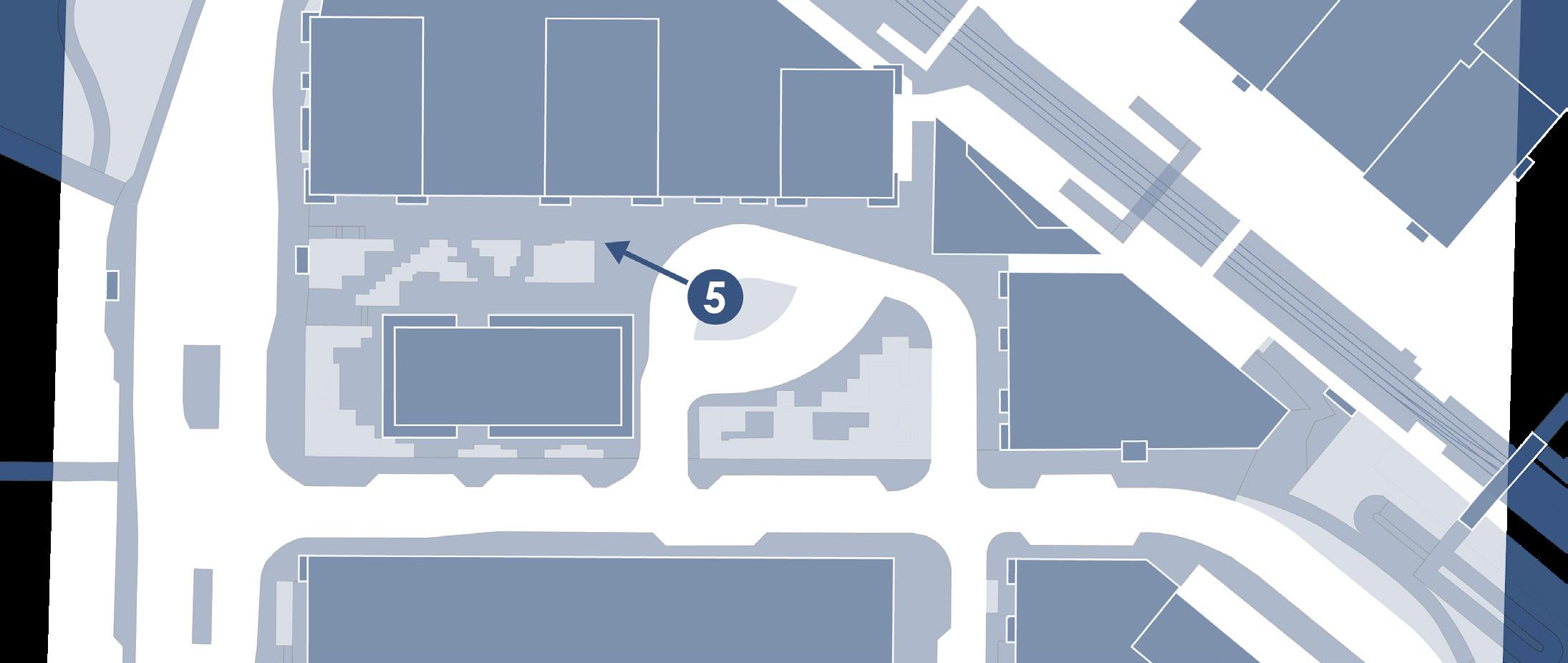
The crime data is recorded through the publicly accessible database: Police.UK. The data shows 4 main crime areas within Kidrbooke Village: A,B,C and D.
Crime Hotpot A will not be considered in the discussions as the area does not belong to the public realm.
Between B, C and D the total crimes committed in 2023 are 161 with the most common crime being Violence/ Sexual offences.
Hotspot B indicates the highest crime within the estate with 115 crimes; while hotspot C has the lowest amount of committed crimes: 15.
Figure 24: Kidbrooke Village Crime Hotspots Map (Meroni, 2024)
Results
Kidbrooke Village Crime-Prevention Strategies
Figure 25 shows all the crime prevention strategies which are employed in the built environment of the estate. Only strategies involving public enhancing or mitigating effects have been highlighted as observed through the desktop study.
Figure 26 depicts a quantitative comparison accounting for the highlighted New Urbanist principles against the Fortress Mentality ones. To indicate which approach is more common within the estate.
Figure 27 instead compares the overall presence of specific crime-prevention strategies focusing on public enhancing/ mitigating purposes. The principles included in the chart are the ones demonstrated to be contradictory between CPTED and Defensible Spaces as discussed in the Literature Review (figure 8).
Figure 25: Kidbrooke Village Crime-Prevention Map (Meroni, 2024)
Figure 26: Predominant School of thought in Kidbrooke Village (Meroni, 2024)
Figure 27: Predominant Crime-Prevention Principles in Kidbrooke Village (Meroni, 2024)
Employed Crime-Prevention Strategies
Territoriality
Discouraged N/A
Assign specific zones (front yards, backyards) to specific households
Integration of community-focused amenities/ areas for residents use only
Place entrances oriented toward public streets giving residents direct visibility over adjacent areas
The use of identifiable landmarks to encourage community pride
Incorporation of neighbourhood/ corporate branding
Figure 28: Comparison of CPTED and Defensible Spaces crime-prevention strategies as observed in the built environment - Strategies employed in Kidbrooke Village highlighted in orange (Meroni, 2024)
Installation of protective grilles, shutters, or bars on windows
Installation of barriers to control entry into private or restricted areas
Sharp-edged fencing/ spikes on walls
Designate mixed-use spaces that naturally attract a variety of people
Integrate residential and commercial land uses Placement of public amenities in areas that benefit from oversight and promote continuous foot traffic
Use of physical boundaries to define private, semi-private, and public spaces
Visual markers to delineate: resident areas, parking, visitor zones, private property, restricted areas, and community watch presence
Design curving, well-lit paths that guide people through safe areas and limit access to secluded spots
Trim or avoid using large shrubs or hedges around entryways and paths
Positioning of buildings and pathways to allow for natural surveillance from homes and prevent secluded areas
Discouraged
Conversion of traditional public streets into semi-private or private spaces to limit unwanted traffic
Implementation of traffic-calming measures to discourage non-resident usage of residential areas
Creation of neighbourhood entry and exit points
Limiting the number of through-paths or access points to discourage easy movement across a property
Avoiding creating dense, enclosed areas that could conceal potential criminal activity
Maximise sight lines in public spaces to enhance the perceived presence of natural surveillance
Developments of parks and public spaces that are actively used and encourage social engagement
Ensure these areas are well frequented
Ensure the layout of parks or communal green spaces have inviting seating and gathering spots to foster positive activities
Figure 28 uses the strategies table produced as an outcome to the literature review (figure 8)to highlight crime mitigating techniques observed in the built environment of Kidbrooke Village.
Both CPTED and Defensible Space strategies are common within the estate with a strong influence in Gathering Spaces and Mixed use through CPTED; and Territoriality through Defensible Spaces.
Internal courtyards sorrounded by residential blocks
Layout promotes territorial attitudes over gathering space
Non residents utilising the gathering space are easily spotted
Results
Sketches of Key Areas
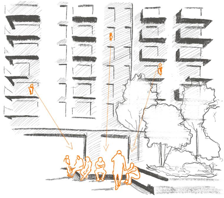
Figure 29 shows which part of Kidbrooke Village the sketches depict. Within the sketches the colour orange highlights the main crime-prevention being showcased by the drawing.
Figure 30 located in the central square shows the open design of the gathering space highlighting the mixed use properties of it.
Mixed Use development includes:
1. Sainsbury’s Local
2. Tesco Express
3. Kidbrooke Southeastern railway station
4. Puregym
5. Chemcare Pharmacy
6. Kidbrooke Nursery
7. The Depot (pub)
Figure 3 also located in the central square depicts the public seating, planting and water features which decorates it. It also highlights the presence of residential blocks in its proximity.
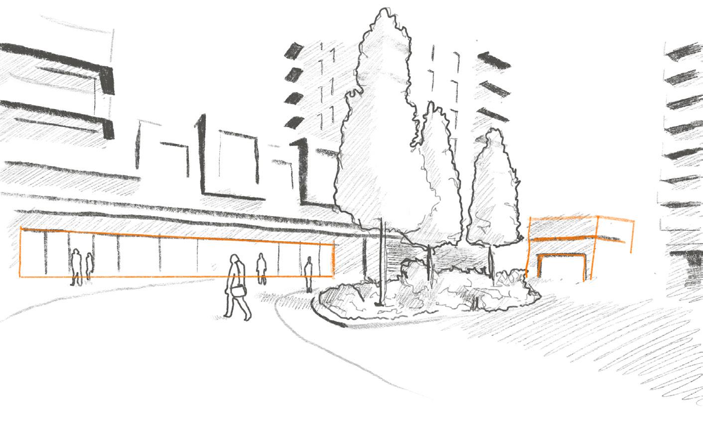
Figure 29: Kidbrooke Village Map showing location of sketches (Meroni, 2024)
Figure 30: Mixed use of the central Square
Figure 31: Gathering space seating under natural surveillance (Meroni, 2024)
Sketches of Key Areas
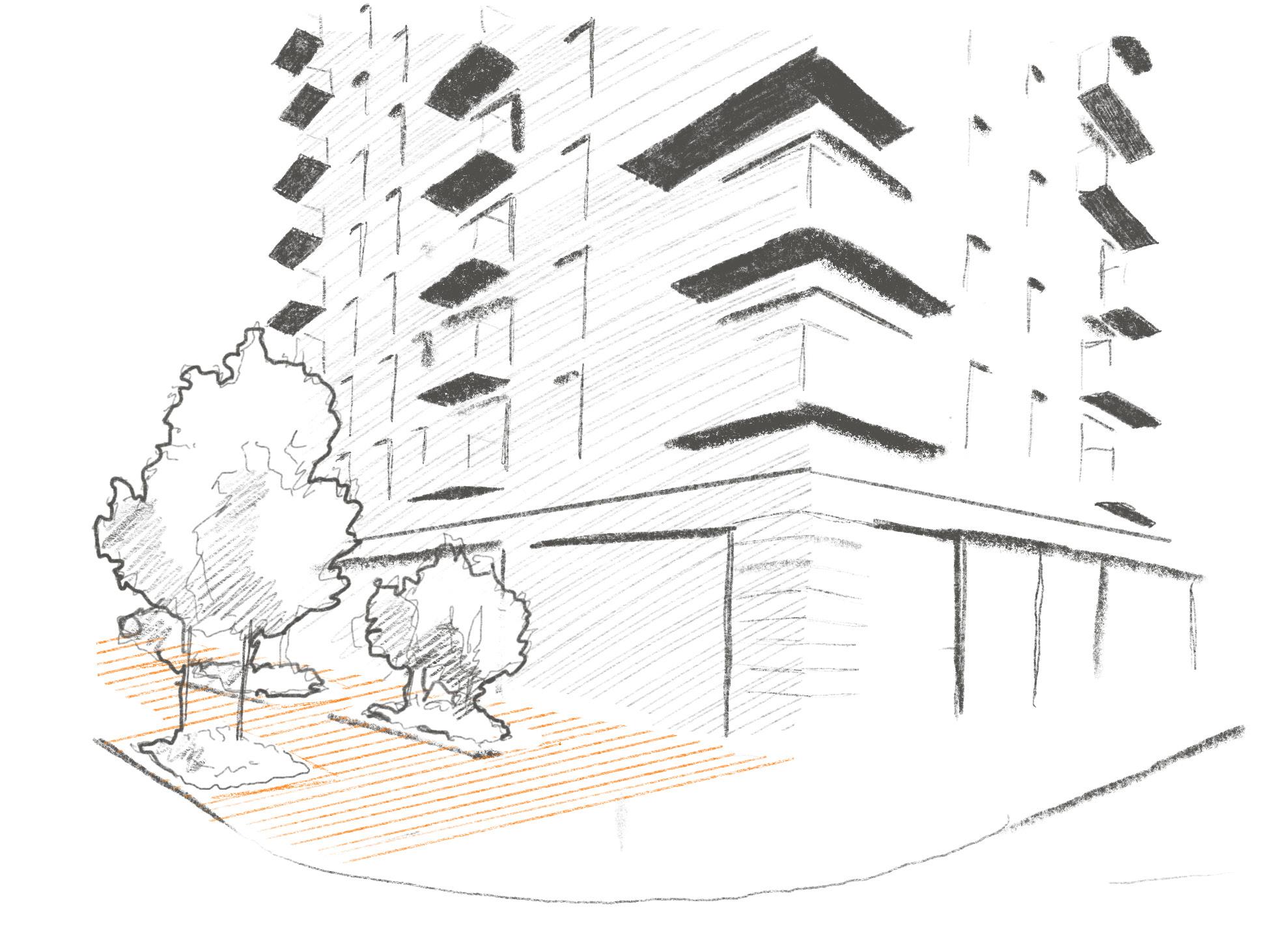
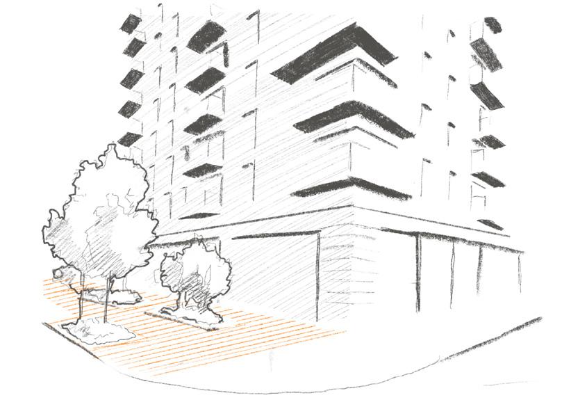
Figure 33 shows which part of Kidbrooke Village the sketches depict. Within the sketches the colour orange highlights the main crime-prevention being showcased by the drawing.
Figure 34 located at the back of the train station behind the central square, Depicts the site movement and access routes of this area.
Figure 35 is located on the sidewalk south of the central square. However, the following feature is also applied to the square itself. The sketch depicts distinctly different paving texture and material to public roads external to the estate.
Planting between a residential block facade and road is also a repeated feature throughout the estate.
Figure 32: Kidbrooke Village Map showing location of sketches 2 (Meroni, 2024)
Figure 33: Back side of Southeastern train station (Meroni, 2024)
Figure 34: Change in paving texture (Meroni, 2024)
Results
Sketches of Key Areas
Figure 35 shows which part of Kidbrooke Village the sketches depict. Within the sketches the colour orange highlights the main crime-prevention being showcased by the drawing.
Figure 36 is located off the side of the central square however, it appear multiple times throughout the estate (Refer to fig. X for more information). It depicts the use of planting to place branding of the estate.
The inscription on the vase is as follows:
“Kidbrooke
Village - Royal Borough of GreenwichSE3”
Figure 35: Kidbrooke Village Map showing location of sketches 3 (Meroni, 2024)
Figure 36: Example of planting vase with estate branding (Meroni, 2024)
Greenwich Peninsula Area Profile
Diagrams depict Greenwich Peninsula demographic data within which Millennium Village estate is located. These statistics demonstrate the controlled variables between the two cases which make up the case stud; and may offer insights to explaining crime rates in the discussion section of the paper.
Figure 12: Gender Ratio of Greenwich Peninsula (Meroni, 2024)
Figure 14: Economic Activity of Greenwich Peninsula (Meroni, 2024)
Figure 20: Ethnicity of Greenwich Peninsula (Meroni, 2024)
Figure 10: Age range of Kidbrooke Village & Sutcliffe (Meroni, 2024)
Figure 22: Religion in Greenwich Pneinsula (Meroni, 2024)
Figure 16: Education Level of Greenwich Peninsula (Meroni, 2024)
Figure 18: Household Deprivation of Greenwich Peninsula (Meroni, 2024)
Figure 37: Location of Greenwich Peninsula (Meroni, 2024)
Results
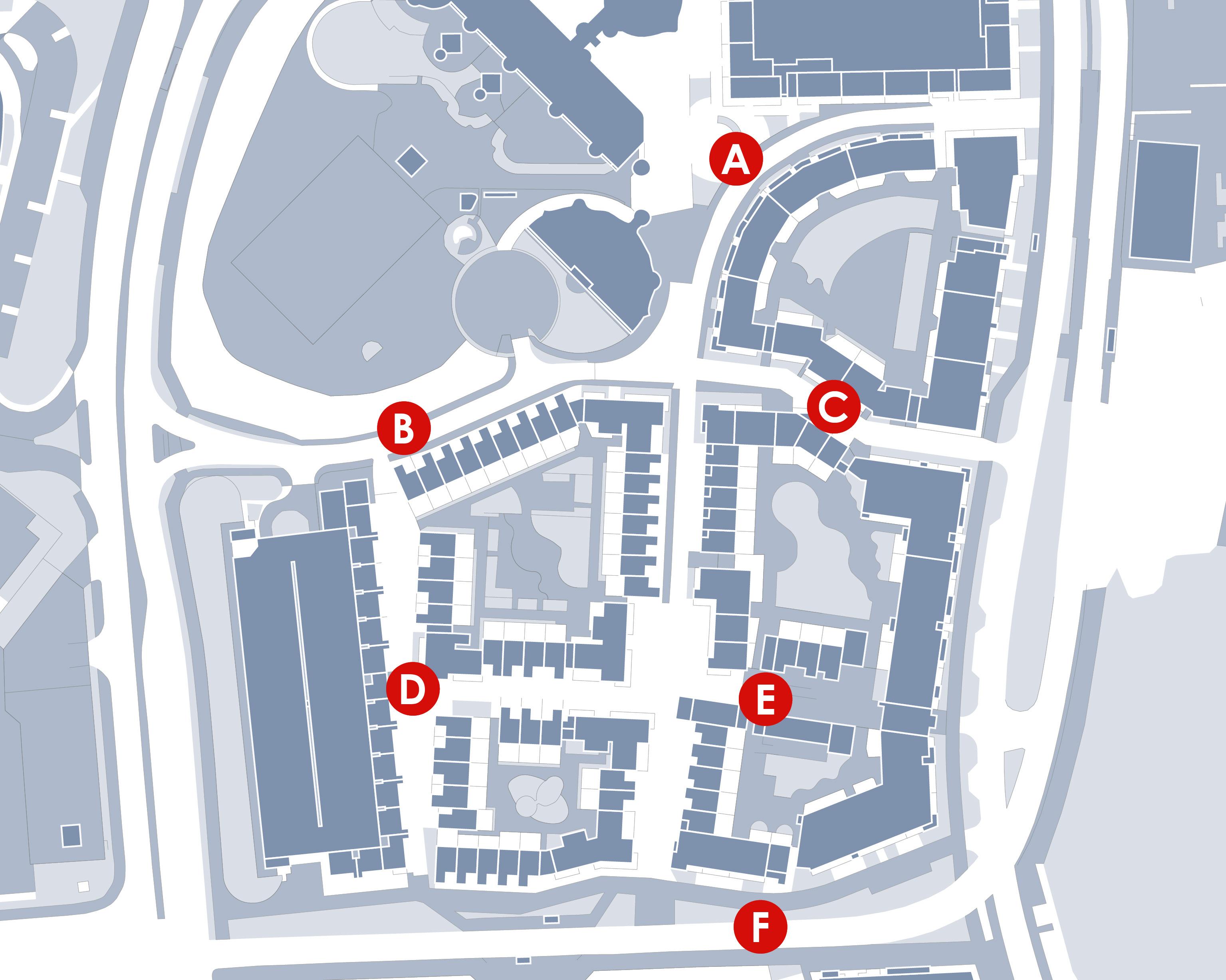
Village Crime Hotspots Map
The crime data is recorded through the publicly accessible database: Police.UK. The data shows 6 main crime areas within Millennium Village: A, B, C, D, E and F
The total crimes committed in 2023 are 155 with the most common crime being Vehicle Theft.
Hotspot B indicates the highest crime within the estate with 58 crimes, while hotspot E has the lowest amount of committed crimes: 12.
Millennium
Figure 38: Millennium Village Crime Hotspots Map (Meroni, 2024)
Results
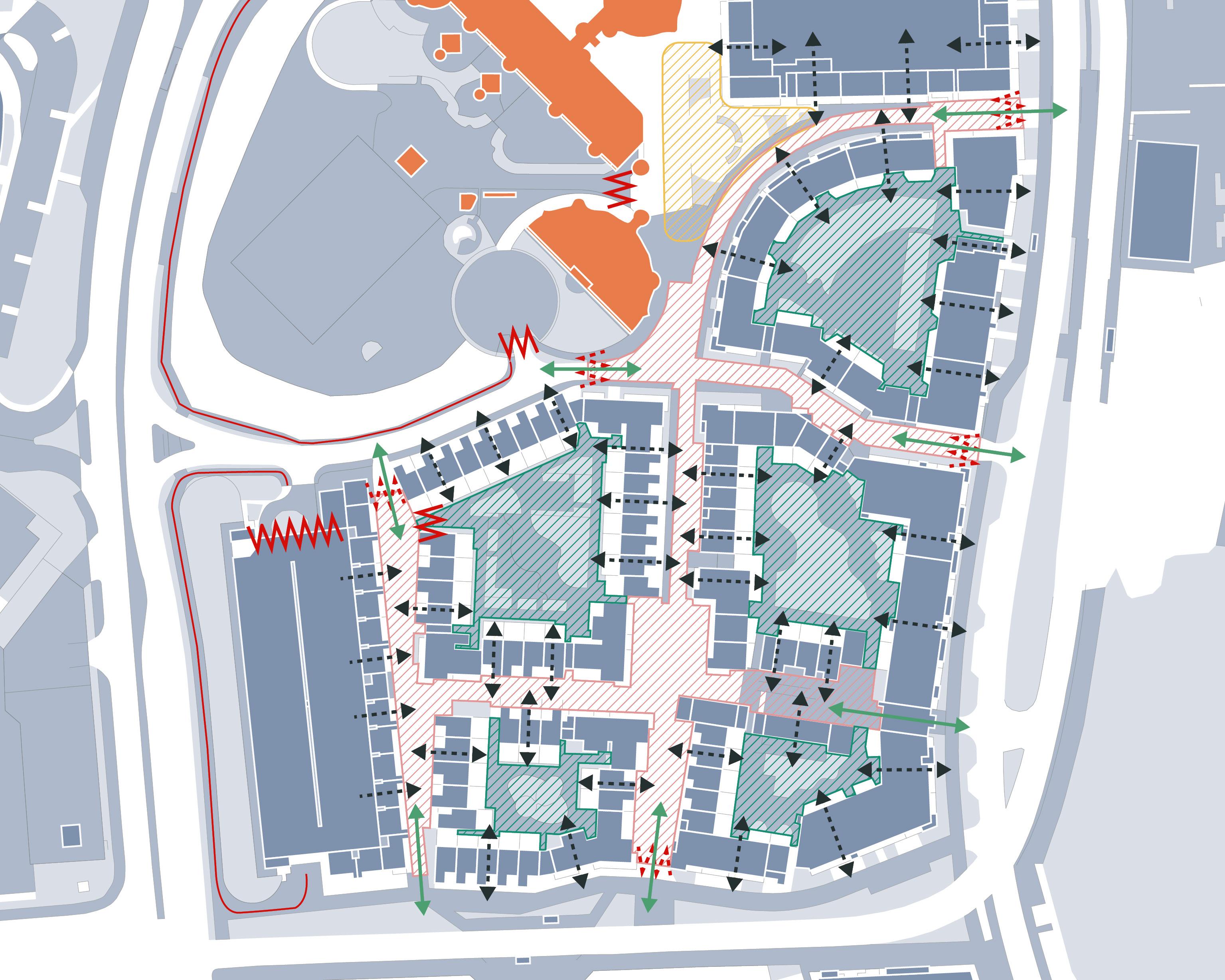
Millennium Village Crime-Prevention Strategies Map
Figure 39 shows all the crime prevention strategies which are employed in the built environment of the estate. Only strategies involving public enhancing or mitigating effects have been highlighted as observed through the desktop study.
Figure 40 depicts a quantitative comparison accounting for the highlighted New Urbanist principles against the Fortress Mentality ones. To indicate which approach is more common within the estate.
Figure 41 instead compares the overall presence of specific crime-prevention strategies focusing on public enhancing/ mitigating purposes. The principles included in the chart are the ones demonstrated to be contradictory between CPTED and Defensible Spaces as discussed in the Literature Review.
Pedestrian Gate
Gate
Figure 39: Millennium Village Crime-Prevention Map (Meroni, 2024)
Figure 40: Predominant School of thought in Millennium Village (Meroni, 2024)
Figure 41: Predominant Crime-Prevention Principles in Millennium Village (Meroni, 2024)
Discouraged N/A
Designate mixed-use spaces that naturally attract a variety of people
Placement of public amenities in areas that benefit from oversight and promote continuous foot traffic
Integrate residential and commercial land uses
Use of physical boundaries to define private, semi-private, and public spaces
Visual markers to delineate: resident areas, parking, visitor zones, private property, restricted areas, and community watch presence
Design curving, well-lit paths that guide people through safe areas and limit access to secluded spots
Trim or avoid using large shrubs or hedges around entryways and paths
Positioning of buildings and pathways to allow for natural surveillance from homes and prevent secluded areas
Avoiding creating dense, enclosed areas that could conceal potential criminal activity
Maximise sight lines in public spaces to enhance the perceived presence of natural surveillance
Developments of parks and public spaces that are actively used and encourage social engagement
Ensure these areas are well frequented
Ensure the layout of parks or communal green spaces have inviting seating and gathering spots to foster positive activities
Figure 42 uses the strategies table produced as an outcome to the literature review (figure 8) to highlight techniques observed in the built environment of Millennium Village to reduce crime rates.
Both CPTED and Defensible Space strategies are common within the estate with a strong influence in Access Control through both CPTED and Defensible Spaces; and Gathering space as well as Territoriality through Defensible Spaces.
Assign specific zones (front yards, backyards) to specific households
Integration of community-focused amenities/ areas for residents use only
Place entrances oriented toward public streets giving residents direct visibility over adjacent areas
The use of identifiable landmarks to encourage community pride
Incorporation of neighbourhood/ corporate branding
Figure 42: Comparison of CPTED and Defensible Spaces crime-prevention strategies as observed in the built environment - Strategies employed in Millennium Village highlighted in orange (Meroni, 2024)
Discouraged Installation of protective grilles, shutters, or bars on windows
Installation of barriers to control entry into private or restricted areas
Sharp-edged fencing/ spikes on walls
Conversion of traditional public streets into semi-private or private spaces to limit unwanted traffic
Implementation of traffic-calming measures to discourage non-resident usage of residential areas
Creation of neighbourhood entry and exit points
Limiting the number of through-paths or access points to discourage easy movement across a property
Internal courtyards sorrounded by residential blocks
Layout promotes territorial attitudes over gathering space
Non residents utilising the gathering space are easily spotted
Results
Sketches of Key Areas
Figure 43 shows which part of Millennium Village the sketches depict. Within the sketches the colour orange highlights the main crime-prevention being showcased by the drawing.
Figure 44 located in the central square shows the open design of the gathering space highlighting the public seating, planting and sculptures which decorates it. It also highlights the presence of residential blocks in its proximity.
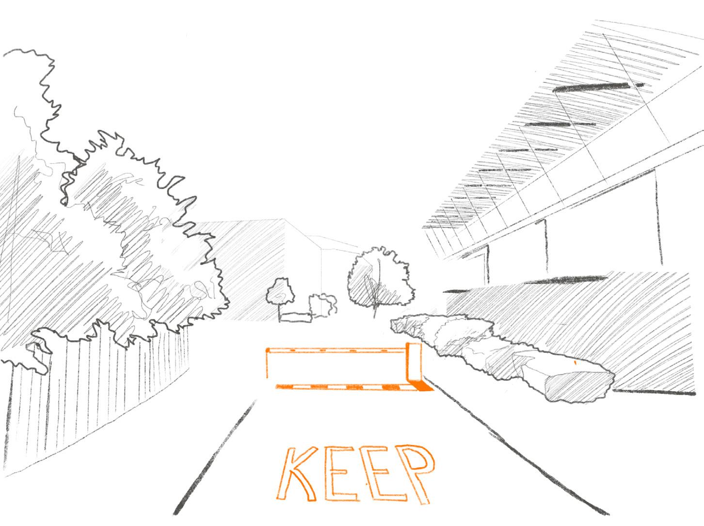
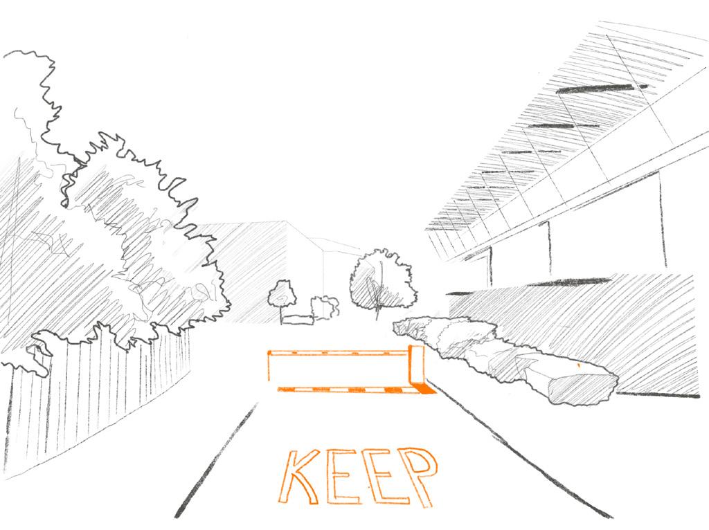
Figure 45 located in the North West entrance depicts the use of vehicle gates and road bumps. These features are not exclusive to this entrance and can be found at every access route into the estate.
Figure 43: Millennium Village Map showing location of sketches (Meroni, 2024)
Figure 44: Main public square (Meroni, 2024)
Figure 45: Vehicle gate as shown by the North West entrance (Meroni, 2024)
Results
Sketches of Key Areas
Figure 46 shows which part of Millennium Village the sketches depict. Within the sketches the colour orange highlights the main crime-prevention being showcased by the drawing.
Figure 47 located off the North West entrance to the estate depicts a car park enclosed by fencing and thick foliage
Figure 48 located in the North West residential block depicts the internal courtyard of the block adorned with extensive vegetation, privacy and seating options.
Figure 46: Millennium Village Map showing location of sketches 2 (Meroni, 2024)
Figure 47: Car Park to the North East (Meroni, 2024)
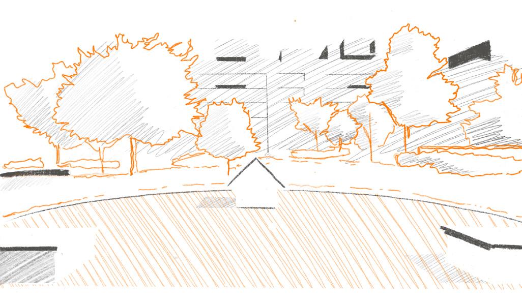
Figure 49 shows which part of Millennium Village the sketches depict. Within the sketches the colour orange highlights the main crime-prevention being showcased by the drawing.
Figure 50 located towards the East entrance. It depicts the narrow winding routes which characterise the estate. Vegetation and shrubbery often adorning the paths.
Figure 49: Millennium Village Map showing location of sketches 3 (Meroni, 2024)
Figure 50: Example of paths throughout the estate (Meroni, 2024)
Discussion
The aim of the paper is to establish a trend between hotspots for crime in residential estates and the application of crime prevention strategies in their surrounding area. It specifically assesses the two predominant theories, CPTED and Defensible Spaces, which inform the government publication Safer Places.
Through a case study of the estate complexes Kidbrooke Village and Millennium Village; the effectiveness of place-based crime prevention strategies are compared. Focusing on either New Urbanist public enhancing principles or Fortress Mentality public mitigating strategies assessing which school of thought results in lower crime rates and whether combining the two (as is the approach of Safer Places) is an option worth considering.
The accumulated results suggest at a high level that estates with average crime rate boroughs employ a mixed theoretical approach. Both Kidbrooke Village and Millennium Village demonstrate application of both CPTED and Defensible Spaces strategies.
Moreover, both cases appear to have an area of relatively high crime immediately adjacent to areas with relatively low crime or no reported crime at all. A discussion of this by-product is held in gathering spaces regardless of its CPTED or Defensible Spaces design.
Furthermore, although Kidbrooke Village reported more crimes in 2023 than Millennium Village, the analysis identifies a predominant New Urbanist approach supported by elements of Fortress Mentality was found to be a more effective crime mitigater than a predominantly Fortress Mentality design supported by elements of New Urbanism.
A Mixed Approach to Crime Prevention
A possible explanation for both estates adopting CPTED and Fortress Mentality designs might lie within user preferences. Developers will design residential complexes with the goal of maximising actively occupied units. Therefore the design of the estates can be argued to generally follow consumer preferences to ensure it provides features and amenities sought after by potential residents. When considering the demographics of the two cases one can assume these estates target family units. This may suggest these households prefer living in conditions that are neither completely isolated from the public as dictated by Fortress Mentality, nor completely permeable and accessible by the public as is the case with New Urbanism. These findings suggest the public prefers the convenience and amenities offered by New Urbanism with added layers of security associated with fortress mentality.
It can therefore be argued that the mixed approach of the government publication Safer Places is not only the most realistic option but also more useful to developers. Planning guidances such as these are published to support and assist developers in making successful design decisions. Furthermore, given the lack of regulation explicitly demanding specific crime prevention, the publication can offer suggestions which align with developers
goals and demographics. Both of which indicate a mixed approach to crime prevention. Therefore Safer Spaces offers the balanced solution for both requirements. On the other hand, the analysis suggests implementing features of Fortress Mentality into a largely New Urbanism development is more successful than its viceversa; especially when dealing with the public enhancing/ mitigating strategies in question. This is supported by the data and findings surrounding the public square feature of both estates (figure 30 and 44)
Figure 30: Mixed use of the central Square (Meroni, 2024)
Figure 44: Main public square (Meroni, 2024)
Discussion
A Mixed Approach to Crime Prevention
Fortress Mentality into New Urbanism
Kidbrooke Village demonstrates an application of more New Urbanist principles than Fortress Mentality (figure 26). Its outcome resulting in an environment which embraces the public while still reminding it of the private nature of the estate. At the heart of the complex lies a central public square. It was reported to suffer 15 crimes over 2023, which not only is the area with the lowest amount of reported crimes within the estate; but it is so by a considerable margin.
The use of the square is further promoted through the inclusion of inviting seating (figure 31) . Green infrastructure provides shading and a water feature enhances the biophilic design of the space. The square is designed to attract more people inviting them to make use of its available seating. All distinctly CPTED focused strategies for mitigating crime by creating thoughtful gathering spaces which foster constant, positive activity and footfall on site. Ultimately decreasing the opportunity for crime through social cohesion nurturing persistent natural surveillance.
Surprisingly, even though the design of the square is strongly New Urbanist, there are several Defensible Space strategies employed throughout.
The application of Mixed use development surrounding the square (figure 30) includes commercial buildings, Leisure facilities and a train station. Such an array of different building typologies is fundamentally a CPTED strategy which ensures constant use of the square throughout the day. Furthermore, the inclusion of a pub and train station further provides legitimate reasons for the square to be occupied during later hours of the evening.
The study found examples of territorial principles and access control. Extensive use of: branding and landmark elements in the form of planters (figure 36), the application of traffic calming measures through pedestrianisation and bollards, the explicit change in paving texture contrasting the adjacent public road (figure 34). All of these strategies explicitly indicate this square is a pseudo public space. It is privately owned by the estate and its residents; but it welcomes public users. It enforces the territorial attitudes of the residents towards this gathering space culminating in a square that is well vigilated and maintained.
On the other hand, although not many crimes were reported within the square, 15 instances were committed despite the crime prevention strategies. A possible downfall might be in its mixed use. The presence of the train station brings vast amounts of footfall to the square; theoretically a positive feature according to CPTED and New Urbanism. However, the last train to stop at this station does so at 1:15am; well past the closure of all the other mixed use services in proximity to the square. Such conditions imply a limited number of train users will inhabit the square during periods of no other activity and therefore surveillance. Moreover, the late hours will see a decrease in passive surveillance provided by residents and their square facing windows as they are likely to be sleeping.
Another consideration which may negatively affect the crime rates is the presence of 6 distinctive access routes to the square (figure 25). Both CPTED and Defensible Spaces argue in favour of minimising access routes into a space whether public or private; a strategy not employed in this instance. This large number of paths can be contextualised, as an escape route.
Figure 26: Predominant School of thought in Kidbrooke Village (Meroni, 2024)
Figure 31: Gathering space seating under natural surveillance (Meroni, 2024)
Figure 34: Change in paving texture (Meroni, 2024)
Figure 36: Example of planting vase with estate branding (Meroni, 2024)
Discussion
A Mixed Approach to Crime Prevention
New Urbanism into Fortress Mentality
Millennium Village demonstrates an application of more Defensible Spaces strategies than CPTED (figure 40) Resulting in an environment which feels largely private and detached from the surrounding area, while simultaneously demonstrating an inadequate instance of public enhancing strategies. This is very evident when analysing its square which appears to be designed for public accessibility but the overarching Fortress Mentality of the estate makes it vastly more isolated. These results align with an increased amount of crimes within the area.
The most telling strategy of Fortress Mentality is the installation of gates at every entrance into the estate (figure 45); a Defensible Spaces strategy within target hardening. Although the gates are for vehicles and do not obstruct access to pedestrians, they imply a gated community. Furthermore, the territorial strategy of changing pavement texture enhances these public mitigating efforts. The study found there is a single mixed use building around the square: a primary school. Indicating the 2nd CPTED principle applied in the context of the square. (Gathering spaces being the 1st CPTED principle). However, schools, are not seen as effective surveillance measures; as was the case with the building typologies observed within Kidbrooke Village. The low levels of independence of children suggest will stay within the school at most times. Therefore unlikely to increase use of the square.
Furthermore, the school adopts a strong target hardening approach via the erection of extensive fencing. This fence is made of wooden slats therefore obstructing views into the square minimising natural surveillance school staff could have offered. These factors result in a square which is likely to maximise activity only twice a day: In the morning when the children are dropped off at school; and in the evening when they are picked back up.
All other findings of the square appear to be designed from a New Urbanist perspective. It has inviting seating (figure 44) which much like Kidbrooke Village square employs vegetation to create areas of shade and attract people. It positions residences to overlook the square. It has multiple paths leading towards it. However, The overall language of the design communicates an estate closed off to the external public. The gates at the entrance (figure 45) could be seen as deterrents, giving the impression of a private square.
Moreover, residents of the estate itself aren’t incentivised to use the square as each block is provided with a private shared courtyard which is better maintained and curated (figure 48). Yet another Defensible Space strategy.
This culminates in a gathering space which appears to be public but is heavily underutilised by both the public and the residents themselves. Thus creating a hotspot for crime within the estate which sees more crime than Kidbrooke village square as well as signifying a significantly larger percentage of total crimes throughout the Millennium Village.
Figure 45: Vehicle gate as shown by the North West entrance (Meroni, 2024)
Figure 40: Predominant School of thought in Millennium Village (Meroni, 2024)
Discussion
A By-Product of Gathering Spaces
An unexpected pattern found in both cases was the presence of a crime hotspot situated adjacent to a lower crime zone within the context of gathering spaces; this discrepancy could be attributed to the creation of interesting views. The previous finding analysed Kidbrooke Village square as a vibrant, actively used amenity which received lower crime rates due to its design. On the contrary, area ‘B’ in figure 24 immediately behind the square (figure 33) suffers the highest crime counts of the entire complex (115 crimes). A possible explanation is in the area’s minimal use of crime prevention strategies from either CPTED or Defensible Spaces.
The public square is largely blocked off by the train station, therefore its benefits discussed above might not extend into this new area. Moreover, the smaller gathering space south east is perhaps slightly too far to positively impact crime rates. Therefore the natural surveillance theoretically created by these two gathering spaces might not be as effective for this area. The only crime prevention strategies present is the mixed use provided by the train station; which as prior mentioned can potentially be problematic due to its late operating hours. As well as surveillance provided by the residences overlooking the area.
The findings highlight that simultaneously to the low levels of crime prevention strategies, area B adopts characteristics which according to the literature review directly contrast crime mitigating design. The area parallel to the train tracks contains 5 distinctive access routes (figure 25 and 33), a point of concern according to both CPTED and Defensible Spaces. Two of these paths lead to the central square; however, these are unlikely to be used given several more inviting routes leading to the gathering space. Similarly, users of the train station are likely to exit through the main entrance situated on the square rather than the back entrance into the area of concern. Hence, it could conceivably be hypothesised the area is severely underutilized, and due to its architecture, isolated from the rest of the estate. There appears to be no valid reason for anybody to occupy this space other than riding the train.
These observations may suggest any potential natural surveillance becomes negligible as a byproduct of the square next door. The literature review discussed Jane Jacobs’ praise for well designed sidewalks in fostering a vibrant and lively atmosphere as essential for promoting safety through natural surveillance. It provides residents and pedestrians an interesting scenery to look at - people watching. Enhancing the “eyes on the
street” (Jacobs 1961) effect. In this case, there is no incentive for residents to look out the back of their block towards the train platform due to a lack of interest. This is further detrimental by juxtaposing it with a view towards the more eventful square.
This hypothesis is consistent and arguably better supported by the findings of Millennium Village. The area of interest in this case are the private block courtyards and their adjacent public areas.
In this case crime hotspot B represented the most frequent amount of crimes within the complex (53 crimes); however the findings demonstrate several applications of Defensible Spaces strategies within the area. Most notable is the use of Target Hardening and Access Control approaches. Fences, gates, shrubbery, traffic calming measures and territoriality is employed specifically to fortify the car park situated in the area (figure 47). However, contrary to expectations, the study reported vehicle theft being the most predominant criminal activity in the area, occurring 35 times in 2023.
Figure 33: Back side of Southeastern train station (Meroni, 2024)
Figure 47: Car Park to the North East (Meroni, 2024)
Discussion
According to Fortress Mentality it should be both easy for residents to spot any criminal activity and hard for criminals to gain access to the car park to commit any crime. The parallel residential units position their entrance towards the car park and incorporate glazing with a direct view to the area of high crime (figure 39). The road has a single access route at each extremity suggesting easy control over users on the road; and as mentioned, the car park itself is surrounded by a fence. As assessed by both the literature review and findings, there should be minimal criminal activity; but this is not the case.
Kidbrooke Village example suggests the well curated and actively used public square creates a vastly more isolated space adjacent to it. Similarly this problem in MIllennium Village may be a byproduct of the shared private courtyard of the perimeter block. The courtyards provide inviting seating, biophilic elements, and each house is equipped with a terrace overlooking it (figure 48).
In contrast, the glazing facing the crime hotspot is comparatively limited and its views uninteresting. Therefore, there may be a case where, like Kidbrooke village, the residents prefer looking towards the courtyard rather than the road, reducing the effectiveness of natural surveillance. Without which, a relatively low fence (with no spikes) poses an feasibly surpassable obstacle for criminals attempting to gain access to the car park.
Moreover, the extensive shrubbery might be a counterproductive crime prevention strategy: The foliage appears under maintained and overgrown, possibly restricting views into the car park from the residences.
The employed methodology allows for a broad understanding of how both public enhancing and public mitigating crime prevention strategies can affect crime rates; as well as initial suggestions as to how these different approaches may interact with themselves and each other. However, it does not reach empirical results which allow for generalisation. The cases which build up the case study are too few to establish a pattern with a high degree of predictability. Rather, its purpose is to firstly test a different research design to assess the success of crime prevention theory. Accomplished by focusing on individual strategies linked through a thematic concept rather than holistically. In this case the focused strategies relate to the presence of the public in private estate complexes. In this instance, an analytical generalisation may be considered to take the form of a series of working hypotheses to be applied to existing studies so their validity may be further assessed.
Furthermore, the methodological chapter describes in detail the process through which uncontrolled variables have been minimised. It is however important to note there are certain variables that will always be unpredictable due to the nature of chance. There might be more criminals in any area at any given point compared to somewhere else. In the same instance,
police presence across areas may vary at any given moment affecting the presence of crime throughout the cases. Unfortunately, there is no way for the methodology to completely eliminate these and therefore must be considered when interpreting the discussions.
Lastly due to concerns over personal safety the research was executed through a desktop study. Perhaps, physically visiting the cases and executing data collection on site may present some insights which were not highlighted through this study. Involving local residents and participants may additionally offer data relating to the fear of crime which may be contrasted with the reported crime data offering ulterior conclusions. In which case, proper ethical approval would be necessary.
Practical Application of Findings Future Research
The study starts to build a case which highlights the presence of a mixed approach within crime prevention; where theories with either a New Urbanist or Fortress Mentality are employed beside each other. Doing so it argues Safer Spaces may not be as unorthodox a publication as some literature suggested. Additionally, it builds upon the publication to further offer insights as to how the most common crime prevention theories CPTED and Defensible Spaces may be combined with more success within the context of London based estate developments.
Nevertheless, the developed hypothesis: whether mixing Defensible Space strategies within a predominantly New Urbanist complex offers more effective crime prevention than vice-versa. As well as, whether well designed gathering spaces lead to increased isolation and therefore crime in adjacent areas. Are both outcomes of the study which require focused individual research. This dissertation highlights the value of breaking larger theory into smaller strategies. However, it may be beneficial to execute future research one step further. For instance, instead of focusing on assessing 4 contrasting strategies as this paper did; Research focusing on a single principle over a larger case study might produce more generalisable and applicable results.
Conclusion
The research aimed to determine the effectiveness of place-based crime prevention theories focusing on strategies within them which relate to public enhancing/ mitigating approaches. While also assessing whether the two can be combined to emphasise each other’s effects. Based on the quantitative and qualitative analysis of two London based estate complexes: Kidbrooke Village and Millennium Village; it can be concluded that while data suggests a mixed theoretical approach to be representative of real world scenarios, the execution has a caveat.
The results indicate integrating Defensible Spaces strategies within a largely New Urbanist complex to be more effective than the opposite. While also highlighting a new unforeseen effect on gathering spaces and their disadvantage in promoting less surveillance and more isolation in adjacent environments. Such findings raise the question of any uncontrolled variable which may emphasise this effect as well as how an architect might design against this by-product.
Nevertheless, the research presents an alternative approach at studying the effects of crime prevention design hoping to highlight the need to accumulate more specific empirical evidence. A solution to a problem identified in the literature
review. Not only would this simplify the time requirements and extents of future research designs; but as demonstrated by this paper, it may produce unexpected results worth discussing.
Ultimately the creation of more data and evidence, may firstly assist the development of future planning guidance; and secondly could be the catalyst for the first planning regulation demanding the use of architecture to design out crime.
Bibliography
1. Armitage, R. 2006. Predicting and preventing: Developing a risk assessment mechanism for residential housing. Crime Prevention and Community Safety 8(3), pp. 137–149. doi: 10.1057/palgrave.cpcs.8150024.
2. Congress for the New Urbanism. 2024. The Charter of the New Urbanism.
3. Crime and Disorder Act 1998, c.11. Available at: https://www.legislation.gov.uk/ukpga/2012/7/contents/ enacted (Accessed: 17 September 2024).
4. Ellis, C. 2002. The New Urbanism: Critiques and rebuttals. Journal of Urban Design 7(3), pp. 261–291. doi: 10.1080/1357480022000039330.
5. Garland, D. 1996. THE LIMITS OF THE SOVEREIGN STATE: Strategies of Crime Control in Contemporary Society. Available at: https://www.jstor.org/stable/23638075.
6. Gehl, J. and Svarre, B. 2013. How to Study Public Life.
7. Groat, L.N. and Wang, D. 2013. Architectural Research Methods. New Jersey.
8. Home | Metropolitan police (no date) Metropolitan Police. Available at: https://www.met.police.uk/ (Accessed: 18 September 2024).
9. Jacobs, J. 1961. THE DEATH AND LIFE OF GREAT AMERICAN CITIES.
10. Kitchen, T. 2005. NEW URBANISM AND CPTED IN THE BRITISH PLANNING SYSTEM: SOME CRITICAL REFLECTIONS. Winter.
11. Llewelyn Davies. 2004. Safer places : the planning system and crime prevention. Queen’s Printer and Controller of H.M.S.O. ; Available from Thomas Telford.
12. Low, S.M. 2001. The Edge and the Center: Gated Communities and the Discourse of Urban Fear.
13. Meroni, alessandro. 2023. An analysis of the Place-Based Crime Prevention theories and principles employed in Safer Spaces: The planning System and Crime Prevention; Conducted through visual audits and crime statistics of UK based domestic developments.
14. Newman, O. 1973. Defensible space: Crime prevention through urban design.
15. Newman, O. 1996. Creating Defensible Space Institute for Community Design Analysis.
16. Piroozfar, P., Farr, E.R.P., Aboagye-Nimo, E. and Osei-Berchie, J. 2019. Crime Prevention in Urban Spaces through Environmental Design: A Critical UK Perspective.
17. Schneider, R.H. 2005. INTRODUCTION: CRIME PREVENTION THROUGH ENVIRONMENTAL DESIGN (CPTED): THEMES, THEORIES, PRACTICE, AND CONFLICT. Winter.
18. Taylor, R.B. 2002. Crime Prevention through Environmental Design (CPTED): Yes, No, Maybe, Unknowable, and All of the Above. Handbook of Environmental Psychology, pp. 413–426.
19. Tilley, N. and Sidebottom, A. 2005. Handbook of Crime Prevention and Community Safety.
20. Van Der Voordt, T.J.M. and Van Wegen, H.B.R. 1990. TESTING BUILDING PLANS FOR PUBLIC SAFETY: USEFULNESS OF THE DELFF CHECKIJST.
21. What to report (no date) Police.UK. Available at: https://www.police.uk/pu/contact-us/what-and-howto-report/what-report (Accessed: 17 September 2024).
22. White, G. 1990. Neighbourhood Permeability and Burglary: A Case Study of a City in China.
Appendix A
Alessandro Meroni - C1915555
Dissertation AR4402
Cardiff University - Welsh School of Architecture YEAR 5
Dissertation Submitted in partial fullfilment of the degree of March 2023-2024
Average Monthly Crime per London Borough
Bibliography
1. Home | Metropolitan police (no date) Metropolitan Police. Available at: https://www.met.police.uk/ (Accessed: 18 September 2024).