plaza precedent studies:
Piazza Navona
Architect: Gian Lorenzo Bernini Location: Rome, Italy Date: 1651
apple maps
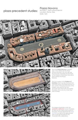
This is the Piazza Navona in present day. In the center are the three famous fountains. You can also see the structures resemble the full shape of the Stadium of Domitian that was in place before the Piazza Navona.
apple maps + jeanclaudegolvin.com
apple maps
This is an overlay of the Stadium of Domitian which was the structure that was built over by the Piazza Navona. In fact, some of the base structure of the stadium was used for the new structures that were built surrounding the plaza. This is why as a mass they look so similar.
This diagram illustrates in red, the pedestrian distribution across the plaza as well was the various entry points to the plaza. The blue illustrates the three fountains as well as the approximate area would get flooded for the Pamphilj family celebrations.
ohiostate.pressbooks.pub
This is the top half of the map of Nolli’s Map of Rome. Nolli was an architect and surveyor and this map is so well known because it is said to be the most accurate map of Rome with so much detail it is composed of 12 plates measuring a total of 5.75’ x 6.8’.
teggelaar.com
This is the Church of Sant’Agnese that is just about in the center of the Piazza Navona across from the Fountain of the Four Rivers. Pope Innocent X ordered for a church to be built over the remaining basilica in 1651 and Borromini took over in 1653 to design and construct the church.
tripadvisor.com
This is the Palazzo Pamhilj which was commissioned by Pope Innocent X when we was still a cardinal. The Palazzo was designed by Rainaldi and built in 1644.
annablennow.wordpress.com
This map is a blown up detail site plan of the Piazza Navona that is located in Nolli’s map of Rome. This and the full map is to think about the large scale of the map. Number 608 is the Church of Sant’Agnese, 607 is the Palazzo Pamhilj, and 621 is the Palazzo Braschi.
reddit.com/r/europe
This is the Palazzo Braschi also known as the Museum of Rome. The building was designed by architect Cosimo Morelli in 1790.
istantidibellezza.it
The base material used in the Fontana del Nettuno is portasanta marble, which is a pink marble with white and black stratus like streaks throughout, here is a close-up of the sides of the fountain. The Fontana del Nettuno was designed by Della Porta in 1574 but wasn’t built for 300 years and depicts Neptune with his trident fighting a giant octopus.
istantidibellezza.it
The base material for the Fountain of the Four Rivers is travertine marble, which is a very porous marble both visually and physically. It creates a very textured feel and look to the fountain. The Fountain of the Four Rivers, is the center fountain designed by Bernini and represents the great rivers of the known continents at the time: Nile, Ganges, Danube, Rio de la Plata.
wikiwand.com/en/Fontana_dei_Quattro_Fiumi
The Fontana del Moro also used portasanta marble for the base as you can see the pink tones, and an ancient marble for the sculptures.
The Fontana del Moro is the oldest of the three fountains also designed by Bernini and depicts a marine man fighting a dolphin.
commons.wikimedia.org/wiki/File:Fontana_del_Moro_Roma.jpg
flickr.com/photos/ertraccia
rhomeguesthouse.com/nasoni-romes-unique-drinking-fountains/
These are called Nasones, which are water fountains that are safe to drink. The water is fresh and has no chemicals as it comes straight from the mountains of higher elevation using the complex aqueduct system in Rome. These can be found in the plaza and all over Rome.
Marsha P. Johnson State Park
ver
Site
Eas t Ri
Architect: NY State Parks + NYC LGBTQ Community Location: Brooklyn, New York Date: Summer 2021
Will
iam Brid sburg ge apple maps
apple maps
This aerial view highlights the site outline that will be redesigned into the new Marsha P. Johnson State Park. Overall it shows the context immediately surrounding the site. Below is the intended design for the park in which you can see the new education center, plaza, and art installations. This view also highlights the location along the east river and how it is currently a site that is undergoing new re-development.
marshap.org
Marsha P. Johnson was a prominent gay rights liberation activist and one of the first. She helped to start a large LGBTQ movement with the Stonewall Uprising of 1969. The motive for investigating this project is to relate her life which was a continuous intersection between racism and homophobia and how it reflects onto this new park design.
filmdaily.co/obsessions/remembering-marsha
interviewmagazine.com/culture/stanley-stellar
Marsha was born Malcolm Michaels and she said the “P” in her name stood for “Pay-it-no-Mind.” Marsha did not always dress in very vivid dresses because she was a person without much money and preferred to offer the little money she had to others in more need of it. Marsha’s lack of money is yet another intersection she had to face in life.
flickr.com/photos/nysparks
This is the proposed site plan layout for the entire site at the moment. You can see the program as well. The entry way would be the new gateway entrance, which has access to the new park house + education center. You then walk through the new art gallery space. You could also walk straight through the history walk which will lead you to thee river side. Finally is the large festival plaza space that opens up to the market space with various sidewalks.
flickr.com/photos/nysparks
flickr.com/photos/nysparks
This aerial view also better expresses the design for the top of the festival plaza strip and you can also see the space above it where tents are set up to sell various things.
This here is the new center for education and park house. The goal of these structures are to provide new facilities such as restrooms, park ranger and storage space.
flickr.com/photos/nysparks
The intended design for this long festival plaza strip is meant to reflect Marsha’s expressive style and love for flowers which is where the selection of bright colors and large flower paintings. Another goal for this plaza is to repave the deteriorating concrete as well as to refurnish.
flickr.com/photos/nysparks
This final space of the park is an art installation in which the LGBTQ community of NYC will be consulted on the content and design of the art to be expressed on the walls.
Architect: DROM Location: Chelny, Russia Date: 2019
Kam a Ri ver
Central Square of Naberezhnye Chelny
apple maps
apple maps + d-r-o-m.com/azatlyksquare/
d-r-o-m.com/about/
d-r-o-m.com/azatlyksquare/
DROM is an architecture firm based in Rotterdam, Netherlands. Sofia Koutsenko and Timur Shabaev established the firm with Timur Karimullin joining after. The three partners of the firm all had plenty of experience at other firms as well as teaching prior to DROM, they all worked at OMA also based in Rotterdam with Rem Koolhaus at some point. DROM is a firm with a collective with experience in exhibitions, architecture, and masterplans so they have an interest in productive spaces, new city models, and the materialization of architecture.
This diagram is a breakdown of the different squares that intersect to form the longer city carpet as a whole. The blue features a summer fountain pool repurposed into a skating rink in the winter. The green is the green space in which one can sit in the local vegetation or sit in the amphitheater/ cafe. The red square serves as a marketplace square and has resting spots with mounds/trees that protect from the crosswinds.
d-r-o-m.com/azatlyksquare/
This is a diagram provided by DROM that shows the different spaces designed into this square. Currently two of the three construction phases have been completed which are most of the outdoor public spaces, including the green square, events square, and culture square. The third phase that will be completed summer 2021, includes the four structures on the south side of the site as well as the representational/religious square.
d-r-o-m.com/azatlyksquare/
This is the viewing spiral which is integrated into the promenade that will be at the center of the site at full completion. The promenade components can be seen above and it runs from the end of the events square to the end of city carpet next to the city hall.
d-r-o-m.com/azatlyksquare/
d-r-o-m.com/azatlyksquare/
d-r-o-m.com/azatlyksquare/
d-r-o-m.com/azatlyksquare/
d-r-o-m.com/azatlyksquare/
d-r-o-m.com/azatlyksquare/
d-r-o-m.com/azatlyksquare/
This image features the culture square that is next to the city hall. This can also be seen as a sort of aquatic square because there is a summer fountain pool that was integrated to the existing fountain. The pool will be repurposed in the winters to serve as a skating rink.
This aerial image features the green square which is at the center of the square. This is the largest of the three sections that features the intersection of the viewing spiral from the walkway at the side. The spiral is purely to offer a new perspective of the redeveloped square to the citizens.
This is the intersection in the square where the events and marketplace square meets the green square with the amphitheater being the prominent component at the junction. To the top of the image is the tree canopied promenade that runs along the square.
These images show another intersection that joins the green square with the events square. The amphitheater looks onto the green square while the structure is disguised as a cafe shop looking onto the evens square.