


Kerala State Design Policy intends to provide a guidance framework that primarily focuses on the growth of the design-based economy of the state. It involves strategies to promote innovations and competitiveness and to guide through a design integrated ecosystem that aims at domestic and global market capitalization. Hence the PWD and Tourism sector in Kerala are in need of a design policy that will be an aid to guide, enact, rule activities and other processes necessary to build a better built environment and infrastructure

A Govt. of Kerala Undertaking Kerala Tourism Infrastructure LTD
Kerala Tourism Infrastructure Ltd. (KTIL), established under the Govt. of Kerala, is the agency to promote investment in tourism sector and to accelerate tourism infrastructure development in Kerala. KTIL was incorporated in August 1989.
Kerala is today growing at an amazing pace in tourism, adhering to the principles of indigenousness, environmental friendliness, and community participation. Asia’s most sought- after tourism spot and India’s only super brand, Kerala, renowned all over the world as God’s Own Country’, currently registers remarkable growth rates, substantiating the World Travel and Tourism Council’s forecast that it would see the highest growth rate in the world, i.e., 11.6%, in this decade.
This remarkable growth has also created an infrastructure gap in various tourism amenıties, resulting in a disparity in supply and demand. KTIL is working towards creating various investment, development and partnership models to address this issue and to catalyse growth.
KTIL’s current activities are broadly segmented into PPP Model Projects, RE-NRK Partnership Projects and Govt. Owned Projects.
• Public Private Partnership: KTIL pioneered the Public Private Partnership (PPP) model in tourism infrastructure development in Kerala.
• RE-NRK Partnership: KTIL introduced the Resident Entrepreneur -Non Resident Keralite (RE-NRK) partnership in tourism investments.
• Govt. Owned Projects: KTIL is also engaged in building up fully Government owned projects bolstering the tourism potential of the state like Sarovaram Bio-park at Calicut, Heritage Tourism Circuit in Thalassery, etc.
INDEX
• Introduction
• Kollam A potential model district
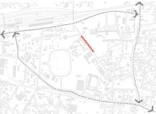
• Introduction to the Precinct
• Kollam, the precinct - Selected loop
• The making of a Model district
• My neighbourhood
• Kollam a living historic context a potential model city
• The colonial history of the proposed loop
• Contextual Analysis - socio-cultural aspects
• Traffic and pedestrianization.
• Area charecter study of the selected Loop
• Structure plan
• interventions deisgn and policy level
• Phase 1: SIte 1 design intervention Site ; SN College road
• Phase 1 : SITE 2 design intervention Sites ; S.N. College Road, Panvel-KochiKanyakumari Highway (NH 66) Junction
• Phase 1: SITE 3 design intervention Site ; QAC ROAD
• Conclusion
• Bibliography
KOLLAM A POTENTIAL MODEL DISTRICT
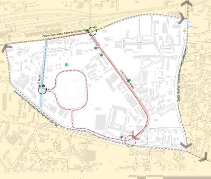
Kollam, a district in Kerala and the seventh largest in the state (Alexander, 2016), can be considered an ideal candidate to be developed as a model city for a multitude of reasons. The unique character of Kollam stems from its historical significance, cultural richness, and strategic economic potential. Its colonial architecture, particularly the remnants from the British era, offers a unique opportunity to blend heritage conservation with modern urban development .Redeveloping key roads such as QAC Road, SN College Road, Chemmanmukku Railway Station Road, and SN College Junction can enhance the connectivity and aesthetic appeal of the city, making it more accessible and attractive to both residents and tourists.


INTRODUCTION TO THE PRECINCT


This area possesses a distinct physical character defined by its boundaries. It is a confined territory with various functional components, making it ideal for model interventions. Originally developed as part of the British cantonment, it remains one of the city’s predominant open spaces. Despite its potential, this area is largely underutilized. Over time, it has been subdivided into smaller land holdings as the city expanded, mostly for institutional purposes.
The intervention area is located in the central region of Kollam district, historically part of the former British colonial territories. This designated precinct encompasses several roads that form an educational hub, characterized by vibrant student activity. However, the inadequately planned infrastructure for pedestrians continues to favor automobile use. Therefore, this area presents a significant opportunity to be transformed into an exemplary model of urban space development.
Kollam Junction Railway Station:
One of the busiest and most important railway stations in Kerala, it serves as a major hub for both passenger and freight traffic. The station is well-connected to major cities across India, making it a critical point for connectivity and transportation. Within the precinct it also serves as a hard physical boundary. (Indian Railways, 2023).
Q.A.C Road
This road is significant for its commercial activities, hosting a variety of shops, businesses, and services, making it a vital artery for local commerce and daily commuting. Additionally, the presence of Lal Bahadur Stadium and various sports-related activities, complemented by the lush green cover of the street, creates a vibrant environment where people regularly gather for sports and recreational events (Kollam Municipal Corporation, 2022)..
Characteristics: This road connects the local Chemmanmukku area to the railway network, enhancing mobility for residents and visitors
Infrastructure: The road is equipped with basic amenities and is moderately trafficked, primarily serving local commuters. (Kollam District Administration, 2023).
Panvel-Kochi-Kanyakumari Highway (NH 66): S.N. College Road:
It is a major route for long-distance travel and freight transportation. Primarily vehicular circulation, this street has minimal pedestrian movement. (National Highways Authority of India, 2023)
Named after the Sree Narayana College, this road is primarily educational and residential. It provides access to several educational institutions, making it a bustling area during the academic year. This route is frequented by students and college /school staff. (Kerala Road Fund Board, 2022).
This road is narrower compared to main thoroughfares. A key local road that connects different residential and commercial areas, providing essential connectivity within the precinct.Also is a major Bus route (Kollam Municipal Corporation, 2022).

MODEL DISTRICT
A model district is an urban area that exemplifies best practices in city planning, development, and management. It serves as an ideal example for others to emulate, demonstrating effective solutions to urban challenges through sustainability, livability, economic vitality, social inclusivity, and efficient governance. (Gehl, 2010; Hall, 2014; UN-Habitat, 2020; European Commission, 2020).
CONCEPT OF LIVEABLE
Reputable scholarship in urban planning and design, including Jane Jacobs, Jan Ghel , Kevien Lynch emphasize the significance of liveable spaces, walkable urban areas as essential to creating livable cities (Jacobs, J., 1961.)
SUSTAINABLE DEVELOPMENT
The sustainable development goals (SDG)’s devised by the United Nations as a part of the sustainable development agenda. It provides a framework for addressing pressing global challenges and achieving them to crate a more equitable world. The Sustainable Development Goals (SDGs) are: 1. No Poverty, 2. Zero Hunger, 3. Good Health and Well-being, 4. Quality Education, 5. Gender Equality, 6. Clean Water and Sanitation, 7. Affordable and Clean Energy, 8. Decent Work and Economic Growth, 9. Industry, Innovation, and Infrastructure, 10. Reduced Inequality, 11. Sustainable Cities and Communities, 12. Responsible Consumption and Production, 13. Climate Action, 14. Life Below Water, 15. Life on Land, 16. Peace, Justice, and Strong Institutions, and 17. Partnerships for the Goals. (United Nations, 2015)

THE MAKING OF A MODEL CITY
Creating a model city or space involves examining it holistically, focusing on factors such as walkability, social dimensions, sustainability, and circulation. Additionally, it considers broader aspects like compactness, connectivity, inclusivity, vibrant nature, and resilience. This approach is exemplified by the Neighborhood Tool, which uses a holistic method to formalize Sustainable Development Goals at a local neighborhood scale by evaluating various parameters as a tool.


The present-day regions of Kollam that were part of the British colonial area can be identified by their historical significance, infrastructure, and architectural legacy from the colonial period. Here are some key areas and landmarks that were influenced by British rule:

COLONIAL HISTORIC CONTEXT OF THE PRECINCT


KOLLAM CITY CENTER:
Kollam Port:
Modernized during the British period to handle increased trade.
Chinnakada:
This central area of Kollam was a hub of commercial activity during the British era and continues to be a major commercial center.
Tangasseri:
An important area that housed former European and British settlements.
Tangasseri Lighthouse: Built by the British in 1902, this lighthouse is a prominent colonial structure. St. Thomas Fort: Originally built by the Portuguese, it was later used by the British.
Eravipuram:
Known for its coastal area and historical relevance, it was part of the administrative expansion during British rule.
Sakthikulangara:
A significant fishing harbor developed during the British period.
COLONIAL ROADS
Many roads laid out during the British period still form the backbone of Kollam’s road network, including segments of the current QAC Road, SN College Road, and roads around Chemmanmukku Railway Station.

COLONIAL HISTORY EDUCATIONAL INSTITU -


Fatima Mata National College:
Established during the British period and continues to be a prominent educational
Founded in 1948, post-independence, but influenced by the educational policies initiated during the British era.

CIRCULATION


USER GROUP ANALYSIS Q.A.C ROAD AND SN COLLEGE ROAD


Legend:
Major road
Primary Road
Tertiary road

Bus stops without bus stands
Bus stands
This map indicates major roads, primary roads, and tertiary roads. Based on the road hierarchy, these roads accommodate different traffic speeds, with major roads catering to higher speeds and slowing down on arterial roads. The map also marks major bus stops, including those without bus stands. There is one bus stand without a corresponding bus stop, which is due to a land ownership issue with the railway. The second spot is along a main road where there is no space for a bus stand. Both of these spots are adequately shaded, and signage can be proposed at these locations
Legend:
-vise useability of spaces
Maximum pedestrian usability period
Moderate pedestrian usability
These street houses various user groups ranging from school students, college students, residents of the railway employees, general adults that come there for sport related activities, parents of college and school students who are transient population, school and college staff and commercial vendors. From the analysis of the spaces it is inferred that start and commencement of institutoal timings
3. Interventions can be proposed to induce controlled activity for gatherings, facilitate use of a T-spot as a place for respite, and provide access to toilet facilities.
11. Encroachment onto pedestrian footpaths must be controlled through the imposition of fines. The current design vocabulary does not contribute to establishing a character for the street.
9. This junction is currently underutilized and cluttered with debris and parked scooters. It can be reactivated into a more pedestrian-friendly space.
Throughout the loop:
Major concerns include parking facilities. Parking could be proposed on identified private land, with vertical parking options facilitated through incentives.
The pavement infrastructure of the pedestrian footpaths is currently broken in many segments. This needs to be surveyed and renovated.


Built use existing
Public and institutional
Religious
Policy Level recomendations
Proposed Cycle loop
Bicycle stands
Design recommendation on building regulations
Street character (design)


Student Street
Sports Street
Design Recommendations
Student street proposed design streach
Junction - Public space
T-Spots

Bus stops - Without bus stand
Boundary of the precinct
SATISFYING
SDG’S
The aspects considered in the formulation of the policy and design framework/proposal satisfy the following SDGs
DESIGN

T-Spots Sports Street Student street S.N. College Road, Panvel-Kochi-Kanyakumari Highway (NH 66) Junction Bus stands /Signage
POLICY LEVEL INTERVENTION
Policy Level recomendations
Proposed Cycle loop
Bicycle stands within institutions
recommendation on building regulations
Street character (design)
Student Street Sports Street
POLICY-LEVEL RECOMMENDATIONS
Proposed Cycle Loop
Introduce a cycle loop to promote sustainable transport and health. Ensure clear maintenance guidelines for long-term success.
Bicycle Stands
Install secure, durable bicycle stands at key locations that complement street aesthetics.
Design Recommendation on Building Regulations
Update building regulations to prioritize sustainable designs that align with the street’s character.
Student Street Character
Design the student street to reflect vibrant student life, with spaces for interaction and creativity.
Sports Street Character
Create a sports street with amenities for various activities, fostering community engagement.
Footpath Renovation Based on a Detailed Survey
Renovate footpaths based on a survey of disrepair and pedestrian flow, incorporating local feedback.
Incentives
Offer incentives for sustainable practices and public space development to attract diverse stakeholders.
Incentives for Private Lands to be Converted into Public Space
Provide incentives to turn private lands into public spaces, ensuring collaborative management for accessibility.
PHASE 1 OF DESIGN INTERVENTION SITES ; SN COLLEGE ROAD
SN College Road
In Phase 1, the primary goal is to establish the street’s character and create a design stretch that aligns with it. The focus is on implementing a cohesive design language for the street, which is predominantly institutional and frequently used by students.
A small section of the street is considered for pedestrianization. The current pedestrian footpath is too narrow, and reclaiming public space is being explored. User analysis reveals that, despite the presence of streetlights, the street is completely unused at night. The design vocabulary is bright and colorful, with enhancements in places of respite and improved legibility through signage and lighting to increase nighttime usability.


EXISTING ROAD SECTION
To better understand the implications of the proposed design, the current street stretch is documented and analyzed through sectional
studies to assess how much space can be utilized for the design. The street is wider at the beginning and gradually narrows toward the SN College junction. Three road sections illustrate this characteristic


EXISTING ROAD SECTION
KEY PLAN
DESIGN CONSIDERATIONS
INSTITUTIONAL CONSIDERATIONS
Entrances to institutions along the road are factored into the design.Assessment of which parcels of are prioritized for the design intervention.
PEDESTRIANIZATION STRATEGY
Proposal to pedestrianize the road by reallocating parking to one side.
Focus on a small section of the road to implement these changes.
PARKING ORGANIZATION
Implementation of designated parking bays on one side of the road for a more organized parking layout to improve efficiency.
OVERALL OBJECTIVES
Balance the needs of pedestrians and vehicles to enhance the usability and safety of the street.
ENFORCEMENT AND REGULATION
Parking regulations will be enforced through fines and rules. Collaboration with the traffic police to ensure compliance and maintain order.

IMAGES - PART KEY PLAN

IMAGES SECTIONS
Image Sections: Analyzing Institutional Entry Points for Student Street Design Proposal
ENTRY ARCH

2.6.1
OVERALL DEISGN
The proposed design incorporates key elements from the neighborhood plan, aligning with the principles of a Compact, Connected, Inclusive, Vibrant, and Resilient City.
In terms of Compact City planning, the design includes infrastructure enhancements for safety, the creation of accessible open public spaces, the development of active streets, and the implementation of sustainable parking policies and reforms.
For a Connected City, the design integrates a clear road hierarchy, enhances walking paths and cycle connectivity, promotes bike parking to encourage cyclability, ensures safety, and provides convenient sidewalks and pathways.
In line with the Inclusive City vision, the design prioritizes pedestrian movement, creates universally accessible streets and open public spaces, and incorporates welcoming places of respite.
The Vibrant City concept is supported by designing active and interesting facades, reinforcing local identity, incorporating historical elements, and fostering vibrancy to stimulate the local economy.
Finally, as part of a Resilient City, the design integrates blue and green infrastructure and emphasizes the use of local materials, ensuring sustainability and environmental resilience
The entrance arch establishes boundary constraints for the proposed street design
JOB INFO KIOSK
Job information kiosks will be placed at the entrances of college institutions to provide students with updates on job opportunities, entrance exam dates, and important educational news. These will be digital screen kiosk signages.
SEATING WITH LANDSACPE
COLOURFUL PAVEMENT
Seating spaces to improve legibility of spaces and also improve place identity In coherence with the street design character, which is intended to be playful and vibrant through the creative use of building elements, the goal is to enhance its attractiveness and serve as a catalyst to encourage people to use the space
PLAY ELEMENTS
Play elements, such as swings, incorporated as a tactical urbanism measure and catalyst to drive pedestrian traffic
SEATING SPACES
NATURALLY SHADED
Places of respite designed with open and partial shade This side of the road has trees and natural shade. Where there isn’t tree cover, the policy recommendation to plant trees along the wall can help with shading and usability during the day
LEGIBILITY OF STREET CHARECTER
Improving
through the use of lights and signs that reinforce the street character and local identity

MATERIAL PALETTE AND THEMATIC ATTRIBUTES

Designated cycle lanes to improve bicyclability and serve as a model for implementation across the entire loop


Material vocabulary that blends with the local material palette, including terracotta, wood, and stone, with terracotta being a predominant feature in the design
SAFETY MEASURES
Safety measures to ensure the protection of pedestrians from other types of traffic

LIGHTING
Signage and street lighting to improve the design quality of the street and usability at night, enhancing safety and functionality for users

PHASE 1 OF DESIGN INTERVENTION SITES ; SN COLLEGE ROAD
MATERIAL PALETTE AND THEMATIC ATTRIBUTES


In coherence with the street design character, which is intended to be playful and vibrant through the creative use of building elements, the goal is to enhance its attractiveness and serve as a catalyst to encourage people to use the space
PLAY ELEMENTS
Play elements, such as swings, incorporated as a tactical urbanism measure and catalyst to drive pedestrian traffic

PHASE 1 OF DESIGN INTERVENTION SITES ; SN COLLEGE ROAD
MATERIAL PALETTE AND THEMATIC ATTRIBUTES

PHASE 1 OF DESIGN INTERVENTION SITES ; S.N. COLLEGE ROAD, PANVEL-KOCHI-KANYAKUMARI HIGHWAY (NH 66) JUNCTION

FEATURES OF DESIGN
ZEBRA CROSSING
Zebra crossings to facilitate better connectivity and pedestrianization at the junction
SITE CONCERNS PAVING
Different paving patterns and textures at the proposed junction to demarcate a better transition of spaces
EXISTING TREE
The existing tree is utilized as a main design element, providing shade and serving as a key landscaping feature
PEDESTRIAN PAVEMENT
The pedestrian pavement is currently broken in several areas. An assessment should be conducted to identify where the pavement is damaged, and renovation should be proposed across the entire loop. This junction has one such broken infrastructure corner that needs to be repaired
SEATING
Built-in seating is proposed here, along with additional lighting design to facilitate activation during the night and organized pedestrian usability and activity during the daytime
-Currently underutilized site
- Debris cluttering
- Disorganized parking
- No night activity
- Pedestrian immobility

EXISTING PHOTOGRAPH

PLAN OF PROPOSED DESIGN
PHASE 1 OF DESIGN
INTERVENTION SITES ; S.N. COLLEGE ROAD, PANVEL-KOCHI-KANYAKUMARI HIGHWAY (NH 66) JUNCTION
MATERIAL PALETTE AND THEMATIC ATTRIBUTES
HARDSCAPING ELEMENTS
NATURAL STONE WALLS
Different paving patterns and textures at the proposed junction to demarcate a better transition of spaces
NATURAL STONE PAVEMENT
SEATING
Built-in seating is proposed here, along with additional lighting design to facilitate activation during the night and organized pedestrian usability and activity during the daytime


SOFT-SCAPING ELEMENTS
EXISTING TREE
The existing tree is utilized as a main design element, providing shade and serving as a key landscaping feature

LIGHTING DESIGN
LIGHTING DESIGN
Lighting activity to improve night activity and legibility.


DAYTIME

PHASE 1 OF DESIGN INTERVENTION SITES ; QAC ROAD
SELECTED AREA CURRENT CONDITION

AREA CHARECTER : SPORTS STREET
LIGHT AND SIGNAGE
The existing tree is utilized as a main design element, providing shade and serving as a key landscaping feature
MIXED USE ACTIVITY
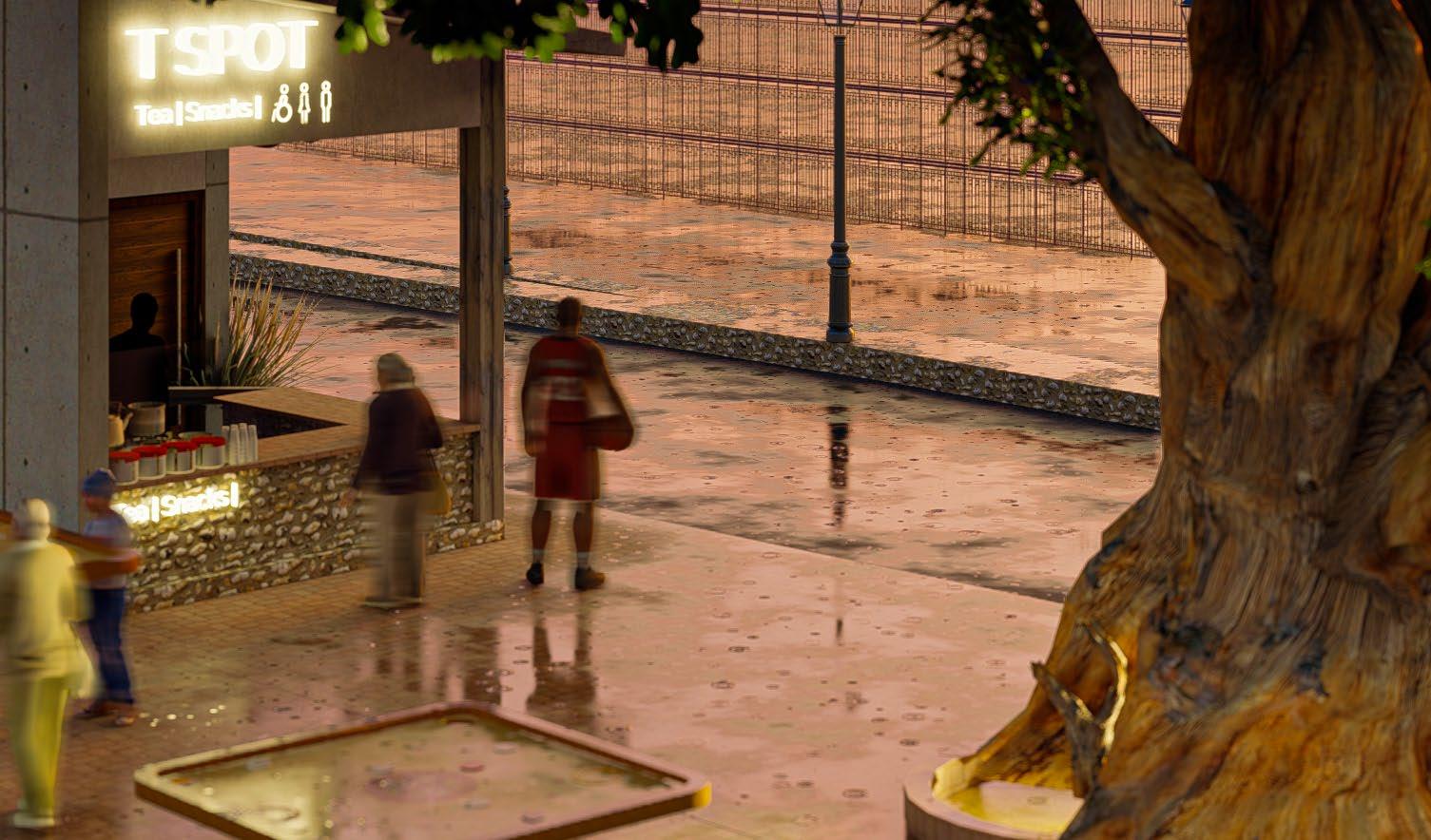
The mixed-use activity is a good point to bring traction and act as a catalyst. The proposed T spots aim to provide respite and also offer clean and usable public facilities to people.
PACKETED SNACKS
GAMEBOARD TABLES KEY PLAN
RESTROOM FACILITY
Restroom facilities are provided for men, women, and also include toilets for the differently-abled, with ramps provided for accessibility. The restrooms are to be well-
WOMAN FRIENDLY SPACE
This space is designed with consideration for the fact that most public spaces do not accommodate people with special needs, such as mothers who require feeding spaces. It provides a dedicated area to meet these needs.

Given its proximity to sports facilities, the design of this space is tailored to its context. Located within the Lal Bahadur Stadium complex, the pavement has been recessed to create additional areas for designated spots. These zones provide resting areas for pedestrians and include amenities such as toilets and breastfeeding spaces, making the area more accommodating for women and accessible for all, including individuals with disabilities. Additionally, the space serves as a meeting point and a hub for providing essential amenities for those participating in sports activities. Informal carom tables and well-planned lighting ensure the space remains functional and inviting even at night. Strategically positioned in the center of QAC Road, this design aims to energize and activate the entire street.

SIGNAGES
THEMATIC LIGHTING DEISGN


TOILET SIGN BOARDS TYPE DESIGN - LIGHTING


MARKED CYCLE TRACK


CONCLUSION
In conclusion, this document presents a strategic vision for transforming Kollam into a model city, aligning with Kerala’s design policy guidelines and the UN Neighborhood Plan. The comprehensive structure plan addresses both micro and macro levels and is divided into Phases 1 and 2. Phase 1 focuses on three key sites within the precinct, integrating UN sustainability goals and addressing essential criteria across several dimensions. This includes enhancing safety infrastructure and creating accessible open spaces for a compact city, developing a coherent road hierarchy and promoting walking and cycling paths for a connected city, and ensuring universal accessibility and welcoming areas for an inclusive city. Additionally, it emphasizes designing vibrant facades and reinforcing local identity while integrating blue and green infrastructure and using local materials to build resilience. Through these strategies, the plan aims to foster a cohesive, dynamic, and sustainable urban environment, celebrating Kollam’s unique heritage and setting a benchmark for future urban development in the region.

Alexander, A.S., 2016. Public participation in planning in India. Newcastle: Cambridge Scholars Publishing.
European Commission, 2020. The Future of Cities: Opportunities, Challenges and the Way Forward. Brussels: European Commission.
Gehl, J., 2010. Cities for People. Washington, DC: Island Press.
Hall, P., 2014. Cities of Tomorrow: An Intellectual History of Urban Planning and Design in the Twentieth Century. 4th ed. Chichester: Wiley-Blackwell.
Indian Railways, 2023. Indian Railways Annual Report 2023. New Delhi: Indian Railways.
Kollam District Administration, 2023. Annual District Development Report. Kollam: Kollam District Administration.
Kollam Municipal Corporation, 2022. Urban Development Report. Kollam: Kollam Municipal Corporation.
Kerala Road Fund Board, 2022. Kerala Road Infrastructure Review 2022. Thiruvananthapuram: Kerala Road Fund Board.
National Highways Authority of India, 2023. National Highways Annual Report 2023. New Delhi: National Highways Authority of India.
Smith, R., 2003. Decline and Renewal in North American Cities. Philadelphia: University of Pennsylvania Press.
UN-Habitat, 2020. World Cities Report 2020: The Value of Sustainable Urbanization. Nairobi: UN-Habitat.
UN-Habitat Urban Lab, 2024. My Neighbourhood Report. Nairobi: United Nations Human Settlements Programme (UN-Habitat).
United Nations, 2015. Transforming our world: the 2030 Agenda for Sustainable Development.
Architectural Digest India, 2024. Mural image adapted from.
Google Earth. Images of site.