KĀPITI COAST
With war clouds gathering in the northern hemisphere, the government of the day invoked the Public Works Act to acquire land for an airport to help serve the big smoke of Wellington.
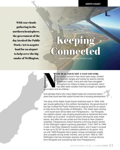
Keeping Connected IMAGES KĀPITI DISTRICTS AERO CLUB
N
EW ZEALAND IS NOT A VAST COUNTRY, but getting around it has never been easy; divided by mountain ranges and rocked by seismic activity, Aotearoa’s roads, rivers and rails have struggled throughout our history to keep us connected, and it has often been aviation that has brought us together as a nation and as whānau. And perhaps that’s why many Kāpiti locals are concerned about plans that could see their airport turned into a housing development. The story of the Kāpiti Coast Airport stretches back to 1939. With war clouds gathering in the northern hemisphere, the government of the day invoked the Public Works Act to acquire land for an airport to help serve the big smoke of Wellington. The Yanks were coming – and would soon all but take over Paraparaumu – but Rongotai, the capital’s airport, was clinging precariously to reclaimed land and not really up to scratch. A second airport serving the area made sense, and after the war ended and the threat to New Zealand subsided, Paraparaumu Airport became a thriving airport central to the Wellington region’s growing population. From 1947 to 1949 it was in fact New Zealand’s busiest airport, and it wasn’t unusual to see up to 20 DC-3s and Lodestars parked on its apron. And up until 1959 Rongotai had a grass runway considered unsafe and unusable during winter months, and so from 1952 to 1957 Wellington had two domestic airports with NAC running Herons from Rongotai and everything else from Paraparaumu. A I R C H AT H A M S . C O . N Z // S U M M E R 2 0 2 0
11


