

ALEXANDRA GRANT REALTOR® alexandra@agrealestategroup.ca (613) 888-8365 60 JOHN STREET, STIRLING Fine Homes & Luxury Properties


Average Transactions per REALTOR #1 Brokerage in the RE/MAX Network


1900+
REALTORS in Ontario A transaction every 21 Minutes
26
Offices in Ontario

14.6


AG Real Estate Group is part of this large brokerage that lives and operates locally. We give you major exposure from the GTA to Ottawa.


#WEMOVEONTARIO
RE/MAX HALLMARK® by the Numbers
Toronto-based, but living and working locally.


Serving Prince Edward County, Belleville, Napanee and surrounding areas.

60 JOHN STREET, STIRLING • 2024 1 REAL ESTATE GROUP
Napanee
Stirling
Belleville
Tyendinaga
Prince Edward County
Tamworth
Bloom eld
Picton
Trenton
Frankford
Roblin Newburgh
Camden East
Bath
Wooler
Consecon
Wellington
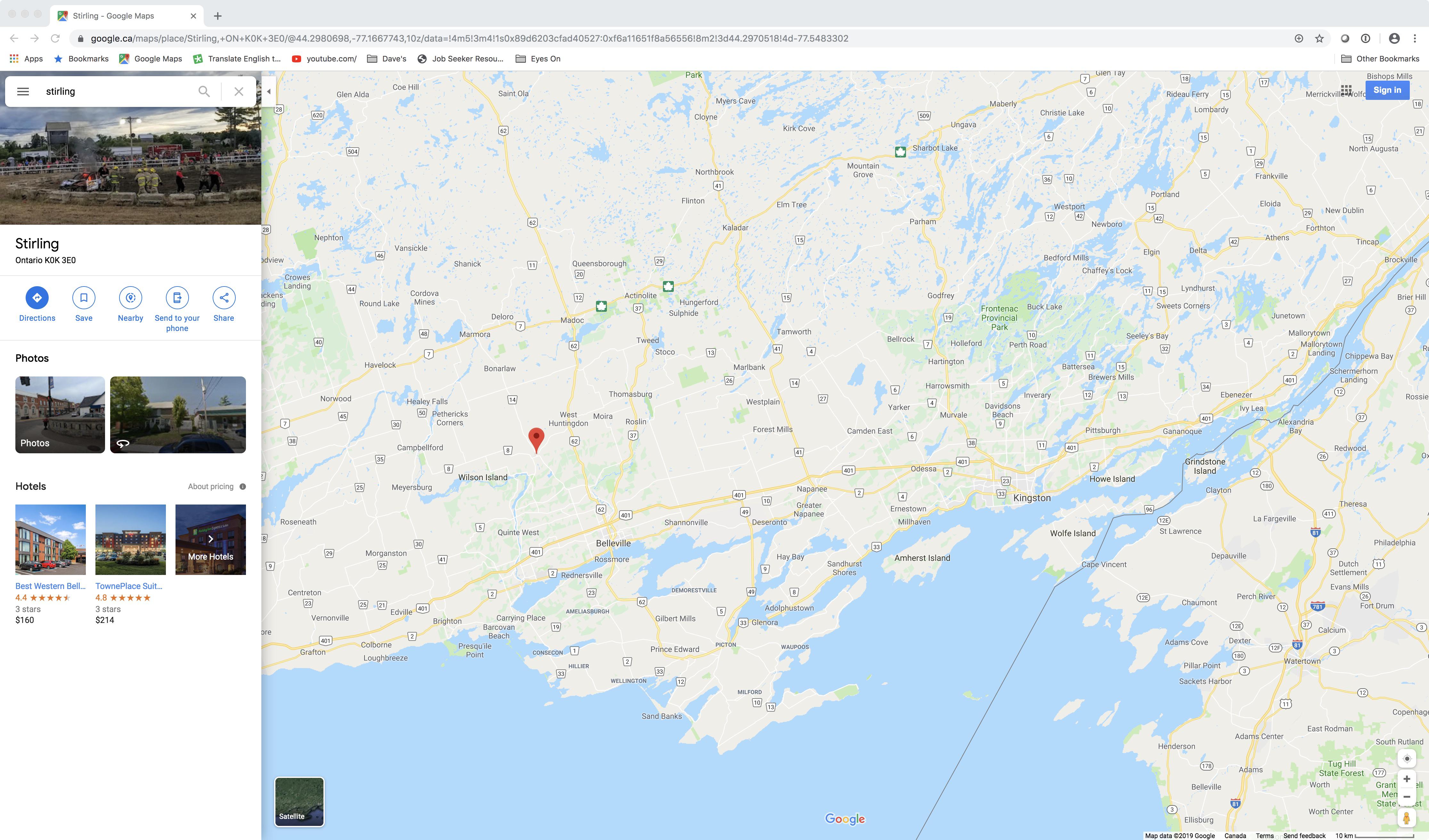
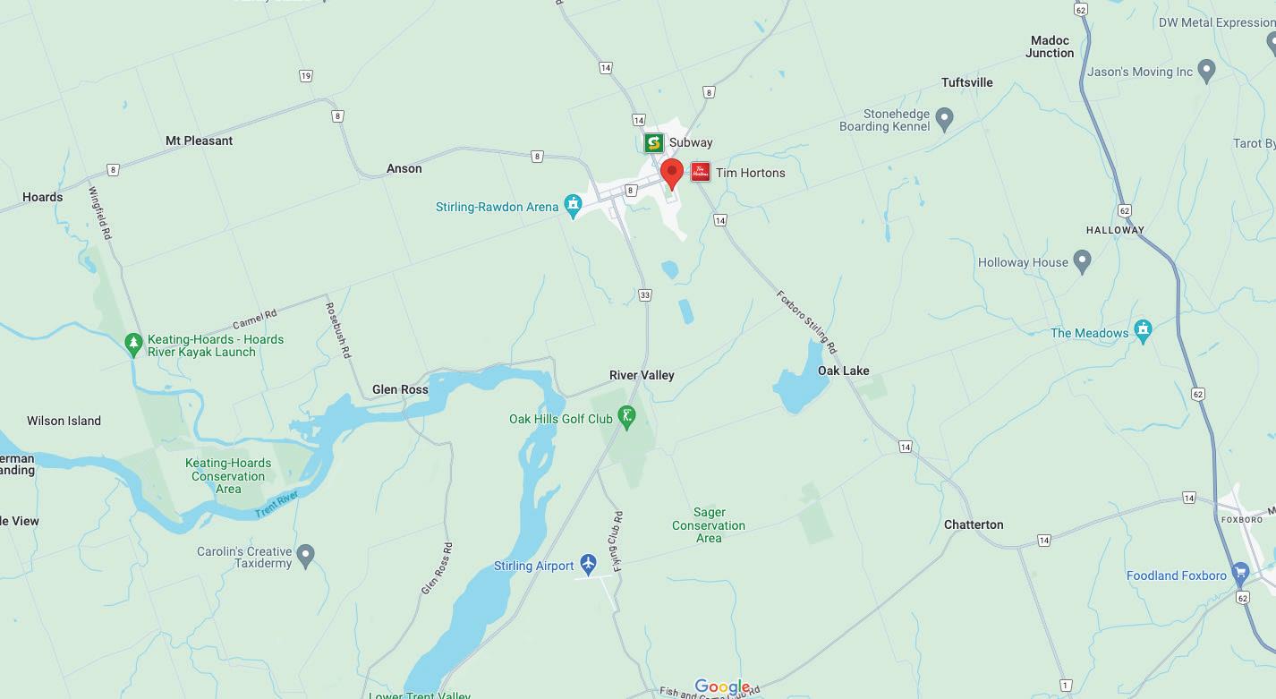
to Property: County Road 14 to John Street Cross St: E Front Street ( County Road 14 )
60 JOHN STREET, STIRLING • 2024 3 REAL ESTATE GROUP Table of Contents Property Information 4 Welcome 5 Specifications 6 - 7 Interior Specifications 8 Living Room 9 Kitchen & Dining Room 10 Primary Bedroom 11 Bedrooms 12 Bathrooms 13 Recreation Room 14 Exterior Specifications 15 Area Attractions 16 - 17 Zoning 18 Survey 18 R1 Zoning 19 - 20 Introducing Alexandra: Your Local Real Estate Expert IBC
hr 4 mins
km)
Kingston
hr 56 mins
km)
Toronto
hrs 28 mins (222 km) to Ottawa
hrs 44 min (378 km) to Montreal
hr 24 mins
km)
USA Border
hr
min
km)
Detroit/Windsor
QUINTE WEST WALLBRIDGE CHATTERTON GLEN ROSS STIRLING STOCKDALE GLEN MILLER MT ZION TRENTON
1
(97.6
to
1
(188
to
2
3
1
(140
to
5
14
(544
to
Directions
60 JOHN ST. STERLING
Property Information
Beds (AG+BG): 2 (2+0)
Baths (F+H): 2 (2 + 0)
SqFt Fin Total: 2,766
AG Fin SqFt Range: 1001 to 1500
AG Fin SF: 1,483/Plans
BG Fin SqFt: 1,283/Plans
Common Interest: Freehold/None
Tax Amt/Yr: $2,956.61/2023
60 JOHN STREET, STIRLING • 2024 4 REAL ESTATE GROUP
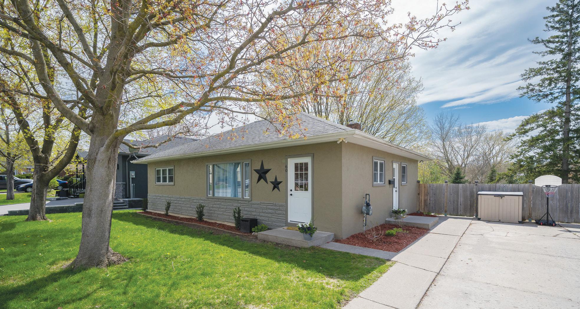
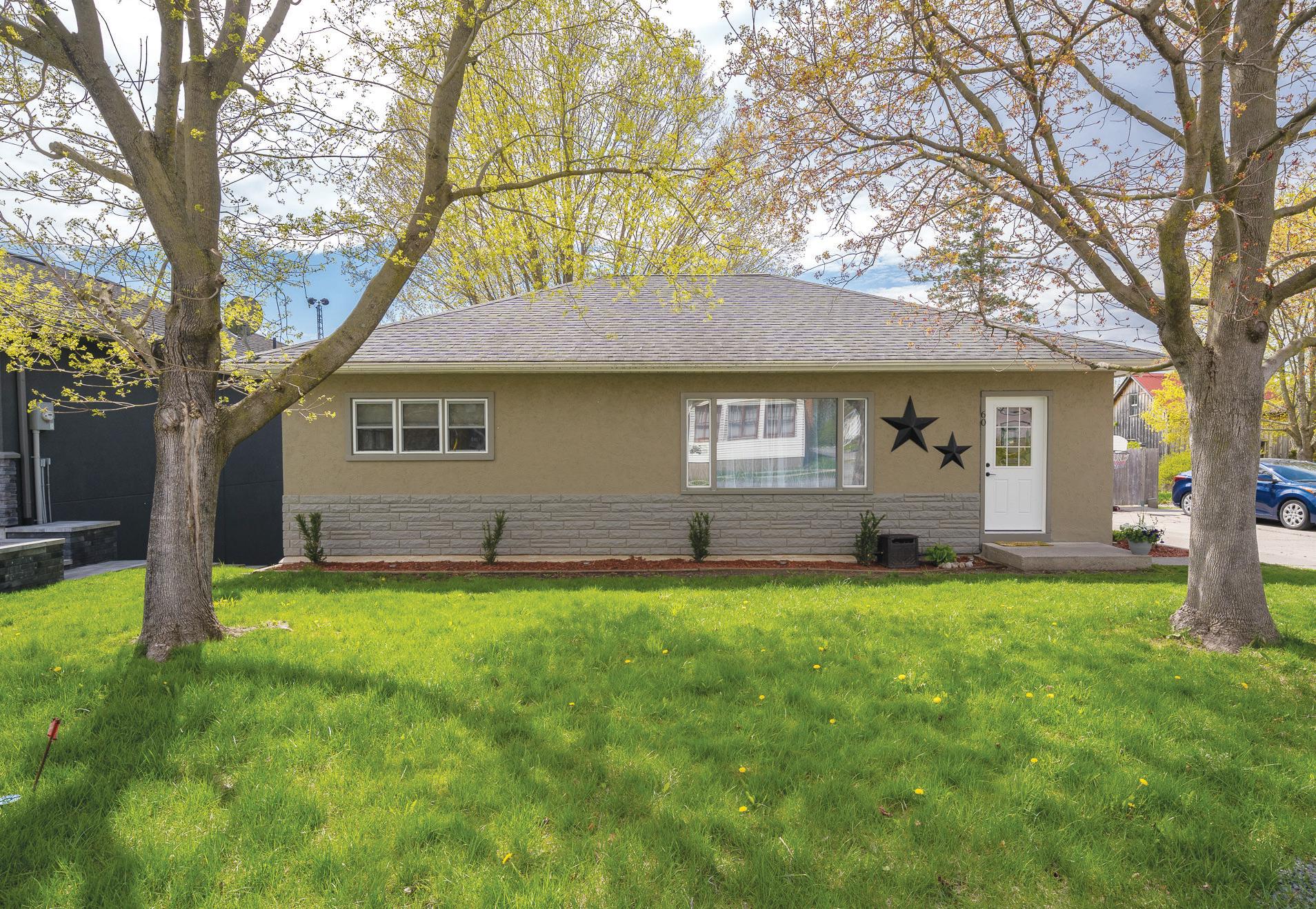
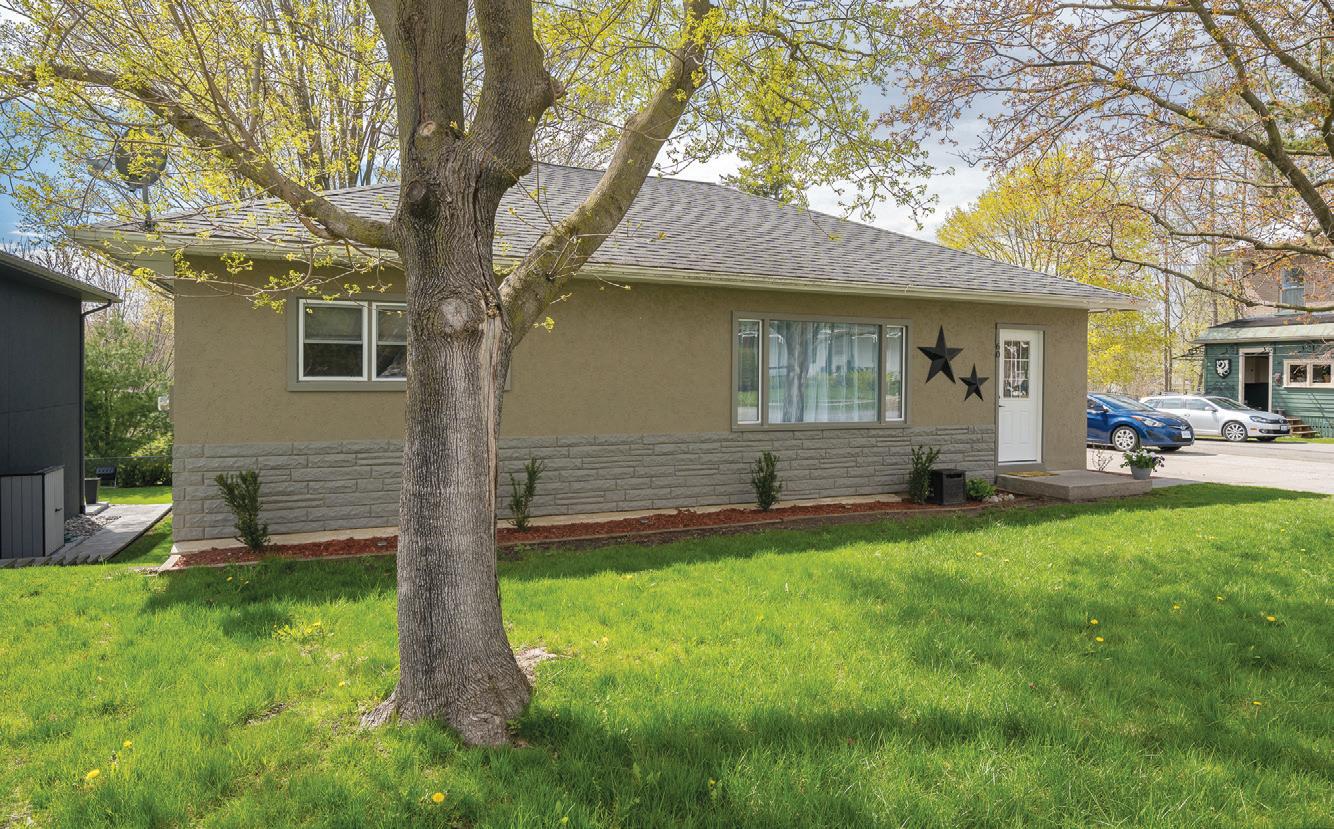
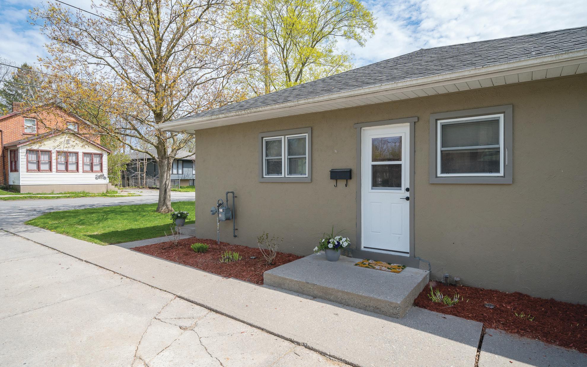
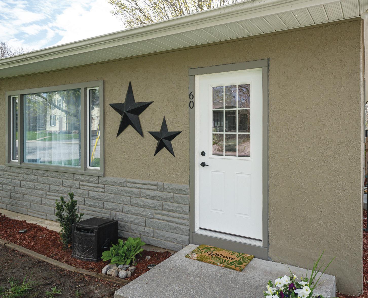
Welcome to 60 John Street, Sterling
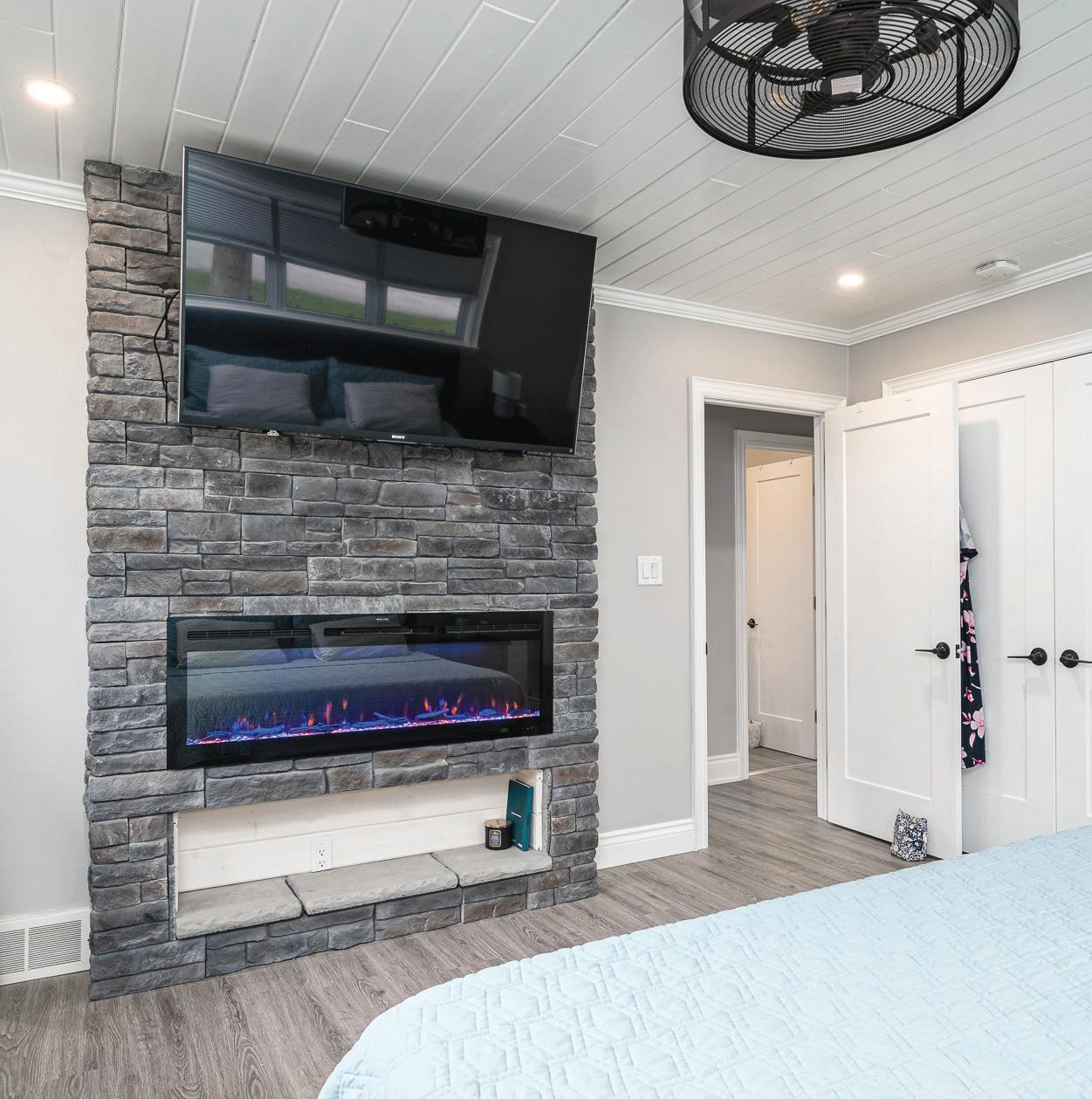
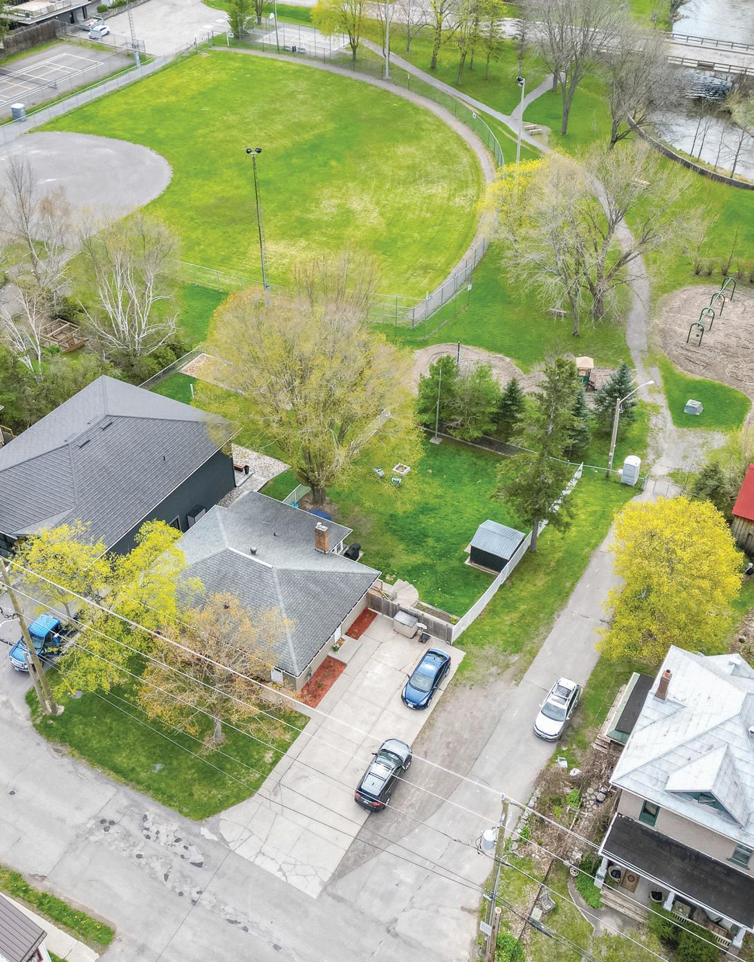
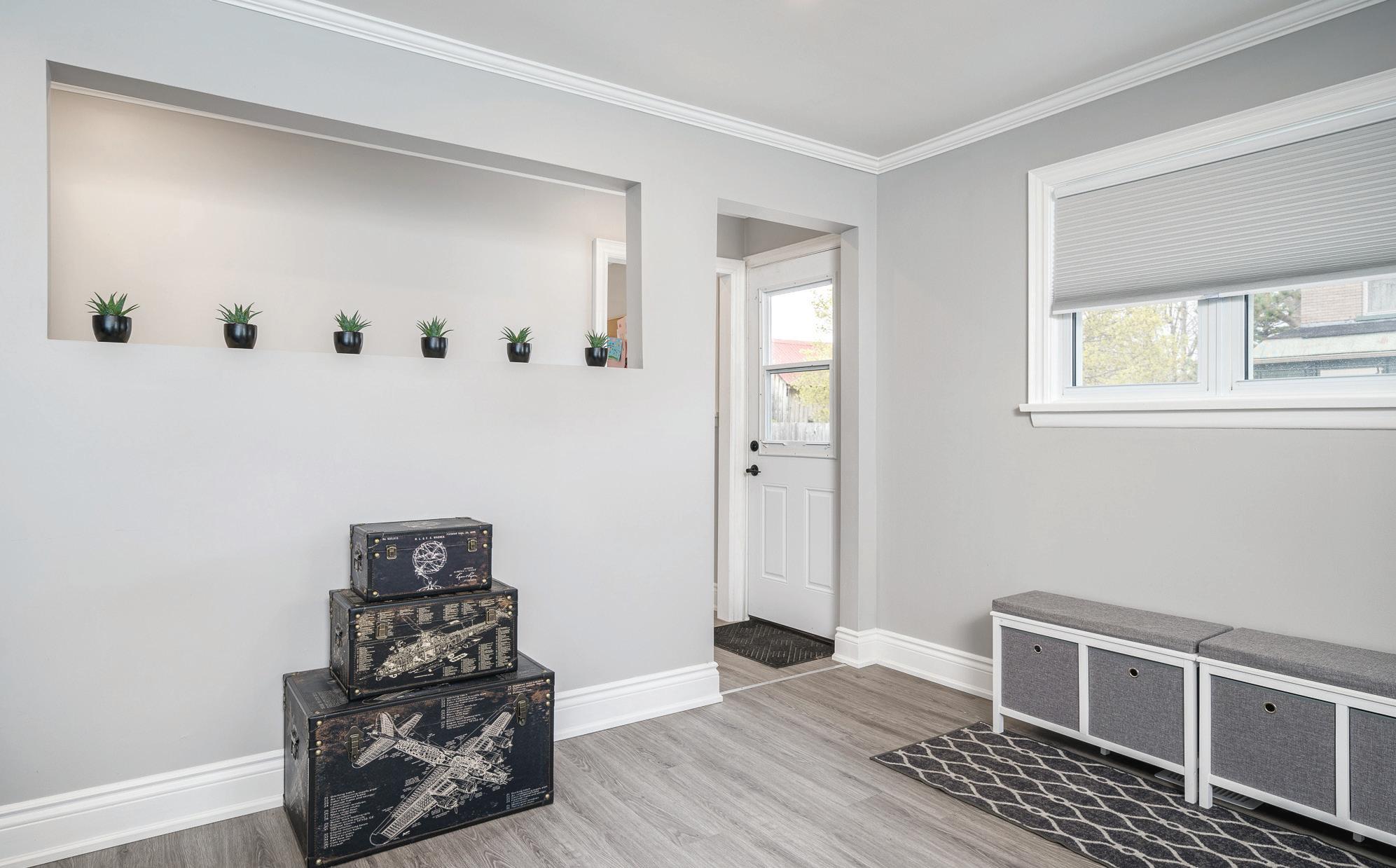
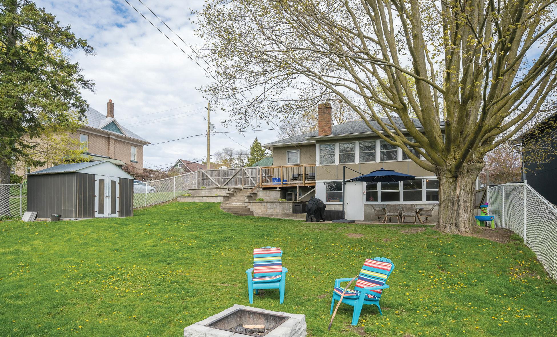
Nestled in the heart of Stirling, this charming 2-bedroom, 1.5-bathroom bungalow exudes warmth and character. Recently renovated, it boasts a fresh newer kitchen, an inviting open-concept layout, and an updated bathroom. A stunning fireplace graces the primary bedroom. The home offers the perfect blend of indoor-outdoor living, with two enclosed sunrooms and a walk-out basement presenting endless possibilities—a recreational haven or potential in-law suite. Step outside, and you’ll find yourself embraced by the tranquility of Henry Street Park, where playful laughter mingles with the soothing sound of a nearby stream. The fully fenced yard, complete with a patio space, beckons for gatherings. With floor plans and a virtual tour at your fingertips, exploring this haven from the comfort of your home is effortless. It’s more than just a house; it’s a sanctuary waiting to be cherished.
Additional Property Information: There is a flood plain which is shown in the EP zone of the property. Hydro for $1731 and Enbridge Gas $1208.17 for 2023.
60 JOHN STREET, STIRLING • 2024 5 REAL ESTATE GROUP
Specifications
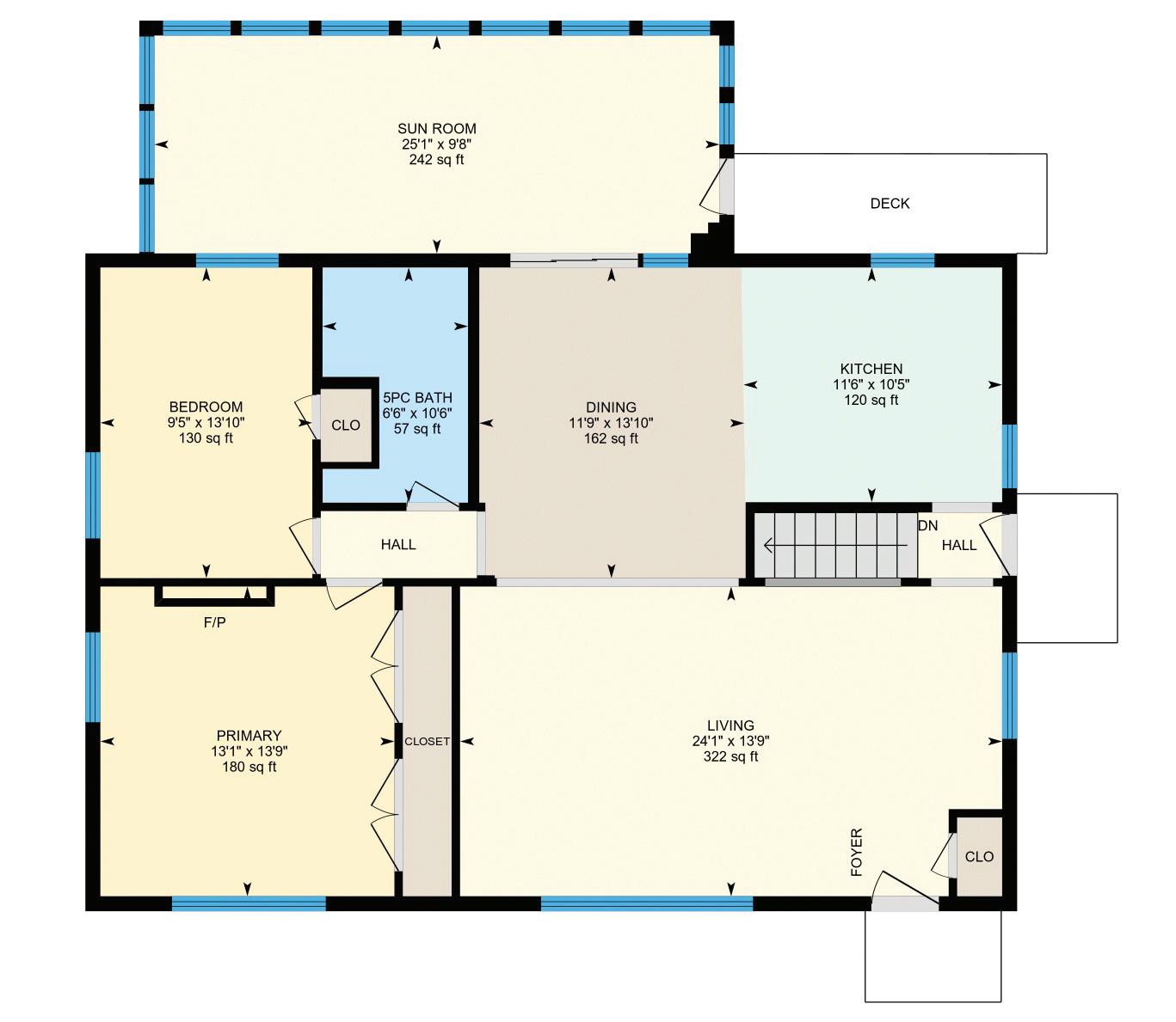
Main Floor –
1379.15 square feet
Size and dimensions are approximate, actual my vary.

60 JOHN STREET, STIRLING • 2024 6 REAL ESTATE GROUP
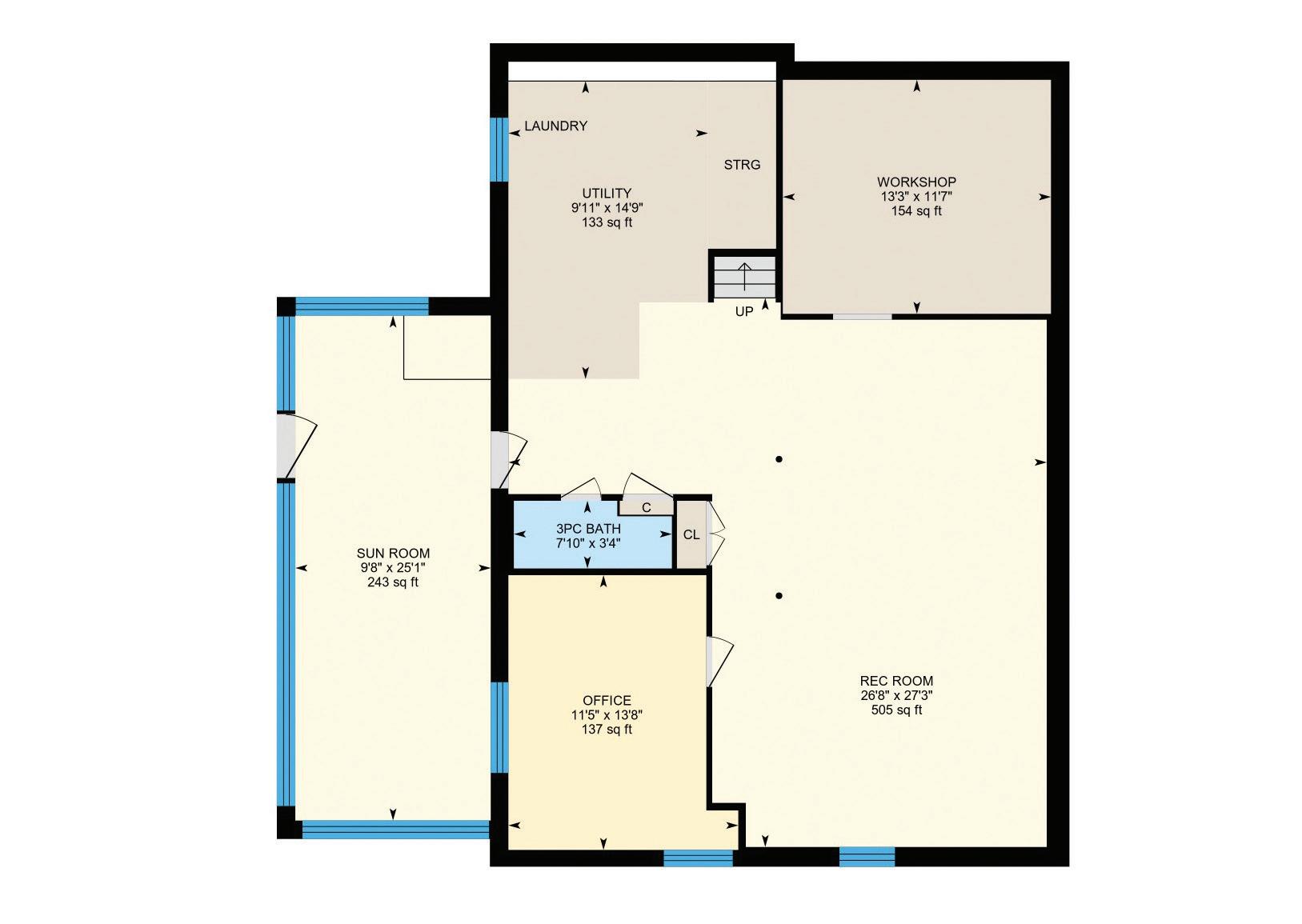
Lower Level – 1283.42 square feet
60 JOHN STREET, STIRLING • 2024 7 REAL ESTATE GROUP
Room Level Dimensions Dimensions (Metric) Room Features Living Room Main 24’ 1” X 23’ 9” 7.34 X 7.24 Dining Room Main 13’ 10” X 11’ 9” 4.22 X 3.58 Walk-out to Sunroom Kitchen Main 11’ 6” X 10’ 5” 3.51 X 3.17 Sunroom Main 25’ 1” X 9’ 8” 7.65 X 2.95 Walkout to Balcony/Deck Bedroom Primary Main 13’ 9” X 13’ 1” 4.19 X 3.99 Double Closets Bedroom Main 13’ 10” X 9’ 5” 4.22 X 2.87 Bathroom Main 10’ 6” X 6’ 6” 3.20 X 1.98 5+ Piece Recreation Room Lower 27’ 3” X 26’ 8” 8.31 X 8.13 Office Lower 13’ 8” X 11’ 5” 4.17 X 3.48 Workshop Lower 13’ 3” X 11’ 7” 4.04 X 3.53 Laundry Lower 14’ 9” X 9’ 11” 4.50 X 3.02 Combined with Utility room Bathroom Lower 7’ 10” X 3’ 4” 2.39 X 1.02 3-Piece Sunroom Lower 25’ 1” X 9’ 8” 7.65 X 2.9 Walk-out to back yard
Specifications
Size
dimensions are approximate, actual
vary.
and
my
Interior Specifications
Interior Feat: Ceiling Fans, Water Heater Owned
Basement: Full Basement
Basement Fin: Fully Finished
Laundry Feat: In Basement
Cooling: Central Air
Heating: Forced Air, Gas
Under Contract: HWT-Gas
Fireplace: 1
FP Stove Op: Yes
Inclusions: Built-in Microwave, Dishwasher, Dryer, Refrigerator, Smoke Detector, Stove, Washer
Legal Desc: LOT 3 W/S JOHN ST PL 95; STIRLING-RAWDON; COUNTY OF HASTINGS
Zoning: R-2/EP
Assess Val/Year: $177,000/2023
PIN: 403310137
ROLL: 122021801013800
60 JOHN STREET, STIRLING • 2024 8 REAL ESTATE GROUP
Living Room
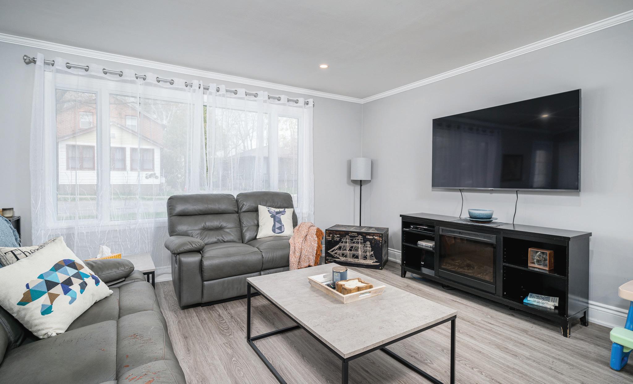

60 JOHN STREET, STIRLING • 2024 9 REAL ESTATE GROUP
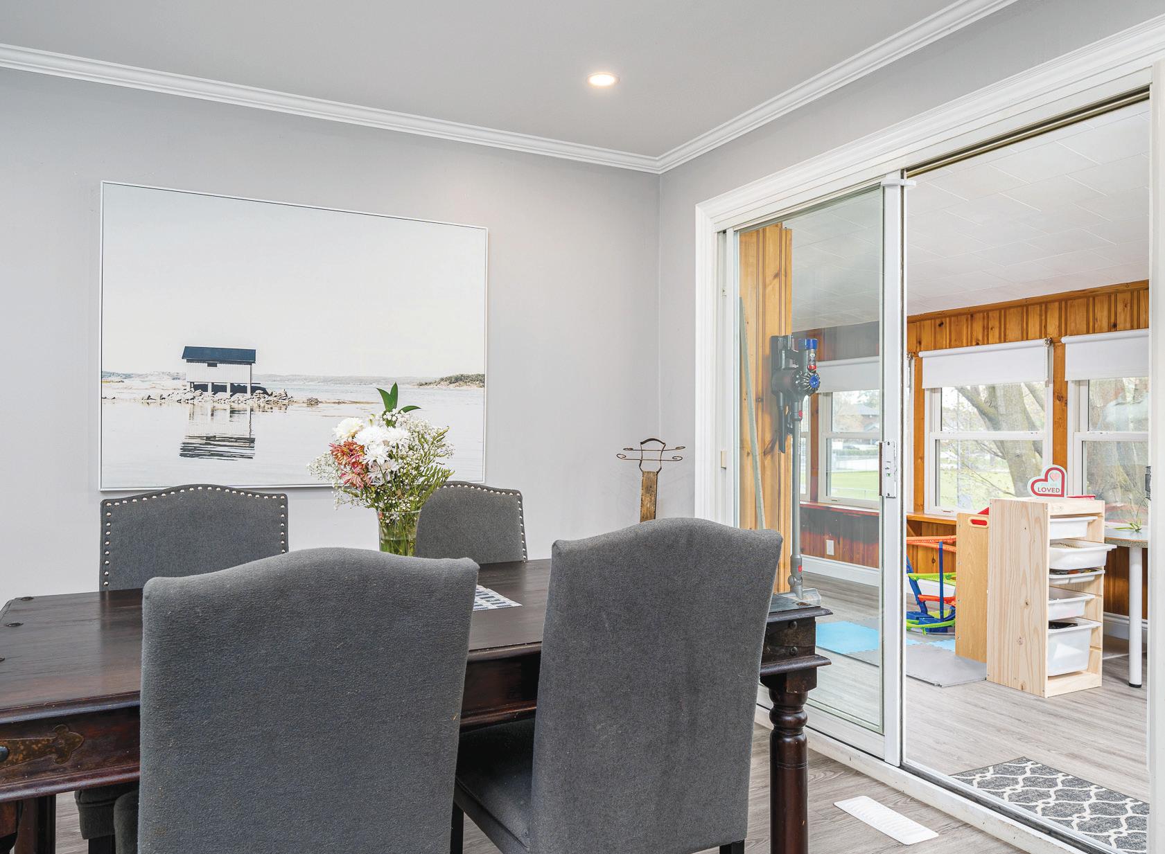
Kitchen & Dining Room
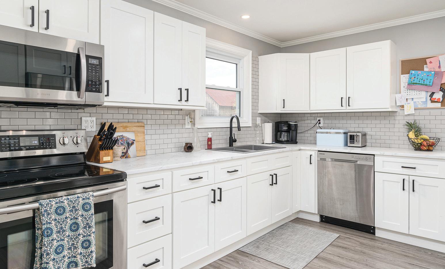
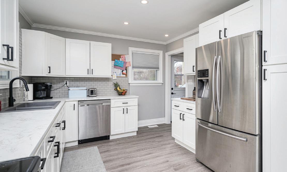
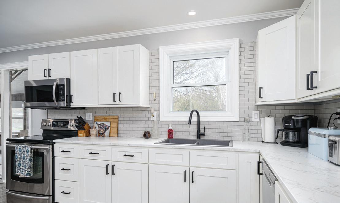

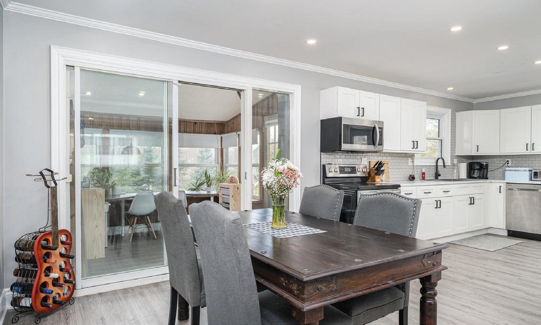
60 JOHN STREET, STIRLING • 2024 10 REAL ESTATE GROUP
Primary Bedroom


60 JOHN STREET, STIRLING • 2024 11 REAL ESTATE GROUP
Bedrooms


60 JOHN STREET, STIRLING • 2024 12 REAL ESTATE GROUP
Bathrooms


60 JOHN STREET, STIRLING • 2024 13 REAL ESTATE GROUP
Sunrooms

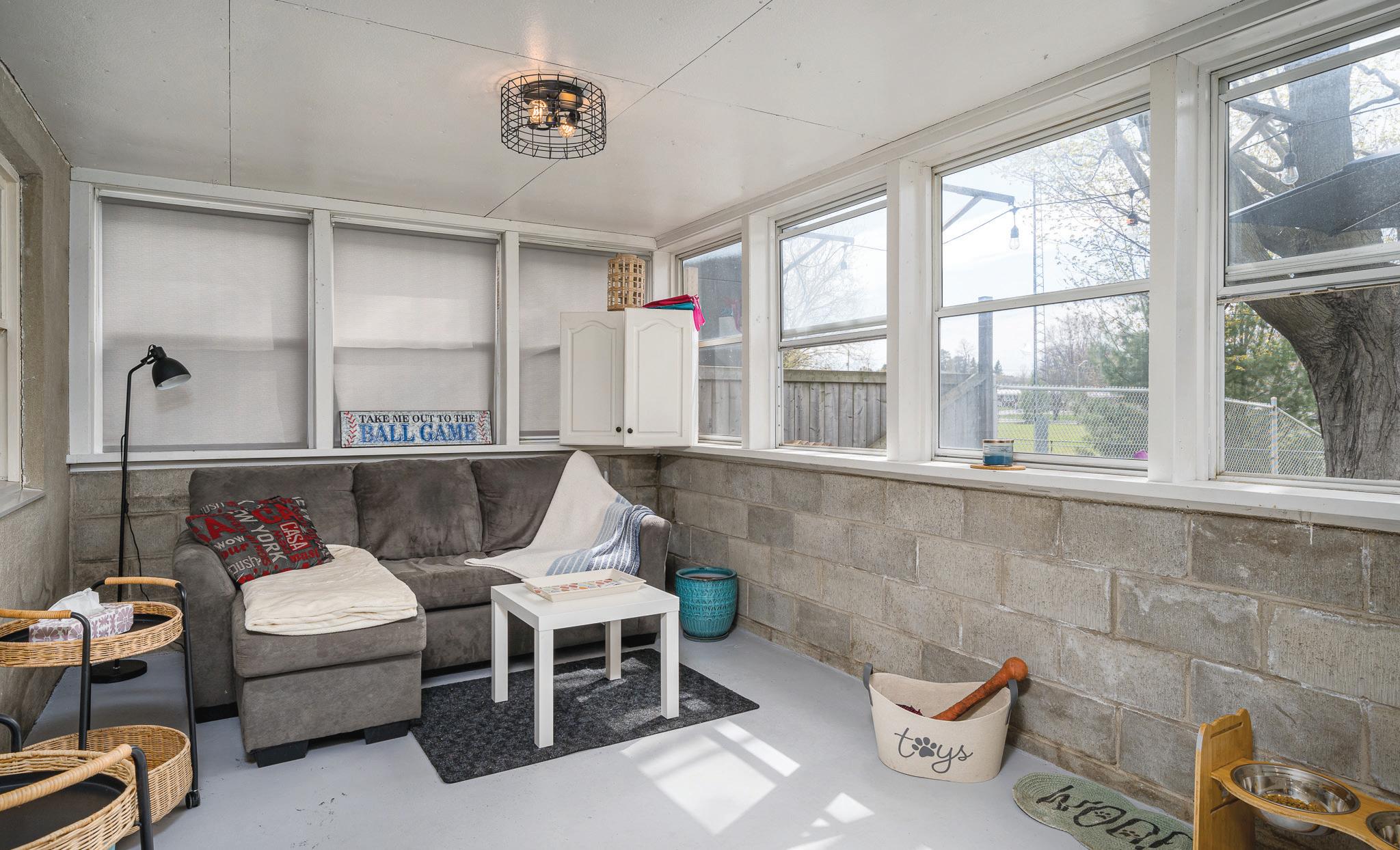
60 JOHN STREET, STIRLING • 2024 14 REAL ESTATE GROUP
Exterior Specifications
Construct. Material: Stone, Stucco (Plaster)
Roof: Asphalt Shingle
Foundation: Concrete Block
Prop Attached: Detached
Year/Desc/Source: 1955//Estimated
Apx Age: 51-99 Years
Property Access: Municipal Road, Paved Road, Year Round Road
Garage & Parking: Private Drive Double Wide //Concrete Driveway
Parking Spaces: 6
Driveway Spaces: 6.0
Services: Cable TV Available, Cell Service, Electricity, Garbage/Sanitary Collection, High Speed
Internet Avail,Recycling Pickup, Street Lights,
Telephone Available
Water Source: Municipal Sewer: Sewer (Municipal)
Acres Range: < 0.5
Lot Front (Ft): 66.00
Lot Depth (Ft): 132.00
Lot Shape: Rectangular
Location: Urban
Area Influences: Park, Place of Worship, Schools, Shopping Nearby
Fronting On: West
Restrictions: Environmentally Protected
Exposure: North, East
School District: Hastings & Prince Edward District
School Board
High School: Bayside
Elementary School: Stirling Public School
60 JOHN STREET, STIRLING • 2024 15 REAL ESTATE GROUP
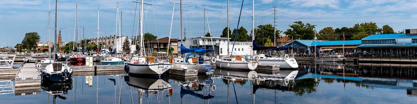
Area Attractions
Stirling-Rawdon is a township located in Hastings County. It was formed on January 1, 1998, through the amalgamation of Rawdon Township with the Village of Stirling. Stirling was named the 2012 Kraft Hockeyville winner, after gaining more than 3.9 million votes.
Stirling also boasts a popular hometown theatre which was opened in 1927, but it was hardly used until the formation of the Stirling Performing Arts Committee in 1982. The theatre is home to yearly pantomimes, musicals, comedy shows, and more.
The Stirling Grand Trunk Railway Station was refurbished in 2008 for the town’s 150th Anniversary celebrations. Situated along the old Grand Junction Railway of Canada Belleville to Peterborough line, this architectural piece of history hosts museum tours and visitor information sessions seasonally between Victoria Day weekend and Labour Day.
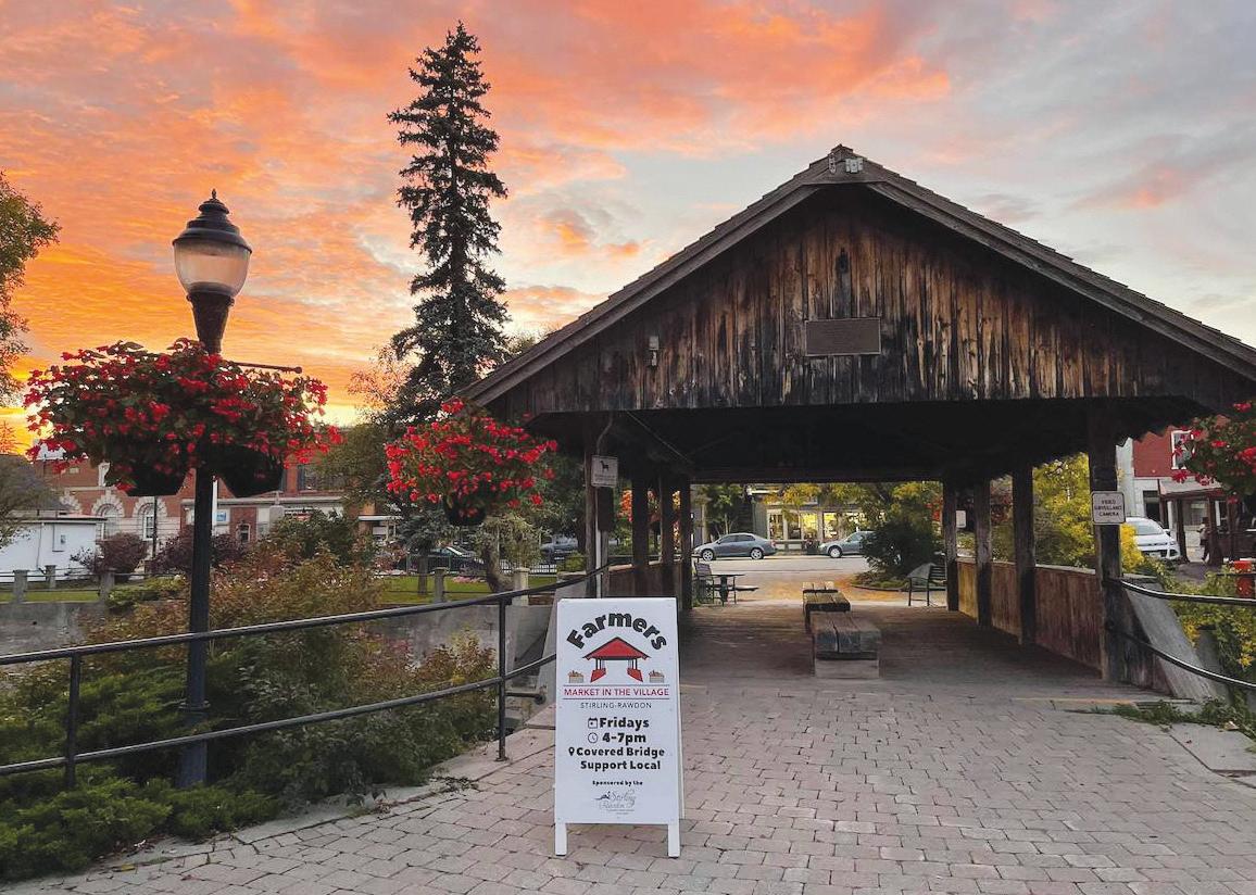
From June until October you can check out the Farmer’s Market at the covered Bridge where you will find an abundance of home grown fruits, vegetables and other home made goods! Plus every holiday season in November you can enjoy the Christmas Market in the village which is always a great time!
Stirling Festival Theatre
Come to Stirling and forget your troubles! Our goal is to make you laugh, relax and have a good time. We offer shows, concerts and all kinds of great events year round. We are also have a lot of incredible space that you can book in either our main auditorium or the Eugene Burrell Hall.

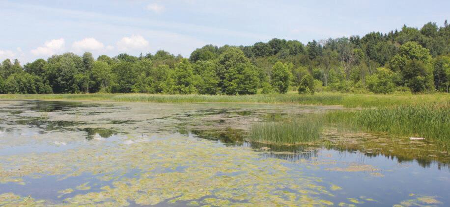
King’s Mill Conservation Area
King’s Mill Conservation Area is situated on Squires Creek at the site of a former grist mill and dam. The property is comprised of wetland, bush, and farmland. The Mill is still standing yet is closed to the public. Many visitors find the area exceptional for photography and painting.
60 JOHN STREET, STIRLING • 2024 16 REAL ESTATE GROUP
Area Attractions

Farmtown Park
Farmtown Park is home of the Hastings County Museum of Agricultural Heritage
The Museum celebrates rural life, and the importance of agriculture and farmers who provide us with food. Farmtown park is open form May 21 until September 30, from 10:00am to 4:00pm with last admission at 3:00pm.
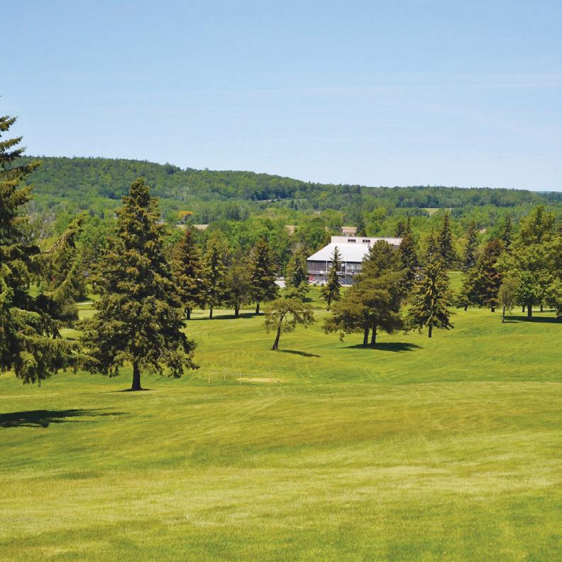
Oak Hills Golf Club
Quinte’s Premier Golf Destination
Stirling Farmers’ Market
A small town farmers’ market with an excellent group of vendors. There’s beef, organic vegetables, flowers, bakers, a cidery, brewers, artisans, and more. All local to Stirling and the area.
Oak Hills Golf Club has 50 plus years of history! Being Quinte’s only 36-hole golf course, Oak Hills Golf Club has a quality design with great layouts and picturesque views. The changing elevations and watercourses mean an interesting day of golf for players of all ages and skill levels. Golfers can join a league and golf weekly, men, women, and juniors alike. We have a golf professional on site to help you improve your game and our practice facility is almost always open! Oak Hills is extremely affordable! With two 18-hole courses, Oak Hills has something to offer for everyone, regardless of your skills level. You can’t beat the quality for the price!
60 JOHN STREET, STIRLING • 2024 17 REAL ESTATE GROUP

60 JOHN STREET, STIRLING • 2024 18 REAL ESTATE GROUP
EP EP R2 R2 R2 EP R2 R2 EP R2 R2-fs R2 EP EP UC UC-fs R2-fs EP EP MR-2 R2-3 MR-2 UC MR-2 R2-3 R2-3 MR-2 MR-2 R2 R1 R2-3 MR-2 MR-2 MR-2 EP R2-3 R1 MR-2 MR-2 R2-3 MR-2 MR-2 MR-2 R2-3 MR-6 MR-2 EP R2 EP EP R2 R2 R2 EP EP EP R2 EP R2 EP R2 R2 EP R2 R2 EP R2 R2 EP EP R2 EP R2 R2 R2 R2 EP R2 R2 EP EP R2 EP R2 R2 R2 R2 R2-3 R2-3 R2-3 R2-3 R2-3 R2 R2-3 R2-3 R2 R2 R2-3 R2-3 MR-7 R2-3-h R2-3-h R2-3 R2 RA R2-3 R1 R1 R1 R1 OS OS R1 R1 122021801015000 122021801012100 122021801000453 122021801018420 122021801018400 122021801000405 Municipal Zoning City of Quinte West, Hastings County, Province of Ontario, Ontario MNR, Esri Canada, Esri, HERE, Garmin, INCREMENT P, USGS, EPA, USDA, AAFC, NRCan Stirling-Rawdon Zoning Marginal Agriculture (MA) Residential First Density (R1) Residential Second Density (R2) Multiple Residential (MR) Open Space (OP) Environmental Protection (EP) Urban Commercial (UC) Urban Industrial (UI) Community Facility (CF) Property Information 5/1/2024, 8:12:40 AM 0 0.04 0.08 0.02 mi 0 0.06 0.12 0.03 km 1:2,257 Public Access Information purposes only and may not be suitable for legal, engineering, or surveying purposes. The County of Hastings disclaims all responsibility for errors, omissions or inaccuracies in this publication. Data supplied under License with OGDE & MPAC.
Zoning
SECTION 13 - R2 - RESIDENTIAL SECOND DENSITY ZONE
13.1 Within a R2 - Residential Second Density Zone, no person shall use any land, erect, alter, enlarge, use, or maintain any building or structure for any use other than as permitted in this section and such use, building or structure shall be in accordance with the regulations contained or referred to in this section.
13.2 PERMITTED USES
1) a single detached dwelling, 2) a semi-detached dwelling,
3) a duplex dwelling,
4) a converted dwelling,
5) a boarding or rooming house,
6) a public park,
7) an accessory building or use to the above uses,
8) a Type ‘A’ and Type ‘B’ home occupation, according to the provisions of Section 5.29 of this By-law.
13.3 ZONE REGULATIONS
a) For a Single Detached Dwelling
Lot Area (Minimum)
464.5 m² (5,000 sq. ft)
Lot Frontage (Minimum) 15 metres (49.2 ft)
Lot Coverage (Minimum) 25 percent
Building Height (Maximum) 11 metres (36.1 ft)
Landscaped Open Space (Minimum) 25 percent
Number of Dwellings Per Lot (Maximum) 1
Gross Floor Area (Minimum) 92.9 m² (1,000 sq. ft)
Minimum Yard Provisions:
- Front or Rear Yard Depth
- Interior Side Yard Width
- Exterior Side Yard Width
7.5 metres (24.6 ft) 2 metres (6.5 ft) 7.5 metres (24.6 ft)
b) For a Semi-Detached Dwelling, A Duplex Dwelling, A Boarding or Rooming House and a Converted Dwelling
Lot Area (Minimum) 800 m² (8,611.4 sq. ft)
Lot Frontage (Minimum) 21 metres (68.9 ft)
Front Yard (Minimum) 10 metres (32.8 ft)
Rear Yard (Minimum) 10 metres (32.8 ft)
Interior Side Yard (Minimum) 3 metres (9.8 ft)
Exterior Side Yard (Minimum) 10 metres (32.8 ft)
Gross Floor Area (Minimum) 180 m² (1,937 sq. ft)
Lot Coverage (Maximum) 30 percent
Building Height (Maximum) 11 metres (36.1 ft)
Off-Street Parking shall be provided in accordance with Section 5.31
60 JOHN STREET, STIRLING • 2024 19 REAL ESTATE GROUP
TOWNSHIP OF STIRLING -RAWDON - COMPREHENSIVE ZONING BY-LAW 97
R-2/EP Zoning
R-2/EP Zoning
c) For a Converted Dwelling and a Boarding or Rooming House
The minimum gross floor area of a one-bedroom dwelling unit shall be 42 m 2 (452.1 ft.2) plus an additional 13 m2 (139.9 ft.2) for each additional bedroom. The minimum lot area per dwelling unit shall be 1400 m 2 (15,070.0 ft.2) (for a converted dwelling).
No addition or enlargement shall be made to the external walls or roof of the dwelling.
No external stairway other than an open fire escape shall be provided. Such dwelling shall be certified by the Chief Building Official to be structurally suitable for such conversion.
The 3-metre strip immediately adjacent to any lot line shall be landscaped. Off-street parking shall be provided in accordance with Section 5.31.
The sewage disposal system shall be inspected and approved by the appropriate authority.
d) For Accessory Buildings Not Attached to The Principal Building
Rear Yard (Minimum)
Interior Side Yard (Minimum)
Exterior Side Yard (Minimum)
2.5 metres (8.2 ft)
2.5 metres (8.2 ft)
7.5 metres (24.6 ft)
Building Height (Maximum) 5 metres (16.41 ft)
13.4 GENERAL PROVISIONS
All special provisions of Section 5 "General Provisions" shall apply, where applicable, to any land, lot, building, structure or use within the R2 - Residential Second Density Zone.
13.5 SPECIAL R2 - RESIDENTIAL SECOND DENSITY ZONES
13.5.1 R2-1 – N.E. Corner of Allan Street and West Front Street
Notwithstanding any provisions of this by -law to the contrary, on lands zoned R2 -1 and shown on Schedule ‘E’ attached, the following special provisions shall apply:
Zone Provisions
1) a service shop for small engines which shall include sale of these items.
All other provisions of this by-law shall apply.
13.5.2 R2-2 – 97 Edward Street
Notwithstanding any other provision of this by -law to the contrary, the following special provisions shall apply:
60 JOHN STREET, STIRLING • 2024 20 REAL ESTATE GROUP
TOWNSHIP OF STIRLING -RAWDON - COMPREHENSIVE ZONING BY-LAW 98
Zone Provisions
1) to recognize a reduced lot area of approximately 0.56 acres 2) to recognize setbacks for an existing residence
All other provisions of this by-law shall apply.
13.5.3
R2-3 – Wells/Ryell Homes Subdivision
Notwithstanding any other provision of this by-law to the contrary the following special provisions shall apply to the lands zoned Special Residential Second Density (R2-3) Zone:
Lot Coverage (Maximum) 35 percent
Front Yard Depth (Minimum) 6 metres (19.6 ft)
Interior Side Yard Width (Minimum) 1.5 metres (4.9 ft)
Exterior Side Yard Width 6 metres (19.6 ft)
All other provisions of this by-law shall apply.
13.5.4 R2-4 – Plan 149, PT Block E RP21R12906 Pts 1 & 2; RP21R9531 Pts 2 & 4 and RP21R13035 Pt 1
Notwithstanding any provisions of this by-law to the contrary, on lands zoned R2 -4, and shown on Schedule ‘E’ attached, the following special provisions shall apply:
Zone Provisions:
1) reduced interior side yard setback from 2m to 1.2m
2) reduced exterior side yard setback from 7.5m to 5m to accommodate wider format houses on lots within the subdivision
All other provisions of this by-law shall apply.
13.5.5 R2-4-h – Plan 149, PT Block E RP21R12096 Pts 1 & 2; RP21R9531 Pts 2 & 4 and RP21R13035 Pt 1, Lots 21 through 25 - DorAnn Homes
Notwithstanding any provisions of this by-law to the contrary, on lands zoned R2 -4-h and shown on Schedule ‘E’ attached, the following special provisions shall apply:
Zone Provisions
1) Holding symbol to remain until conditions as specified by the Lower Trent Conservation in its email dated June 12, 2012 have been satisfied
All other provisions of this by-law shall apply.
60 JOHN STREET, STIRLING • 2024 21 REAL ESTATE GROUP
TOWNSHIP OF STIRLING -RAWDON - COMPREHENSIVE ZONING BY-LAW 99
R-2/EP Zoning
R-2/EP Zoning
13.5.5 R2-5 – 186 Mill Street
Notwithstanding any other provision of this by -law to the contrary, the following special provisions shall apply to the lands zoned Special Residential Second Density (R2-5):
Zone Provisions
1) A deficient interior side yard width of 0.2 feet to an existing garage and proposed addition
2) A deficient interior side yard width of 4 feet to a proposed accessory
All other provisions of this by-law shall apply.
13.5.6 R2-6
– Harvest Glen Subdivision
Notwithstanding any other provision of this by -law to the contrary, the following special provisions shall apply to the lands zoned Special Residential Second Density (R2-6) zones:
a) Permitted Uses:
i) A single Detached Dwelling
b) Zone Regulations:
Lot Area (Minimum)
Front Yard Depth (Minimum)
Interior Side Yard (Minimum) 1.2 metres (3.9 ft)
Exterior Side Yard (Minimum) 5.5 metres (18 ft)
Lot Coverage (Maximum) 35 percent
All other provisions of this by-law shall apply.
13.5.7 R2-7 – Church Street North – Farnsworth
Notwithstanding any other provision of this by -law to the contrary, the following special provisions shall apply to the lands zoned Special Residential Second Density (R2-7) zones:
Zone Provisions:
1) To permit a reduced area and frontage for a semi -detached dwelling unit
All other provisions of this by-law shall apply.
60 JOHN STREET, STIRLING • 2024 22 REAL ESTATE GROUP
TOWNSHIP OF STIRLING -RAWDON - COMPREHENSIVE ZONING BY-LAW 100
12.2
333.0 m² (3,584 ft) Lot Frontage (Minimum)
metres (40 ft)
6 metres (19.6 ft)
4.5 ENVIRONMENTAL PROTECTION LAND USE DESIGNATION
4.5.1 Rationale/Strategy for Development
4.5.1.1
The Environmental Protection (EP) designation comprises natural features and areas within the County that shall be protected for future generations including provincially, regionally and locally significant wetlands, coastal wetlands and associated rivers and streams.
4.5.1.2
The Environmental Protection (EP) designation may also include natural hazard lands that may pose a threat to life and property because of inherent physiographic characteristics such as floodways, erosion hazards, poor drainage/seasonal inundation, organic soil, unstable slopes, unstable bedrock karst formations or other similar physical limitations.
4.5.1.3 Lands designated on Schedule OP-A as follows shall be placed in a corresponding zone in Member Municipality comprehensive zoning by-laws implementing this Plan:
‘EP’ = Locally and regionally significant wetlands, coastal wetlands, floodplains, water bodies, water courses, escarpments and other natural hazard lands as per Section 4.5.1.2
‘EP-W’ = Provincially Significant Wetlands & Provincially Significant Coastal Wetlands
The boundaries of the various Environmental Protection areas are approximate and the intent of this Plan is that precise locations will be delineated in the implementing Zoning By-laws or at the time of the submission of development applications, through the preparation of studies and consultation to the satisfaction of the local Conservation Authority, the MNRF and/or the MOECC and the affected landowners. In the absence of more detailed mapping, the boundaries of the various Environmental Protection designations will be used as a guide in the preparation of the implementing comprehensive zoning by-laws. Modifications of evaluated wetland boundaries must be completed by qualified individuals trained in the Ontario Wetland Evaluation system (OWES) and submitted to the MNRF for review and approval.
4.5.1.4 If land which is designated ‘EP’ or ‘EP-W’ is determined by the appropriate authority to be located outside of environmental protection lands, the development of such land will be reviewed on the basis of the predominant adjoining land use designation and the general intent, goals and objectives of this Plan. An amendment to Schedule OP-A of this Plan shall not be required to make minor modifications to the designation provided that the overall intent of the Plan is maintained.
4.5.1.5 New ‘EP’ or ‘EP-W’ areas shall be added to Schedule OP-A at the time of completing the 5 (or 10) year review of this Plan.
Hastings County Official Plan – December 2017 Prepared by the Hastings County Planning Department 97
4.5.2.5 Buildings, structures or works associated with flood or erosion control, watercourse protection or bank stabilization may be permitted with the written approval of the appropriate authority.
4.5.2.6 Development and site alteration shall not be permitted within or adjacent to lands designated Environmental Protection as required within this Plan. Exceptions may be considered in accordance with the policies of this Plan provided that the ecological function of the natural feature, where it constitutes a natural heritage feauture, has been evaluated and it has been demonstrated that there will be no negative impacts on the natural feature or on its associated ecological functions.
4.5.2.7 Nothing in this section is intended to limit the ability of existing agricultural uses to continue.
4.5.3 Flooding Hazards
4.5.3.1 Flood plains of rivers, streams and small inland lake systems means the area, usually low lands adjoining a watercourse, which has been or may be subject to flooding hazards. The limit of the flooding hazard is generally based on the greater of the flood that would result from the rainfall actually experienced during a major storm such as the Hurricane Hazel storm (1954) or the Timmins storm (1961), the one hundred year flood, and an observed event. Along the shorelines of the Great LakesSt. Lawrence River System and large inland lakes, the limit of the flooding hazard is based on the one hundred year flood level plus an allowance for wave uprush and other water-related hazards.
4.5.3.2 The objectives of this Plan with regard to flood plain management are as follows:
a) Minimize the potential for loss of life and property damage;
b) Reduce the necessity for public and private expenditures for emergency operations, evacuation and restoration of properties and building subject to flooding;
c) Discourage development and site alteration which could affect natural ecosystems, channel capacity and flood flow;
d) Protect and maintain natural channel systems and enhance their biodiversity; and,
e) Minimize water pollution and/or degradation of water quality associated with development activities adjacent to water bodies and floodplains.
4.5.3.3 The following developments shall not be permitted:
a) The application proposes new development within the regulatory floodplain, unless the development by necessity must be located within the regulatory floodplain;
4.5.1.6 Not all streams, waterbodies, environmental features or natural hazard lands have been shown on the Land Use Schedules. The policies of this Plan shall also apply to those streams, waterbodies, environmental features or natural hazard lands not shown on the Land Use Schedules and will be zoned as Environmental Protection in the Member Municipalities’ comprehensive zoning by-laws to the greatest extent possible.
4.5.1.7 The channelization and/or rerouting of a watercourse shall not be permitted unless it will result in an improvement of the natural functions of the watercourse and meet all other legislative requirements including the Federal Fisheries Act and the regulations and requirements of the MNRF or the applicable conservation authority.
4.5.1.8 The County and its Member Municipalities support the efforts of the Hastings County Land Trust in working with private landowners to ensure preservation of environmentally important or significant natural lands and areas.
4.5.1.9 The voluntary use of conservation easements by landowners to protect environmentally significant areas in perpetuity is encouraged by this Plan.
4.5.2 Permitted Uses
4.5.2.1 The uses permitted on lands designated ‘EP’ or ‘EP-W’ are limited to existing agricultural uses, managed forestry, conservation uses which improve the ecological functions of the natural features, wildlife management, uses of a scientific or educational nature and appropriate passive recreational uses that will not have a negative impact on the natural features Active outdoor recreational uses such as golf courses, golf driving ranges and paint ball activities shall be prohibited.
4.5.2.2 Notwithstanding Part A – Section 4.5.2.1 above, other uses of land may be permitted in accordance with other detailed policies of this Plan.
4.5.2.3 The erection of new buildings or structures or the removal or placing of fill in areas designated “Environmental Protection” shall not be permitted without the prior approval of the appropriate authority, except as permitted in Part A - Section 4.5.2.5 below.
4.5.2.4 For the purpose of this designation, development or site alterations are defined as the creation of a new lot, a change in land use, or the construction of buildings and structures requiring approval under the Planning Act and activities such as fill, grading and excavation that would change the landform and natural vegetative characteristics of the site.
b) The application proposes to create a new lot that has insufficient space to accommodate a suitable/appropriate development envelope outside of the regulatory floodplain;
c) The application proposes a change in land use that would increase the risk to life by increasing the use and/or occupancy levels within a regulatory floodplain;
d) The proposed development is unable to meet safe access standards, regardless of whether the lands subject to the planning application are located outside of the regulatory floodplain; or
e) The subject lands are within the regulatory floodplain and the proposal is for an institutional use, essential emergency service or proposes the storage of hazardous substances.
4.5.3.4 The following developments shall be permitted:
a) The application is within the flood fringe of an approved two-zone area or Special Policy Area identified within this Plan and can be flood-proofed in accordance with the local conservation authority or MNRF flood proofing standards;
b) The development replaces an existing structure within the regulatory floodplain on an existing lot of record and all of the following conditions can be met:
i. New hazards will not be created and existing hazards are not aggravated; and,
ii. There are no reasonable alternatives for locating the development entirely outside of the regulatory floodplain, other setback requirements have been minimized, the surface area occupied by the development has been consolidated, the placement of fill, if any will be minimized and any loss of floodplain storage compensated for.
iii. The development can be flood-proofed in accordance with the local conservation authority or MNRF; and
iv. No expansion of the structure shall occur, with the possible exception of a minor addition subject to approval by the applicable local conservation authority.
4.5.3.5 Flood plain and flood line mapping have been completed for portions of the County (see Schedules USP –A.1 – A.6 of Part B – The Urban Communities Secondary Plan). Where Engineered Flood Plain and Flood Line mapping is approved by the local conservation authority and the necessary regulations have been adopted by the appropriate authority(ies), the following requirements shall apply:
a) Flood plain and flood line mapping may be used to prepare local zoning bylaws. All lands within the engineered flood plain are deemed to be designated “Environmental Protection” and shall be appropriately zoned in local by-laws.
Hastings County Official Plan – December 2017 Prepared by the Hastings County Planning Department 100
60 JOHN STREET, STIRLING • 2024 23 REAL ESTATE GROUP
R-2/EP Zoning
99
Hastings County Official Plan – December 2017 Prepared by the Hastings County Planning Department
Hastings County Official Plan – December 2017 Prepared by the Hastings County Planning Department 98
R-2/EP Zoning
b) Where a major alteration is necessary to overcome the hazards within engineered flood lines, an amendment to this Plan shall be required.
c) An amendment to this Plan shall not be required for minor filling within the floodplain, provided the appropriate authority(ies) approve(s) of such alteration.
d) In the absence of detailed flood line mapping, the boundaries of the lands designated as “Environmental Protection” on the Land Use Schedules shall be used as guides for the preparation of the zoning by-law provisions which shall implement the policies of this section. An amendment to this Plan shall not be required for changes to the “Environmental Protection” boundaries deemed to be suitable by a member municipal Council after consultation with the appropriate authority. Where such changes are made, the appropriate abutting land use designation shall apply and the zoning by-law shall be amended accordingly.
e) New development and site alteration, including sewage systems, open or enclosed patios or decks attached to a main dwelling and swimming pools shall be setback a minimum of 30 metres from the high water mark intermittent watercourse or outside the regulatory flood elevation of lakes, rivers, streams or creeks, whichever is greater. Development shall generally be directed to areas at least 15 metres from the regulatory flood plain of the Bay of Quinte or its wave uprush area, if applicable. The setbacks outlined above may be reduced, if it is demonstrated to be good planning, in accordance with a minor variance to the implementing zoning by-law and supported by the written approval of the appropriate authority.
f) The County shall encourage the Member Municipalities to use a one-zone approach to flood plain management. The creation of new lots in the flood plain shall not be permitted. Redevelopment on existing lots within the flood plain shall not be permitted without the approval of the local conservation authority or County peer review agent, as the case may be. Filling and/or redevelopment within these areas may require a Development, Interference with Wetlands and Alterations of Shorelines and Watercourses Permit from the local conservation authority or the local municipality that administers related by-laws. A one-zone approach generally prohibits new development in the floodplain area, except where the structures are intended for flood or erosion control or are otherwise required by the County, local municipality or other public agency and meet the requirements of the local municipality and appropriate authority(ies).
4.5.3.6 Notwithstanding 4.5.3.5 above, the County recognizes that there are portions of flood plains which could potentially be safely developed with no adverse impacts. In these flood plain areas, as identified by the appropriate authority, a two-zone approach to flood plain management shall be encouraged. A two-zone approach to floodplain management requires the identification of a floodway and flood fringe zone. New development in the floodway zone is to be prohibited or restricted to structures intended for flood or erosion control, or which are otherwise required by the County, local municipality or other public agency, and meet the requirements of the local municipality and other appropriate authority(ies). New development in the
Hastings County Official Plan – December 2017
Prepared by the Hastings County Planning Department 101
4.5.4 Locally and Provincially Significant Wetlands ‘EP-W’
4.5.4.1 Wetlands provide essential habitat including food, space and shelter for a variety of freshwater fish, waterfowl, mammals, amphibians and reptiles. A proportionately high number of species at risk rely on wetlands and one-third of all threatened and endangered species in North America depend on wetlands. Wetlands are natural filters that improve water quality, control floods and recharge groundwater. Wetlands also provide opportunities for sustainable forestry, recreation, tourism and appreciation of nature in general.
4.5.4.2 Wetland areas designated Environmental Protection and identified with the symbol ‘EP-W’ on the Land Use Schedule 'OP-A' delineate wetlands and/or coastal wetlands, including the Lower Salmon River Wetland in Tyendinaga Township, that have been evaluated as provincially significant wetlands in accordance with the Provincial Policy Statement. Those wetland areas designated Environmental Protection without ‘W’ symbols delineate locally or regionally significant wetlands and/or coastal wetlands
4.5.4.3 Locally, regionally and Provincially Significant Wetlands shall be zoned and protected by Member Municipalities with equivalent EP and EP-W Zones that prohibits new development and/or site alteration within subject comprehensive zoning by-laws.
4.5.4.4 Policies in this Plan applicable to Provincially Significant Wetlands (PSWs) shall apply to any wetland that is subsequently evaluated and determined by the MNRF to be a PSW. The County may update Schedule OP-A to reflect the new PSW’s with an EP-W land use designation without an amendment to the Official Plan. Member Municipalities may likewise zone these wetlands EP-PSW (or similar name) within their comprehensive zoning by-laws.
4.5.4.5 The objectives with regard to wetland management are as follows:
a) Ensure the protection and conservation of all wetlands;
b) Ensure that the ecological and hydrological functions of all wetlands are protected, maintained and enhanced where possible;
c) Ensure the appropriate studies have been undertaken which demonstrate no negative impacts on or loss of a wetland feature or function prior to the granting of planning approvals such as consents or zoning by-law amendments;
d) Implement the findings and recommendations of the approved studies in Section c) above through a subdivision agreement, development agreement for a consent or site plan agreement, as appropriate; and,
e) Implement appropriate zoning restrictions and regulations for wetlands and adjacent lands on which future development could impact the wetland.
flood fringe zone may be permitted subject to requirements for flood-proofing to the regulatory flood level.
4.5.3.7 A two-zone approach to flood plain management will require an amendment to this Plan. The Town of Bancroft has used the two-zone approach as detailed in Part B -
Section 2.6.3 of the Urban Communities Secondary Plan. The criteria to be used by local municipalities to consider and evaluate the feasibility of implementing a twozone concept in flood plain areas shall include, but is not limited to:
a) Flood susceptibility and hydraulic capacity;
b) Physical characteristics and environmental features of the flood plain and adjacent lands;
c) Local need for development;
d) Impact of development in the flood plain and the watershed area;
e) Feasibility of floodproofing;
f) Constraints on the provision of services (i.e. watermains, sewers, drainage works, etc.);
g) Accessibility;
h) Changes in land use; and,
i) Administrative capability (staff availability and expertise for implementation of two-zone concept).
4.5.3.8
Strict application of the “Environmental Protection” policies may not always be appropriate for flood prone areas where development already exists in flood prone locations. In such areas, it may be in the public interest to assume a higher degree of flood risk than would normally be acceptable elsewhere. The concept of a “Special Policy Area” within flood plains may be recognized and controlled development may be permitted, once such areas are designated within this Plan and/or the Urban Communities Secondary Plan and approved by the appropriate authority(ies). Rawdon Creek, in the former Village of Stirling, as detailed within Part B - Section 2.6.5 of the Urban Communities Secondary Plan is subject to a special provision.
a) The designation of “Special Policy Areas” shall be considered for areas of development where a large component of a community's commercial, retail, industrial and residential development is located in the flood plain or floodway. Such a designation requires the approval of the Ministers of Natural Resources and Forestry and Municipal Affairs.
b) Regard shall be given in the implementing zoning by-law to rehabilitation or redevelopment of structures in “Special Policy Areas” in order to sustain community viability when major relocations are not considered feasible.
c) Infilling in “Special Policy Areas” may be permitted subject to the policies of Part B- Section 2.6.5 of the Urban Communities Secondary Plan.
d) “Special Policy Areas” shall be placed in separate classifications in the implementing zoning by-law.
60 JOHN STREET, STIRLING • 2024 24 REAL ESTATE GROUP
Hastings County Official Plan – December 2017 Prepared by the Hastings County Planning Department 103
Hastings County Official Plan – December 2017 Prepared by the Hastings County Planning Department 102
Introducing Alexandra: Your Local Real Estate Expert

Alexandra has deep ties to the rural outskirts of Napanee, where she currently resides. Growing up in this serene environment, she has gained a profound understanding of rural living and cultivated strong connections within the local community. These connections extend not only to Napanee but also to Prince Edward County and the Quinte region.
Alexandra’s achievements in the real estate industry have earned her numerous prestigious awards from RE/MAX®, establishing her as a respected leader in the field.
Beyond her thriving real estate career, Alexandra cherishes her time spent with her family and two children. Her passions include gardening, golfing, and creating culinary delights in the kitchen.
As a dedicated Rotarian, Alexandra is committed to supporting her communities and the businesses that sustain them. She actively contributes by hosting monthly draws to highlight and support local businesses. Additionally, a portion of every sale she completes goes toward supporting the Children’s Miracle Network.
Alexandra prides herself on being open, honest, and transparent. If there’s anything you’d like to learn more about or discuss with her, rest assured she’ll provide you with the information you seek.
Meet Alexandra – your trusted partner in real estate.
ALEXANDRA GRANT REALTOR®
STIRLING-RAWDON
P.O. Box 40
2529 Stirling-Marmora Road
Stirling, Ontario K0K 3E0
Tel: 613-395-3380
Fax: 613-395-0864
LIBRARY
43 West Front St. Stirling, ON K0K 3E0
SCHOOL BOARDS
Hastings and Prince Edward District School Board
156 Ann Street, Belleville, ON K8N 3L3
Toll-Free: 1-800-267-4350
Phone: 613-966-1170
Email: information@hpedsb.on.ca
Stirling-Rawdon offers a number of services for its residents and visitors.
SCHOOLS
Bayside Secondary School 1247 Old Highway 2 Belleville, ON K8R 0B1 613-966-2922
Stirling Public School
107 St. James Street
Stirling, ON K0K 3E0
SEPTIC REPAIR COMPANIES
A1 Plumbing (613) 398-0599
Ace Septic Pumping (613) 707-9741
Joe Mumby and Sons (613) 707-9845
WATER TREATMENT COMPANIES
A1 Plumbing (613) 398-0599
Quinte Water Treatment (613) 394-0448
Ecowater Systems (613) 392-0068
ENGINEERING
Three Hill Engineering (613) 902-0036
JUNK REMOVAL
Mikes Junk Removal (613) 955-0528
RECOMMENDED CONTRACTORS
A&T Concrete Contractors (613) 395-6499
Braithwaite Carpentry & Contracting (613) 217-3368
Martino HVAC (613) 395-1800
Northland Metal Products (613) 395-0333
Rawdon Refrigeration (613) 395-5386
RECOMMENDED ELECTRICIANS
Rutty Electric Inc. (613) 885.6517
Centre Hastings Electrical Services (613) 848-0060

ALEXANDRA GRANT SALES REPRESENTATIVE alexandra@agrealestategroup.ca • (613) 888-8365 RE/MAX Hallmark First Group Ltd Brokerage Let our experience be your guide!
