Sedimentation dynamics of soil particles in sylvopastoral half-moons on restored plateaus in the Ouallam department (Niger)
1Faculty of Agronomy, Abdou Moumouni University of Niamey, B.P. 10960 Niamey, Niger.
2Department of Rural Engineering and Water & Forests, Faculty of Agronomy, Abdou Moumouni University of Niamey, B.P. 10960 Niamey, Niger.

3Department of Soil Sciences, Faculty of Agronomy, Abdou Moumouni University of Niamey, B.P. 10960 Niamey, Niger.
Received: 27 Sep 2022; Received in revised form: 11 Oct 2022; Accepted: 15 Oct 2022; Available online: 20 Oct 2022 ©2022 The Author(s). Published by Infogain Publication. This is an open access article under the CC BY license (https://creativecommons.org/licenses/by/4.0/).
Abstract The present study was conducted on the Tondibiya and Satara plateaus, in the Ouallam department (western Niger). The objective is to study the sedimentation dynamics of soil particles deposited in sylvopastoral half moons of different years (2014, 2016 and 2018). The assessment of sedimentation was done in selected half moons following a survey on transects It involved the determination of the thickness of the sedimented horizon, the measurement of the permeability by the single ring infiltrometer and the granulometric analysis in the laboratory. The results obtained showed that the thickness of the sedimented horizon varies according to age and is 14.15, 17.33 and 19.37 cm in the 3, 5 and 7 year old half moons respectively. Water infiltration was optimised by sedimentation. It was recorded 70 minutes to be constant in the 7 year half moon and 40 minutes in the 3 year half moon. The granulometric analysis of the sedimented particles shows their dominance by sands (77.73%). These different results show that the sylvopastoral half moon is effective in improving the physical parameters of the soil on degraded ferruginous plateaus.
Keywords Restoration, Soil, Sedimentation, Ouallam, West Niger.
I. INTRODUCTION
In Niger in general, and in its western part in particular, natural resources are undergoing degradation due to the combined actions of climate and man (Boni et al., 2016; Abdou et al., 2016). This situation has been accentuated since the droughts of the 1970s and 1980s (Larwanou, 2005). Each year, more than 250,000 ha of arable land are washed away by degradation (GEF IFAD, 2002). The dynamics of degradation are mainly reflected in the significant retreat of natural vegetation formations (tiger bushes and steppes) in favor of developed landscapes and denuded soils (Issoufou et al., 2018). The consequences include a continued decline in agricultural and pastoral production at a time when basic
ISSN: 2456 1878 (Int.
Environ.
needs are increasing. Increasingly, ecosystem services are being disrupted, significantly impacting the socio economic conditions of local populations, especially during periods of climate shocks (Douma, 2016).
In view of the increasing degradation of natural resources, the consequences of which contribute to the development of the phenomenon of desertification (Larwanou, 2005), a dynamic of restoration of degraded lands is developing nowadays. Indeed, to restore degraded lands, techniques of Water and Soil Conservation / Soil Defence and Restoration (CES/DRS) have been commonly carried out in Niger. Based on the typology of the landscape unit to be managed, these different techniques have been designed according to the desired goal. Among these CES/DRS

Moussa Abdou Ousseini
Dan Guimbo Iro
Dan Lamso Nomaou
, Mahamadou Moussa Abdoulaye
techniques, dug structures, including the half moon for silvopastoral purposes, are the most widely used (Douma et al., 2011; Amani et al., 2021). However, apart from the respect of design and management standards, the results of the developed areas depend on the age of the construction, but also vary according to the sites (Vlaar, 1992; Laminou et al., 2020). It therefore appeared necessary to study the impact of the sylvopastoral half moon on the physical conditions of the soil. Thus, the objective of this work is to evaluate the physical parameters of sediments deposited in the half moon on pastoral sites developed in different years.
II. MATERIALS AND METHODS
2.1. Study sites
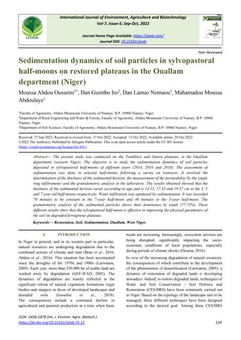
The department of Ouallam in western Niger was the study area (Fig 1). The developed plateaus of Tondibiya and Satara, in the rural communes of Tondikiwindi and Simiri respectively, were the study sites for the present work. The climate is tropical arid, with an average annual rainfall of 250 450 mm (Laminou et al., 2020). The year is characterised by a dry season of 8 to 9 months and a rainy season of 3 to 4 months. The average minimum temperature is around 18° (December January) and the maximum around 45° (March April). This rise in temperature leads to an increase in evapotranspiration, which is around 3000 mm per year, with a minimum of 460 mm in the rainy season and 2460 mm in the dry season (Amadou,2012).
The sylvopastoral half moon, the subject of this study, has the characteristics presented in Table 1. Photo 1 illustrates a half moon.
ISSN: 2456 1878 (Int. J. Environ. Agric. Biotech.) https://dx.doi.org/10.22161/ijeab.75.13
Odunayo et al. International Journal of Environment, Agriculture and Biotechnology,Table 1: Characteristics of a half moon Characteristics of the Half moon sylvopastoral pastoral Values
Diameter (m)
Depth of the trough (m) 0,15 à 0,30
Bead height (m) 0,30 à 0,40
Area (m2
Density per hectare
Photo 1: a: View of an undeveloped site; b: Compartment of a completed half moon
The biological treatment given to the structures when they were installed and the natural regenerative power of the environment have allowed vegetation to return. The sites were constructed in different years starting in 2014. Thus, the study selected the 2014, 2016 and 2018 completion sites. Data collection was carried out in 2020 where the respective ages of these sites are 7; 5 and 3 years.
2.2. Data collection
The data was collected mainly on the particles deposited in the half moon basin. This sedimentation assessment was done along three (3) parallel transects. One transect runs perpendicular to the contour line. On each transect, ten (10) half moons were selected using the "No sounding" method according to formula (1). The number of half moons surveyed per site was thirty (30). The sampling by transects and sampling were chosen to have the representativeness of the structures taking into account the factors influencing the dynamics of sedimentation among which the wind (Abdourhamane, 2011).
N = Total number of DLSP on the transect : ∑Xi
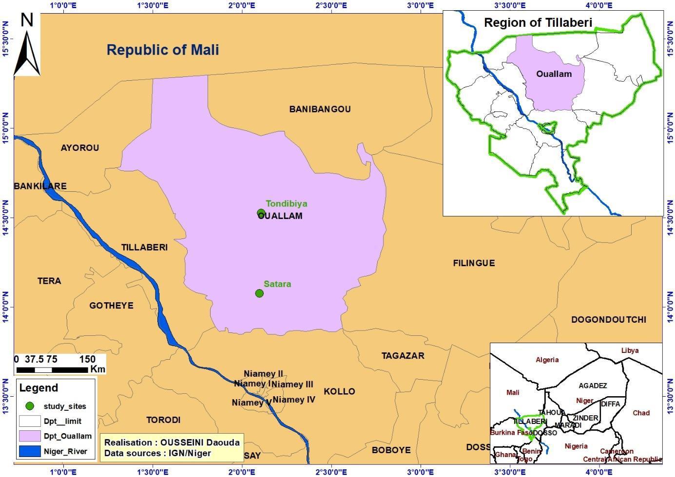
Indeed, the deposition of the particles was studied on three parameters: thickness, water permeability and texture. Fig. 2 shows the data collection points in the half moon
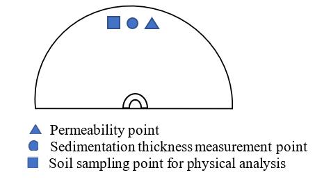
Fig 2: Collection points in the half moon
2.2.1. Thickness of sedimentation
The thickness of the sediment deposited in the half moon basin was measured by opening a cultivation profile (Photo 2). The layer representing the deposited soil

ISSN: 2456 1878 (Int. J. Environ. Agric. Biotech.)
https://dx.doi.org/10.22161/ijeab.75.13
particles was delimited by means of a visual assessment. The thickness was then measured with a ruler.
The thickness of the sediment layer depends on the age of the structure. This led to the evaluation of the sedimentation rate as given by formula (2).

�� ��
Vs : Sedimentation rate (cm/year); E: Measured sedimentation thickness (cm) and A: Age of the structure in years (year)
The evaluation of the thickness of the sedimentation thus makes it possible to assess the volume of soil available to the herbaceous plants for the development of their subterranean part on the one hand, and available to the water for its infiltration and evaporation flows on the other.
2.2.2. Water permeability
The 20 cm diameter single ring infiltrometer was the equipment used to measure water permeability. The activity consisted of installing the infiltrometer and quantifying the infiltrated water depths. The infiltrometer was sunk about 5 cm into the ground to prevent water from leaking onto the ground surface during the test. It is then filled with potable water to a height (H) and allowed to infiltrate for a timed period. At the end of the time, a height (Hf) is obtained from which the infiltrated height (Hi) is obtained by formula (3). The operation is repeated by filling the infiltrometer again to the height H. The activity is thus continued repeatedly until a constant infiltration height is obtained (same Hi value three times in a row). The number of repetitions of the operations during
ISSN: 2456 1878 (Int. J. Environ. Agric. Biotech.)
https://dx.doi.org/10.22161/ijeab.75.13
a test (Table 2), depends on the time taken to obtain Hi. The infiltration rate or infiltration coefficient (Yaméogo et al., 2013) was calculated according to formula(4).
Hi : Infiltrated height in millimeters (mm); H : Initial height in millimeters (mm); Hf : Final height in millimeters (mm)
V: Infiltration speed mm/min; Hi: Infiltrated height in millimeters (mm); t: Time taken in minutes (mn)
Table 2: Duration of the survey sheet operations
The infiltration test was carried out in the pit of the structure and on a bare area without vegetation representing the control (Photo 3). The permeability allows the sedimented soil to be compared to the encrusted control, as insufficient water infiltration into the soil is a key factor in land degradation or fodder production on pastureland
OdunayoPhoto 3: Installation of the infiltrometer on an
of
Photo 4: a: Core measurement, b: Soil sampling

III. RESULTS
textured
The
are
on the site. Table 4 gives the

prior
for
for those of
It
of
the
of
(Fig.
Half-moon
ISSN:
the sedimented soil are greater
The permeability study shows that infiltration and its
Times in minutes
Cuvette Witness
Half-moon of
in minutes
Cuvette Witness
Half
in minutes
Cuvette Witness
OdunayoHalf moon of 3 years
mm/mn
2
1
0
mm/mn
0 0.2 0.4 0.6 0.8
0 5 10 15 20 25 30 40 50 60 70
Times in minutes
Speed in the half-mmon Speed of the witness
Half-moon of 5 years
0 0.1 0.2 0.3
0 5 10 15 20 25 30 40 50 60 70
Times in minutes
Speed in the half-moon Speed of the witness
Half moon of 7 years
0 5 10 15 20 25 30 40 50 60 70 80 90
Times in minutes
Speed in the half-moon Speed of the witness
Fig. 4: Evolution of the water infiltration rate
It can be seen that infiltration has been improved by the half moon. The better infiltration recorded on the 3 year old control site is explained by the fact that the upper soil horizon has more pores than the sedimented layer in the half moon.
ISSN: 2456 1878 (Int. J. Environ. Agric. Biotech.)
https://dx.doi.org/10.22161/ijeab.75.13
Odunayo3.3. Particle size parameters
Table 5 presents the results of the particle size analysis.
Table 5: Soil particle size Halfmoon age (years)
Clay Fine silts Coarse silts Fine sands Mediu m sands Coarse sands sands Clay + Fine silts
Texture
7 3,78 9,13 9,37 26,26 41,78 9,69 77,73 22,28 Sandy silt
5 2,52 15,03 12,87 21,96 36,00 11,61 69,57 30,42 Silty sandy
3 1,01 12,36 11,93 30,37 33,71 10,61 74,69 25,30 Sandy silt
TCD 3,04 12,09 15,36 21,77 33,21 14,52 69,5 30,49 Silty sandy Clay ɸ < 2 µm; Fine silts: 2 < ɸ< 20 µm; Coarse silts 20 < ɸ< 50 µm; Fine sands: 50 < ɸ < 200; Medium sands 200 <ɸ< 500 µm and Coarse sands 500 < ɸ < 2000µm and TCD: Completely degraded control
The granulometric analysis reveals that sands dominate. They represent at least 2/3 of the particles with a dominance of medium sands. It also appears that the texture of the sedimented soil in the basin of the structure tends to be coarse. The 7 year old half moon recorded more sands compared to the 5 and 3 year old half moons.
IV. DISCUSSION
The deposition of particles in the basin has the role of reconstituting the essential functions of soils as a support for species, particularly plant species, as a nutrient bank and as a catalyst for exchange between the edaphic environment and the atmosphere (Ay et al., 2020). The thickness of the sedimentation varies between sites, but the trend shows that it increases with the age of the half moon. It increases from 14.15±1.5 cm in the 3 year old half moon to 19.37±6.04 cm in the 7 year old half moon. Apart from age, factors influencing the deposition of particles in the basin can include wind erosion, crumbling of the bead by raindrops, the texture of the developed soil and the type of development works. In their study in the commune of Simiri (Niger), Laminou et al (2020) found a sedimentation thickness of between 8 and 15 cm in the 3 year old pastoral bench, the structure sharing the same basic principles and functioning with the pastoral half moon. This proves that excavated structures cause sedimentation of particles in their trough.
Depending on the site, the infiltration of water, the height of infiltration, the time from which it becomes constant and the speed of infiltration are different. This difference tends to become apparent as the age of the structure increases. In this sense, the duration from which the infiltration becomes constant is 40 and 70 minutes respectively for the 3 and 7 year old half moon. This is
ISSN: 2456 1878 (Int. J. Environ. Agric. Biotech.) https://dx.doi.org/10.22161/ijeab.75.13
explained by the thickness of the sedimentation which increases with age. The high infiltration rate or infiltration coefficient of the structures is 1.06 mm/min, obtained in the basin of the 3 year old half moon. Laminou et al (2020) found an average infiltration rate of 1 cm/min (10 mm/min). This difference may be due to the heterogeneity of the plateau horizons and the age of the structure. In Burkina, Yaméogo et al (2013) obtained an infiltration coefficient of 0.1.10 3 m/s (6.25 mm/min) and 0.04.10 3 m/s (2.5 mm/min) in the zaï, respectively for the basin and the control. These results confirm that infiltration depends on the type of development techniques, the nature of the soil and also the age of the structure. The various results show that the excavated structures significantly improve the permeability of water in the soil.
Indeed, the improvement of the permeability in the half moon following the deposition of particles, leads to the improvement of the humidity in the structure. Thus, Kagambega et al. (2011) found that the development of the half moon significantly influenced the humidity rate both in the middle of the rainy season (August) and at the beginning of the dry season (end of October) in Burkina Faso. In their work on water balance modelling (Burkina Faso), Zouré et al. (2019) stated that half moons are able to mitigate the effect of droughts by keeping water available for plants over extended periods of up to three weeks. This ability of the half moon was possible due to the infiltration and availability of water in the basin. Meanwhile, in southwest Niger, Douma et al (2011) found that an estimated 7% improvement in moisture was achieved in the first year of the silvopastoral trenches. They added that the moisture could further increase in the future with the age of the structures due to progressive sedimentation. This highlights the decisive character of
Odunayotime in the production of ecosystem services, illustrating a dynamic in the structures on the restored sites.
The evolution of the silty sandy texture of the completely degraded control (TCD) to that of the sandy silty texture of the 7 year old half moon implies that the accumulation of sands has taken place. This constitutes an improvement of the structure, of which the herbaceous flora is the main beneficiary, given that encrustation remains the main cause of the degradation of the plateaus. The age and the structure are factors determining the textural dynamics in the structures. Development therefore favors the deposition of sand (André et al., 2008) and the development of herbaceous plants due to their strong resilience to the Sahelian climate. In their study, Amani et al (2021) found that the creation of the bench induced a change from medium to fine texture dominated by clays. This points to the fact that the excavated works of degraded land reclamation techniques contribute to the evolution of the texture on the degraded ferruginous plateaus of western Niger, dominated by medium and low or non sandy textures (CILSS, 2016). In parallel to the developed plateaus, Tidjani (2013) obtained on a stabilised dune flat in the department of Gouré (Niger), 91.11% of sands for the A horizon (0 to 25 cm). These results show that the sediments deposited would be related to the nature of the soil and the type of development on the one hand and confirm that the techniques of recovery of degraded land make the texture of the soil evolve on the other hand. Land reclamation techniques have always improved the physical characteristics of soils (Hamado, 2011; Abdou et al., 2020). Despite their low physico chemical potential, reclaimed degraded soils offer very appreciable fodder production (Kiema et al., 2012).
V. CONCLUSION
At the end of this study, it was found that the half moon allowed the deposition of soil particles. The thickness of the sediments increases with the age of the structure. After seven years, the basin is completely filled in. This sedimentation provides a support for vegetation, particularly herbaceous vegetation, which has developed. We note the evolution of the texture which becomes coarse thanks to the accumulation of sand in the structure. This has led to an improvement in the infiltration of water into the soil. The result is an improvement in humidity, which creates a microclimate at the scale of the half moon. As with all techniques for reclaiming degraded land, the sylvopastoral half moon creates edaphic conditions for the development of herbaceous species, especially grasses, which have a high ecological resilience in the Sahel. This
implies that the plateaus are suitable for sylvopastoral recovery.
REFERENCES
[1] Abdou, B., Souleymane, S.T., Baba, C., Cheick, H D., Moriké, D., Alou, T. Sidi, D. (2016). Anthropogenic pressures and land use dynamics in the Ziguéna terroir, cotton zone of Mali. European Scientific Journal. 12(5):90 99.
[2] Abdou, M.M., Hassimi, M., Abdou, A., Abdoulkadri, A., Maazou, A.I., Alzouma, M.Z. (2020). Impact of degraded land reclamation techniques on millet (Pennisetum Glaucum (L.) R. Br.) productivity in Niger. International Journal of Innovation and Applied Studies 29(4):1264 1272.
[3] Abdourhamane, T.A., 2011. Erosion in cultivated sandy environment in Niger: current and past dynamics in relation to anthropic pressure and climate change. PhD thesis, University of Burgundy
[4] Amadou, I. (2012). Targeting and vulnerability analysis: Case of the second emergency food security support project (PUSA II) in the department of Ouallam. Master's thesis, Faculty of Agronomy, Abdou Moumouni University of Niamey
[5] Amani, A., Adam, I., Barmo, S., Abdourahaman, E.M., Mahamane, A. (2021). Impacts of forest benches and half moons on soil physicochemical characteristics and spontaneous plant diversity in western Niger. International Journal of Innovation and Applied Studies 34 (3):583 600.
[6] André, K., Aimé, J.N., Tinrmegson O. (2008). Effects of stone barriers on the regeneration of a natural glacis pasture in the Sahel. Cahiers Agricultures 17(3):281 288.
[7] Ay, J.S., Pousse, N., Rigou, L., Thannberger, L. (2020) Towards an assessment of the costs of land degradation: Framing elements, analysis tool and case studies. Etude et Gestion des Sols, 27 (2020):147 161.
[8] Boni, S.B., Paulin, J.D., Boureima, A., Brice S. (2016). Exploitation of biological resources and dynamics of the Mekrou classified forest in Benin. European Scientific Journal 12(36):228 244.
[9] CILSS (Permanent Inter State Committee for Drought Control in the Sahel) (2016). West African Landscapes: A Window on a Changing World. U.S. Geological Survey EROS, 47914 252nd St, Garretson, SD 57030, UNITED STATES, 219p.
[10] Douma, S. (2016). Ethnobotanical and ecological study of woody food plants of the southwestern Niger agroforestry systems: diversity, importance, structure and level of threat. Thesis for a unique doctorate from the Abdou Moumouni University of Niamey.
[11] Douma, S., Idrissa, S., Ali, M., Saadou, M., Ambouta, K., Ichaou, A. Gandou, Z. (2011). Restoration of bare beaches of a spotted bush in Niger. Afrique SCIENCE 07(1):77 92. GEF IFAD (Global Environment Facility International Fund for Agricultural Development) 2002. Tackling land degradation and desertification". 9 p.
ISSN: 2456 1878 (Int. J. Environ. Agric. Biotech.)
https://dx.doi.org/10.22161/ijeab.75.13
Odunayo[12] François, B., Florent, B., Eric C., Emmanuelle, F., Olivier, J., Isabelle, M., Jacques, O., Catherine, R., Begoña, R., Olivier, R., Jean Pierre, S. (2003) Guide de la fertilisation raisonnée. Vignobles de la Vallée du Rhône. 39 p.
[13] Hamado, S. (2011). Using soil and water conservation techniques to rehabilitate degraded lands in northwestern Burkina Faso. International Journal of Agricultural Sustainability 9(1):120 128.
[14] Issoufou, W.S., Ali, M., Issa, O. (2012). Ecological and Environmental monitoring in Niger: A decision support tool. 220 230.
[15] Kagambega, F.W., Traore, S., Thiombiano, A. Boussim, J.I. (2011). Impact of three soil restoration techniques on the survival and growth of three woody species on "zipellas" in Burkina Faso. Int. J. Biol. Chem. Sci. 5(3):901 914.
[16] Kiema, A., Nianogo, A.J., Kabore Zoungrana, C.Y., Jalloh, B. (2012). Effects of half moons associated with scarification on forage production in the Sahelian region of Burkina Faso. Int. J. Biol. Chem. Sci. 6 (6):4018 4030.
[17] Laminou, M.O., Amani, A., Dan Guimbo, I., Rachidi, A.H., Mahamane, A. (2020). Impacts of banquettes in the recovery of degraded lands in Niger. Journal of Applied Biosciences, 151:15510 15529.
[18] Larwanou, M. (2005). Dynamics of vegetation in the Sahelian domain of western Niger along an aridity gradient: Roles of ecological, social and economic factors. Doctoral thesis, Abdou Moumouni University of Niamey
[19] Tidjani, A.D. (2013). Pedological study of the observatory sites of silting and land degradation: Gassafa Bouné Worro (Gouré department) and Boulbouldji Kil Gouderam (Robodji) (Mainé soroa department) in Niger. Faculty of Agronomy, Abdou Moumouni University of Niamey, 78p.
[20] Vlaar J.C.J. (1992). Water and soil conservation techniques in the Sahel countries. Wageningen Agricultural University. 45 60.
[21] Yaméogo, J.T., Somé, A.N., Mette, Lykke ,A., Hien, M., Nacro H.B. (2013). Restoration of degraded soil potential using zaï and stone cordons in western Burkina Faso. Tropicultura 31(4):224 230.
[22] Zouré, C., Queloz P., Koïta, M., Niang, D., Fowé, T., Yonaba, R., Consuegra, D., Yacouba, H., Karambiria, H. (2019) Modelling the water balance on farming practices at plot scale : case study of Tougou watershed in Northern Burkina Faso. Catena 173 :59 70
ISSN: 2456 1878 (Int. J. Environ. Agric. Biotech.)
Odunayo